The Automobile Metropolis
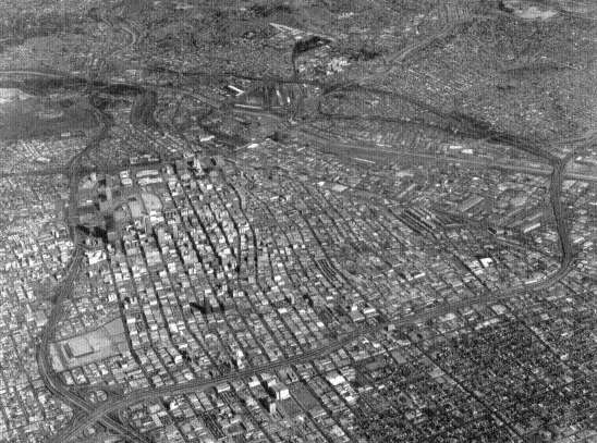
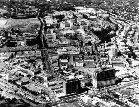
72. Downtown Los Angeles Freeway Circuit, 1970. Because of the speed and ease of automobile travel, a conventional retailing, office, and manufacturing core became but one center in a network of scattered concentrations. California Division of Highways, District VII
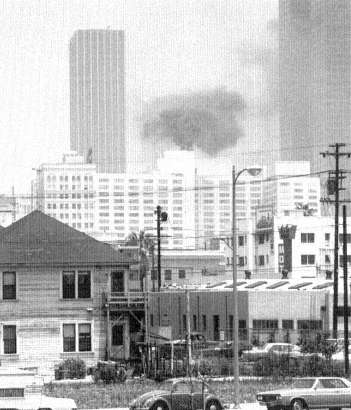
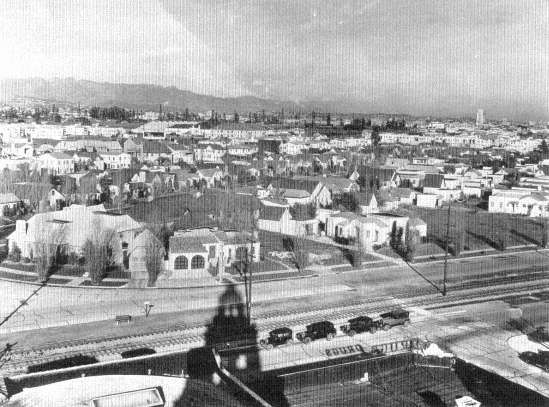
73. Looking Toward the Downtown from the Convention Center, Los Angeles, 1971. As in all American cities, the new corporate office towers symbolize the increasing bureaucratization of the urban economy and provide the dynamic element in the refashioning of old city cores into more narrowly specialized office and government centers. Mason Dooley
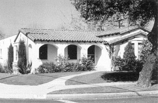
74. Raymond Avenue, Los Angeles, 1971. The near-universal cultural goal of a city of private homes shaped the potential of the automobile into the reality of Los Angeles. Mason Dooley
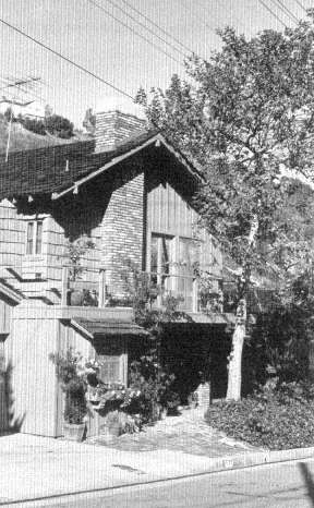
75. Stone Canyon, Sherman Oaks, 1970. Although Los Angeles' housing styles have been widely copied, the informal garden characteristic of California modern has generally been employed to intensify the inward-turning, private-family orientation of traditional American urban housing styles. Mason Dooley
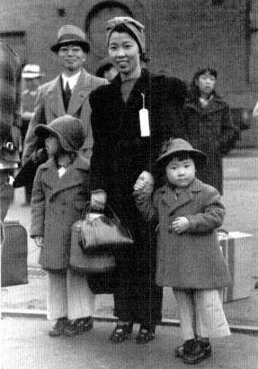
76. Japanese-Americans Awaiting Removal to Concentration Camps, Los Angeles, 1942. The special contribution of Californians to American white racism was their fear of and hostility to Orientals. Wartime panic and xenophobia climaxed decades of earlier discrimination. Today's legacy is a precedent which threatens every American's civil liberties, and the permanent loss of a lively Japanese component in the culture of the metropolis. Library of Congress
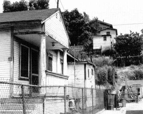
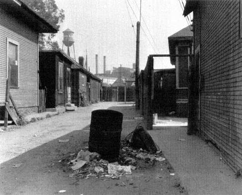
77. Boyle Heights, Los Angeles, 1971. The trickle-down housing market in the Mexican-American east side. The low density of typical twentieth-century Los Angeles building has saved the city from the worst sanitary and overcrowding effects of earlier styles of slum housing. Mason Dooley
Elements of Growth
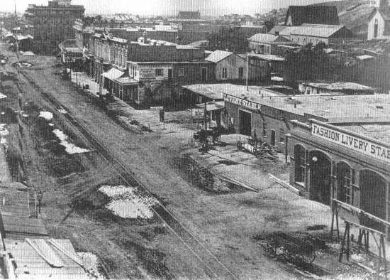
78. Main Street, Los Angeles, ca. 1875. Los Angeles began like all American cities with a shopkeepers' street of drygoods stores, livery stables, saloons, and hotels. View from the Plaza south toward the present downtown core. The Santa Ana Freeway now crosses Main Street beyond the first intersection. History Division, Los Angeles County Museum of Natural History
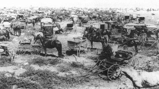
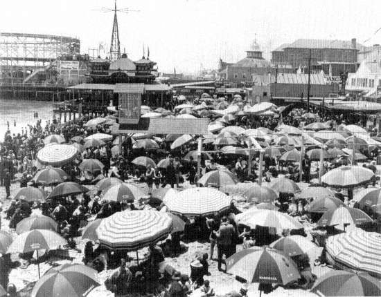
79. "Parking Lot" at Long Beach, 1905. The first of Los Angeles' special assets was its climate, but the cost of a horse and carriage for a time preserved urban recreation spaces for exclusive middle-class use. History Division, Los Angeles County Museum of Natural History
80. Streetcar Beach, Long Beach, ca. 1920. Street railways brought mass commercial exploitation of the Pacific shore, partially overcome by the subsequent extensive development of public automobile access beaches. History Division, Los Angeles County Museum of Natural History
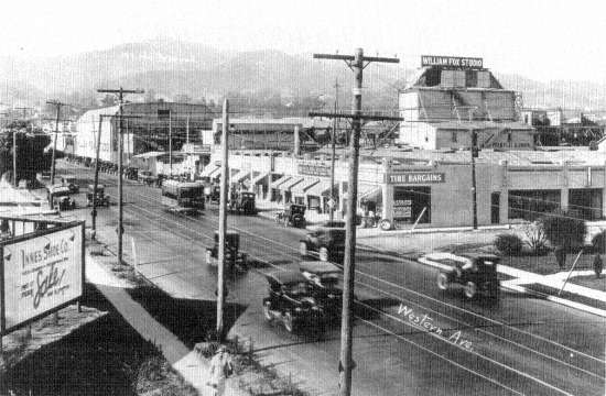
81. William Fox Studio, Western Avenue and Sunset Boulevard, Los Angeles, 1927. Continuous sunshine drew the new movie industry from its earlier metropolitan New York locations. History Division, Los Angeles County Museum of Natural History
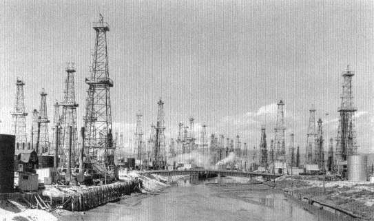
82. Del Rey Oil Fields, Los Angeles, 1930. The oil boom of the twenties added a second impetus to the city's growth, starting it on its path to industrial diversification. History Division, Los Angeles County Museum of Natural History
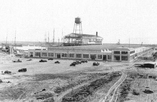
83. Ford Assembly Plant, Long Beach, 1929. With the take-off of Los Angeles in the twenties, growth begat growth, and national firms began to locate regional plants in the metropolis. Historical Collections, Security Pacific National Bank
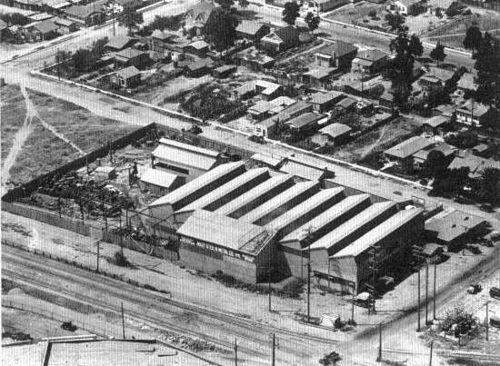
84. Union Pacific Industrial Area, Vernon, 1924. Modern zoning laws intensified the rail orientation of American urban industry by specifying such land for factories only. In Los Angeles old rail alignments continue to function as the skeleton for industrial expansion. Historical Collections, Security Pacific National Bank
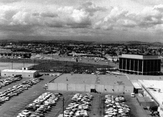
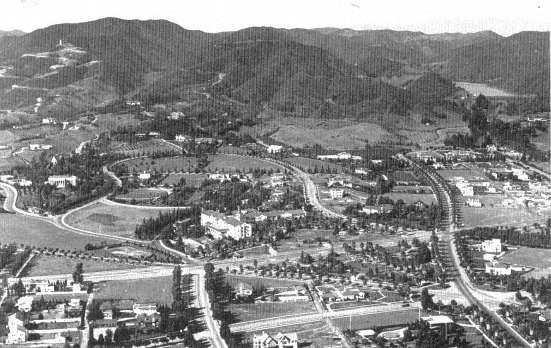
85. The earlier railroad-sponsored industrial development has reached in our own time the ultimate form of a planned satellite city. Here 35 miles from the downtown, developers have laid out a 4,000-acre tract with 350 firms and multiple transportation service: the San Diego and Newport freeways, Orange County airport, and a spur of the Atchison, Topeka and Santa Fe. The Irvine Company
Centers
86. Hill and 9th Streets, Downtown Los Angeles, 1924. Far more dispersed than its predecessors, the central cluster grew until World War II in the conventional form of a multipurpose, retail, office, government, theater, hotel, wholesaling, and manufacturing center. History Division, Los Angeles County Museum of Natural History
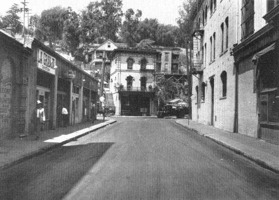
87. Republic and New High Streets, Los Angeles, ca. 1925. As in all cities, the immigrant quarters appeared at the fringe of the downtown. Here, the Mexicans have taken over shops and houses abandoned by their Yankee predecessors. History Division, Los Angeles County Museum of Natural History
88. Beginnings of the Civic Center, Los Angeles, 1940. Since the early twentieth century, huge and expensive government buildings were deemed to foster citizenship and heightened civic pride. Los Angeles refashioned its downtown with arid malls and colossal government offices, monuments to bureaucratization. The first stage: City Hall, 1927 (left), U.S. Court House, 1937 (right). History Division, Los Angeles County Museum of Natural History
89. A Quarter of a Mile from City Hall, Los Angeles, 1936. Mexican-American slum housing at the industrial fringe of the downtown. Library of Congress
90. Brand Boulevard, Glendale, ca. 1926. Typical suburban subcenter eight miles from the downtown with the Pacific Electric Railway's "big red cars" stopped on the main street. Until left-turning automobiles clogged the streets and grade crossings, a 1,200-mile electric interurban system enabled Los Angeles to function as a single suburbanized, low-density, multicentered metropolis. History Division, Los Angeles County Museum of Natural History
91. Manchester Avenue and Santa Ana Freeway, Anaheim, 1965. Shopping centers with big stores and specialty shops, service roads, and freeways have solved automobile traffic circulation problems, but fail as social institutions because private developers cannot profitably offer low-rent space. California Division of Highways, District VII
92. Westwood Village, Wilshire Boulevard, Los Angeles, ca. 1965. Wilshire (lower left to right) connects a line of high-income settlements running from the old downtown through Hollywood and Beverly Hills to Santa Monica. A continuous downtown, it is lined with stores and parking lots and at intervals with specialized apartments and office subcenters. Here is the University of California node (upper center); note the large proportion of street and parking area. History Division, Los Angeles County Museum of Natural History, Spence Air Photo
Homes
93. Working-class Housing, 55th and Alameda Streets, Los Angeles, ca. 1930. Relative cheapening of land brought by the automobile meant a slight enlargement of the most inexpensive house lots, a bit more open than
comparable rapid-transit-and-street-railway-dominated Chicago and New York mass housing. Historical Collections, Security Pacific National Bank
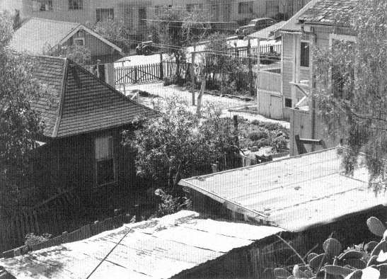
94. Yards in Colon Street, Wilmington, 1945. The extra increment of land allowed working-class housing to age well. Garages could be converted into rentals and still meet minimum sanitary and fire safety standards; garden fragments could survive even in the lowest-income neighborhoods. Mason Dooley
95. Whittier Boulevard near Atlantic Boulevard, East Los Angeles, 1924. Subdividers continued to follow the standard American grid street and rectangular house lot practice used to parcel out the nation's land since the westward movement began. Historical Collections, Security Pacific National Bank
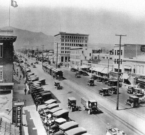
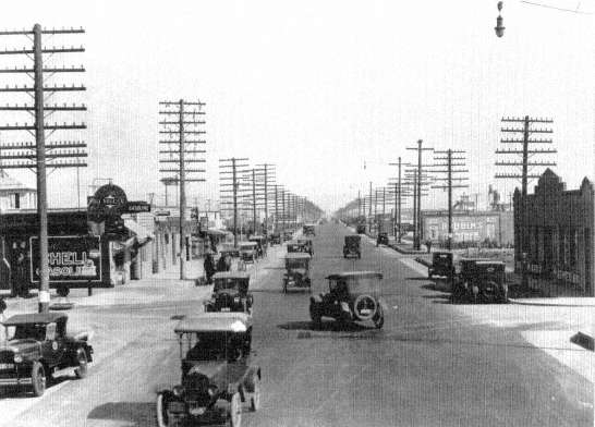
96. Whittier Boulevard, Belvedere, ca. 1924. Main street became the endless shopping strip. History Division, Los Angeles County Museum of Natural History
97. San Vicente Boulevard at Crescent Heights, Los Angeles, 1929. The prosperous middle class fared little better than the mass at the hands of private real-estate developers. Expensive houses, in English cottage, Spanish and American colonial styles, crowded the small rectangular lots. History Division, Los Angeles County Museum of Natural History
98. Sunset and Beverly Boulevards, Beverly Hills, 1924. Only the wealthy benefited from the garden potential of southern California suburbs: hill sites, large grid lots adapted to streets following contours of the land, small parks and extensive street plantings preceded the luxury-home buyer. County of Los Angeles Regional Planning Commission, Spence Air Photo
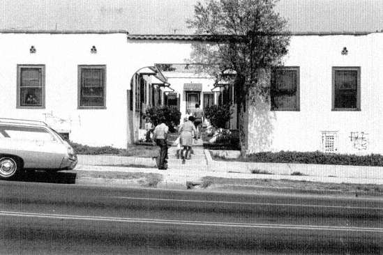
99. Court, 1st Street, Boyle Heights, Los Angeles, 1971. The only useful innovation of Los Angeles urban architecture was the mutiple-family courtyard. It began as a mean small-apartment barracks set in a U shape along a single walk, filling an entire rectangular lot. This primitive practice continues today in the cheapest motor courts. Mason Dooley
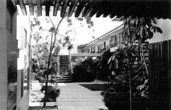
100. Court, Pinafore Street, Baldwin Hills, Los Angeles, 1971. Since World War II middle-income families have been attracted to an expanded court design, now often in a hollow square, two and three stories high, requiring several rectangular house lots. Peripheral parking, central garden and swimming pool are standard amenities, a kind of apartment design that overcomes both the social isolation and parking problems of the more land-conserving apartment blocks of Eastern cities. Mason Dooley
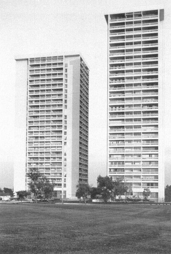
101. Apartment Towers, Avenue of the Stars, Century City, Los Angeles, 1971. In marked contrast to the courts, which will decay humanely, Los Angeles developers erect on expensive and fashionable land luxury apartment towers, which maximize isolation of tenant from tenant, and tenants from the surrounding city. In half a century, when today's mortgages are paid off, the city as a whole will inherit heavy social costs as these structures decay into the worst kind of slum rookeries. Mason Dooley
72.
Downtown Los Angeles Freeway Circuit, 1970
73.
Looking Downtown from the Convention Center, 1971
74.
Raymond Avenue, Los Angeles, 1971
75.
Stone Canyon, Sherman Oaks, 1970
76.
Japanese-Americans Awaiting Removal to Concentration Camps, Los Angeles, 1942
77.
Boyle Heights, Los Angeles, 1971
78.
Main Street, Los Angeles, ca. 1875
79.
"Parking Lot" at Long Beach, 1905
80.
Streetcar Beach, Long Beach, ca. 1920
81.
William Fox Studio, Los Angeles, 1927
82.
Del Rey Oil Fields, Los Angeles, 1930
83.
Ford Assembly Plant, Long Beach, 1929
84.
Union Pacific Industrial Area, Vernon, 1924
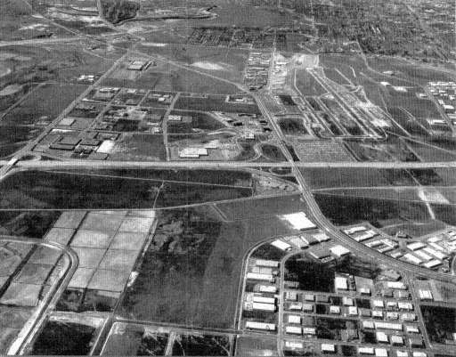
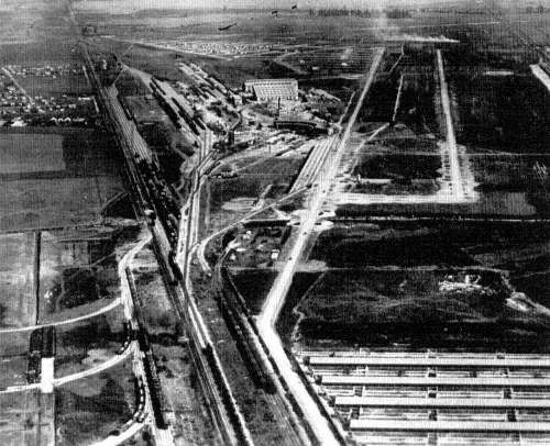
85.
Irvine Industrial Park, 1971
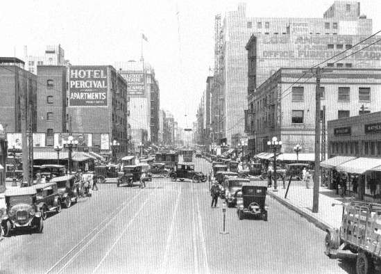
86.
Hill and 9th Streets, Downtown Los Angeles, 1924
87.
Republic and New High Streets, Los Angeles, ca. 1925
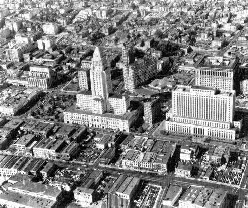
88.
Beginnings of the Civic Center, Los Angeles, 1940
89.
A Quarter of a Mile from City Hall, Los Angeles, 1936
90.
Brand Boulevard, Glendale, ca. 1926
91.
Manchester Avenue and Santa Ana Freeway, Anaheim, 1965
92.
Westwood Village, Los Angeles, ca. 1965
93.
Working-Class Housing, Los Angeles, ca. 1930
94.
Yards in Colon Street, Wilmington, 1945

95.
Whittier Boulevard, East Los Angeles, 1924
96.
Whittier Boulevard, Belvedere, ca. 1924
97.
San Vicente Boulevard, Los Angeles, 1929
98.
Sunset and Beverly Boulevards, Beverly Hills, 1924
99.
Court, Boyle Heights, Los Angeles, 1971
100.
Court, Baldwin Hills, Los Angeles, 1971
101.
Apartment Towers, Century City, Los Angeles, 1971
a widely diversified metropolis given over to manufacturing, commerce, service, and war production.[33]
During the twenties and thirties, irrigated agriculture, oil discoveries, the motion-picture boom, and waves of Midwestern and Texan migrants seeking a pleasant place to live and work swelled the city's size. Oil revenues in part financed the construction of an ocean port at Long Beach, and favorable rail connections to the Southwest and the East (the city lies a few miles closer to Chicago than San Francisco does) made Los Angeles a preferred site for warehouses and branch plants of national corporations. During the twenties, for example, both Ford and Goodyear built Pacific plants there, and many other firms followed suit. But the city was handicapped by the circumstance that its factories were some two thousand miles from the western edge of the Midwestern manufacturing belt at St. Louis. Therefore the sectors of the metropolitan economy devoted to general machinery and metalworking—sectors of vital importance to a fully elaborated industrial region—did not develop during these years. Los Angeles in 1940, for all its impressive size, was not yet committed to manufacturing.[34]
Thirty years of almost continuous hot and cold wars ended this anomaly. Tremendous aircraft orders from the federal government not only caused that particular industry to shoot ahead, but federal sponsorship of aerospace research and all sorts of war material fostered supportive manufacturing, until today the city is the only fully diversified manufacturing region outside the belts of the Northeast and Midwest. To be sure, Los Angeles still has its agricultural, aircraft, electronic, and movie specialties, just as Chicago still concentrates on steel, machinery, and printing and New York on garments, leather, printing, electrical equipment, and national offices, but since the 1950s a full range of complementarities has been available in Los Angeles to boost further expansion.[35]
Three special characteristics of the Los Angeles metropolis stand out by comparison with the earlier examples of New York and Chicago:
[33] . Perloff et al., Regions, Resources, and Economic Growth , pp. 462, 465, 471-75.
[34] . Frank L. Kidner and Philip Neff, An Economic Survey of the Los Angeles Area , Los Angeles, 1945, pp. 1-26; Robert M. Fogelson, The Fragmented Metropolis, Los Angeles 1850-1930 , Cambridge, 1967, pp. 108-34.
[35] . U.S. Bureau of the Census, Census of Manufactures, 1967, Summary Series: General Summary MC 67 (1)-1 , Washington, 1970, Table 2; Census of Manufactures, 1967, Area Series: California, Illinois, New York, MC 67 (3)-5,-14,-33 , Washington, 1970, Table 6.
its high degree of spatial freedom, its potential for a more equitable and inclusive class and racial society, and its growth in response to deliberate federal programs.
The land-use and transportation structure of Los Angeles gives glimpses of a more humane environment than we have yet enjoyed. The special factor of the city's social geography is its low density of settlement, the ease and scope of movement of the overwhelming proportion of its citizens, and its comparative lack of domination by a single downtown area. It has thus escaped the rigid core, sector, and ring structure of business and residential occupation that tyrannized the industrial metropolis and from which older cities are only now beginning to extricate themselves. Los Angeles is an amorphous metropolis, and vast tracts of it have a rather uniform low-density settlement of five to twenty-four persons per acre. Along the Pacific in the Santa Monica and Long Beach areas and in a crescent of housing from Santa Monica through Beverly Hills to the old core city there are apartment houses and multiple-dwelling neighborhoods that resemble those in Chicago or New York. Also scattered through the metropolis, especially along its shopping strips, stand many of the motel-like courts that are the contemporary slum-tenement style of the American city; but the single-family dwelling has long been the glory of Los Angeles and the expression of its design for living. Sixty-four percent of all its occupied housing in 1967 was given over to single-family dwelling units.[36]
The plan for a metropolis composed of single-family houses did not emerge from the drawing boards of freeway engineers; their constructions followed an already entrenched preference of the Angelenos. During the twenties three social factors had converged to establish the Los Angeles plan: the cultural preference of Americans for detached private homes, the need to supply water for burgeoning land development, and the sheer pleasure and freedom bestowed by the automobile.
Three out of four of the army of migrants who came into southern California during the early part of the twentieth century were white native-born Americans from the cities to the east and from the farms and small towns of the Midwest.[37] City dwellers and farmers alike brought with them an ingrained tradition of the single-family house as
[36] . Los Angeles Regional Transportation Study, "1967 Origin-Destination Survey, Summary of Findings," Draft, November 18, 1970, p. 31.
[37] . Stephan Thernstrom, The Growth of Los Angeles in Historical Perspective: Myth and Reality , Institute of Government and Public Affairs, University of California, Los Angeles, 1970, pp. 8-11.
the measure of a home and of Main Street or suburbia as the measure of satisfactory living. The American has often had to share his housing with others—in rented rooms, in two-family houses, in tenements of three, six, or more flats—but given the opportunity he has customarily sought a house of his own. Moreover, just as in the case of Chicago's middle class, in the Los Angeles region no thirst for the big-city life of skyscrapers, restaurants, and theaters has tempted him to sacrifice the privacy of a tree-shaded lawn and garden for apartment luxury or for the urban habits of the nineteenth-century inhabitants of European or American industrial cities. In sum, people came to southern California seeking a warm, sunlit, home-town city.
To provide these amenities in the first decades of the twentieth century in the face of the aridity of Los Angeles, residential property carried high land-preparation costs and so had to be developed in tracts of considerable size. An expensive water supply had to be meshed with public transportation to a degree unheard-of in the modest subdivisions common in Eastern cities. Speculators capitalized on the situation by building a wide-range complex of electric interurban streetcars. They hoped that their initial investment in lines that stretched from twenty to thirty-five miles out from the downtown area would be justified by massive profits from future land development and ensuing heavy traffic on their routes. Los Angeles in 1920, compared to other cities of the period, was extraordinarily extended into large-scale suburban development.[38]
The automotive boom of the twenties carried these trends toward diffusion to modern proportions. The general ownership of automobiles and their use in commuting allowed developers to open up smaller tracts beyond walking distance from the interurbans. When these lines began to lose money from competition with automobiles and when traffic jams in downtown Los Angeles became intolerable, the municipality called for the construction of a rapid-transit system to alleviate traffic, revitalize the street railways, and save the downtown. Other cities had voted for subways in the twenties, but Los Angeles did not follow the precedents; its citizens voted down the proposals. Their city was so new and open that they had no image before them of a desirable downtown, and they had no habit of listening to the appeals of downtown business leaders.
[38] . Fogelson, Fragmented Metropolis , pp. 85-107; Kelker, De Leuw & Co., Report and Recommendations on a Comprehensive Transit Plan for the City and County of Los Angeles , Chicago, 1925, plates 12, 18.
Then, too, their tradition told them that happiness lay in another style of life.[39]
During the Great Depression the public transportation system cut back its service, and after World War II the interurban lines closed down; today the public bus lines handle a small volume of passengers—400,000 fewer than in 1939. Without the discipline of street railways, commerce drained from the core city to spread out along strips of land like Wilshire Boulevard. Suburban towns like Glendale and Pasadena established their own downtowns, and suburban shopping centers and office clusters have sprung up to form a multicentered metropolis.[40]
The key decision in the determination of the spatial freedom of its residents came in 1939, when the Los Angeles Freeway plans were settled into a multicentered pattern. A failing public transit, serious traffic jams, and a new state statute that permitted construction of limited-access highways had prompted the City of Los Angeles to commission still another study of its transportation problems. The Works Progress Administration of the federal government carried out a traffic census, and on the basis of these findings the City of Los Angeles Transportation and Engineering Board made its recommendations; freeways would be the solution to the region's traffic difficulties. The unusual multicity and multicounty membership of the advisory board may have accounted for its metropolitan orientation. Besides Los Angeles officials, representatives from such scattered places as Glendale, Beverly Hills, Redondo Beach, Huntington Beach, Whittier, Pasadena, and the San Fernando and San Gabriel valleys sat on the board. The 1939 plan called for limited-access express highways to be laid out in the form of a giant grid, which would be capable of carrying automobile traffic both into and out of the overcrowded Los Angeles central business district and would guide it across the city without the necessity of its going through the downtown area. The principal justification for this plan was the board's recognition of the already highly dispersed character of the region. Many of its alignments were to follow the much-traveled state highways that crisscrossed the area. The report may well have reflected too the politics of the Transportation Board itself. Although no record survives of its discussions, it seems highly probable that the members
[39] . Reyner Banham, Los Angeles: The Architecture of Four Ecologies , New York, 1972.
[40] . Fogelson, Fragmented Metropolis , pp. 164-85; Pacific Southwest Academy of Political and Social Science, Los Angeles, Preface to a Master Plan, Publication 19 , Los Angeles, 1941, pp. 47-53, 161-68, 173-88.
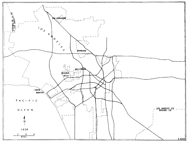
Figure VI.
Los Angeles Freeway Plan of 1939
SOURCE: City of LOS Angeles, Transportation and Engineering Board,
A Transit Program for the Los Angeles Metropolitan Area , Los Angeles, December, 1939.
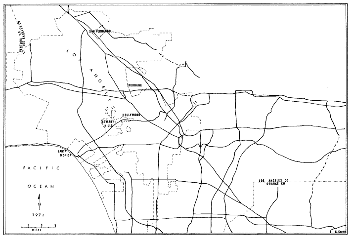
Figure VII.
Los Angeles Freeways in Operation, 1971
SOURCE: California Department of Public Works, Division of Highways,
District VII Freeway and Expressway System Map , Los Angeles, January, 1971.
from the more distant areas would not have accepted the conventional hub-and-wheel design that was at this time being proposed for old American single-core cities, since such a plan would have drawn business away from their own centers. The board did expect, however, that Los Angeles would eventually grow to be a conventional single-centered city and that in time commuter railroads and subways would be required.[41]
The 1939 proposal for freeways derives its historical importance from the fact that it was subsequently adopted and adapted in a succession of plans and projects. The first undertakings, begun in 1940 with the Pasadena Freeway, all converged on the downtown (the Hollywood, San Bernardino, Santa Aria, and Harbor Freeways), thereby beginning a radial scheme for serving the downtown, but wartime and postwar planning studies continued to repeat the basic grid strategy of the 1939 report. Then in 1956, when the federal government passed its Interstate Highway law, the California legislature set up a committee to establish routes for the state. The routes that were then adopted incorporated the 1939 proposal for a grid system of metropolitan freeways, and many such highways have been built in the ensuing years.[42] The grid is still being extended at its outer margins in order to keep up with the spread of the metropolis, and it is being added to at the center to relieve traffic congestion further, but for many years now Los Angeles has enjoyed a transportation system that permits its residents to move swiftly from subcenter to subcenter over the entire region without having to go through the downtown or any lesser center.[43]
The social consequences of the multicentered, low-density metropolitan region are manifold and are important to our urban future. First and foremost was the increase in the job choices offered the urban resi-
[41] . City of Los Angeles, Transportation and Engineering Board, A Transit Program for the Los Angeles Metropolitan Area , Los Angeles, December 1939; "California Highways . . . 1964," California Highways and Public Works , 43 (November-December 1964), 5-12.
[42] . Los Angeles Metropolitan Parkway Engineering Committee, Interregional, Regional, Metropolitan Parkways , Mimeographed March 30, 1946, Los Angeles Regional Transportation Study Library, pp. 1, 5; "Freeway Development on Highways of California," California Highways and Public Works , 24 (January-February 1946), 30-34; "Report from District VII," California Highways and Public Works , 37 (January-February 1958), 2-16; California Department of Public Works, Division of Highways, The California Freeway System, Report to the Joint Interim Committee on Highway Problems , Sacramento, September 1958, p. 18.
[43] . California Department of Public Works, Division of Highways, District 7 Freeway and Expressway System Map , Los Angeles, January 1971.
dent. In 1967 there were three automobiles for every seven persons in the Los Angeles region; 41 percent of the households had access to one vehicle, 44 percent had access to two or more vehicles, and only 15 percent of the households lacked a car.[44] Such a distribution of automobiles and freeways gives the Los Angeles employee the widest choice of job opportunities ever possible in an American city. An hour's drive from any point in the region makes hundreds of possible employers accessible. A man can live in the San Fernando Valley and work in the old industrial sector of southeast Los Angeles, or he can commute from the old core-city neighborhoods to the new steel mills at Fontana. These are extreme commuting distances, to be sure, but recent studies show that blue-collar workers in particular are crisscrossing the whole area in search of the best jobs.[45] In the past urban workers were pinned down to living next to their mills, or they purchased their economic freedom by commuting from crowded core-city working-class and slum districts along the radial lines of the streetcar system. These journeys were long, the cars crowded and slow, and transfers and waits in the cold and wet often necessary. Such trials cannot be compared with the ease of an hour's run today in a private car or car pool. In Los Angeles most commuters go directly from their home to the company parking lot, and the majority travel alone; more than 70 percent of all weekday automobile trips are taken by a single driver.[46]
To this economic freedom must be added the social advantages that have accrued to the Los Angeles public. The greater number of car trips are not work-related at all but are undertaken for social or recreational purposes or for shopping. Thus scattered friends and relatives, long shopping strips and outlying shopping centers, the Pacific beaches, and national parks are all within easy reach of most families. At the same time the city is able to grow by continuing to build in its low-density popular single-family or low-rise apartment-court style.
Like all American cities, the Los Angeles automobile metropolis does not extend its amenities equally to all its residents but reinforces sharp differences governed by class and race. Boyle Heights, an early twentieth-century neighborhood in East Los Angeles, offers some of the attractions of small-town life to its Mexican-American residents. Watts
[44] . LARTS, "1967 Origin-Destination Survey," p. 33.
[45] . Lawrence E. Maxwell, "Residential Distribution of Occupations in Los Angeles," unpublished M.A. thesis, University of California at Los Angeles, 1966, pp. 60-64, 70, Map 5.
[46] . LARTS, "1967 Origin-Destination Survey," pp. 39-41.
and the black ghetto have many of the same features. Yet the poor, lacking cars and perhaps also fearful of their reception in other parts of the metropolis, do not travel over large sections of the region as residents of the San Fernando Valley might do.[47] Women and old people especially suffer from a dearth of cars. The women thus lack access to jobs that would boost family income, and to essential shopping and health services. For the men, transportation doesn't seem to be the problem. Once they find employment they seem to be able to purchase cars on time.[48]
The solution to the disadvantaged position of those without cars is neither difficult nor expensive, but like all our cities Los Angeles remains heedless of the needs and suffering of its poor, its blacks, its Mexican Americans, and its old people. After the Watts riot the transportation problems of the poor were made plain, and the state of California, with federal funding, set up a demonstration project in southeast Los Angeles to attempt to deal with the problem. A social science team intervened in behalf of the poor in several ways. They became the spokesmen of the neighborhoods before the bus companies; they waged campaigns to have route maps printed and distributed and to persuade the companies to post the schedules at the bus stops. They discovered that the last bus might leave a factory's gates a few minutes before the men finished their daily shifts; they discovered routes that could be instituted or altered to reflect the commuting habits of the residents. It seems clear from the findings of this team that the cost cutting of private and public bus companies should be monitored in every city by a political agency representing the transportation interests of those outside the circle of the automobile world. The altering of existing public transportation, however, was not sufficient. The women needed short runs along shopping strips and to shopping centers and they needed long trips in every direction to reach scattered job sites. To this end the experiment rented buses for some new regular routes and also used station wagons and cars for a kind of metropolitan taxi service
[47] . City of Los Angeles, Department of City Planning, The Visual Environment of Los Angeles , Los Angeles, April 1971, pp. 9-11; this seems to be a worldwide phenomenon in modern cities accounted for largely by the failure of old rapid-transit systems to keep pace with the growth of cities. "Cars or Busses?" The Economist , 240 (August 14, 1971), 48-51.
[48] . State of California, Business and Transportation Agency, Transportation-Employment Project, Interim Final Report , Los Angeles, January, 1970, pp. 15, 27-30, 98; U.S. Department of Labor Statistics, Employment and Unemployment in East and South Los Angeles, Regional Report No. 14 , San Francisco, 1971, p. 21.
to jobs at such widely dispersed destinations as Lockheed in Burbank, Douglas Aircraft at Long Beach, Torrence, and Santa Monica, American Electric at La Mirada, and Sergent-Fletcher in El Monte. The cost of these services was high, but could have been much reduced if established permanently. The demonstration project was a success, but in 1971, when the funds were gone, predictably the grant by the federal government was not renewed and the service closed down.[49]
Judging from this experience, a few millions of dollars a year spent in maintaining an agency to represent the carless and offer its own flexible small-bus service would redress the worst of the access problems attendant on Los Angeles' unequal distribution of family income. To be sure, those without cars are the ones who suffer most from low wages, from job discrimination against women, old people, blacks, and the ill-educated, and from regional and national callousness toward the unemployed and the underemployed, but even a modest effort would be far more useful to the poor than the currently fashionable enthusiasm for rail lines. Railroads by their very nature offer high-volume service only along their own narrow strip. Los Angeles is neither a linear nor a radial city; it is a multicentered city that calls for multidestination public transportation.
Finally, although Los Angeles does not have the problem of choking traffic jams and hard-to-reach areas like those of New York, it does have a serious air-pollution problem. In view of the enormous investment and great social success of the freeways, it seems foolish not to try to eliminate the smog in similar terms. Surely the technology of the moon era is capable of manufacturing low-emission engines as an alternative to the present disgraceful pollution created by Los Angeles' 4.5 million automobiles.
Since all of the metropolises and the three megalopolises of the United States are growing into the form of Los Angeles, it is important that we understand the social potential of this diffuse layout of building. The open character of Los Angeles has resulted in a land-use structure more favorable for the achievement of racial and class justice than any that has so far existed in any large American city. This structure is only a potential for justice, however, and remains far from realization.
Los Angeles is no better than most cities when it comes to racial discrimination, segregation, and disadvantages for its poor. The county
[49] . California Business and Transportation Agency, Interim Final Report , pp. 85-90.
population is 10.8 percent black, 13.5 percent of Spanish surname. The isolation of blacks is almost as extreme as in Chicago. The Mexican Americans are less rigidly segregated from the Anglo Americans than are the blacks, but nonetheless they are highly segregated.[50] When the frustration of the black community exploded with the Watts riots of 1965, a national chain reaction was set in motion, and since that time there have been a number of Mexican-American riots expressing the conflicts of another disadvantaged community. All the hostility and failings of our society, so fully documented in 1968 by the Kerner Commission and in other reports, are part of Los Angeles as well. But if it wishes to build a more inclusive society, it has a special advantage in the availability of land for redevelopment and in abundant fringe land for new construction. The prerequisite for making good use of the land in terms of its society is a commitment by the national government and the Los Angeles public and its officials to make a decent house and neighborhood open to every resident. With such a commitment, new housing can become the framework for an inclusive urban society, rejecting the city's present mechanism for class, racial, and ethnic segregation.
The original low density of Los Angeles' construction has saved it from mortgaging its future. Its built-up areas are not so crammed with structures that new construction in old areas brings serious dislocation of present residents, as is the case in Chicago or New York. There is vacant land all over the Los Angeles region. This land is in the form of weedy lots and unused spaces, some large enough for development in their own right, some requiring some demolition of adjacent houses. If public agencies were to build on five-acre tracts they would find land, either vacant or sparsely occupied, by the hundreds of parcels all over the city. Such land is ideal for the design and construction of low-rise apartments, two-family housing, and town houses. In other words, existing styles of housing could become the basis for a massive public housing program that would not disrupt the physical fabric of the city. Federal programs for land clearance, housing, and rent subsidies allow such housing to be offered today to the fourth of the Los Angeles population who cannot afford decent housing at present prices. Such
[50] . Los Angeles County, Human Relations Commission, "Population by Major Ethnic Grouping, Los Angeles County, 1950, 1960, 1970, Projection for 1980," HRC Research , June 1971; Leo Grebler, Joan W. Moore, and Ralph C. Guzman, The Mexican-American People , New York, 1970, pp. 274-78; City of Los Angeles, Community Analysis Bureau, State of the City, Conditions of Blight and Obsolescence , Los Angeles, 1970, pp. 72-73.
federal programs, however, would have to be so funded as to allow for a large-scale and sustained undertaking.[51]
At least three important social consequences would be derived from such a small-parcel program. First, the chronic shortage of low-income housing would be relieved. Second, the abundance of scattered sites would enable blacks, Mexican Americans, and the poor to choose to settle either near their present neighborhoods or in new distant sections of the city. The degree of social pioneering undertaken by any family would be according to their own choice and would not depend on the decision of public authorities. Third, the five-acre tracts would have to be designed to fit into the styles prevailing in their environs or else face strong local opposition. Perhaps this requirement that design attain at least the levels of popular taste would save the projects from the degradation of some of the philanthropic architectural styles that now stigmatize public housing.
At its fringes the Los Angeles freeway brings large tracts of vacant land within the reach of commuters. This same situation prevails in the Eastern and Midwestern megalopolis and all metropolises. Here publicly sponsored or managed new towns of 50,000 to 200,000 residents could be used as a device for increasing the residential options of black and low-income families. The key advantage of the new-town concept, or entire-city building scheme, over the conventional suburban subdivision lies in its coordination of public facilities with employment and housing. The new town can be built around industries to provide jobs for a range of skills and classes. The schools and health services can be built in the beginning so that the residents do not create unnecessary conflict by overloading small local community services. Finally, because these would be large projects, the social engineering of building at all class levels would become feasible. Los Angeles is currently building a beautiful new town at Irvine. Its extent is 53,000 acres, and it will ultimately hold 430,000 inhabitants.[52] It has jobs, recreation, an airport, and community facilities laid out in such a way that the native California land form is undisturbed. It is a brilliant example of the advantage of large-scale new-town development over the spread of subdivisions. Despite all this, Irvine is a social scandal—an all-white, upper-middle-class enclave. It is exactly the sort of project that at once shows the high
[51] . Regional Planning Commission, County of Los Angeles, Environmental Development Guide , Revised Draft, Los Angeles, September 1, 1970, pp. 64—75.
[52] . Irvine World News , April, 1970.
potential of the new metropolis and its bigoted, class-bound failure to realize that potential.
Finally, Los Angeles should be understood as an outstanding example of regional and national planning. Its port at Long Beach, its interstate water-supply system, and its national parks and forests are excellent examples of well-designed and coordinated large-scale planning. Its war-stimulated growth is of interest precisely because it demonstrates an important but as yet little exercised capability of the federal government to influence the prosperity of a metropolitan region. The Los Angeles experience shows that we have depressed cities and depressed regions only because we have chosen to let them go unattended.
Several principles governing a successful national urban policy can be derived from the federal sponsorship in Los Angeles. First, federal orders for products and services, direct intervention in the construction of plants, and long-term aid in the building of water and electric facilities encouraged and sustained its growth.[53] In the case of huge aircraft orders and the subsequent erection of aircraft plants with federal funds, the investment helped an industry that had already taken root to settle in more firmly. The additional contracts in the fields of aerospace and war material were instrumental in bringing the blossoming electronics industry into the city from the East.
Second, the magnitude of orders and assistance exceeded any later federal attempts to foster business in depressed areas through favored purchasing, small-business loans, and Office of Economic Opportunity programs. Aside from the money spent for war material, tools were being forged here for a national policy directed to urban growth and regional employment guidance, but our low-key use of these tools and our compulsion to tie them to the Congressional pork barrel have rendered them ineffective.[54]
Third, the federal infusion of capital into the area continued over a long period—at least thirty years—without serious interruption, so that the war specialties of Los Angeles have been consistently nourished.
Fourth, the Los Angeles case showed that special institutions could be used to upgrade a regional labor force that had been neither particularly skilled nor outstandingly intelligent. The government sponsored here the foundation of nonprofit research and development corpora-
[53] . Kidner and Neff, Survey of the Los Angeles Area , pp. 101-3.
[54] . Lloyd Rodwin, Nations and Cities, A Comparison of Strategies for Urban Growth , Boston, 1970, pp. 222-35.
tions, such as RAND and the Systems Development Corporation, to supplement the educational and research capabilities of the California Institute of Technology, the University of Southern California, and the University of California. These additional institutions, by attracting scientists and engineers to the region, did much to accelerate the city's movement into higher levels of technology, and at a pace more rapid than would have prevailed if the city had depended only upon its universities and the technical staffs of resident aircraft and electronic concerns.[55] In the Boston metropolitan region, similar paramilitary institutions helped raise the level of a management and labor force formerly connected to the dragging textile industry, and it seems probable that the Houston Manned Spacecraft Center will have the same effect in Texas. These instances suggest that the federal government could create research and service institutions for civilians as a device to upgrade the industries and labor forces of such places as Atlanta, Chicago, Detroit, and New York.
Fifth and finally, the federal investment in Los Angeles, moved by an unconscious planning wisdom, supplemented and stimulated an existing trend. There was no effort to reverse the path of popular migration or to go against the locational trends of the economy as might have been the case in such places as Appalachia or East St. Louis, Illinois. It is obvious that to roll with the economy, to relieve temporary distress, and to help people to move is a prerequisite for national urban programs.
What the federal effort in Los Angeles lacked was self-conscious dedication. The United States has the tools to plan its regional and national urban growth through the twin job-awarding devices of the giant corporation and the federal budget. Since World War II the magnitude of the corporate and federal effort has in large measure determined the national location of jobs;[56] it has designated the industries and places where jobs would be plentiful and where they would be sparse. The depressed condition of the core of New York City is a casualty of the federal and corporate concentration on war just as surely as the prosperity of Los Angeles is its hero. If we are to mitigate the appalling human waste and suffering of our cities, both institutions must be made
[55] . Christopher Rand, Los Angeles, The Ultimate City , New York, 1967, pp. 72-100.
[56] . Murray L. Weidenbaum, Federal Budgeting, The Choice of Government Programs , Washington, 1964, pp. 4-22; Douglass B. Lee, Jr., and John W. Dyckman, "Economic Impacts of the Vietnam War: A Primer," Journal of the American Institute of Planners , 36 (September 1970), 298-309.
to act as self-conscious agents of urban reordering. The federal government must follow European examples by adopting a carefully considered, politically viable policy for urban growth so that the modernization of our cities and our economy can go forward more humanely; the corporations must be socialized to the point at which they can be held accountable for the public consequences of their behavior. Like the legitimate demands for decent work, comfortable housing, and an open inclusive society, the promise of today's economy and its cities will not be realized unless the American public demands that government and business serve the goals of a humane society.