9—
La Jolla and Its Projecting Point
Description of the Area
The La Jolla coast, with its northern boundary at the original Scripps Institution campus (now expanded considerably to the north), extends along the alluvial cliffs, now almost entirely guarded by seawalls, to the old barrier beach which historically enclosed a lagoon at the mouth of Hidden Valley (fig. 63). The lagoon now consists of only an artificial pond at the La Jolla Beach and Tennis Club, but it is low enough that it occasionally floods during heavy rains, temporarily submerging what is now a completely built-over area on the marshy soil.
To the south, rocky cliffs with terraces rise above this low area and are bordered by a wave-cut terrace which is exposed at low tide (fig. 70). There is a right-angle bend in the coast where these terraces terminate. Point La Jolla extends seaward with an escarpment face that is based with deep reentry caves extending far back under the forty-foot high terrace which terminates at La Jolla
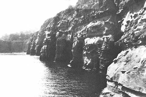
Figure 71a
View looking east at Goldfish Point, LaJolla, 1916. Note the unique development of the
caves for this part of the coast. They have presumably formed through a combination
of marine and solution erosion along pre-existing fractures.
Photo : SIO Archives.
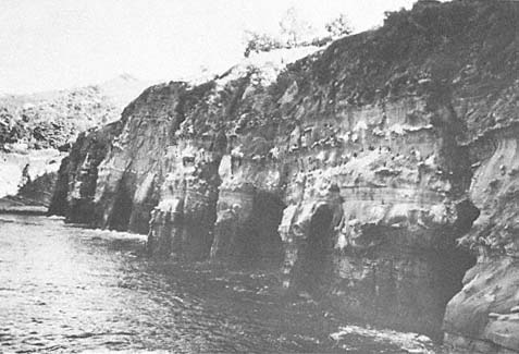
Figure 71b
View of the same site as that in 71 a , 1978. Note that very little change is evident.
Photo : F. Shepard.
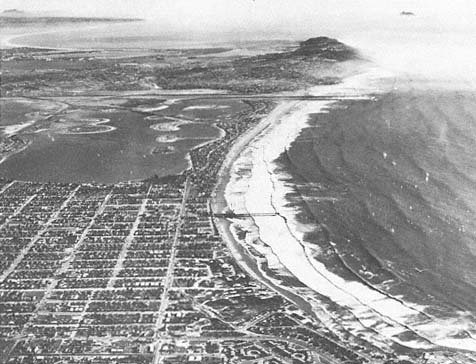
Figure 72
Early 1950s view looking south across Pacific Beach, Mission Beach, Point Loma, and
into Mexico. Note the Mexican Coronados Islands offshore in the upper right of
the photo.
Photo : F. Shepard.
Cove (figs. 71a , 71b ), one of the few protected swimming areas along the coast. Farther south, the point recedes but continues to be rocky with relatively low terraces and is indented by a few coves with steep, sandy beaches which derive their coarse sand from the local cliffs (fig. 72).
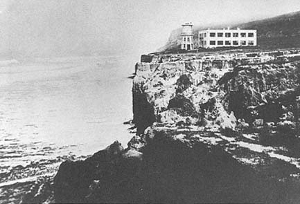
Figure 73
View of the original Scripps Building and water tower, SIO, 1910. Note the
absence of a talus at the base of the cliffs, indicating active wave erosion.
Photo : SIO Archives.
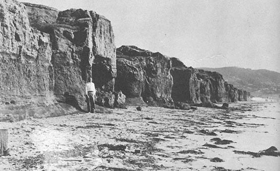
Figure 74a
View of low-lying alluvial cliffs south of Scripps, 1936. Cliffs were retreating at that time at a rate of about
one foot per year.
Photo : U. S. Grant IV.
Alluvial Cliffs Near Scripps Institution
We have considerable knowledge of the history of the alluvial cliffs at the northern end of the La Jolla section of coast. The first buildings of the Scripps Institution were located just a few feet inside this terrace (fig. 73). Apparently the builders did not realize that this area was subject to rapid retreat, on the order of a foot or more per year, as was established by repeated measurements (Vaughan 1932). This was actually known earlier than Vaughan's work because seawalls had already been constructed in front of the Scripps buildings (Hanna 1926:233); nonetheless, retreat continued north and south of the wall until about 1946.
The erosion was found to be related to the fact that the sand beach was several hundred feet wide at low tide in the summer and was subject to depletion during winter storms (Shepard and Grant 1947). Generally the erosion began as a series of sand cusps, after which the waves completely removed the sand from the beach to expose underlying gravel and sometimes the underlying semiconsolidated alluvial formation (fig. 74a ). During late winter storms, this allowed the waves, with the help of cobbles, to undercut the alluvial cliffs and thereby produce the annual retreat. Beginning in 1946, however, the storms became less violent, and the beaches were not appreciably cut away in the winters, so the smaller waves that reached the cliffs were not capable of undermining them. Instead, over the next thirty years, most of the bluffs gradually became less steep, and vegetation became well established on the slopes. Only an occasional storm did any cutting, and then it was at the cliff base.
As a result, the builders, who rarely show interest in anything that may have happened more than a few years in the past, began building homes all along these apparently stable bluffs and filled canyons, some even extending support columns out over the inner beach. This practice was curtailed by the California Coastal Commission, however, in the 1970s.
In January 1978 the first severe storms in thirty years occurred and panic followed (Kuhn and Shepard 1979b ). Desperate measures of all sorts were tried in an effort to stop the erosion of the alluvial bluffs, which had been postponed for so long. In one threatened area, the homeowners obtained old cars and drove them onto the beach, hoping they would buffer the cliffs from the waves (fig. 74b ). The cars were soon smashed to pieces, posing little resistance to the high surf and leaving a pile of glass and steel frames on the beach. The steel frames were removed by the homeowners, and concrete was poured over riprap in another attempt to stop the waves (fig. 74c ), but the waves broke over the existing concrete wall, causing it to collapse (fig. 74d ) and greatly accelerating erosion of the adjacent property (fig. 74e ).
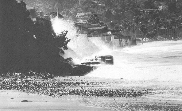
Figure 74b
January 1978 view at the same location as that in 74 a . A long, benign period with little erosion had just ended
with the severe storms of 1978. Note the remnants of old automobiles which were driven onto the beach
in an attempt to stop renewed erosion.
Photo : G. Kuhn.
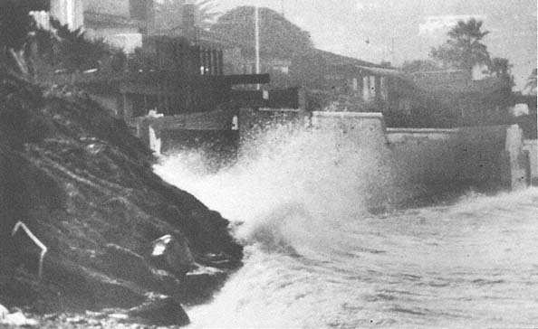
Figure 74c
February 1978 view at the same location. Automobiles have been removed from the beach, riprap was placed along
the slope toe, and the slope face was covered with gunnite.
Photo : G. Kuhn.
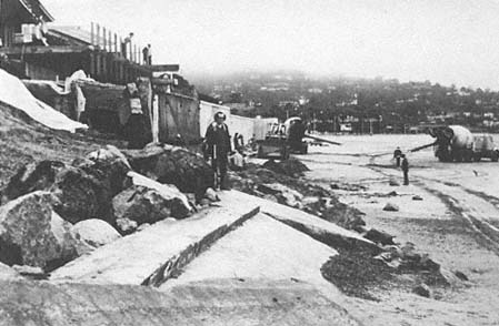
Figure 74d
February 1978, same location. Note the partial seawall collapse.
Photo : G. Kuhn.
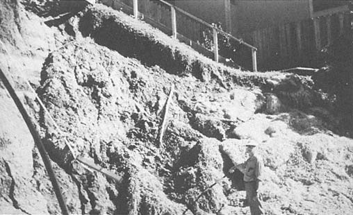
Figure 74e
March 1978 view at the same location. 1978 storms produced local retreat of fifteen to eighteen
feet in this general area.
Photo : G. Kuhn.
Elsewhere seawalls were begun. This method, however, was only partially successful, as some collapsed while being built. As this book is being written, most of the homes are protected by a substantial, continuous seawall (fig. 74f ), and only one small section at Scripps Institution remains unprotected. This last site is now being threatened, as evidenced by a number of cracks that became visible in the winter of 1982 in the pavement of the parking lot there. These cracks have since been filled. During the large storms of January to March 1983, however, the alluvial cliffs retreated about three feet as a result of cobble abrasion, and the Scripps wooden stairs collapsed, necessitating their closure for public safety.
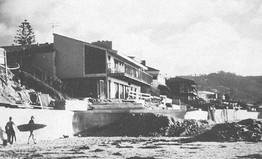
Figure 74f
October 1979 view at the same location. Victory achieved at a considerable expense: an almost
continuous seawall constructed along the cliffs.
Photo : G. Kuhn.
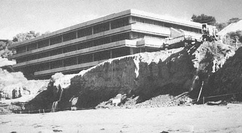
Figure 75
View of the recently constructed Marine Biology Building at SIO, 1979. Note that the cliff
had retreated approximately fifty-six feet since 1912.
Photo : G. Kuhn.
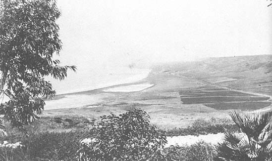
Figure 76
The unmodified lagoon shoreward of the La Jolla Submarine Canyon as it appeared in 1930.
Photo : F. Shepard Collection.
One of the last sections to be protected by a seawall was the Marine Biology Building at Scripps (fig. 75). This was a sore point with university architects who located the building on a low terrace of alluvium, about fifteen feet from its cliffed margin. They apparently failed to utilize studies showing that this margin had retreated some fifty-six feet over a sixty-three-year period from 1912 to 1975 (Hannan 1975). They even graded the outer terrace, which added to the erosion potential, and allowed pipes that drained water from the laboratories of the building to run out under the building margin, which only further eroded underlying semiconsolidated rock formations. The results should have been anticipated. The terrace margin was cut away during the first year the building was occupied, and serious sagging of the floor occurred. A seawall was then built, and other measures were taken to prevent further damage to the new building. Just north of the building, over fifty Indian burial sites have been uncovered in the cliffs. Carbon-14 dating shows them to be from 5,460 to 7,370 years old (Shumway et al. 1961). A fossil horse bone found directly south of the building yielded an age of 55,000 years as determined by amino acid (Bada et al. 1974).
A curiosity observed in the beach north of Scripps Institution pier is the long, concretionary rock extending out from the shore. It forms a sort of dike that is well exposed each winter, when the sand is cut away from either side. Photographs dating back to 1943 show that erosion has gradually removed the outer portion of the concretion and, as blocks became detached, they were ground into sand (Emery and Kuhn 1980). South of the alluvial cliff zone is a barrier beach. It continues for more than half a mile, where it terminates south of the beach club in the sandstone cliffs. There is evidence that a considerable lagoon once existed inside this barrier, as indicated from soil foundation cores and from the fact that the lower part of the old lagoon became submerged in heavy rains (fig. 76). Extensive artificial infilling occurred during the recent dry decades, and a portion of what is now known as La Jolla Shores was created. This lagoon was partly filled by the runoff from Hidden Valley. There are
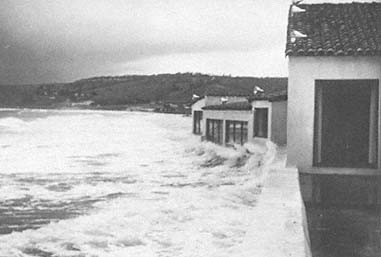
Figure 77
January 1949 photo of waves breaking against the Marine Room, La Jolla
Shores. Much more extensive damage occurred during the
stormy winter of 1982–83.
Photo : F. Shepard.
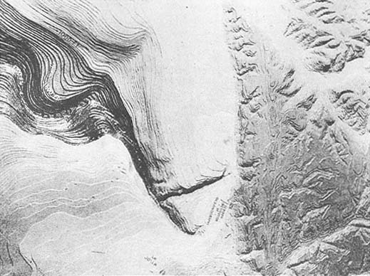
Figure 78
Locations of the La Jolla and the Scripps Submarine Canyons offshore at La Jolla, and their
relation to the land canyons. From Shepard and Emery 1941.
indications that at one time a barrier also existed at a somewhat higher level, to the north, as can be observed by the small terrace level when following the road south from Scripps Institution. The Marine Room Restaurant at the La Jolla Beach and Tennis Club was damaged by several storms in the 1940s (fig. 77) and sustained extensive damage again in 1983.
Submarine Canyons off La Jolla
The La Jolla coast is somewhat unique in having two submarine canyons that extend virtually in to the beach (fig. 78). One of these canyons is located off the cliffs north of Scripps Institution, and the other is off the south end of the long beach at La Jolla Shores. Both canyons are rather clearly related to the land valleys at their heads. The northern one, Scripps Canyon, extends southward in an almost straight line and has vertical, and even overhanging, walls all along its length for about a mile out, where it joins the less precipitous La Jolla Canyon. One unique feature of Scripps Canyon is its constantly changing depths. It fills gradually for a number of feet, and then a slide, sometimes combined with a turbidity current, carries the sediment seaward, often with enough force to remove large boulders along its course. It has several side canyons at its head and, from time to time, new or old buried tributaries are apparently uncovered, which may subsequently be refilled.
La Jolla Canyon has steep sides and a vertical headwall but is generally less precipitous than Scripps Canyon. It extends for thirty-three miles seaward in a general southwest direction and enters San Diego Trough twenty-seven miles off the coast at a depth of 3,600 feet. Dives into the head of the canyon show it to be unstable, and the character of the bottom changes at frequent intervals of time. The surrounding terrace has yielded many artifacts, some dated at approximately 4,200 years old. There is substantial evidence that the head has been retreating shoreward at an average rate of about one inch per year for the past few thousand years (Shepard and Dill 1966:57–58). Shepard and Dill (1966) also showed that the retreat from 1950 to 1964 was over two feet
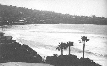
Figure 79
View looking south toward La Jolla Shores, 1978. Note that the
rip currents can be seen in the center of the photo. They form
between the lowest and the highest waves near the La Jolla
Submarine Canyon.
Photo : G. Kuhn.
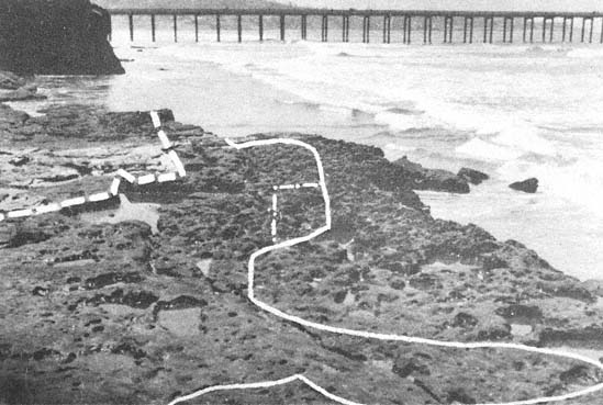
Figure 80
Sea cliff retreat by removal of the joint blocks of the sandstone bed in the lower-middle Eocene Ardath
shale that caps a bench projecting from the sea cliff 300 feet north of SIO pier; the top is about seven feet
above high-tide level. The sequence of retreat at the edge of the sandstone capped bench: July 1940, May
1944, June 1953, and July 1979. Maximum retreat was twenty-three feet in forty years, but none of the
blocks remain at the foot of the bench front. From Emery and Kuhn 1980.
per year. An interesting feature of La Jolla Canyon is the effect it has on the waves on the long beach at La Jolla Shores. The waves are almost always much smaller at the head of the canyon, owing to wave divergence as the crests move shoreward up the canyon. Conversely, they are much larger at the north end of the beach where the waves converge, so there may be two-foot breakers at the canyon head and ten-foot breakers in the northern convergence, half a mile up the beach. Thus, swimming is easier at the canyon head, and huge numbers of bathers swim there every day in the summer, whereas surfers are relegated to the northern convergence, where they abound. The effects also relate to the rip currents which are an ever-present danger. These rips are in the area between the lowest and highest waves, and the lifeguards are on constant alert for unwary bathers in this zone (fig. 79).
Rose Canyon Fault Zone and Change in Coastal Configuration
South of La Jolla Shores one encounters the seaward continuation of Mount Soledad. The relatively low cliffs, just south of the beach club, are of cretaceous sandstone and are bordered seaward by a wide wave-cut terrace that shows at low tide a series of small hog-backs made by erosion of the tilted strata. This is an amazingly wave-cut terrace rock and is unique, so far as we know, along the San Diego County coast; although rock terraces do exist in other places, they are not quite so exposed at low tide.
The history of the area poses an interesting question. So far as we know from available literature, it should take a long time, on the order of several thousand years, to form such a terrace with its low, hog-back ridges. This suggests a relatively long period of stability for the site. However, the terrace may be cut away rather rapidly, as shown by the measurements made in Eocene sand and shale just north of the Marine Biology Building at Scripps Institution (fig. 80) (Emery and Kuhn 1980). Yet we seem to be considering an area of little
stability; certainly the uplifted terraces extending 800 feet to the top of Mount Soledad do not suggest long-term stability.
Just south of the tidal terrace, there is a fault coast continuation of the north scarp of Mount Soledad. In fact, this terrace clearly dips down at its southern end before encountering the east-west sandstone cliffs of Cretaceous age at its southward termination. One would expect the Cretaceous terrace rock, which is older than the Tertiary, to be bent to the south by the faulting at the base of Mount Soledad, but this is not the case. The cliffed north side of Point La Jolla, with its sandstones and deeply penetrating caves, was probably the place for which the town was named: la jolla comes from the Indian phrase meaning "hole in the ground." (The old interpretation of the name to mean "the jewel" was possibly an invention of the original chamber of commerce.) It is curious that such caves exist in a sandstone formation. It does not seem reasonable that they are the result of wave erosion alone. If they were, there should be a wave-cut terrace at their base, but the only terraces are somewhat below the base. It does not seem likely that waves could have extended deep into this sandstone with any erosive power. It is more likely that some type of solution of the sandstone cement is involved below groundwater level. Thus, we have the same puzzle that was encountered in the caves under Solana Beach to the north, where there appear to be caverns deep below the surface that may connect with the caves found along the shore, the latter being clearly related to wave erosion.
Sea Arches and Stacks at Point La Jolla
Erosion of the bluffs at Point La Jolla pose an interesting problem. Examination of the formations and their concretions at the west end of the bluffs and a comparison of their present condition with photographs taken in about 1900 show a conspicuous lack of appreciable erosion (figs. 81a , 81b ). One arch at Goldfish Point has shown very little change since 1908 (figs. 71a , 71b ). The
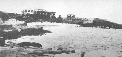
Figure 81a
Photo of La Jolla Cove, 1906. Two buildings were then located on the bluffs behind the cove. The
sandy beach is a favorite swimming spot.
Photo: Anonymous.
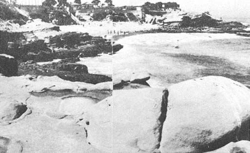
Figure 81b
April 1968 photo of the same site as that in 81 a . Note that the sandstone rocks in the foreground
show almost no change in sixty-two years, but the 1906 buildings have been replaced, and the
cove area is now a city park.
Photo: F. Shepard.
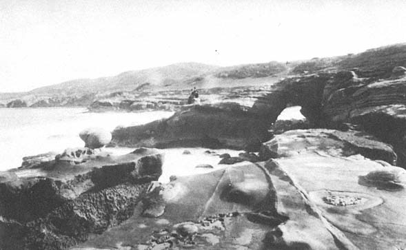
Figure 82a
View of Alligator Head arch, 1870. Note that many lineations and concretions are clearly identifiable in both
this and the following photo.
Photo: F. Shepard collection.
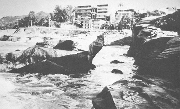
Figure 82b
View at the same location as that in 82 a , 1978. Collapse of the arch occurred during a storm in January 1978.
Photo: G. Kuhn.
same is true of some massive boulders of concretionary appearance a little to the west near La Jolla Cove, which apparently are on the edge of a rock terrace exposed to large converging waves formed by Alligator Head. Furthermore, old pictures of the cove west of the cliffs show decided changes in the well-known arches which existed in the early part of the century and which were partially reinforced with cement in later years. They finally collapsed, the last one falling in 1978. The outer part of Alligator Head has also changed since early photographs were taken around 1870 (fig. 82a ). This arch also collapsed in 1978 (Shepard and Kuhn 1983) (fig. 82b ).
Figure 83a
Boomer Beach west of La Jolla Cove, sometime in the 1940s. Seasonal change occurs
as the result of the different direction of wave approach and the heavier winter surf.
This photo shows summer conditions; waves from the south have built a beach at the
north end and have taken sand away from the south end.
Photo: F. Shepard.
Figure 83b
The same location as that in 83a , taken sometime in the 1940s. This view shows the winter
conditions when heavy surf from the northwest has removed the beach shown in 83 a and
carried sand to the south, creating another, smaller beach on the right in the photo.
Photo : F. Shepard.
Boomer Beach, just south of Alligator Head, is interesting to watch for seasonal changes. It consists of a coarse sand beach with a steep frontal slope during summer months (fig. 83a ) but, with the first winter storm, the sand is washed away to expose underlying boulders (fig. 83b ). The sand apparently is carried partly to the south, forming narrow beach fringes, and some is carried seaward. However, with the onset of summer and the south-approaching waves, the sand returns to Boomer Beach, and the narrow fringes to the south disappear.
Most of the relatively straight, rocky coast extending toward the Children's Pool had had little erosion since the 1930s until the storms in January through March 1983 caused many large cracks to develop. At the Children's Pool, also known as Casa Pool, there is a jetty built out from a rocky point, partly enclosing a cove. It was thought that by putting large holes in the south end of the jetty, any sand that was carried into the enclosure could be washed through, keeping the pool open. This did not work, however; the holes soon became blocked, and the pool was filled with sand, leaving at the north end only a narrow semicircle of water. Farther south, there was a rocky point with some breaks in its continuity
Figure 84a
View of Cathedral Rock Arch, La Jolla, 1873.
Photo: F. Shepard collection.
Figure 84b
October 1963 view of the same site as that in 84 a . A remnant is all that is left of the
buttress at Cathedral Rock. By 1968 this remnant had also disappeared.
Photo: F. Shepard.
and a beautiful arch called Cathedral Rock on its west side (fig. 84a ). The arch collapsed in 1906 and, when Shepard first photographed the site in 1934, the buttresses of the old arch were still standing, as were other rocks that have since gradually disappeared; now every remnant of the arch is gone (fig. 84b ). Many sections of the partially submerged rock point have been removed as well, so that the entire coast south of the Children's Pool has changed extensively since the first photographs were taken of this area.
Still farther south is Windansea Beach where body surfers find excellent wave conditions for riding the surf. We have some photographs dating back to 1934 which show some interesting changes. There was a natural bridge, apparently cut in a surge channel and exposed only when the sand was cut away
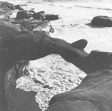
Figure 85a
View of arch at Windansea Beach, La Jolla, 1952.
Photo: F. Shepard.
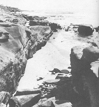
Figure 85b
Summer view after Windansea arch collapsed, 1968.
Photo: F. Shepard.
from the sandstone during winter storms (fig. 85a ). This arch collapsed sometime in the 1950s (fig. 85b ). It is interesting that the sand shifts to the south during the winter months and to the north during the summer, as at Boomer Beach. Again, there is more sand during the relatively small waves of summer. Sea cliff retreat was observed by lifeguards one-half mile south of Windansea Beach during January 1983. Other parts of this rocky coast that have not been studied are probably also retreating. It is known, however, that erosion was occurring at the foot of Marine Street just before Christmas of 1940 during a period of large waves. The small bluff in front of the Revelle house near Windansea Beach was being eaten away by these waves when Shepard and Revelle returned from a cruise to the Gulf of California on December 23 of that year. Erosion was halted by dumping large boulders at this point; a seawall later was constructed by the Revelles. This was the same storm that cut away the talus at the base of the cliffs that terminate north of La Jolla (Kuhn and Shepard 1979a ). One wonders what conditions of the early 1900s allowed the development of sea arches in these resistant rock units. Only one arch is being formed at present, so far as we know, and all the old ones have disappeared (Shepard and Kuhn 1983).
South of La Jolla the cliffs and terraces are of much softer rock, and beyond the Bird Rock area they are largely alluvium. One house there had a porch extending out to the edge of a shale cliff, but in 1965 the porch collapsed when the underlying cliff failed. At Bird Rock, a stack standing above the tidal terrace showed little erosion during the past few decades, up until January 1963, as documented through photographs. The low alluvial cliffs, however, are actively eroding, although the rate has not been established.
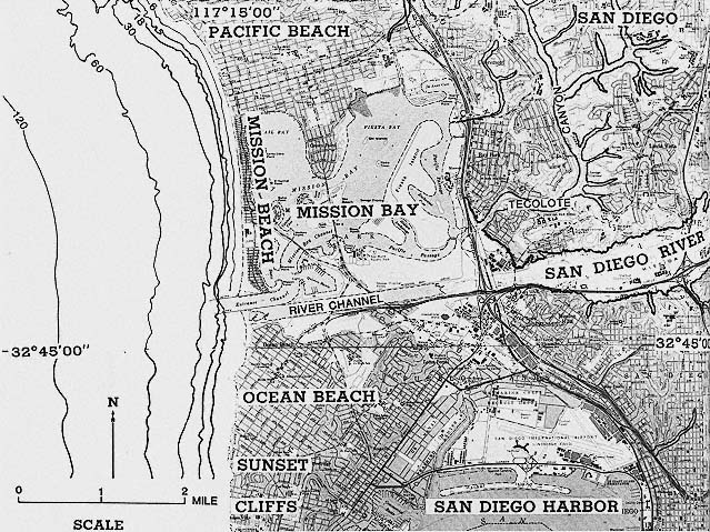
Figure 86
Location map of Pacific Beach, Mission Beach, and San Diego Bay and River.