Blacks Beach Landslides
Blacks Beach (now Torrey Pines City Beach) has vertical and near-vertical cliffs over 350 feet high. During the summer, as many as 50,000 people may be on the beach at one time. For many years Blacks Beach was the only legal nude beach in southern California, and even today the practice is not entirely eliminated. It is fortunate, considering the large numbers of sunbathers, that few landslides have occurred in recent years. In the past, Blacks Beach has apparently experienced very large landslides, as noted by Sumner and Ross (1930). They described a failure between 1917 and 1922 with dimensions of 450 feet along the shore, 175 feet to the base of the cliff (75 or 100 feet wide higher up), and approximately 200 feet of the vertical cliff face. Prior to 1940, a large talus buildup allowed access to a hanging valley. During the storms at the end of 1940, this talus was completely removed (Kuhn and Shepard 1979a ) and was not reconstituted until about 1970.
In February 1982, a massive landslide occurred at this same location, measuring approximately 750 feet along the cliff by 280 feet into the cliff (fig. 67). This slide carried material, including large boulders, across the beach to the water, cutting off one side of the beach from the other except at low tide. The fallen material comprised acres of sandstone and provided a large future source of sand for the beach. Prior to this movement, groundwater was seen on the cliff face, and tensional fractures were noted along the top by San Diego city lifeguards. A local engineering geology firm, Leighton and Associates (1981), had completed a reconnaissance study of the area in May 1981 and had mapped an existing old landslide at the site. At the time of their report, fractures existed farther back from the landslide head scarp, indicating sections of future failures.
The 1982 landslide occurred during a very benign winter with little rainfall and few storms. Interestingly, on the evening prior to the cliff collapse, the seismograph at Scripps Institution of Oceanography registered a surface wave, with no earthquake being reported. It therefore appears that collapse of this
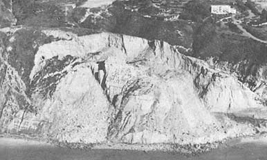
Figure 67
Landslide at Blacks Beach north of Scripps Institution of Oceanography
(SIO) which occurred January 29, 1982. Note the recent slide material on
the beach and the fresh vertical scarp behind the slide.
Photo : Ron McConnaughey.
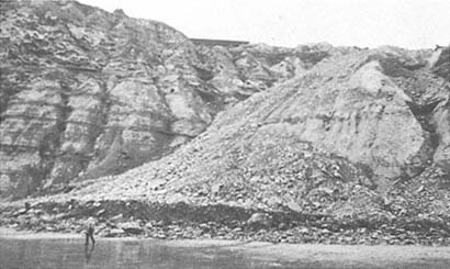
Figure 68
February 1978 view of the fall of 1977 landslide debris along the cliffs in front
of the former Drell residence.
Photo : G. Kuhn.
slide was forthcoming, as the earth shock indicated that a major section had broken loose. In 1977, before the heavy rains of 1978, a landslide occurred directly in front of the former Drell residence in the La Jolla Farms area (fig. 68) (SCT Consultants 1979). This slide included approximately forty-five feet of the yard on the seaward side of the house, and debris from the slide reached far across the beach below.
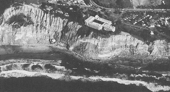
Figure 69a
March 1978 oblique aerial view of the National Marine Fisheries Building. Note the funicular tram built at a
precarious position north of the building, and the rockfall directly in front of it. An old landslide was
discovered to be under the building after it was constructed.
Photo : G. Kuhn.