Sherpas
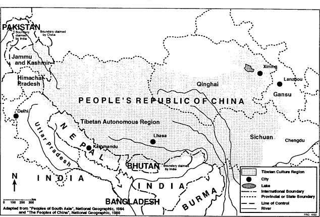
The Sherpas are one of a number of peoples of Tibetan origin and cultural affinities who have migrated south to settle the northern regions of the Himalaya. In Nepal there are several such peoples who inhabit the Great Himalaya, the trans-Himalayan valleys of western and central Nepal that lie between the Himalaya and the Tibetan plateau, and some parts of the midlands. These peoples are part of a much larger population of more or less ethnically Tibetan peoples who number more than six million and who occupy a territory of more than two million square kilometers stretching from the Chinese provinces of Gansu, Sichuan, and northern Yunnan across Tibet to Ladakh, from China's Qinghai province south to the southern slopes of the Himalaya, and along the full length of the Himalaya from Arunachal Pradesh to Kashmir. Across this Tibetan culture region (map 3) there are scores of peoples whose languages, religions, systems of social organization, economies, land-use practices, architecture, and styles of dress and ornamentation share strong resemblances. These similarities include Tibeto-Burman languages closely related to Tibetan; adherence to sects of Tibetan Buddhism; domestic and religious architecture featuring white, stone-walled structures with characteristic window patterns and other distinctive features; settlement sites at altitudes of more than 2,000 meters; cultural preferences for raising yak, sheep, and barley; distinctive traditional woolen dress consisting of a black or brown, extremely long-sleeved cloak for men and a dark, woolen dress with a striped apron for women; and special value put on certain types of jewelry, including silver amulet boxes and necklaces featuring coral, turquoise, zi stones, and silver.[23]
In Nepal peoples who have Tibetan-like oultures inhabit more than a quarter of the land area of the country. They comprise only a very small part, however, of Nepal's population of eighteen million.[24] Those who
Map 3.
The Tibetan Culture Region
live closest to the Tibetan border and most closely resemble the Tibetans in culture constitute less than 1 percent of Nepal's population. These peoples, among them the Sherpas, are sometimes referred to as Bhotes or Bhotias.[25]
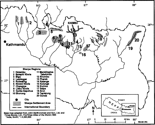
People who call themselves Sherpas inhabit much of northeastern Nepal between the Sun Kosi and Arun rivers and form a part of the population of several other areas as far west as the Helambu (Yelmo) region northeast of Kathmandu and perhaps as far east as the Sikkim border.[26] The heartland of Sherpa country is the upper Dudh Kosi valley and the valley of one of its major tributaries, the Solu Khola. Often known as Solu-Khumbu, this region according to legend was the first area settled by the ancestors of the Sherpas after their migration from Tibet some nineteen generations ago. It remains the main population concentration of Sherpas today, with approximately 17,000 of what may be a total of 20-25,000 Sherpas in Nepal and as many as 30,0000 in the Himalaya as a whole.[27] This core population inhabits several geographically distinct territories that also vary to some degree in culture. The three most important of these in terms of area and population are Khumbu, Pharak, and Shorung, all of which are located in the Solu-Khumbu district of eastern Nepal. Despite their close proximity these three regions differ considerably in altitude and topography, spanning the full altitudinal range of Sherpa settlement. The Sherpas of Khumbu inhabit the rugged Great Himalayan highland valleys in the headwater region of the Dudh Kosi valley, their lands virtually all above 3,000 meters. Pharak is south of Khumbu in the Nepal midlands reaches of the Dudh Kosi valley. Here villages are situated between 2,300 and 2,800 meters. Shorung is located west of Khumbu and Pharak and reaches from the hill country of the Nepal midlands to the Great Himalaya. According to some Sherpas' reckoning it includes the Manidingma region of the west bank of the Dudh Kosi as well as the valley of the Solu Khola and the interfluvial uplands. Shorung villages vary in altitude from approximately 2,000 to 3,000 meters. Differences in the topography, climate, and vegetation of these three areas have supported very different economies based on differences in seasonal, altitudinal land use and associated variations in agricultural and pastoral practices and forest exploitation.
The Solu-Khumbu Sherpas, and particularly the Sherpas of Khumbu, are the Sherpas who have won worldwide admiration for their strength, endurance, courage, indomitable good spirits and joy in life, deep faith in Buddhism, and their relatively egalitarian and open society. Khumbu Sherpas initially earned their world renown through reports of their mountaineering exploits during the first half of this century. Their reputation was built especially on their performance on the series of British expeditions to Everest. Sherpas had become legendary in mountaineering cir-
cles by the 1920s when the British began awarding the finest climbers among them the title of Tigers. But relatively little was known about their homeland and culture even as late as 1953 when Tenzing Norgay and Sir Edmund Hillary reached the summit of Everest, an event which made Sherpa a household word around much of the planet.[28] Foreigners had been banned from traveling to Khumbu until 1950, when the Nepal government began to relax the policies that had previously made Lhasa more accessible to foreigners than the highlands of Nepal.[30] It was only in autumn 1950 that the first small group of British and American mountaineers was permitted to make the long journey on foot to the southern foot of Mount Everest and experienced for the first time the alpine grandeur of the Khumbu valleys and the generous hospitality of the Sherpa villages. Other mountaineers soon followed in a steady stream of expeditions and were joined by journalists, scientists, cartographers, the Hillary schoolhouse and hospital building teams, and finally in the 1960s by ordinary tourists. Sherpas also attracted considerable anthropological attention. One of the most distinguished anthropologists of South Asia, Christoph von Fürer-Haimendorf, conducted the first ethnographic studies of Khumbu Sherpas in 1953 and 1957. Fürer-Haimendorf's classic monograph, The Sherpas of Nepal (1964) and his later, more detailed treatment of the Sherpa economy and its changes between 1957 and 1971 (1975) focused primarily on Khumbu Sherpas and provided a firm ethnographic base for subsequent, more specialized anthropological and geographical Sherpa studies. Anthropologists have examined Khumbu Sherpa population dynamics (Pawson, Stanford, and Adams 1984), ethnohistory (Ortner 1989), religion (ibid.), shamanism (Adams 1989), festivals (Jerstad 1969), and the regional socio-economic and cultural changes that have accompanied tourism development and the establishment of such new institutions as schools and Sagarmatha National Park (J. Fisher 1990).[30] Geographers have also contributed to the increasing body of writing on Khumbu land and life with accounts of exploration and travel (Gurung 1980; Jackson 1955) and studies of geomorphology (Byers 1986, 1987b), natural hazards (Zimmerman, Bichsel, and Keinholz 1986), vegetation change (Brower 1987; Byers 1987b; Stevens 1986b, 1989), erosion (Byers 1987b ), pastoralism (Bjønness 1980a ; Brower 1987; Palmieri 1976; Stevens 1989), tourism impacts (Bjønness 1980b , 1983; Stevens 1988b , 1989), and cultural ecology (Stevens 1989).[31] Although most anthropological and geographical research has focused on the Sherpas of Khumbu, there have also been a number of studies of the Shorung Sherpas (including Funke 1969; Kunwar 1989; March 1977; Oppitz 1968, 1974; Ortner 1978, 1989; Paul 1979, 1982) and some work on other groups including the Rolwaling Sherpa (Kunwar 1989; Sacherer 1975, 1981), the Chyangma Sherpa (Limberg 1982), the Sherpas of the Bigu region (Fürer-Haimen-
dorf 1984; Kunwar 1989) and the multiethnic valleys of the Helambu region (N. Bishop 1989; G. Clarke 1980a , 1980b ).
From an anthropological perspective Sherpas have been widely characterized in terms of such fundamental features as language, clan structure, religion, and shared history. They have been classified as racially Mongoloid, linguistically Tibeto-Burman, and culturally "Bhotia" or "Tibetan" in terms of general orientation and origins.[32] On the basis of these basic traits the Sherpas of Solu-Khumbu can indeed be readily distinguished from neighboring non-Sherpa Tibetan, Rai, Gurung, Tamang, Sunwar, and Magar groups: Solu-Khumbu Sherpas speak Sherpa, a language distinct from the languages of these other peoples and from the national language, Nepali, which is a member of the Indo-European language family. They belong to one or another of a certain set of exogamous patrilineal clans. They believe in Tibetan Buddhism and specificially are adherants of the Nyingmapa sect. And they are descended (or at least some core of their clans trace their descent) from a small set of immigrant families who came to Nepal from Tibet more than four centuries ago.
Khumbu Sherpas distinguish themselves from the neighboring peoples they call Dongbu (Rai and Gurung), Rongba (Nepali), Tamang, and Pürba (Tibetan).[33] Usually they draw these contrasts on the grounds of territorial homeland, language, religion, and social structure.[34] While these attributes are the ones most often raised as central facets of "Sherpaness," a number of other characteristics are also often mentioned. Many Khumbu Sherpas talk of Sherpas (by which they actually usually mean specifically Khumbu Sherpas) being distinguished from other peoples by such things as their houses (including details such as materials used, styles of wall, window, and roof construction, and the placement and design of the roof, window, and house-pole prayer flags), clothes (including the cut of women's dresses and the style of their aprons), regional, village, and household festivals and rites (Dumje is especially cited, while Losar, Yerchang , and Pangyi are also mentioned), community offices through which temples, festivals, and natural resources are managed, and styles of livelihood and land use.[35]
Sherpas are undoubtedly most closely culturally related to their neighbors to the north, the Tibetans, with whom they share many cultural features. Their languages are closely related. While Sherpa, unlike Tibetan, is an unwritten language (and hence the considerable confusion over its orthography), it has a similar structure of Tibetan and according to one estimate may have 50 percent cognates with central Tibetan (Hutt 1986:17).[36] Sherpa social structure, like that of Tibet, includes both nuclear and stem families and accepts polygamous as well as monogamous marriage.[37] Like the people of at least some parts of Tibet, Sherpas trace their lineage and choose their spouses with reference to their affiliation in
exogamous, patrilineal clans.[38] They follow a Mahayana form of Buddhism developed in Tibet (Vajrayana or "Tibetan" Buddhism) and more specifically adhere to the Nyingmapa or "Red Hat" sect developed in Tibet in the eighth century.[39] As in Tibet there is respect also for divinities and powers in the natural landscape such as yul lha (regional mountain gods) and lu (spirits of springs and trees). Sherpa domestic and religious architecture are closely related to Tibetan styles.[40] In some though not all Sherpa regions, as in Tibet, there is a preference for raising yak and barley. Sherpas also share with Tibetans some taste in clothing and personal ornamentation as well as many other customs and beliefs.
Such similarities are not surprising considering the relatively recent migration of Sherpas to Nepal and the way in which—in Khumbu at least—continuing Tibet immigration has constituted a major component of nineteenth- and twentieth-century population growth. Close cultural contact between Khumbu and Tibet has also been maintained by trade, pilgrimage, the custom of devout Sherpas going to Tibet for religious instruction, and Khumbu's long appeal to Tibetan monks as a place for meditative retreat or careers as village lamas. Together this high level of interaction may have contributed to the greater "Tibetaness" that some other Sherpas find characteristic of the Khumbu Sherpas. There may also have been political links at one time between Khumbu and Tibet. There are oral traditions of taxes paid to Tibet in the early nineteenth century. People point out the former site in Nauje of the house of one of these tax collectors, and near Nauje is a ruin which is considered to have been a Tibetan fort (dzong ) that is said to have been overrun by Nepalese forces during the 1855-1856 war between Nepal and Tibet.[41]
Even though all Sherpas have strong historical and cultural ties to Tibet, both they and their Tibetan neighbors consider Sherpas to be a distinct people. During nearly twenty generations of life south of the Himalaya Sherpas have combined a heritage brought from Tibet with their own inspirations, developing a culture distinctively their own. They point out a number of basic differences between themselves and Tibetans. Sherpa is a distinct language. Sherpas have their own local gods, spirits of places, clan gods, and regional gods. They celebrate distinctive religious festivals such as the major summer celebration of Dumje held in Khumbu, Shorung, Dongritenga, Golila, and Rimijung in Pharak. Sherpa clans are for the most part different from those of Kham; all but two of the more than twenty clans recognized by Solu-Khumbu Sherpas are believed by them to have been developed after their arrival in Nepal. Some life-cycle rites are different. There are differences in vernacular architecture. Sherpa and Tibetan land use (at least the land use characteristic of the adjacent Tingri region) also varies. In most Sherpa regions, including Khumbu, yak and sheep are not as important as they
are in Tibet. In some Sherpa areas, again including Khumbu, yak-cattle crossbreeds are raised, contrary to the practice followed in Tingri and some other parts of Tibet where there are religious reservations against such breeding. And while Khumbu Sherpas, like Tibetans, prize barley, they give it a much less important role in their agriculture and diet and emphasize buckwheat and tubers more.
Sherpa Regions
People who identify themselves as Sherpa and are recognized as such by other Sherpas and their non-Sherpa neighbors inhabit a considerable part of the highlands between the Sun Kosi and the Arun rivers, land that today falls within the administrative districts of Solu-Khumbu, Dolakha, Ramechap, Olkadunga, Sankhuwasabha, and Khotang. There are apparently also Sherpa villages west of the Sun Kosi in the upper Balephi Khola valley (Sindhupalchok district), and people who claim descent from these (and possibly other Sherpa-inhabited areas) also form a component of the multiethnic population of the Helambu region of Sindhupalchok just to the northeast of the Kathmandu valley.[42] Sherpa settlement as far west as the Sun Kosi and as far east as the Arun river can be related to migrations from Solu-Khumbu as recently as the nineteenth century.[43] As previously mentioned, there are also Sherpas in the Darjeeling district of the Indian state of West Bengal, the descendants of Solu-Khumbu emigrants who were attracted in the late nineteenth and the first half of the twentieth centuries to economic opportunities there (particularly to mountaineering and porter work).[44] The inhabitants of a number of high-altitude settlements in the far northeast corner of Nepal near Taplejung (including the village of Gunsa) are also often referred to as Sherpa (Bremer-Kamp 1987; Sagant 1976). Fürer-Haimendorf suggests that these families migrated from Shorung (1984:3). In the late nineteenth century, while traveling through that region, Sarat Chandra Das was "told that the upper part of the valley [of Kangpachan] was first inhabited by Tibetans called Sherpas, migrants from 'Shar Khumbu'" (Pradhan 1991:70).
Khumbu Sherpas consider themselves one of as many as twenty (depending on who is counting and his or her familiarity with outlying areas) different Sherpa groups in Solu-Khumbu district and the adjacent Dolakha and Ramechap districts to the west and Khotang, Bhojpur, and Sankhuwasabha districts to the east and three groups further afield. These regions are listed and shown in map 4.
Immediately to the south of Khumbu in the middle reaches of the Dudh Kosi (as far as the village of Surke and the Chutok La beyond it) is an area considered to be the homeland of the Pharak Sherpas. South of them are a group that some Khumbu Sherpas call Katangami, people of
Map 4.
Sherpa Settlement Area and Regions
Katanga, who live in and near the Sherpa-Magar village of Kharikhola. South of Kharikhola the eastern Dudh Kosi valley is inhabited by Dongbu (Rai in the north and Gurung in the Ra Khola tributary) and Rongba (Hindu hill castes). Farther to the east, however, there are other Sherpa settlement areas beyond the Pangkongma La in the Hinku Khola and adjacent areas including Kulunge, the Kurima area to the southeast, and Sanam, Share, and other small settlements near the Salpa Bhanjyang (pass). Still farther to the east there are Sherpas living in small settlements such as Murde, Kuwapani, and Hurhuri on the ridge-crest of the eastern slope of the Arun valley as well as at Tashigaon, Navagaon, Yangding, Shashiwa, and other places on several west-bank tributaries of the Arun and possibly at Yakua farther upstream.[45] The high country east of the Arun is inhabited primarily by peoples who settled there from Tibet in earlier times, but who are not directly related to Sherpas. The far northeast corner of the country, the Gunsa area northeast of Taplejung, however, is settled by people who may have at least some of their roots in Solu-Khumbu and who continue to make trading trips to Shorung today. West of the Dudh Kosi is more Sherpa territory. The area around Manidingma and Takshindo is sometimes referred to as Takshindo by Khumbu Sherpas who consider it different from Shorung proper. Shorung is considered to be the area from the ridge crest at Takshindo to the Lamjura pass and Pi Ke peak in the west, and from the high valleys at the foot of the sacred peaks of Numbur, Khatang, and Karyalong to the ridge south of the bend which the Solu Khola takes on its way east to the Dudh Kosi. Beyond Pi Ke and the Lamjura La there are three other Sherpa-inhabited regions east of the Khimti Khola watershed: the villages along and near the Likhu Khola, the village of Chyangma (which is jointly inhabited by Sherpas and Newars who settled there at least nine generations ago), and the villages of Golila and Gepchua. Farther west there are Sherpa villages near Jiri in the Khimti Khola region, Lambogar, Rolwaling, and the Bigu gompa (temple) area west of the Tamba Kosi. As already mentioned there may also be Sherpas as far west of the Sun Kosi as Helambu, although further research is needed to fully establish this. Khumbu Sherpas familiar with these various areas from trade, pilgrimage, and mountaineering and trekking work draw numerous contrasts between Khumbu culture and that of these other Sherpa groups.[46]
Khumbu Sherpas thus have a well-defined sense of themselves as distinct both from other Sherpas and non-Sherpa peoples. Yet the question of what and who are Sherpas, or even Khumbu Sherpas, remains complex. In recent years the fame, status, and economic opportunities of the Solu-Sherpas have sometimes led Tamangs (G. Clark 1980b ; Fricke 1986:30) and Rais (Fürer-Haimendorf 1984) to claim to be Sherpas in
order to obtain tourism work. In the Taplejung area some non-Sherpa high-altitude dwellers reportedly refer to themselves as Sherpas rather than as Bhotias when dealing with lower-altitude people as a way of affirming their Nepalese rather than Tibetan nationality. In the Arun region some people call themselves Sherpas who have no association with Solu-Khumbu while lower-altitude peoples in that region have begun to use the term Sherpa "as a generic term for all Tibetan-origin people" (Parker 1989:12). Within Khumbu itself there is even some confusion over who is and is not Sherpa. Khumbu Sherpas have long drawn a distinction between the older clans, the descendants of early settlers, and those who came more recently and have drawn a far sharper line between Sherpas and Khambas, the descendants of immigrants from Tibet and other Bhotia areas. Lacking membership in a patrilineal Sherpa clan, these immigrants were not only considered different from Sherpas but were treated with prejudice even though in Khumbu intermarriage with them was tolerated and took place.[47] This remains true today to a lesser degree. Khamba families intermarry freely with Sherpas, hold village offices, and are generally fully integrated into Khumbu society. Many now call themselves Sherpas and seem to be accepted as such within and outside of Khumbu. Further complexity is added by the fact that some of the central qualities by which Sherpas define themselves, as well as those by which outsiders distinguish them, have undoubtedly changed through time. Trading with Tibet, for example, was once an important aspect of Khumbu Sherpa identity, a quality which set them apart from Pharak and most Shorung Sherpas. Due to the decline in trade since the 1960s, however, this activity no longer distinguishes most Khumbu Sherpas from their neighbors.
For all the socioeconomic and cultural change of recent decades Khumbu Sherpas have not lost their sense of themselves as a people, and that to some important degree may be due to their having maintained their language, religion, social structure, and homeland. Territory is considered a fundamental aspect of identity. Khumbu Sherpas see themselves as the people who live in a particular group of four valleys on the border of Tibet. People who live beyond this region may be Sherpas, but are not Khumbu Sherpas even when, as in the case of the Pharak Sherpas, they may be culturally and socially very closely related indeed. Even the children of emigrant Khumbu Sherpas are often regarded as Darjeeling Sherpas, Shorung Sherpas, Kulunge Sherpas and so on rather than "Khumbuwa," people of Khumbu. It seems likely that the children of Khumbu Sherpas who have grown up in Kathmandu, speaking Nepali rather than Sherpa and living extremely different lives from their cousins in the mountains, will be considered to be "Kathmandu Sherpas" rather than Khumbu ones if they do not return to make their lives in Khumbu.
Finally, important facets of culture can also vary even among Khumbu villages. Local differences could be noted in such things as communal institutions and the conduct of festivals and village rites as well as in economic emphases.[48] Such variation cautions against generalizations about "Khumbu Sherpa" and "Sherpa" beliefs and practices on the sole basis of familiarity with the way things are done in a few settlements.
Population and Settlement Patterns
Most of the present population of Khumbu are Sherpas who are members of a group of "old clans" that trace their origins to the original Tibetan settlers of Solu-Khumbu. There are also substantial numbers of "new clan" Sherpas, a large percentage of Kamba families, and some families descended from unions between Sherpas and Gurungs, Tamangs, Newars, and Chetris.[49] Although they all consider themselves Sherpas there does remain some sense of social hierarchy based on these ethnic differences.[50] Besides these main components of Khumbu society there are more recent Tibetan refugees (about twenty-five families), a few households of lower-caste Hindu Kami blacksmiths (nine families) and tailors (two families), several upper-caste Brahmans and Chetri Hindu schoolteachers, two Tamang families, and a Magar family. There are also more than three hundred Hindu Nepalis stationed in the region with the police, army, post office, bank, Northern Boundary Commissioner's office, the government health post in Nauje, and the national park (Fürer-Haimendorf 1984:32). Scores of Rais, Magars, and Nepal midlands Sherpas also spend months or even years in Khumbu as household servants, agricultural laborers, fuel wood cutters, and stonecutters, and masons.[51]
Khumbu is unusual among Sherpa regions in the relatively high percentage of its population considered to be Khamba rather than of old or new clan Sherpa descent. This percentage varies regionally. Fürer-Haimendorf determined in 1957 that Khambas constituted 49 percent of the households of Khumjung, the region's largest village.[52] The percentage of Khambas in Kunde, Phurtse, and Pangboche was 33, 37.5 and 39 percent respectively (Fürer-Haimendorf 1979:26). In Nauje they were probably then a majority. For most purposes, however, there is no need to distinguish between Sherpas and Khambas and in this book I will do so only in the rare cases when historical and contemporary differences in land-use patterns and other economic activities need to be noted. Khamba families have all lived in the region now for several generations and differences between them and old-clan Sherpa families have diminished with time. Khambas intermarry with Sherpas, speak Sherpa, dress in Sherpa-style clothes, live in Sherpa-style houses, and participate fully
Table 1. Village Household Numbers and Population | ||||
Number of Households[*] | ||||
Village | 1957 | 1991 | Population (1979) | |
Nauje | 73 | 123 | 488 | |
Khumjung | 93 | 135 | 622 | |
Kunde | 45 | 50 | 237 | |
Pangboche | 58 | 83 | 347 | |
Phurtse | 63 | 62 | 287 | |
Thamicho | 192 | [**] | 707 | |
* The 1991 Nauje total includes four Zarok households. Ninety-four of the Nauje households and 125 of the Khumjung households were Sherpa or Khamba. The 1991 Pangboche figures include five Milingo-, five Changmiteng-, and five Dingboche-based households. The Thamicho total includes all households with main dwellings in the Bhote Kosi valley other than in Nauje. No household is tallied more than once, although some own houses in more than one main settlement. Only families who were resident in the area in 1991 were counted. Monks and nuns are not included in the population totals. | ||||
** A 1991 count of Thamicho households is not available. The complex settlement pattern of Thamicho makes it easy to double-count households. Fürer-Haimendorf's 1957 count may be high. | ||||
From Fürer-Haimendorf 1964, Sherpa 1979, and fieldwork. | ||||
in community offices and religious activities. Formerly many Khambas were among the poorest families in Khumbu, but there is little distinction today between the lifestyles and land use of poor Khamba families and poor Sherpa ones or between wealthy Khambas and wealthy Sherpas. Khamba households have been among some of the very wealthiest in Khumbu since at least the 1940s when some Khambas became major traders, and the most of the conspicuously poor Khamba households of the 1950s have prospered since then as a result of involvement in tourism.
Village populations of Sherpas (including Khambas) are given in table 1 based on a 1979 census conducted by Nima Wangchu Sherpa on behalf of Sagarmatha National Park. James Fisher tallied a total of 2,474 people in a Khumbu population count in 1978 as against Nima Wangchu Sherpa's 2,836 permanent residents (including non-Sherpas) in 1979 (Sherpa 1979:7). The most recent census, conducted in 1982 by Pawson and his associates, totaled 2,524 Sherpas (Pawson, Stanford, and Adams 1984:75).[53] The collection of census data is difficult in Khumbu due to the seasonal dispersion of the population among different main and secondary settlements as well as the absence of many men on mountaineering expeditions and trekking work. An increasing number of young men and families also reside in Kathmandu for part of the year or sojourn there for an indefinite period while still maintaining a house in Khumbu and expecting to return.
The important question of the regional rate of population growth, a matter of great importance to land use and environment, is complicated by the lack of reliable census material. Ortner reports that Fricke estimates that the Sherpa population of Solu-Khumbu as a whole has doubled every sixty years since the time of original settlement (assuming that the original settlers numbered about fifty) (Ortner 1989:209, n. 1), while Oppitz earlier estimated the population doubling rate at forty-nine years (Oppitz 1968:103). These calculations, however, refer to net population growth, not natural increase. They do not distinguish between local Sherpa population growth and historical immigration and emigration, including continuing immigration since 1800 from Tibet. It is known that the population of Khumbu in 1836 consisted of at least 169 tax-paying households (Fürer-Haimendorf 1979:118), although whether or not other families went untaxed (e.g., landless immigrants) is not certain. The number of Sherpa and Khamba households in Khumbu today is slightly more than 500, meaning that the regional population has apparently tripled during the past 150 years. Much of that gain may have been in the past sixty to seventy years. Elderly residents of Kunde, Khumjung, Nauje, and Phurtse testify that the number of houses in their villages has doubled or more than doubled in their lifetimes. Even the increase in the number of households since 1957 is significant in many villages.[54]
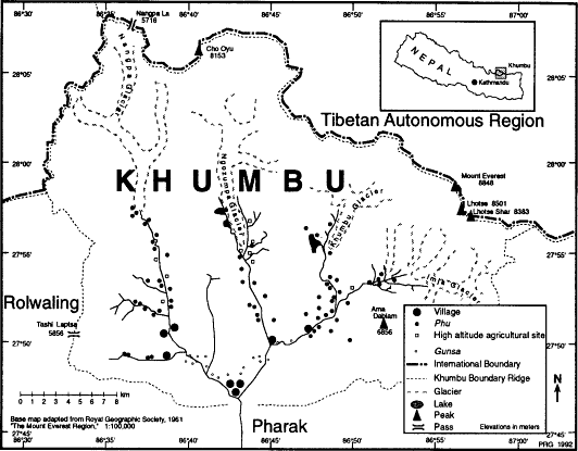
Multialtitudinal Settlement Khumbu Sherpas have developed a complex pattern of seasonal movement between houses in their main villages and other dwellings situated at different altitudes and as far as twenty kilometers away. Some families maintain as many as half-a-dozen houses and herding huts scattered throughout one or more valleys, living in each for a period ranging from a week to many months per year depending on their pattern of herding and the ways in which they integrate these with crop-tending requirements, social responsibilities in various places, and personal preferences. The complexity of scheduling agricultural and pastoral activities at a number of different sites often leads families to divide forces temporarily between several bases. The locations of the major villages and the scores of lower- and higher-altitude secondary settlements are shown in map 5 by settlement type, and the individual settlements of the Bhote Kosi, Dudh Kosi, and Imja Khola valleys are shown in maps 6 and 11.[55]
Villages (Yul) Level field sites in the steep terrain below 4,000 meters are rare and prized, and the eight main villages of the area hug the most prominent bits of a relatively gentle terrain between 3,400 and 4,000
Map 5.
Khumbu Settlement Pattern
meters. Half of the total Khumbu population inhabits three villages, Nauje (3,400m), Khumjung (3,790m), and Kunde (3,820m) in southernmost Khumbu near the confluence of the Bhote Kosi and the Dudh Kosi rivers.[56] The middle reach of the Bhote Kosi valley in western Khumbu, an area known as Thamicho, is a second major area of settlement. The three main Thamicho villages, Thami Og (lower Thami), Thami Teng (upper Thami) and Yulajung, are all situated at about 3,800 meters. Thami Teng and Yulajung occupy alluvial terraces on opposite sides of the Bhote Kosi, whereas Thami Og is located on the north bank of the Thami Chu just above its confluence with the Bhote Kosi and immediately south of the prominent old lateral moraine which stands between it and Thami Teng.[57] Eastern Khumbu has two major villages, Phurtse (3,840m) in the Dudh Kosi valley just above the confluence of that river and the Imja Khola and Pangboche (4,000m) on the Imja Khola just six kilometers to the east. Besides these villages there are also several smaller settlements which serve as the main base for a majority of the families who own houses in them. These include Milingo near Pangboche on the Imja Khola, Zarok just above Nauje, and several small settlements in the vicinity of Thami Teng including Worsho, Chanekpa, and Ong. In most cases families living in these settlements join with nearby main villages for a variety of social, religious, and community land-management purposes.
Main village houses are substantial structures of unmortared stone with gabled roofs of slate, fir shakes weighted with stones, or corrugated iron. Until recently all construction materials were locally obtained, including the white clay used to give houses their distinctive color. The tree-felling restrictions which the national park implemented in the late 1970s, however, have since meant that nearly all timber has had to be imported from Pharak. Sheets of corrugated iron are brought by porter from the road end at Jiri, and glass is now often flown in to Lukla.
All but the poorest families live today in two-story houses. These are constructed along very standardized designs and floor layouts and are generally about five by twelve meters in size. The lower story provides a stable for livestock and a storage area for grain, fodder, and fuel wood. The upper story is usually a single, large, open living room with front (usually south-facing) windows above a long window bench and a hearth area. The windowless back wall is lined with shelves on which the household wealth of copper water-storage vessels, brass cooking pots, carpets, and other worldly goods is displayed. Wealthy families may devote a separate room on the left side of the upper floor to a family chapel, but more often a simple altar located on the left wall of the main room suffices. Often houses face in a similar direction, an orientation influenced not only by sunlight and slope but also by geomantic beliefs about
auspicious and inauspicious directions and the danger of having a house face places such as caves inhabited by demonesses.
The eight major villages differ greatly in size and economic orientation as well as in such features as the conduct of community religious ceremonies and local resource-management institutions. Nauje is the region's second largest village.[58] Long the home of many of the region's major traders and a place where Rais, Sherpas, and Tibetans bartered salt, wool, and grain, it is today Khumbu's administrative, commercial, and tourist center and has grown into a small town with ninety-four resident Sherpa familes and a third as many non-Sherpa households.[59] Here is the region's only bank as well as a post office, government-operated clinic, elementary school, the office of the Northern Boundary Commissioner, and the first dental clinic in northeastern Nepal. On Mendelphu hill, overlooking the tiers of tightly clustered houses of the village proper, is the complex of buildings that forms the headquarters of Sagarmatha National Park. Part of the village has developed into a tourist district that in spring 1991 had twenty-one shops and eighteen lodges. Village families also run two more Sherpa lodges adjacent to national park headquarters at Chorkem. At one edge of the settlement is the site where on Saturdays the region's only periodic market is held. Here Rais and other traders sell grain and goods brought from settlements and road ends as far away as ten days' journey on foot. At night the village glows with more than 400 electric lights installed in 1983 with UNESCO aid and powered by a microhydroelectric turbine on the stream which flows from the village spring.
All the other Khumbu villages retain the atmosphere of rural settlements and their only signs of tourism development are a few modest lodges and teashops.[60] Khumjung, a sprawling village just an hour's walk from Nauje, is by far the largest of these. Its name, which may mean Khum (or Khumbila?) valley, may refer to its site in a valley at the foot of the sacred peak Khumbila.[61] With 135 Sherpa households it has the largest Sherpa population of all the Khumbu main villages. Here is the region's main elementary school, established in 1961, and its only secondary school. Both were built and maintained through the work of Sir Edmund Hillary and the Himalayan Trust organization. Adjacent to Khumjung and slightly higher in altitude is Kunde, upper Khum. Kunde has only fifty Sherpa households but is renowned as the location of the hospital established by the Himalayan Trust in 1966.[62]
Pangboche, the major village of eastern Khumbu, has two distinct sections that between them have sixty-eight households. The older, upper village (Pangboche Te Lim) occupies an amphitheater some 150 meters above the Imja Khola and directly below the spectacular summit of Tawache. This is the main settlement, with 89 percent of the village
households, most of them clustered in tiers around the amphitheatre walls and the village temple. The more recently established Wa Lim occupies a large alluvial terrace just above the Imja Khola. The seventeen families here do not have land holdings in the upper village.[63] They are, however, fully integrated into a joint social and ritual life.
The village of Phurtse perches on a small shelf 400 meters above the confluence of the Dudh Kosi and the Imja Khola. The name is said to refer to Lama Sanga Dorje's miraculous feat of having flown to this spot, leaving several marks of his landing on a local boulder. Here are the dispersed houses of sixty-two families. The older section of the village occupies the center and lower parts of the slope, whereas the prominent, dense cluster of houses in the upper northeast corner is a development of the present century. The old, dense birch forest that covers a slope adjacent to the village on the north is one of several Khumbu sacred forests.
The Bhote Kosi valley villages of Thami Og, Thami Teng, and Yulajung are smaller than the other Khumbu villages. Yulajung indeed has only fourteen resident families, most of whom also have houses down valley at the gunsa (winterplace) settlement of Pare. Thami Teng, with twenty-two households in the village proper, is the largest of a set of closely situated communities on the west bank of the Bhote Kosi across from Yulajung. It is the home of a number of the few Sherpa families who are still trading on a small scale with Tibet and two of the largest Khumbu yak herds. Thami Og, childhood home of Tenzing Norgay, has twenty-seven households and on the slopes above it is one of Khumbu's two important monasteries. In the nineteenth century it was the home for at least three generations of the political leaders of the region. One Thami Teng Sherpa speculates that the names Thami Teng and Thami Og may refer to the flat character of the settlement sites and their relative locations. The first part he considers to derive from the Tibetan thang , a flat place, while the te and me suffixes refer to upper and lower sites. Yulajung may get its name from a linking of the Sherpa yul , "village," with jung , a flat valley.
Subsidiary Settlements (Gunsa, Phu) In much of the Himalaya and Tibet herders who pasture their stock in regions far from their home villages often live in tents or in shelters largely made of bamboo mats. A small number of peoples, including the Sherpas of Khumbu, Rolwaling, and Gunsa, however, build substantial, stone herding huts. These may be located at altitudes either above or below that of the main village, and often crops are also grown at these sites. In Khumbu these huts are usually tiny, low-walled, stone structures with shake or slate roofs. Al-
most all are only a single story high and are seldom much larger than three by four meters with a port-hole-sized window or two, a dirt floor, and a simple hearth formed of three stones set into a tripod. Cramped and smoky at the best of times, they grow more so after the hay is cut from adjacent walled fields and the huts become not so much dwellings as hay-stores. Khumbu herders also make use of caves and resa , low circles of stones roofed with bamboo mats or tarps.
High-altitude herding settlements are known as phu and are sometimes also referred to as chusa (livestock place) or yersa (summer place). The highest are located at an altitude of 5000 meters in the alpine regions of the uppermost valleys. Gunsa (also referred to as chusa) are located below the main villages.[64] Many gunsa and some phu are not only herding bases but also have substantial areas in cropland. Houses in both gunsa and phu may be owned by families who have no interest in herding. Some of the subsidiary settlements between 4,000 and 4,400 meters are major crop-production sites, including Dingboche (4,358m) in the Imja Khola valley, Tarnga (4,050m) in the Bhote Kosi valley, and Na, Charchung, Tsom Og, and Tsom Teng (4,280-4,400m) in the Dudh Kosi valley. Houses in these places and in some crop-producing gunsa may rival a family's main village house in size. For a few families such houses are actually main residences and they may have no house in a main village. I will henceforth refer to upper valley settlements where a great deal of cultivation takes place as "secondary high-altitude agricultural sites" to distinguish them from high-altitude phu settlements that are primarily herding bases and hay-cultivation areas.
There are more than 300 high-altitude herding huts in at least eighty-six distinct settlements (not including resa). Most have associated hay fields and some also have small areas in potatoes. Some high-altitude herding settlements consist of only a single hut or resa whereas others have as many as thirty. Most are inhabited by families from several different main villages. There are twenty-three gunsa settlements in Khumbu typically situated on fragments of terraceable land deep in the gorges. Many are located as much as 500 meters below the fields of the main village. Like the high herding sites gunsa are small settlements that are often bases for families from several different villages. The largest have fewer than thirty houses. Some of the secondary high-altitude agricultural sites, by contrast, are quite large. Tarnga has more than sixty houses that belong to families from all the Thamicho villages and a few Nauje families. Dingboche has sixty-five houses, most of them owned by Pangboche villagers but some of them the property of families from Khumjung, Kunde, and Nauje. Five families have their main houses there today.
Settlement History Khumbu Sherpas believe that their ancestors came to Nepal from Kham, a region on the eastern edge of Tibetan-inhabited territory 1,200 kilometers from Khumbu. Written clan records kept by Shorung Sherpas also claim Kham as the ancestral Sherpa homeland and in particular trace a migration from the Salmo Gang area (now in China's Sichuan province) near Derge in the upper Jinsha Jiang (Yangzi) region (Oppitz 1968; Teschke 1977). Sharwa , as Sherpas call themselves, means "easterners" or "people of the east" and may reflect this migration.[65] Oppitz suggests that the number of people involved was quite small, perhaps as few as twenty-five to fifty persons (Ortner 1989:26). Based on references in the texts to one of the emigrants being a student of Terton Ratna Lingba (1401-1477) Oppitz (1968:143) suggests that the original emigration from Kham "took place at the turn of the 15th to the 16th century.[66] The reasons for the departure of the small group of families from Kham can only be guessed at. Oppitz speculates that military incursions by Mongols from the Koko Nor (Qinghai Lake) region of present Qinghai province may have been a factor (ibid.:143-144) and there is mention in the texts also of dreams and visions that guided the leaders of the group (Ortner 1989:29). According to Konchok Chombi the emigrants' reluctance to take part in a coming war was also an important reason for their departure from Kham.
The migration took a period of years. Both Oppitz and Khumbu traditions agree, however, that it was accomplished by the same band of people who set out from Kham. The emigrants did not take leave of Kham with an intention to cross the Himalaya, for they clearly hoped to settle in central Tibet. They were unsuccessful, however, in their efforts to find a new homeland in south-central Tibet. According to some accounts they attempted to settle first in the Lhasa area and then in the Tinkye area, where Oppitz suggests they settled for a few decades south of Tsomo Tretung lake. He relates the subsequent abandonment of the Tinkye area to a reference in the Ruyi to invaders called Dohor Durkhi, whom he believes may have been the Muslim armies of Sultan Sa'id Khan of Kashgar which, under the command of Mirza Muhammad Haider, campaigned against the Buddhist "idolators" and in 1531-1533 nearly reached Lhasa (ibid.:144). Oppitz speculates that the immigrants moved rapidly from Tinkye to the Tingri region just to the north of Khumbu and then crossed the Nangpa La into Khumbu around 1533 (ibid.:144). According to Khumbu legends the ancestors of the Sherpas may have also tried to settle in the Tingri area near Langkor, but found that they were unwelcome after their yaks grazed in the barley fields of local farmers.
There are two oral traditions about the Sherpa discovery of Khumbu.
According to one the way over the Nangpa La was first found by a hunter, Kira Gombu Dorje, when he was pursuing a quarry which in some versions was a musk deer and in others a blue sheep. Some people believe that the deer was actually the embodiment of Khumbu Yul Lha. In the second a scouting party of three friends (Lama Serwa Tungel, Mijen Thakpa, and Thimi Sangbu Tashi) reconnoitered the pass and the Bhote Kosi valley beyond it. According to Konchok Chombi's reckoning of his own genealogy, eighteen generations have been born in Nepal since the ancestors of the Sherpas crossed the Nangpa La into Khumbu.[67]
The immigrants who passed across the Nangpa La into Khumbu did not all settle there permanently. Most apparently continued south after a few years, following the Dudh Kosi valley into the lower-altitude forested regions of Pharak, Shorung and Golila-Gepchua. In Khumbu it is believed that a few immigrants remained in Khumbu and adjacent Pharak and that these families constituted the nucleus of what later became the Sherpas of Khumbu. This early Khumbu population was apparently very small and remained so into the nineteenth century despite population growth from natural increase and further in-migration.[68]
The families which originally crossed into Nepal are believed to have belonged to several different clans, the ancestors of the Khumbu clans of today.[69] Oppitz (ibid.:144) refers to these as the four protoclans (Serwa, Minyagpa, Thimmi, and Chakpa) and suggests that they may originally have had separate territories, although on this point Khumbu traditions offer no confirmation. In Shorung and the area just west of the Lamjura pass early settlements were apparently established on a clan-exclusive basis. How and when the multiclan villages characteristic of Khumbu developed is not known. Oppitz believes that the Thimmi protoclan originally settled the Bhote Kosi valley (primarily the lower valley between the later settlement at Thami Og and Nauje) between 1533 and 1550 while Minyagpa families settled Phurtse and Pangboche (Fürer-Haimendorf 1984:27-28). Over the course of a few generations a number of new clans were established. Some, according to oral traditions and genealogies, were the result of the fissioning of clans into sets of exogamous brother clans following a ban on marriage between the offspring of brothers. In other cases the new clans reflected a decision by new immigrants from Tibet to take clan names based on their areas of origin.
The first settlers from Kham must have found Khumbu a rather different place than it is today. According to legend Khumbu was then in its lower reaches far more densely forested than now and richer in wildlife. Some stories describe Khumbu as a wild area and also as a "god's place" which had been set aside from the ordinary world until it was revealed to the faithful as a refuge for believers.[70] The idea that divine guardianship kept Khumbu hidden until the arrival of the Sherpas also figures in a
legend of an early king who wished to settle in Khumbu but was deceived by the gods into believing that the area was uninhabitable. When he went up into the valleys of Khumbu the gods made him see only huge lakes that threatened to flood the lower country. He had established a palace on the great rock at Monjo, just south of Khumbu, but after this decided to abandon the region altogether. He is said to have eventually established his capital at Dolakha, a place more than a week's walk to the west, where he is now supposedly honored as a god.
There are a number of Khumbu oral traditions which recall that at the time of Sherpa settlement the region was already being used as summer pasture by Rai shepherds. Old stories refer to these summer visits, and certain ruins in high places in the Dudh Kosi valley are sometimes said to be remains of Rai shepherds' huts.[71] Another legend offers an explanation for the lack of permanent Rai settlement. This tale details the attempts of the Kulunge Rai culture hero Ma Pe to settle in Khumbu long ago. According to the story Ma Pe crossed into Khumbu by the now difficult Amphu Laptsa pass in eastern Khumbu and settled in the upper Imja Khola valley. He built a house and tried to cultivate fields at Dingboche. There he found his crops ill-suited to the altitude and he moved lower in Khumbu. There again the crops were poor and his subsequent attempts to farm other Khumbu sites were also discouraging. Eventually he gave up and moved farther down the Dudh Kosi valley where he found a suitable site at Bupsa near Kharikhola in Katanga. This has been, it is said, the highest and northernmost place of Rai rice cultivation ever since.[72] Other possible indications of early Rai settlement are remembered in the legend that Rais may be reincarnated in one place in Khumbu in the upper Imja Khola valley near the Tengboche monastery. There are also a number of place-names in Khumbu and Pharak which are said to date from Dongbu times (these may also refer, however, to nineteenth-century herding by Gurungs, who, like Rais, are called Dongbus by Sherpas). These names, such as Dusa and Ralha, refer to sheep- and goat-herding activities. There may even be an old recognition of Rai association with Khumbu in the name Khumbu itelf. The Dudh Kosi valley is known to Rais as a part of Majh Kirat called Khambuan, "land of the Khambu." And Rais in this part of Nepal have long referred to themselves as Khambu, tracing their lineage back to an ancestor named Khambuho (McDougal 1979:3). Perhaps Sherpas adapted a slightly modified pronunciation of this local regional name.
Rais would have found Khumbu an uncongenial place for the rice and millet that were presumably their main crops in that era before maize was a common crop in Nepal. But the possibility of Rai summer transhumance into Khumbu is plausible given current Rai sheep-herding
patterns in nearby areas. Summer pastoralists may also have augmented their food supplies by planting buckwheat, barley, or tubers. The ancestors of the Rais or even earlier predecessors in the Dudh Kosi valley might very well have used swidden cultivation in the then presumably well-forested lower Khumbu valleys or set fire to woodlands in order to improve grazing. Such practices might account for the very early habitation suggested by Byers on the basis of pollen studies which revealed cerealia grains which may date back 1,500 years (Byers 1987b :199, 204).[73]
Khumbu oral traditions recall early conflict between the immigrants from Tibet and the indigenous Rais in both Khumbu and Shorung. According to one legend the first settlers had already planted some crops when they were accosted by Rais who told them they could not grow crops or settle there because the land belonged to the Rais. The Sherpas then asked permission, pointing out that they had no food and could not return to Kham. The Rais relented.[74] Another story set a few generations later describes an armed conflict between Rais and Sherpas in southern Khumbu. Sherpas are said to thereafter have had to pay an annual tax to the victorious Rais, presumably until Prithivi Narayan Shah consolidated his control over the Dudh Kosi region in the late eighteenth century and made it part of the new Shah kingdom of Nepal.[75] Ortner (1989:84) suggests a date of 1717 for the Sherpa defeat. There is also a tradition that an early division of territory between Sherpas and Rais took place in the region of present southern Solu-Khumbu and Olkadunga districts.[76] Documents from the reign of King Rajendravikram Shah (1816-1847) note that parts of Solu-Khumbu and its pasture regions were formerly under Rai control (Pradhan 1991:62).
Early Settlement A rich body of oral traditions concerning early events in Khumbu depicts the Bhote Kosi valley as the center of population and political administration.[77] The rest of Khumbu in the early years of Sherpa habitation appears to have been a very sparsely settled, primarily wild country in which a few lamas had established religious retreats and temples.
Several legends are set within the Bhote Kosi valley during the first few generations of Sherpa habitation. A number concern Dzongnangpa, an autocratic administrator who persecuted Sherpa lamas and was ultimately assassinated. According to some accounts Dzongnangpa was originally a Tibetan official in Shekar (east of Tingri). After being disgraced there he crossed the Himalaya to Khumbu where he eventually obtained considerable power, began to rule in a style that was extremely high-handed, arbitrary, and offensive by Sherpa standards, and became
one of the classic villains of Sherpa oral traditions. The degree of his misrule is most vividly illustrated in his oppression of local religious figures. He is said to have been responsible for the death of one Sherpa lama at Zamde (near Mingbo in a tributary valley north of Thami Teng) and to have persecuted a second, Lama Sanga Dorje.[78]
The Tarnga area especially figures in the legends as an early settlement site. Tarnga today is a secondary high-altitude (4,050m) agricultural site famous for growing the best-tasting potatoes in Khumbu. In the early accounts it figures as the seat of Dzongnangpa's power. Some elderly Bhote Kosi valley villagers remember a large rubble pile said to have been the remains of Dzongnangpa's palace. It was also at Tarnga that yeti are said to have caused so much damage to Sherpa crops that the Sherpas staged a devious trap which very nearly caused the extinction of yeti in the region.
Tarnga would have been an appealing early settlement site. It is situated only slightly higher in altitude than today's main villages, has one of Khumbu's largest expanses of relatively level, arable land, and is one of the two places in the region in which irrigated barley can be grown on a large scale. One shortcoming is the absence of any adjacent woodland, but in earlier times Tarnga may have had better access to timber and fuel wood than at present. The highest patches of forest remaining today are located near Mingbo and Chosero, just south of Tarnga, and there may once have been shrub juniper cover or even open woodland nearer to Tarnga itself. If Tarnga was the early focus of settlement in the Bhote Kosi it is unclear why and when the center of settlement shifted to the present main villages of the valley. This certainly took place well over 150 years ago, for through much of the nineteenth century Thami Og was the political center of Khumbu.[79]
Some clues to the settlement of eastern Khumbu can be gleaned from the extensive set of traditions concerning Lama Sanga Dorje, the great spiritual hero of Khumbu history. Besides recounting Lama Sanga Dorje's magical feats these legends tell of his travels through Khumbu in search of auspicious places to mediate and to found temples, and his persecution by Dzongnangpa who was jealous of his powers and popularity among Sherpas.[80] Although this is not the place to discuss the details of the many stories of Lama Sanga Dorje's birth, life, and death, his role in the establishment of Pangboche is pertinent. After deciding to leave his earlier hermitages in the Bhote Kosi valley because of the escalating tension with Dzongnangpa, Lama Sanga Dorje is said to have explored eastern Khumbu for a site to establish a temple. He decided against building a temple at what later became Phurtse and also rejected the ridge where the Tengboche monastery was later built. Ultimately he built a small temple at Pangboche. There may have been earlier temples
in Khumbu, although what are called temples in the stories of the earliest Khumbu years may have been only the hermitages of lamas. Pangboche is clearly described as a temple and, more than that, as having originally been the place of worship for a community of celibate monks. Ortner speculates that it could have been founded between 1667 and 1672 (1989:49).[81] The site of the new community of Lama Sanga Dorje's spiritual followers was apparently intended to be in a remote place where they would not be harassed as they had been in the Bhote Kosi valley. According to one story there was both a community of monks and a nearby community of nuns.[82] After Lama Sanga Dorje left the area for Tibet, where he eventually died, these followers stayed on. Intermarriages between nuns and monks subsequently took place and a settlement grew up. The compact clustering of houses in the upper village, one villager noted, reflects its origin in the tightly grouped monks' houses that usually surround monastic temples.
It is unclear when Khumjung and Kunde were founded, but it seems likely that this took place after the immigrants had established a foothold in the Bhote Kosi valley and may have also come after the development of Pangboche. The establishment of the village of Kunde a short distance up valley from Khumjung may not have taken place at the same time as Khumjung's settlement and is assumed by some Sherpas to have come later, or at least to have developed more slowly. I know of no oral traditions concerning the establishment of the two villages, nor are they mentioned in the oral traditions of the early generations of Khumbu settlement. Khumjung was certainly settled long ago, for some families there trace eleven generations born there and believe that they were not the original settlers. Two early temples or religious retreats that do figure in the oral traditions, Gormuche and Lhonang, are said to have been located not far from Khumjung, but this casts no light on whether Khumjung had already been founded.[83] One of these hermitages belonged to Lama Sanga Dorje's father. There is an oral tradition that the valley where Khumjung later grew was a lake or marsh during the early period of Sherpa settlement. The first houses in the area are said to have been built on the slopes below Khumbila rather than on the flat valley floor.[84] Khumjung and Kunde, whenever they were established, might long have been relatively small settlements. This is suggested by the tradition that while temples were established in the sixteenth or seventeenth century in Thami Og and Pangboche there was no village temple in either Khumjung or Kunde until the 1830 establishment of Khumjung temple. Before this villagers journeyed either to Thami Teng or Pangboche for important events such as the Dumje rites (Khumjung villagers in this era went to Thami Teng whereas Kunde villagers, like Phurtse families, went to Pangboche).[85] Another suggestion of the rather late
settlement of the Khumjung-Kunde region is that Khumbu traditions relate that Khumjung and Kunde were first settled by people from the Paldorje, Chusherwa, and Jongdomba (Dzongnangpa?) clans (Fürer-Haimendorf 1984:28). The latter two clans are members of the seven "new clans" that Oppitz (1968:145) believes represent immigration from Tibet long after the early Sherpa settlement.
Phurtse was presumably founded after the establishment of Pangboche. The first families are reported to have belonged to the Shar Dorsum, Shar Tazum, and Shar Sundokpa clans (subclans of the Sherwa). The settlement took place long enough ago for subsequent changes in the definition of these "brother clans" and for abandoning the original strict bans against intermarriage between Shar Dorsum and Shar Sundokpa after the area was also settled by Shar Penakpa, Paldorji, and Sundokpa clan families. The original settlement must have been sometime before the early nineteenth century, for nine generations ago Phurtse families were among the early settlers of Nauje.
Nauje is considered to be the youngest of the Khumbu villages, dating only to the early nineteenth century. The settlement is mentioned (as Namche Bazar) in an 1810 A. D. Kathmandu document entitled "Order to Inhabitants of Solu Regarding Trading Rights Beyond Namche" discussing trade regulations (Regmi Research Collection , vol. 49:209, in Schrader 1988:245), and in an 1828 trade document seen in Khumbu by Fürer-Haimendorf (1975:61). Before the establishment of a village at the present site Sherpas from Khumjung had herding huts and fields in the area.[86] Permanent settlement in Nauje is thought to have begun when five Khumjung families made the place their main base. They are said to have been attracted to the site because of the spring, one of the finest in Khumbu. Other immigrants from Khumjung and also from Phurtse soon followed. The first houses were built on the south facing slope and one of them became the stopover for Tibetan tax collectors who came to Khumbu until the Nepali victory in the 1855-56 war between Nepal and Tibet.[87]
Khumbu became part of Nepal in 1772-1773 when the Dudh Kosi region was incorporated into the Kathmandu government of the Shah kings (Limberg 1982:149). Sherpas began to pay a small land and house tax to Kathmandu, the revenue being collected in Khumbu by eight Sherpa pembu who were overseen by a Sherpa gembu, the highest local official. This office was held by Thamicho men during the nineteenth century and by the powerful Tsepal, a resident of Nauje, in the early twentieth century.[88] The eight hereditary Khumbu pembu, also men of great power, prestige, and wealth, were mainly responsible to the Kathmandu government for collecting taxes, but also filled a much larger role in Khumbu society as patrons and arbiters.[89] They may once
have functioned as village headmen, but even in the early nineteenth century had ceased to do so and instead collected tax from clients who often lived in several different villages. This may have reflected migration of families from long-established settlements to new areas, with the families in such cases continuing to pay tax to the same pembu even though they now cultivated different areas. Whereas some villages had no resident pembu, others had several.
During the late nineteenth and early twentieth centuries Nepali administration of Khumbu was conducted by visiting officials and by the gembu and pembu on the behalf of Kathmandu. Only in the 1940s did the central government open up an office in Nauje, before that con-tenting itself with occasional visits by its officials. The region was remote from the capital and in many ways largely governed its own affairs. Yet the state did play an important role in some dimensions of Khumbu life. Government edicts about subjects as diverse as trade regulations, yak eating, and marriage regulations greatly affected Khumbu lifestyles. An 1828 royal edict that gave Khumbu Sherpas a monopoly on trade north over the Nangpa La was crucial to Khumbu Sherpa development of their distinctive subsistence strategies and historical regional economy.[90] Land taxes may never have greatly influenced the orientation of Khumbu crop production, but they may have been a hardship on poorer families in the late nineteenth and early twentieth centuries and a factor in migration out of the region. Decisions handed down by the Nepali court system could have great impact on questions such as village land boundaries and rights to resources. Khumbu Sherpas have long seen the courts as a way to settle major land disputes and civil suits that could not be resolved to everyone's agreement within Khumbu as well as a way to defend local traditions and rights against the government itself.[91] Courts were also used to defend Khumbu rights and privileges against encroachment by non-Khumbu citizens. In 1947, for example, 248 Khumbu Sherpa men successfully brought a case against three Pharak Sherpas whom they accused of trading with Tibet over the Nangpa La.
In the past forty years Khumbu has undergone enormous political, economic, and social changes. Khumbu began to be much more closely integrated politically with the rest of Nepal following the 1950-1951 revolution that restored the Shah line to greater power after more than a century of rule by the Ranas, a family who had seized effective power in 1846 and ruled as hereditary prime ministers. Local administration was reorganized after 1960 with the introduction of a new, national partyless system of local government, the panchayat system. Until 1968 all Khumbu constituted one government unit, along with all of Pharak as far south as Surke. Thereafter it was divided into two village panchayats, one comprised of Nauje and Thamicho and the other of Khumjung,
Kunde, Phurtse, and Pangboche. Each elected a pradhan pancha , an assistant (uppa pradhan pancha ) and a set of lesser officials (adekshe ) representing the nine wards in each village panchayat.[92] The pradhan pancha were to replace the pembu, who lost their tax-collecting privileges and their command of annual corvée labor (wulok ) from their clients. Henceforth the panchayat was to be responsible for tax collection, although in practice most Khumbu pembu continued to collect the tax from their clients and then turned it over to panchayat officials.[93] The central government established a branch district office in Nauje in 1965, charged with regulating the Tibet trade and carrying out other duties that for some years included administering a new national system of regulated forest use. Officials of this office also oversaw the extension of the national land-registration system (bhumi sudar ) to Khumbu in 1965-1966. Other government facilities were gradually added. Most were established in Nauje, which became the administrative center for Khumbu. Perhaps the most significant institutional introduction was the establishment of Sagarmatha National Park in 1976. The Khumbu economy also underwent an important change with the decline of trade with Tibet in the 1960s, the establishment in 1965 of a Saturday market at Nauje, and the rise of the tourist industry.[94] In 1979 Nauje's increasing growth as a commercial and tourist center was marked by the opening of the region's first bank. Other important developments were the building of the Hillary schools, beginning with the Khumjung school in 1961, the construction of the Lukla airstrip in 1964, the establishment of Kunde hospital in 1966, the arrival of electricity in the region in 1983 with the completion of the Nauje hydroelectric project, and the abandonment of the panchayat system throughout Nepal in spring 1990 and its replacement in Khumbu by two village development committees corresponding to the former village panchayats.