8—
The High Cliffed Area between Sorrento Valley and North La Jolla
Description of the Area
The spectacular cliffs along this section of the coast reach a maximum height of over 350 feet and extend from Sorrento Valley (Penasquitos Lagoon) to La Jolla Shores. These cliffs consist of ancient lagoonal marine and terrestrial sediments of Eocene age, with a capping of iron oxide—cemented terrace deposits of Pleistocene age (fig. 63). At the south end, a volcanic dike of Miocene age cuts the sediments, and south of the dike there is an infilled embayment of late Pleistocene sediment, including iron oxide—cemented alluvial sands and gravels.
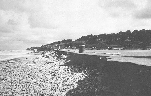
Figure 64
April 1983 view looking north along the undermined, collapsed portion of Highway 101, at the mouth of the Sorrento
Valley.
Photo : G. Kuhn.
History of the Lower Reaches of Sorrento Valley
Among the earliest inhabitants of the area were the San Diegueño Indians. Numerous shell midden deposits have been found along the high slope surrounding the valley. Shells have been dated by amino acid method to about 4,500 to 10,000 years old (Masters and Bada 1978).
The northwesterly trend of the valley is thought to be structurally controlled as it parallels the La Nacion Fault to the south, and as it is oriented in an anomalous direction toward the lagoons to the north. In 1874, Judge Benjamin Hayes described the extensive cobble barrier that completely sealed off the mouth of the lagoon and noted that its height exceeded forty feet above sea level. In 1889, the California Southern Railroad installed a beach shingle railroad siding in order to mine cobbles for use as abrasives and as paving material for the streets in the city of San Diego. The highway at this location was severely damaged between January and April of 1983 as storm waves launched beach cobbles and riprap against and onto the road (fig. 64).
In 1883 the railroad company located its right-of-way through the valley. During the great storms and flood of 1884, the railroad had to be dug out after massive landslides sealed off the lower valley and buried the track (San Diego Union , 2 March 1884). Since then, Sorrento Valley has been flooded on several occasions, the last time in 1938. At that time, only ranches and farms existed there, and the structures were high up the slopes, safe from the floodwaters. In the late 1960s, however, extensive development took place in the eastern section of the valley, and it is now a huge industrial park. Future floods could be rather serious, since there is no adequate flood control channel to handle a large volume of water.
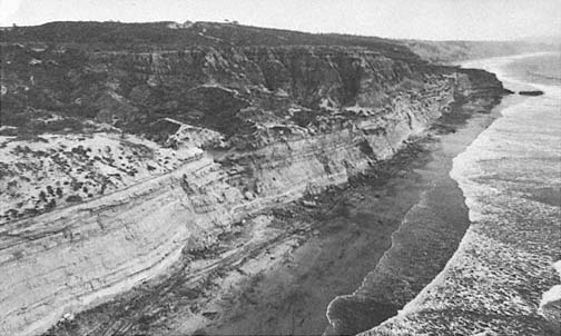
Figure 65
Oblique aerial view of the cliffs looking south at Torrey Pines State Park, south of Del Mar.
Bathtub Rock is visible at the far right.
Photo : California Coastal Commission.
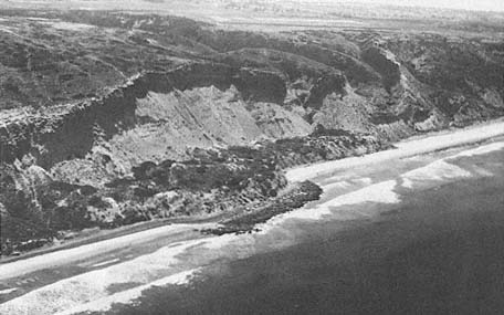
Figure 66
View of Torrey Pines landslide which measures approximately 1,700 feet along the
cliff, 1949.
Photo : F. Shepard.
Torrey Pines State Preserve and Its Cliffs
Thanks to the generosity of Miss Ellen Scripps, Torrey Pines was purchased as a state preserve in the 1920s. These magnificent cliffs and canyons thus have been preserved in their natural state and may be enjoyed by the general public. Cliff retreat along this area occurs in small rockfalls, as far north as Bathtub Rock (fig. 65). Bathtub Rock itself was hollowed out by a Welsh coal miner who thought it looked promising for a coal seam, but nothing of the sort was found. Just north of Bathtub Rock, a path leads up to the Torrey Pines State Park Center. To the left of the trail, as it leaves the cliffs, is a small sand deposit with many beach-type shells at an elevation of sixty-five to seventy feet above the present sea level. These sediments show the typical beach laminae. The shells have been dated at approximately 120,000 years B.P ., both by uranium thorium and amino acid dating methods (Masters and Bada 1978). This is an uplifted remnant of the beach from a period of relatively high sea level during the latest interglacial stage.
Torrey Pines Landslides
South of Torrey Pines the cliffs are disturbed by extensive landslides. The largest of these measures approximately 1,700 feet along the cliff and several hundred feet landward and is called the Torrey Pines Park landslide (fig. 66). When the U. S. Coast Survey mapped the area in 1889, this landslide and others to the south appeared to be quite recent, as talus and debris extended far out on the beach. The Torrey Pines Golf Course is located along the top of the bluff just south of this point, and in 1982 new fractures were noted directly inland from the old landslide.
Blacks Beach Landslides
Blacks Beach (now Torrey Pines City Beach) has vertical and near-vertical cliffs over 350 feet high. During the summer, as many as 50,000 people may be on the beach at one time. For many years Blacks Beach was the only legal nude beach in southern California, and even today the practice is not entirely eliminated. It is fortunate, considering the large numbers of sunbathers, that few landslides have occurred in recent years. In the past, Blacks Beach has apparently experienced very large landslides, as noted by Sumner and Ross (1930). They described a failure between 1917 and 1922 with dimensions of 450 feet along the shore, 175 feet to the base of the cliff (75 or 100 feet wide higher up), and approximately 200 feet of the vertical cliff face. Prior to 1940, a large talus buildup allowed access to a hanging valley. During the storms at the end of 1940, this talus was completely removed (Kuhn and Shepard 1979a ) and was not reconstituted until about 1970.
In February 1982, a massive landslide occurred at this same location, measuring approximately 750 feet along the cliff by 280 feet into the cliff (fig. 67). This slide carried material, including large boulders, across the beach to the water, cutting off one side of the beach from the other except at low tide. The fallen material comprised acres of sandstone and provided a large future source of sand for the beach. Prior to this movement, groundwater was seen on the cliff face, and tensional fractures were noted along the top by San Diego city lifeguards. A local engineering geology firm, Leighton and Associates (1981), had completed a reconnaissance study of the area in May 1981 and had mapped an existing old landslide at the site. At the time of their report, fractures existed farther back from the landslide head scarp, indicating sections of future failures.
The 1982 landslide occurred during a very benign winter with little rainfall and few storms. Interestingly, on the evening prior to the cliff collapse, the seismograph at Scripps Institution of Oceanography registered a surface wave, with no earthquake being reported. It therefore appears that collapse of this
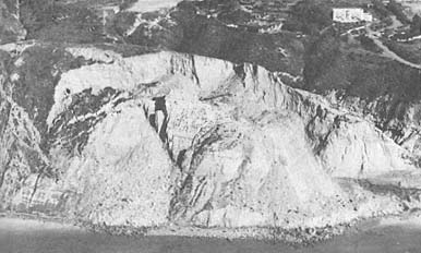
Figure 67
Landslide at Blacks Beach north of Scripps Institution of Oceanography
(SIO) which occurred January 29, 1982. Note the recent slide material on
the beach and the fresh vertical scarp behind the slide.
Photo : Ron McConnaughey.
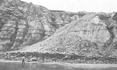
Figure 68
February 1978 view of the fall of 1977 landslide debris along the cliffs in front
of the former Drell residence.
Photo : G. Kuhn.
slide was forthcoming, as the earth shock indicated that a major section had broken loose. In 1977, before the heavy rains of 1978, a landslide occurred directly in front of the former Drell residence in the La Jolla Farms area (fig. 68) (SCT Consultants 1979). This slide included approximately forty-five feet of the yard on the seaward side of the house, and debris from the slide reached far across the beach below.
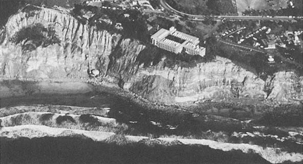
Figure 69a
March 1978 oblique aerial view of the National Marine Fisheries Building. Note the funicular tram built at a
precarious position north of the building, and the rockfall directly in front of it. An old landslide was
discovered to be under the building after it was constructed.
Photo : G. Kuhn.
Spectacular Location of the U. S. Fisheries and Wildlife Buildings, and the Cliff Margin of Scripps IGPP Building
When Andy Anderson purchased the property along the sea cliffs just north of the Scripps Institution grounds, he developed the property to have spectacular views from his home of the cliffs to the north and beautiful Point La Jolla to the south. He never gave a thought to the possibility that a large building might be constructed next to his property and thus completely block his view to the south, but that is exactly what happened. The National Marine Fisheries Building was constructed in the 1960s just above the cliffs, north of Scripps Institution (fig. 69a ). The structures were exempted from local building code requirements for a preconstruction engineering geology study because it was a U. S. Government complex (Moore 1973). In 1963, geologists from Scripps Institution noted
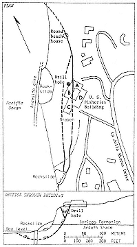
Figure 69b
Sketch of the same site as that in
69a , showing the mapped and
the inferred structural relations
at the National Marine Fisheries
Building landslide, 1973. From
Moore 1973.
the possibility that the buildings were on a landslide (Frautschy 1963). A thorough study, conducted after the architects received a letter from the concerned geologists, ascertained that the Fisheries buildings did indeed stand on a block-glide landslide (Moore 1963). Periodic micrometer measurements were made between each of the four buildings of the complex, from September 1967 to April 1973. It was noted that during that period Building B moved down, relative to Building D, at a rate of 2.2 millimeters per year (Moore 1973) (fig. 69b ). However, it was noted by Moore (1968) that much of the measured movement was related to rather distant earthquakes. Previous investigators of the area (Hanna 1926:233; Vaughan 1932) noted the gross instability of these cliffs during wet years and the concomitant hazard of situating not only buildings but even access roads along the fragile margins.
There did not appear to be a good site for another building to the south of the Fisheries Building, since there was a ridge along the seaward side and a longitudinal valley on the landward side. However, on the suggestion of Dr. Walter Munk, who wanted a building in this location, and with the help of his architect wife, the University filled in the valley and constructed the building for the Institute of Geophysics and Planetary Physics (IGPP). In recent years, the west end of the building has developed a lean toward the ocean.
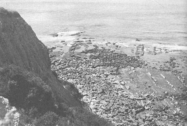
Figure 70
View of the low cliffs bordered by the wave-cut terrace at La Jolla, 1948.
Photo : F. Shepard.