The Land
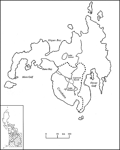
The wide green land evoked in the first line of a popular song of the Muslim separatist rebellion is a metaphorical reference to the territory known as Cotabato and a description of the Cotabato River Basin, the broadest expanse of lowland on the island of Mindanao and the most densely settled. Mindanao is the second largest island in the Philippines, and "Cotabato" (see map 1) is the term used to refer to the entire southwestern quadrant of Mindanao, which is divided into roughly half lowland and half upland areas. That region formed the domain of the two principal sultanates of Mindanao. With colonialism it was incorporated as a single political subunit—the District of Cotabato—under the Spanish and Americans, and the Province of Cotabato under the Philippine republic. It is presently divided into four separate provinces but still considered collectively as Cotabato. The hydraulic, demographic, and political hub of Cotabato has always been the Cotabato River Basin.
The Cotabato Basin is drained by the Pulangi River, referred to respectfully by the Spaniards as the Rio Grande de Mindanao. The Pulangi has its source in the Central Mindanao Highlands near the northern coast of the island and flows southward across the Bukidnon Plateau. It then emerges onto the Cotabato plains, depositing fertile mountain silt as it widens and arcs westward through the 1,000-square-mile Cotabato River Basin, and finally empties into Ilana Bay.
Map 1.
Cotabato and the Pulangi River system
Where the river makes its wide turn to the west, two large marshlands—the Libungan and Liguasan Marshes—have been created. Together they cover an area of 450 square miles during normal water levels, with each marsh expanding dramatically when the river overflows its banks during seasonal rains. This periodic inundation of much of the valley floor is the source of the name for the principal ethnolinguistic group of the Cotabato Basin—the Magindanaon. The word "danao" refers to inundation by water, and "magindanao" is likely a shortened form of "mag inged sa danao" or "those residing at a flooded place" (Llamzon 1978, 131). The Magindanaon, or "people of the flood plain" (Stewart 1977) lent their name, in its shortened form, to the entire 36,000-square-mile island, called Mindanao by the Spaniards in apparent acknowledgment of the extensive territorial influence of the Magindanao Sultanate, the foremost principality of the island.
The term "Cotabato" is a hispanicized version of the Magindanaon "Kuta Watu," or fort of stone. That Spanish appellation for the city and region (formerly identified on maps as Magindanao or Mindanao) was said by Najeeb Saleeby, writing early in the twentieth century, to be "very modern" (Saleeby 1905, 13). The name "Cotabato" was taken from an actual stone fort that stood on Tantawan Hill in the middle of present-day Cotabato City (Mastura 1979; Millan 1952). About twenty miles before reaching the sea the Pulangi splits into two branches. The narrower southern fork is known as the Tamontaka River. The wider north fork of the Pulangi flows past Cotabato City, which is located on its southern bank about four miles above the river mouth. The Pulangi also collects water from several large tributaries along its lower course.
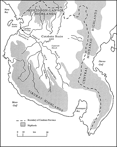
The Cotabato Basin (see map 2) is bounded on the southwest by the Tiruray Highlands. These uplands extend for more than 125 miles along the Moro Gulf and Celebes Sea and descend sharply to the west, dividing a slender coastal plain from the long and narrow Alah Valley. To the north lie the Bukidnon-Lanao Highlands, which encompass nearly all the northern portion of the island. The Lanao Plateau and Lake Lanao Basin lie at the southwestern corner of these highlands, closest to the Cotabato Valley. The densely populated basin of Lake Lanao is the single exception to the general pattern of sparse settlement in the highlands. To the east lie the Central Mindanao Highlands, a succession of mountain ranges that separate the Cotabato Basin from the lowlands facing the Davao Gulf.
Map 2.
Physiography of southwestern Mindanao