Road Logs A, B, CClemens A. Nelson
with botanical additions
by Mary DeDecker and James MorefieldIn the following road logs, figures in the left column are distances between points of interest with comments; figures in the next column (in parentheses) represent cumulative mileage. Frequent reference is made to clock directions to various features, such as prominent peaks (e.g., Mt. Tom is at 11:00). The clock is oriented with noon straight ahead. For each road log, reference is made to appropriate U.S. Geological Survey 15-min-topographic quadrangle maps showing road networks. Road Log AOwens Valley Laboratory (OVL) to Barcroft Station of White Mountain Research Station (WMRS) and return (Bishop, Big Pine, Waucoba Mountain, Blanco Mountain, and Mt. Barcroft 15-min quandrangles). | | 0.0 | (0.0) | Depart OVL, note odometer at gate, turn left, and proceed on East Line Street to Bishop. The high pyramidal peak ahead is Mt. Tom (13,652 ft). Its crest exposes brown metasedimentary rocks of Paleozoic age, which extend north to Pine Creek Canyon; here these rocks contain the ores of the Pine Creek Tungsten Mine. Farther north, the prominent steep-faced ridge is the Wheeler Crest. South of Mt. Tom, the flat-topped feature is Basin Mountain. The Sierran front from Bishop northward is marked by a major fault escarpment along which the Sierra Nevada has been uplifted in relation to the Owens Valley. | 3.6 | (3.6) | Intersection of East Line Street and U.S. Highway 395. Turn left. At the south end of Bishop, the eastern front of the Sierra has changed significantly. This portion, called the Coyote Warp, is that part of the Sierran front extending from Bishop Canyon some 15 mi south to Big Pine Canyon, which has experienced bending or warping. This is in sharp contrast to the steep fault scarp faces of the eastern Sierran front both south and north of the Coyote Warp. This interpretation is supported by well data in the Owens Valley that indicate that, at this latitude, the alluvial fill of the valley varies from nearly zero on the west to several thousand feet beneath the east edge of the valley. | 5.5 | (9.1) | Collins Road. Marble Canyon is at 9:00 in the White Mountains. The Precambrian-Cambrian section exposed on both sides of the canyon |
|
― 56 ― Figure 3.9
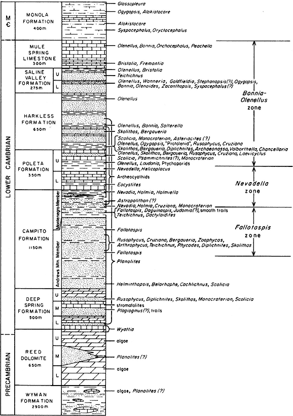
White-Inyo Precambrian to Middle Cambrian stratigraphic section, showing distribution of trilobite faunas,
archeocyathans, trace fossils, and Wyattia . Abrreviations: M — Middle Cambrian.
― 57 ― | | | | | is obscure in the morning light; it can be seen in better detail on the return leg. | 1.7 | (10.8) | Keough's Hot Spring Road. The hot springs, at 3:00, are located along a bounding fault at the front of the Sierra. Even in the area of the Coyote Warp, frontal faulting is of local significance. | 5.5 | (16.3) | Reynolds Road on right. Crater Mountain, a Pleistocene volcano, is at 1:30; the rugged profile of the Sierran Palisades Crest, south of the Coyote Warp, is visible from 2:00 to 3:00. Beyond Reynolds Road, from 10:00 to 11:00, are the Waucobi embayment (the large recess in the front of the White-Inyo Range), the Pleistocene Waucobi Lake beds (white), and the Caltech radio telescopes on the floor of the valley. | 1.3 | (17.6) | Turn left onto Westgard Pass-Bristlecone Road (State Highway 168). Bristlecone Pine forest display on right. | 1.4 | (19.0) | Owens River. From this point to just before the gate on the Mt. Barcroft road, we will be passing through a structurally complicated succession (7,000 m, 23,000 ft) of Precambrian to lower Middle Cambrian strata, illustrated in Fig. 3.9. The Lower Cambrian portion of this section, the Waucoban Series, is regarded as the North American-type succession for rocks of this age. It contains the oldest trilobite fauna in the Americas, as well as scattered primitive molluscan forms (Wyattia ) and abundant tracks and trails. The White-Inyo succession represents a largely tidal and subtidal group of rocks, together with reefal and off-reef carbonate bank deposits. The terrigenous strata are largely shale-siltstone and quartzite deposited off (west of) the Cambrian continental edge. It has been speculated that one could have walked across the Early Cambrian sea in the White-Inyo region and been in water no more than chest-deep. In other words, the strata have abundant shallow water indicators, such as crossbedding, ripple marks, mud cracks, and very highly bioturbated beds. | 0.7 | (19.7) | STOP (A-1), just before Death Valley-Waucoba Road (on the right). Turn and face west for an excellent view of the Sierran front. Mt. Sill, (14,162 ft) is at 12:00, Birch Mountain (13,665 ft) at 11:10, Split Mountain (14,051 ft) at 11:00, Mt. Tinemaha (12,561 ft) at 10:45, and Mt. Williamson (14,384 ft) at 10:00 in the distance. The Coyote Warp is to the northwest between 12:00 and 2:45. The Palisade Glacier lies below Mt. Sill. At this locality is an example of the Greasewood Scrub Community, which covers much of the valley floor. Dominant plants are Sarcobatus |
|
― 58 ― | | | | | vermiculatus and Atriplex species. These can tolerate the combination of heavy soils, varying degrees of alkalinity, and intense summer heat. They depend on groundwater rather than precipitation. The structure of the White-Inyo Range is largely anticlinal, which can be seen readily by examination of the several U.S. Geological Survey quadrangle maps of the area. In a similar portrayal, this gross structure is shown in Fig. 3.7 and the enclosed geologic map. The White Mountains are principally a south-plunging, asymmetrical anticline (east flank nearly vertical) exposing the Wyman Formation, a succession of argillites, phyllitic siltstone, and limestone at its core. The Inyo Range has a southeast trend, is a more open and nearly horizontal anticline, and also has the Wyman Formation at its core. Each of these structures has numerous subsidiary folds superimposed on it, is highly modified by faulting, and is moderately to severely affected by Mesozoic intrusive rocks. At several places in the Inyo Range and in areas to the southeast, structural windows, with late Paleozoic shales and limestones, are exposed. These rocks are overthrust by the Precambrian-Cambrian strata along the Last Chance thrust fault. Dating of the structural features of the White-Inyo Range is difficult because of the large temporal gap between the deformed and undeformed strata. Some have expressed the view that deformational episodes representing the Antler orogeny (late Devonian to early Mississippian time), the Sonoma orogeny (late Permian to early Triassic time), and the Nevadan (largely Jurassic in age) are involved. Timing of the Last Chance thrust can be bracketed between late Paleozoic (the age of the rocks in the structural windows) and Jurassic (the age of diorite that intrudes the thrust fault). Road Log B (p. 64), to Papoose Flat, begins at the junction of the Westgard Road and the Waucoba Road. Mileage figures begin at zero. Continue on Westgard Road. | 2.4 | (22.1) | The exposures on the right are mixed gravels and lake bed deposits of the Waucobi embayment. | 1.1 | (23.2) | 5,000 ft elevation sign. | 1.0 | (24.2) | The first bedrock exposures (on right) are brown quartzite and blue-gray limestone of the Poleta Formation; the dark-gray rocks capping the hill are shales and siltstones of the Harkless Formation. Just beyond (farther up the road) are exposures of limestone of the basal Poleta Formation, which extends as a light-colored band up the slope on the left side of the canyon. It is capped by the very dark-gray shales of the middle Poleta. The beds at road level, stratigraphically beneath the basal Poleta, are shales and sandstones of the Campito Formation. |
|
― 59 ― | | 1.1 | (25.3) | Toll House Spring. This site marks the location of a former toll house at which tribute was extracted (one dollar per wagon load) from ranchers traveling between the Owens Valley and Fish Lake Valley to the northeast. The road was originally built as a private road, hence the toll. A spring issues from along a fault in the small gulley on the north side of the canyon just west of the site. 6,000 ft elevation sign. Up the Westgard Road, all exposures are of the Andrews Mountain Member of the Campito Formation. This member contains the earliest of the Cambrian trilobites. These rocks are especially well exposed in the first "narrows" farther up the canyon. | 1.9 | (27.2) | First "narrows," cut in Campito sandstone. | 0.8 | (28.0) | 7,000 ft elevation sign. Entering second "narrows" through exposures of the basal member of the Poleta Formation, an archeocyathan-bearing limestone. Beyond are less-exposed shales and minor limestone beds of the middle Poleta. Here you see plants that commonly occur on limestone, along with others that are largely restricted to rocky places. These include the Heermann Buckwheats (Eriogonum heermannii ssp. argense and ssp. humilius ), two brickellias (Brickellia microphylla and B. oblongifolia ), Heath Daisy (Leucelene ericoides ), and the showy Giant Four-o'clock (Mirabilis multiflora var. pubescens ). | 0.5 | (28.5) | Third "narrows." Another exposure of basal Poleta limestone, just before Cedar Flat, with nary a cedar tree to be seen. You have entered a typical Pinyon-juniper Woodland Plant Community. Pinyon Pine (Pinus monophylla ) and Utah Juniper (Juniperus osteosperma ) are the dominant species. The juniper will gradually drop out as the elevation increases. Exposures on the right (east) side of Cedar Flat are basal Poleta limestone. | 0.8 | (29.3) | STOP (A-2). Park on right side of road for a view of some of the features of the White Mountains. In the middle distance at 12:00, the rather flat but rugged exposures of light rocks are the Birch Creek Pluton; at 11:00 is a fault block of white Reed Dolomite, with Deep Spring Formation and dark Campito sandstone on the skyline. | 0.7 | (30.0) | White Mountain Road. Turn left. Road Log C (p. 70) to Deep Springs Valley begins at the junction of Westgard Road and White Mountain Road. Mileage figures begin at zero. | 0.4 | (30.4) | Bristlecone Forest Service kiosk. | 0.8 | (31.2) | Small "narrows" is cut in basal Poleta limestone. |
|
― 60 ― | | | | | More limestone plants at a higher elevation. Squaw Apple (Peraphyllum ramosissimum ) is seen at the road junction just below the narrows and on the wash bank to the right. The endemic Westgard Penstemon (Penstemon scapioides ) provides groundcover on the left of the narrows, and a large Mojave Mound Cactus (Echinocereus triglochidiatus var. mohavensis ) may be seen high on the rocks to the right. Immediately to the right of the road, one of the large boulders in the alluvial deposits contains archeocyathans from the Poleta Formation. | 1.0 | (32.2) | At 9:00 at the crest of the Sierra Nevada, one has a good view of the Palisade Glacier, the largest glacier in the Sierra Nevada, and, farther to the right, Coyote Flat, from which the Coyote Warp gets its name. | 1.8 | (34.0) | 8,000 ft elevation sign. | 0.7 | (34.7) | Outcrop on left of gray shale and buff limestone of the middle Poleta Formation. | 0.4 | (35.1) | Entrance to Grandview Campground on left. | 0.5 | (35.6) | The somber gray hills in this vicinity are Campito Formation. | 0.9 | (36.5) | Mt. Tom, in the Sierra west of Bishop, is at 9:00. | 0.2 | (36.7) | View of Deep Springs Lake at 3:00. | 0.8 | (37.5) | STOP (A-3). Sierra View. An opportunity to view peaks in the Sierra Nevada and the Inyo Mountains and to take a short stroll to view Mt. Whitney. | 0.7 | (38.2) | On the canyon wall opposite (9:00) is an exposure of the contact between the Deep Spring and Campito (dark) formations. You have entered the Bristlecone-Limber Pine Forest. If you are in a botanical mood and wish to learn how to quickly distinguish Bristlecone Pine and Limber Pine: the Bristlecone Pine needles are darker green, are distributed evenly along the branchlets, and look rather like a foxtail or bottlebrush; the Limber Pine needles are a lighter green and are clustered at the ends of the branchlets. Bristlecone Pine branches are fairly regular, closely set, short, and symmetrical on young trees, whereas Limber Pine branches are notably irregular, with some very long. | 1.1 | (39.3) | Reed Flat on left and ahead. The flat lies along the trend of the Deep Spring Formation, parts of which are exposed ahead — the red-brown quartzite and immediately underlying light-gray limestone. The light cream-colored beds are Reed Dolomite. The Campito sandstone crops out on the left to the west. In June and July delicate Silver Lupine (Lupinus argenteus var. tenellus ) may make the slopes blue, or Clokey Paintbrush (Castilleja martinii |
|
― 61 ― | | | | | var. clokeyi ) color them red in the vicinity of Reed Flat. Numerous other wildflowers occur among them. | 0.5 | (39.8) | Turn right to enter Schulman Grove. STOP (A-4). Depending on the time, spend either a short or moderate length of time here in the Bristlecone Pine forest. The best stands of the Bristlecone Pine are on soils developed on the Reed Dolomite. They do quite well on the limestone of the Deep Spring Formation, and not at all well on the sandstone of the Campito Formation. Return to White Mountain Road. | 0.3 | (40.1) | Turn right and continue north. | 0.9 | (41.0) | The next valley north of Reed Flat is also along the trend of the Deep Spring Formation. The Reed-Deep Spring contact is near the top (left) of the cream-colored rocks; the Campito Formation occupies the west side of the valley. | 0.5 | (41.5) | Coldwater Spring at 3:00. | 0.7 | (42.2) | At saddle on road, Blanco Mountain (11,278 ft), underlain by Reed Dolomite, is the sharp pyramidal peak at 2:00; radio relay station at 9:00. | 0.8 | (43.0) | Silver Canyon-Wyman Canyon roads. The high scenic route provides an excellent opportunity to observe and compare the Bristlecone Pine and Limber Pine in all stages of growth. | 0.6 | (43.6) | Gray-blue limestone on left is basal Poleta Formation. Beyond, and for the next three miles, one travels within the upper, shaley part of the Campito Formation (Montenegro Member). | 3.0 | (46.6) | Junction with Wyman Canyon road (on right). On the lower road, just before it meets the north intersection with the scenic route, are good populations of Silver Moss (Lupinus breweri var. bryoides ) and Mono Clover (Trifolium andersonii ssp. monoense ). The latter is mostly restricted to the White Mountains. The bushy Palmer Lupine (Lupinus palmeri ) may be found blooming long after flowers of the delicate Silver Lupine are gone. Continue northward. County Line Hill on right; tree-covered hills at 11:00–12:00 are Poleta Formation; the treeless, soft-weathering hills and valley to the west are underlain by shales of the next overlying unit, the Harkless Formation. Ahead are three sharp black peaks, each underlain by Campito sandstone: Campito Mountain (11,543 ft) at 12:00, Sheep Mountain (12,497 ft) lies beyond and to the left at 11:45, and Paiute Mountain (12,564 ft) is at 11:30. | 0.6 | (47.2) | Inyo-Mono County Line. |
|
― 62 ― | | 2.0 | (49.2) | Turn right to Crooked Creek Station. Here, in Campito Meadow, are a good variety of meadow plants, including Meadow Arnica (Arnica chamissonis ), Yellow-cress (Rorippa curvipes ), Toad Lily (Montia chamissoi ), Meadow Mimulus (Mimulus primuloides ), and various meadow grasses. | 0.4 | (49.6) | Rough-weathering rocks here are granitic intrusive rocks of the Sage Hen Flat Pluton. In this vicinity, it is principally in contact with the Deep Spring Formation. | 0.6 | (50.2) | Take right fork at sign to station. | 0.3 | (50.5) | Crooked Creek Station (White Mountain Research Station). STOP (A-5). Return to White Mountain Road. | 1.2 | (51.7) | Rejoin White Mountain Road. Turn right. The road for the next 6 mi is along the trend of the Deep Spring Formation, largely covered by scree from the Campito Formation on the ridges to the west. | 0.9 | (52.6) | At pass on road. Contact (poorly exposed) of Deep Spring and Campito (on left). Campito Mountain to west. The skyline peak, just to the right of Sheep Mountain, at 12:00, is underlain by Deep Spring carbonate rocks; the tree-covered ridges ahead and to right are underlain by Reed Dolomite. | 1.6 | (54.2) | Patriarch Grove Road. Visit the Patriarch Grove on the return trip. | 0.9 | (55.1) | Reed Dolomite on right. Across the main canyon to the east are exposures of Tertiary basalt. These lava flows lie above a major erosional surface or uncomformity, here cut across the granitic rocks of the Cottonwood Pluton. | 0.3 | (55.4) | Road summit. STOP (A-6). White Mountain Peak (14,246 ft) is at 11:00. Rocks in foreground and on right are Reed Dolomite; somber, rough-weathering rocks beyond Reed are intrusive granitic rocks of the Barcroft Pluton. | 2.7 | (58.1) | Lamb Camp on left. At pass just beyond, an excellent view of the Barcroft Pluton. The regional trend (NNW) of the Reed-Deep Spring-Campito rocks has been significantly modified by the intrusion of the Barcroft Pluton. The beds have been severely deformed so that they parallel the NE trend of the south contact of the pluton. Some favorite White Mountain species occur in the shallow drainage channels. These include Shooting Star (Dodecatheon redolens ), Duran Alumroot (Heuchera duranii ), and the Miniature Alpine Androsace (Androsace septentrionalis var. subumbellata ). Locked gate to Barcroft Station, Nello Pace Laboratory, White Mountain Research Station (WMRS) facilities. Foot traffic beyond this point. |
|
― 63 ― | | 0.5 | (58.6) | Barcroft Gate. Here the road passes from the ancient metasedimentary terrain to the relatively young granitic rocks of the pluton. | 1.9 | (60.5) | Nello Pace Laboratory (WMRS). STOP (A-7). If the weather is clear, from the Barcroft station there are excellent views: to the east, the basalt-Cottonwood granitic rocks unconformity, and beyond, the Silver Peak Range; to the southeast, the Last Chance Range and the Eureka Valley sand dunes; to the south, Paiute and Sheep Mountains, and in the distance, Blanco Mountain and Waucoba Mountain. Return south on White Mountain Road. | 1.9 | (62.4) | Barcroft gate. In the alpine meadows to the east are the endemic White MountainIvesia (Ivesia lycopodioides ssp. scandalis ) and Alpine Gentian (Gentiana newberryi ), along with other hardy alpine perennials. | 1.1 | (63.5) | At small saddle along road, the small ridge to the right is an outcrop of a dike probably related to the main body of the Barcroft Pluton. | 2.3 | (65.8) | At road summit, a good view at 12:00 of Sage Hen Flat and Blanco Mountain beyond; the Last Chance Range and Eureka Valley dunes lie in the distance at 10:00 to 11:00. | 1.0 | (66.8) | Patriarch Grove Road. Turn left. | 1.0 | (67.8) | Patriarch Grove. STOP (A-8). The rocks all about are Reed Dolomite. In addition to the Bristlecone Pine, an excellent view to the northeast of the basalt-Cottonwood granitic rocks unconformity, and several north-northeast-trending faults along each of which the basalt-granite contact has been down-dropped on the west side. Rocky outcrops above Patriarch Grove. An assortment of low tundra plants including Erect-pod Oxytropis (Oxytropis parryi ), Limestone Aster (Haplopappus acaulis ), and Clokey Daisy (Erigeron clokeyi ). Above the cliffs one finds the mustards, Lemmon Rock-cress (Arabis lemmonii var. depauperata ), and minute tufts of White Mountain Draba (Draba oligosperma ). Return to White Mountain Road. | 1.0 | (68.8) | White Mountain Road. Turn left. | 2.5 | (71.3) | Turn left to Crooked Creek Station. STOP (A-5). Return to White Mountain Road. | 2.5 | (73.8) | White Mountain Road. Turn left. | 8.9 | (82.7) | Schulman Grove Road. | 2.3 | (85.0) | Sierra View. STOP (A-3). A good place to view a continuous stratigraphic section exposed on the south side of Deep Springs Valley. |
|
― 64 ― | | | | | From right to left on the ridge above the valley are the following formations: Wyman (brown); Reed and Deep Spring (buff striped) units; Campito (black); Poleta (gray-brown-white stripes); Harkless (brown); and at the major saddle directly above green valley floor is the contact of the Joshua Flat Pluton and the Paleozoic section. Continue south on White Mountain Road. | 7.5 | (92.5) | Westgard Pass Road. Turn right. | 9.4 | (101.9) | Approaching Big Pine, two prominent fault scarps created during the 1872 Owens Valley earthquake cut across the east face of Crater Mountain, here seen to the southwest at 10:00. | 2.9 | (104.8) | Highway 395. Turn right. | 7.5 | (112.3) | At 3:00, on the west face of the White Mountains below Black Mountain (9,083 ft), are two exposures of a part of the Paleozoic stratigraphic section. The prominent canyon is Marble Canyon. South of the canyon, the formations from the foot of the range upward are: Reed (light-brown nonbedded rocks); Deep Spring (striped buff beds); Campito (black). The same section is exposed on the north side of the canyon, but higher on the range, above soft-weathering old alluvial fan gravels; farther to the north, the tree-covered rocks above the Campito Formation are Poleta limestone. | 6.5 | (118.8) | East Line Street, Bishop. Turn right. | 3.6 | (122.4) | Owens Valley Laboratory. End of Road Log A. |
|
Road Log BOwens Valley to Papoose Flat (Big Pine and Waucoba Mountain 15-min quadrangles). For travel to Papoose Flat, either a 4 ́ 4 vehicle or one with extra-low gear is essential. Log begins at intersection of Waucoba Road and Westgard Pass Road. | | 0.0 | (0.0) | Turn right at fork, onto Waucoba Road. The two areas of trees to left of the highway are along springs that mark the trace of the frontal fault along which the Inyo Range has been uplifted relative to the Owens Valley. In morning light, a small fault scarp can be seen cutting the apex of the young alluvial fan, just to the right of the Waucoba Road where the road turns left to enter Waucoba Canyon. Approaching the entrance to Waucoba Canyon, granitic rocks (largely diorite) of probable Jurassic age crop out in the hills on left from 1.4 to 2.0 mi from the road fork. |
|
― 65 ― | | 2.9 | (2.9) | Plio-Pleistocene Waucobi Lake beds on left. A volcanic ash in the lake bed succession has been dated at 2.3 Ma. The lake beds have a general westward inclination of approximately 7° illustrating a recent westward tilting of the range. | 0.8 | (3.7) | Outcrops of limestone and siltstone of the Monola Formation (Middle Cambrian) on both sides of road. For the next 2 mi, the rocks exposed on both sides of the road are Quaternary gravels lying above the Waucobi Lake beds. | 2.3 | (6.0) | On the left is a monoclinal fold in the Waucobi Lake beds. This fold is at the southeast end of one of the many recent normal faults that cut the Waucobi embayment. | 0.1 | (6.1) | Outcrop of Reed Dolomite on right side of road. At 9:00, exposure of Waucobi Lake beds overlain by Quaternary gravels. | 0.3 | (6.4) | On the right, at upper part of gravel road leading up small gulley, are exposures of the Wyman Formation, the oldest rock unit present in the White-Inyo Range. For the next mile, rocks on both sides of road are Quaternary gravels. | 1.0 | (7.4) | On the right, a buttress unconformity with the coarse Quaternary gravels deposited against the eroded edges of Wyman siltstone. | 0.8 | (8.2) | STOP (B-1). Devils Gate. This is a water gap, produced by the superposition of a Waucobi Canyon stream from a former higher level when the bedrock here was buried in the old alluvial gravels. The highly folded and faulted quartzites and sandy dolomites here are within the Reed Dolomite. Beyond Devils Gate to the east, you will note that the gradient of the canyon is considerably gentler. The gate is a knickpoint that has provided a local base level for the erosional lowering of the canyon above this point. | 1.0 | (9.2) | Road to Harkless Flat on right. | 3.2 | (12.4) | Turn right onto dirt road. | 0.2 | (12.6) | Road fork. Take right fork onto Hines Road. The odd structure on the right is a "quail guzzler," a device to provide a watering hole for small desert fowl. | 2.0 | (14.6) | STOP (B-2) — to view the stratigraphic section exposed on Hines Ridge to the north. The buff carbonate directly to the north is basal Reed Dolomite; gray-brown strata to right are Wyman siltstones; brown band to left of buff carbonate is the unit exposed in Devils Gate; the cream-colored dolomite to the left is upper Reed; overlying beds, up to the top of the thin band of light-colored carbonate, are Deep Spring Formation; this is overlain by dark gray Campito sandstones. |
|
― 66 ― | | | | | The high peak at 11:00 (the road is 12:00) is Andrews Mountain (9,460 ft), from which the lower member of the Campito Formation gets its name; the jagged rocks on the skyline at 11:30 are quartzites within the Harkless Formation. Proceed up the Hines Road. Shortly, the road turns left and drops into a gulley. The trees here are predominantly Pinyon Pine and a few scattered juniper. | 0.9 | (15.5) | The "narrows" here exposes a section from the middle Deep Spring to the base of the Campito. | 1.0 | (16.5) | The next "narrows" is cut in limestone of the basal Poleta. | 0.1 | (16.6) | STOP (B-3), just before the steep rise, to prepare for the assault on a set of switchbacks. The road is steep and rough and must be traveled with a bit of abandon (though carefully, of course). Turn left at fork. The switchback road exposes (poorly) units from the middle Poleta to middle Harkless Formation; just ahead, the road passes over exposures of the upper Poleta, which here is about 50 ft thick. Compare this figure with that for the same units at Papoose Flat. After the first switchback, the high peak on the right is White Mountain Peak (14,246 ft). At the second switchback, exposures straight ahead are quartzites of the Harkless Formation. | 1.2 | (17.8) | STOP (B-4), just beyond the road summit, to view Sierran peaks. At 1:30 is Split Mountain (14,051 ft); at 11:00 is the blunt north face of Mt. Williamson (14,384 ft); the ramplike peak to the right of Williamson is Mt. Tyndall (14,018 ft); the ramplike peak to the south of Williamson is Mt. Whitney (14,495 ft). Exposures to the left of the road are shales of the upper Harkless Formation lying above the quartzites. Proceed down the slope to the west. | 0.3 | (18.1) | Just before the sharp left turn at the base of the slope is a good view, at 2:00–3:00 across Owens Valley, of the Coyote Warp; Bishop is the green area in the distance, and the front of the Volcanic Tableland and the Benton Range are beyond. Wheeler Crest lies beyond the Coyote Warp. As you proceed south toward Papoose Flat, observe how the rocks exposed in the rounded hills to the left become progressively shinier (if the sun angle is right). This is a result of increased metamorphic grade as you approach the Papoose Flat Pluton. For the next 2 1/2 mi, the road passes through poorly exposed shales and siltstones of the Saline Valley Formation. |
|
― 67 ― | | 1.4 | (19.5) | After the sharp left turn, the gray-blue bluff on the right at 2:00–3:00 is the Mule Spring Limestone, the youngest of the early Cambrian rocks in the White-Inyo Range. From this point south, until the next broad curve to the right, the road follows the general south-southeast strike of the bedding north of the Papoose Flat Pluton. | 2.0 | (21.5) | As the road begins to swing west, it follows the westerly trend of the beds produced by the westward bulge of the Papoose Flat Pluton. | 0.2 | (21.7) | Road fork; Papoose Flat to the left. Proceed straight ahead beyond fork. | 0.5 | (22.2) | Turn left at saddle and proceed southwest along road to crest of ridge. | 0.2 | (22.4) | STOP (B-5) at ridge crest. Rocks on ridge are metaquartzite of the Harkless Formation. See Fig. 3.10. Across Owens Valley, from north to south: Coyote Warp at 3:00; Crater Mountain at 2:30; Perlite quarry (white) at 1:30; Red Mountain at 1:00; on the Sierran crest, just south of Red Mountain, the prominent horizontal stripe is a metamorphic rock septum between a lower yellow-buff granite and a dark-colored granodiorite; Big Pine volcanic field at 12:00 (across Owens Valley); volcanic rocks at base of Inyo Mountains at 12:00. From this point, a short distance down the slope to the south is the contact between the highly foliated, feldspar-rich Papoose Flat Pluton and the Poleta Formation (here, very poorly exposed). The Poleta contact rocks are better exposed along the south border of the pluton two stops ahead. The foliation (layering) of the pluton is expressed by the alignment of both large feldspar crystals and smaller grains of quartz and biotite mica, and by numerous dikes of aplite (fine-grained granite) that have been reoriented during intrusion from an earlier random pattern to parallelism with the mineral foliation and the bedding of the metasedimentary rocks above the contact. Return to vehicle, return to saddle, turn right. | 0.4 | (22.8) | Road fork (road to right is washed out). Rocks exposed a short distance down the road are andalusite-biotite schist, the metamorphic equivalent of the upper Harkless shales. Proceed east to main road fork. | 0.3 | (23.1) | Road fork. Turn right and proceed southwest across Papoose Flat. | 0.1 | (23.2) | The prominent exposure at 9:00 is the highly foliated upper part of the Papoose Flat Pluton. |
|
― 68 ― Figure 3.10
Generalized geologic map of Papoose Flat Pluton, illustrating position of pluton on
southwest flank of the Inyo Mountain anticline. | | 1.2 | (24.4) | At the west end of the flat, the west-dipping foliation in the pluton is shown by numerous aplite dikes. Stay on main road. | 0.2 | (24.6) | Take right fork (Badger Flat Road); shortly the road turns left and climbs the ridge, more or less paralleling the trend of metasedimentary units just south of the pluton contact. You have crossed the axis of the Papoose Flat anticline, and the folation in the plutonic rocks and in the metasedimentary units are parallel and dip to the south. Proceed along Badger Flat Road through several switchbacks and sharp curves. | 0.9 | (25.5) | After road drops into small gulley, turn right and STOP (B-6) adjacent to large juniper 50 yd ahead. The light grey rocks on the ridge SW of the parking area are dolomite beds of the Bonanza King Formation (Middle Cambrian). |
|
― 69 ― | | | | | The tree species in this part of the Papoose Flat area are Pinyon Pine, juniper, and Mountain Mahogany. On the higher ridges to the east and southeast are stands of Limber Pine and Bristlecone Pine. From the parking area, take walking trail N15°E for approximately 250 yd to the contact between the Papoose Flat Pluton and the Poleta Formation. At this place, the southwesterly dipping foliation of the plutonic rocks and their abundant large feldspar crystals are excellently exposed. The metasedimentary section adjacent to the pluton is of greatest interest, however. The rocks above the pluton (the contact is covered by slope wash) here are black schist and calc-silicate boudins (sausage-shaped bodies), probably equivalent to much of the middle Poleta Formation elsewhere. Boudins (sausage-shaped rock segments) are common at many places at and near the contact, and attest to the flattening and attenuation these rocks have undergone. Next above is 3.25 ft of metaquartzite, which is equivalent to approximately 115 ft of sandstone of upper middle Poleta Formation in the Deep Springs Valley area. The overlying 4.25 ft buff-blue-buff highly foliated marble here is the metamorphic equivalent of the uppermost Poleta, elsewhere approximately 125 ft in thickness. The overlying Harkless Formation regionally comprises (from base to top) basal black shale, vitreous quartzite, and buff-brown shale. Here, as can be seen by making a short south traverse to the crest of the ridge, the equivalents of the Harkless Formation are basal fine-grained black schist, brown metaquartzite, and coarse-grained brown biotite schist. Each of the stratigraphic units has retained its integrity, even though stretched and thinned to less than 10% of its original stratigraphic thickness. This was accomplished by the forcible injection of the Papoose Flat Pluton, which can be seen in Fig. 3.10 and on the geogic map in the pocket to have disrupted the regional southeast trend of the west flank of the Inyo anticline several miles westward. At the end of the short traverse, by looking S10°W, can be see the offset pluton-metasedimentary rock contact, illustrating one of the many left-lateral faults that cut the pluton-Poleta contact. To the east, the rounded skyline peak is Waucoba Mountain (11,123 ft). Return to vehicle and go back on same road. The road to the right continues on to Badger Flat, and eventually to Independence and the Owens Valley, via Mazourka Canyon, but it is very rough. | 0.2 | (25.7) | Exposures adjacent (on the right) to the road are highly foliated blue-gray marble, the metamorphic equivalent of the Mule Spring Limestone. |
|
― 70 ― | | | | | In this vicinity, the slabby red-brown float fragments are metasiltstones of the Monola Formation (basal Middle Cambrian), which lies between the Mule Spring Limestone and the overlying Bonanza King Dolomite. | 0.2 | (25.9) | A short distance down the road to the right is an abandoned flagstone quarry in the metaquartzite of the middle Harkless Formation. | 0.7 | (26.6) | STOP (B-7), at west end of Papoose Flat, at junction with road to east, to view the Wyman overturn at 3:00. The pluton contact is at the major saddle on the skyline. Rocks to the left (north) of the saddle are overturned carbonates (buff-gray) and siltstones (brown) of the Wyman Formation. This overturning represents a northeast-directed blister produced by the injection of the pluton. End of Road Log B |
|
Road Log CCedar Flat to Deep Springs Valley (Blanco Mountain and Soldier Pass 15-min quandrangles). | | 0.0 | (0.0) | White Mountain Road and Westgard Road. Proceed north on Westgard Road. | 0.9 | (0.9) | Westgard Pass, elevation 7,271 ft. From here the road descends through Payson Canyon. From the north end of Cedar Flat, just ahead, all the rocks exposed in the canyon, except for a small dike 2 1/2 mi ahead, are Campito Formation. The road traverses around the nose of the south-plunging White Mountain anticline (see Fig. 3.7). Pinyon-juniper Woodland dominates the local vegetation, with a dense understory of sagebrush. Bitterbrush and Rabbitbrush are also scattered in the area. A number of weedy species were probably first introduced to the White Mountains along the road margins in this area. | 1.2 | (2.1) | Elevation 7,000 ft. | 0.3 | (2.4) | Canyon on left is Mollie Gibson Canyon. A jeep road leads up this canyon and provides rough access to the northwest corner of the Birch Creek Pluton (see Fig. 3.7). The tall shrubs preferring the wash of Payson Canyon are Rabbitbrush (Chrysothamnus nauseosus ). You are now in transition from Pinyon-juniper Woodland to Desert Scrub communities. | 1.0 | (3.4) | As you approach the sharp curve to the left, dead ahead is an outcrop of jointed gray dike rock, which occurs along a northeast-trending fault valley. The dike rock stands out against the darker-colored Campito sandstone. |
|
― 71 ― | | | | | The steep, fractured sandstone canyon walls below harbor a number of petrophytes, rock-loving plants that require the extra moisture channeled through crevices and, commonly, the shelter from direct radiation. Locally, these include the Cliff Goldenbush (Ericameria cuneata ), Desert Snowberry (Symphoricarpos longiflorus ), Plateau Gooseberry (Ribes velutinum ), Rock Mustard (Halimolobos diffusa ), and Rock Parsley (Pteryxia petraea ). | 1.8 | (5.2) | STOP (C-1), at crest of small rise just beyond the mouth of Payson Canyon, for a good view of Deep Springs Valley. On the skyline of the ridge to the south, the formations exposed are from the Wyman (red-brown), Reed-Deep Spring (buff-colored layered units), and Campito (dark gray); the two narrow, light bands separated by the dark band at 2:00 are the Poleta Formation; immediately to the left at the notch on the skyline and above the right-hand edge of Deep Springs Lake is the contact of the Cambrian section with the Joshua Flat Monzonite. At 1:00 is the contact of the Joshua Flat granitic body (dark) and the younger Beer Creek Quartz Monzonite (light). Ahead at 11:30 is Soldier Pass at the far side of Deep Springs Valley. Beyond Deep Springs dry lake, at the foot of the range, a large alluvial fan is developed at the mouth of the major canyon. In morning light, a large fault scarp can be seen at the foot of the fan, and a smaller scarp is visible at the apex of the fan. Outward from the lake, several distinctly colored bands of vegetation can be discerned. These represent distinct plant communities whose compositions are determined by soil salt concentrations, particle size, and proximity of the water table the lake represents. The most frequently encountered species away from surface water is Black Greasewood (Sarcobatus vermiculatus ). This dominates in the broad, outermost green band that merges with the general desert vegetation away from the lake. | 1.5 | (6.7) | STOP (C-2), just beyond the 38-mi Inyo Co. sign, and walk south to the edge of the terrace surface. Good desert pavement can be observed on the terrace. From here, with the highway as 12:00, the view from 8:45 to 10:00 shows the Birch Creek Pluton (on the left), and the Wyman, Reed, Deep Spring, and Campito (dark gray) formations. The isolated hill at 11:00, known locally as "The Elephant," is a block containing east-dipping upper Deep Spring and Campito formations far out of structural position; it is probably a large landslide block that has moved south from about 10:00, where these rocks are in normal structural position. Nearby vegetation is typical of coarse upper-desert alluvial fans derived in part from calcareous rocks. The dominant plant in such situations is |
|
― 72 ― | | | | | usually a low scrub with thick spines, Menodora spinescens . Many other species are usually present as well, locally including Spiny Hopsage (Grayia spinosa ), Shadscale (Atriplex confertifolia ) and Cooper Goldenbush (Ericameria cooperi ). Shadscale can also become dominant in these situations. Looking south across the large wash, you can see excellent exposures of a part of the Poleta folds, a set of closely spaced, northeast-trending, alternating anticlines and synclines. In this view, you can see (from right to left) a sharp anticline, a major syncline, a faulted broad gentle anticline, and a steep-limbed syncline. The rocks exposed in this view range from the middle Poleta Formation to the basal Harkless Formation, the latter exposed in the core of the eastern syncline. Return to vehicle and proceed east into Deep Springs Valley. | 1.2 | (7.9) | As you pass the south edge of the isolated hill on the left of the road, immediately to the left is a small terrace 10–15 ft above the road. This is a beach terrace of Pleistocene Deep Springs Lake at an elevation of 5,200 ft. The lake was somewhat higher than this, as it drained eastward through Soldier Pass (directly ahead, across the valley) into Eureka Valley. | 0.6 | (8.5) | At the "cattle" road sign, look to 9:00 for a view of the contact of the Cambrian metasedimentary rocks and the Eureka Valley Monzonite (Fig. 3.7). The rocks adjacent to the pluton are largely metamorphosed carbonates, including marble and calc-silicates, of the Mule Spring and Monola formations. As you travel across Deep Springs Valley, look to 3:00–4:00 to view the faceted spurs along the fault scarp on the east side of the valley. If the light is right, you can see very fresh minor scarps at the base of the mountain. | 0.9 | (9.4) | STOP (C-3), just after broad turn to left. Straight ahead is a concentration of trees at Deep Springs College. The high peak directly above is Piper Mountain (7,703 ft), capped by late Tertiary basalt. To the left of Piper Mountain (Chocolate Mountain), the basalt has been faulted down 400 ft. From there it has been faulted down again to the floor of the northeast end of Deep Springs Valley. These down-faulted blocks of basalt are called lauderbacks. To the east at 2:30, the dark exposures at the foot of the range and within the Beer Creek Quartz Monzonite (see Fig. 3.7), are diorite masses representing the oldest plutonic rocks of the White-Inyo Range (180 Ma). | 4.1 | (13.5) | Turn right to Deep Springs College. The college, founded in 1917, combines diverse, rigorous academic studies, ranch and administrative labor, and democratic self-government, and is largely run by the |
|
― 73 ― | | | | | students. The student body is presently all male and numbers about 25. A brochure, available at the entrance to the campus, gives further details. Pass through the campus, turning right at the southeast edge of the campus. | 1.2 | (14.7) | Turn left through two gates and proceed south along the east face of the range. Along this route are numerous very fresh fault scarps, generally 5–20 ft high. The are very young geologically, but precisely how young is not known. | 1.2 | (15.9) | Exposures of rounded, spheroidal weathering boulders at 9:00 are Beer Creek Pluton (Fig. 3.7). | 1.5 | (17.4) | At 9:00 is an excellent example of a small fault scarp at the foot of range. Between here and the gate ahead, we pass from the pale-colored desert scrub vegetation to bright-green greasewood vegetation as the surface drops toward the local water table. On higher, sandier ground in this community are stands of Big Sagebrush and Rabbitbrush, and among the Greasewood are commonly Shadscale and Inkweed (Suaeda torreyana , another salt-tolerant phreatophyte). | 3.5 | (20.9) | Gate. Rocks at range front at 9:00 are Joshua Flat Monzonite. | 0.6 | (21.5) | Turn right at stone corral. | 0.1 | (21.6) | Pass through gate on left. | 0.1 | (21.7) | STOP (C-4) in meadow beyond gate. Walk to east end of meadow, cross creek to south, and take trail about 200 yd to the small knob to right side of trail. From this knob, several fault features can be observed: sag ponds, scarps, and a prominent graben. If you examine the distribution of debris material to the west of the graben (you are standing on the scarp bounding the west side of the graben), you can see that the graben faults have cut across the upper (apex) part of a long debris flow. The rocks in the flow are typical Joshua Flat Monzonite boulders. Looking to the southwest, you can see that the fault marking the east side of Deep Springs Valley swings to the southwest. It forms the south edge of the valley and then passes southwestward into the bedrock of the range, at the major change in slope on the skyline ridge, where it marks the contact between the Wyman Formation on the south and the Deep Spring Formation on the north. Looking across Deep Springs Valley to the west, you can see the Poleta folds area. The surface of the fold area is generally flat and slopes gently toward the valley. If you follow the surface northward, you can see that it extends across the highway, where it truncates the dark rocks of |
|
― 74 ― | | | | | the Campito Formation. This surface is an exhumed stream cut surface called a pediment. Return to vehicle and go back along east side of valley. End of Road Log C. |
|
ReferencesBateman, P. C. 1965. Geology and tungsten mineralization of the Bishop District, California. U.S. Geological Society Professional Paper 470. Ernst, W. G., and C. A. Hall. 1987. Geology of the Mount Barcroft-Blanco Mountain area, eastern California. Geological Society of America Map and Chart Series. Map MCH066. Hanson, R. B. 1986. Geology of Mesozoic metavolcanic and metasedimentary rocks, northern White Mountains, California. Ph.D. dissertation, University of California, Los Angeles. Oakeshott, G. B. 1978. California's changing landscapes: A guide to the geology of the state . McGraw-Hill, New York. Rinehart, C. D., and W. C. Smith. 1982. Earthquakes and young volcanoes, along the eastern Sierra Nevada . Genny Smith, Palo Alto, Calif. Ross, D. C. 1965. Geology of the Independence quadrangle, Inyo County, California. U.S. Geological Survey Bull. 1181-O. Sharp, R. P. 1976. Geology field guide to southern California , rev. ed. Kendall Hunt, Dubuque, Iowa. Smith, Genny, ed. 1978. Deepest valley: Guide to Owens Valley . Wm. Kaufman, Los Altos, Calif. U.S. Geological Survey Geologic MapsCrowder, D. F., P. T. Robinson, and D. L. Harris. 1972. Geologic map of the Benton quadrangle, Mono County, California, and Esmeralda and Mineral Counties, Nevada. U.S. Geological Survey Map GQ-1013. Crowder, D. F., and M. F. Sheridan. 1972. Geologic map of the White Mountain peak quandrangle, Mono County, California. U.S. Geological Survey Map GQ-1012. Krauskopf, K. B. 1971. Geologic map of the Mt. Barcroft Quandrangle, California-Nevada. U.S. Geological Survey Map GQ-960. McKee, E. H., and C. A. Nelson. 1967. Geologic map of Soldier Pass quandrangle, California and Nevada. U.S. Geological Survey Map GQ-654. Nelson, C. A. 1966. Geologic map of the Waucoba Mtn. quadrangle, Inyo County, California. U.S. Geological Survey Map GQ-528. Nelson, C. A. 1966. Geologic map of the Blanco Mtn. quadrangle, Inyo and Mono Counties, California. U.S. Geological Survey Map GQ-529. Nelson, C. A. 1971. Geologic map of the Waucoba Spring Quadrangle, Inyo County, California. U.S. Geological Survey Map GQ-921. Robinson, P. T., and D. F. Crowder. 1973. Geologic map of the Davis Mountain quadrangle, Esmeralda and Mineral Counties, Nevada, and Mono County, California. U.S. Geological Survey Map GQ-1078. Ross, D. C. 1967. Geologic map of Waucoba Wash quadrangle. U.S. Geological Survey Map GQ-612. Stewart, J. H., P. T. Robinson, J. P. Albers, and D. F. Crowder. 1974. Geologic map of the Piper Peak quadrangle, Nevada-California. U.S. Geological Survey Map GQ-1186.
― 75 ― |