Regionalization
Little had been accomplished before 1780 to bring economic unity to the Stroud region, and especially to Nailsworth and its hinterland. The roads connecting the villages and towns of the region were generally old tracks that had hardly experienced improvement. One exception was the Minchinhampton-Tetbury road, which was found in 1667 in a state of disrepair; in 1758, it was one of the first roads to be turnpiked.[80] Nevertheless, the road, while running north-south through Avening parish, bypassed Nails-worth, leaving this outlying settlement in comparative isolation.
Before 1780, Nailsworth depended on a series of tracks to bring it into contact with places as far as Tetbury, six miles to the southeast, and Dursley, five miles to the southwest. Tetbury was the second most important market town in the Stroud region and like Horsley, Avening, and Minchinhampton, was located in Longtree Hundred. Dursley was located at the center of the lower cloth-manufacturing district of the county, near the Vale of Berkeley.
Regular intercourse with such places was made difficult by the
fact that the tracks were narrow and not especially durable to support the weight of carriages.[81] Prior to general road improvement, the transport of cloth in both its raw and finished states was undertaken by packhorses. The boundary map of Nailsworth (map 1, above) provides an overview of the local transport network. It shows the extent to which proximity to newly built roads, and later to the railway, provided convenient service to the neighboring mills. One of the more important roads linking Nailsworth to its surrounding hinterland passed from Woodchester in the northwest through Inchbrook and Forest Green, continuing east through Nailsworth and then southeast to Avening village and eventually to Tetbury. This last stretch came to be known as the Nailsworth-Tetbury road. Nailsworth was also connected to Avening village by an old route that ran along the hillside through Hazelwood, while another track through Balls Green connected it to the town of Minchinhampton. A road from Nailsworth to Dursley passed through Horsley village to the south and thereafter turned southwest toward the lower cloth-manufacturing district.
The first significant improvement occurred in 1780 with the construction of the Bath-Gloucester road, a major thoroughfare that passed through Nailsworth at closer proximity to the mills than the old road from Woodchester; the new road bisected Horsley parish from north to south. At the same time, an additional road was constructed at Nailsworth, connecting the new Bath road to Box village on the outskirts of Minchinhampton, while the old Nailsworth-Tetbury road was turnpiked. The Nailsworth-Dursley road through Horsley was turnpiked in 1800, and in 1822 a new road was constructed along the valley toward Avening, complementing the old hillside track.
Numerous efforts were made in the early nineteenth century to widen existing tracks and to make new additions. In February 1820 the trustees of the Nailsworth, Woodchester, and Dudbridge turnpike roads met for the purpose of "making and maintaining a road from Tiltups Inn, in . . . Horsley, to join the turnpike road from Cirencester to Dudbridge . . . in the parish of Rodborough, and from the bridge at Nailsworth . . . to Minchinhampton Common."[82] In the same year, an application to widen some of the smaller, ancillary roads in the area was noted:
from the field called Boulden Sleight to the end of a lane adjoining the road from Horsley to Tetbury, near Tiltups Inn; and from the Market House in Tetbury to the turnpike road on Minchinhampton Common; and from the said road in Hampton field unto the turnpike road from Cirencester to Stroud, near Burnt Ash; and from the said turnpike road to Tayloe's mill pond in Chalford Bottom; and through Hyde to the bottom of Bourn Mill.[83]
Such undertakings, together with the construction of turnpike roads, facilitated the transport of commodities and the geographic mobility of the population. From 1780, accelerated membership growth of the Shortwood Baptist Church, as we shall see, coincided with the building of the Bath-Gloucester road. The scattered population of the surrounding area found itself better able to travel to Nailsworth, although local residents responded more slowly to the stimulus. In 1794 Nailsworth was still widely viewed as a somewhat isolated district. Not until after 1812 did the local populace become more mobile,[84] and by 1825 it was found moving routinely between Nailsworth and other villages.[85]
The regionalization of local society was evident, furthermore, by the manner in which turnpikes and improved local roads were managed. The trustees of the Nailsworth, Woodchester, and Dud-bridge roads made joint decisions that clearly applied to places at some distance from Nailsworth.[86] The toll gates, over which they also exercised joint control, were likewise scattered throughout the neighborhood;[87] their jurisdiction, in other words, was extra-parochial.
In order to maintain the roads, the trustees were empowered by the General Turnpike Act of 1780 to call meetings of parish surveyors and to require them to mobilize the resources of their respective communities. Although turnpike trusteeships were not regulated by a manor court (and, in fact, were ad hoc bodies of landowners and clothiers), the form in which their orders appeared had a medieval aspect. In 1809 the trustees of the Nails-worth, Woodchester, and Dudbridge roads required the surveyors to produce
a true and perfect list . . . of the names of all inhabitants and occupiers of lands, tenements and herediments . . . that are liable to do statute work
or duty; and in such lists to distinguish . . . [those who] keep a team or teams and . . . to what annual reputed value they respectively occupy [land, etc.] and which of them are labourers, and liable to do statute duty as labourers only.[88]
The order was akin to what a steward of a manor might direct to a Court of Survey; the specific reliance on statute labor, rather than wage labor,[89] evoked the tradition of the corvée.
The collection of tolls, furthermore, was undertaken by the traditional method of tax farming. Farmers would compete for the privilege at auction; the winners were required to pay a monthly rental from receipts and were permitted to keep the surplus as compensation for their efforts. In 1824 it was reported that five gates in the Nailsworth-Woodchester-Dudbridge area rented for an average sum of £254; and in 1835 it was reported further that the toll revenue of the previous year was £1,320 above the expenses of collecting them,[90] a sum sufficiently high to attract eager bidders.
In general, the turnpikes were not constructed with a view to turning a profit for a group of shareholders. The initial capital may have been raised through subscriptions, but this sum was usually treated as a loan to be repaid at low interest rates, although repayment was rarely accomplished.[91] Funds for maintaining the roads were dispensed from monthly toll gate rentals and, evidently, from a property tax levied on small owners, who were permitted to commute their statute duty into a monetary payment. Such was the peculiar dialectic by which the quasi-feudal conscription of labor and resources, toll farming, and the reliance on a kind of "rent perpetuelle" for the raising of initial capital aided the modernization of the local and regional road systems.[92]
The local elite employed more current financing methods to build canals; these ventures were viewed as profit-making enterprises and required investment of larger amounts of capital.[93] A joint-stock company was formed in the 1770s to build two canals that would link the Severn and Thames rivers at Wallbridge, Stroud, and both to a small inland port at Brimscombe; the linkages were designed to facilitate the transfer of cargoes.[94] The Stroudwater canal connected Framilode on the Severn to Wall-
bridge, and the Thames-Severn canal connected Wallbridge to Lechlade on the Thames.[95] The project, begun in 1775, was completed by 1785.[96]
Contrary to expectation, the canals did not significantly improve the flow of traffic to London.[97] They did, however, facilitate commercial contact between the city of Gloucester and inland settlements such as Nailsworth. Improved contact was especially important for the grain trade, as Nailsworth relied on both the Tetbury and Gloucester markets. Messrs. Lewis and Company, owners of the Stroud barge, announced that their vessel "regularly loads every Saturday at Lewis's, warehouse, on the quay, Gloucester, sails from Gloucester to Stroud, Brimscombe, and all intermediate places every Monday and returns on the Friday following, delivering grain and other goods."[98] One such "intermediate place" was Dudbridge wharf in Rodborough, which served as a delivery terminal for the Rodborough-Woodchester-Nailsworth area. An advertisement for letting a corn mill at Woodchester Park had noted the mill's strategic location just three miles from Dudbridge wharf and twelve miles from Gloucester.[99]
The canals, however, were intended primarily to benefit the clothiers of the district, most of whom were initial backers of the various schemes to build them.[100] Nevertheless, those who owned or occupied mills along the river resisted their construction since water drawn from the streams into the canals deprived these mills of their only source of power prior to the advent of the steam engine.[101] Much later, after the arrival of steam power, clothiers could be found protesting against high transport rates for coal,[102] charging that the canal company engaged in excess profiteering.[103] The canal company sought to rebut the charge, and in doing so revealed much about the extent of regional economic growth.
The prevailing popular view was that the company's dividend payments had grown to £30 percent per annum, based on an initial subscription of £100 per share. The company published its annual dividend payments for the 1785-1824 period and pointed out that the initial capital of £100 per share was an underestimation of the true cost to each shareholder. Because of delays in construction, an additional £50 contribution was needed from the shareholders, and because of a ten-year interval between the initial proposal to build the canals and commencement of their opera-
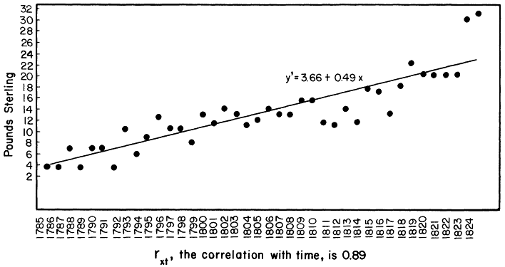
Fig. 4.
Stroud canal dividend series, 1785-1824.
tions, the company sustained a further loss of interest arrears amounting to £75. Altogether, then, subscribers invested an initial capital amounting to £225 per share or £45,000 when all 200 shares of the issue are counted. The total dividend payment over the forty-year period totaled £528.10s. per share, which represented a 235 percent increase in capital. The company protested, however, that the average annual dividend amounted to less than £6 percent per annum; indeed, the time series of dividend payments shown in figure 4, indicates a growth rate or 4.7 percent per annum.
Despite the company's lamentations, such a rate of profit was not unreasonable under then prevailing conditions. In the first fifteen years of the canals' operations (1785-1799), the growth rate in dividends was 8.2 percent per annum, well above the 5 percent interest rate for private lending set by the usury laws.[104] From 1811 to 1824, the trend in the Stroud canal company's dividend payments kept pace with the national movement of canal share prices. The partial correlation coefficient rxy(t) between the two was a strong 0.65.[105] This fact, however, could provide little solace since the rates of profit of most canal companies fell well below the expected 10 to 12 percent per annum.[106] Indeed, the Stroud canals failed to become the major thoroughfare their backers had hoped for. Transport to London proved too slow, sometimes taking up to four months for goods to arrive.[107] Coal and grain seem to have been the only important items carried to the inland settlements and at irritatingly high costs. Although the canals helped to effect the regionalization of local society, slower regional economic growth, revealed by their rates of profit, meant that the landscape remained untrammeled. Implementation of the railway eventually eclipsed the Stroud canals, but its effect on the regional economy and lanscape was hardly more revolutionary.
Both the slowness and high cost of water transport led many clothiers to advocate construction of the Great Western Railway. The line would run between Gloucester and Swindon via Stroud and would link up to the main Bristol-London trunk. Threats to promote such a scheme were made in 1824 and 1831,[108] but no serious action was taken until 1834. In that year an important meeting was held at Stroud to consider public endorsement for building the railway; those attending "represented the most con-
siderable part of the wealth and influence of the neighborhood."[109] Because of sharpening competition with the North of England in textiles and the promise of further development of the region's resources, especially coal,[110] the project was given a unanimous vote of confidence. Moreover, the railway provided a significant investment opportunity for individuals. "Looking at it as a matter of investment," one speaker had commented, "if it paid only £6 percent, it might be considered a pretty good speculation. . . . The £100 shares [issued] were now producing £200." Nor was it expected that the burden of raising capital would fall entirely on the shareholders, who were not held bound to their subscriptions until all shares were sold, and the government promised assistance to the extent of half the needed capital at only 4 percent interest.
Despite these liberal terms, and apparent enthusiasm for the project, the railway was not completed until 1845.[111] Delays were probably caused by the resistance of landowners whose properties lay along the proposed route,[112] and by competition between promoters of the Bristol-London and Southampton-London lines; the latter would have bypassed the Stroud region entirely.[113] In addition, there may have been greater skepticism toward the scheme than was apparent at the Stroud meeting. Although several speakers emphasized the importance of the railway for industrial development, one of the principal promoters clearly regarded passenger service as its primary advantage. His attitude, while generally optimistic, may have caused potential investors to doubt the long-term viability of the enterprise.
One indication of such resistance was the failure to consider construction of branch lines from the proposed Gloucester-Swindon trunk to the inland areas. W. H. Hyett, MP (Member of Parliament) for Stroud, confidently maintained that there would be little difficulty establishing such lines in the future. Yet the only branch in the region, from Stonehouse to Nailsworth, was not constructed until 1867,[114] ostensibly because of the scattered settlement pattern of the district.
This difficulty had been cited as the main obstacle a decade earlier in a debate at the Nailsworth Literary and Mechanics Institute. "Nothing short of an indefinite number of stations," one speaker contended, "would be much if any service to the inhabitants" and
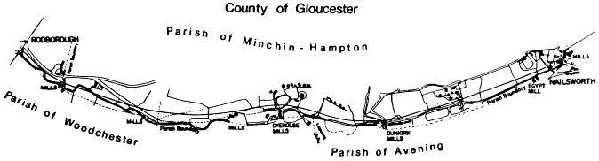
Map 4.
Stonehouse-Nailsworth Branch Railroad Line, ca. 1863. Source: Gloucester Records Office Q/RUM 304.
therefore of limited profitability.[115] Certainly he had exaggerated the problem. When finally built, the section of the line from Stone-house to Rodborough, depicted in map 4, provided full service to mill owners on the south side of Stroudwater canal; and the section from Rodborough, running south to Nailsworth, passed close to the mills along the Nailsworth stream. Yet implementation of the railway did little to arrest Stroud's economic decline. Unlike Birmingham, with which contemporaries often drew contrasts,[116] the Stroud region never urbanized significantly and therefore retained its rural character.