Domesday Resources: Their Extent and Management
Peterborough Abbey rebounded after its refoundation. It enjoyed a comparable range of resources, but managed them no longer as a territorial unit but through manors scattered in the landscape. Between the Domesday survey in 1086 and the survey of 1125 the Abbey had subinfeudated some properties.[32] The following discussion considers only those properties over which the Abbey retained control in the Domesday generation.[33] Figures 2 and 3 show the locations of the Abbey's manors.
The Setting of the Domesday Manors
The eastern perimeters of the estate of Peterborough Abbey in the Domesday generation extended into the adjacent peat fens. The monasteries of Peterborough, Thorney, Crowland, and Ramsey did not fight for sharp definition of their fen boundaries until the thirteenth century.[34] The river Nene bounded the estate to the south. Several manors (Boroughbury, Castor, Fletton, Alwalton, Warmington, Oundle, Irthlingborough) hugged its banks. To the west, the Welland River formed an estate boundary. Northern holdings of the estate lay along transportation routes to the town of Lincoln and to the north. This slice of the East Midlands defined by the scattered manors of Peterborough Abbey roughly coincided with the Mercian territory over which it had wielded power. The ecology of its agrarian
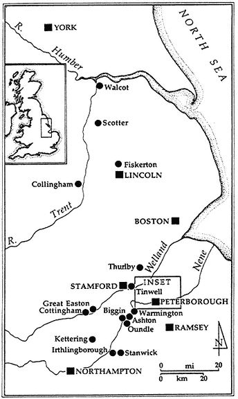
Fig. 2.
The twelfth-century estate of Peterborough Abbey. The manors controlled by the
Abbey are marked with circles, except for the home manors of the Abbey, which
are represented in the inset map.
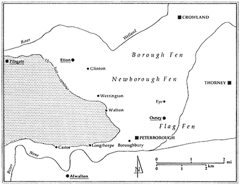
Fig. 3.
Inset Map: The home manors and vaccary at Oxney surveyed in the twelfth century are represented by circles.
For the places underlined—Pilsgate, Etton, and Oxney—there are no manorial accounts in the early fourteenth century.
lordship, control over fen, river meadows, woodlands, and diverse soil-types, had not altered radically.
Fen
From the eastern borders of the monastic precincts the peat fen stretched to the horizon. The Abbey's home manor of Boroughbury and the manors of Glinton, Werrington, and Walton lay along the margin of the fen on the slightly elevated gravel terraces of the river Nene (6-21 m OD). Within the fen the manor of Eye and the cell at Oxney, resting on gravel and clay ridges, rose as islands above the surrounding peat.
The classification of peat fen as a pastoral resource depends upon the history of its local management. Fen vegetation is as sensitive as woodland to human intervention.[35] During dry periods unmanaged peat fen reverts to a dense growth of brush and small trees, a vegetation known as carr. Typically, the woody growth is composed of alder (Alnus ), ash (Fraxinus ), hazel (Corylus ), buckthorn (Rhamnus catharticus ), elm (Ulmus ), dogwood (Cornus sanguineus ), raspberry (Rubus idaeus ), and oak (Quercus ). The ground surface of brushwood-peat or carr is firm enough for the tread of livestock. The habitats of fen-edge woodland and carr, therefore, do not differ radically as rough forage. When fen carr grows dense, it becomes impenetrable to cattle, sheep, and horses, thus diminishing its use as rough pasture. Only pigs, with their ability to crash through bush, benefit from foraging on the herbaceous ground cover of dense carr.
Grazing and mowing effectively coax fen's botanical succession away from dense carr and enhance the growth of reeds and rushes, vegetation commonly associated with fen flora.[36] Regular cropping at intervals of one to two years and four to five years respectively maintains the mixed sedge (Cladio -Molinetum ) and litter (Molinetum ) habitats characteristic of mown fen. Under wet conditions—and the medieval fenland grew wetter over the thirteenth and fourteenth centuries—peat fen reverts to reed swamp (Phragmitetum ) and pure sedge (Cladietum ). Drainage can deflect succession to such swampy conditions.[37]
The Domesday Book ignores the Abbey's fen resources.[38] It recorded only 140 acres (57 ha) of meadow for the Abbey's fen-edge manors of Boroughbury, Glinton, and Werrington. In the eighteenth
century the antiquarian John Bridges estimated that the common fen, Borough Great Fen, adjoining Peterborough, measured six thousand acres (2,429 ha), and the Victoria County History records half that acreage.[39]
The 1125 survey fails to evaluate either fen or meadow resources. It does, however, list labor services. Those required of peasants living along the fen-edge reveal aspects of fen management in the early twelfth century. Peasants on the manors of Glinton, Walton, and Werrington rendered carriages of rushes (junci ) to the Abbey. Such renders show that the Abbey's peasants mowed fen on a four-to-five-year cycle. Peasants on the manors of Werrington and Walton carried carriages of fodder (herbae ) to the Abbey. A shorter mowing regime of one to two years produced the mixed sedge (Cladio -Molinetum ), typical fen fodder. The labor services show that the Abbey relied on its peasants to mow parts of the fen on regular cycles of different rhythms to produce different fodder crops. Some of the renders listed in the 1125 survey also hint at the use of other fen resources, such as water birds. The Abbey received ducks and geese from peasants in the manor of Glinton, the only manor listed with a fowler in 1125.
As a fen landlord the Abbey also enjoyed the products of fish and eels from the fen rivers and streams. The Domesday Book states that the Abbey had one boat on Whittlesey Mere, the largest freshwater lake in England until its drainage in 1851.[40] The Abbot had sublet another boat, a fishery, and fisherman from Thorney Abbey in exchange for wood and pigs from the upland behind Peterborough. The Domesday survey valued at eighty shillings a fen fishery belonging to Peterborough Abbey, a value that exceeded any one of its mills, markets, or woodlands. The 1125 survey reveals much less about the Abbey's fisheries. It reports only that the Abbot collected fifteen shillings in fish from three fishermen in Boroughbury and six shillings for a fishery in Glinton.
Neither survey accounts for the vast quantities of fen eels collected by the Abbey, which other documents mention. According to a tenth-century foundation charter of the neighboring Abbey of Thorney, Peterborough Abbey was entitled to eight thousand eels from the fen fisheries at Upwell, Outwell, and Elm located east of Peterborough, near Wisbech.[41] These eel renders came from locations that once stood at the edge of the more extensive fen territories attached to the
Mercian estate of Peterborough Abbey. Their collection probably harks back to earlier territorial arrangements.
The written sources offer only a fragmentary picture of the Abbey's fen management. The scale and intensity of the Abbey's utilization of the fen remains uncertain. Statistics for the Abbey's demesne livestock recorded in the survey of 1125 (to be discussed further in chapter 2) do not suggest that its dairying or sheepherding, which would later dominate the fen and fen-edge, had developed much beyond small-scale production in the early twelfth century. Perhaps underutilization of its fen resources contributed to their absence from valuations of the estate. Some producers, however, must have supplied the nearby looms of Stamford textile industry with wool and Stamford households with food.[42] The written documents tell us even less about the utilization of local fen resources by the Abbey's peasants.
Meadow
The manors of Peterborough Abbey enjoyed good riverside locations that provided the estate with 1,515 acres (613 ha) of Domesday meadows.[43] Geographically the Abbey's holdings of assessed meadowlands were quite dispersed. The greatest concentration of meadow resources lay furthest from the Abbey. Its more distant manors, which served as staging points to the north (Thurlby, Collingham, Fiskerton, Scotter, Walcot), possessed 61.4 percent (930 acres) of the assessed holdings.[44] Its home manors (Boroughbury, Longthorpe, Castor, Glinton, Werrington, Pilsgate, Fletton) husbanded only 17.8 percent (271 acres) of assessed meadow. Slightly less than a quarter of the Abbey's assessed meadows lay on its western Northamptonshire manors. Figures 4 and 5 show the distribution of meadow on the Abbey's estate.
Medieval farmers usually mowed meadows for hay. From mid-December to early summer, they enclosed meadows to protect the production of the hay crop. They mowed the hay from mid-June to July. Then, depending on management, livestock grazed the mown meadows, unless a second hay crop was to be taken in late August.
Farmers can also choose to graze meadows with their stock rather than mow them.[45] The decision to mow or graze riverside meadows depends on seasonal strategies of matching livestock populations with
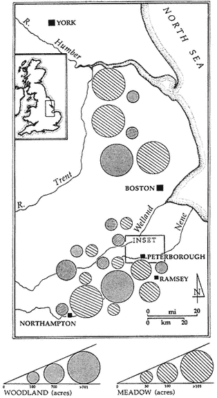
Fig. 4
Fig. 5
Figs. 4 and 5.
The meadow and woodland resources of the Abbey recorded in the Domesday Book.
pastoral resources. Mowing and storage of hay for winter fodder implies a pastoral economy where the number of animals exceeds winter pasture and one in which movements of livestock can be coordinated with storage locations. If farmers graze meadows in the summer, they must store some other source of fodder for the winter or move the animals to winter pasture. The decision to mow or graze depends, too, on who controls the resource and on the demands of the livestock economy. Medieval farmers usually restricted the grazing of alluvial meadows to cows and horses. Dairy cows, in particular, had special need to feed on the early spring flush sprouting in alluvial meadows, when other forage was scarce.
Low-lying river-meadows can also be managed as water meadows by constructing a system of drains, weirs, and channels. Archaeologists have found evidence of water meadows in late Saxon Winchester.[46] Water meadows are usually associated with sheep farming. The sheep, especially ewes, are let on the irrigated meadow in March and April to graze on the spring flush. They are then removed to allow irrigation for a July hay crop. Livestock then grazed the new growth of late summer, the aftermath.
The Domesday survey assesses meadow acreage on the estate, without comment on its management. The 1125 survey rarely mentions meadow acreage or meadow-related activities such as mowing in its list of peasant services. At Kettering the survey does mention extra meadow worth fifteen shillings. To give a comparative value for this figure, 6,048 acres (2,419 ha) of stocked (oneratur ) woodland at Oundle in 1086 were valued at twenty-five shillings. Tinwell also had extra meadow valued at six shillings. Extra hay (et de feno de super plus ) valued at six shillings is reported at Great Easton. When the 1125 survey does record mowing services, they are owed usually by the Abbey's sokemen. At Glinton and Fiskerton, sokemen mowed and carted hay one day for the Abbot.
The Domesday survey did not record demesne or peasant livestock on the Abbey's manors. The 1125 survey lists demesne livestock and the number of peasant ploughs on many of the manors. Only the weakest associations between the numbers of demesne oxen, or the estimated number of peasant oxen, or the total of demesne and peasant oxen and the Domesday meadow acreage can be found when those values are plotted. The estimated number of peasant oxen correlated most closely with meadow acreage, but in this case there was only a 13 percent probability that the correlation was significant. Such statistics belie a linear relation between pastoral resources and tillage on the estate in the early twelfth century.[47]
Woodland
The Abbey controlled nine times more woodland than meadow, according to the Domesday survey. Figures 4 and 5 illustrate the distribution of woodland on the estate. In toto, the Abbey controlled 13,880 acres (5,619 ha) of woodland, which included 1,390 acres (563 ha) of woodland for pannage and 310 acres (125.5 ha) of underwood
in 1086.[48] Its manors in western Northamptonshire, especially those located on the eastern and western edges of Rockingham Forest, had access to over two-thirds (8,814 acres or 63.5 percent of total woodland acreage) of the Abbey's woodland resources. Through its home manors the Abbey controlled another 3,366 acres, or 24.2 percent, of its woodland. On the northern manors, where the Abbey had access to so much meadow, it husbanded only 1,700 acres, or 12.2 percent, of its total woodland resources compared with 61 percent of its meadow.
The Abbey dominated much of the woodland of Northamptonshire, which by 1086 covered only 8.8 percent of that county.[49] According to thirteenth-century surveys, the forest bounds of Rockingham Forest enclosed 16,822 acres (6,729 ha), much of it woodland. In 1086 the Abbey controlled 50 percent of that area through its manors on the perimeter of the forest. By the early twelfth century the Abbey had begun to retain its woodland when it leased its manors (Et abbas tenuit boscum in sua manu ). At Oundle it assarted over 400 acres (162 ha) of woodland by 1189 to create its great cereal grange, La Biggin.[50]
Medieval woodlands were managed as renewable resource.[51] Fellers husbanded an upper tier of woodland, composed of timber or standard trees such as oak, ash, and maple, on a thirty-year cycle, and a lower tier of underwood or coppice, usually sallow (Salex ), oaklings (Quercus ), and hazel (Corylus ), on a seven-to-twenty-one year cycle. The cropped underwood provided faggots for firewood and rods used for weaving wattles for housing, fences, folds, and so on. Underwood also provided raw material for charcoal makers. Such practices kept the woodland in a constant process of reproduction and harvest.
Topographically, grassy swards and heaths for grazing flourished in the mosaic composed of woodland in different stages of regeneration. The requirements of coppicing conflicted, however, with herding pigs on autumn mast, a practice often associated by our textbooks with medieval woodlands. Coppiced plots must be herbivore-proof during their early stages of regeneration, since cattle, pigs, and other browsers can do great damage to new, tender shoots. The small pigherds recorded in the 1125 survey are consistent with a picture of the Abbey as a manager of coppiced woodland and the keeper of pigs on a modest scale.[52]
As the center of a complex household and developer of a monumental building program in the twelfth century, the Abbey con-
sumed timber and other woodland products. From the manors located within a seven-mile radius (11.3 km), it received 129 carriageloads of wood as an annual render from its peasants, who also rendered oats and fowl for their right to collect firewood in the Abbey's woodland. As a rule of thumb one acre (0.40 ha) of twenty-year coppice yields about twenty carriageloads of bulky bundles of firewood.[53] Thus the render represents only about 12.5 acres (5 ha) of coppice ready for harvest. If the Abbey used a ten-year cycle for coppicing, it would have a total area of 125 acres (50 ha) of its woodland under coppice. This measure reflects, of course, the Abbey's customary right to extract wood renders from its tenants and not the total productive capacity of its woodland resources. The woodlands of the Abbey also lay close enough to the town of Stamford to fuel the greedy kilns of the Stamford pottery industry.[54] If the Abbey redirected to Stamford the carriages of firewood collected by its peasants, they would support about three hundred firings.
Arable
As a cereal cultivator the Abbey had its share of good and bad soils. Lighter gravel and drift deposits characteristic of the Nene and Welland river terraces served as an arable focus for most of its Soke and Northamptonshire manors.[55] The higher-lying soils sloping up from the river terraces may be divided into two basic types: (1) lighter soils of limestone, cornbrash, and sand; (2) heavier soils of different clay deposits. Dry, light soils of cornbrash found at Castor, Longthorpe, Alwalton, Pilsgate, and Walton; the Lincolnshire limestones of Cottingham, Tinwell, and Great Easton; and sands at Collingham and Scotter can produce good crops, but their porosity makes them very susceptible to summer drought. Arable in the central part of the Soke, where few streams run off from the Welland and Nene, was particularly vulnerable to dryness.[56] The threat of parched crops reduced the potential value of soils composed of cornbrash and limestone. These dry areas also posed problems for summer pasturing, since herds required convenient sources of water.
The second type of soil, the clays, characterized the higher-lying parts of the manors of Warmington, Oundle, Ashton, Aldwincle, Stanwick, Irthlingborough, Pytchley, and Fiskerton. The tractability of the clays could vary from the lighter clays at Fiskerton to the very
sticky boulder-clays of the middle Nene Valley at Irthlingborough, Oundle, and Aldwincle.
The Domesday survey and the survey of 1125 shed light on the Abbey's management of its arable resources. They record information on demesne and peasant ploughs and labor services owed by the Abbey's peasants. The arable resources of the estate could not be utilized without the labor of the Abbey's tenants; therefore, an analysis of those labor services opens discussion of their management.
The Abbey's Peasants and Its Use of Their Resources
The basic pattern of peasant labor services rendered on the estate was already in place in the early twelfth century.[57] Topographical studies of Northamptonshire charters show that the headlands and furrows of field systems had extended to parish boundaries by the twelfth century.[58] The agrarian landscape had taken on its medieval shape, and lordship had staked its claims to human resources within this developed landscape. In what ways had labor services become part of the political ecology of the estate of Peterborough Abbey?
Peasants owed week work and ploughing services to the Abbey. Ploughing services were a greater capital investment for the peasant, since they required not only their time but their ploughs and plough animals. The survey of 1125 defines ploughing services differently on different manors of the estate. On some manors ploughs of the village appeared for the Abbey a specified number of times for winter, spring, summer, and fallow ploughings; or the ploughs had to plough so many acres. Sometimes these types of ploughing services were combined on manors.
When ploughing services were expressed in acres, a virgater commonly had to plough one acre. At Eye and Boroughbury, tenants had to plough two acres and four acres respectively. The Abbot also reserved the right to call for ploughing boons (precaria ), or days where all ploughs were expected to work for him, at his call. The number of precaria owed to the lord varied from manor to manor.
A specific example best illustrates how the Abbey matched human resources with the requirements of managing its arable resources. On the manor of Kettering, the manor with the most peasant ploughs in 1125, and a heavy burden of three days of week work, the Abbey expected twenty-two village ploughs to plough four acres (1.6 ha)
| ||||||||||||||||||||||||||||||||||||||||||||||||||||||||||||||||||||||||||||||||||||||||||||||||||||||||||||||||||||||||||||||||||||||||||||||||||||||||||||||||||||||||||||||||||||||||||||||||||||||||||||||||||||||||||||||||||||||||||||||||||||||||||||||||||||||||||||||||
each for summer sowing. This service amounted to ploughing 88 acres (35.6 ha). The Abbey also required its peasants at Kettering to plough thrice in winter, thrice at the summer sowing, and thrice in the summer. Estimating the amount ploughed per day in the heavier winter and spring ploughing at 3.5 rods, the villagers cultivated then 115.5 acres (46.7 ha).[59] Thus, in total, the Abbey had 225.5 acres (91.3 ha) of demesne ploughed by its peasants at Kettering. This figure comes reasonably close to the sown area of the Kettering demesne over the period 1280-1310 when the Abbey planted a mean acreage of 271 acres (109.7 ha) in a winter-spring rotation of rye and oats.
The Abbey could convert its labor resources into cash as a way of collecting them. The patterns of commutation reflect both management decisions and differences in wealth and demand for labor on individual manors. On those manors where the Abbey had already commuted much peasant labor for cash payments, peasants worked only one or two times a week, except during the busy days of August, and they rarely ploughed. The Abbey charged higher rents per virgate on such manors: Thurbly, 4.12s .; Collingham, 4.00s .; Scotter, 3.18s .; and Fiskerton, 2.67s . As early as the turn of the twelfth century the Abbey decided that cash commutation was cheaper than surveillance when considerable distances were involved. The manors of Scotter (68 miles—110 km), Collingham (49 miles—79 km), and Fiskerton (45 miles—73 km) were each not less than forty-five miles (73 km) distant from the Abbey. Thurlby, located only thirteen miles from the Abbey, is an exception to this rule; but the Abbey viewed Thurlby as part of its staging system to the north and treated it as a northern manor.
These four manors do not exhaust the list of manors with weekly labor services of less than three days. Three other manors, Tinwell, Great Easton, and Fletton, also fell into this category. Peasants on these manors paid middle-range rents of 1.21s ., 0.83s ., and 0.71s . respectively. In addition to two days of week work, peasants at Tinwell owed light ploughing services of one acre (.40 ha) per virgate. Here soil conditions influenced the calculation for commuting labor services. Tinwell was located on lighter soils of the Lincolnshire limestone, and the Abbey itself kept plough teams composed of only six oxen, instead of the normal complement of eight. The rent per virgate at Tinwell is probably lower, since there was less actual labor
in the arable sector to commute. Great Easton and Fletton provide an alternative picture of rent and labor services. Peasants owed light week work, but the Abbot still collected a form of ploughing service that was unique to these two manors. Peasants had to sow a portion of the area that they ploughed with their own seed. The cost of seed increased the cost of ploughing services for peasants and probably accounted for the lower rent per virgate on these two manors.
The remaining manors owed to the Abbey the heavy render of three days of week work. Rents varied from 2.13s ., per virgate to a low of .35s . The variation in rent on manors with three days of labor service may be explained by variations in wealth on the different manors and by differences in the additional labor extracted by the Abbot. For instance, Kettering, with the highest rent of 2.13s . for the manors with heavy week work, has every appearance of being one of the Abbey's wealthiest manors. The forty Kettering villeins are full virgaters, and they had the highest ratio of villeins to villein ploughs (1 : 0.55). Kettering villeins owed no labor services beside week work and ploughing services, according to the 1125 survey. Their high rent reflected their wealth and also masked commuted carrying services. Manors where peasants paid low rent per virgate, such as Glinton (0.35s .), owed heavy carrying services to the Abbey. Peasants at Glinton had to ferry the Abbot where he wished, and for every plough they had to carry three carriages of timber (lignum ) to Peterborough. They also dried two carriages of firewood and transported them to the Abbey. The Abbey collected carrying services from its nearby manors; therefore those rents were lower.
The pattern of labor services recorded in the 1125 survey highlights the Abbots's logic of resource use. By 1125 the Abbey had already established basic expectations for consuming labor services. Within these limits the Abbey could play off collecting them in cash or in actual service. The costs of supervision clearly bothered the Abbey. On those manors some distance to the north, it collected the labor services mostly in their cash equivalent. The Abbey could increase labor services further only by defining the amount of work to be accomplished within a unit of time—a Tayloresque piecework approach—or by defining the given units of time more closely, that is, that a day of work required service from a specified starting time to a specified stopping time.[60] If the Abbey wished to increase its total units of labor service collected, it could do so only by increasing
human resources on the estate. The Abbey's growing need to consume labor would, therefore, affect the demography of its peasantry.