5—
Li Tao-Yüan (d. 527)
Li Tao-yüan was born in Cho District, Fan-yang (in modern Ho-pei), and later inherited his father's title of duke of Yung-ning under the Northern Wei dynasty. Subsequently praised in historical accounts as an upright official, he served in a number of positions, rising to palace commandant of censors. Nevertheless, he earned the enmity of the regional chief of Yung Region, Hsiao Pao-yin, who arranged for him to be sent on a mission and then had him assassinated.
Li had begun traveling while young together with his father and was said to have read widely. He felt that existing accounts of the Chinese world were too rudimentary and sought, in his words, "to identify places through their waterways and, through these places, to preserve antiquity." His work, The Guide to Waterways with Commentary , was unique in its ambition to record the geography of the major areas of China at a time when the country had been politically divided for some two centuries.
The original Guide to Waterways (Shui-ching ) is no longer extant. It was traditionally ascribed to Sang Ch'in of the Han but, following the work of Ch'ing scholars, is now believed to have been written during the Three Kingdoms period. Others, such as Kuo P'u (276–324), appended commentaries to it, but it was the monumental revision by Li Tao-yüan that has survived. Li expanded the length of the original some twenty times into a work of some three hundred thousand characters recording 1,389 rivers. It follows the form exemplified by Guideways Through Mountains and Seas of documenting geographical sites along linear routes—in this case, major rivers and lakes. Yet Li's
methods represent a considerable advance over the primitive materialist, ethnographic, and mythological concerns of this precursor. Employing 437 sources—official histories, philosophical texts, local gazetteers, biographies, epigraphs, as well as supernatural tales, legends, and local songs, all judiciously selected according to the historical standards of his day—he created a compendium of the recorded knowledge of these places. Considered one of the major achievements of prose writing during the Northern Dynasties period, it has also been viewed by later critics such as Liu Hsi-tsai (1813–1881) as the fountainhead of the later travel account. Of particular interest are the sections containing Li's personal observations and evocative descriptions of outstanding landscapes. He can be credited with adding autobiographical perspectives to the impersonal, objective viewpoint of the geographical record. Those sections describing the geography of the north are considered the most accurate and often reflect Li's own observations as a traveler, while sketches of more distant places, such as Shaman Mountain (Wu-shan), are considerably indebted to other writers.
From The Guide to Waterways with Commentary 
Meng's Gate Mountain 
Meng's Gate Mountain (Meng-men-shan) straddles the Yellow River. One half is located in the west of modern Chi District, Shan-hsi, and the other, in the northeast of I-ch'uan District, Shaan-hsi. It is considered the entrance to Dragon Gate (Lung-men), which stands to the south along the river in modern Ho-chin District, Shan-hsi. According to the "Tributes of Yü" chapter in The Book of Documents , the Hsia emperor Yü had a path for the Yellow River cut through these mountains to control the turbulent current. After the river passes through Dragon Gate, its flow is considerably less threatening.
The Yellow River farther flows southward through the western part of Pei-ch'ü District in Ho-tung Province. As the river flows southward, it passes west of Ku-ch'eng in Pei-ch'ü District.[1] Fourteen miles to the west is Windy Mountain.[2] Fourteen miles west of Windy Mountain on
the south side of the river is Meng's Gate Mountain. Guideways Through Mountains and Seas states: "On the heights of Meng's Gate Mountain lie much gold and jade. At its foot are yellow silt and black rock."[3] The Huai-nan-tzu states: "Before the channel through Dragon Gate was dredged and Mount Lü-liang was cut through, the level of the Yellow River was above Meng's Gate. A great overflow went against the current; no hills remained visible, and even high peaks were obliterated. This was called 'The Deluge.' The Great Yü dredged the channel and it was named Meng's Gate."[4] Therefore, The Chronicle of Mu, Son-of-Heaven says that "he went northward on the route through Meng's Gate by the Nine Tributaries."[5] Meng's Gate forms the upper entrance to Dragon Gate. It is a critical point on the river and is also known as Meng's Gate Ford.
This mountain route was first cut through by Yü. The Yellow River has eroded a wide path; its banks are lofty and deep. Slanting cliffs gaze back at the river protectively. Giant boulders are poised on the brink about to fall, yet they remain stable. The ancients had a saying, "Water is not a chisel, yet it can pierce stogie." How true!
In the middle, the currents collide; white mist arises like clouds floating. Travelers who observe this often think they are just being drenched by mist or dew, but upon closer examination they feel quite alarmed. The water forms crashing waves for a length of a myriad hsün and cascades down from a height of a thousand chang : turbulent, overwhelming, all-powerful, as convulsive as mountains leaping skyward. Colossal waves multiply and collapse all the way down to the outlet. So I realized what the philosopher Shen-tzu[6] meant when he wrote that a bamboo raft traveling through Dragon Gate floats by so quickly that a team of fast horses could not catch up to it.[7]
Lotus Mountain 
Lotus Mountain (Hua-shan) stands about 7, 150 feet high in the south of modern Hua-yin District, Shaan-hsi, near modern Hsi-an. It affords á commanding view of the Yellow River at its juncture with the Wei River not far from the strategic T'ung Pass. Under Emperor Wu of the Han, a temple was built about three miles from the mountain's base, where sacrifices were offered to it as the Sacred Mount of the West. It was also the site of numerous other temples, principally Taoist. The Guide to Waterways suggests the origin of its name in its appearance, said to resemble a flower; more specifically, its western-most peak was named "Lotus Flower" (Lien-hua).
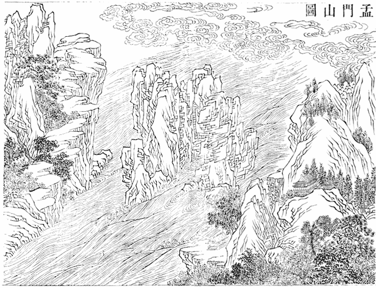
Fig. 12.
Meng's Gate Mountain . From Ku-chin t'u-shu chi-ch'eng (1725), Gest Oriental Library, Princeton University.
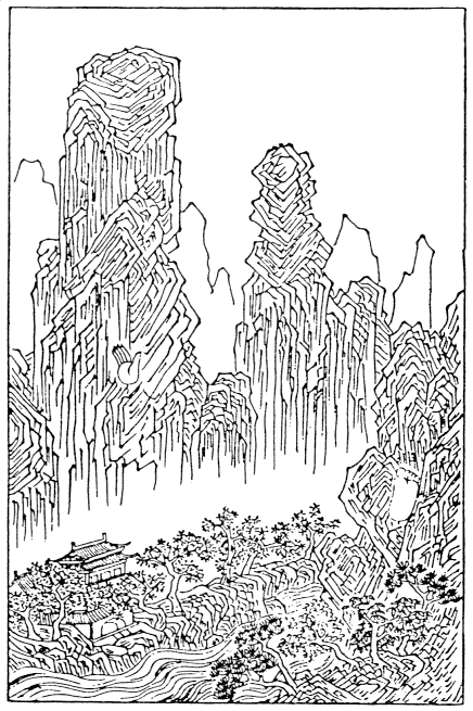
Fig. 13.
Ting Yün-p'eng (1547–ca. 1621), Lotus Mountain . From Ch' eng-shih mo-yüan (l594–
1606), East Asiatic Library, University of California, Berkeley. The hand- and footprints
of Divine Giant on the mountain arc clearly marked. This woodblock print was originally
a design for a scholar's ink-cake by a leading artist of the An-hui school.
Dialogues from the Feudal States by Tso Ch'iu-ming says: "Lotus Mountain, the Sacred Mount, was originally a single mountain blocking the Yellow River, so the water wound about it as it flowed past. The god of the river, Divine Giant, pounding with his hands and stomping with his feet, broke it apart into two, and to this day traces of his hands and feet remain."[1]The Opening Up of Lotus Crag with Illustrations says: "There was an enormous god named Hu who gained complete mastery of the Way of Creation. He could construct mountains and rivers and brought forth the Long and Yellow rivers."[2] This is what "Divine Giant, with his mammoth power, bore as a crown the sacred mountain"[3] means. Often enthusiasts climb Lotus Mountain to observe his imprints here.[4]
From the temple at the foot of the mountain,[5] I passed among numerous junipers and went south four miles; I then turned east for one mile, arriving at the Middle Shrine. Then I went southwest for two miles, arriving at the Southern Shrine, which is called the "Shrine of the Lord of the North." Those who intend to climb the mountain offer prayers for protection to him when they reach this place. From here, I entered southward into a valley and arrived at another shrine, which is named after Guardian Shih-yang, where a rock altar contains a wooden image. Another third of a mile south and I arrived at the Celestial Well.[6] The well can barely accommodate one person: an empty opening, it winds about, turning sharply as I ascended, and is more than sixty feet high. On top of the mountain, there are trickling brooks and slender streams, which flow into the well, but they do not drench people very much. Everyone who climbs must ascend this way, for there is no other path. As I was about to come out: of the well, I glanced toward the sky and saw the light, as if looking through a window from inside a room.
I exited from the well and proceeded southeast for more than half a mile. A high slope was steeply graded up and down. I descended this slope for almost a mile, then turned eastward again and ascended Hundred Chang Cliff. Climbing and descending required grasping onto ropes in order to proceed. I climbed southward for over a mile and reached a rock wall, then slowly advanced along its side for more than one hundred paces. From here, I went southwest for two miles and arrived at another shrine called the Hu-Yüeh Shrine. The statue inside appeared to be that of a youth. From the shrine southward, I crossed over Wedged-in Ridge, which measures a bit more than three feet wide. Flanking it are two suspended cliffs a myriad jen high. I looked down from here but couldn't see the bottom. If a sacrifice at the HuYüeh Shrine produces a response, clouds arise to a level even with it,
and only then should one venture to cross over the ridge. Still, one must mount it prudently, as if on horseback, and sneak over it by advancing gradually; therefore, people call this "Seizing Ridge." I crossed this for almost a mile and finally arrived at the summit.
Just two and a half miles up on the summit are two sacred springs. One is called Reed Pond; it flows westward into a ravine. The other is called Supremely Exalted Spring; it flows eastward into a ravine and then down below. The Temple on the Summit[7] is located close to the northeast corner. Its interior is crammed full with various objects, all of which would be difficult to describe in detail. From the Temple on the Summit, I proceeded northeast 450 paces to where there is a crouching ridge. Then I gazed to the southeast at Divine Giant's Handprint and saw nothing but the reddish wall of a wide cliff; it completely lacked the outlines visible when observed from below.[8]
Three Gorges 
The Three Gorges (San-hsia) of the Long River extend more than 120 miles to form one of China's most scenic travel routes. Ch'ü-t'ang Gorge (Ch'ü-t'ang-hsia), in modern Feng-chieh, Szu-ch'uan, is five miles long; Shaman Gorge (Wu-hsia) extends about twenty-five miles from modern Wu-shan, Szu-ch'uan, to Pa-tung, Hu-pei; and West Mount Gorge (Hsi-ling-hsia) extends some seventy-five miles from Pa-tung to I-ch'ang, Hu-pei. Each forms a distinct landscape and contains many unusual rock formations as well as historical and literary sites. In his description of Shaman Gorge, Li Tao-yüan was heavily indebted to Sheng Hung-chih's A Record of Ching Region (Ching-chou chi ), which he expanded by about two hundred characters. Nevertheless, it was Li's enhanced version that became widely read, and he was regarded as the first writer to describe these now-famous scenes in detail based on his personal observations.
The Long River flows eastward past Broad Stream Gorge[1] —this is the first of the Three Gorges. Along the ten miles of this section are tottering cliffs and slanting trees, whose forms appear about to collide. Up the mountains on the northern bank is the Divine Chasm. North of the chasm is White Salt Crag. It is more than a thousand chang high and overlooks the Divine Chasm. The local people noticed its height and whiteness and thus gave it this name. When there is a drought, trees are burned on top. The ashes are then pushed over, soiling the Divine
Chasm below; before long, rain falls. Ch'ang Ch'ü said that in this district there is a god of water in the marshes by the mountains.[2] In times of drought, drums are beaten to ask for rain, and he always responds with a beneficent rainfall. This is what is meant by "He responded to the sounding drums and sent rain" in the "Rhapsody on the Capital of Shu."[3]
In this gorge are two rapids—Ch'ü-t'ang and Yellow Shrine. Their currents swirl around and back in summer. They are disliked by those navigating up and down stream. There is a temple at Ch'ü-t'ang Rapids that is noted for its spiritual power. When regional inspectors and court officials with salaries of two thousand tan passed by, no horns or drums were permitted. When traveling merchants journeyed against the current, they feared making noise when scraping up against the rocks, so the boatmen covered the ends of their poles with cloth. Now such poles are no longer used; instead, offerings of' food are made without a break. There are many gibbons in this gorge. They do not naturally live anywhere along the northern banks. They may have been captured and placed in the northern mountains, for originally, no sounds of them were heard. Perhaps, like the badger, they crossed the Min River,[4] for the badger, too, does not naturally live here. This gorge was dug by Yü in antiquity as a passageway for the Long River, for Kuo Ching-ch'un says, "The gorges of Eastern Pa were cut by the Hsia Emperor."[5]
The Long River farther flows eastward past Shaman Gorge, which Tu Yü cut as a passage for it.[6] Kuo Chung-ch'an said, "According to the 'Treatise on Geography': 'Shaman Mountain is located in the southwest of the district,' but now it is east of the district town, perhaps because the district government has not remained in the same location."[7]
The Long River proceeds through the gorge, passing eastward by Newly Collapsed Rapids. This mountain collapsed in the twelfth year of the Yung-yüan era of Emperor Ho of the Han [100] and collapsed further in the second year of the T'ai-yüan era of the Chin [377]. When it did, the water reversed course for more than thirty miles and rose several hundred feet high. Nowadays, there are rocks in the rapids; some are cylindrical like rolled-up bamboo mats, some are square like houses. There are many like this, all of which fell from the collapsing mountain, and the water becomes ferocious here, flowing by swiftly.
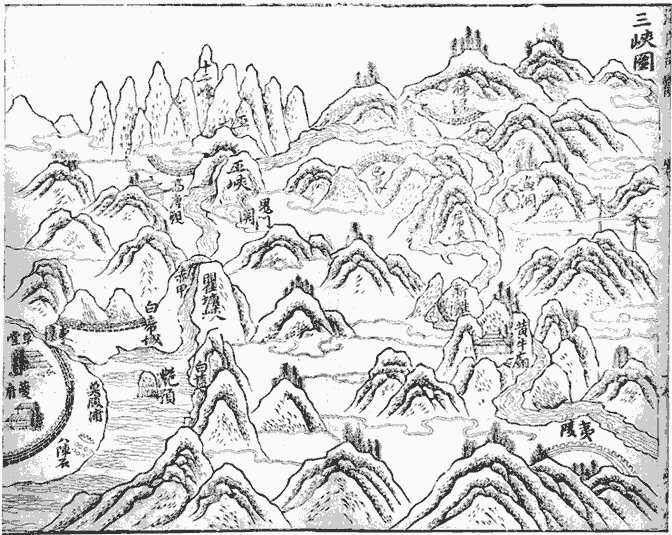
Fig. 14.
The Three Gorges . From Hai-nei ch'i-kuan (1610), Deutsche Staatsbibliothek, Berlin.
Thus it is called "Newly Collapsed Rapids." What remain of the toppled cliffs are still taller and more majestic than the other hills around.
More than three miles downstream is Great Shaman Mountain. Not only is it without peer among the Three Gorges, it could contest the height of Min and Eyebrows mountains and is a match for Transverse Mountain and Nine Similar Peaks.[8] Its wings connect with numerous other mountains, and it encompasses the azure clouds; moreover, along with the empyrean, it passes judgment on the height of everything else. It is where the god Meng T'u dwells. The Guideways Through Mountains and Seas states: "Meng T'u, an official of the Hsia emperor Ch'i, was appointed as a god in Pa. Some people of Pa brought a criminal accusation before him, but among them was one who had bloodstains on his clothes, so Meng T'u arrested him. Meng T'u was then asked to take up residence on this mountain, which is west of Cinnabar Mountain."[9] Kuo Ching-ch'un said, "Cinnabar Mountain is in Tan-yang which was part of Pa. 'West of Cinnabar Mountain' refers to 'Shaman Mountain.'"[10] In addition, the Celestial Princess dwells here. Sung Yü referred to her as the youngest daughter of the Celestial Emperor, named Yao-chi, who died before she was married. She was enfeoffed with the southern slope of Shaman Mountain, where the essence of her soul became the plants and the fruit became divine fungi.[11] Thus she stated, "'I, the maiden of Shaman Mountain, become clouds in the morning and rain in the evening by Kao-t'ang Belvedere, morning after morning, evening after evening, below the Southern Terrace.' When the king of Ch'u arose early to view it, he found it was just as she said. Thus he built a temple there and called it 'Morning Clouds.'"[12] From beginning to end, for fifty-five miles, this place is known as Shaman Gorge, taking its name from the mountain.
For the two hundred forty miles of the Three Gorges, mountains stretch along both banks without break. Layers of peaks, ridges upon ridges, hide the sky and block out the sun. Midday and midnight are the only times the sun and moon become visible. When summer arrives, the level of the water rises up the hillside so that the boats are prevented from traveling upstream and downstream. Sometimes, when the Emperor issues an urgent decree, it is possible to set out from the White Emperor's Citadel[13] in the morning and arrive in Chiang-ling by evening.[14] For the four-hundred-mile journey, riding a swift horse or flying on the wind cannot match the speed of a boat!
When winter turns to spring, there are white torrents and emerald depths; reflections appear upside down in the swirling eddies. Many oddly shaped junipers grow forth from jagged mountain peaks from
which waterfalls plummet clamorously. Pure, verdant, lofty, flourishing—such qualities provide innumerable kinds of fascination. After a storm has cleared, or on frosty mornings, among forests chilled and streams desolate, the loud cry of a gibbon is often heard, prolonged and mournful. As it echoes through the empty valleys, its despairing wail lingers before disappearing. So the fishermen sing,
Of the Three Gorges in Eastern Pa[15]
Shaman Gorge is the longest.
Three cries of the gibbon
and one's clothes become drenched with tears.[16]
The Long River flows farther eastward, past Wolf's Tail Rapids and by Men Rapids. Yüan Shan-sung said, "These two rapids are almost a mile apart. The water at Men Rapids is formidable and treacherous. The south bank contains granite rocks that are submerged in summer but emerge in winter. These rocks tower above. For several tens of paces, they form the shape of men's faces, some large, some small. And some are so clearly defined that even whiskers and hair arc distinguishable. Thus it is called 'Men Rapids.'"[17]
The Long River flows farther eastward, past the foot of Ox Mountain, where there is a rapids named "Ox Rapids." On the southern bank, layers of ridges rise up with tall cliffs interspersed by the riverbank. There is a rock whose colored surface resembles a man carrying a sword on his back as he leads an ox. The man is in black, and the ox in yellow, clearly defined. Since there is no way to reach it, one cannot investigate it closely. This cliff is quite high, and in addition, the current is swift and winding; one can continue to view this phenomenon while traveling for two days along this route. Therefore, travelers sing a song which goes,
Mornings, we set out from the Ox;
Evenings, we spend by the Ox.
For three mornings and three evenings,
The Ox stays the same.
It means that the route twists around as it progresses, so the view seems to remain unchanged.
The Long River flows farther eastward past West Mount Gorge. A Record of I-tu says,
As one enters from Ox Rapids eastward into the area of West Mount Gorge, it is more than thirty miles to the mouth of the gorge. Both the mountains and the water twist and turn, while along both banks are tall mountains forming layers of screens. Only at noon and at midnight can one see the sun and the moon. The sheer cliffs may be more than a thousand chang high. The color of the rocks and their shapes, for the most part, resemble various kinds of things. The trees are tall and flourishing and generally endure the winter. The cries of gibbons are quite clear and echo through the valleys, vividly and without cease. This is one of what is known as the "Three Gorges."[18]
Yüan Shan-sung stated that he had often heard of the perilous water throughout the gorges. All the written records and oral accounts cautioned travelers and warned them—none ever praised the beauty of the scenery. Then I came to visit this area. After arriving, I happily realized that hearing is not as good as personally observing. Its layered crags and graceful peaks, of unique construction and unusual shape, are indeed difficult to describe. Its forests and trees form intricate woods, randomly rooted and densely flourishing, which protrude above the mists. As I gazed up and peered down, it grew ever more familiar and ever more beautiful. I lingered and spent two nights there, forgetting about returning. For what I saw with my own eyes was a sight hitherto unknown to me. I am delighted to have experienced these unique sights. And if this landscape has a soul, it ought to be surprised to find that it has finally encountered a true admirer for the first time in history.[19]