Synoptic-Scale Circulation
Weather Regimes
Figure 1.1 shows the principal airflow patterns and air-mass types or source regions that determine regional weather in different seasons of the year. The arrows indicate the directions of air movement near and above the crest of the major mountain ranges, at levels between 10,000 and 20,000 ft (3 to 6 km) above sea level. The open circles are locations from which twice-daily (near 4 A.M. and 4 P.M. PST) rawinsonde balloon ascents are made to obtain data on air temperature, humidity, and wind velocity, from which upper-air (e.g., 500 mb) weather maps are plotted and analyzed. The black circle indicates the location of the Bishop Airport, the nearest (3 mi, or 5 km) National Weather Service station to the White-Inyo Range.
The air that flows across California at any time of year is most likely to have passed over some part of the Pacific Ocean. In summer the Pacific Anticyclone (a large, slow-moving clockwise whirl of air) lies just west of California, bringing an onshore flow of cool marine air, stratus clouds, and fog to the coast and mostly clear, dry air to the Sierra and White-Inyo Range. During much of the summer the Great Basin Anticyclone develops over the warm plateau region of Nevada and Utah. When this whirl expands and shifts westward, a flow of moist maritime tropical air from the Gulf of California or the Gulf of Mexico may persist for a few days before the normally dry Pacific flow reasserts itself. Thus, during the summer season the mountainous terrain of eastern California and western Nevada is contested for by two air masses, with that from the northern or central Pacific usually prevailing.
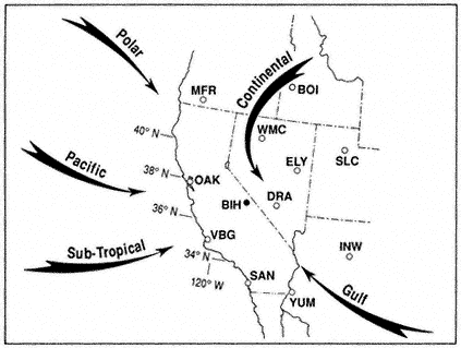
Figure 1.1
Major airflow patterns and air mass types affecting California and the Great
Basin. Rawinsonde stations shown are:
| ||||||||||||||||||||||||||||
During fall, winter, and spring a series of traveling upper-air troughs (cyclonic bends with counterclockwise flow) and ridges (anticyclonic bends with clockwise flow) cross California and Nevada. Ridges and anticyclones usually bring subsiding air, few clouds, and "fair" weather, whereas the troughs and associated cyclones, low-pressure centers, and fronts bring much cloudiness and widespread precipitation. Fronts are boundaries between converging air masses from different source regions. The primary air masses affecting California are cold maritime polar air from the Gulf of Alaska and warmer, moist maritime subtropical air from lower latitudes. Occasionally there are invasions of cold continental polar air from northern Canada or the Rocky Mountains.
Seasonal Storms
Cloud formation and precipitation result primarily from ascending motion in moist air. When air rises, it expands and cools. This causes its invisible water vapor to
condense, forming small cloud droplets. As the ascending motion continues, the clouds thicken and the droplets grow larger to form raindrops. If it is sufficiently below freezing (32°F, or 0°C), snow crystals form, which, when heavy enough, fall from the clouds and reach the ground as rain or snow. The precipitation that falls on the mountains each year is a result of four principal mechanisms of upward-moving air: general ascent produced by widespread horizontal convergence in cyclonic flow, more intense lifting in frontal zones, strong "orographic," or terrain-induced, lifting over the windward slopes of mountains, and thermal convective instability triggered by the ascending motion, which causes the cloud to billow upward and precipitate with greater intensity. Although heavy precipitation (40 to 80 in or 100 to 200 cm of water annually) falls on the upper western slope of the Sierra, the region immediately leeward, including the Owens Valley, the White-Inyo Range, and much of western Nevada, is in the so-called rain shadow of the Sierra and receives much less precipitation. The drying of the air results from both the loss of moisture due to precipitation on the windward slope and the adiabatic warming induced by descent over the leeward slope.
Cold fronts, moving in such a way that cold air replaces warmer air at the surface, usually approach from the northwest or the west. Before the passage of the front and its lagging upper-air trough, the airflow across the mountains is from the west or southwest, while surface winds in the valleys and basins are mild and from the south. After frontal passage the upper flow becomes northwesterly to northerly, and cold northerly to northeasterly winds sweep across the mountain ridges and along the valleys. The Sierra Nevada has a profound effect on most fronts, causing them to stall west of the crest while their northern sectors move more rapidly across Oregon and then southward over northern Nevada. Thus, many fronts converge on the Sierra Nevada and White-Inyo Range in nutcracker fashion, with the cold air reaching the leeward valleys and basins from the north before the cold air from the west can surmount the High Sierra.
When a surface low-pressure center forms in western Nevada accompanied by an upper trough that deepens excessively to form a cyclone over the region — a weather pattern known locally as a "Tonopah low" — a northeasterly to southeasterly flow often brings continental polar air or recycled maritime polar air, low clouds, and snowfall to the White-Inyo Range. When such storms involve moist Pacific air, they usually bring heavy snowfall to the region; some of the biggest snowstorms recorded in the White Mountains have occurred in such circulation patterns. Precipitation from closed cyclones over the region is most frequent in spring, resulting in a spring (April or May) precipitation maximum in much of the Great Basin, in contrast to the pronounced winter maximum in the Sierra Nevada.
On infrequent occasions, usually several years apart (e.g., January 1937, January 1949, December 1972, February 1989, and December 1990), a long northerly fetch of air may bring an invasion of true Arctic air from interior Alaska or the Yukon. These episodes bring record cold temperatures to the White-Inyo Range and adjacent valleys; at such times minimum temperatures may dip to -25°F (-31°C) or below.
Most winters include one or two episodes of "warm storms," periods of a few to several days in which very moist tropical air reaches California from the vicinity of Hawaii. In these events the freezing level may be above 10,000 ft (3,000 m), and the heavy rainfall may result in widespread flooding in much of California. It is during such storms that heavy rime icing may form on trees, structures, and power lines on high mountain ridges. This is caused by the combined effect of strong winds and supercooled clouds (composed of water droplets at air temperatures below freezing). The cloud droplets freeze on contact, building great formations of ice that grow into the direction of the wind.
Conversely, "cold storms" bring snow to low elevations, including the floor of Owen Valley and desert areas to the south and east of the White-Inyo Range. Major westerly storms that last for two or three days bring heavy accumulations of snow — a foot (30 cm) or more in the valleys, and two or three times as much at the highest elevations. Very cold storms from the northwest contain less water vapor, are of shorter duration, and usually bring only a few inches (several centimeters) of snow.