II
Habiter Athènes, Corinthe, Sienne ou Amsterdam, c'est habiter un discours. . . . La ville est un langage.
Jean Duvignaud, Lieux et non lieux
To inhabit Athens, Corinth, Siena or Amsterdam is to inhabit a discourse. . . . The city is a language.
That streets should have names is not self-evident. For centuries, most villages and towns felt no need to name their streets, and even today a major urban center like Tokyo manages to do without them. The rethinking of urban space entailed by the naming of streets suggests a relatively extensive geographical area, a population of a certain density, and a varyingly complex array of social and commercial activities. Street names were one outcome of this (re)conceptualization of the urban whole. The debates over street names during the Revolution became so strident because the monarchy had so strongly marked the Parisian text. Rewriting that text to make the city consonant with revolutionary ideals was an enterprise all the more fraught with conflict because the monarchical text proved impossible to efface. Contrary to the way the American revolutionaries were able to proceed at about the same time when they built a capital city from the ground up, French revolutionaries had to contend with the past on every corner.
In their beginnings many towns made do with one or a very few names—la Grande Rue, la Petite Rue, la Rue Basse, la Rue Haute, or, in early American settlements, the inevitable Main Street. Street
names became general in Paris beginning in the twelfth century, but elsewhere in France the written record indicates few names before the thirteenth century. No other city at the time came close to the population of Paris. By the end of the thirteenth century, the city could boast over two hundred thousand inhabitants and over three hundred streets—three hundred ten "real streets" according to the testimony of Guillot's poem Le Dit des rues de Paris.[3]
How were these early streets designated? As in older cities generally, streets in medieval Paris bore "local" or descriptive names, that is, names that made some sort of connection to the site. Consider the following names in Paris and their often tangled origins:
Location—Contrescarpe (on an escarpment), Saint-Denis (the road leading north to Saint-Denis), Grève (near the bank, i.e., la grève, of the Seine)
Topography—Rosiers (rose bushes), Serpente (serpentine street), Pavée (paved, therefore remarkable)
A building or domain—Louvre, Monnaie (the mint), Notre-Dame; or owners thereof—Capucines (Capucin monks), Croulebarbe
Merchandise sold or trade exercised—Mégisserie (tanneries), Ferronerie (ironmongers), Verrerie (glassmakers)
A store sign—Epée-de-bois (wooden sword), Croissant (crescent moon)
Inhabitants—Anglais (English scholars in the Latin Quarter), Mauvais Garcons ("bad boys" or ruffians), Grande Truanderie (big-time ruffians and criminals).
These often colorful names satisfy on several levels. The evident link between name and space renders the name essential, a manifestation, as it were, of the space. The name justified the space, which in turn authorized the name. In the perfectly harmonious world these connections implied, signifier corresponded to signified, sign coincided with referent.
The evident connection between name and place enabled another, between place and history. In their original form, such names were so many features of a genuine popular culture. The users, that is, the inhabitants, took care of the names. But when another generation of users took over, street names shifted to reflect their use of the space.
Orality makes popular culture singularly unstable, so that until street names entered the written record, they were subject to the vicissitudes of population movement and topographical alteration and to the vagaries of human memory. Semantic corruption set in almost as soon as the original basis for the name vanished.
The name that we see on the street today may have no connotative connection to the original, despite the tales that may be (and usually are) advanced to sustain a connection. In the Paris of the thirteenth century, the street Gilles-Queux told of an important inhabitant, Guile-Queux, that is, Guy the Cook. Without the cook and his cooking to anchor the name, Gui-le-Queux turned into Gille-le-Cueur, which metamorposed into Gilles-Coeur (Gille Heart), then to its present name, Gît-le-Coeur (Here-lies-the-heart), the last generating innumerable stories about a putative mistress of Henri IV who supposedly lived there when the name entered the written record. Egyptienne, taken from the chapel of Sainte-Marie l'Egyptienne, became Gibecienne and later Jussienne; and among the most savory, Pute-y-muse (Whores' Walk) became the Petit-Musc (Little Musk) that we come upon in the fourth arrondissement today.
The list could go on and on. Moreover, so strong was the sense of placement, so powerful the belief that word and object ought to correspond, that early chroniclers of Paris made a point of tracing back through topographical and semantic changes to reestablish the authentic connection. By the early fifteenth century there was already a need to set the record straight. The historian Guillebert de Metz, for example, had frequent recourse to the phrase "properly speaking" to disentangle the subsequent narratives and establish what he determined were the true origins of certain Paris street names.[4]
The expansion of Paris occurred along with the consolidation of the French monarchy. Indeed, royal appropriation of the city marked the entry of Paris into the modern age. Street names were its insignia, yet another sign of royal power, a means of impressing dominion on topography itself. The force of the revolutionary reaction on the streets a century and a half later was very much a function of this initial exercise of what can be taken as symbolic eminent domain, the creation of a "sacred geography" designated by and dedicated to the monarchy. This sacred geography was at the same time a "landscape of power" that inscribed the power relations of the larger society.[5]
The ascendancy of Paris took a decisive turn with the decision of François I to settle in Paris. In 1528 the impecunious king notified his "Very Dear and Well Loved Friends" in the rich municipality that his intention from then on was to reside in "our good city of Paris" more than in any other part of the kingdom. To this effect, the Louvre was to be repaired and made fit for royal habitation.[6] Once the definitive conquest of Paris seventy years later ended the wars of religion, the first Bourbon king, Henri IV (1594-1610), went about making his Paris the symbolic center of a reunited France. He and his energetic minister Sully launched the first Parisian urban renewal, building some sixty-eight new streets and developing whole new areas, most spectacularly the Place Royale (now the Place des Vosges) and the Place Dauphine on the Ile de la Cité.
Fittingly, it was Henri IV who introduced the honorific model of topographical nomination, which removed nominatory powers from the users to the government, where they have resided ever since. As it reached further and further into the quotidian, the state assumed the expression and almost the constitution of a collective consciousness. The new streets of the new Paris confined their honors to the royal family: the rue Christine, named for the daughter of Henri IV and Marie de Médicis; the rue and the Place Dauphine, for the then Dauphin, Louis XIII; and at one remove, the rue Sainte-Anne, named for the patron of the queen, Anne of Austria. Aristocrats close to the Crown might fall under the royal mantle of honorific recognition (the rues Richelieu, Mazarine, Vendôme, Colbert), as did certain especially important entrepreneurs who opened new sections of the city (the rues Charlot and Villedo, the Pont Marie). Glorious happenings completed the roster of nominatory possibilities (Place des Victoires, and Place des Conquêtes for the Place Vendôme). In the eighteenth century, the municipality added city officials (the rues Vivienne and Feydeau, the quai d'Orsay). But though those honored came to include "lesser" individuals, dispensing that honor remained a royal prerogative.
So strong was the sense that the city belonged to its masters and its makers that the dramatist, essayist, and seemingly ubiquitous journalist Louis-Sébastien Mercier predicted outrage on the part of the city fathers when the first honorific street names fell outside of these official categories. It is logical, Mercier agreed, that the streets sur-
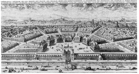
Plate 1.
The Porte and Place Porte de France. An engraving of 1640 taken
from a 1615 design for the Place de France, a synecdoche for France. Henri
IV planned the Place for the area near the northern city wall, but it was never
built. Each of the twenty-four approaching and connecting streets was to bear
the name of a province, the significance of the province determining the size
and centrality of the street. The eight main streets leading into the place
represented the largest provinces; the seven concentric connecting streets
took the names of the lesser provinces; and the smallest interconnecting
streets were allotted to the smallest provinces. No wonder a later commentator
called it "the most national, the most French idea that any French sovereign
had ever conceived . . . a sort of national Pantheon." (Photograph courtesy
of the Bibliothèque Nationale, Paris.)
rounding the new Théâtre de l'Odéon in 1779 should bear the names of illustrious French dramatists. But as he foretold the brouhaha, Mercier confidently insisted that the scandal would not last. City officials, he conjectured, would soon get used to seeing Corneille and Molière as the "companions of their glory."[7]
The royal practice of urban nomination found its clearest expression not in any site or name that we can recall today but in Henri IV's extraordinarily ambitious project for the Porte and Place de France. In this vast semicircular place to be located immediately inside the northern city wall, each of twenty-four approaching and connecting streets was to bear the name of a province. The size of the street correlated with the geopolitical importance of the province: the eight main streets leading into the center of the place bore the names of the greater provinces (Picardie, Dauphiné, Provence, Languedoc,
Guienne, Poitou, Bretagne, Bourgogne); the seven concentric connecting streets stood for the lesser provinces (Brie, Bourbonnais, Lyonnais, Beauce, Auvergne, Limousin, Périgord); and finally, the smallest interconnecting streets signified the smallest provinces (Saintonge, La Marche, Touraine, Le Perche, Angoulême, Berri, Orléans, Beaujolais, Anjou).
Perhaps the Place de France represented royal hegemony too perfectly; or perhaps its conception of toponymical relations was too abstract for the early seventeenth century. In the event, Henri IV was assassinated before he could proceed, and his successors let the venture drop. The plan was not even printed for another thirty years. But it is a remarkable document, striking for the modernity of its conception; for the Place de France, in effect, reduced to a single text the political program that concerned all of the regimes over the nineteenth century. It was, to take the exalted terms of a nineteenthcentury commentator all but overcome with patriotic fervor, "the most national, the most French idea that any French sovereign had ever conceived." Had it been realized, this observer enthused, France would have had "a sort of national Panthéon" before the fact, a monument to "strike the imagination" and propagate edifying "moral and political ideas" among the populace.[8]
Whether these pedagogical considerations were those of the first Bourbon monarch or, more likely, those of a nineteenth century fairly obsessed with creating national unity, the moral and political idea that drove this experiment was indubitably the integration of France and its capital. The Place de France made synecdoche visible, since it, like the honorific model of nomination more generally, tied the street to ideology. As a consequence, the Place broke the link of street to site and severed the connection between toponymy and local urban practices and personages. The Revolution changed the ideology, but the first rebaptism of a Paris street in 1791 followed the principle of symbolic control established by the monarchy over a century and a half before.
In turning into an act of state, the naming of streets reverted to the adamic model. Nomination presupposed creation. Presumably, usage followed. But how do city dwellers know their streets other than through usage? Registration of street names entered them into the public record, but those early records were unlikely to affect many users directly. Moreover, the scarcity of reliable maps and their lack
of portability complicated inordinately any venture out of one's immediate vicinity. The Swiss visitor to Paris in 1663 who took three hours to reach his destination was neither the first nor the last to find himself in such a predicament. The colorful, striking store signs helped only after one reached the right street.
Hence, the single most important measure for the integration of the street and the neighborhood into the city, and the first step toward rationalizing use of the urban text, was the decree that the name be fixed on the street itself. The first real street sign dates from 1643, when the Dominicans requested permission to mark the street on which their convent was located "Rue Saint Dominique formerly Cow Street." Surprisingly perhaps, not until 1728 did the lieutenant général de la police order names placed on the first and last house of every street in Paris. The often vehement resistance to the decree revealed the still very weak sense of the city as a whole to which individuals subordinated their personal affairs. To foil the recalcitrant owners who tore off the metal plaques nailed onto their houses, an ordinance in 1729 directed that the name of the street and the number of the quartier be chiseled in a stone set into the wall itself. Many of these inscriptions can be seen still today, some with the same name as on the contemporary sign, others with names that invoke the older city. In 1823 metal plaques with white letters on a black background replaced the names in stone, and beginning in 1844, enamel plaques with white letters on a blue background replaced the first plaques. The current signs in Paris are flimsy metal imitations of these blue and white enamel plaques.
The formal street sign dealt the final blow to popular nomenclature. Although registration tended to sanction usage, in the long term it was inscription that decided usage. The written language fixed the urban text, quite literally writing that text. The evident disdain for and fear of popular culture come to the fore in the "sanitizing" of some of :he earthier appellations. The Dominicans did away with the cows that had once pastured in the area, and some two hundred years later Voltaire campaigned (to no avail) to replace cul-de-sac with impasse. Tire-vit (Pull-Prick) had already been euphemized to Tireboudin (Pull-Sausage) by the fourteenth century, but some found even that unseemly. Obscene names were, first of all, unworthy of a civilized society. From his position as a spokesman of the Age of Enlightenment, Mercier peremptorily declared that the obscene names of the older streets "attest to the turpitude of our ancestors." On the
other hand, with his characteristically titillating rhetorical flourish, Mercier held out little hope to change the ways of people who gave "obscene forms" to the pastries they baked![9]
The Revolution made the divide between past and present even more absolute, for the old regime was not simply the past, it was a past that had been repudiated. The sense that a new society required a new toponymy is especially acute in a guide to Paris published in 1801 by one J. B. Pujoulx, man-about-town and all-purpose man of letters. More anxious than Mercier to break with the inappropriate past and more aware of the larger mission of Paris in the world beyond France, Pujoulx worried that from the "obscene names that dirty the corners of certain streets" visitors would infer the immorality of the present inhabitants.[10] Naturally, Pujoulx roundly condemned Tire-Boudin, although he had to admit that it was a decided improvement over the previous name, which he declined to specify. (Tire-Boudin soon became the rue Marie Stuart.) Thus modernizing Paris went about the task of civilization, of making itself into the image of the new world fit for the new century. As Norbert Elias argues in The History of Manners, such measures demonstrate that the march of "civilization" compelled dissociation from the (inferior) past and eradication of practices that did not measure up to the standards of the present. The present day was clearly superior in the eyes of contemporaries, and every precaution had to be taken to make that superiority evident to all.[11]
Pujoulx, good son of the Enlightenment that he was, deplored the "incoherence" and "bizarreness" of Paris street names as a whole even more than he did the indecency of one or another street. They were a "ridiculous assortment," a "salmagundi," and the present name was almost always at odds with the present situation or destination of the street. To straighten out the streets by providing "reasonable" names, Pujoulx endorsed turning all of Paris into a geography lesson. All the streets would bear the names of major towns and cities in France. The size of the street would correspond to the size of the city, with the longer streets running through several quartiers reserved for the major rivers. Through its street names, Paris would be France, and topography would once again signify as it had in the medieval, descriptive names.
The difference was crucial. Henceforth, the city would signify not as nature but as ideology. Two centuries after the fact, Pujoulx extended to the entire city the rationale of Henri IV's Place de France
(to which Pujoulx seems to refer, if rather elliptically), transforming the streets of Paris into the map of France. The eighteenth century transformed this preoccupation with coherence into a system for the entire city. Pujoulx's proposal of 1801 stands as a clear demonstration of the strength of these convictions and the force of this vision of the city as an integrated, intelligible whole, as a distinctive testimony to the forward march of civilization.
Pujoulx, apparently unwittingly, reiterated a project a half century old. The Géographie parisienne elaborated by the abbé Teisserenc in 1754 had elevated the principle of Henri IV's Place de France into a system to. comprehend all of Paris and all of France. (The enthusiastic abbé went so far as to suggest that the system could be carried to every state in the whole world!) The typically prolix eighteenth-century subtitle told it all (or almost): En forme de dictionnaire, contenant l'explication de Paris ou de son plan mis en carte géographique du royaume de France, pour servir d'introduction à la géographie générale; méthode facile et nouvelle pour apprendre d'une manière pratique et locale toutes les principales parties du royaume ensemble et les unes par les autres. (Dictionary, Containing the Explanation of Paris or Its Map Turned into a Geographical Map of the Kingdom of France, to Serve as Introduction to General Geography; An Easy and New Method to Learn in a Practical Manner and on the Spot All the Principal Parts of the Kingdom as a Whole and Each Through the Others ) Because he recognized that names are "arbitrary signs" and easily altered, the abbé Teisserenc held strongly for a system that best suited the public good. Pujoulx admitted that an acquaintance had made the connection between his plan and another "about like it," but disavowed any knowledge of such a project. Still, he readily conceded that the basic idea was so elementary that it might have occurred to a good many others. He was, in any case, less interested in being first than in being the one to bring a rational system of nomination to public notice. Perhaps his plan would work.
The key word is system. Rationalization showed up on the obverse of the coin of royal appropriation of the city. Not just a few streets or a square, however splendid, but the entire city was intended to signify within a larger urban strategy. All Paris was to serve a larger, nobler purpose. The jumble of street names made all too obvious the inevitable discrepancy between the actual city and the city as project, between the real and the ideal. The utopian nature of these nominatory projects became clearer in the plans drawn up for new cities. The grid
on which so many new cities were laid out in Europe as well as in America from the seventeenth through the nineteenth centuries was the very emblem of a rationalized topography modeled against the norm. But with their roots in the densely populated and overbuilt central sections and intricate network of medieval streets, the older cities thwarted every attempt at rational planning. Even in the early seventeenth century, the Place Royale and the Place Dauphine had to be constructed on vacant land distant from central Paris. The work of centuries and of many hands, these old cities were irrational in the extreme. The poorly designed layout, the odd proportions, and the crooked, uneven streets prompted Descartes' observation that these old central cities looked more like the work of chance than reason.[12]
A comprehensive name scheme provided a signal means by which to negate, or at the very least camouflage, topographical irregularity. It suggested the unification of the city around a grand design, which would turn it into a product of reason rather than chance. This newly coherent city would achieve human mastery of nature and society. The ideal city would be rational, and it would be ideologically coherent. The Revolution offered an unprecedented opportunity to do just this, to redesignate, and thereby, to redesign the city.