
Boundaries and Settlement Pattern
A discussion of communal boundaries in rural England begins inevitably with the parish, the primary unit of ecclesiastical administration, which set the parameters of social organization at least from the early modern period. Following the Webbs, the parish can be defined in simplest terms as "a 'shrift-shire', the sphere of reciprocal duties between a duly commissioned priest and the inhabitants in his charge."[5] Parishes, consequently, centered on their churches, although the territory they encompassed often varied considerably, as did the size of their respective populations.
Smaller parishes usually possessed nucleated settlements and for this reason were better served by their incumbents. Their churches were located accessibly at the center of the parish, which made
gaining a foothold difficult for Dissenters.[6] In larger parishes, settlement patterns tended to be irregular; chapelries might, therefore, be created in their more remote districts in order to give the inhabitants some contact with established religion.[7] Chapelries did not, however, enjoy the same status as churches; they were not supported from their own tithes, nor always consecrated,[8] a condition that made them less appealing alternatives to Dissenters' chapels. Still, Anglican authorities did not always create chapelries in outlying parochial districts, leaving them wide open to competition from Dissenters. These same districts, moreover, sometimes spawned boundary settlements.
A boundary settlement developed at the borders of two or more parishes, with its various neighborhoods emerging under competing parochial jurisdictions. The Vale occupied just such a position prior to its creation as a civil parish in 1892. The boundaries of Horsley, Avening, and Minchinhampton crossed Nailsworth village, its surrounding hamlets likewise distributing themselves among these three parishes. Shortwood and Newmarket were in Horsley; Forest Green, Inchbrook, and Winsoredge were in Avening; and Watledge, including Scar Hill, was in Minchinhampton.[9] Village and hamlets together constituted the community of the Vale, although it was possible to distinguish even smaller valleys lying between them[10] (see map 1).
Nailsworth's peculiar treatment in land tax returns and extant manor records, as well as its contradictory classification in the early censuses,[11] reflected the confusion regarding its proper boundaries. The land tax returns describe Nailsworth as a tithing of Avening; as an outlying district on that parish's western border, the assessor allocated it a separate listing of owners and occupiers, indicating a semiautonomous status.[12] Nailsworth's connection with Avening arose from the annexation of the manor of Nails-worth to the manors of Avening and Minchinhampton in the sixteenth century. The manor of Nailsworth had existed as early as the reign of Henry II and extended from Aston Farm to Winsoredge.[13] The records of Horsley manor also refer to a tithing of Nailsworth, which ought to have included only that portion of the village already under the jurisdiction of Horsley parish.[14] Nevertheless, the boundary of this tithing extended into Averting proper, as far as Winsoredge, in what was clearly disputed terri-
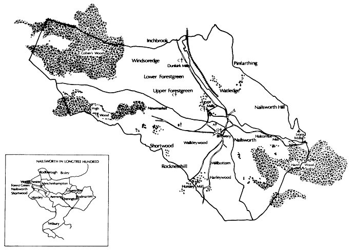
Map 1.
Boundary map of Nailsworth, with inset: Nailsworth in Longtree Hundred. Scale: six inches = one mile. Source:
Boundary Survey Map, 1892. Inset: The Victoria County History of Gloucestershire, Vol. XI.
tory: Nathaniel Wilkins, a broadweaver of Horsley, had been granted a ninety-nine year lease in 1692 on "all that one close of pasture ground lying . . . near to a place called Winsorhedge [sic ] within the parish of Horsley [!] aforesaid."[15]
Such peculiarities were in part the result of the gradual expansion of the Vale's original settlement, which depended on the development of its economy. The growth of the cloth trade and population increase tended to form its dispersed hamlets into a more unified entity, although they never entirely lost their individual autonomy. Naturally, the original settlement antedated the arrival of Dissenters and was considerably influenced by the landscape.
The most fundamental distinction regarding the English rural landscape is that between the Champion regions, or predominantly arable societies, and the forest or wood-pasture regions that emphasized stock rearing.[16] These economic activities were not mutually exclusive, the distinction between them depending on degrees of specialization. The Cotswold region of Gloucestershire was a wood-pasture society in which sheep rearing was important, although the proportion of land under tillage was higher there than in the Vales of Berkeley and Gloucester, which concentrated on dairying, fruit growing, and market gardening.[17] Champion regions were associated with nucleated settlements, small parishes, and a low incidence of Dissent. The poorer soils of wood-pasture areas, in contrast, encouraged the growth of industrial by-employments, while hilly terrain created irregular settlements in which Dissent more easily proliferated. How well Nailsworth conformed to the criteria of a wood-pasture society can be seen from its economic geography (see fig. 1).[18]
The etymology of Nailsworth evokes a very early association with the wool trade. The Anglo-Saxon "Nael" is a derivative of the teutonic "nagel," which is a measure of seven pounds in
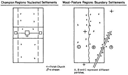
Fig. 1.
Champion and wood-pasture settlements.
weight for wool; the stem, "worth," is derived from the Anglo-Saxon "weorth," meaning market or enclosure.[19] "Nailsworth," therefore, means "wool market," although this very likely reflected a later characterization. The earliest reference to Nails-worth appears as early as 716 in a charter of King Ethelbald in which "Negelsleag Minor" is mentioned.[20] The stem "leag" refers to a pasture or wood and seems to indicate that part of a forest was cleared and the land used as sheep pasturage. Thus the region was initially associated with the wool trade chiefly as a supplier of raw material. With the settlement of the village as a market center, "leag" must have been altered to "weorth." This change undoubtedly coincided with the establishment of fulling mills in the area, as the transition was made to a more active engagement in production. Fulling mills were present at Nailsworth during the reign of Henry II,[21] and by the end of the thirteenth century the Vale and the rest of the Stroud region had emerged as important centers for the manufacture of woolen cloth.[22]
Early rural manufacturing, from the medieval period, was based on cottage industry. Clothiers from Nailsworth village distributed raw wool to the spinners and the spun threads to the weavers; they collected the woven pieces, had them finished, and then marketed
the final product. Marketing took place initially at Nailsworth village; later at county fairs held at Stroud, the nearest market town; and, as time progressed further, with agents of the London cloth factors.[23]
Unburdened by urban guild restrictions, clothiers had at first engaged cottagers on the basis of secondary, industrial by-employment,[24] a development associated with settlements on wastes, commons, and woodlands. Weavers, clothworkers, laborers, and artisans established settlements by building cottages on wasteland, or in a forest clearing, and fencing off a patch of ground to be tilled as a garden or a small farm. John Chambers of Nailsworth, cordwainer, was formally accused in Horsley's manor court of erecting "a cottage and encroaching eight lug of the waste on Rockness Hill." Samuel Manning, weaver, encroached ten yards of waste and built a cottage at Wash Pond; and Abraham Kitteral, with twenty others, was charged with "tak[ing] away the turf on the waste lands."[25] More prosperous artisans and laborers occupied lands either in the common arable fields, where these survived from medieval times, or in enclosed patches that they either leased or purchased outright. John Pavey, a clothworker from Avening, bequeathed to his wife Mary "a tyning of arable"; to five grandchildren he bequeathed in trust "all messuages, lands and woods which I bought and purchased of my son-in-law, John Penley"; and to his eldest grandson he bequeathed two acres of wood and woodland ground "which I lately bought and purchased to myself . . . situate at Winsoredge."[26]
This practice of dual occupations persisted into the 1850s: "The existence of manufactures in the midst of an agricultural district," one observer commented in 1854, "made the inhabitants not as entirely dependent on either calling."[27] He undoubtedly exaggerated. In the medieval period, spinning and weaving may have been undertaken as activities ancillary to agriculture. By 1841 the reverse was true; a division of labor, created first by protoindustrialization and later intensified by the factory system, made woolworkers dependent on manufacturing, however much they engaged in argicultural by-employment.
The industrial character of the region, as it had matured from the seventeenth century, can be illustrated from the 1841 census. Tables 1 to 3 give the occupational distributions for Nailsworth
TABLE 1. | ||||||||||||||||||
Nailsworth Villagea | Shortwood | Newmarket | Forest Green | Winsoredge | Watledge | |||||||||||||
% | % | % | % | % | % | % | % | % | % | % | % | |||||||
N | Pop . | Emp . | N | Pop . | Emp . | N | Pop . | Emp . | N | Pop . | Emp . | N | Pop . | Emp . | N | Pop . | Emp . | |
Retailersb | 20 | 1.5 | 4.2 | 8 | 2.4 | 8.2 | 5 | 1.5 | 3.1 | 2 | 0.6 | 2.0 | 7 | 2.1 | 6.1 | 8 | 1.7 | 7.6 |
Artisans | 87 | 6.8 | 18.1 | 11 | 3.3 | 11.2 | 23 | 6.8 | 14.5 | 16 | 5.0 | 15.7 | 12 | 3.6 | 10.4 | 23 | 4.8 | 21.9 |
Weavers | 43 | 3.4 | 9.0 | 21 | 6.3 | 21.4 | 34 | 10.1 | 21.4 | 30 | 9.3 | 29.4 | 24 | 7.2 | 20.9 | 10 | 2.1 | 9.5 |
Spinners | 1 | 0.07 | 0.2 | — | — | — | — | — | — | — | — | — | — | — | — | — | — | — |
Cloth- | 57 | 4.5 | 11.9 | 17 | 5.1 | 17.4 | 34 | 10.1 | 21.4 | 36 | 11.2 | 35.3 | 36 | 10.8 | 31.3 | 84 | 17.4 | 80.0 |
Subtotal | 101 | 7.9 | 21.1 | 38 | 11.3 | 38.8 | 68 | 20.2 | 42.8 | 66 | 20.6 | 64.7 | 60 | 18.0 | 52.2 | 95 | 19.6 | 90.5 |
Agricultural- | 45 | 3.5 | 9.4 | 13 | 3.9 | 13.3 | 3 | 0.9 | 1.9 | 21 | 6.5 | 20.6 | 17 | 5.1 | 14.8 | 11 | 2.3 | 10.5 |
Laborers | 18 | 1.4 | 3.8 | 4 | 1.2 | 4.1 | 22 | 6.5 | 13.8 | — | — | — | — | — | — | — | — | — |
Farmers | 9 | 0.7 | 1.9 | 2 | 0.6 | 2.0 | 1 | 0.3 | 0.6 | 2 | 0.6 | 0.3 | 2 | 0.6 | 1.7 | 1 | 0.2 | 0.95 |
Total pop. | 1,273 | 335 | 337 | 321 | 334 | 484 | ||||||||||||
Total emp.c | 480 | 98 | 159 | 102 | 115 | 105 | ||||||||||||
a Nailsworth Village here includes parts of Box and West End districts. | ||||||||||||||||||
b 'The occupations here represent all of those in the district, not merely the ones of household heads as in the comparison with the 1811 enumerator's listing. | ||||||||||||||||||
c "Emp." refers to the number employed, that is, with stated occupations. | ||||||||||||||||||
Source : Census Enumerator's Lists, 1841: Home Office 107/362. | ||||||||||||||||||
TABLE 2. | |||||||||
Theescombe | Barton End | Rockness | |||||||
% | % | % | % | % | % | ||||
N | Pop . | Emp . | N | Pop . | Emp . | N | Pop . | Emp . | |
Retailers | 5 | 1.2 | 4.0 | 1 | 0.4 | 0.9 | 3 | 1.1 | 2.9 |
Artisans | 13 | 3.0 | 10.4 | 7 | 2.6 | 6.4 | 16 | 5.8 | 14.7 |
Weavers | — | — | — | 11 | 4.1 | 10.0 | 10 | 3.7 | 9.8 |
Spinners | 1 | 0.2 | 0.8 | 4 | 1.5 | 3.6 | 1 | 0.4 | 0.98 |
Clothworkers | 47 | 10.8 | 37.9 | 23 | 8.6 | 20.9 | 38 | 14.0 | 37.3 |
— | —— | —— | — | —— | —— | — | —— | —— | |
Subtotal | 48 | 11.0 | 38.7 | 38 | 14.8 | 34.6 | 49 | 18.0 | 48.0 |
Agricultural- | 1 | 0.2 | 0.8 | 38 | 14.8 | 34.6 | 18 | 6.6 | 17.7 |
Laborers | 5 | 1.2 | 4.0 | 1 | 0.4 | 0.9 | 1 | 0.4 | 0.98 |
Farmers | 4 | 0.9 | 3.2 | 4 | 1.5 | 3.6 | 1 | 0.4 | 0.98 |
Total pop. | 436 | 268 | 272 | ||||||
Total emp. | 124 | 110 | 102 | ||||||
Source : Census Enumerator's Lists, 1841: Home Office 107/362. | |||||||||
and its neighboring villages; table 4 and figure z interpret them by comparing three zones. Zone I (in fig. 3) represents Nailsworth village and its dispersed hamlets. Zone II is an inner periphery consisting of those districts that border the Vale: Theescombe, in Minchinhampton and Barton End and Rockness in Horsley. Zone III, an outer periphery of sample villages at a distance from the Vale, included Horsley and Avening villages as well as Box, Burleigh, and Littleworth villages in Minchinhampton.
Examining the Vale first, it can be seen that the number of wool-workers, as a proportion of the total workforce, was much higher in Nailsworth's surrounding hamlets than in the village itself. At Nailsworth they accounted for only 9.5 percent of the workforce, while in the surrounding hamlets they accounted for 56.0 percent. Nevertheless, woolworkers constituted the largest occupational group resident at the village. This anomaly may be explained by the fact that Nailsworth had acquired a quasi-urban, cosmopoli-
TABLE 3. | |||||||||||||||
Box | Burleigh | Horsley | Avening | Littleworth | |||||||||||
% | % | % | % | % | % | % | % | % | % | ||||||
N | Pop . | Emp . | N | Pop . | Emp . | N | Pop . | Emp . | N | Pop . | Emp . | N | Pop . | Emp . | |
Retailers | 14 | 3.2 | 5.6 | 20 | 4.0 | 10.5 | 9 | 2.0 | 5.1 | 6 | 1.2 | 3.8 | 12 | 1.9 | 7.1 |
Artisans | 28 | 6.4 | 11.2 | 31 | 6.3 | 16.2 | 24 | 5.5 | 13.6 | 40 | 7.8 | 25.0 | 24 | 3.8 | 14.1 |
Weavers | 63 | 14.5 | 25.1 | 14 | 2.8 | 7.3 | 18 | 4.1 | 10.2 | 3 | 0.6 | 1.9 | 38 | 6.0 | 22.4 |
Spinners | 4 | 0.9 | 1.6 | 1 | 0.2 | 0.5 | 12 | 2.7 | 6.8 | 3 | 0.6 | 1.9 | — | — | — |
Clothworkers | 121 | 27.8 | 48.2 | 66 | 13.4 | 34.6 | 22 | 5.0 | 12.4 | 25 | 4.8 | 15.6 | 41 | 6.5 | 24.1 |
Subtotal | 188 | 43.1 | 74.9 | 81 | 16.4 | 42.4 | 52 | 11.8 | 29.4 | 31 | 6.0 | 19.4 | 79 | 12.5 | 46.5 |
Agricultural | — | — | — | 1 | 0.2 | 0.5 | 59 | 13.4 | 33.3 | 48 | 9.3 | 30.0 | — | — | — |
Laborers | 31 | 7.1 | 12.4 | 29 | 5.9 | 15.2 | 2 | 0.5 | 1.2 | 6 | 1.2 | 3.8 | 27 | 4.3 | 15.9 |
Farmers | 3 | 0.6 | 1.2 | — | — | — | — | — | — | 1 | 0.2 | 0.6 | 3 | 0.5 | 1.8 |
Total pop. | 436 | 494 | 440 | 516 | 634 | ||||||||||
Total emp.a | 251 | 191 | 177 | 160 | 170 | ||||||||||
a "Emp." refers to the number employed, that is, with stated occupations. | |||||||||||||||
Source : Census Enumerator's Lists, 1841: Home Office 107/362. | |||||||||||||||
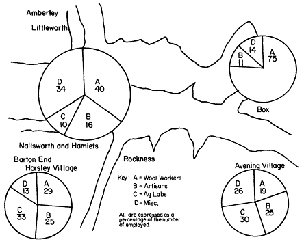
Fig. 2.
Selected occupations in Nailsworth and surrounding villages, ca. 1841.
tan status, containing a very high proportion of artisans and retailers and even miscellaneous occupations such as "police officers." As early as 1806 an advertisement for the sale of merchant property described Nailsworth as "a very populous and flourishing village." Another advertisement, for the sale of a millinery shop, had described Nailsworth proper as "genteel and populous," and a third, for the letting of a baker's shop, referred to the property's location as "the preferable part of Nailsworth."[28] Clearly, the village had acquired the social distinctions characteristic of a small town.
Toward the outer periphery in the directions of Horsley and Avening villages, the proportion of resident woolworkers fell significantly, while that of agricultural laborers rose. The reverse was true of the Minchinhampton villages; their clothworking popula-
TABLE 4. | ||||
Occupations a | Vale | Inner periphery | Avening- | Box-Bur- |
Woolworkers | 0.56 | 0.40 | 0.25 | 0.57 |
Agricultural | 0.112 | 0.169 | 0.317 | 0.001 |
a In difference-of-proportions tests between the Vale hamlets and the inner periphery, for woolworkers, Z = 4.675, significant at the 0.0 level; and for agricultural laborers, Z = 2.448, significant at 0.007. | ||||
Source : See text. | ||||
tions proportionately equaled those of the Vale's hamlets, and they contained even fewer agricultural laborers.
The inner periphery consisted of dispersed hamlets situated between more heavily concentrated areas. Theescombe division, in Minchinhampton, lay between Amberley and Nailsworth village just north of the Vale. Rockness district, in Horsley, bordered Avening parish to the east and was virtually part of the Vale's settlement. Barton End district, located to the south of Nails-worth, extended to the outskirts of Horsley village. Table 4 presents the differences between the three zones in their respective proportions of woolworkers and agricultural workers. Figure 2 offers a more schematic summary of the occupational differences between the Vale, Horsley and Avening villages and Box village, which lay at the outskirts of the town of Minchinhampton. Horsley and Avening parishes, exclusive of the Vale community, were clearly more agricultural, and Minchinhampton emerges as almost completely industrialized.[29]
Apart from the clothworking population, the industrial villages included a variety of artisans, such as carpenters, blacksmiths, and masons, as well as retailers ranging from bakers to publicans and vintners. Middle-class occupations included farmers, clothiers, pinmakers, maltsters, and brewers. The landed gentry, naturally, were situated at the top of the social hierarchy.
"Gentlemen" were not included as an occupational category in the 1841 census but were listed as such in an 1811 manuscript
census for Horsley parish.[30] Horsley's resident gentlemen numbered twelve in 1811, representing 2.5 percent of all householders with occupations. They included one "gentlewoman," a Sarah Harvey, the recent widow of John Harvey of Drawley Estate,[31] and the head of a household of five females. The eclipse of the title "gentleman" reflected the dilution of its meaning under the pressure of upward social mobility. At the other end of the social spectrum, woolworkers came to represent a more homogeneous class as a result of the emergence of the factory system.[32]