The Landscape
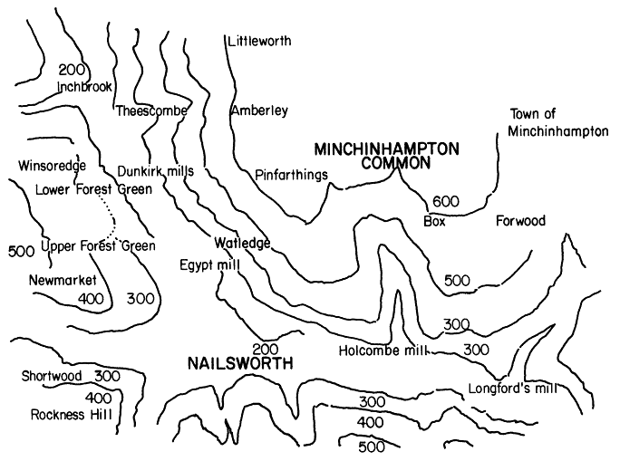
The Stroud district is located at the midpoint of the Cotswold hills, which occupy the eastern part of Gloucestershire. At their highest point, they reach an elevation of 1,093 feet at Cleeve Hill, and the average height of twelve of the highest peaks is 834 feet above sea level. Elevations near Stroud are lower, ranging from 200 to 600 feet.[64] Nonetheless, such extremes in elevation occurring within short distances transmitted an aura of remoteness to localities such as Nailsworth, as well as a sensation of social complexity (see map 2).
Approaching the Vale from the southwest, and moving northeasterly, the traveler, while on walking tour, encounters Horsley village on its immediate periphery at an elevation of 500 feet. Continuing in a northeasterly direction, the hamlets of Newmarket, Forest Green, Winsoredge, and Inchbrook emerge, varying in elevation from 300 feet at Newmarket to 400 feet at Forest Green and dropping to zoo feet at Winsoredge and Inchbrook.[65] Turning
Map 2.
Elevations of hills at Nailsworth. Source: Ordinance Survey Map, with elevations (1885).
southeasterly, while moving along the bottom of the valley, the traveler passes Dunkirk and Egypt mills until reaching Nailsworth village. The Nailsworth valley continues in a southeasterly direction as the traveler passes Holcombe and Iron mills, finally reaching Longfords mill. Thereafter, the ascent begins once more, rising to 500 feet at Avening village on the southeasterly periphery of the Vale.
Beginning the ascent from Nailsworth village, however, and moving in a northeasterly direction, the traveler encounters the hamlets of Watledge and Nailsworth Hill, which rise, respectively, to levels of 400 and 500 feet. They constitute the Vale's outer limits as one moves toward the southernmost edge of Minchinhampton Common. Continuing northeasterly along the edge of the Common, the traveler passes Box and Forwood villages before finally arriving at the old wool town of Minchinhampton. The town and the villages that ring the Common (suggesting its importance to their original pattern of settlement) stand at 600 feet above sea level, the highest point in the neighborhood, overlooking the broad valley of the river Severn to the north. From these heights originate the streams and rivulets that fertilize the valleys below.
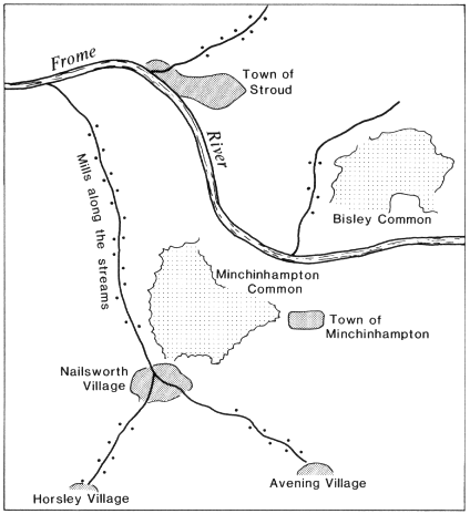
Each valley of the Stroud district is associated with a comb or "bottom"; and each comb, with a spring or rivulet that emerges from the strata of Lias Clay and Supra-Liassic or Cotswold Sand. The drainage of the area follows the slopes of the hills, and the valleys give a westerly direction to the flow. The Stroud district is drained by the river Frome, which empties into the Severn. At the town of Stroud, the springs flowing down from the north are joined by the Slad and Painswick brooks, and at Dudbridge by those of Ruscombe and Nailsworth, which flow in from the south.[66] The Nailsworth stream is formed by the junction of two rivulets that rise, respectively, near Avening and at Horsley and contains the drainage of the Vales of Nailsworth and Woodchester[67] (see map 3).
Map 3.
The Frome River valley and streams. Source: 1-inch Ordinance Survey
Map, ca. 1885, Gloucester Records Office Q/RUM 304.
These streams, together with the water-bearing soils that allowed them to flourish, crucially determined the settlement of the Vale. "These villages," William Cobbet remarked in 1830, "lie on the sides of a narrow and deep valley, with a narrow stream of water running down the middle of Jr." Nor could he fail to observe how "this stream turns the wheels of a great many mills and sets of machinery for the making of woolen cloth."[68]
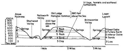
Fig. 3.
Section of the hills near Nailsworth, Gloucestershire. Source:
In the possession of David Playne, Bannut Tree, Avening,
Stroud, Gloucestershire, Playne Family Papers.
The regularity of the supply of water and the actual power the streams generated were mutally dependent on the quality of the soil and the distances the flow of water needed to travel from hill to vale. The formation of Upper Lias Clay and Supra-Liassic or Cotswold Sand, because of their porous and fraible natures, acted "as . . . spung[es], into which all the water that percolated through the beds [from above] is received and stored."[69] Notwithstanding variations in the rate of drainage, a reasonably good supply of water was usually obtainable year-round.[70] The positions of the clays and sands, furthermore, were always marked by the lines of cottages that dotted the slopes of the hills: "Everywhere [the villages and hamlets] are all built near the base of the sands and just above the line where the water is thrown out by the Upper Lias."[71]
Apart from the clays and sands, which were crucial to the establishment of cloth mills, numerous quarries of both the Inferior and Great Oolites were developed at Scar Hill, near Nailsworth, and around Minchinhampton Common. They provided much of the building material that has added another distinctive feature to the landscape (see fig. 3).
The Fuller's Earth, which normally lies between these two formations, is largely responsible for the fertility of the slopes. In the Vale of Nailsworth, especially, the hills tend to be capped by the Great Oolite; the slopes of Inferior Oolite are thereby covered with slipped Fuller's earth, which "has upon its surface a rich
TABLE 8. | ||||
Parish | Total acreage | Percent arable 1800-1804 | Percent arable 1838-1841 | Percentage change |
Horsley | 4,145.0 | 33.3 | 47.6 | 42.7 |
Avening | 4,512.5 | 34.0 | 63.8 | 87.4 |
Minchinhampton | 4,942 | 48.8 | 43.6 | -10.5 |
Source : See text. | ||||
TABLE 9. | |||||||
Parish | Total arable land | Wheat | Barley | Oats | Peas | Beans | Turnips |
Horsley | 1,382.5 | 734 | 190 | 300 | 43 | 9.5 | 106 |
Avening | 1,536 | 481 | 278 | 638 | 32 | 31 | 66 |
Source : See text. | |||||||
soil well adapted for cultivation."[72] In Horsley, Avening, and Minchinhampton—the parochial hinterland of the Vale—wheat, barley, and oats were the principal crops grown, while peas, beans, and turnips were secondary. Tables 8 and 9 indicate, respectively, the percentages of parish lands under tillage in 1800 and 1840 and the amount of acreage devoted to each type of crop around 1800. The increase in arable land under cultivation at Avening was caused by the shrinkage of the wasteland and at Horsley, very likely, by more intensive husbandry resulting from greater concentration of ownership; the fall in cultivated arable land at Minchinhampton was due to that parish's more complete industrialization.[73]
Actual crop yields, however, are difficult to ascertain. Of the three parishes, only the tithe survey for Avening gives any indica-
TABLE 10. | ||||
Crop | Estimated arable acres sown | Bushels | Bushels as % total yield | Bushels per acre estimated arable land |
Wheat | 904.9 | 7,416 | 18.8 | 8.2 |
Barley | 522.9 | 13,153.4 | 33.3 | 25.2 |
Oats | 1,200.3 | 18,933.3 | 47.9 | 15.8 |
Source : See text. | ||||
tion. However, since each parish contained the same type of soil, one can assume that Avening's crop yield was typical of that of its region. If the tithe charge were one-tenth of the yield (as the name of this tax suggests), the total yield could be estimated;[74] this estimate is depicted in table 10. Wheat was marketed for human consumption and oats for animals, while the very high barley yield reflected the strong demand from the malting and brewing industry.[75] The low wheat yield and the significantly higher yields for oats and barley affirm that the region, as a wood-pasture society, was better adapted to stock rearing and industrial activities, some of which remained ancillary to agriculture.[76]
A wood-pasture society, Nailsworth once was covered by dense forests, which were only partially cleared as settlements became established. Local place names such as Shortwood, Harleywood, and Collier's Wood testify to their importance, as occasionally do the field names. A parcel of arable land, occupied by a tenant of Robert Kingscote and consisting of 17 acres, was called "Horsley Wood field" in Horsley's 1841 tithe survey. Clearly, it had once been part of a common arable field, which served as woodland ground in an earlier period. The same could be said of three acres of arable land near Nailsworth called "Woodleaze," which was put up for sale in 1823. At Newmarket in this same year a half acre, sold by auction and "covered with a plantation of thriving timber trees of different kinds," revealed the extent to which the region remained forested even at this late date.[77]
Field names, moreover, evoked the image of a once quite isolated district. "Hither Robbers Green," "Middle Robbers Green,"
and "Far Robbers Green" suggest the uses to which a forest region, combined with an uncertain parochial jurisdiction, might have once been put by shrewd evaders of the law,[78] at least until the advent of a better communications system. "Until then," commented one local historian, "we can see what rough and steep perilous routes [the roads] must have been for the traveller, and not lightly to be followed."[79]
By 1825 the Vale had become fully integrated into its surrounding region; increased geographic mobility, facilitated by improved communications, rendered Nailsworth a far less isolated locale. The growth of communications, while promoting the regionalization of local society, also contributed to the process of industrialization. Turnpikes, canals, and railway lines constituted a new infrastructure, on the basis of which the woolen industry expanded. Despite the advent of the factory system the woolen industry failed, however, reflecting the slow development and incompleteness of this very infrastructure. As a result, the network of improved communications, although promoting regionalization, altered the landscape only to a limited degree.