THE SOUTH SEA WAGGONER
Shewing the making & bearing of all the Coasts from California to the Streights of Le Maire done
Basil Ringrose
Image not available.
Symbols Used by Ringrose on Waggoner Charts
 | Anchorages |
Soundings are in fathoms on the few charts that show them.
Conventions Used in Footnotes
* | An alteration by "Black" (see p. 42) |
Hack f. 12 | Folio numbers in the Greenwich copy of Hack's South Sea Waggoner (W8 ) |
Cavo de Andreus is the utmost cape the Spaniards make use of in there Voyages to the East Indies.[1] The Discription of the Coaste of this Island is as followeth declared at large.[2]
[1] For a recent discussion of the Manila galleon trade with map, see Bruman 1981.
[2] For the history of California as an island, see Tooley 1963, and Leighly 1972.
Image not available.
Chart 2
Anian —a legendary strait connecting the Pacific with the Polar Sea. The name derives
from 'Aniu' in the account of Marco Polo's travels. As a strait, the name is first found in a
pamphlet by Giacomo Gastaldi, who used the name 'Ania' in 1559. Its first appearance on
a dated map was on Bologna Zaltieri's map of Nova Franza in 1566, as 'Streto de Anian,'
probably copied from a lost map of Gastaldi (W. Michael Mathes, private communication; and
Wagner 1968, 426).
Quivera o Nueba Granada —Quivira, a legendary kingdom sought by explorers and placed
on maps anywhere from Kansas to California. Granada is an important city in old Spain
and also a city on Lago de Nicaragua in Central America. Nueva Granada was also
the name applied to Colombia in colonial times.
Nueba Ginea
Cavo Coriantes = Cabo Corrientes ('corriente' = current).
Acapulco = Acapulco.
California = California, Alta and Baja (Upper and Lower).
Cavo de Foitunas —'Fortunate Cape,' an imaginary place which Ringrose
locates in the northeast corner of California.
Cavo al Oest—'Cape of the West,' an imaginary place usually located northward
of the northernmost named point along the California coast.
Cavo de San Andreus = possibly Point Saint George or Cape Blanco.
Cavo Mendocino = Cape Mendocino, often the landfall for the eastbound Manila galleon.
Pta de los Reys = Point Reyes.
Pta de Pinos = Point Pinos.
Seniças = Cenizas = Isla San Martín.
Cedros = Isla Cedros.
La Nabidad = Isla Natividad.
Madalia = Bahía Magdalena.
Cavo Sn Lucas = Cabo San Lucas.
This Cape Andreus is Gross Cloudy land,[3] very high continueing to run South between 10 & 11 leagues to another Cape Called cavo de Mendocino wch is in North latt.


[3] The frequently cool coast of northern California, which Sir Francis Drake visited in June/July 1579, is described by Fletcher (1628, 64) as having "most vile, thicke, and stinking fogges." Cape Andreus cannot be positively identified, but it probably represents Cape Blanco, marked as such on a few of the charts of the period (although many of them show nothing north of Cape Mendocino).
[4] It is not clear what "Cocao walks" refers to, as this is much too far north for cacao (Theobroma cacao ), the obsolete spelling of which is cocao ; "walk" = an avenue bordered by trees (O.E.D .).
[5] Indifferent = neither very high nor very low—of medium height.
[6] Probably a reference to the California coastal redwood (Sequoia sempervirens ) and other conifers, including the Douglas fir (Pseudotsuga menziesii; P. taxifolia ).
[7] This rugged shoreland is composed of rocks of various colors, the most distinctive being white, which caused Drake to name the area Nova Albion for "the white bancks and cliffes, which he toward the sea" (Fletcher 1628, 80).
[8] "SEbS" = southeast by south, the compass point between southeast and south-southeast.
Image not available.
Chart 3
Cavo de Sant Andreus = possibly Point Saint George or Cape Blanco.
Cavo Mendocino = Cape Mendocino.
Pta Baja = Point Arena.
Pta de los Reyes = Point Reyes.
Triangulos = Farallon Islands.
Pta del año nuebo = Point Año Nuevo; also Point Ano Nuevo.
The anchorage northwest of Point Reyes, marked "+," is probably today's Bodega Bay. The
one inside the point is certainly Drakes Bay. The next anchorage down the coast might seem
to be in the entrance to San Francisco Bay, but this is unlikely in view of the strength of the tidal
currents in the Golden Gate, and it probably represents Drakes Estero, an inlet in Drakes Bay.
de los Reys, an Endiforent pointe in heighte. At some distance it seemes an Island and NW from it is a rounde hill. It is an Exellent port and you are here safe from all winds. In the harboure you have a Creeke in wch is safe and smooth riding and find friendly Indians and good watering. The Coast is shoaly soe keep 5 or 6 leagues offe and when you see los Triangulos[9] then make in for the porte. Here was lost the Ship St Augustine 1595 by sailing too neer the pointe.[10] Hence the land runnes SEbS to Pta del año Nuebo, a low pt in latt.

[9] "Los Triangulos" are the Farallon Islands, which Drake called the Islands of Saint James (Fletcher 1628, 185). These islands were later an important landmark for finding the Golden Gate, thirty miles to the east, which is narrow and often fog-bound. The Golden Gate is not known to have been navigated by the Spanish until 1775 (see Galvin 1971).
[10] The intrusion of Drake and Cavendish into the South Sea made the Spaniards feel the need for some port on the coast of California in which returning galleons could take refuge. Sebastián Rodríguez Cermeño, a skilled Portuguese navigator in Spanish service returning from Manila in 1595 in the fully laden San Agustín , was ordered to examine the coast for that purpose. Alas, in November of that year, the San Agustín was driven ashore in what is now known as Drakes Bay, just east of Point Reyes. Cermeño and most of his crew reached Chacala two months later in a pinnace they had assembled after the shipwreck. See Wagner 1968, 91-92.
Image not available.
Chart 4
Pta de Pinos = Point Pinos.
Estero Salada —mouth of the Salinas River.
Puerto de monte Rey = Estero Bay, not Monterey Bay, which lies north of Point Pinos.
Puerto de Sardinas = Point San Luis.
Pta de La Concepsion = Point Conception.
Yslas Nobladas = four islands: San Miguel, Santa Rosa, Santa Cruz, and San Nicolas.
Canal de Sta Barbara = Santa Barbara Channel.
Sta Barbara = Santa Barbara Island.
Pta de la Conversion = Santa Barbara Point.
Sta Catalina = Santa Catalina Island.
Ya fortuna = San Clemente Island.
Here you have very good riding in 6, 7 and 8 fathom water. You may know this port by the pine trees & by very white Cliffs one the South side. It is in North latt.


[11] See Bruman 1981 for a discussion of the importance of Monterey in the trans-Pacific trade.
[12] "Savana land" refers here to the oak woodland-grassland vegetation typical of the California coast. The word savanna , from the Carib zavana (or Taino zabana ), is used generally to describe a natural subtropical grassland with scattered trees.
[13] For a detailed discussion of these islands and their inhabitants, see Grant 1978, 524-29.
Image not available.
Chart 5
Baya de St Andreus = San Pedro Bay.
Puerto de San Diego = San Diego Bay.
Yslas de San Martin = Coronado Islands.
Baya de Todos Santos = Bahía Todos Santos.
Baya de San Quintin = Bahía de San Quintín.
Sn Marcos = Isla de Guadalupe.
East 12 leagues. In the way is the Greate Island Sta Catalina, above 20 leagues rounde, well peopled & is in latt.


[14] The first exploration of the coast of Alta California was made in 1542-43 by an expedition commanded by a pilot in the Spanish service, Juan Rodríguez Cabrillo. Sailing in the San Salvador and Victoria from Navidad, Mexico, in June 1542, they examined the coast northward from Cape San Lucas to Point Reyes in some detail, discovering the bays of San Diego, Monterey, and others, but not of San Francisco. When Rodríguez Cabrillo died in January 1543, his successor, Bartolomé Ferello (Ferrer), made another cast to the north, probably sighting Point Arena in 38°57' N (possibly Ring-rose's Pta. Baja on Chart 3A). The survivors returned to Navidad in April 1543. Other expeditions to Alta California before 1680 were those of Francis Drake in 1579, Francisco Gali in 1584, Sebastián Rodriguez Cermeño in 1595, and Sebastián Vizcaíno in 1602-3.
[15] A striking fault scarp exposed as a sea cliff forms this prominent feature at Punta Banda.
Image not available.
Chart 6
Baya de Virgines = Bahía Rosario.
St Geronimo = Isla Gerónimo.
Ya de Cenicas = Isla Cedros.
Messa de Juan Gomez = Sierra de Santa Clara.
Cavo St Augustíno = Punta Eugenia.
Ya de Nra Sma = Isla Natividad.
Islas de Cenos = Isla San Roque and Isla Asunción.
wch is in latt.


[16] The Mesa de Juan Gómez—or the Sierra de Santa Clara—is a large plateau adjacent to the coast.
[17] Bahía Magdelena consists of a complex association of bays, lagoons, volcanic headlands, and offshore bars all along the coast shown on Chart 7A.
Image not available.
Chart 7
Baya de Madalina = Bahía Magdalena.
Puerto del Marques —at Punta Marqués; there is, in fact, no harbor there.
Puente de lansado —at Punta Gasparino.
Cavo de San Lucas = Cabo San Lucas. The departure point for the Acapulco-
bound Manila galleon, and therefore a focal point for pirates waiting for the galleon.
Baya de San Barnabe = Bahía San Lucas.
St Lucas is 20 leagues in latt.

On the Maine land[19] you meet the hill called Xalisco and Close to it the Island Maxantelba. The maine[20] is all along full of Cocao walks[21] and Stantions.[22] Hence SEbE 22 leagues is Pta Ponteque whence runes a Deep baye 14 leagues to Cape Corientes wch is in latt.

[18] Bahía de San Barnabé, so named by Vizcaíno on June 11, 1602; now Bahía San Lucas (Wagner 1968, 497).
[19] The mainland of Mexico (see index maps), in contrast to peninsular (or insular) Baja California. Xalisco (Jalisco) is the hill behind the port of Matanchel (Matanchén).
[20] "Maine" = mainland, as opposed to islands off the coast: for example, "the Spanish main."
[21] In this instance reference is probably to the coconut (Cocos nucifera ), as this is too far north for cacao cultivation (Bruman 1945, 1947). (Cf. n. 4.)
[22] An obsolete form of the word stanchions , meaning cattle pens made with upright posts.
Image not available.
Chart 8
Cerro de Xalisco = Monte San Juan, 7,550 feet (2,302 m), in the region of Jalisco.
Majantelba = Isla Isabela.
Pto de Matanchel = Ensenada Matenchén, three miles southeast of San Bias, which was
not founded until 1768. It was the principal port of New Galicia and the principal supply
port for Franciscan missions in Alta California. Just off the chart about ten miles northwest
is the mouth of the Río Grande de Santiago, the largest river in central Mexico, near which
is Sentispac, where Ringrose was killed on February 19, 1686 (see Introduction, p. 30, and
Gerhard 1960, 49-51).
Las Marias = Islas Las Tres Maríns. Four islands: San Juanito,
María Madre, María Magdelena, María Cleofas.
Pta Ponteque = Punta Mita, at Bahía Banderas. The three rocks are called Las Tres Marietas.
Coronados —part of the Sierra Volcánica Transversal.
Cavo Corientes = Cabo Corrientes, the landfall for the Manila galleon coming from Cabo San Lucas
and therefore a focal point for buccaneers.
Salinas del Piloto
Valle de Balderos —for Val de Banderas = Puerto Vallarta.
Yas Pinto = Roca Negra.
Yas de Chamettla—islands in the Bahía de Chametla or Bahía de Pérula, then the southernmost
port in New Galicia (Gerhard 1960, 48). Not to be confused with Chametla in lat. 22°40' N.
Volcan de Colima = Volcán de Colima, 12,290 feet (3,748 m), part of
Nevado de Colima, with peaks to 14,118 feet (4,306 m).
Ya Blanca = Los Frailes ('The Friars').
Puerto de St . Jago—at Punta Farallón.
to the port La Navidad is SE 16 leagues, a very good Port with good water and wood.[23] Here the Spaniards builde Ships, the biggest of the South Sea and here they built the first that ever sailed for the East Indias from this part of the world.[24] It is in Latt.

[23] As will become obvious through reading Ringrose's sailing directions, a good harbor must not only provide secure riding and shelter from the elements, but it must also have supplies of wood and water, resources that, although in constant demand (for cooking, heating, and drinking), were too bulky to be stored in quantity on board and therefore required constant replenishment.
[24] The Pacific coast of Mexico was reached by the captains of Hernán Cortés in 1522, where shipbuilding based on local supplies of wood was begun almost immediately (Miller 1974).
Image not available.
Chart 9
Puerto de Navidad = Barra de Navidad, discovered in 1523, northernmost Pacific port in New
Spain, served as a port of refuge for Manila galleons, after Acapulco was chosen
as the eastern base for galleons instead of Navidad (Gerhard 1960, 46).
Puerto de Celagua —a small bay within the Bahía de Manzanillo.
Puerto de Supan = Bahía Manzanillo.
Los Motines —the rugged coast of Michoacán, so named for a 1533 mutiny ('motín') that took place there.
Rio Sacatuli = Río Zacatula, which empties into Bahía Petacalco.
Hence the land runnes even and Indiferent high 16 leagues to the towne of Ystapa and hence EbS 20 leagues to Morro de Petaplan, where is a path leading to a towne soe called. Hence to the Port of Acapulco is 8 leagues, all along a sandy bay and even land.
The fore going Coast I have discribed from the Originall of Don Melchor.[25]
[25] Ringrose almost certainly derived the information and charts north of Acapulco from the derioteros of Fray Antonio de Ascensión and Gerónimo Martín Palacios, compiled about 1620. Don Melchor may have been General Melchor Fernández de Córdoba, in command at Acapulco at the time of the Dutch raid on the town in 1615 (W. W. Mathes, personal communication).
Image not available.
Chart 10
Ystapa = Ixtapa.
Ziguatenejo = Bahía de Zihuatancjo.
Morro Petaplan = Morro de Petalán, 640 feet (195 m).
Puerto de Acapulco = Bahía de Acapulco.
Acapulco is a greate port of trade. It is the place from whence the Spaniard embarques from Mexico for China and the fillipines, wch is a peculiar privilige it hath for no other port dares trade to any parts of the East Indies butt from hence.[26] It is distant above 80 leagues from ye City of Mexico and all goods are carryed on mules though it is a very ill way and they pass through 4 severall nations of Indians who want but Encouragement to cast of the yoake of there tiranicall masters, neither are the Spaniards themselves in a fitt posture to resist them if they were headed by a few resolute men but they have so bauked these poor Innocent people that they dare not think of fredome for fear of greater Thraldome.[27] This port is an exellent good harbour where a Ship may ride
[26] Although most of the traffic from and to Acapulco was seaborne, a few overland routes were used regularly as well. One of the most important of these land routes extended from Acapulco to Mexico City and then on to Veracruz on the Gulf of Mexico. From Veracruz goods were shipped by vessels that plied between that port, Cartagena, Puerto Bello, and Havana to Seville several times a year. The convoy was known as the flota . Thus goods from the Far East reached Spain by a combination of sea and land routes.
[27] To go from Acapulco, which is in the Tepeixtec country, to Mexico City one would pass through, in order, the Tezcatec, Tepuztec, and Tuxtex areas to reach the Land of the Aztecs (Nahuatl). This latter area was the focus of the Spanish conquest under Cortés and became the administrative center of New Spain.
Image not available.
Chart 11
The pitch hill —containing deposits of bitumen, useful for caulking ships' hulls.
Tetas de Cuaca = Cerro Tetas de Coyuca, 'tetas' (breasts) referring to two distinct conical summits of 1,200 feet (366 m).
* Acapulco

a long history of Indian occupation. Founded in 1550 by the Spanish, it was the American terminus
of the Manila galleon, the first of which arrived in 1573.
fort = Fuerte de San Diego de Acapulco. Constructed in 1616 to defend the area
against English pirates, it is in the shape of a five-pointed star.
Bay of Icacos
* 2 leagues
Marquese = Puerto Marqués. (See also Chart 13 text.)
* 8 Leag. E & W
Acapulco
Griffo —'grifo' = griffin, a mythical creature, whose fore part resembles an eagle, and hinder
part a lion: it was supposed to watch over gold mines and hidden treasures. Though it can
be seen clearly in the view of Acapulco on p. 264, on today's charts no rock is located in this
position (nor is the rock Griffo off Concepción on Chart 98 identified on modern charts); the
point of land immediately below, however, is now named Punta Grifo. Presumably, the rock has
either been demolished or a sea passage between the rock and the point no longer exists.
Out of 107 of Ringrose's charts, only fifteen show soundings. This is the first, the others
being charts of Acahutla (21), San Miguel (23), Amapal (24), Gulf of Nicoya (31), Punta Hequira
(37), Santa Barbara (47), Gulf of Guayaquil (55), Santo Domingo (77), Chule (83), Valparaíso (95),
Concepción (98), Valdivia (200), Chiloe (101), Galápagos, Albemarle (107, not by Ringrose).
In his waggoners, Hack shows soundings only for Guayaquil, Coquimbo (single sounding),
Concepción, Valdivia, and Chiloe (single sounding), though he mentions depths frequently in the
textual notes on each chart.
Asterisks here and in subsequent transcriptions indicate words added or amended by
"Black" (see pp. 41 and 43).
Secure from all winds and weather. The towne consists of aboute 120 famelyes and hath for its defence a Castle of 12 gunns though if they should on a sudden bee attaqued I am certain that they have not Artists to work them. If one would Enter into this port it is best to bring the hill Cuaca N 1/2 Easterly from you, then bear in to the South East of the Island wch is at the mouth of the harbour & have a care of Coming too near Griffo[28] but if the wind should bee northerly then you may goe to westward of the Greate Island and if you please securely anchor betweene the 3d Island and the maine. You may know this port by its high land for it is all low both to East & west of it and all along both wayes for Severall leagues sandy bayes. Two leagues to East South East is Puerto del Marquese a very good port and good watering and wooding and here are two or three houses of Indians who live by fishing. The Port of Acapulco is in North Latt.

[28] See Chart 11, n. "Griffo."
Image not available.
Chart 12
Rio de Naguala = Río Papagayo ('papagayo' = parrot, macaw).
* 5 Leages NW & SE
Pisqueria de Don Garcia —on Río Nexpa.
* 6 Leagues NE & SW
Cerillo de Taclamana = Cerro del Coacoyal, at Punta Acamama, 625 feet (191 m).
Rio de Taclamana
Las barancas* or broken ground = Cordillera de El Fuerte, with peaks to 3,800 feet (1,159 m).
The Tartar Shoals lie just off "Las Barancas" and are symbolized but not named above.
Pta Galera = Punta Galera.
* 16.00 Lat. North = Lat. 16°01' N.
Rio Verde = Río Atoyac or Verde, 200 miles (320 km) long.
* 7 Leagues
* Bajos
Morro Hermoso = Morro Hermoso, 837 feet (255 m) ('hermoso' = beautiful).
as Robbers att Mexico are sent in Irons to Acapulco & soe kept in the Castle till such time as Ships goe to China or fflilipines and soe are to Serve some years in those places as Soldiers. Eastward from the port of Marquese are 2 or 3 Islands with Some Indian fishing houses on them.
From La marquese to the river of Naguala is 6 1/2 Leagues, a small River, only one or two fishers houses who from hence have a good path to Acapulco. It is a bold shore.
ffrom Naguala to the fishing place of Don Garcia S.E. is 5 leagues, all Even land and Sandy bay. Here live 15 or 20 Indian Slaves[29] to dry fish.
ffrom this place of Don Garcia to el Cerillo is SEbE 6 leagues all along even land and sandy bay. It is a small rounde hill close to Sea shore.
ffrom this hill to the river of Taclamana is 2 leagues. Here doe live 5 or 6 Indians to fish.
ffrom Taclamana to Pta Galera is 8 leages, pretty high land and in the way severall shoales a good mile from Shore &
[29] For a discussion of Spanish treatment of Indians in the New World, see Sauer 1966; MacLeod 1973; Villamarín and Villamarín 1975; and Sherman 1979.
Image not available.
Chart 13
Morro Hermoso —see Chart 12 n.
Baho
Isla de Alcatraces = Isla Alcatraz or Piedra Blanca ('alcatraz' = pelican; 'piedra blanca'
= white rock), near the mouth of Río Grande (unnamed above).
Puerto Escondido = Bahía Escondido ('escondido' = hidden).
Rio de Agua duce = Río Sicatela ('agua dulce' = sweet water).
* 6 Leagues
Rio de Masias = Río Colotepec.
Rio Galera = Río Tonameca.
Puerto de los Angelos = Puerto Angel, the western limit of Golfo de Tehuantepec.
*

ffor 2 leagues out you have scarse 2 fathom water.
ffrom Pta Galera to Morro Hermoso is 7 leagues mountienous and full of rocks. A little SE from it is a hilly Island 2 mile from the maine Called Alcatraces. It is good watering at the river on the maine and here live Indians with a ffriar.
ffrom Hermoso to the port Escondido is 8 leagues. This is a bay, its East point butting into the sea, 1/2 a league more then its west. It is a smooth & good port and here is good wooding & watering. It is the only Port from Marquese. Here is a roade leading to very greate Cittys & townes in the Country.
ffrom Escondido to Rio Masias is 8 leagues. This is an Exellent Port and well peopled with Indians but much troubled wth Calmes. It is smoothest when the N.W. wind blowes. There is a good watering river 2 leagues N.W. from it which in rainy times doth overflow almost all the way to Masias soe that a mile in ye sea you may take up fresh water.
ffrom Masias to Rio Galera is 18 leagues, all mountenous & wild Country full of Greate & little bayes but no port. Many mangrove[30] trees
[30] Several species of mangrove—red (Rhizophora mangle ), black (Avicennia germinans ), white (Laguncularia racemosa ), and button (Conocarpus erecta )—are found along the tropical coast of Central America in intertidal zones. Mangrove was used by mariners as a source of firewood and by settlers for tanning. See Flores Mata 1971, map, and s.v. "Manglar."
Image not available.
Chart 14
Calera
Rio Galera
Rto Cayula = Río Coyula.
Cerillo —an unnamed hill, 769 feet (234 m).
Isla de la brea —'brea' = tar, pitch, or asphalt.
Isla de Sacraficio = Isla de Sacrificios.
Isla de Caluca = Isla Cacaluta.
Rio Caluca = Río Tayuta.
Puerto de Guatulco = Puerto Guatulco, the Bahía Santa Cruz of colonial times, the first seaport to be developed on Mexico's Pacific coast, and the
best harbor between Amapala and Acapulco.
*

Isla Tangola = Isla Tangola-Tangola. This island has a remarkable appearance,
its top being covered with bushes.
Rio tangola —at Bahía Tangola-Tangola.
Rio Capolito = Río Capulita.
and rocky points. In some places good masts may bee had.[31]
ffrom Galera to the Port of Angells is 6 leagues. This is as good a port as it is famous for it is seldome without shiping in it. Here are aboute 20 houses. It hath greate trading to it for its hides & tallow and sends Goods to Los Angelos and Mexico by land.[32] When you enter you must keep to Eastward of a rock & shoale. It is in North latt.

ffrom the port of Angells to Guatulco is 16 leagues. In the way are severall rivers & Islands. At the Island Sacrificio on the maine side is secure riding from all winds & here you may wood & water and exellent pearle are found in 6 or 7 fathome water. Guatulco is famously knowne by its being once taken by Sr francis Drake in the yeare 1579 who in one house took a bushell of mony[33] and also a second time taken & burnt by Sr Thomas Candish in the yeare 1587[34] but it hath been alwaise famous in being the port to wch from Mexico they send all such goods as they designe for Piru.
[31] Wood suitable for masts was of great importance; along this coast such wood probably came from the uplands, where there is a complex forest of deciduous and coniferous trees, especially oaks and pines. See Flores Mata 1971, map, and s.v. "Selva," "Bosque."
[32] Hides and tallow and other products from domesticated animals, especially cattle, were important trade items in the Americas. "Los Angelos" here refers to modern Puebla, near Mexico City.
[33] This incident occurred during Drake's voyage of circumnavigation in the Golden Hind , 1577-80. Having spent some months terrorizing Spanish coastal settlements and shipping off Chile and Peru—taking in the process an enormous amount of plunder—he decided to turn north in March 1579, thinking it prudent not to return the way he had come. In April he landed at Guatulco, mainly to obtain water and provisions but also to lade his ship with silver. He then sailed north again, resting and refitting at "New Albion" (somewhere near San Francisco Bay) before setting off across the Pacific in July 1579. He reached home in September 1580. (See Gerhard 1960, 60-77.)
[34] Thomas Cavendish (or Candish; but Mister , not Sir), the third circumnavigator of the globe, sailed from Plymouth in July 1586 with three small vessels. Cruising along the coasts of Chile, Peru, and Mexico, he burned and sank nineteen ships and, off Cape San Lucas, captured the Manila galleon Santa Ana , which was carrying a cargo of immense value. He returned home with his plunder in September 1588, having circumnavigated the globe in two years and fifty days. (See Gerhard 1960, 81-94.)
Image not available.
Chart 15
Rio de Simatlan = Río Ayuta.
Pta de Ayutla = Punta Ayuta.
Bishops Bay = Bahía Astata.
Rio Estata
Bishops Towne = Santiago Astata = Guamalula.
Estata
Morro Bamba —a remarkable dome-shaped bluff at Bahía de Bamba, 700 feet (213 m).
Morro Masattlan = Punta Chipeque, a bold dark cliff with a knife-edged ridge, 500 feet (152 m).
Rio Masattlan —at Bahía Mazatán.
las Salinas = Bahía Salina Cruz.
Ventosa = Bahía Ventosa ('ventosa' = windy). Hack f. 12: "This Port is Call'd Ventosa by reason the
wind blows stronger Continually there then in all the Gulfe & it lies in the Middle."
Hack folio numbers here and in subsequent annotations refer to W8 , the James II copy.
It is also the seaport to the greate citys Coxaca & Arato. It is from Mexico 65 leagues, from Coxaca 59, from Arato 35 leagues. It is all along high mountenous land. On its west side is a hill Called Buffadore because of the noise the sea makes against it.[35] If you would enter this port keep west from Tangola till the midle of the port bee due north then saile in, keeping in equall distance both points. The best anchorage is on the west side due South from the towne wch Containes 150 houses & a large Church.
ffrom Guatulco to Capolito is 4 leagues. Thence to Simatlan is 3 leagues. Thence to Pta Ayutla 2 leagues. Thence to Estata is 5 leagues, all high mountenous land. The Country here aboute is very populous. 4 leagues within land is the great towne Called el Obispo. It hath 4 churches and at least 300 houses and all aboute it are stantions of beeves. On the seaside is a large Indian towne, not above 3 or 4 Spaniards who lord it amongst them.
ffrom Estata to Morro Bamba is 4 leagues. At the west end of it is a shole 2 miles of Shore, one fathom under high water marke. Hence to Morro de Masattlan is 3 leagues. Thence to Salinas 4 leagues. This
[35] The Spanish bufadero means spouting horn or blowhole.
Image not available.
Chart 16
Morro de Carbon = Cerro Morro, 150 feet (46 m).
Rio de ffequantepeque = Río Tehuantepec.
Barra de [Mosquitos (continued on lower chart)] = Barra de San Francisco.
Mosquitos
Anegadizas —'anegadiza' = subject to frequent flooding.
port is the place from whence many Comoditys are sent allong the South sea[36] coast to the greate Enriching of this towne wch doth containe aboute 50 houses. Merchants who trade from the North Sea[37] come up the River Guasaqualpo in barks[38] and thence hawl but 13 leagues hether wch is a good roade soe that waggons pass it; from hence 5 or 6 leagues is the greate towne of ffequantepeque a bishops sea[39] a very rich place and all along here very populous and greate store of Perle along the Coaste. The bay of ffequantepeque is a good port but much Subict to North winds & for yt is Dangerous. It is distant from Salinas 2 leagues.
ffrom Salinas to ffequantepeque river is 6 leagues. Thence to Mosquitos is 8 leagues all along shallow water, therfore keep at least 2 leagues off with a greate ship and send small boates in if you have Occation. It is all low land (only the hill Carbon) in many places drowned. ffrom Mosquitos to Vernal is 7 leagues. It seems from Eastward to bee a greate many hills. It is the pointe of the Gulfe of ffequintepeque. ffrom Vernall to Encomienda is 5 leagues. It is a small
[36] The "South sea" = Pacific Ocean. See Introduction. p. 1 n. 1.
[37] The "North Sea" = Atlantic Ocean.
[38] See Introduction, p. 5 n. 2.
[39] "Sea" = see, or territory under a bishop's administration.
Image not available.
Chart 17
Cerro de Vernal = Cerro San Bernardo, 3,034 feet (925 m).
*Lat .

La Encomienda —an 'encomienda' was Indian land, together with its inhabitants, granted to
Spanish colonists, especially soldiers. Hack f. 15: "This Mount is Call'd Encomienda by reason of the
Great Cross that stands upon it; it is made with trees & may be seen at a great distance when you are
of at sea." On 'encomienda,' see Zavala (1935) and Simpson (1929), and on 'hacienda,' or great
estate, see Chevalier (1963).
Volcan de Soconusco = Sierra de Soconusco, 10,310 feet (3,144 m).
Rio de Soconusco —at Barra de Soconusco.
hill with a savana on it in forme of a cross.[40] You may anchor in any part of the Coast aboute and from this place doth begin the high Volcanous hills.[41] The first is the Volcan of Soconusco distant 7 leagues, a very high land and 2 or 3 leagues from the sea, in shew like a sugar loafe. Neare to this Volcan is the towne of Soconusco wch is 6 leagues up the river of the same name wch falls into the sea a league to SE of the Volcan.
ffrom the Volcan of Soconusco to the Volcans of the Amilpas is 12 leagues. The Coast runnes SEbE. The two highest have each of them a river right against them. These Volcans send out smoake some times.
ffrom Amilpas to the Volcan of Sapoteclan is 7 leagues. Here & there a sandy bay full of points & Creeks. Hence to Sacatapeque is 6 leagues. This volcan throwes out much smoake and to the Eastward of it there is a river of good water but hard getting of for there is no port.
[40] On Chart 17A this feature is depicted by the stylized formée cross. See Chart 17, n. "La Encomienda."
[41] The Pacific margin of Central America has numerous volcanoes, some with peaks exceeding 13,000 feet (4,000 m). Some of these volcanoes are still active.
Image not available.
Chart 18
Las Amilpas [second word deleted]—two volcanos, 11,200 and 14,000 feet (3,416 and 4,270 m); the higher one is called Tacana.
Volcan de Sapoticlan —an unnamed volcano, 10,850 feet (3,309 m).
Volcan de Sacatapeque [Atittlan deleted] = Volcán Santa María, 12,467 feet (3,802 m).
ffrom Sacatepeque to Attittlan is 7 leagues. This is a very greate mountaine casting out smoake. The coast runnes all along here NW & SE. Attittlan is a townes name also, 4 or 5 leagues up the river, for every of these Volcans take the name of a towne near them.
ffrom Atittlan to Las Anabacas is 4 leagues. These are two wonderfull high mangrove trees wch may bee seen a greate way into the Sea.
ffrom Anabacas to the fiery Volcan of Guatemala is 8 leagues. This Volcan Continually throwes out fire but most in the rainy Season for the raine falling makes it burn with more vehemence. Behind this mountaine is the greate City of Guatemala, 14 leagues from the Sea port though not from the sea side. Out of this Citty the Spaniard vapours[42] he can muster 4000 Castilians[43] but Certainely if hee were to show a quarter of them hee must be forst to borrow halfe that quarter from neigh-bouring townes, but it is a greate place and a bishoprick. From hence to barra de Estapa is 8 leagues.
[42] "Vapours" = boasts.
[43] Native-born Spaniards, collectively known as Peninsulares, occupied the highest social rank in the New World. Below these, in descending order, were Creole—white, born in the New World; mulatto—mixed white and black; mestizo—mixed white and Indian; Indian; zambo, mixed Indian and black; and Negro (Mörner 1967, 58-60).
Image not available.
Chart 19
Bolcan de Atittlan = Volcán Atitlán, 11,597 feet (3,537 m).
Las Anabacas —'baca' = laurel; tree of the genus 'Laurus,' or bay tree.
Bolcan de Guatemala = Volcán Acatenango, 13,036 feet (3,976 m).
Hack f. 19: "This hill burst & out of it came aboundance of Sulphur which did great
damage to the Citty of Guatimala."
* Vulcan de Ventocuagua = Volcán de Agua, 12,306 feet (3,753 m).
Volcan de Rumbado = Volcán Pacaya, 8,400 feet (2,562 m).
This Estapa is the port of Guatamala, a place of greate trade and Comerse and here is a small Village of Indians but all the country here aboute is very populous of Indians who are most slaves to the Spaniards of Guatemala. From this port to the river of Sonsonate is 26 leagues, all the Coaste low land at the sea side being mangroves, but withinland extreame high as Paneca wch is the highest land but one of all this coaste and Casts out much smoake. The Coaste runnes between these 2 ports EbS & WbN. Ye river of Montecabo is a fresh river & good port and also the other river 3 leagues to Eastward of Estapa hath 3 fathom water at the barre. Acahutla is the Village scituate to westward of Punta de los remedios, a place of the greateste traffick in all these parts, it being a port to many greate townes and Villages of note and fame as shall bee next seen and is in north latt.

Image not available.
Chart 20
Barra de Estapa = Puerto de Istapa.
Los Esclavos = Cerro Gavia, 6,335 feet (1,931 m), and Cerro Tecuamburro, 6,100 feet (1,860 m); 'esclavo' = slave.
Guasacapa
* Rio Monticalco de los Esclavos = Río Esclavos.
Sierra de Paneca = Cerro Grande de Apaneca, 6,368 feet (1,942 m).
*Rio Salado = Río San Pedro.
Volcan de Sonsonate = Volcán Santa Ana, 8,300 feet (2,531 m).
Rio Sonsonate = Río Grande de Sonsonate.
This ffamous port leades to a Contry as populos as any part of the Spanish dominions in the west Indies.[44] At the sea side are aboute 30 houses, most ware houses. It is governed by a teniente under the Command of the Governour of Trinidad. From the port to the City of Trinidad is near 6 English leagues,[45] hath 5 parrishes, aboute 400 familyes; to each house, spatious walks & Gardens of pleasure, all very artificiall. From the city it is 2 leagues in the high roade to Nabiscalco, a village of 20 or 25 houses; then to Salcatican another like Village 4 mile. Thence to the Greate towne of Paneca is 3 leagues. It consists of neare 200 ffamilyes. It lyes North of the roade 1/2 a league from Paneca. Southward, Crossing the roade, is the towne of Sta Domingo, from it 2 leagues & from Trinidad 6 1/2 leagues, it hath better then 100 large houses and most rich people. Southward of this towne is Sta Lucia of 30 or 40 houses, most very large. The whole Contry besides is every where filld with sugar works & stantions of beeves & Craules[46] of hogs. At the City
[44] For comparison, it is estimated that in 1650 Hispaniola had a population of 100,000 Barbados 40,000, Cuba 30,000, and other islands smaller numbers, totaling about a quarter million for the West Indies (McEvedy and Jones 1978).
[45] On distance, see Notes on Conventions, p. xiii.
[46] "Craule" = crawl, or pigpen, from either the Spanish corral or the Dutch kraal .
Image not available.
Chart 21
Sierra de Paneca = Cerro Grande de Apaneca.
Volcan de Sonsonate = Volcán Santa Ana.
Paneca = Apaneca.
Salcatican = Salcoatitán.
Naliscalco = Nahuizalco.
City of Trinidad = Sonsonate, founded 1524.
Sto Domingo = Santo Domingo.
The King's path from Guatemala —now part of the Inter-American Highway.
Sta Lucia = Guayamango.
Caldes
? Trape. de Pallo de Guete
trapiche del rey
To: bisalco
Obraje del Rey —'the king's trading station.
Trap: de Pineda
Obraje de Geronomo del Dna Pena
Obraje de Don Melchor
Obraje de J n de Cojeres
Tra. de Carosco
Pescadores —a fishing village ('pescador' = fisherman).
Storehouse or Acahutla
Rio Salada = Río San Pedro.
Rio de Sonsonate = Río Grande de Sonsonate.
Port of Acahutla = Acajutla.
Pta de los Remedios = Punta Remedios.
Trinidad is a large bridge crossing the river of Sonsonate & 2 leagues from it is a Village Called Tovisalco & from thence Eastward out of the roade is the towne of Caldeo, about 70 famelyes, a rich towne. All these pay homage to Trinidad, & the towne of Sonsonate though in bigness & riches little inferiour to the City it selfe. This is a very pleasant Contry delighting the eye and filling the purse of the Industrious Inhabitant. The best anchorage is in 12 fathom right off from the river; from the Volcan of Sonsonate to Sierra de la Paneca NW is 3 leagues. All along the coast here is very high land. When you are right of the port of Sonsonate you have the land and Valley of Salvador open where stands a small towne called Guaymoco. The Chiefe Comoditye along this coast is Cocao. There is some trade from Mexeco to Sonsonate and also from the port Cavallos on the North Sea.
ffrom Sonsonate to Volcan de Ysacos is 3 leagues and from yt
Image not available.
Chart 22
Volan de los Ysacos = Volcán Isalco, 6,328 feet (1,930 m).
Sierra de la Balsama = Costa de Bálsamo. One of the main exports of this area is Peruvian
balsam, a product of a tree grown in tropical America, 'Myroxylon perierae,' an expectorant
and stomachic (digestive tonic).
Bernerdillo
* Moncalco
Volcan de San Salvador = Volcán Salvador, 5,794 feet (1,761 m).
Volcan de Sacatelupa = Volcán Vicente, 7,040 feet (2,140 m).
Place to Salvadore is 5 leagues. Under these hills is a stoney hill Called Vernall. Thence to Volcan de Sacatelupa is 10 leagues. This Volcan throwes out much smoake and is as bigge as St Miguel. Hence to Rio de lempa 2 leagues. From hence doth begin the faire Con-trey of St Miguels. In the river Lempa thence lyeth a boate which is to Cary over passengers[47] and from the river to St Miguels is 18 English leagues viz: ffrom the river to Liquilisco 4 leagues, to Araguaiquin 4 more, to Osolien 3 more, to Sta Maria 3 more, & to St Miguel 4. It is a greate place of 7 Churches and more then 600 ffamelyes. Behind the Volcan the River St Miguel makes a greate lagoone whose borders are very well peopled. This is a greate place for building of ships. In the wide Creek have been built Ships of 7 or 800 tunne. The Countrey is very plentifull of all things necessary for man. The Earth yealdeth forth her fruits without the help of man in many places. ffrom Rio de lempa to Barra de hibaltique is 13 Leagues.
[47] This ferry is indicated by an X on Chart 23.
Image not available.
Chart 23
Volcan de Tecapa = Volcán Taburecte, 3,880 feet (1,183 m).
Volcançillo de tecapa = Volcán Tecapa, 5,010 feet (1,528 m). Hack's valley of Tecapa (f. 24):
"Vulcan a small Mount of Tecapa which casteth out of a hole on the top of it (Brimstan)
& ebbs & flows like the tyde."
Volcan de Silottlan = Volcán Jucuapa, 5,640 feet (1,720 m).
Volcan de San Miguel = Volcán San Miguel, 6,300 feet (1,921 m).
Cerros de Mondeo
Liquilisco = Jiquilisco.
Araguaiquin = Erequaiquin.
Osolien = Usulután.
Sta Maria = Santa María.
San Miguel = San Miguel.
X—a ferry across the river (see p. 90 text).
The kings roade to the City of St . Miguel = the Inter-American Highway.
A Creek to build or Careene greate Ships in = Estero Grande.
Capt Morales Crene = Puerto El Triunfo.
Fon Dionisio = San Dionisio.
Diego Garsia
Capt Alvarez
Isla del Esperitu Sto = Isla El Espíritu Santo ('espíritu santo' = holy spirit).
St Juan de Goso = Península de San Juan del Gozo.
Isla de Palmares = Isla de Samuria.
Rio de Lempa = Río Lempa.
Barra de hibaltique = Bajos Lempa.
Isla de Socaran = Isla San Sebastián.
Rio de San Miguel = Río Grande de San Miguel.
Thence to the river of St Miguil is 5 leagues. At the mouth of this river at low water you have 2 fathom in Entrance. Keep the Volcan due North of you and you need not feare any thing.
The Guile of ffonceca is 9 leagues deep & 4 wide at its mouth. In it are 2 Islands well peopled by Indians which are Conchava and Miangola. There are many more Islands but because they are not Inhabitted I pass by them but it is deep water aboute them all. The towne of Amapall Consists of aboute 100 houses; hath greate Traffick for its Cocao, Tallow, hides & all sorts of provisions; is governed by a Teniente under the President of Guatemala. There is another village at the bottome of the bay called Chuluteca; it hath aboute 30 houses, not above 2 Spaniards amongst them. They live by gathering of provision wch they truck[48] for necessarys when any ship comes to them but then the slye Spaniard will
[48] "Truck" = trade, probably barter.
Image not available.
Chart 24
Chuluteca = Choluteca.
Quantepeque
Guanas
Lateca
Lamiangola = Isla Meanguera.
Negrillos
Maçanpique = Isla Punta Zacate.
Concava = Isla Conchagua.
Golfo de Amapal or Fonceca = Golfo de Fonseca.
Don Pedro de Ginea
Way to St Miguel—see Chart 23 n.
Amapall = La Unión, the main port of El Salvador. This should not be confused with Amapala,
the main Pacific port of Honduras, on Isla Tigre, founded in 1833.
*Amapal Lat

Condadillo = Estero El Tamarindo.
Rio
Estero
Astillero de Avila
Astellero de Padron = Estero Padre Ramos.
Pta de Cosivina = Punta Coseguina.
not suffer them to trade but trade for them under pretence that strangers mighte cheate them, but faile not to cheate them themselves of a of what they intrust them with. Were it not for this Shift the lazy Spaniard could not grow soe rich, but there Insupportable crueltyes to these poor natives I hope in due time will reach the allmightyes ear, who will open the hearte of a more christian prince to deliver this people and drive away these Catterpillers from there superbous seats of Lazyness.
Cosuvina is a very high hill with a flatt Savana on the top of it. At its foot are 2 rocks a Gunshott from Shore, but it is a very bold Coast. This hill is 6 leagues long and it makes the East point of the Gulfe of Amapall. SE 2 leagues in Messa de Roldan on whose top is severall white Cliffs. The whole coast runes NW and SE; observe that the white cliffs are not on Messa de roldan but on the
Image not available.
Chart 25
La Cosubina = Volcán Cosiguina, 2,860 feet (872 m), with a crater lake.
Messa de Roldan = Cerro Roldán, 1,033 feet (315 m).
Pto de Martin Lopez = Estero Padre Ramos.
Top of the port of Martin Lopez wch is 4 leagues SE from it, and from that port to the harbour of Realejo is 4 leagues. This is a safe port from all winds. If you would enter, leave the biggest of the two Islands on your Starboard side (this Island is all Savana) and when you are within it give a Good birth to the land on Larbourde side and Saile direct for the anchoring place wch is 3 leagues from the towne, wch consists of 150 houses, the people very rich. Further within land 3 leagues is the towne Vexo, wch is 2 leagues from a river wch Comes from amapall and barques Come up with goods to there path side and there lade & unlade.[49] The Port of Realejo is in north latt.

[49] Lighterage, as described here, was employed on this coast where shallow water prevented more direct ship access.
Image not available.
Chart 26
Veigho = El Viejo ('the old one'), a town. ('Vexo' in Chart 26 text.)
Volcan de Veho = Volcán Viejo, 5,670 feet (1,729 m).
the way to Vejo from Amapall
Realejo = El Realejo = Puerto de La Posesión = Corinto. Manila
galleons were built here before 1585 (Gerhard 1960, 29).
Estero Sta Clara
Estero de Suciagua
?Rio Samadio
Estero de Los Asseradores = Estero de Aserradores ('aserrador' = sawyer).
Rio de Nta Snra
Baya de Boracho
Passo de Cavallo = Estero Paso Caballos ('paso caballos' = horse crossing).
los Asseradores = Isla de Aserradores.
*Realejo Lat

Nuebo anño = Barrio Nuevo ('new quarter').
Bocachica
?Cegtanon = Isla del Cardón.
Hack (f. 27) makes it clear that the object in the river top left (near Veigho ) is a ship coming from Amapal or Fonseca.
ffrom Realexo to Rio Tosta is 3 leagues. This river is sometimes dry, but if it were not yett the Sea runes soe high that noe one can land neare it.[50] Hence to Messa de Sutraba is 6 leagues, all high land and greate sea and a very windy Coaste.
ffrom thence to Volcan de Telica is 4 leagues. This Volcan Throwes out much smoake and the Coast is very mountenous and very windy and no good port but all along an Iron shore,[51] ffrom thence to Volcan de leon is 5 leagues. This Volcan also throweth out very much smoake. It is a very high mountaine, distant from the sea 4 1/2 leagues, and beyond this hill, more within land, is scituate the greate City Called Leon. From this city the mountaine taketh its name. They say there are 11 churches in Leon and above 4000 houses and its inhabitants very rich, ruled by a Governour.
[50] Cyclonic tropical storms originating in the Atlantic sometimes cross the narrow isthmus in the summer, bringing rain and high seas to the Pacific coast of Central America.
[51] "Iron shore" = a rocky and steep-to coast without anchorage.
Image not available.
Chart 27
Coma de Tosta = Loma Santa Lucía.
Rio Tosta = Río El Tamarindo.
Mossa de Sutraba
Volcan de Telica = Volcán Telica, 3,478 feet (1,061 m).
Volcan de Leon = Volcán Las Pilas, 3,543 feet (1,081 m).
The city of León was founded in 1524.
ffrom Volcan de leon to Messa de Mariane is 2 leagues & ffrom thence to the port of Sta Joana is 5 leagues. In this port are Ships Continually building but here runnes a greate Sea to the utter hinderance of any boates going a shoare unless by a greate chance. From hence to pta Catalina is 15 leagues SSE and betweene them is the greate bay of Papagayo,[52] an ill place to goe a shore in and a worse place to ride in. It is soe windy but expetially from September till Aprill, wch are times for the north winde.[53] From this Gulfe you see within land the greate Volcan of Granada and nearer the Sea the Volcan of Bombache, both casting out much smoake. In the midst of the gulfe is a fresh river but the sea soe high that it is dangerous adventuring to land in it. Over the point Catalina is the Greate Volcan of Papagayo but that doth not throw out much smoake. This Catalina is a very high pt & mountenous.
[52] Golfo del Papagayo now refers to the bay south, not north, of Punta Catalina (Cabo Santa Elena).
[53] "Papagayo" is the local name for strong northerly winds, which sometimes reach gale force in January and February.
Image not available.
Chart 28
Volcan de Granada or de la Isla = Volcán Góngora, 5,670 feet (1,729 m).
Volcan Bombache = Volcán Mombacho, 4,300 feet (1,311 m).
Volcan de Papagayo = Volcán Rincón de La Vieja, 6,280 feet (1,915 m) ('rincón de la vieja' = the old lady's nook).
Messa de Mariane
Lo alto de Senosop = Monte Papayal, 1,400 feet (427 m).
Puerto St Juan = Puerto San Juan del Sur.
Messa de Sta Juana
Golfo de Papagayo = Golfo de Papagayo ('papagayo' = parrot and macaw, brightly colored birds of the family
'Psittacidae,' several species of which can imitate the human voice; buccaneers kept these birds as pets). Ringrose
incorrectly places Golfo de Papagayo at Bahía Elena; it actually lies south of Cabo Santa Elena.
Pta Sta Catalina = Cabo Santa Elena
*in Lat

At the end of this pta Catalina are 2 small Islands and ffrom hence to the Port de Velas is 9 leagues. It is a very deep bay and at the bottom of it you may water. The port Opens to the westward and is called Velas[54] because of severall rocks wch from Sea boarde looke like ships under saile.
ffrom this port to Morro Hermoso is 7 leagues NNW & SSE. This is a high hill butting out into the Sea and from thence it growes higher & higher within land. Betweene this port of Vellas and this morro Hermoso is a little high Island 2 leagues from shore and 3 leagues from the port of Velas, over wch are the high hills of Cepancas. This hill takes its name from a towne soe called 4 leagues within land from this porte of aboute 40 or 50 houses of Indians & Mulattoes with negros who are slaves to some Spaniards near that place.
[54] "Vela" = sail.
Image not available.
Chart 29
Cerro de Cepancas = Cerro Santa Elena, its two highest peaks at 2,346 and 2,158 feet (713 and 656 m).
Pta de Sta Catalina = Cabo Santa Elena, the northernmost point of Golfo de Papagayo (or Golfo Culebra).
Puertos de Velos = Golfo de Papagayo, the southern point of which is called Cabo Velas
(shown unnamed in chart with many offshore rocks).
ffrom this Morro Hermoso to Cape de Guyones is 8 leagues, all along mountenous land to sea boarde, full of Rocks but none far from land. It is a very wild Coaste. Here is no Port for a ship. From Cape de Guiones to Cape Blanco is 12 leagues. The Coast runnes NWbW & SEbE. In the way are 2 dangerous shoales, a league from land. At low water they may be seene. Cape blanco is the highest part of all the Coaste and righte offe it is a rockey Island neare a mile from it. This Cape blanco it is the west cape of the Gulfe of Nicoya, a place much used by the Spaniard and to theire Cost used by my selfe and some other English in the yeare 1681.[55] Wee tooke in rio de la dispença there carpenters who were building 2 greate ships there and broughte them to the Island Chira, where our ship lay, with all theire tooles & made
[55] See Introduction, p. 20, for the fuller story.
Image not available.
Chart 30
Morro Hermoso = Monte Hermoso, 769 feet (234 m), with a saddle shape.
Cabo de guiones = Punta Guionos ('guión' = guidon, a small signaling flag).
Cape blanco = Cabo Blanco, with Isla Blanca offshore (see p. 104).
*Lat.

them worke for us till wee had taken of our ships deck and shortened our masts, and in Rio del terpesque took 2 barques laden with tallow. Wee stayed in this Gulfe 16 dayes. It is from Cape blanco to La herradura 9 leagues east & west. On the Cape side is a towne of Indians, aboute 20 houses, Called Sto Domingo. On the other side is the port of Caldera where is one store house but ships bounde for Nicoya anchor at the Island Chira, from whence the towne is 10 leagues, consisting of 70 or 80 houses & theire chiefe trade is tallow & hides. On the Island Chira a small village of Indians, about 10 or 11 houses, where wee filled water at a pond. The poor Indians related the sad usage they founde under there tiranicall masters, who make them work because they have nothing to pay theire tribute with. They have a chappell but when I was there ther was nothing in it. They formerly made Jarrs on this Island but now the Indians are
Image not available.
Chart 31
Rio del Tarpesque = Río Tempisque.
Rio de Cañas = Río Canamazo.
Rio de Baranca = Río de Barranca.
Messa de Macolela
Rio de Cartago = Río Grande.
Puerto de Solon
Pta de Palmare = Punta Arenas.
Caldera = Bahía Caldera ('caldera' = caldron).
Herradura = Puerto Herradura = Point Leona.
Chira = Isla Chira. Hack (f. 36) has no soundings. "At the Island
of Chira in this Gulfe of Nicoya Capt Sharpe Cut his ship down."
Sa Guayervos = Isla Caballo ('caballo' = horse).
Paro = Isla Pájaro ('pájaro' = bird).
Golfo de Nicoya = Golfo de Nicoya = Salinas Gulf of colonial times. Hack f. 32: "Capt Sharpe
Calls this the Bay of Snakes; the reason was that dureing the Time he staid here he & his
Company was Sustein'd by eating Snakes & monkeys."
Peña = Isla Bejuco ('bejuco' = rattan, reed).
Lucar = Isla San Lucas.
ffrales = Islas Negritos.
Rio de la Dispença del rey
Berrugate = Isla Berrugate.
Venados = Isla Venado ('venado' = deer, stag).
Path to Nicoya
Rio de Mandayare = Río Morote.
Rio Campele = Río San Pedro.
Sto Domingo = Lepanto.
Cape Blanco = Cabo Blanco.
most of them run away. ffrom Herradura to Rio de la Estrella is 11 leagues and from thence to Canio is 5 leagues. This Island Caño I have been at it is 4 leagues SW from Pta mala. It is aboute a league rounde, Endiferent high land. The best anchorage is on the NE Side in 14 ffathom, a quarter of a mile from Shore where you may wood & water well. There is some hoggs on the Island. We kild one and a pig.[56] Within Pta Mala is a deep bay and good anchorage. There Sr Thomas Candish Careened in the yeare 1587.[57] In the bay is a Island full of Indians. Here are exellent Oysters along the bay but the Shore is full of Riffs and shoales. Therefore keep a good league from it. Pta Mala is a low pt and beside that Island close to the point there is a little one 2 mile of it wch showes at distance like a saile. It is an even Country & woody from the pt to Gulfo Dulce, and they are distant at NWbW & SEbE 9 good leagues.
[56] In this usage, hogs are the mature wild boar (Sus scrofa ), and pigs the young.
[57] See n. 34. "Candishes Bay" is probably Bahía Uvita in Bahía de Coronado.
Image not available.
Chart 32
Herradura —see Chart 31 n.
Rio de la Estrella = Río Viejo; 'estrella' = star.
* Rocks of Queypo = Islas de Los Quepos.
Caño = Isla del Caño ('caño'= spout; sea channel). The buccaneers were at Isla del Caño on
April 24 and 25, 1681: "In this place grows great number of Cacao trees . . . moreover some
good hogs on shore, whereof we killed one and two pigs" ("Bucaniers of America" [JP3], chap. 18).
*Candishes Bay = Bahía Uvita in Bahía de Coronado (the original name is for Thomas Cavendish).
Pta mala = Punta Mala ('mala' = bad).
Gulfo Dulce[58] is a very smooth good Port, a better place by far then that of Nicoya and secure from all winds, yea & from Spaniards also, for the sea coast here is cleare of that vermin but here are Indians who were very ffriendly with us and came abourde with there wiles and Children. There are but few of them and I beleive live here to shun the Spaniars but not soe much but they pay the halfe of what fish they Catch to the friar for a toe wch they say is 4 sleeps[59] up in the contry, but they stayed from the Spaniard soe long as wee stayed with them and wee trucked with them for honey Plantanes and Casavio roots.[60] Here wee caught each day fish enough for 100 men soe that here wee kept hollydays. Wee layde our ship aground here and refitted her and founde multitude of Large Cockles here.[61] It is good wooding and watering at very pleasant rivers. The Contrey is mountenous. From hence to Pta Burica is 5 leagues.
[58] See Chart 33, n. "Golfo Dulce"; and Introduction, pp. 20-21.
[59] Four or five days' journey overland.
[60] Plantain (genus Musa ) is any bananalike tropical fruit. Cassava (genus Manihot ), from the Taino word caçábi , is a tropical plant widely cultivated for its starchy tuberous root; here reference is most likely to the sweet cassava (M. aipi, esculenta ), although the bitter cassava (M. utilissima ) was also cultivated. (See JP3 , 8.)
[61] "Cockles" refers to any of several bivalve saltwater molluscs found near sandy coasts.
Image not available.
Chart 33
Pta Mala = Punta Mala.
Golfo Dulce = Golfo Dulce ('dulce' = sweet), between Punta Banco and Cabo Matapalo
opposite (unnamed above). The buccaneers were in Golfo Dulce June 6-28, 1681, and
Ringrose related that "our Captain [Sharp] gave this gulf the name of King Charles, his
Harbour" ("Bucaniers of America" [JP3], chap. 19). Hack (f. 39) called this Sweet Gulf or
King of England's Harbour and planted a large Union flag in the middle of the gulf, noting:
"Capt Sharpe after that he had Cut his ship down at Chira came (here to Corene) where he
had Comerce with the Natives & in memory thereof he Call'd it King CHARLES es harbour Anno 1681."
Pta Palmares = Punta Platanel ('platanal' = plantain plantation).
Pta Burica = Punta Burica. This point divides Costa Rica and Panama.
Punta Burica is a low point running into the Sea WSW. From Eastward it showes like two Islands. Its coast is full of Riffes[62] soe that I advise to keep a league and halfe from shore. To East of it the land makes a long deepe bay in wch stands the towne of Chiriqui. A league within the land a river of the same name passeth by it. The towne hath aboute 50 houses in it, most Indians. You see hence within land the greate hill of Baru at whose foot is another small towne of 40 or 50 houses. The trade here is for Monteca, Indico, Pitch and tar[63] and Provisions, wch is the trade of all this coast along. This river of Cheriqui is very seldome withoute some ship or other in it wch brings trade to them from Panama and other places.[64] In the country you meet plenty of stantions and in the woods store of wild Deer[65] & hoggs.
[62] "Riffes" = reefs.
[63] "Monteca," from the Spanish manteca , lard or grease, refers here to rendered animal fat or even cocoa butter. "Indico" is the natural leguminous herb indigo (genus lndigofera ), which was harvested in both the East and West Indies for the production of blue dye. Pitch, from trees, and tar, a bituminous substance, would be useful for caulking and other purposes.
[64] The large trade center of Panama City had only a limited hinterland and so was serviced by ship from coastal towns at some distance from the city.
[65] "Deer" here refers to either the white-tailed deer (Odocoileus virginianus ) or the smaller red brocket (Mazama americana ) (Gzrimek 1972).
Image not available.
Chart 34
Cerro de Baru = Cerro Ave María, 1,138 feet (347 m).
* Rio ffonsica = Río Fonseca.
Rio Sn Juan = Río San Juan.
Rio del Dupi = Río Dupí.
Rio Sn ffelis = Río San Felix.
Pan Sucre [Sugar Loaf] = Cerro La Garita, 545 feet (166 m)
('garita' = sentry box).
Yslas Secas = Islas Secas ('seca' = dry).
Puiblo de Cheriqui = Chiriquí.
Rio Cheriqui = Río Chiriquí.
Isla de Muertos —'Island of the Dead.'
Rio Garache = Río Gariche.
Rio de Piedras = Río Piedra ('piedras' = stones).
Rio de Chiriqui Vejo = Río Chiriquí Viejo.
Pto de Limones = La Boca de Los Espinos; there is a town
called Los Limones 10 miles (16 km) up the Río Chiriquí Viejo.
Los Ladrones = Islas Ladrones ('ladrones' = thieves).
Montuosa = Isla Montuosa ('montuosa' = wooded).
The Country heer is well peopled and there are severall fine townes & Villages and Particularly the Towne of Puiblo nuebo, otherwise Called La Civdad de Nra Snra de los Remedios. It is 3 leagues from the Seaside up a river in wch ships of good Burthen[66] ride, for I found 4 fathom at low water 1/2 a mile within its mouth. As you enter, to larboarde[67] is a small Island Called Silva from the continuall noise like musick heard in the nighte. There I did hear it and can Liken it to a violin & Organ togeather,[68] but we hear paid severe for our musick for going to this towne wee lost valiant Capt Sawkins by an Ambuscade.[69] In this river wee tooke one ship and burnt two others & at Coyba burnt another. This coaste is famous for Pearle fishing for at these Islands are hutts built for the fishers. The maine is full of wilde Deer not easily scared, and also Coyba, where I have tasted severall of them. They are but small and relish
[66] A ship's "burthen" (burden) is its cargo-carrying capacity, expressed generally in tons. A "tun" was a cask holding 252 English gallons of wine.
[67] Larboarde = port side.
[68] Although one might expect the Isla de Silva to have been named after someone called Silva (a common family name in both Spanish and Portuguese), in fact the word silba in Spanish means a whistling sound, such as that made by passing air over a tube or between one's teeth or by the wind in the trees—which corresponds very well to the sounds made by string and wind instruments combined—a sort of humming breeze. In Spanish, b and v are pronounced exactly alike, halfway between the hard b of boy and the soft v of victor . It is very common for Spanish speakers not well founded in grammar to spell vaca as baca, vacante as bacante , or, as did Ringrose, cabo as cavo (W. Michael Mathes, private communication).
[69] See Introduction, p. 11, for the fuller story.
Image not available.
Chart 35
Rio del Cobre
Rio Baja
Rio de Bequi
Rio de Virallo
Rio Biobio
Baya Honda = Bahía Honda ('honda' = deep).
Puiblo Nuebo = Remedios. Hack f. 41: "Capt Richard Sawkins in an atempt of takeing this
town of Puebla Nucho lost his Life on Tusday the 25th day of May
1680. from this place is trasparted pitch: tallow attey & Indigo &a "
? Rioqueva Guebala
? Cardos
Pordoma = Isla de Porcada.
Rio Beaba
Morro del Puiblo
Ysla de Carillo
way up the River
Canales = Isla Canal de Afuera.
Rancheria = Isla Ranchería ('ranchería' = small settlement).
Silva = Isla Silva de Afuera.
Coyba = Isla de Coiba.
Quicarra = Isla Jicarón.
Pan de Sucie —see Chart 34 n.
Boca dell Toio —at Isla Toro ('toro' = bull).
more like mutton then venaison,[70] but the Sea affords the best meate wch is Tortoise,[71] very large, fatt, & sweete; besides here is plenty of fish, all excellent & good. On the island Coyba is a store of good medicinall wood Called Paula Maria and also herba maria,[72] things of good prise in England. In Baya honda there is also much store of medicinall herbs, wch the grounde produces without the help of man. In the river of Puiblo Nuibo they build small vessells but exellent good ones. They trade in the same Comodityes as at Cheriqui but have much greater traffick. More Eastward are many good ports and some rivers that you may Enter with your ship, though 600 tunne. The bay is full of Islands but there is no feare of any place but what you see marked by mee in the Draughte of them[73] but it is all a secure coaste only you will find
[70] "Venaison" = venison, and refers to the flesh of any hunted land animal but especially deer (see n. 65).
[71] "Tortoise" is a corruption by English sailors of the French word tortue , or turtle. Here it most probably means the green turtle (Chelonia mydas ), much esteemed as food.
[72] Palo maria (Callophyllum longifolia ) and herba maria (Chrysanthemum balsamita ) are referred to, respectively. Herba maria is an Old World plant, known in English as costmary, St. Mary's herb, or herb Mary; it was brought to the Americas in the sixteenth century (Standley 1928).
[73] Ringrose seems to be referring to Charts 35 and 36.
Image not available.
Chart 36
Rio bocubi
Morro hermoso
Rio Martinello = Río Martín Grande.
? Rio molin
Rio Penaga = Río Ponuga.
Rio del Torio = Río Torio.
Pta de Tisira = Punta Duartes.
Rio de Suay = Río Suay.
Rio Meriato = Río Morillo.
Coma de Lobali
Farellon de Guayca
Puerto de Zuela
Costa fondable —'coast fit for anchoring.'
Pta Meriato = Punta Mariato.
el Toro = Filos del Tigre, 1,065 feet (324 m) ('tigre' = jaguar, 'Panthera onca').
Leones = Isla Leones.
Cibaco = Isla Cébaco.
Rio del Tabaraba
Gobernador = Isla Gobernadora ('gobernador' = governor).
Rio de Filipina
Pta Filipina = Punta Brava.
a greate Current by reason of soe many bayes & rivers in it. ffrom Pta Burica, the west point of this bay, to Pta Meriato in the East, is 44 Leagues. From the Pt Meriato to Pta Heguira is 20 leagues E and West very cleane and good Grounde. ffrom Heguira to Pta Mala is 9 leagues, an open coast to the south East wind and no Shelter here, but to Leeward of the Rocks of Pta Mala, where you may wood & water very well. There is a good Port to Eastward of Heguera 2 leagues, but if a SE comes which makes a tempest on this Coaste, it will goe hard to save your vessell or your selves, the sea runnes soe high. You have water in summer in the bottom of the bay but in winter you may have it as it falls from the Rocks nearer to you in a small rivulett in the Rocks.
Image not available.
Chart 37
Pta Meriato = Punta Mariato.
Penascos
Morro Puercos = Punta Morro de Puercos.
Bajos
Pta Heguira = Punta Guánico.
Morro Puercos
Pta Heguira
Rio Cañas = Río de Caña ('caña' = reed).
* Rio Quiribibi
Rio de Cascajales
Los ffrailes = Islas Frailes ('fraile' = friar).
* N E.b E.
Rio de Qria = Río Oria.
Yeguade del Cap t Luis Delgado = Pedasí ('yeguade' = stables).
Pta Mala = Cabo Mala.
Near Pta Mala is a greate Stantion of Don Luis Delgado[74] where may be had any thing necessary for sea fareing men, and if a ship have an ocation to Careene or lay ashore, the Island Yguanas is as good a place as can bee on the side next the maine, from whence it is distant a league & halfe. It is here aboute cleane good grounds and plenty of fresh water & good wood. From this Island it is 12 leagues to Nata,[75] wch is a well compacted large towne and hath greate trade with panama in selling them Provisions. Here are severall townes of note that are greate places and have much dealing with the North side. This towne of Nata is very rich and Populous, though I am Certaine they have not 50 old Spaine men in it for the mixt blood is soe dispersed that for one white you may see 100 of other sorts.[76]
[74] Delgado's stables (yeguade ) are mentioned on Chart 37B , so he must have been important.
[75] Nata, site of the first Spanish settlement in the Gulf of Panama, was settled in 1519, two years before the city of Panama.
[76] See n. 43.
Image not available.
Chart 38
Cerras de Canagua = Cerro Grande, 3,200 feet (976 m).
Rio Oria = Río Oria.
Luis Delgado = Pedasí.
Rio del Piazi = Río Pedasí.
Rio del Puin = Río Purío.
Mensabe Purro = Río Mensabé.
Guarane = Río Guararé.
Boca Vieja
Rio Cubita = Río de La Villa.
Parita = Río Parita.
Rio Escovio = Río Santa Maria.
? el Manbrillan = Río Membrillar ('membrillero' = quince tree, 'Cydonia oblonga').
Estero Salado = Estero Salado ('salado' = salty).
Rio Chico de Nata = Río Chico; Nata is the unnamed town shown above.
Cerro de San Essovall
Rio grande de Meta = Río Grande.
Pta Mala = Cabo Mala.
Isla de Guanas = Isla Iguana; 'Iguana' refers to any of several
large tropical American lizards of the genus 'Iguana.'
Pta de licas = Punta Lisa ('lisa' = smooth).
La Serruzuela —the hill Cerro Cerrezuela is also called
Cerro de San Essovall, 670 feet (204 m) (see Chart 39).
ffrom Nata the coast streaches in mountenous hills and the water shoales in such manner that there is scarse any coming in for a ship, but if there were there is not any port along it, nor much traffick aboute the Coaste wch at the sea side is low land but grooves very high within land. Behind these hills is a Village called Sapo wence they fetch hogs and fowles[77] to Panama as they doe from all these places on this Coaste. I would advise every ship to keep of from the shore above 2 leagues, for they will find broken grounde and sunken rocks, but the Coast is full of good ffresh water rivers and exellent fish wch they cary severall leagues within land. This fishing is an Employment they putt the natives to but reward them
[77] "Fowle" is presumably chicken, brought to the New World by the Spanish, though it could be any of several gallinaceous birds either domesticated or wild, native or exotic, used for food.
Image not available.
Chart 39
Cerro del Sapo —this seems to be a view from seaward of the two peaks Cerro Campana, 3,297
feet (1,005 m) and Cerro Trinidad, 3,170 feet (967 m), well inland, whose position, marked Cerro del Sapo ,
can bc seen on Chart 40. The real Cerro del Sapo is a hundred miles on the other side of the Gulf of
Panama, eight miles south-southeast of Punta Garachine; it is marked Sapo on the right-hand edge of Chart 41.
La Serruzuela —see Chart 38n.
La Cherrera = Río Chorrera ('chorrera' = rapids).
Rio de la Estancia = Río Estancia ('estancia' = ranch).
Rio de Anton = Río Antón.
Rio Chico = Río Chico ('chico' = small).
Rio de Chiru = Río Hato ('hato' = herd).
Rio de ffarellones = Río Farallón.
? Cavnas = Río Las Guías ('guía' = guide).
Rio de Chame = Río Chamé.
Rio de la Gartos = Río Lagarto ('lagarto' = lizard).
ffarellones de Chiru = Farrallón del Chirú.
Pta de Chame al NE = Punta Chamé. (See also Chart 40 for a different view.)
Hack f. 46: "Alongst this Coast runs such a boisterous sea that there is no coming near it, without dainger."
very slenderly. From Pta de Chame beginnes the bay of Panama wch is the greatest sea port (next Lima) of all the South Sea.[78] It hath 8 Parish Churches and more then 30 Chapells. It is almoste a mile & half long and a good mile broade. It stood formerly 4 mile to the Eastward of the place it stands now on but by being taken and kept a month and then burnt by Sr Henry Morgan and by misfortunes 3 times burnt since,[79] they thought it better to build here at the sea side then at the old place, and it is now better built and larger then the old towne was. From the old towne there Cathedrall is seen as you ride at anchor at Perico,[80] where all ships wch come to Panama ride unless small barques wch by meanes of a Creeke run into the city. Before this city
[78] Panama City was founded earlier than Lima; however, Lima, with its outport Callao, became more important both because it was a viceregal seat and because it was the home port of the Royal Fleet of the South Seas (less damage was done to the ships by Teredo worms there than in the warmer waters of Panama).
[79] The old city of Panama, founded in 1519 a few miles northeast of the present site, was abandoned after being burned down in Morgan's attack in 1671 (see Introduction, p. 1, and Fig. p. 2).
[80] Today the islands of Flamenco (ffarellon on Chart 40), Perico, and Naos (Isla de nats ) are joined to the mainland near Ancón by a causeway. This causeway runs parallel to the dredged channel leading to the southern entrance to the Panama Canal, in the mouth of Ringrose's Rio Grande, today's Balboa Harbor.
Image not available.
Chart 40
This hall is over Panama —an unnamed hill near the old city, 148 feet (45 m). The present
city of Panama is located at the house below the word Ancon. See Chart 41, first note.

Rio Chico = Río Abajo ('abajo' = below).
Cerro dell Ancon = Ancón, 647 feet (197 m).
Rio Grande = Río Grande; today this is the site of the Panama Canal.
Rio de Benados = Río Venado ('venado' = stag, deer).
Cerro de Cabra = Cerro Cabra, 1,673 feet (510 m) ('cabra' = goat).
Rio de Bique = Río Botrero.
Isla Melones = Isla Melones ('melones' = melons).
Isla de nats = Isla Naos ('nao' = ship).
Perico = Isla Perico ('perico' = parakeet—also a mizzen-top-gallant sail). Because of the large
rise and fall of tide, ships for Panama City had to lie at Perico to load and unload. See Introduction, pp. 9 and 10.
ffarellon = Isla Flamenco.
Tavogilea = Isla Taboguilla.
Tavoga = Isla Taboga.
Biabia = Isla Urabá.
Valladolid = Isla Chamá.
Otoque = Isla Otoque.
bonao = Isla Boná.
Ysla Verde = Islote Verde.
Snra
Mandingo = Isla Mandinga ('mandinga' = little rogue).
Silla de Cavallo = Isla Ensenada.
pan de sucie = Islote Pan de Azúcar.
Tabora = Isla Taborcillo.
Guaca
Cerro del Sapo = Cerro Campana and Cerro Trinidad.
See Chart 39 for a different view; see also Chart 39n.
Pezepuete = Río Perequeté.
Ro Sahalizes = Río Sajalices.
Camaron
Rio de la Gartas = Río Lagarto.
Pta de Chame = Punta Chame.
wee fought the Spaniards, they having 3 Armadilla's with 228 men, wee in 5 canoas and a Periaugre with 68 men. Here we kild there Admirall, took there Vice Admirall and forced there other away, taking 2 of there ships. and the same morning being Apr: 23: 1680, we tooke afterward 5 greate ships riding in the roade one of wch viz: (the Trinitie) brought us round aboughte the Southerne parts of America. Here wee lay 3 weeks, took all that went oute, or came in, amongst wch one had 52000 Dollers.[81] We brought the city into such straightes for Provision that they came and bought the flower[82] and wine[83] &c. of us Wch wee had taken from them. Thence we sailed to Taboga. There took the towne and watered there. It is 4 leagues from Panama.[84] Hence went to Otoque, took that village and severall hoggs and fowle. In the woodes here aboute are large Parrotts.[85]
[81] The Introduction. pp. 9-10, tells the fuller story of the Battle of Perico.
[82] "Flower" = flour, which was ground from any of a number of grains, including maize, wheat, barley, and oats.
[83] Wine brought from either Chile (see n. 147) or Spain.
[84] See Introduction, p. 10.
[85] These tropical birds (order Psittaciformes) were prized by the buccaneers for their coloration and vocalization.
Image not available.
Chart 41
Panama = Ciudad de Panamá, first visited by Vasco Núñez de Balboa in 1513. The city was
founded by Pedro Arias Dávila in 1519, 5 miles (9 km) northeast of the present site; today
this former site is called Panamá Vieja (Old Panama). Panama was the main Spanish exploration
base for the Pacific coast of North and South America anti served as the southern end of the
transisthmian trade route. The city was destroyed in 1671 by 1,200 men under Capt. (later Sir)
Henry Morgan. Ringrose states that the city was burned three more times by "casualty" before
being moved. The city was rebuilt in 1673 at the present site, a fortified peninsula "much bigger
than the old one was, and is built for the most part of brick, the rest being of stone, and tiled. . . .
The extent of the City comprehends better than a mile and a half in length and above a mile
in breadth. The Houses for the most part are three stories in height. It is well walled around,
with two Gates." These fortifications protected the city from falling to the buccaneers. Ringrose
also observed that "some poor people still inhabit the old town, and the Cathedral Church is
still kept there, the beautiful building whereof makes a fair show at a distance like that of St.
Paul's at London " ("Bucaniers of America" [JP3], p. 33). (The original Saint Paul's Cathedral
was finished at the end of the thirteenth century; it was destroyed by the Great Fire of London
in 1666 anti was demolished by 1675 when the cornerstone of Sir Christopher Wren's masterpiece
was laid. As the second structure was not completed until 1710, Ringrose was probably referring
to the former Saint Paul's.) The chart above shows the Catedral Viejo anti the pre-1671 city of
Panama. (The present city of Panamá is located below the word Ancon on Chart 40.)
Juan Diaz = Río Juan Diáz.
Tocumen = Río Tocumén.
Pacora = Río Pacora.
Arbol de Guise —'tree of seasoning'; a spice tree or plantation.
Rio Chapo = Río Chepo.
Chepello = Isla Chepillo. The buccaneers landed at Isla Chepillo on April 22, 1680,
where they obtained food anti a small ship.
Chimaro = Río Sama Cruz de Chinina.
Pariga = Río Pasiga.
La Gartos = Río Lagarto.
la Maistra = Río La Maestra.
Rio Honda = Río Honda ('hondo' = deep).
Pta Manglares = Punta Mangle ('manglar' = mangrove, 'Rhizophora mangle').
Rio Chiman = Río Chimán.
Lo Alto de Mache = Serrania de Majé.
Mache = Isla Majé.
Pta San Lorenzo = Punta San Lorenzo.
Quebrada de Mar
Rio Sucio = Río Sucio ('sucio' = foul; here, for submerged rocks).
Golfo San Miguel = Golfo de San Miguel = Gulf of Vallona (Ballona).
Pta de Patina = Punta Patiño.
Ro Perez = Río Sambú.
Sapo = Cerro Sapo, 4,264 feet (1,300 m) ('sapo' = toad).
aguacale
Pta Garachine = Punta Garachiné.
On this Shoale was lost ye Almirante 1631
Though they appear separately on Chart 43, the Pearl Islands are somewhat surprisingly
omitted here; they are, however, included in the equivalent chart in Ringrose's journal (see Fig. p. 11).
ffrom Panama to Chepello is 8 leagues. Here wee took a parcell of Mulattoes and negroes.[86] On the maine over against this Island is the river of Chepo and up seven leagues on this River is a towne Called Chepo, plentiffull of Provisions and people very rich. By this river[87] it is very easye to Come into the South Sea, it going far up, and the Indians naturally abhor the Spaniard.[88] From Chepello to Plantan Island is 7 leagues, a league from the maine and Indiforent deepe water about it, but the maine is all a long shallow water. I have been a league from shore and not founde 4 foote water. From hence to Pta San Lorenzo is 10 leagues, a very sholy pt , low land and full of Creekes. From hence beginnes the guile of St Miguell or Golfo de Balleno, in which are severall Islands.
[86] See n. 43.
[87] Rivers such as this one, navigated by canoes, were used by both Indians and Europeans in crossing the isthmus (JP3 , 8).
[88] Ringrose met with the Indians of Darien during his crossing of the isthmus in 1680; he noted that these still independent people often fought "their ancient Enemies the Spaniards " (JP3 , 9).
Image not available.
Chart 42
Sta Maria = Santa Fe. The buccaneers, after crossing the isthmus, sacked and
burned this fort and town on April 15, 1680. For further details, see Introduction, p. 5.
Rio Tugueso = Río Tuquesa, a tributary of the Río Chucunaque, a tributary of the Río
Chico, a tributary of the Río Tuira. The Río Tuquesa descends from the continental divide
in the Serrania del Darién. This river was part of a route across the Isthmus. On a map by
Dampier (JP4 , opp. p. 12) entitled "A Map of the Isthmus of Darien & Bay of Panama,"
there is written across the isthmus along the Río Tuquesa, "The A's Entrance
into the South Seas." This route was also used by the buccaneers in 1680.
Rio Tuyra = Río Tuira. "This river is twice as broad as the river
Thames at London" ("Bucaniers of America" [JP3], chap. 3).
Dos Bocas
Rio San Miguel = Río Sabana.
Rio banbo = Quebrada Corredó.
Dos hermanos
Rio Papayall = Quebrada Teteral.
Rio Sucio = Río Sucio ('sucio' = foul; here, for submerged rocks).
Pta de Buron
Quebrada de Talique
Quebrada de Juan Sape
Rio de Indios = Puerto Darién. Darien is the name of the province.
Rio de balsas = Río Balsas o Tucuti. Balsa wood ( Ochroma lagopus )
is exceedingly light and is used for making rafts.
Astillero de Estovall Martin = La Palma.
Rio bona vista —at Punta Buena Vista.
Piña de D. Diego = Punta Sabanas ('sabana' = sheet).
boca Chica
Cedros = Isla Cedro ('cedro' = cedar).
Pta Patina = Punta Patiño.
Camba
Rio Sucio
Rio Congo = Río Congo.
Peña Ora
Aquada
Pta lorenzo = Punta San Lorenzo.
Pta Gorda = Punta Gorda.
Pta Corenzo
Yguanos = Isla Iguana, any of several large tropical
American lizards of the genus 'Iguana.'
farellon de Patatas = Islotes Patiñito.
Quebrada = Río Sambú.
Cerro del Sapo = Cerro Sapo ('sapo' = toad).
Pta Garachina = Punta Garachiné.
This chart is of the Golfo de San Miguel.
This gulfe is very smooth and hath deepe water and good anchoring in severall places. It was the place by wch Sr ffrancis Drake entered the South Sea and Performed severall brave Exploytes against the Spaniard.[89] Next it is famous for the unhappy passage of Capt Oxnam in the yeare 1578,[90] but it is most of all famous for our Passage in the yeare 1680 in the month of Aprill where in the River St Miguell wee took and burnte a Spanish Garrisson, 260 soldiers being in the fort, and by this Gulfe entered in to the Spanish Seas as they proudly Call them; but if the sword gave them there title, it Likewise gave us ours, for wee were masters of these Seas 22 months and mighte have been to this day if wee would have stayed there.[91] Neare to the mouth of this Gulfe lyeth a range of Islands called the Kings Islands.[92] There are about 40 of them in
[89] Ringrose refers to Drake's 1572-73 overland crossing of the isthmus, during which, on the return, a mule train was surprised and a considerable prize taken. Drake was on the Pacific slope, of course, but he hardly "entered the South Sea" at this time as the Waggoner suggests.
[90] John Oxenham (or "Oxnam"), a Devonian and former colleague of Francis Drake who was the first foreign enemy to sad against the Spaniards in the Pacific, arrived on the Pacific coast of Panama In 1575; there he made contact with the maroons (runaway Negro slaves) and, like Sharp and his colleagues a hundred years later, walked through the jungle to the headwaters of the Gulf of San Miguel. Oxenham spent some weeks building a pinnace in which he sailed to the Pearl Islands in the Bay of Panama, where he captured several Spanish vessels. After about a month of success against the Spaniards, however, he was captured in 1578 and taken to Lima to be tried for heresy. Despite Drake's plea to the viceroy for mercy after the capture of the Cacafuego in March 1579, Oxenham and his men were executed in 1580. (See Gerhard 1960, 57-60.)
[91] See Introduction, p 5, for the fuller story.
[92] The "Kings Islands" are today known as the Archipiélago de las Perlas, the largest island of which is the Isla del Rey.
Image not available.
Chart 43
The Kings Islands * or the Perle Islands = Archipiélago de Las Perlas, consisting
of many islands and islets with numerous above-water and submerged rocks.
Pacheca = Isla Pacheca.
Bartme de la Calle = Isla Bartolomé.
Saboga = Isla Saboga.
Contadora = Isla Contadora.
Chapera = Isla Chapera.
Chino = Isla Chitre.
Mogomago = Isla Mogo Mogo.
Vallanetta
la Paja
mina Grande = Isla La Mina.
mina Chica = Isla La Minita.
Cazalla = Isla Casaya.
volcanos
garsios
Gibraleon = Isla Gibraleón.
Ensalletta = Isla Bolaños.
Gaspar Ramos = Isla Bayoneta ('bayoneta' = bayonet).
Carracol = Isla Caracoles ('caracol' = seashell).
Estovall Perez
Membrillos = Isla Membrillo ('membrillo' = quince).
Viberes = Isla Viveros ('vivero' = fishpond).
Asafrur = Isleta de Afuera.
Chapaceros = Isla San Pedro.
Sn Pablo = Isla San Pablo.
Perico = Isla Perico.
Elifante = Isla Elefante (may refer to the elephant seal, 'Mirounga angustirostris').
Puercos = Isla de Puercos ('puercos' = hogs, swine).
monte = Isla de Monte.
y:polada = Isla Camote ('camote' = sweet potato, 'Ipomoea batatas,'
a tropical plant cultivated for its edible tuberous root).
On this shole was lost the Almirante 1631 = Banco San José, the
shallowest point of which, Trollope Rock, is 9 feet (3 m) deep.
St Elmo = Isla Santelmo.
Galera = Isla Galera ('galera' = crab).
Isla del Rey = Isla del Rey.
mendano = Río Mendaño ('mendaño' = sand dune).
Carrino = Río Chuche.
Capira = Río Chepillo.
Rio Bermejo = Río San Juan ('bermejo' = vermillion).
Mosquitos = Punta Gorda; mosquito—any of various dipterous insects of the family
'Culicidae.' The Golfo de Panamá is infested with mosquitoes that transmit malaria.
Rio Casique = Río de Cacique ('cacique' = a native Indian chief of Mexico or the West Indies).
Ro limon = Río Limón ('limón' = lemon or lime).
Pta de cocos = Punta de Cocos, the southern extremity of Isla del
Rey ('coco' = coconut palm, 'Cocos nucifera').
Cavallero = Quebrada La Guinea (a guinea was an English gold coin issued from 1663 to 1813).
Martin Perez = Río Martín Pérez.
? la Gartos = Río San Juan.
Puiblo Viejo = Playa Honda.
Canelija = Canal Ventura Cruz.
bombaz = Punta Lava Lava ('bombazo' = explosion).
Ortiz = Río San Francisco.
Ostion = Río Ostión ('ostión' = a large oyster).
Serez = Isla Gallo ('gallo' = rooster).
Mariche
Snra = Isla Señora.
Sta Catalina
Mortena = Isleta Platania.
Pedo Gonsales = Isla Pedro González. South of here should be the
Armada Channel. The island of Chuche is missing near the title.
all and severall good Ports and harbours with good wooding and watering. On the greate Island there is a village were they build vessells. There wee tooke one of 30 tunne, a very good Sayler.[93] Betweene the Island Galera and Pta Garachina is a Dangerous shoale wher on the Spaniards have lost 3 or 4 greate ships and it is in the usuall passage of there fleete from Lima to Panama and betweene the said Island and the maine is near 6 leagues.[94] From Pta Garachina to Puerto de Pinas is 8 leagues. It hath two small Islands at the mouth of it, but you may saile if you please close to them for there is not less then 12 or 14 ffathom. Here is good wood and water and ffruite. It is very high land and makes a hollowing in the top and is in latt.

[93] Captured by Bartholomew Sharp. See Introduction, p. 9.
[94] See Chart 43 for a notation on one wreck in 1631.
Image not available.
Chart 44
Pta Garachina = Punta Garachiné.
Puerto de Caricoles —a cove at Punta Caracoles ('caracol' = seashell).
Puerto de Pinas = Bahía Piñas.

Puerto Quemado = Bahía Octavia.

Puerto Claro = Bahía Cupia.
mouth is a rounde hill, not so high land as Pinas. There are severall good Ports and bayes along this shore, as the small village of ffranciscans, it being the place where some of that Order were left till the Country were discovered.[95] ffrom the bay of San Antro begins a Drouned land very low wch in rainy times hath only its trees above water. It is Called Las Anegadizas. Before you come at Corientes by 12 leagues is a River Called Rio de Sandio. All along this Coaste is deepe water and you may sail close to the shore in 10 or 12 ffathom water, cleare Ousey grounde.
This Cape Corientes is very high land and from sea boarde showes like an Island and on its top hath 3 hillock. If you look at it to the SE it seemes a round Key.[96] It is in north latt.

[95] "Discovered" = settled.
[96] "Key" = cay, a low island or reef.
Image not available.
Chart 45
Baya de ffian Solano = Bahía Solano, at Punta San Francisco Solano.
Baya de San Anto o = Puerto Utría. Hack f. 55: "Here is the Religious
seat of St Francisco [the Order of Saint Francis of Assisi]."
Las Anegadas = Picos tic Ananas, 1,500 feet (457 m). This is the first high land near
the coast north of Cerro Montecristi (see Chart 53), more than 400 relics
(640 km) distant, and from the south looks like an Island.
Rio Sandio = Río Tibuga, at the head of Golfo de Tibuga.
Cavo de Corientes = Cabo Corrientes ('corriente' = current)—well named,
as there is a constant northerly current in its vicinity.

raines, wch this Coaste is much subject to till you come past Cape ffrancisco.[97]
ffrom Corientes to the River Buena Ventura is 23 leagues NW and SE. In the mid way is the Island de Palmas and near this Island a River falls into the sea, wch at low water hath 2 ffathom at its bar. It is very deep water on most parts of this Island, Buena Ventura in North Latt hath

[97] This area receives precipitation from both the Pacific and the Caribbean with total annual rainfall exceeding 80 inches (200 cm), except in rain-shadow areas of the Cordillera Occidental.
[98] See n. 100.
[99] Careen = to heave the ship down on one side on a beach to clean or repair the hull. The Spanish prisoner Captain Peralta recommended that the buccaneers go to Gorgona to careen because, he said, it rained so much that the Spaniards never visited the island. The buccaneers named Gorgona "Sharp's Isle." (The fuller story is given in the Introduction, p. 13.)
Image not available.
Chart 46
Cerro de Torra from here & the gold mines come —n. 100 (Chart 47).
? Cerro de Caraba hall
Cavo Corientes
Rio Bogotes = Río Baudo, 100 miles (160 km) long.
Rio de los Noanamas = Río San Juan, 200 miles (320 km) long, navigable most of its length,
with rich gold placers in the upper reaches (department of Caldas) in the Cordillera Occidental.
The first reconnaissance of the Pacific coast of South America, by Pascual de Andagoya in
1522 from Panama, reached Río San Juan (4°15' N), which was the northern coastal limit of
the Incan Empire.
Palmares = Isla Palmas.
ffran:de Sn Po
Rio de Pagua
Baya de la buina ventura = Bahía Buenaventura ('buenaventura' = good fortune)—the
largest Pacific port of Colombia.
Rio de la buina ventura = Río Buenaventura.
Pta de Arena
Isla de Realezo
Rio ostiones
Baya de Raposa
Estero de los Piles
Rio de los Piles
Rio San Juan
La Madalina
? Sarambria
Rio Gorgon
Esmiralldos
Gorgona = Isla Gorgona. Francisco Pizarro waited nearly seven months, during 1526-27, on
Isla Gorgona for Diego de Almagro to return from Panama with reinforcements. Hack f. 57:
"Capt Sharpe Call'd Gorgona after his own name by reason he Core'nd there. This Isle is
full of a sort of trees Call'd Maria: which are very servicable for ships masts & on the SE part of it is
a River of excellent good water."

waite for gold wch falls from the mountaines of Toro.[100] The Island Gorgona is in North latt.

[100] Throughout northern Colombia in pre-Conquest times, the Indians worked gold placers using nets strung across rivers to catch nuggets. In Colonial times this area became a very productive gold region as deposits were reworked using pans (bateas ) and sluices (Sauer 1966, 220-70).
Image not available.
Chart 47
Rio de Cedros = Rio Mícay.
Serras de Pasta
Rio de Tilimbi
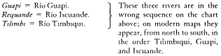
Sta Barbara = the town of Pizarro.
Gallo = Isla del Gallo. Francisco Pizarro waited on Isla del Gallo during 1526 while Diego
de Almagro returned to Panama for reinforcements; he moved to the larger Isla Gorgona
(see Chart 46n) 90 miles (144 km) north when Isla del Gallo proved too small. On
the mainland near Isla del Gallo is the town of Pizarro.
Arastra = Río Amarales (mouth of the Río Tanaje).
Estero = Río Curay.
Rio de Maldu = Rio Chagui.
Rosario = Río Rosario.
Surhidero de los Navios = Ensenada Tumaco.
Rio de Mira = Río Mira, 150 miles (240 km) long.
Gorgonilla = Islote Gorgonilla. This island is located 70 miles (112 km) too
far south on the above chart; it actually lies close by Isla Gorgona.
wee first left Panama and they had Come up hither in search of us and here unfortunately mett there ruine.[101] ffrom the Island Gallo, wch is in north latt.


[101] See Introduction, p. 11, for the fuller story.
Image not available.
Chart 48
Pta Manglares att first Sighte* all Low Land
Pta de Manglares = Punta Manglares ('manglar' = mangrove).
Ancon de Sardina's = Bahía de Ancón de Sardinas—Sardine Bay. This is a shallow bight
33 miles (53 km) long in which there are numerous openings that resemble the mouths of rivers.
Rio de St. Jago = Río Santiago, 100 miles (160 km).
ing there Neiboures, by that meanes decreasing faster then Nature gives Increase, but a truer reason is the Spanish tiranny hath drove these poore Natives into such unwholesome places of Bogges and ffennes yt the ill Vapours[102] of the Earth consumes more then theire warrs. At the End of this bay there doth begin high land and the Coaste bends away to WSW as far as cape ffrancisco. This river of St Jago is a very greate river but ships enter not, though the Spaniards have a small Village 3 leagues up it and they say there is 4 ffathom at its mouth. If you would Enter, Encline to the SE side and when you are over the barre there is very deep water. It is a mile broade. It is the highest land of all this Coaste except Matteo to wch is 7 leagues. Here ships have masts yards or provisions. It is inhabitted
[102] In this very wet area, low-lying land is apt to be inundated, like fens, or full of water-soaked vegetation, like bogs.
Image not available.
Chart 49
Baya de San Matteo = Bahía San Mateo, at the mouth of the Río de Esmeraldas (50 miles
[80 km] long). Hack f. 60: "The Bay of St Matheo . . . is posest by Indian warriours (who
will hurt no strainger) & here is sold by the Mullata's all sorts provissions. But I give
you a Caution of 2 things which are of great importance Vizt 1st not to Jest with there
women or debauch them; 2dly not to threaten the natives; with armes or otherwise but treat
them with humility you may have what you please."
la baya de San Matteo 10 or 12 leagues dist:
Tacames = Población de Atacames.
Puerto de La Galera = Bahía de Atacames.
Pta Galera = Punta Galera.
The dotted symbol off Puerto de La Galera is an extensive coral reef (Arrecife de Atacames).
by Spanish Mottattoes & Indians. To leeward of this bay 3 leagues is a river where wee watred when the Sn Pedro was taken by us the second time.[103] Wee fetched our water 3 mile up the river. If you would enter into the bay keep to the SE side. It hath North Latt

[103] The buccaneers captured the San Pedro for the second time near Cape San Francisco on July 8, 1681. According to Ringrose, on that occasion she carried 37,000 pieces of eight. Her previous capture in Panama Bay on May 10, 1680, had yielded 57,000 pieces of eight, wine, and gunpowder.
Image not available.
Chart 50
Pta Galena all NW.
Cavo de San Francisco = Cabo de San Francisco.
el Portete —the mouth of the Río Portete.
Ties Rios de Los Coxemies —there are a number of mouths to a large lagoon (Estero Cojimies)
into which drains the Río Cojimies. Hack f. 61: "I give you to understand yt when you com to
or near the Latt of yc Port of Quemado: that if any Birds which are call'd Mariposas coms on
board that you are within 5 or 6 Leagues of the shore; & allso I advise you that if at any hour
in the night you hear a bird call'd Graja that then you tack & stand of to sea: steering N W
if possible you can with small sailes. Both this I have experienced. I made a voyage takeing my
departure from this said Cape. . . ." [We do not know who is talking here. It was certainly not Hack.]
Coaque = Carrizal.
Serra de Coaque = Montanas de Cuaque, up to 1,000 feet (305 m).
Rio de Sama = Río lama. The equator is just north of Río Jama.
Hack f. 62: "On the shoalds of Jama, Domingo Antonio by going to near the shore
was cast away the ship was call'd Gonzalo Baltran; this was in the year 1612."
are rocks for halfe a mile. Here are Indians who will have hoe Comerse with the Spaniards who are forced if they want water to goe a shore armed. Here is noe very good water butt such as it is you will find in a lagoone a quarter of a mile within land at a river wch in the seasons runnes into the Sea. From this Point to Cape ffrancisco[104] is 2 leagues. It is a high Cape but it is far higher within land being North and South with it. It seemes an Island and from windward it seemes 3 capes. It is a woody mountenous land and hath white cliffs. From hence to El Portete is 3 good leagues, the Coast SE. It is a rounde hill behind wch is good wood and water and very smoothe landing. It hath a white cliffe at the head of it. You doe anchor in good grounde. Sometimes, though seldome at noones, there springs a wind from Shore wch will drive you from your anchor if you bee not carefull.[105] From Portete to
[104] In his journal (Aug. 5, 1680), Ringrose likens Cape San Francisco to Beachy Head in the English Channel.
[105] Such offshore winds blow down the Pacific slope of the Andes, which in this area reach elevations up to 20,000 feet (6,000 m) within 125 miles (200 km) of the coast.
Image not available.
Chart 51
Enseñada de Bocia Borachos = Punta Borrachos ('borracho' = intoxicated)—bare white
cliffs fronted by a long sandy beach in this bay.
Cavo Passao = Cabo Pasao = Cabo Pasado, where the Rosario was captured (see Introduction, p. 21).
Passao
La Canoa = Río de Chone.
Baya de Caracas = Jaramillo.
La Canoa
Baya de Caracas
Pescadores —a fishing settlement ('pescador' = fisherman).
Passao al sur —two views of Passao from the south.
S b E
the first river of the Coxemies is 3 leagues. There are 3 of them wch take 4 leagues in length of the Coast. They are full of Shoales, in some places a league of into the Sea, soe when you come aboute 2 leagues from Shore, you will do well to Sounde, but to windward of these 3 rivers you may come nearer the land, but it is all along not very deep as far as Coaque 6 leagues distant from hence SbW. In this bay you have 11 fathome water and one the shore soe many white cliffes wch appeare like heapes of Salt. Over this place doth pass the Equinoctiall[106] and you may anchor close under these hills out of danger of the wind if you have Occation. From this bay to Cape Passao[107] is 12 leagues WSW, all along deep water and close under Shore you may ride to Leeward of this cape. You will find people in a small Village of 20 familyes. When you would enter have a care of
[106] The equinoctial is the terrestrial equator, where day and night are equal. It is from this great circle that the modern country of Ecuador takes its name.
[107] It was off Cape Passao (or Cape Pasado) that Sharp captured the Rosario , from which the charts and sailing directions that gave rise to thc waggoners of Ringrose and Hack were taken. See Introduction, pp. 21-23.
Image not available.
Chart 52
Cape Lorenzo = Cabo de San Lorenzo.
*pt di Cama = Punta de Jaramijo.
Manta = Ciudad de Manta; center for production of Panama hats.
Cape Lorenzo
of Severall rocks wch lye right of from the cape. It is in South latt.

Image not available.
Chart 53
Monte Xpo SE = Cerro de Montecristi, 1996 feet (609 m); three views, as indicated here and
at Xpo al Norte and Xpo al SW on this chart.
Plata al Nort = Isla dc La Plata, 590 feet (180 m) ('plata' = silver); three views, as indicated here and
at Plata al N.E . and Plata al NbE on this chart.
Plata al N.E.
Xpo al Norte
Sta Helena al SbE = Punta Santa Elena, a narrow promontory at the northern point of Golfo de Guayaquil,
appears as an island when seen from the sea. The hill at the point is steep anti flat-topped, 297 feet (90 m);
two views, as indicated here and at Sta Hellena al Sur on this chart.
Sta Hellena al Sur
Plata al NbE
Xpo al SW
It is 4 foot under water and makes a greate Sea. From this Port to Cape Lorenzo is 6 leagues. Over the port of Manta is Monte Christo and the Shoale is from it NbW. This is a very high hill. There are 2 or 3 more hills to the westward of it but are not soe high. On this Coaste the wind blowes at SW & West South West and there runnes such a Current to leward about this cape that some ships cannot in a long time gett to windward of it. We were 3 dayes.[108] From this Cape 4 leagues SW is an Island called Plata wch is soe called from Sr ffrancis Drake his shareing of plate there.[109] I have been here twise and have founde good Turtle, Goates, & fish.[110] It lyeth in one degree

[108] Throughout the year, the Southeast Trade Winds blow more or less parallel to the coast between about latitude 40° south and the equator (with occasional diurnal modifications due to land and sea breezes); these winds are intimately connected also to the north-ward-flowing Peru Current, which occurs fairly close inshore on all but a few days of the year. This prevailing wind and current affected a sailing ship in two ways that have particular relevance to our story: first, since the wind was so important to everything they did, seamen tended to describe anchorages and so on with the terms windward and leeward rather than south and north (see p. 186, for example); and second, when sailing southward, since coasting was impossible because of contrary wind and current, it was necessary to take a long offshore tack into the Pacific, as Sharp did in the Trinity —forty-three days from Guayaquil to Arica (Sept.-Oct. 1680): twenty-nine days from Ilo to Coquimbo (Nov.-Dec. 1680): thirty-nine days from Arica to Coquimbo (Feb.-Mar. 1681): and finally, sixty-one days from Paita to Patagonia (Aug.-Oct. 1681). Northbound, there was every advantage in coasting—which Sharp exploited to the full, the 1,800-mile voyage from Huasco to Isla la Plata (Mar.-Apr. 1681) taking thirty-two days at a mean speed of 2.4 knots.
[109] In Bucaniers of America (JP3 , 63), Ringrose details Drake's exploit of late February 1579 as follows: "This Island received its name from Sir Francis Drake and his famous Actions. For here it is reported by tradition, that he made the dividend, or sharing of that vast quantity of Plate, which he took in the Armada of this Sea, distributing it unto each man of his company by whole bowles full. The Spaniards affirm unto this day, he took at that time twelve score Tuns of Plate, and sixteen Bowles of Coyned Money a man; his number being then forty five men in all. Insomuch, that they were forced to heave much of it over board, because his ship could not carry it all. Hence was this Island called by the Spaniards themselves the Isle of Plate , from this great Dividend, and by us Drakes Isle. " According to Fletcher (1628, 59-60), the amount involved was "a certaine quantitie of jewels and precious stones, 1??. chests of opals of plate; 80. pound weight in gold; 26. tunne of uncoyned silver; two very faire gilt silver boules, and the like trifles, valued in all at about 360,000 pesoes."
[110] Ringrose relates: "The next morning very early, about six of the clock, we came under the aforesaid Isle of Plate , and here unexpectedly, to our great joy, we found at anchor the ship of Captain Cox , with his whole company, whom we had lost at sea for the space of a whole fortnight before. We found they had reached this Island, and had been there at an anchor four days before as, being now just ready to depart from thence. About seven we came to an anchor, and then the other vessel sent us a live Tortoise, and a Goat, to feast upon that day; telling us withal, of great store of Tortoise to be found ashoar upon the Bays; and of much fish to be caught hereabouts"; furthermore, said Ringrose, "goats . . . there run wild up and down the country" (JP3 , 61, 62-63). With these feral goats and native marine animals, the buccaneers provisioned their ship plentifully.
The Trinity and her company anchored off Isla la Plata twice—July 10-17, 1680, on the way south just before the long board into the Pacific to reach Arica, and August 12-16, 1681, on the way north just after the capture of the Rosario .
[111] Flaw = a sudden gust or squall of wind, usually of short duration.
Image not available.
Chart 54
Cape Lorenzo = Cabo de San Lorenzo.
*Rio Picoaza = Río Jipijapa.
*pta di Cullo = Punta de Callo ('callo' = tongue, in Quechua).
Salango = Isla Salango.
Los Ahorcados = Islotes Los Ahorcados ('ahorcado' = one who has been hung by the neck):
these islands were the site of executions, as noted by Ringrose.
Colanche = Islote Pelado. The town of Colanche is 5 miles (8 km) inland; see also n. 112 (Chart 55).
Sta Helena = Villa de Santa Elena.
el Cope
el Sal
Pta Sta Helena = Punta Santa Elena.
Although he shows three views of it on Chart 53, Ringrose omits Isla la Plata from this chart,
presumably because it was omitted from the derrotero he was copying. It should be placed
just below the border of Chart 54A, under Cape Lorenzo , which is where Hack places it on
some of his versions of the same chart (f. 57 in the Greenwich Waggoner), often calling it Sir
Francis Drake's Isle.
ffrom Plata to Salango is 6 leagues SE. From Salango Northward is the Port of Callo, a good port. A league up from it is the towne of Picoaza wch in time of the breezes is a better port then that of Manta. ffrom Plata to Pta de Sta Hellena South is 18 leagues. Here aboute is a stronge leeward Current. SE from the Island Salango are two rocks called Los Ahorcados because one Machicao hanged two Spaniards there. These are Distant from Salango 3 leagues, and Deeper in the bay 3 leagues is the Island of Colanche, where you may anchor very safe in 10 fathom water.[112] This Island is one league Distant from a river of the same name, a fine freshwater river from whence the[y] fetch water to serve the towne of Sta Helena, where there is exellent riding for ships but not above 4 fathom water, for there is not much water all along this coaste of low land. You must ride over against the Indian houses for you may see the towne. Here you may have any sort of provision if you have occation for it.
[112] The Bancroft Library copy of Hack's Waggoner (W7/A3 , f. 50) says of Colanche: "On this rock was cast away in the year 1644 a very riche shippe having then on board 15,000,000 pieces of 8; & 70 pieces of brass ordnance & lyes in about 7 fathom water." Ringrose amplifies this in his journal for August 18, 1681: "At this place, and upon this Rock was lost the ship afore-mentioned, that was ordered from these Seas, to the aid of our most gracious Soveraign, King Charles the First, late King of England . Said ship had on board, as the Spaniards relate, the sum of many millions of pieces of Eight: all which quantity of Plate was sent as a present unto our King. being then in his troubles, by the worthy merchants of Lima. " The editors have found no confirmation for this unlikely story. John Strong of the English privateer Welfare made an unsuccessful search for this wreck in 1690 (Bradley 1989, 174).
Image not available.
Chart 55
Pta Sta Helena = Punta Santa Elena.
Cerras de Chanduy = Cerro Chanduy, three peaks to 1,400 feet (427 m).
Estero de Chanduy = Chanduy.
Yla Verde = Isla Verde.
Pta de Alcatraces = Punta Alcatras.
Estero = Estero Salado ('salado' = salty).
Pta de Piedias = Punta dc Piedra ('piedra' = rock).
Pta de Balsas
Pta de Miel
Pta Goide
Guayaquill = Guayaquil.
La Matansa
Puerto de Dievelez = Eloy Alfaro.
Puerto de Da
Isla Rodriquez = Isla Santay.
del Rey
Leon
Bajos de mondiagon = Isla Mondragón.
Ro Alonde
Ro Montaña = Canal de Matorrillos.
el Naranjal = Canal tic Naranjal.
Rio de boli
Rio baleo = Río Baleo Grande.
Lo Alto de Tunbes = Cerros Los Amotapes.
Rio Tongoi = Río Tenguel.
Rio Machala = Río Machala.
Salte de Buij
Bajos de Paguell = Isla Jambeli.
Rio Tunbes = Río Tumbes.
La Puna = Isla Puná.
Pta Sa Bernard = Punta Cascajal.
Pta Españiol = Punta Buenos Aires.
Alto de Mala = Cerro Zambapala, 975 feet (297 m).
Pta Arena = Punta Arena.
las Salinas = Punta Carnero ('carnero' = sheep, ram).
Cambray = Isla de Santa Clara.
Sta Clara

Sombrerett
Mancora = Máncora.
Pta de Mero = Punta Malpelo.
Cavo Blanco = Cabo Blanco.
Golfo de Guayaquil, shown on this chart, is the largest inlet on the west coast of South
America north of Isla Chiloé (42° S). The gulf extends from Punta Santa Elena
on the north to Cabo Blanco on the south and is 126 miles (203 km) wide at the mouth.
Righte off from the pointe are sunken rocks. If you would enter the port by night, stand not in for Shore till the high point of land bee withoute you. It showes at distance to bee an Island. An 100 Leagues from Passao west are severall greate Islands Called Los Galapagos.[113] From Hellena to Cape blanco is SSW 38 leagues. The Point and Sta Clara are NWbN & SWbS. The Point with Chanduy is ESE & WNW 5 leagues. Here it is fful of Shoales. If you would Saile from the pointe to Sta Clara or Tunbes, have a care least the Current Cast you into the bay further then you think for soe be sure to mind the tides. It is high water at La Puna and Sta Clara at moon setting.[114] From Sta Clara to Pta de la Arena you Saile ENE. They are distant 8 leagues. Betweene these two Islands there is no passage for a greate Ship. From Pta de la Arena to Pta de Bay is other 8 leagues. This is the port of Lapuna. From hence to the City of Guayaquil is other 8 leagues. This is a very difficult
[113] For a delineation of these islands, see Chart 107 and notes to that chart.
[114] The tides "follow the moon," meaning that, at any one place, high water always occurs approximately the same number of hours and minutes before or after the moon crosses the meridian, that quantity being known today as the "tidal establishment" of the place. It is usual to give the establishment with reference to the time of the moon's southing, not to moonset as Ringrose has done here.
Image not available.
Chart 56
From these hills the River of Guayaquil springs
Embarcadero in winter
Bridge
Embarcadero in summer
St Juan de Pimoche = Pimocha.
Amores
Rio Pimoche
Pueblo de San Pedro de baba = Samborondón.
Rio de baba -= Río Los Tintos.
Caranca = Hacienda Barranca.
Barranca
Puiblo daule = Pascuales.
Rio Daule = Río Daule.
Hernando
Rodriguez
Guayaquil = Santiago de Guayaquil, the principal port and largest
city of Ecuador, founded in 1536 by Sebastián de Benalcázar.
foit
Rio de Quilca
Rio de Chilintomo = Río Juján.
Puiblo de Chilintomo = Baquerizo Moreno.
el Contador
Yaguache el Cone = Yaguache Nuevo.
Rio de Yaguache = Río Chimbo.
Juan de Nova
el Vermejo
Belin
? noavioso
Taura
? el mauso
Isla dell Rey
fales
This chart shows the drainage area of the Río Guayas above Guayaquil. The Río Guayas
is formed by the confluence of the Río Babahoyo and the Río Daule 4 miles (6.5 km) above the city.
Channell and many Severall wayes are given to Saile it, but few good ones, for the ablest pilott of the South Sea will not think it a disparagement to bee beholding to one of the Indians of La puna or Sta Clara to guide him up, but Capt Perallto[115] hath often told mee that his way was to sounde all along & when bee founde not above 6 ffathom to goe aboute and by that meanes had Carryed up severall. This city of Guayaquil is a greate towne, the best built of the South Sea and richest for gold, it being the Embarcadero for the greate city of 80 leagues up called Quito,[116] where they make good broade cloth. Here are many greate and rich townes in this gulfe. The Governour of this Guayaquill came out with Soldiers in a Ship to fighte us but wee kept him from Returning for Some months & Caryed him and severall more of the Chiefe of them wth us a long time.[117] The land of Tunbes is the subject of a Spanish
[115] Captain Peralta was captured at Perico in April 1680 and was kept prisoner by the buccaneers until put ashore at Coquimbo in December of the same year. It is obvious from Ringrose's diary that the two became friends in spite of the unfortunate circumstances (see Introduction, pp. 9 and 16).
[116] Quito, the great city of the interior highlands behind this coast, lies 190 miles (300 km) north-northeast of Guayaquil. The commodities mentioned and others, including cocoa nuts, were traded through the port of Guayaquil (JP3 , 71).
[117] The governor's action is graphically described by Ringrose (JP3 , 72-85). Almost more important to the buccaneers than the governor, however, was the capture on this occasion—in August 1680—of the pilot Nicholas Moreno, who was the only prisoner retained on board after the others, including Peralta, were put ashore at Coquimbo in December 1680 (see Introduction, pp. 14 and 16). Moreno was put ashore at Nicoya five months later.
Image not available.
Chart 57
Cape Blanco al Sur = Cabo Blanco, the southern entrance point of the Golfo de Guayaquil,
with inset showing this feature from the south.
These hills are seene within land —Cerro Los Amotapes, with peaks to 5,300 feet (1,616 m).
Rio Tunbes = Río Tumbes, 110 miles (177 km) long. The many mouths of the Río Tumbes lie north
of Punta Malpelo. In 1527, Diego de Almagro and Francisco Pizarro, on their second voyage south,
reached the active Incan port of Tumbes (on the Río Tumbes) and established friendly relations.
On their third voyage in 1531, which resulted in the conquest of Peru, they landed at Caleta La Cruz de
Pizarro, just south of Punta Malpelo, and found Tumbes in ruins, the result of an Incan civil war.
Sombrerett —'small hat.'
here ends the mangroves
Pta de Moro = Punta Malpelo. At this point, at the apex of the Río Tumbes delta, the luxuriant
vegetation (including mangrove) of the tuner part of Golfo de Guayaquil ends, with only brushwood
growing on the desert coast to the south.
Mancora = Puerto Máncora.
Cape Blanco = Cabo Blanco.

Story. They say that the first settlement of the Spaniards in the South Sea next to Panama was here were they first came, two preists went a Shore with Crosses in there hands while 10000 Indians Stood Gazing on them. It happened that two Lions and two Bears came forth of the woods and the preists streachmg out there armes the savage beasts Came and worshiped the cross and became very tame.[118] In this Gulfe the Spaniards build greate ships. From Pta de Mero to Cape blanco is 16 leagues, a very windy Coaste espetially off of the Cape wch is in South latt.

[118] This event, which prompted the Indians to accept Christianity, was related to the English buccaneers by the Spanish prisoner Captain Peralta aboard their ship (JP3 , 76; the journal account speaks of tigers instead of bears). Although no historical evidence exists to support this story, it is said that this area is where the Spaniards landed in 1528.
Image not available.
Chart 58
Cape Blanco = Cabo Blanco. Between here and Punta de Pariñas lies the modern
city of Talara, the center of Peru's petroleum industry, just south of Punta Malaca.
Malaca = Ensenada de Malaca.
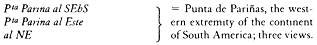
Spaniards lost a ship with there pilott Michaile Angell. Pta Parina is low land and at Distance lookes like 2 small round Islands. There alwaise runnes a greate sea here abouts.
From this point to the Port of Paita is 8 leagues low land to sea boarde. The Coaste runnes SSE. Within land are the high hills of Motape. This is a very good Port. The towne Consists of 250 ffamelyes, nor 4 of them Spaniards borne to this towne. The City of Piura come to Trade. This City the Spaniards say is 4 times soe bigge as Paita & distant from it 13 leagues in the roade to Lima wch is a greate roade for those persons whose Business Calls them from Lima to Panama or from thence to Lima, and whose stomachs cannot brooke the sea doe travell by land to Paita or from it to lima.
Image not available.
Chart 59
Serras de Motape = Cerros Los Amotapes, with peaks to 5,312 feet (1,619 m).
Pta Parma = Punta de Pariñas.
Rio Colan = Río Chira, 100 miles (160 km) long.
Colan = Colan.
Puerto de Paita = Puerto de Paita, today a major port and cotton area.
Pena Oradada = Punta Ayoyero (phonetic local variant of 'agujero,' or hole = 'horadado.' pierced).
La Silla de Paita = Cerros Silla de Paita.
Above Piura is a greate towne Called Loxa from wence they bring much gold to Paita. Paita hath felt the force of the English, for May 10: 1598 Sr Thomas Candish took it & burnt it only with 60 English routing 300 Spaniards.[119] In the yeare 1681 wee were before it[120] but they had stockadoed the towne aboute and had there the whole strength of Piura, Loxa & Colan, wch is but 2 Leagues distant to leeward on the bay, twise soe bigge as Paita. A league WSW from Paita is Peña Oradada. Thence one League SW is the Island Lobos. Paita is South Latt.

[119] See n. 34 for an account of the capture by Cavendish of the Spanish treasure galleon Santa Ana six months after his attack on Paita.
[120] See Introduction, p. 23, for a fuller account.
[121] Dampier gives a detailed description of bark logs in his New Voyage Round the World (JP4 , 141-43), as rafts with mast and sail that could sail only with the wind astern, although the larger ones did have a rudder. Small bark logs for fishing, taking water out to ships, and so on—and presumably the type referred to here—had four or five logs lashed together and a capacity up to about a ton. They would put to sea at night with the land breeze astern (it is fairly consistent on this coast), returning with the sea breeze in the afternoon. Large cargo-carrying bark logs could have a hull of twenty or thirty great trees 20 to 40 feet long, be several 'stories' high, and have a cargo-carrying capacity of 70 tons, generally of wine, flour, sugar, cloth, and skins. Dampier concludes (p. 143): "They always go before the Wind, being unable to ply against it: and therefore are fit only for these Seas, where the Wind is always in a manner the same, not varying above a point or two all the way from Lima, till such time as they come into the Bay of Panama: and even there they meet with no great Sea; but sometimes Northerly winds: and then they lower their Sails, and drive before it, waiting for a change. All their care then is only to keep off from Shore: for they are so made they cannot sink at Sea. . . . The Float is manag'd usually by 3 or 4 men, who being unable to return with it against the Trade-wind, when they come to Panama dispose of their goods and bottom [i.e., the bark log itself] together; getting a pasage back again for themselves in some Ship, or Boat bound to the Port they came from; and there they make a new Bark-log for their next Cargo."
Image not available.
Chart 60
Silla de Paita = Cerros Silla de Paita.
Peña Oradada = Punta Ayoyero.
Lobos = Isla Foca ('lobo' = wolf; hence sea-wolf, or seal). See n. 124.
Ensenada de Sechura = Ensenada de Sechura.
Sechura = Villa de Sechura, on the banks of the Río Piura, 150 miles (241 km) long. Piura, located
35 miles (57 km) up the Río Piura, was founded in 1532 by Francisco Pizarro; originally named
San Miguel de Piura, it is the oldest Spanish settlement in Peru, but it does not appear in Ringrose.
Pta Pisura
Nonura —town abandoned at an uncertain date. The modern oil terminal of Bayovar is probably on the same site.
Pta de la Aguja
the bay is the Village of Sechura of 30 or 40 houses of Indians who gett there livings on the fishing trade for those Sardina's. Nearer to Punta Aguja is a small Village called Nonura, wch is as good a port as is that of Paita. It is a Country full of Indians. The pt is a long high hill and to Eastward & westward of it are many Rocks, but they are not dangerous because they are very neare the shore. It is all a long a barren Sandy Coast, not having one stick of wood nor no good taking in of water for any ship, wch is the Cause of the little trade it hath, but up in the Country is plenty of all things.[122] The Indians are greate Slaves to the Spaniards. I have here drawne it as it appears at severall pts of the Compass from you.[123] It is in South latt.
[122] This is the northern part of the hot desert coast of South America, which extends from 5° to 30° south latitude.
[123] Despite the wording here, the views on Chart 61 seem to have been copied from the same source as the other charts, and are not likely to be from Ringrose's own observation.
Image not available.
Chart 61
Image not available.
6 degrees. From hence the Coast runnes Nearest SE as far as the port of Saña, Wch is 36 leagues distant from the Southward End of Aguja. To the Southward Island Lobos is 6 leagues SE. This Island is 2 good leagues from the maine land. It is a Rocky Island only used by Indian ffishermen. I would not advise any ship to pass betweene it and ye maine for the Spaniards have lost severall ships by it and there is nothing of Provision or anything else to be had near it. It is Seven leagues South from the other Lobos (not that Lobos near Paita) wch is twise so bigge as this, this not being a league long, but they both have plenty of fish.[124] I have found this to bee n Latt.

[124] In his account Ringrose mentions three Islas Lobos (seal islands: lobo de mar = seal), apparently close to each other but in reality encompassing some 120 miles: (1) his Isla Lobos between Paita and Sechura on Chart 60, charted today as Isla Foca (foca = seal) and the site of a lighthouse; (2) his "other Lobos" (the "Northward Island Lobos" on Chart 62), known today as Isla Lobos de Tierra, fifteen miles from shore in 6°25' S; and (3) the "Southward Island Lobos" on Chart 62, known today as Isla Lobos de Afuera or Isla Lobos de la Mar, thirty-five miles from shore in 6°55' S (Ring-rose gives its latitude as 6°20' in the text, 6°50' on Chart 62). Actually two islands separated by some 150 yards, the "Southward Island Lobos" was much used as an anchorage by later buccaneers.
Image not available.
Chart 62
the Northward Island Lobos al NE, tres Leguas = Isla Lobos de Tierra ('Seal Island'). See n. 124 (Chart 62).

Pta Aguja = Punta Aguja.
Lobos
Morro de Etten = Morro de Eten, 640 feet (195 m).
Lobos
*

to Cherripee is the River Saña wch leads to a citty of the same name 3 leagues up it. The Citty hath 7 Churches and aboute 500 ffamelyes. At Cheripee ships loade Corne[125] for Lima and Panama, though there runnes a very greate sea. A mile right off from the port of Cheripe is a shoale wch you must take heed of. Farther along is the port of Pacasmayo[126] where they likewise lade corne but a very open road and greate sea. The best mark to know this bay is by the numerous flights of small birds wch are alwaise in this bay and not any where else near it. Here is no water unless you goe a mile within land for it, to the noe small Discomoditye of the Inhabitants, but some make there living by bringing it to the sea side and selling it to ships that stop here.
[125] Corne" here is possibly Indian corn (Zea mays ). but it could mean any of several Old World grams or cereals—wheat, barley, oats, etc.
[126] Of Pacasmayo Hack says (f. 80): ". . . but you must look after your Cables otherwise the ratts will do them damage."
Image not available.
Chart 63
Civdad de Saña = Zaña, 15 miles (25 km) up the Río Zaña, abandoned during the colonial period.
Quebrada
Pico Alto = Cerro Facio, 1,731 feet (528 m).
Pacasmajo = Villa de Pacasmayo.
Cerras San Pedro
Morro Malabrigo = Morro de Malabrigo, 812 feet (248 m) ('malabrigo' = poor haven).
Rio de Saña = Río Saña (or Zaña), 60 miles (97 km) long.
Ermito tambo
Pta Cherrippe = Punta Chérrepe.
Rio fequantepeque = Río de Jequetepeque, 100 miles (160 km) long.
Further is the port of Malabrigo wch is known by its high hill, wch hath a hollowing in the midst. It is an ill port and is in south latt.

[127] Of Guanchaco (Huanchaco) Hack says (f. 83): ". . . & there is Ratts that will damnify your Cables: this I have experienc'd. Likewise you must take Care to weigh your Anchors every other day or els when you would: you cannot they will sinck so deep in Ooz."
[128] "Iron shore" = a rocky and steep-to coast without anchorage.
Image not available.
Chart 64
Malabrigo al. Este 5 leguas
Campaña de Truhilio al NE = Cerro Campaña, 3,268 feet (997 m).
La Madalina = Magdalena de Cao, today a large sugar-producing area.
Rio Chicama = Río Chicama, 50 miles (80 km) long.
Pta de Cao
*guanchaco = Huanchaco.
Truhilio = Trujillo.
Puerto de Guanchaco
ffarellon de Malabrigo al NW = Islas Macabí.
Campaña to the NE of you. Here runnes a very high sea soe that in the smoothest time it is dangerous Going a shoare in a boate, but they use barque loggs to bring of there Corne. On it is high double land in the Country, but Campaña de Truhilio is at the sea side. The city is two leagues from the sea side in a brave, rich, pleasant, fruitefull Country, having 2 crops of Corne in a yeare.[129] Hence runes along the bay of Guanapee which is no good port, no more then the rest. The port of Truhilio is in latt.


[129] This productive agriculture was made possible through irrigation as meltwater from the snow-covered mountains flowed through exotic streams across the desert coastal plain.
[130] "NNW 1/2 N" = north-northwest a half north, half a compass point (5°37'30") to the north of NNW. NNW 1/2 N and SSE 1/2 S are reciprocal bearings giving the trend of the coastline.
Image not available.
Chart 65
Rio de Truhilio = Río Moche.
Moche = Moche.
Puerto Chuelo = Salaverry.
Morro de Guanape = Cerro Prieto de Guañape, 755 feet (230 m).
ffrom this Island of Guanape to the Island of Santa is 10 leagues SSE and in the mid way is the Island of Chao, betweene wch and Guanape are many Shoals, very Dangerous, therfore Carefully to bee avoyded. The bay of Chao is a good port but here is no water, but at the towne a league up, NW from the port of Santa, is a Shoale though not near a quarter of a mile out, but have a care of it for you will not perceive it till you are on it. It is a good porte and you may have provisions and wood and water. When you enter the Port look out for a streake of white sand wch is like a Roade and is within land near fferroll and having Discovered it you may safely anchor before it in 4: 5: or 6 fathom water and good Grounde.
Image not available.
Chart 66
Morro de Guanape = Cerro Prieto de Guañape.
Rio Guanape = Río Virú, 50 miles (81 km) long. The town of Guañape is today called Virú;
it lies some 8 miles (12 km) inland.
Chao —there is no town here today, only a pier.
Puerto de chao —at Punta Chao.
Morro de Chao = Cerro Salina, 1,480 feet (451 m).
Isletta = Islas Chao.
Rio de Santa = Río Santa, 200 miles (322 km) long—one of the largest and
most rapid rivers on the coast of Peru.
Santa = Puerto Santa.
Morro de Santa —a peak on Península de Santa, 515 feet (157 m).
Corrobado = Islote Corcovado ('corcovado' = hunchbacked).
Isla de Santa = Isla Santa, 475 feet (145 m).
You may saile between the Island Santa and the maine but have a care of a small Island wch lyes betweene them. The Island Santa is a league long and hath South Latt.

[131] Typical onshore breezes are occasioned by a cool ocean current with upwelling and a high daytime temperature on the coast: the seaman's daytime "sea breeze."
Image not available.
Chart 67
These hills are far up in the Country
Morro de Santa —see Chart 66 n.
Chimbote = Chimbote.
Bacas de fferrol = Islotes Ferrol, three main islets ranging in
height from 250 to 500 feet (80 to 150 m).
Morro de fferrol al Este = Cerro Peninsula, 1,778 feet (542 m).
* Puerto de Guanbacho = Bahía de Samanco.
Isla de Santa = Isla Santa.
Side under water and you cannott see it but at low water and then it is a fathom and halfe under water, but between this Shoale and the maine is 17 ffathom water. It is two good Stones casts[132] from the maine. You may Enter on the north side and anchor in 6 ffathom water, close under a white hill which you may come very near to. This port hath South lattitude

[132] At sea, the phrase a musket shot —rather than a stone's cast (or throw ), as here—was generally used to indicate a shortish distance.
[133] Of Vermexo (Vermejo = Puerto bermejo on Chart 69), Hack says (f. 90): "In this port of Vermejo is sweet water: it is to be found 10 or 12 steps from the water side at which distance dig & you will find the water rise: it is Indiferent Good. . . . The product of the vally's is brought down to this port in waggons & from thence transported to Lima & : but here is no people dwells near the sea side: & the Fort that is in the bay is made of Linga" (possibly a wooden fort of logs of the Chilean tree lingue , of the genus Laurus . On his Chart 69 Ringrose shows the symbol for a fort at Vermexo without naming it. On Chart 70 he shows the same symbol, named "the fort of Linga," some considerable distance south of Vermexo).
Image not available.
Chart 68
Mongon al SE
al NE
*punta chinos = Punta Samanco, the southern point of Bahía de Samanco.
Hack f. 88: "Port of Chinos by ye name of ye Tortoishell."
Pueito de Los Chinos =Caleta Los Chinos.
Puerto de Casma —on the Río Casma.
Isletta
Mongon = Cerro Mongón, 3,743 feet (1,142 m)—the highest and most prominent feature
on this part of the coast, with a rounded appearance; two views here, al SE and al NE.
ffrom the Port Vermexo to the Port of Guarmey is 4 leagues. From Casma hither the Coast runnes South. Within the port is a white rounde Island. You must ride to windward of it in 8 fathom water. The port is peopled with Indians and Sambo's[134] but a league up is a good towne of Spaniards of 100 ffamelyes. Here is a small Rivulett of water wch in winter runnes into the Sea. This port is in South lattitude

[134] ee n. 43.
Image not available.
Chart 69
Mongonsillo = Colina Redonda, 1,683 feet (513 m)—on the south flank of Cerro Mongón, at Punta Mongoncillo.
Guarmey = Pueblo de Huarmey, an oasis with fruit trees in a sandy desert on the Río Huarmey.
bridge
Caletas —'coves,' of which there are many along this coast.
Puerto bermejo = Manache. ('Port Vermexo' on p. 182.)
*

Puerto de Guarmey = Bahía Huarmey.
Hence to Permonguilla is a rocky Coaste. This place from Sea boarde seemes an Island, very white because of the fowles Dung wch lyes on it.[135] Hence to Rio de la barranca is 10 leagues. Near to Permonguilla stands an old decayed Indian fort Called the fort of Linga where the Spaniards have Massacred thousands of the Poor natives as by some Sculls seen there to this day.[136] Near to the River Barranca stands the Old towne of Baranca but the new towne is built near there Port wch is a deep bay but little wood or water. The Coast along is full of high white Cliffs and not very high land in the bay and Port of Supe. The land is low to Sea board but all
[135] Ringrose refers here to the guano-covered islets that are conspicuous features on this coast. The guano, high in nitrate, was later mined for export as fertilizer.
[136] Ringrose was very critical of the Spanish treatment of the native populations. This treatment has been considered in depth by Sauer (1966), MacLeod (1973), Villamarín and Villamarín (1975), and Sherman (1979).
Image not available.
Chart 70
Cerro del Jaques de la Zorra = Cerro Las Tetas, 1,522 feet (464 m), with two peaks above Punta Las Zorras.
Pta de Gramandell = Punta Jaguey, which forms the southern side of Bahía Gramandal.
these hills are [continues on Chart 70B ]
seen over the sea coasts = Cordillera Occidental de Los Andes (Cordillera Negra), with peaks to 11,800 feet (3,600 m).
? Coches
Cerro del Injenio
the fort of Linga = Fortaleza de Paramonga, built by the Incas in the fifteenth century.
Permonguilla = Paramonga.
Rio = Río Fortaleza.
Rio Barranca —'barranca' = ravine. Here on the southern bank of Río Pativilon
is a steep cliff from which the town of Barranca derives its name.
old towne
new Barranca —today Población de Barranca extends as a strip settlement from the banks
of Río Barranca south to Supe.
Puerto de La Baranca = Bahía Barranca, useless to shipping owing to constant heavy surf and the steep
aspect of the coast.
*

Puiblo de Supe = the town of Supe, or Puerto Supe.
along very high up in the Country. From Barenca to this Supe is 3 leagues. It is an Indiferent Port. The Village hath near 40 ffamelyes. It is a Country ffull of People. Hence to the Island of Don Martin is 3 leagues. It is a small white Island a mile Distant ffrom the maine. It is halfe a league long. From hence to the leeward Port of Guaura is one league and to the windward Port is one league more.[137] In this windward Port ships ride where you have a River wch passes by the towne of Guara, a league up, Containing 100 ffamilyes. In this port is a hill wch hath two little ones on its top, at the leeward pt of wch you must ride in 9 ffathom. If a greate ship, have a Care of the windward Side of the hill ffor there abouts are many Rocks under water.
[137] On leeward and windward ports, see n. 108.
Image not available.
Chart 71
this is over Guara = Cerro San Cristóbal, 2,100 feet (640 m).
Guaura = Huaura.
bridge —the bridge at Huaura is over the Río Huaura.
Rio
Morro de * Guavra = Punta Carquín, with a fort.
Vicama
Guacho = Huacho.
Cerro de Salinas = Cerro Sanú = Monte Salinas, a prominent pyramid-shaped hill,
935 feet (285 m), taking its name from the saltwater lagoon at its base.
Pta Galera = Punta Lachay.
The Island of Guaura is in south lattitude


Image not available.
Chart 72
Pta Galera = Punta Lachay.
*

Marsaque = Isla Mazorca, the largest Island of Grupo de Huaura.
Malgesi = Islote Pelado.
La Chay
Pescadores —the fishermen's houses are located at Punta Grita Lobos along
the Ensenada Playa Grande, a bight that extends 20 miles (32 km).
Chancay = Chancay.
morro = Cerro Macatón, 1,988 feet (606 m).
Rio = Río Chancay, 70 miles (113 km) long.
Sierra de la Arena —peaks to 6,500 feet (2,000 m).
Puerto de Anton de Rodas = Bahía de Ancón.
Pescadores = Grupo de Pescadores ('The Fishermen').
ffarrellon de D na Franca = Islote San Pedro, anti several islets.
Boca negra = Bocanegra. The unnamed river north of Bocanegra is Río Chillón.
Ormigas = Islotes Hormigas de Afuera ('hormiga' = ant).
is 2 leagues. These Islands make a secure & safe Port. These are N & S with Calao. The City of Kings[138] or lima is 2 leagues up from Calao and Calao is its port. From Pescadores to the Islands Called Hormigas is 7 leagues WbS. ffrom Pescadores to the Island of Calao is 5 leagues. From Hormigas to the Island of Lima is ESE 9 leagues. The Island of lima is 2 leagues long and outward from it there is a small Key, and on the South Side of it are severall others, and in its place of Riding is a small high hill. From hence to Calao is a Chanall but not Easily found for the many Shoals in the way. The Port of Calao is a good port and the cheife of the South Sea for in Lima resideth
[138] Lima, or Ciudad de los Reyes (the "City of the Kings," named for the Wise Men at Christ's nativity), was founded in 1535. Seat of the viceroy of Peru and of an archbishop and, with its outport, Callao, home port of the Spanish Pacific fleet, it was the most important city of South America.
Image not available.
Chart 73
Image not available.
the Spanish Viceroy and to this port is broughte all the Gold, Silver, pearles, and Stones with Guineas[139] and other rich things that the South part of the World Affords. In Lima are 38 Parish Churches, 7 monasterys, 4 Nunneryes & one Colledge of Jesuists.[140] It is the Seate of an Arch=bishop and through it runnes the River of Lima. Its cheife church ffor Bravery & Relicts is that of St ffrancisco, the next St Pedro. In the first are 24 altars. In the next 17 altars. Calao is its port. It is walled aboute and hath 6 bastions made not in a Regular manner but 4 of them facing the Sea. Wth in the walls is a church and towne.
[139] A guinea was an English gold coin, issued from 1663 to 1813, which took its name from the Guinea Coast in West Africa, where gold was thought to have originated. Ringrose was perhaps referring to the Spanish real , which since 1565 had been minted at Lima.
[140] Lima is also the seat of the University of San Marcos, founded by a grant from Charles V in 1551.
Image not available.
Chart 74
Boca Negra = Bocanegra.
Rio de Lima = Rio Rimac, 80 miles (130 km) long. 'Lima' is derived from 'Rimac.'
Civdad de Los Reyes = Lima, founded by Francisco Pizarro in 1535 as Ciudad de Los Reyes ('City of the Kings').
Monte trigo
Aguada —'watering place.'
the way = Avenida Colonial, the main throughfare between
the harbor and the city center, about 7 miles (12 km) inland.
Calao = Callao, founded in 1537 and during colonial times the leading Pacific port. The site
of Castillo Real Felipe (with five towers, rebuilt in 1770), Callao was once separate from Lima,
but today the city is continuous to the coast.
*Callao in

Pitipili —probably the quay.
Isla de Lima = Isla San Lorenzo.
*

Peña Horadada —'horadada' = pierced, perforated.
Morro de Solon = Morro Solar, 932 feet (284 m), having the shape of a quoin, or wedge.
Lima is dominated by Cerro San Cristóbal, on top of which is a large cross. The city today has more
than fifty churches and numerous monasteries and convents and is the largest city and port of Peru.
Calao is ffamous not only for its being the Port of lima but also for that Sr ffrancis Drake did here Cutt loose 12 saile of Ships and took a Chest of Mony, feb. 13, 1579.[141] In this port lye all the Kings ships and never depart unless when the fleete comes from old Spaine to Puerto Velo.[142] Within land are severall greate and rich cityes as Cusco, Guamanga, &c.[143] The port Calao is in 12 degrees South lattitude. If you would ride in this Port of Calao, bring the towne South from you and you may anchor from 12 ffathom to 4 fathom. From the Island of Lima to Rio de Pachacama SE is 4 leagues, at whose mouth are severall Islands and Rocks, 8 or 9 in Number. From these
[141] According to the chronicler Pedro Sarmiento de Gamboa, who was at Lima at the time, this event took place on Friday, February 13 (new style), 1578 (Nuttall 1914): Fletcher (1628), however, says that the date was February 15, 1578. The two accounts differ; Gamboa reports that Drake cut loose seven of nine ships lying at anchor.
[142] The flora , or royal fleet, from Seville called at Puerto Bello, on the Caribbean side of Panama, to pick up goods from the Pacific coast of Central and South America that had been brought across the isthmus. See n. 26.
[143] Cuzco, the old capital of the Incas, elevation 11,500 feet (3,500 m), lies about 220 miles (350 km) from Lima, to which it was connected by a highway. Guamanga, now Ayacucho, is on the road between Cuzco and Lima.
Image not available.
Chart 75
Morro de Solon = Morro Solar.
Rio Pachacama = Río Lurín, which runs through the town of Pachacama.
Pico Alta de Chilca
Pta de Chilca—Punta de Chilca is actually the southern point of Caleta Pucusana, not the
northern as shown by Ringrose, off of which lies Isla Chilca (or Isla Chuncho), unnamed above.
Puerto de Chilca = Caleta Pucusana (or Puerto Chilca).
*Chilca = Chilca.
Rio de Chilca = Río Mala.
*M. Tambo
Isla de Asia = Isla de Asia, 120 feet (37 m), one of the most easily identified features on this
part of the coast, along which a wind called the 'paraca' disturbs the sea from noon to dusk.
Pta Asia = Punta Malpaso de Asia.
Islands to the Point of Chilca[144] is other 4 leagues. There is a towne Called Chilca 3 leagues up from ye sea side. From hence to Isla de Asia is 3 Leagues and from hence to the Port of Canete wch by another name is Called Guarco, is 8 Leagues. Here is a hill Jetting[145] into the sea, on the top of wch is a stone fort Built by the Indians who live about it. Within Land you see the high hills wch show righte off at sea as I have Marqued them. It is a Cleare Coaste along but much subiect to Calmes near the shore.
ffrom Canete to Chincha is 10 leagues SSE. It is a good port. Here is a greate traffick
[144] Of Chilca, Hack says (f. 99): "The Port of Chilca is the best & quietest harbour that is in all this sea: but it is so litle that it will not hold above 8 or 9 saile of ships at a time: but in it you ride landlockt from all winds." On folio 102 Hack says that cork and silver are exported from the port of Chilca.
[145] "Jet" = variant of jut , to protrude; cf. jetty .
Image not available.
Chart 76
These halls are seen over the low land = Cordillera Occidental de Los Andes.
Isla de Canete —consists of a reef with two above-water rocks named El Fraile and Ciriaco.
Today the town is called San Vicente de Cañetc.
Puerto de Canete = Puerto de Cerro Azul.
Rio Canete = Río Cañete, 120 miles (193 km) long. Cliffs from 440 to 550 feet (134 to 167 m)
run from Rio Cañete south.
Rio Herball
Pta Herball—there is a prominent clump of scrub on the lower part of the cliffs near Caleta Jaguay, which may
be Ringrose's P ta Herball.
To Arica for our wine and other Commodityes. Neer this port are 3 Islands wch show white and hath on them multitudes of Guanas[146] and about them greate store of fish. They lye SW from the port 3 large leagues. In this Port of Chincha ships ride in 7 ffathom water. From this Port 2 leagues up is a towne Called Sto Domingo. They Deale in wine & Brandy.[147] From Rio de Chincha to Rio de Lorinchincha is 3 leagues. Up the River is a Village of that name where they likewise deale in wine and brandy. It is a very pleasant healthy Country. From hence
[146] Iguanas, reptiles of the family Iguanidae; possibly the marine iguana (Amblyrhynchus cristatus ), found also on the Galapagos Islands. However, seafowl, from which guano is derived, were called guanoes by the buccaneers (JP4 , 101).
[147] This coast is famous for its wine and brandy (distilled wine) produced from the Old World grape (Vitis vinifera ), which the Spanish brought to the Americas early on.
Image not available.
Chart 77
Quebrada de Topara = Río Topara.
Rio Chincha = Río Chincha, 80 miles (130 km) long.
Sto Domingo = Puerto Tambo de Mora.
Rio de Guambramayo
Rio de Lorinchincha
Caucato = Caleta Caucato.
to the port of Pisco[148] is 3 1/2 leagues. This is the Greatest port of these seas for vending of wine and Brandy, and for it they are never without ships from severall other parts and have of there owne 15 saile. It is a vast rich town containeing neare 300 houses. They have a fort of 6 gunns. It is all along a Sandy Bay, and hath very good Riding for greate Ships in 5 or 6 ffathom and for smaller in 3 1/2 fathom water. Here is a good River for ffresh water. This Towne of Pisco is in South Latt.

[148] The locally produced liquor, pisco , a high-quality anisette, takes its name from this town.
Image not available.
Chart 78
Rio Pisco = Río Pisco, 150 miles (241 km) long.
Pisco = Pisco.
Isla Blanca = Isla Blanca.
Puerto de Paraca = Bahía de Paracas. Hack (f. 103) says local wines from
the valley of Yca are shipped from this port.
*M. Paraca = Monte Lechuza ('lechuza' = owl), 1,158 feet (353 m), on Peninsula de Paracas.
Ballena
La Ballesia = Islas Ballestas ('ballesta' = crossbow).
Isla de chincha = Grupo de Chincha.
*St. Gallan = Isla San Gallán.
*Lat .

Lagunilla = Caleta Lagunillas.
Ysla de Carate = Islote Zárate.
ffrom Pisco to Paraca is 3 leagues. On a bay here are 3 or 4 store houses for the towne is 15 or 16 leagues up in the Country. These deale in wine and brandy also. From hence to Morro de Sangallan is 3 leagues, off from whose point comes a shoale. When you come out of Paraca bee wary of it. All those ports are most exellent & smooth and all starke calme only from noon to 3 a clock after noon.[149] This Morro de Sangallan is in South latt.

[149] This mid-afternoon calm is occasioned by the strong land-to-sea diurnal temperature and consequent pressure gradients.
Image not available.
Chart 79
Morro de Vegas = Monte Carretas, 1,637 feet (499 m). The unnamed island to the right of the mountain is Isla de Las Viejas.
*14.20. Lat S. = Lat. 14°11' S.
Morro Quemado = Monte Quemado ('quemado' = burning) 2,070 feet (631 m), a remarkably flat-topped ridge
with a thick cap of reddish earth. Hack (f. 104) says that wines are shipped from the port but that Quemado
is a bad harbor, with no fresh water or wood.
Los Ollenos —guano-covered islet and pinnacles, lying south of Punta Doña María at Punta Olleros, which
is north of Río Ica. There are rocks to the north of the mesa called Islotes Infiernillos ('infiernillo' = little hell).
Messa de Dna Marta = Cerro La Mesa de Doña María Francisca (Punta Doña María) is a prominent truncated
conical mountain, 2,160 feet (659 m).
Rio de Yca = Río Ica, 100 miles (161 km) long.
Morro de Cavallo al NE = Morro Nazca, 1,020 feet (311 m).
another name is called the port of Lanasca that being a towne from whence comes greate store of wine & brandy. Distant from this port 15 leagues, it is in South latt.

Image not available.
Chart 80
Curacanguana = Cerro Huricangane, 5,660 feet (1,726 m), the highest point of a tableland.
Puerto de San Nicolas = Bahía San Nicolás.
*15.30 S . = Lat. 15°12' S.
Puerto de San Juan = Bahía San Juan.
Penascos —'rocks'; a reef extends half a mile off the coast here.
Penascos
Morro de Acari = Morro Chala, 3,740 feet (1,140 m).
*Acary
* 16.15 South = Lat. 15°45' S.
not ride for it is a windy place and here doth runne a greate Sea. From hence to Morro de Ariquipa is 9 leagues. Here you have high land and from hence you may see the high lands of Atico. This Ariquipa is a towne 18 leagues from the Sea Side and its port is in South Latt.

[150] See n. 149.
Image not available.
Chart 81
*Morro de Acari = Morro Chala.
Puerto de Chala = Puerto de Chala. The Río Atequipa flows into Caleta Quilquay
about 4 miles (6 km) to the east of Punta Chala.
Morro de Atiquipa —lesser peak below Morro Chala.
*Morro di Alico = Morro de Atico.
This Atico is very high land but hath no good place of Riding.
ffrom it to Ocona is 9 leagues SEbE, an Iron wild Shore. In the way are many hollowings in the land caused by severall rivers and close to shore are Severall Islands called ffarellones de los Pescadores.
ffrom Ocona to Camana is 6 leagues; the Coast runs SEbE.
Image not available.
Chart 82
Morro de Atico = Morro de Atico.
farellones de los Pescadores —'Rocks of the Fishermen' ('farallón' = a sheer rock that projects
out of the ocean). This coast is identified by four dark cliffs, from 600 to 1,000 feet
(183 to 305 m) in height, fronted by islets.
Ocaña = Caleta Ocona. Ocona was a Cinchona-growing center in colonial times. (' Cinchona
officinalis ' is an evergreen tree native to South America possessing medicinal properties; it
was named for the condesa de Chincón, wife of a Peruvian viceroy of the seventeenth
century, who was cured of a fever—possibly malaria—by the use of this bark.)
It is a good Port and is Peopled with Spaniards, and here they have much fruite as Olives, Peaches, apples, Pears, Plumbs, &c.[151] It is seldome without ships or Barques, it being a very good port.
ffrom hence to the Port of Chule is 12 leagues viz. to the Island Cornejo is 4 leagues. Thence to the Port of Hilay or Chilay is 5 leagues. Thence to Chule is 3 leagues. In Hilay is most exellent Riding. Within the keys in 50 ffathom water. This Chule is in South Latt.

[151] The Old World orchard trees olive (Olea europaea ), peach (Prunus persica ), apple (Malus pumila ), pear (Pyrus communis ), and plum (Prunus domestica ) have all been widely cultivated ever since the Spanish first brought them to the New World.
Image not available.
Chart 83
Camana = Camaná, famous for olive oil.
*Aquilca = Quilca, at the mouth of the Rio Vitor (or Quilca), 160 miles (258 km) long.
Hack mentions an abundance of fish here.
Isla de Cornejo = Roca Foca ('Seal Rock').
*Quebrada Cornejo —lies behind Punta Cornejo; the land beyond has
peaks up to 5,530 feet (1,686 m).
Pta Chilay = Punta Islay.
* Lat. 17.0 South = Lat. 17°00' S.
Los Almenos —translates roughly as 'crenelated,' like a battlement.
Chule = Mollendo.
the barre to unlade. Hether they bring the broade Cloath of Quito (wch hath often kept mee warme).[152] The passage is soe narrow here that butt one boate Can pass at a time. You may from hence see the Volcan of Ariquipa 18 leagues up in the Country.
Hence to Hilo is 16 leagues SSE. At Rio Tambo you have 18 ffathom water but a greate sea. The port of Hilo hath good water and a Village of Indians. I have been in this port twise, first in 1680, nex in 1681.[153] Here runnes out a long pt into the Sea wch hath South latt.

[152] This cloth is presumably made from the wool of the South American ruminants (genus Lama ): llama, alpaca, vicuña, or guanaco of the highlands.
[153] Wednesday, October 20, 1680, and Sunday, March 27, 1681, as described in Bucaniers of America (JP3 , 88-91 and 142-44, respectively). See also Introduction, p. 15 and 19.
Image not available.
Chart 84
Rio Tambo = Rio Tambo, 140 miles (225 km) long, lies in the Valle de Tambo and has a very fertile appearance.
Herba Buina = Caleta Yerba Buena, at the mouth of Quebrada Yerba Buena. This ravine ('quebrada')
appears as a green strip against the barren plain, a desert coastal oasis—its vegetation is the only distinctive
feature in the general monotony of this part of the coast.
Río Hilo = Río Osmore (or Río Ilo). The ruins of Ilo Viejo, destroyed by an earthquake in 1868, lie on the northern side of Río Ilo
(as indicated by the church in the chart). Población de Pacocha, or Ilo Nuevo, famous for olive oil and wine,
is south of the river (located in the chart by two houses).
Pta Hilo = Punta Coles, a low sandy spit jutting out from an abrupt termination of a high tableland.
Some rocks lie off the point around Isleta Lobos.
Pta de Cole—Ringrose applies this name to a point south of the modern Punta Coles, possibly Punta Chorillos.
Talcaguey = Cerro Tanapache, 3,688 feet (1,125 m).
Rio de la Camba = Rio Locumba, 100 miles (161 km) long.
Here are Delicate ffruites and I have walked a league up in an Olive walke. Here is a roade to Potosy and to Punio, where are rich mines.[154] It is ffrom San Gallan SEbS. ffrom hilo to Morro de Sama is Nine leagues. In midway is Rio de la Camba. The Coaste runnes SE. At the bottom of this Morro are 20 white cliffs, some bigge, some little. It hath a hollowing on the top; the North pt is highest. Hence to Rio Juan Diaz is 6 leagues. Here are 2 or 3 ffishing houses. Hence to the port of Arica is 10 leagues. This is the embarquadero where the silver of Potosy and other mines embarque for Lima. I was before the towne in 1680 but Jan. 30, 1681 wee landed and took the towne but could not take the
[154] Potosí, the richest silver mine in South America, is 560 miles (900 km) by road from Arica on the coast, reached by way of Puno on the west shore of Lake Titicaca.
Image not available.
Chart 85
Morro de Sama = Morro Sama, 2,500 feet (762 m).
*

Rio de Sama = Río Sama.
Rio de Juan Diaz = Río Lluta.
Puerto de Arica = Bahía Arica. The river through the town (almost invariably dry) is called
Río San José Hack f. 113: "In a clear day you may see the Cordilera Nevada: this port
[Arica] is the embarcadero to three very rich mines, Vizt Potosi, Puno & Plata."
fort
* Morro dey Arica = Morro de Arica, 460 feet (124 m).
*Lat

Isletta = Isla Alacrán ('alacrán' = scorpion).
Arica, dating from pre-Columbian times, was conquered by the Incas in 1250 and served the
Spaniards as a Peruvian port during colonial times. At the northern edge of the Atacama
Desert, Arica has an average annual rainfall of 0.04 inches (1 mm). Along this steep-to coast
heavy swells called 'bravezas' sometimes occur during calm weather owing to
the open aspect and the lengthy fetch of the South Pacific Ocean.
Castle soe wee lost 28 men killd & taken and 18 more we broughte of wounded. We were but 90 men there and the Spaniards had 700 men. They conffessed they lost 75 killd & 107 wounded amongst whom was there Governour himselfe.[155] This port is in South Latt.

ffrom hence the Coaste runnes SbW as ffar as Tarapaca 26 Leagues, viz. to Rio de Vitor is 5 leagues. Thence to Pissaqua is 15 Leagues but 8 Leagues short is the River Camarones whence they cary water to severall places along the Coaste. Over these Costs are seen within land high hills Covered with snow. Hence to Morro
[155] Ringrose graphically describes this event in Bucaniers of America (JP3 , 130-36), although the numbers of killed and wounded given in this account do not agree with those in his journal. The buccaneers were soundly repulsed, with Captain Watling, who had replaced Sharp as commander after a mutiny only a week or so earlier, being among those killed. See Introduction, pp. 18-19, for a fuller account.
Image not available.
Chart 86
These Snow halls are seen wn it is cleare weather—"The snow-covered summits of the Cordillera
de Los Andes are visible, in clear weather, at a great clistance from seaward; however, these summits
are rarely of use to the mariner, owing to the clouds which envelop them and to their apparent uniformity
of elevation" (Great Britain, Hydrographer of the Navy 1968, 2). This northern portion of Chile sees
a greater number of clear days because of the dry climate. The elevation of the Andes here averages
5,000-10,000 feet (1,500-3,000 m), with many peaks exceeding 18,000 feet (5,500 m). The highest point
in the western hemisphere is Volcán Aconcaqua, at nearly 22,000 feet (6,700 m), to the east of Valparaíso (33° S).
Morro de Arica al NW = Morro de Arica.
Quebrada de vitor = Quebrada Vitor.
*Lat. 19.20 = Lat. 18°47' S.
Rio Camarones = Río Camarones ('camarón' = shrimp), 65 miles (105 km) long.
Rio de Pisagua —on Bahía de Pisagua.
*Lat. 20.00 = Lat. 19°32' S.
de Tarapaca is 6 leagues and is in South Latt.

[156] This caution was brought about by the penetration of Drake into the Pacific over a century earlier.
[157] According to Fletcher (1628, 54), on January 22, 1578, Drake and his crew "came to a place called Tarapaca, and landing there we lighted on a Spaniard who lay asleepe, and had lying by him 13. barres of silver, weighting in all, about 4000. Spanish duccatts: we would not (could we have chosen) have awaked him of his nape: but seeing we, against our wills, did him that injury we freed him of his charge, which otherwise perhaps would have kept him waking, and so left him to take out (if it pleased him) the other part of his sleepe, In more security."
Image not available.
Chart 87
Yqueque —the city of Iquique was founded in the sixteenth century in connection with the discovery of the rich
Guantajaya silver mines, famed in the colonial period and now abandoned, five miles to the east of Iquique.
Morro de Tarapaca = Monte Tarapacá, 4,525 feet (1,380 m).
*Lat. 20.20 = Lat. 20°20' S.
Rio de Loa = Río Loa, 275 miles (442 km), the longest Chilean river. The only river to reach the
Pacific Ocean through the Atacama Desert from the Andes, the Rio Loa is navigable by portage.
Hack f. 116: "At the River Loa stands a Church; which by the Spaniards relation was built by the
Order of Sr Francis Drake."
*

Algodonales = Bahía or Punta Algodonales, at Puerto Tocopilla ('algodonal' = cotton plantation).
is 16 leagues SE, full of Sharpe rocks & no port or bay, very deep water in the way. 5 leagues ffrom Loa there is a pond of water and there are a few poore Indians whome the Spaniard call Paquissa. Where the water is you will see a greate tree (wch is a greate Raritye on these barren Coasts).[158] Tacama is in South latt.

[158] Riparian vegetation on a true desert coast.
Image not available.
Chart 88
Atacama —the Atacama Desert, extending 600 miles (965 km) through northern Chile, consists
of a series of dry salt basins where in many places rain has never been recorded; it is famous for nitrate
production begun in the mid-nineteenth century.
Baya de Mexillones = Bahía Mejillones del Sur ('mejillón' = mussel).
a good port but open to the north wind. It is a very good place to Careene in but no water. It lyes in South Latt.

Hence to Morro de Georje is 10 leagues SbW. All the way betweene them is a dangerous open bay into wch the SW wind blowes full. You may ride behind Morro de Georje in 25 fathoms but not without danger.
ffrom hence to the bay of Nra Snra is 22 leagues, all along a wild unpeopled Coaste and an Iron Shoare with very high land. The Coast runnes SSW and very little good water all along.
Image not available.
Chart 89
Puerto to de Morro Moreno = Bahía Moreno.
Morio Moreno al SSE
* Baya de N. Señora —probably on the site of the port of modern Antofagasta, founded in 1870,
an extensive mining port and site of pre-Columbian ruins. Not the same as the bay of the
same name on Chart 90.
*Lat

Morro de Georje = Morro Jara, 418 feet (127 m).
Sierras de Nra Snia —a range of mountains taking its name from the similarly named bays on
either end and ranging between 5,900 and 7,870 feet (1,800 and 2,400 m) high; part of the Cordillera
de La Costa.
But in this bay is good water. You ride right off from it in good ground but a greate sea. I advise to come no neerer then 25 ffathom water. From the high land comes downe a sharpe point, and neer halfe a mile from that point in the Sea is a small white Island wch when you anchor must bee just a head you, and it is in South latt.

Hence to the Port de Velas is 7 leagues. Hence is good riding but very deep water for you must
[159] The Morro Moreno mentioned here is not the same as the headland of the same name on Chart 89, which is more than a hundred miles to the north. "So:1/2W" = south a half west, half a compass point (5° 37 ' 30") west of south.
[160] The entire area portrayed in this waggoner is at the boundary between continental and oceanic plates, the convergence of which produces earthquakes and volcanoes. In this area particularly, where high mountains and great ocean deeps are only 125 miles (200 km) apart, earthquakes are common.
Image not available.
Chart 90
Baya de Nia Snra = Bahía Nuestra Señora.
Puerto de velas = Bahía Isla Blanca. 'Vela' (sail) refers to guano-covered rocks that appear from
far off as triangular white shapes. The nutrient-rich waters of the Humboldt Current support abundant
fish and hence bird populations along this coast, and the low rainfall allows the guano to accumulate.
el Junial = Caleta Pajonal ('pajonal' = place abounding in tall grass).
el Chineral = Puerto Chañaral de las Ánimas.
*el Chirenal
ride in 30 ffathom water. Gett as far in to the Eastward as you can that the North winds may not drive you a shore, where you must Infallibly Perrish. It hath on its South side a white Sandy Cliffe. Here is plenty of that sort of fish called Marisco[161] but no water. At Junial is very good Riding but no Inhabitants nor water. Without its mouth is a small Island.
Hence to Chirenal is 6 leagues. It is a safe & good port from all winds but hath no water nor any thing else nessessary for man.
Hence to Copiapo is 3 leagues, all good ridings and bayes. This port of Copiapo is a safe port from
[161] Marisco is Spanish for "shellfish"; Ringrose refers here to a variety of edible crustaceans and mollusks, including crabs and erizo de mar , or sea urchin.
Image not available.
Chart 91
Copiapo = Puerto Viajo or Bahía and Río Copiapó. The Copiapó River is usually considered
the southern boundary of the Atacama Desert. Coastal mountains, known as the Cordillera de La
Costa, run parallel with the Cordillera de Los Andes from Arica (18° S) to Isla Chiloé (42° S); the
two ranges are separated in the north by transverse ranges that delimit basins and in the south
by a great valley, 110 miles (77 km) long. The town of Copiapó was founded in 1540 by Pedro de Valdivia.
Baya Sallada = Bahía Salado.
El Totoral = Totoral.
Puerto de Guasco = Puerto Huasco. Río Huasco (unnamed on the chart) is 140 miles (225 km) long.
Southerly winds and hath a barre wch doth much breake the north wind. Wth in this barre you shall see 4 or 5 fishing houses, but here is no good water. Here is a towne of aboute 70 famelyes, a place of a Considerable trade. The land here at Distance doth make like that of Sta Hellena.[162] In this port they lade flower, wine & sugar[163] for Chiluy. From hence to the Islands of Coquimbo is SWbS 40 leagues. From Copiapo to Baya Salada is 6 leagues. Here is Endiferent Riding and a dangerous shoale wch lyes righte west from the river, wch is brackish water. Hence to Totorall is 11 leagues. If you would ride here, sett the point SWbW from you and you will find good Anchorage. From hence to
[162] See profile, Chart 53.
[163] "Sugar" here is probably sugarcane (Saccharum officinarum ), a perennial grass first brought by the Spanish from the Canary Islands to the West Indies and from there diffused throughout the New World. Along this coast were sugar mills (called by the Spanish ingenio de azucar ), where the sugar was hardened in rounded vessels to produce sugar loaves.
Image not available.
Chart 92
Illas de Paxaros = Islotes Pájaros ('pájaro' = bird).
*Coquimbo
Puibla de la Serena = the town of La Serena, located at the mouth of the Río Elquí 8 miles (13 km)
north of Coquimbo, which occupies the southernmost portion of the flat sandy cuspate bay. Coquimbo
is a major port, but La Serena is the larger city.
Baya de Coquimbo = Bahía Coquimbo. Hack f. 127: "Out of this High Mount [Coquimbo] is taken aboundance
of Copper which is transported to Lima."
*Lat

Tortuga
herradura = Bahía Herradura de Guayacán.
Baya de Tongoy = Bahía Tongoy; Tongoy is the site of copper smelting.
*Lat. 30.20 = Lat. 30°17' S.
the Port of Guasco is other 11 leagues, a good port from South and SW winds. I was here in 1681 and find the place a league up Inhabitted by the river side; I was 6 or 7 mile up in the Country and saw about 70 or 80 houses but people all fled.[164] The place hath severall penns of Sheepe and Goats of wch we brought off good store.[165] Here is good Come, wine, flesh and water but an open roade. From hence to the Islands Paxaros is 14 leagues. These are 4 Islands wch doe lye one wth another NNE and SSW, the middle are the biggest. Hence to the bay of Coquimbo is 7 leagues. At the Entrance are two small Isles and you anchor close by a small stone Called Tortuga. It is in South latt.

[164] On March 12, 1681, the buccaneers raided Guasco (Huasco) and obtained supplies of water, sheep, goats, and grain. See Introduction, p. 19.
[165] The grazing of sheep and goats in the coast ranges of Chile by small landowners, in contrast to the large cattle ranches of the inland valleys, has led to accelerated erosion over the centuries. For more on man's impact on the Chilean landscape, see Aschmann and Bahr 1973; and Aschmann 1973. For a discussion of the physiography of the Mediterranean area of Chile, see Thrower and Bradbury 1977, 46-49.
Image not available.
Chart 93
Limari = Río Lamarí.
*Lat 31.40 S . = Lat. 31°00' S.
herraduia —'horseshoe-shaped [bay].'
The mountains seen from this coast are the Altos de Talinay, rising 1,500- 2,500 feet (457-762 m) in
height. They are covered by a Mediterranean woodland of small trees and shrubs.
the yeare 1680. We took the City Called La Serena of 7 Churches and a Chappell; stayed in it 4 days, took much provision and some church plate, very rich Church robes.[166] The bay is Covered with gold dust. Hence one league is La Herradura & to the Port of Tongoi is 9 leagues SW. Here is good riding and a River where are plenty of Craw fish.[167] It is in South latt.

[166] From the buccaneers' point of view, this raid, made in December 1680, was one of their more successful. Ringrose does not, however, mention here that, before they left, they set the town on fire because a promised ransom was not forthcoming. The town plan of La Serena illustrating Ringrose's journal is reproduced in the Introduction, p. 15.
[167] Craw fish" refers to any of several freshwater crustaceans of the order Decapoda. In Bucaniers of America (JP3 , 119) Ringrose states that they "caught Craw-fish that were bigger than our English Lobsters."
[168] Possibly the relict cloud forest, including Aextoxicon punctatum , a euphorb native to Chile.
Image not available.
Chart 94
Puerto del Governador = Bahía Conchalí.
Pta de la Vallena = Punta Pichicui.
Puerto de la Ligua = Caleta Ligua.
Puerto de Papudo = Puerto Papudo.
*Lat

* Puerto de Quintero = Bahía Quintero.
hence to El Puerto del Governadour is 7 leagues, a good Port and in South latt.

Hence to Papudo is 3 1/2 leagues. It hath very good riding and a very high hill in the port. Hence to the Port de Quintico is 7 leagues. Here are severall shoales above water
Image not available.
Chart 95
Rio Concon = Río Aconcagua.
Pta Concon = Punta Concón.
Rio Chile
Campañado
Quillote
Rio Marga Marga
El Almedrall
Quebrada Elias
* Vina de la mar = Viña del Mar.
Quebrada del Pueito
? Que:de los bueys
Puerto de Valparaiso = Bahía Valparaíso. Valparaíso ('Valley of Paradise') was founded in 1536
by Pedro Valdivia. The terminus of the trans-Andean railroad to Argentina, today it is
the most important port on the west coast of South America.
*33.30 Lat. S . = Lat. 33°03' S.
but you may Pass by them for Shore. Amongst them is a greate Current. In the riding place you have 12 fathom water, good grounde.
Hence to the Port de Quintico is 3 leagues. It is but an Indiferent port for the North wind blowes righte in at its mouth.
Hence to Valparaiso is 6 leagues. This port hath a fort of 12 gunnes for its defence, and 20 leagues up is a City Called St Jago of 12 Parishes.[169] In 7 fathom in this port you are secure from the South and North winds. The Latt. of this Port is

[169] Valparaíso then, as now, was the port for Santiago, 125 miles (200 km) inland.
Image not available.
Chart 96
* Quebrada de Valloa
ffarellon del Obispo
Pta de Caxaoma
Quebrada de Vazquez
* Puerto de San Anton
Las Salinas
Rio de Maypo = Río Maipo, 155 miles (250 km) long.
Rio de Rapel = Río Rapel.
Pta de Topocalma = Punta Topocalma.
deepe water. You ride a mile to leeward of an Island and in 25 or 30 fathom water, cleane and good grounde. Hence to Quebrada[170] de Lora is 6 leagues and hath riding near to severall white Cliffs. Hence to Rio de Maule is 8 leagues, all rocky way, runing SW. Here beginns woody land and Continueth all the way to la Consession.[171] In this River Maule is much timber Wth wch they build Ships at the Rivers mouth. On the barre is 3 fathom water when low water. This is a windy coaste and much subject to Norths. Hence to Pta de Humos is 11 leagues. It is full of shoals. Here the Spaniards lost Capt Marroquin and 60
[170] In modern terminology, "quebrada" refers to broken country.
[171] Concepción marks the beginning of the transition between the Mediterranean and humid mid-latitude climatic zones, as reflected in the vegetation. The chief native forest association to the south is Nothofagus , the so-called southern beech. These trees, of several species both evergreen and deciduous, are actually members of the oak family. Concepción, on the Río Bío Bío, also marked the southern limit of permanent Spanish settlement at this time.
Image not available.
Chart 97
Pueito de Navidad
Quebrada de lora
*Lat. 34.S = Lat. 34°10' S.
Rio de Maule = Río Maule, 175 miles (282 km) long.
Pta de Humos = Punta La Vieja.
Caranca = Bahía Chanco.
Rio de Ytata = Río Itata, 110 miles (177 km) long.
*Lat 35.40 = Lat. 36°23' S.
Sin ffundo
Herradura = Bahía Coliumo.
men drowned. The Coastes run SSW. Hence to Ytata is a populous Country. From Ytata to La Herradura is 6 leagues, all very deep water and Iron Coaste. You may ride safe here from North and South winds. ffrom Herradura to Quiriquina is 3 leagues SW, Wch lyes in the Port of La Consession, wch is a greate City of Spaniards; fformerly a greate Garrison of Soldiers wch fought the Indians of Arauco,[172] but now many merchants live there. It is in South latt.

[172] The Araucanians of Chile, the most intractable of all Indian groups on this coast, were not conquered to the south of Concepción until the end of the nineteenth century. Spanish rule ended in 1818.
Image not available.
Chart 98
*Rio Larquin
Peltome = Tomé.
* Civdad de la Conceptn = Penco, the site of the original city of Concepción, founded by Pedro
de Valdivia in 1551. After an earthquake in 1730, Concepción was moved 8 miles (13 km) to the south,
where today it straddles the Río Bío Bío. Penco now is only a minor port with ceramic works.
Marrinas = Punta Marinao.
Griffo —from mythology, a griffin (see Chart 11n). The modern chart shows no rock in that position.
Quiriquina
Pta de Talcaguano = Punta Tumbes, the port for Concepción after 1730. Near the point is a place
called Talcahuano, which today is a major port and the foremost naval base in Chile.
Farrelles de Ollas = Roca Quiebra Olas (roughly, 'Beacon of the Surf,' meaning rocks that are awash).
Puerto de San Vincente = Bahía San Vicente.
Tetas de Biobio = Tetas del Bío Bío—two peaks of 800 feet (244 m).
Rio Biobio = Río Bío Bío, rising in the Andean lakes and flowing 240 miles (386 km); although it is
one of Chile's longest rivers, it is navigable only near the mouth.
the South wind blowes then they anchor on the North side. There is no deep water on Either Side. St Vincents is a secure port from all winds but the west. Hence to Bio bio, wch are two high hills, is 3 leagues. From Sta Maria wch is Called Delicada to La Mocha is 24 leagues SW. ffrom Sta Maria to Puerto de Carnero is 12 leagues. Hether come Soldiers.[173] From hence to La Mocha is 12 leagues. This Island is a refuge for Indians that fly from the maine maine land to live here at peace. It is very well peopled and is in Latt.

[173] This area had a number of fortifications manned by troops who attempted to control the frontier.
Image not available.
Chart 99
Valle de Arauco = Arauco, on the Golfo de Arauco.
La Delicada = Isla Santa María, the easternmost point of which is named Punta Delicada.
*Lat. 37.20. = Lat. 37°03' S.
Pta de la Bapi = Punta Lavapié. This point lies north of Bahía Carnero in
Lat. 37°09'; the second Punto Labapi (added by "Black") is here misnamed.
Puerto de Carnero = Bahía Carnero.
*Lat .

*Punto Labapi —sec Pta de la Bapi above.
lo Alto de Tucapell = Cordilleras de Nahuelbuta.
*Rio de Tucapel = Río Lebu (name changed in 1862). Hack f. 140: "The high Mount of Tucapell is the
place where the Indians hold theire Generall Rendevooz: & drink & consult what enterprize they shall take
in hand and there they murder'd the Governour of Baldivia."
*Pta de Tirno = Punta Tucapel.
Costa Baja = 'low coast.'
Ysla de Mocha = Isla Mocha ('mocha' = blunt).
Rio Ymperial = Río Imperial, 135 miles (217 km) long.
Costa Baja
Rio Tolten = Río Toltén, 80 miles (128 km) long.
Queule = Río and Bahía Queule.
ffor Ships that come in here. From Queule to Morro Bonifacio is 12 leagues and hence to Puerto de Corall is 4 leagues. Here ships doe Ride that are bound in for Baldivia.[174] Soe soon as you enter the river of Baldivia you will see two branches. The Southernmost is ye best therfore Ships use that and it is to the towne better then 6 leagues. The other only boates use and it is not full. Two leagues up in the greate Chanell is an Island Called Constantino on wch is two forts to Command any Shiping Wch shall enter. Another fort is at port Corall. The Islands are Inhabitted by Indians. Morro Gonsale is in latt.

[174] The port of Valdivia, named for the sixteenth-century Spanish conquistador Pedro de Valdivia, possesses one of the finest natural harbors on the Pacific coast.
Image not available.
Chart 100
Rio Tolten = Río Toltén.
Morro Bonifacio
here enter the frigats —see Torno de Galeon below.
Pta Niebla
Ysla de Constantino Perez = Isla Mancera.
Isla del Rey 6 Legues Rounde = Isla del Rey. Ringrose shows this large island much smaller than it should be.
Ysla de Baldibia = Isla Teje.
Rio Mariquina = Río Cruces.
Estero de Don Juan
Rio Lanquen = Río Valdivia, 11 miles (20 km) long, formed by the confluence of the Río Calle-Calle
and the Río Cruces at Valdivia.
Isla Callacalla
* Here stood the Citty Baldivia = Valdivia, founded in 1522 by Pedro de Valdivia. Gateway to the
Chilean lake district, the surrounding area was the site of many battles in the Indian Wars.
fort
? Dutch Retirete
Rio de Asilla
Rio Anin
Torno de Galeon = Río Tornagaleones ('Return of the Galleons').
This channel and the one labeled here enter the frigats are two of the distributaries of the Río
Valdivia that connect the city of Valdivia with the ocean. Galleons, being larger ships than
frigates, with a greater draft, would need a deeper channel. Today the frigate
channel is dredged and is the navigable passage to Valdivia.
Rio tonguilon
Enseñada de Sta Anna
Pto Gordo
Rio Claro
Enseñada de San Juan = Ensenada San Juan.
Rio San Martin
St Xhvall
* Puerto de Zettrall = Corral, a town on Puerto de Corral, site of a Spanish fort founded in 1642 (not shown on Ringrose's chart).
Centeneca
Morro Gonsalo = Morro Gonzalo.
Playa —'beach.'
Pta Galera = Punta Galera.
Hence to Pta Galera is 3 1/2 leagues, high Doubled land but the point low to the sea side. Hence to Rio Buino is 5 leagues. The river makes a deep hollowing. Hence to the port of San Pedro is 10 leagues. Here is another hollow Valley; all else is high land. Hence to Pta Quedal is 9 leagues SSW. Hence to Pta de Godoy is 6 leagues. It hath severall keys under its high land. Hence to the Port and towne of Carilmapo is 4 leagues. It is an ill and Dangerous Port. This port is in latt.

Image not available.
Chart 101
Pta Galera = Punta Galera.
Rio Buino = Río Bueno, 75 miles (121 km) long, navigable for 40 miles (64 kilometers).
*Lat. 40.30 . = Lat. 40°13' S.
Osorno —the city of Osorno, founded in 1558 but destroyed by Araucanian Indians
a number of times; located inland in the central valley.
Pta de San Pedro = Punta San Pedro.
Pta Quedal = Punta Quillagua.
*L. 41.20 = Lat. 41°00' S.
La Baya
Bolcan de Osorno = Volcán Osorno, 8,725 feet (2,660 m), known for its symmetrical cone.
Alto San Pedro
Bolcan de Yuanavia = Volcán Calbuco, 6,611 feet (2,015 m); active in 1928.
Pta de Godoy = Morro Amortajado ('amortajado' = enshrouded), on the peninsula La Isla, which
is very greatly exaggerated in the chart above. There is a reef named Godoy 5 miles (8 km) to the north.
Ya Pedro Nunez
*Carilmapo = Carelmapu.
Calbuco
? Altonlina°
Puerto Yngles = Ancud. The modern city, founded in 1769 on the site of
ancient forts and ruins, became the provincial capital in 1937.
Pta de Ancud
2 or 3 keyes at its head. As you enter by Quillan, there are 2 or 3 greate Islands and further you may see land on your starboard side. These are the Islands of the Chonos, a greate people. From Quillan to the inmost pt of the Island Chiluy is 10 leagues. From this Inmost pointe you must saile EbN 8 leagues and you shall see a rock like a barke and thence you may see the Islands of Chiloa. You may pass by the snow hills for the port of Chiluy and pass by the Island Chaulineque.
The Island Guaffo is a high Island and in South latt.

Image not available.
Chart 102
Calluco
Chope
? Actro Chausos
Tae
Colomaba de benchimibeda
Patangas
Chi duape
Tolton
Manlin
Agrio
quinal
Guaylaque
Caylaque
Altan
Calcaquey
Lindin
Cheulineque = Isla Chaulinec.
Queny = Isla Quenac.
Chaylin
Coleta
huablin
Cayle
Panuen
Mamon
Chonos
Madalina = Islas Guaitecas.
Guafo = Isla Guafo.
Isla de Chiluy = Isla Chiloé.
Linao = Bahía Linao.
Chaca
? Valle de La limo
Quinchao = Isla Quinchao.
limuy = Isla Lemuy.
Tanqui = Isla Tranqui.
Choncas
Pta Quilan = Cabo Quilán.
Tetas de Cucao —two peaks, 1,300 feet (400 m) high, overlooking
Bahía Cucao.
Puerto de Cucao = Bahía Cucao.
Pta de Ancud = Punta Corona ('corona' = crown).
Puerto Yngles = Bahía de Ancud.
To the City of Castro, wch is Inhabitted by the Spaniards and a place of greate trade, for to it the Indians bring Ambergrease,[175] hides and Tallow, and ships from lima Come and bring them Cloathing for theire Commodityes. Now the Spaniards Can goe no further in theire Coasters because they trade no further and will not that theire owne people know the passage out of these seas).[176]
But it is a high hilly land, almost all the yeare Covered wth snow, full of deep bayes,[177] Dangerous shoales and wild Indians. I was in November 1682 [sic ] in latt.

[175] Ambergris is a waxy substance formed in the intestines of the sperm whale (Physeter catodon ). Ringrose saw "a very large Whale" in the open ocean in this latitude (JP3 , 192).
[176] The Spanish had no detailed coastal information below this point until the Strait of Magellan (53° S).
[177] This fjorded coast has glaciers reaching the sea, some of which actively calve small icebergs.
Image not available.
Chart 103
Guaffo = Isla Guafo.
La Madalina = Islas Guaitecas.
Hente Chonos
Los Coronados
*45.15 = Lat. 45°25' S.
Rio de Rabudos
Rio sin fundo
Rio St . Estervan = Estero San Esteban.
On this shole Diego Gallego was lost —the point south of Bahía San Andrés is called Cabo
Gallegos (46°20' S), while half a degree to the north are three points—Punta Gallegos, Seno
Gallegos, and Península Gallegos—that appear similar in shape to the features on the Waggoner
chart above. The location of the wreck of the "Diego Gallego" cannot be determined, but a
shoal called Isla Inchemo is a possible site.
*S. 46.15 = Lat. 46°17' S.
Cabo de San Andreas = Bahía San Andrés.
* From Cap. Sant Andrew to Streights of Magellan the Coasts runs N. and S.
Cabo de San Roman = Cabo Raper.
Sta Catalina
The general trend of the coast is nearly north and south, but the shoreline is one of the most
convoluted in the world and, according to the British Admiralty Pilot, is still imperfectly known.
amongst a parcell of greate Islands whose tops where covered with snow. Wee found extreme good ports[178] but a very windy Coast. Wee lay there a month and every day took lamperts[179] off the rocks, enough to serve 100 men; also Mussells,[180] some 6 Inches long, all most pure and exellent good. Some few Penguins wee Caughte (wch are a most exellent fowle but there wings are not large enough to beare there bodyes soe they live amongst the Rocks and in the water).[181] Severall other sorts of fowle here are but most of them tast very much of fish wch is there only food.[182] We saw
[178] In October 1681, the Trinity anchored in an inlet that the buccaneers called English Gulf on Duke of York's Island, named for the brother of King Charles II, who became King James II. (See Introduction, pp. 23-24, and note on N S opposite Chart 104.) The island is still so named on modern maps.
[179] Ringrose refers here to the limpet (family Acmaeidae), a marine gastropod mollusk found in the intertidal zone. At this location Ringrose states, "We brought on board great store of Lamperts of which we made a kettle of broath . . . three times as much as we could eat"; nearby they found an Indian midden of "mussels and Lampert shells" (JP3 , 180).
[180] The mussel (genus Mytilus ) is a marine bivalve mollusk also found in the intertidal zone. Some were of great size, over 6 inches (16 cm) in length (JP3 , 183).
[181] The principal penguin of this coast is the Magellanic (Spheniscus magellanicus ), but several other species are found around Tierra del Fuego. "This day we saw many Fishes or rather Fowls, who had heads like unto Muscovia Ducks , as also two feet like unto them. They had Fins like the fore-fins of Turtles: white breasts and bellies; their beak and eyes being red. They are full of Feathers on their bodies, and their hinder parts are like unto those of a Seal, wherewith they cut the water" (JP3 , 190-91).
[182] These fowl probably included the lesser Magellan goose (Chloephaga picta picta ), which migrates from central to southern Chile in the summertime. These birds and others were netted by the Indians.
Image not available.
Chart 104
Baya de Nra Sma
Sta Barbara = Isla Javier.
*47.20 = Lat. 47°11' S.
Puerto de Hernando Gallego
Baya de los Reyes = Boca de Canales.
Baya de San Juan = Bahía Tarn.
Baya de San Lazaro
La Campaña = Isla La Campaña. From La Campaña north to the edge of the chart the coast is within the Golfo de Peñas.
C° Corso
Ancon Sin Salida = 'bay without an outlet.'
San Martin
Serrania = Cordillera de Los Andes.
Nra Sma


rather than "Our Lady") with the Duke of York's Islands, where Ringrose and his shipmates had made astrolabe
observations ashore on October 18, 1681, obtaining a latitude of 50°37' (see Introduction, p. 24). The
southernmost island of the group is still called Isla Duque de York, the name given by Sharp three
hundred years ago, changed by Hack to "King James the 2nd his Isle" in the waggoners dedicated
to the new king in 1685. The buccaneers' latitude and descriptions of the "Trinity"'s harbor of refuge, called
by them "English Gulf," indicate that it was almost certainly today's Puerto Morales.
los Evangelistos = Grupo Evangelistas, the Four Evangelists; today a lighthouse on one of these islands,
its light 195 feet above Mean High Water Spring Tides, marks the western entrance to the Strait of Magellan.
also some wild Ducks[183] but the land all over Barren and Rocky. Wee took one of the Natives,[184] a lad very well sett and Strong and broughte him with us to Antego.[185] Hee was very darke Coloured, Covered only with a seales skin throwne over his shoulders. Hence the land runnes SE to the Straights of Magellan, wch was till of late the only known Passage into the South Sea.[186] It is in length 120 leagues in latt.


[183] This reference is probably to the Chilean pintail duck (Anas georgica spinicauda ), the most common species of duck in southern South America.
[184] The capture of this Indian youth is described in detail in Bucaniers of America (JP3 , 182). It was common practice to pick up natives and transport them long distances.
[185] Antigua, in the Leeward Islands (17° N 61° W), was settled by the English in 1632 and was a Crown Colony at the time of Ring-rose's visit in January-February 1682.
[186] The Strait of Magellan is named for its European discoverer, Fernão da Magalhães, who passed through the tortuous waterway in 1520. After that date others, including the English navigators, used this passage to reach the Pacific.
[187] An alternative name for the Strait of Le Maire (see n. 188), used by the Spanish.
Image not available.
Chart 105
Mar del Norte = South Atlantic Ocean.
Cavo de San Estovan = Cabo Setabense.
Estrecho de San * Vincente = Estrecho de Le Maire.
Cavo San Bartholomeo = Cabo San Bartolomé.
*Lat. 55.00 . = Lat. 54°53' S.
Rio Gallego = Río Gallegos.
Cavo Virgines = Cabo Vírgenes.
Magellan Mouth
Cavo del Espritu Sto = Cabo Espíritu Santo ('espíritu santo' = holy spirit).
Baya de hombre de Jesus = Bahía Lomas ('nombre de Jesús' = name of Jesus').
Baya St ffillipe = Bahía Felipe.
Pta Arena = Punta Arenas.
St Sebastians mouth = Bahía San Sebastián (falsely shown as connecting to Estrecho de Magallanes).
Cavo de Peñas = Cabo Peñas.
Baya Grande = Bahía Gente Grande.
Cavo San Ynes
Cavo St. Vincente = Cabo San Vicente.
ffarrellones de Monte Gordo = Islote Veleros ('velero' = sailboat or sailmaker).
Ysla de San Gonsalo = Cabo San Gonzalo.
Mar del Sur = South Pacific Ocean.
Ysla de Diego Ramirez = Isla Diego Ramírez.
Sierro de San Ylefonco = Cordillera Darwin. "The chief mountain-chain of southern T[ierra] del
Fuego, ranging along the north side of the northern arm of the Beagle Channel, . . . [has] two
points (Mounts Sarmiento anti Darwin) rising to heights of 6,800 and 6,900 feet [2,100 m]"
(Darwin 1846, 445). Darwin visited here in 1830 with Captain FitzRoy when a second sea passage
through the tip of South America, the Canal Beagle, was discovered. The other peak was named
after Pedro Sarmiento de Gamboa, who, after Drake had navigated the passage in 1578, led an
expedition to the Strait of Magellan and established an ill-fated colony there in 1584.
Apostoles = Rocas Apóstoles.
Cavo Victoria = Cabo Victoria.
Evangelistos = Grupo Evangelistas.
Estrecho de Magellan = Estrecho de Magallanes.
Baya Grande
Cavo Desiada = Cabo Deseado ('deseado' = desired, craved) = Cabo Pilar.
lobos
Civdad del Rey
Ysla Nevada = Seno Nevado.
Volcan Telos —an unnamed peak on Isla Santa Inés, 4,400 feet (1,342 m).
San Valentine = Cabo Valentín.
Boqueron = Paso Boquerón ('boquerón' = wide opening).
The unnamed Isla de Los Estados (Staten Island), at the top of the chart, is cut off. Though
Ringrose gives no name to it, Hack calls Staten Island "Albemarle Island," giving it a latitude of 54°45' S.
This chart shows very well the late-seventeenth-century idea of the geography of Tierra del
Fuego. On the Pacific side we find Cavo Desiada , today's Cabo Pilar. On the Atlantic side,
St Sebastians mouth does not, in fact, exist. South of Estrecho de San Vincente —now known
as the Strait of Le Maire—today's Beagle Channel is not shown. Neither Ringrose nor Hack
shows Cape Horn as such. Ysla de Diego Ramirez appears too close to Tierra
del Fuego—the several islands actually lie some sixty miles from the nearest land.
to East of Le Maires Straights,[188] and first land wee made was his Maties Island of Barbados[189] after two years stay in the South Sea.[190]
These two Islands[191] ffollowing are in South Latt

ffinis
[188] The first recorded rounding of the southern extremity of South America occurred during the 1616 voyage of Jacob Le Maire (a Dutchman whose name is given to the strait between Tierra del Fuego and the easternmost island of the Fuegian archipelago, Staten or Albemarle Island). Nearly forty years earlier Drake had passed from the east to the west through the Strait of Magellan and was driven southward to discover Drake Passage to the south of Tierra del Fuego; he apparently did not see Cape Horn, however, the feature named by Le Maire and Willem Schouten in honor of Schouten's birthplace, Hoorn, The Netherlands.
[189] Barbados was the first land sighted by the crew of the Trinity between November 14, 1681, and January 28, 1682 (latitude 52° south to 13° north).
[190] Ringrose entered the Pacific at the Gulf of San Miguel in an Indian canoe on April 18, 1680. He rounded Cape Horn at latitude 58° south in the Trinity about November 15, 1681, and reached Antigua at the end of January 1682. This voyage seems to be the first navigation of Drake Passage from the Pacific to the Atlantic.
[191] The Islands of Juan Fernández were discovered in 1585 by the Spanish navigator for whom they are named. On their hasty departure from these islands, Ringrose and his companions left behind an Indian. This was not the first time, however, that sailors were left stranded there (see Introduction, p. 18, n. 6)—nor the last. Indeed, one of the most famous castaways of all was marooned on these islands, as later celebrated by Daniel Defoe in his great adventure story The Life and Strange Surprizing Adventures of Robinson Crusoe of York, Mariner (1719).
[192] Ringrose reports "a shoal of fish a mile and more long" and "Goats, whereof there is great plenty in this Island" (JP3 , 116); "Very good timber for building of Houses and other uses" (p. 122); and a day on which "we got in two hundred jars of water" (p. 116).
Image not available.
Chart 106
The Eastward Island of Juan Fernandez = Isla Robinson Crusoe (Isla Más a Tierra). This is
the largest of the three Islas de Juan Fernández, which included as well Isla Más Afuera
('más afuera' = farthest away) and Isla Santa Clara (Goat Island, off Isla Robinson Crusoe).
The island is 36 square miles (93 sq km); its highest point is Cerro El Yunque ('The Anvil'),
3,200 feet (976 m). Alexander Selkirk, the model for Daniel Defoe's (1660-1731) "Robinson
Crusoe," published in 1719, lived on this island from October 1704 to February 1709.
* 110 Leagues west from Valparaiso
*Lat 34.15 = Lat. 34°47' S.
The West Island of Juan Fernandez = Isla Más Afuera, 33 square miles (85 sq km). The
highest point is Cerro de Los Inocentes ('The Innocents'), 5,413 feet (1,650 m). The island is
uninhabited. Hack ff. 148-49: "These Isles was discover'd in the year 1585 by Juan Fernandes;
they ly in the Latt of 34°:15':S°." On f. 149, under the title of "Mr Bazil Ringrose his relation
of ys Isle of Juan Fernandes," Hack notes: "It is not inhabited but if it were it would prove the
sharpest thorn that ever toucht the Spaniard; for it is naturally fortified: & with a £100 charge
& good managment 100 men may keep it from 1000 if it should be invaded: it lyes 110
Leagues [330 naut. mi.] west from Valpariso. In a word if this Isle was inhabited it would be
very profitable in matter of trade in time of peace with the Spaniard: & if a war very usefull
to the English." In fact, the main island is 120 leagues (360 naut. mi.) west of Valparaíso.
The Galápagos Islands—or Islas Encantadas, the "Enchanted Isles"—were discovered in 1535 by Tomás de Berlanga, bishop of Panama, and were first charted in 1570 by Ortelius, who called them "Insulae de los Galepegos," from the Spanish word for the giant tortoises that abound on the islands.
The islands were visited by two English buccaneer ships in June 1684. Although Capt. John Eaton of the Nicholas of London is usually credited with the rediscovery of the islands on this occasion, "Captain" William Ambrose Cowley, then master of the Batchelor's Delight (he moved later to the Nicholas ), makes this claim in the published version of his journal: "I being the first to come to an Anchor there, did give them all distinct names." (JP6 , 9). Though Ringrose was not present at that time, being in the Cygnet , Dampier anti Wafer were both in the Batchelor's Delight , and the former published an account of the islands and their fauna and flora in his 1697 A New Voyage Round the World (JP4 , 100-110).
Thereafter, the islands became a favorite place of "refreshment" for buccaneers in the seventeenth and early eighteenth centuries and for whalers, mostly American, in the nineteenth. The island group was annexed by Ecuador in 1832 and renamed Archipiélago de Colón.
The islands are of special interest to naturalists for their wildlife arrested at various stages of evolutionary development. Their fame today rests chiefly on the 1835 visit of the Beagle (Capt. Robert Fitzroy), when the naturalist Charles Darwin gathered much of the evidence that led to his On the Origin of Species by Means of Natural Selection (London, 1859).
Of the islands named by Cowley, only Culpeper, Wainman, Crossman, Redondo, and Albany have retained their original names. A few were renamed by the English in the early nineteenth century (Jervis, Indefatigable, Duncan, Barrington, Chatham, and Hood). After annexation, Ecuador renamed all the islands except the few of Cowley's listed above.
This is the only chart in the Waggoner that has a longitude scale, the longitudes being measured eastward from the Lizard, a point of land in Cornwall 5°13' west of Greenwich. (A similar chart printed in the published version of Cowley's journal, JP6 , verifies this reference meridian.) Considering the difficulties of determining longitude at that time, the buccaneers were astonishingly accurate: King James's Isle (today's San Salvador) is actually 85°40' west of the Lizard: the manuscript chart here gives it as 82°30', the printed version in JP6 , 83°40'.
Image not available.
Chart 107
[This chart, of the Archipiélago de Colón, or Islas Galápagos, lying on the equator 500 to 650
miles (800 to 1,050 km) west of Ecuador, is not in Ringrose's hand and must have been added
to the Waggoner after the Islands had been visited by Eaton and Cowley in 1684. Modern
Ecuadorean island names are followed here by the obsolete English names used in the early
nineteenth century.]
Ld Culpepers Isle = Isolte Culpepper, named for Thomas, Lord Culpeper (1635-89), governor of Virginia 1680-83.
Wainmans Isle = Isolte Wenman, actually consisting of three islets; probably named
for Philip, third viscount Wenman, or Richard, fourth viscount.
Little Wainman —northernmost of the three islets of Islote Wenman; unnamed today.
Redondo = Roca Redondo ('redondo' = round).
Abingtons Isle = Isla Pinta = Abingdon Island; probably named for James Bertie, first earl of Abingdon (d. 1699).
Bindless Isle = Isla Marchena = Bindloe Island.
M'. Eures Isle = Isla Genovesa = Tower Island.
THE EQUINOCTIAL = the equator; this term, now rare, was n common use until the nineteenth century.
S' John Narbroughs Isle = Isla Fernandina = Narbrough Island. Sir John Narbrough (1640-88) made a voyage
through the Strait of Magellan to Valdivia and back in 1670-71.
Albemarle Isle = Isla Isabela = Albemarle Island, the largest island of the archipelago; named for Christopher
Monck, second duke of Albemarle (1653-88), knighted by King Charles II, made chancellor of the University
of Cambridge in 1682, and in 1687 appointed governor-general of Jamaica.
King James Isle = Isla San Salvador or Santiago = James Island; King James II (1633-1701) was crowned on February
6, 1685, after Ringrose left England for the last time.
Norfolk Isle = Isla Santa Cruz or Chaves = Indefatigable Island; named for Henry Howard, sixth duke of Norfolk (1628-84),
fellow of the Royal Society, and book collector.
Dassigny's I . = Isla San Cristóbal = Chatham Island; named for the translator of the 'derrotero,' Philip Dassigny.
Privateers Rock = Isla Española = Hood Island. 'Privateer' was the polite name by which a
buccaneer—or pirate—of that date would often describe himself.
S'. Anthony Deans Isle = Isla Rabida = Jervis Island; named for Sir Anthony Deane (1638-1721), shipbuilder, commissioner
of the Navy, and fellow of the Royal Society.
Brattles Isle = Isla Pinzón ('pinzón' = finch) = Duncan Island; named for Thomas Brattle (1658-1713), merchant
of Boston, Massachusetts, and treasurer of Harvard College.
Crosmans I. = Isletas Crossman, or Los Hermanos ('The Brothers'), four small islets lying off Isla Isabella.
K. Charles's Isle = Isla Santa María = Floreana Island or Charles Island. King Charles II (1630-85) reigned during
the voyage of the "Trinity"; he is known for his love of ships and science.
Documents Relating to the Voyage
The Trinity's voyage gave rise to various documents, listed in the tables at the end of this section. But before discussing them, we must properly introduce someone who executed so many of them—the cartographer William Hack, William Dick's "acquaintance at Wapping in London" to whom Ringrose gave his journal and drafts (see Introduction, pp. 29-31, and JP2 , 79).
William Hack (c. 1655-1708) was the son of a Winchester innkeeper. According to the records of the Drapers' Company, he was apprenticed to the chart-maker Andrew Welch for nine years from 1671 (Campbell 1973, 87), although there is no information that he was ever admitted to the freedom of that Company. His first known chart is dated 1682, and thereafter he became a prolific producer of manuscript sea charts in London, in both atlases and single sheets; no fewer than 331 charts have survived (Smith 1978, 100), many signed "At the Signe of Great Britain and Ireland near new stairs in Wapping." His meeting with Bartholomew Sharp early in 1682 seems likely to have been the basis of his ultimate success. The first transcription of "the great book of charts" brought back by Sharp was made by Hack (W2/A1 : see pp. 263-64), with a translation of the sailing directions by Philip Dassigny, a Jew who apparently later sailed in one of the buccaneer ships to the Pacific and after whom Cowley named one of the Galápagos islands.
Hack was a prolific producer of manuscript charts—not only of the American Pacific coast (eleven surviving South Sea waggoners by him are listed in Table 3, pp. 269-70), but also of the Atlantic seaboard and Caribbean and of the East Indies—mostly bound into sumptuous atlases. He also illustrated and produced charts for six of the surviving copies of the journals of the Sharp-Ringrose voyage listed in Table 1 (pp. 267-68). His earliest patron seems to have been Christopher, second duke of Albemarle (1653-88), close confidant of King Charles II, a Lord of Trade and Plantations, and, from 1687, governor of Jamaica. The duke's physician, Hans Sloane, accompanied him on this last commission, which is why so many of the relevant documents come from the Sloane collection in the British Library. Later, several of Hack's volumes were dedicated to John, Lord Somers (1651-1715), who became Lord High Chancellor in 1698.
In 1699, James Knapton published A Collection of Original Voyages (which included Sharp's journal) where Hack, who edited the volume, was described as "Capt. William Hacke," although there is no evidence that he ever went to sea. He died in 1708 (Campbell 1973, 101).
The Accounts of the Voyage (Tables 1 and 2)
Five full accounts of the voyage have survived; we will consider these in the order of their eventual publication. Although William Dampier and Lionel Wafer were also on the voyage, their published accounts do not start until after they had left the Trinity to return overland to the Caribbean, so they are not considered here. (They are listed in Table 2.)
The writers of these five accounts are as follows (detailed information on individual books and manuscripts is given in the tables, where works are identified by reference number):
JOHN COX , the Trinity's master and one of those brought to trial. Three identical copies of Cox's journal survive (J1, J2, J3 ). Although none is dated, the first is dedicated to Albemarle, who is asked "to accept of this journal in the plain tarpaulin habit in which you will find it."
Cox's journal was published in May 1684 as part of The Voyages and Adventures of Capt. Barth. Sharp And others, in the South Sea , by Philip Ayres, in octavo at 1s 6d (JP1 ). Cox's name is nowhere mentioned in the printed book, and the reader is left with the impression that the author was Bartholomew Sharp himself.
WILLIAM DICK , another of those brought to trial (but under the name of William Williams). No manuscript copy of his account has been found, but it was published, under the initials "W.D.," in May 1684—the same month as Cox's account—in the second English edition of Bucaniers of America (JP2 ), an account of buccaneering activities written by John Exquemelin and first published in English by William Crook(e) in February 1684.
BASIL RINGROSE , author of the waggoner that is the subject of this book, who did not stand trial. Two copies of his journal survive: one in his own hand and containing twelve charts drawn by him (J4 ),[1] and an edited copy in another hand with subtle additions in Sharp's favor and with twelve charts drawn by Hack (good copies of Ringrose's own), dedicated to Albemarle (J5 ).
The second version of Ringrose's journal was published (with further additions) by William Crooke in February 1685 as Bucaniers of America. The Second Volume Containing the Dangerous Voyage and Bold Attempts of Captain Bartholomew Sharp . . . From the Original Journal of the said Voyage. Written By Mr. Basil Ringrose, Gent . (JP3 ). This had been reprinted at least eight times by 1771.
Copies of corresponding pages of Ringrose's handwritten journal (J4 ) and of the printed version (JP3 ) can be seen in Figs. p. 17.
BARTHOLOMEW SHARP , the captain of the Trinity and one of those tried. Many copies of Sharp's journal survive. J6 is a Hack copy written in the same hand as the edited copy of Ringrose's journal (J5 ), without charts but with the addition of John Wood's journal description of the Strait of Magellan from Narbrough's voyage in the Sweepstakes in 1669. J6 is dated 1683 and dedicated to Albemarle by Sharp.
J7 is an undated copy of the Sharp and Wood journals (in the same hand as the waggoner appendix, A2 , discussed below), with eleven charts by Hack, the same as those he did for the Ringrose journal copy (J5 ).
J8 is a very abridged copy of Sharp's journal only, without charts, diplomatically omitting all reference to piracy, ransom, or plunder, and dedicated to Charles II by Sharp himself: this may well have been a companion volume to the waggoner and appendix (W2/A1 ) that Sharp presented to the king in October 1682. In the Pepysian Library of Magdalene College, Cambridge, are two copies (J9 and J10 ), one of which is in a book, Miscellanys of Matters Political Historical and Naval , with other papers of Samuel Pepys, indicating that the journal was copied for Pepys in or after 1685.
The return of Ambrose Cowley and other English buccaneers from the Pacific in 1686 gave rise to further copies of Sharp's journal, all by Hack: J11 and J12 , both of which contained Cowley's journal as well as those of Sharp and Wood. J11 , which seems to have been in British Admiralty hands for a very long time, contains more information than earlier copies, probably culled from Cox's and Ringrose's accounts, by now, in print. J12 is notable for the number of illustrations: not only did Hack include sixteen full-page charts illustrating Sharp's journal, but there were also charts of the Galáp-agos, Ladrones (Marianas), and part of the Philippine Islands, as well as seventy-one smaller drawings, including a chart of Chesapeake Bay, coastal profiles, and portraits of explorers and natives. The last known copy, J13 —with Wood's journal but not Cowley's, and dedicated to Lord Somers as Lord High Chancellor (and therefore produced in 1698 or later)—is probably the fullest account of all. Sharp's journal finally got into print in June 1699 in Hack's A Collection of Original Voyages (JP6 ).
ANONYMOUS . J14 is an anonymous account written from memory by one of those who sailed in the Trinity to St. Thomas at the end of the voyage, whose journal was detained by the Danish authorities and lost. The writer may well have been Edward Povey, who turned King's Evidence in Jamaica in March 1682. In the same book is the writer's account of the sack of Porto Bello early in 1680. Neither account was ever published.
The South Sea Waggoners (Table 3)
A Derrotero Captured
In August 1671, Morgan, fresh from his sack of Panama, gave the governor of Jamaica, Sir Thomas Lynch, a "Derrotero of the South Sea,"[2] which Lynch then sent to the King (CSP Col . 1672, nos. 604, 729, 887; PRO, COI/28, f. 2; COI/29, ff. 12-13). In March 1680, the
[1] Upside-down on the back flyleaf of Ringrose's holograph journal (J4 , Sloane 3820) is written a poem in Spanish, not in Ring-rose's hand:
Aqui yeasse Don Juan de Cauessa | Here lies Don Juan de Cavessa, |
Cantadoi de la yglesia Mayor | Chief singer of the Cathedral Church |
Y cantador del Rey mi Señor | And chief singer of the King my Lord, |
que Cantaua tan bien | Who sang so well |
que dijo Dios a sus angeles | that God said to his angels |
Callense Cabrones que Canta | Shut up, you sons of bitches, for |
Don Juan de Cauessa | Don Juan de Cavessa is singing, |
Cantador de la yglesia Mayor | Chief stager of the Cathedral Church |
y del Rey mi Señor | and of the King my Lord. |
This satirical ditty was written to mock a cert ün Juan Cavessa (or Cabeza), apparently by someone with a seseo (non-Castilian) accent from either Andalusia or—more likely—Spanish America. It would be nice to think that this was a ditty sung by Spanish prisoners on board the Trinity and written down at Ringrose's request. Certain indications, however, make it seem likely that the main body of the book was a fair copy of his journal done by Ringrose in England after his return in 1682. If so, the poem must have been copied after 1682. (We are grateful to Professor Lawrence B. Kiddle of Ann Arbor for this translation.)
[2] Derrotero = Spanish route book, collection of sea charts; cf . Portuguese roteiro , French routier , whence English rutter .
Image not available.
Acapulco, from the Spanish derrotero dated Panama, 1669, probably the one captured by Morgan
and sent back to England in 1672.
(From Huntington Library MS. HM918 [D2].)
Royal Society heard of just such a book "made for the king of Spain, and presented to his majesty, in the possession of the earl of Bristol [George Digby, d. 1677] at the time of his death" (Birch 1756-57, 4:27). Joseph Moxon the hydrographer said he had had custody of it for a time (was he having it copied?) but had returned it to the earl; he would enquire whether Captain Wood (presumably Admiral Narbrough's master on the Sweepstakes ) knew anything. We hear no more.
In the Huntington Library, San Marino, California, is preserved a Spanish derrotero (D2 ) dated Panama, 1669, bearing inside the front cover a shelf number from the library of William Blathwayt (d. 1717), secretary to the Lords of Trade and Plantations in the early 1680s or later. In the British Library, London, is preserved a copy of that derrotero with English translations immediately under the Spanish texts on each chart (W1 ; see Figs. p. 7 top). Could D2 be the derrotero captured by Morgan in 1670? Could the copy, W1 , have been made under the supervision of Joseph Moxon?[3] The answers to these two questions could be yes, although there is no direct evidence. At one time these two books were thought to have been the main source from which Hack compiled his waggoners. However, comparison of the charts in D2 with those in the Ringrose anti Hack waggoners indicates that the former was certainly not the principal source of the latter, although it might have been available for reference. The present whereabouts of that Spanish principal source is one of the mysteries waiting to be solved.[4]
The whereabouts of the first book to derive from the missing Rosario documents, however, is known for certain. This is an atlas in King George III's Maritime Collection in the British Library (W2/A1 ). Entirely
[3] Comparison of Moxon's known handwriting, rather informal, in some mathematical calculations (BL, Add. MS. 4415, ff. 126B -131) with the extremely formal English hand in Harley 4034 fails to settle the question whether or not the latter was Moxon's hand.
[4] The basis of this scenario was suggested in 1972 by the late Jeanette D. Black of the John Carter Brown Library. It was she who recognized the Blathwayt shelf number.
Image not available.
The port of Acapulco, about 1670. At D is shown the rock El Grifo, which does not appear on today's
charts as a separate feature; compare with Ringrose's Chart 11.
(From a seventeenth-century engraving, probably by Francis Place, preserved at the National Maritime Museum.)
handwritten, the dedication is to King Charles II by Bartholomew Sharp, dated 1682 (reproduced in Fig. p. 37). This is almost certainly the book the king, on May 25 of that year, directed should be prepared (see Introduction, p. 27). It is in two parts, the first of which is entirely text, giving sailing directions from the Strait of Magellan to north of Acapulco; these came to be known in later versions as "The Appendix to Sharp's South Sea Waggoner," of which more below. This first part of the book ended with the following statement:
Dated the 23rd Oct 1682. The aforegoing Journalls of the South Seas was translated out of the Spanish Originall for the use of your most Sacred Majesty by the care of Philip Dassigny 1682.
The second part comprises 130 charts of the coast from Acapulco to the Strait of Le Maire, one of which, on page 240, was signed by William Hack and dated 1682. These charts, the prototype for all subsequent South Sea waggoners, were in a smaller format than their successors, and they had no titles, compass roses (except on the first chart), or distance scales. Unlike subsequent versions, they made no reference to Sharp's exploits. In general—and this point applies both to this and subsequent versions—the charts seem to be straight copies of the captured Spanish charts, with no account taken of information obtained on the voyage—quite the opposite of Ringrose's charts illustrating his and Sharp's journals. This contrast can be seen in Figs. pp. 7 and 8, which show Panama Bay as depicted in the translation of Morgan's captured derrotero (W1 ), in Ringrose's journal (J4 ), and in one of the "production" copies of Hack's waggoner (W8 ), originally edited by Sharp. These should be compared with Punama Bay in Ringrose's Waggoner, Charts 40 and 41.
Ringrose's Waggoner
A unique feature of the waggoner reproduced in this book is the description of the Pacific coasts of Califor-
nia, which is not included in any of Hack's waggoners. Ringrose tells us that this description, together with that of the coast of Mexico northwest of Acapulco, is "discribed from the Originall of Don Melchor" (Wag. p. 64). Don Melchor may have been Gen. Melchor Fernández de Córdoba, in command at Acapulco at the time of the Dutch corsair Joris van Spilbergen's raid in September 1615. Spilbergen obtained charts and other items from the ship of Nicolas de Cardona, who was licensed to fish for pearls in the area. Much of the material to the south of Acapulco is from Cardona's description (Mathes 1970, 155), and for the coast from "Cavo de Sant Andreus" (possibly Point Saint George or Cape Blanco) to Acapulco (see Charts 2-10) the derroteros of Fray Antonio de Ascensión and Gerónimo Martín Palacios apparently served as source material (Mathes 1965, 430, 471). There is substantial garbled spelling and variance in detail from the originals, for Ringrose used at least a second-generation copy and had to interpret the Spanish as best he could.
In both the Ringrose and the Hack waggoners, the charts from Acapulco southward were derived immediately from the same source, presumably the missing Rosario documents. Ringrose's charts seem to be closer to the original, as he tends to use Spanish place-names, which Hack often translates into English. Though the areas covered are often different, the Hack and Ringrose waggoner charts give the same basic information, with only minor differences that probably occurred in copying. Furthermore, as noted in our Description of the Waggoner, p. 41, someone—whom we have called "Black"—has been through Ringrose's charts (but not the text of the sailing directions on the facing pages) making small additions of a navigational nature.
Ringrose's written sailing directions are, however, substantially different from the written information on Hack's charts, where sailing directions are placed in blank spaces on the charts themselves (see Fig. p. 8) and occasionally Bartholomew Sharp's own opinion and advice are quoted. Ringrose presents his sailing directions in narrative form on the pages facing each chart, giving—certainly from Acapulco southward—very much his own account, incorporating his own experience when he had been there and interpreting the Spanish accounts when he had not (as in the case of the charts north of Acapulco, which came from the aforementioned Don Melchor). Though Ringrose and Hack definitely did not copy their charts directly from the derrotero captured by Morgan (probably D2 and W1 ), it is entirely possible that, if they had access, they could have used it as one of the sources for their respective sailing directions.
Image not available.
Inside front cover of the Ringrose waggoner, showing
twentieth-century bookplate and shelfmark.
(From the National Maritime Museum.)
Almost certainly, this copy of the Waggoner was prepared by Ringrose after his arrival in England on March 26, 1682, and before he sailed in the Cygnet on October 1, 1683—a period of eighteen months. Its fine physical condition makes it unlikely that it was ever taken to sea. On December 5, 1938, 255 years later, the director of the newly founded National Maritime Museum at Greenwich received a letter from the antiquarian booksellers Maggs Bros. of London saying it was being offered for sale by "a customer in South America." It was sent to England and on May 18, 1939, was purchased for £125 by Sir James Caird, the new museum's generous benefactor. The only clue to its whereabouts during those 255 years is provided by its bookplate reproduced above, bearing the name C. CRUZ. MONTT. This is probably Carlos Cruz Montt (born 1876), a member of a prominent Chilean family who received his higher education in Europe, where he collected paintings, books, and so forth. Part of his collection was auctioned soon after World War I.
A fuller description of Ringrose's Waggoner is given on pp. 41-44.
Hack's First Waggoner Copies
Of the first three "production" copies of Hack's waggoner, two (W5 and W6 , dated 1683 and 1684, respectively) were dedicated to King Charles II by Bartholomew Sharp. The third (W4 ), once the property of
the South Sea Company, is undated and has no dedication. There is also an uncolored copy not in Hack's hand (W7/A3 ), probably from the Charles II period, containing charts from Acapulco southward (many now missing) and the appendix described below; according to a note in his own hand dated Amsterdam 1692, this copy belonged to Nicolaas Witsen, the Dutch geographer. In all these early copies except W5 , the charts lack titles and compass roses (excluding the general East Pacific chart where there is one).
When lames II ascended the throne in 1685, Hack lost no time in presenting a waggoner to him (W8 , dated 1685). Probably the most elegant of all surviving copies, the charts have both titles and compass roses and are beautifully decorated in red, green, blue, yellow, and gold. The charts number 149 instead of 130 to 135 as in previous copies, not because a greater area is covered, but because some of the charts in the early copies were placed two to a page. The name of Duke of York's Island in southern Chile was tactfully changed to "King James the 2nd his Isle," only to be changed back in subsequent copies. After James was deposed in 1688, this copy was acquired by King William III's Dutch private secretary, who, according to a statement in ink on the flyleaf (about mid-eighteenth century, judging by the handwriting), gave it to Capt. Lord Archibald Hamilton, R.N. (see Table 6, p. 272). The title page is endorsed at the top in ink with the initials "A.H.," which, by comparison with his full signature, prove definitely to have been written by Hamilton himself.
Hack's Later Waggoners
The second invasion of the Pacific by English buccaneers in 1683 resulted in more information about the South Sea reaching England, particularly from Ambrose Cowley, who arrived in England late in 1686 having been master successively of the Revenge, Batchelor's Delight , and Nicholas . Probably in 1687, Hack produced W9 , dedicated to James II. It contains precisely those charts that W8 does not have—those of the Mexican coast northwest of Acapulco as far as the port of Matanchel, in the mouth of the Gulf of California opposite the Tres Marías Islands—as well as the textual sailing direction appendix. Thus the king had all the information on the South Sea known to Hack up to 1687. In further proof that W9 was indeed produced specifically to complement W8 , the former has Lord Alexander Hamilton's initials on the title page, exactly as in the latter—so at one stage both books were in his library. How and when they parted company, we do not know. It might be mentioned here that the only wag-goner in this series to contain a description of California, Upper and Lower, is Ringrose's (W3 ), reproduced complete in this book.
In 1687, Hack produced the dated volume W10 , containing the northwest Mexico charts, seven charts of the Caribbean, and charts of the Galápagos Islands and "Pepys Island" (identified, despite a spurious latitude, as the Falkland Islands): these last charts were from information supplied by Cowley. The other four known South Sea waggoners by Hack contain his complete South Sea chart package, from the mouth of the Gulf of California to the Strait of Le Maire, together with the Galápagos Islands, Juan Fernández and Pepys Islands, plus the general chart of the East Pacific that he added to all his waggoners except W2, W9 , and W10 .
"The Appendix to Sharp's South Sea Waggoner" (Table 4)
Hack used the title "Appendix to Sharp's South Sea Waggoner" in three volumes (A2, A4 , and A5 , the last two forming part of larger works) to describe texts giving directions for sailing along the coast between Cape Mendocino and the Strait of Magellan and into the various ports en route—Acapulco, Panama, Callao, Valdivia, and Chiloe. These texts were straight translations from Spanish works—presumably taken from the Rosario —parts of which were stated to be the work of Capt. Bartholomew Vellegas (so spelled in manuscripts). The 1682 prototype, W2/A1 , also had sailing directions for a slightly smaller area, translated by Philip Dassigny, the wording of which is not the same as in the other appendices. The directions given are supplementary to the remarks appearing on Hack's charts. A3/W7 seems to be a secondary copy of a Charles II version.
Derroteros Encountered Du Ring Research (Table 5)
Except perhaps for D2 —the possible Morgan prize—none of the derroteros in Table 5 can be proved to have had influence on our story; they are listed simply to eliminate them from the search for the captured Rosario material. It is possible that D6 and D7 were brought back by Cowley or one of his shipmates, providing material for the additional charts northwest of Acapulco from W9 onward.
English Public Records
Many papers in the Public Record Office in London have been referred to, principally those in the Domestic series, Colonial series (America and West Indies), and Spanish series of the State Papers (SP). For the years concerned, the first two of these have been printed in the several volumes of the Calendar of State Papers listed in the Select Bibliography, though sources cited in the text refer to the original documents rather than the Calendars .
The court records of the piracy trial are among the papers of the High Court of Admiralty in HCA 1/11, nos. 101-7, and HCA 1/51, nos. 181-89.
TABLE 1 | ||||
Ref. no. | Present Location | Date | ||
Size (cm) | Author | Provenance | Dedication | Remarks |
J1 | Cox | BL, Sloane 49 | n.d. | |
32.5 × 21 | Albemarle | Albemarle by Cox | ||
J2 | Cox | NMM, GOS/4 (1939) | n.d. | These three are in the same hand and virtually Identical except for the dedication. |
Quaritch | ||||
P. A. Mearns (1923) | ||||
Philip Gosse (bkpt.) | ||||
J3 | Cox | Pepys, PL.2349 | n.d. | |
32.5 × 21 | ||||
J4 | Ringrose (holograph) | BL, Sloane 3820 | n.d., but < 1683 | 12 charts by Ringrose, with large pencil squares. |
19 × 17 | ||||
J5 | Ringrose (copy) | BL, Sloane 48 | n.d. | Same hand as J6 . Same binding as A2 . 12 charts by Hack. |
40.5 × 26.5 | Albemarle by Hack | |||
J6 | Sharp | BL, Sloane 46 B | 1683 | East Pacific chart, title page, and illustrations by Hack, but no other charts. It seems likely that A2, J5, J6 , and J7 were commissioned together by Albemarle in 1683. |
41 × 27 | Wood | Albemarle by Hack | ||
J7 | Sharp | BL, Sloane 46 A | n.d. | Same hand as A2 . 11 charts by Hack. Modern binding. |
41 × 27 | Wood | |||
J8 | Sharp | Kraus, 1981 (110) | n.d. | Very abridged text. No charts. Possibly made to accompany W2/A1 . |
31 × 19.5 | Charles II | Charles II by Sharp | ||
Thos. Anson (18th c.) (bkpt.) | ||||
Houghton | ||||
Christie 1979, lot 245 | ||||
J9 | Sharp | Pepys, PL.2874, ff. 271-356 (1685) | July 1682 | Copied into book "Miscellanys of Matters Political Historical and Naval." No charts. |
43 × 28 | Duke of York | |||
J10 | Sharp | Pepys, PL.2610 (complete book) | n.d. | Text as J9 . No charts. |
J11/A5 | Sharp | Naval Hist. Lib., MSS.4 | n.d., but > 1686 | 14 charts and coastal views by Hack. |
47 × 30 | Wood | |||
Cowley | ||||
J12 | Sharp | Pierpont Morgan Lib., N.Y., MA.3310 (1980) | n.d., but > 1686 | 18 full-page charts and 71 smaller maps, drawings, etc., by Hack. |
45.7 × 29.1 | Wood | |||
Cowley | Chr. Jeaffreson of Dullingham (18th c.) | |||
Orion Bkslrs. (1948) (Lynam) | ||||
Houghton | ||||
Christie 1979, lot 243 | ||||
ABBREVIATIONS AND SYMBOLS bkpt = bookplate; n.d. = not dated: n.k. = not known; num = press mark or catalog number: sig. = signature; < = before; > = after. | ||||
NOTE : For index and biographies of previous owners, see Table 6. | ||||
(Table continued on next page)
TABLE 1 (continued) | ||||
Ref. no. | Present Location | Date | ||
Size (cm) | Author | Provenance | Dedication | Remarks |
J13 | Sharp | Private hands (1980) | n.d., but ca. 1698 | 13 charts by Hack. Companion to W12 (?—same dedication and binding). In HMC (1872), app. to 3d report, p. 208. |
45 × 28.2 | Wood | Lord Somers (c. 1698) | ||
Marquess of Bute (1872) | Lord Somers by Hack | |||
Houghton | ||||
Christie 1979, lot 244 | ||||
J14 | Anonymous | BL, Sloane 2752, pp. 36-71 | n.d. | Written from memory by someone whose journal was left in St. Thomas. |
(Povey?) | ||||
J15 | Cowley | BL, Sloane 1050 | n.d., but > 1686 | Holograph. No charts. |
J16 | Cowley | BL, Sloane 54 | n.d., but > 1686 | Copy. No charts. |
J17 | Cowley | Pepys, PL. 2826 | n.d., but > 1686 | Copy. No charts. |
TABLE 2 | |||
Ref. No. | Author | Date | Title |
JP1 | Cox | May 1684 | Philip Ayres, ed. The Voyages and Adventures of Capt. Barth. Sharp And others, in the South Sea . . . Published by Philip Ayres, Esq; / London: Printed by, B.W. for R.H. and S.T. . . . 1684 . [Another edition of 1684 gives the publisher as "P.A."] |
JP2 | Dick | May 1684 | John Exquemelin. Bucaniers of America: Or, a True Account of the Most Remarkable Assaults . . . / Written originally in Dutch, by John Esquemeling, one of the Bucaniers . . . / The Second Edition, Corrected, and Inlarged with two Additional Relations, viz. the one of Captain Cook, and the other of Captain Sharp. Now faithfully rendred into English. / London: Printed by William Crooke at the Green Dragon without Temple-Bar. 1684 . Part III, Chap. XII—"A brief account of Captain Sharp . . . Given by one of the Bucaniers , who was present at those Transactions . . . W.D . At the Bank-side beyond the Bear-garden . |
JP3 | Ringrose | Feb. 1685 | Basil Ringrose. Bucaniers of America. / The Second Volume Containing The Dangerous Voyage and Bold Attempts of Captain Bartholomew Sharp and others; performed upon the Coasts of the South Sea, for the space of two years, &c. From the Original Journal of the said Voyage. Written By Mr. Basil Ringrose, Gent. Who was all along present at those Transactions. / London: Printed for William Crooke, at the Sign of the Green Dragon without Temple-bar. 1685 . |
JP4 | Dampier | Feb. 1697 | William Dampier. A New Voyage round the World . . . By William Dampier. . . / London, Printed for James Knapton, at the Crown in St. Pauls Church-yard. MDCXCVII [1697]. |
JP5 | Wafer | Nov. 1698 | Lionel Wafer. A New Voyage and Description of the Isthmus of America . . . by Lionel Wafer . . . London: Printed for James Knapton, at the Crown in St. Paul's Church-yard, 1699 . |
JP6 | Sharp | June 1699 | Capt. William Hacke. A Collection of Original Voyages Containing: |
NOTE: Dates of publication are taken from E. Arber (ed.), The Term Catalogues 1668-1709 A.D. . . . (London, 1905-6). | |||
TABLE 3 | ||||
Ref. no. | Present Location | Author, date | Areas | Remarks |
Size (cm) | Provenance | Dedication | No. of charts | |
W1 | BL, Harley 4034 | J. Moxon (?) n.d., but > 1672 | A Cal OO Q | Copy of D2 (Spanish, 1669), with texts in Spanish and English. |
43 × 31 | 147 | |||
W2/A1 | BL, K.Mar. VIII 15 | Hack and Dassigny, 1682 | A + Appendix | Prototype for all Hack atlases, though small format. No titles or compass roses (except Acapulco). |
35.2 × 22 | Charles II (1682) | Charles II by Sharp | 130 | |
W3 | NMM, P. 32 (1939) | Ringrose, n.d., but < 1682-83 | Cal C A M G | Sailing directions on facing pages. Galápagos not in Ringrose's hand. |
16.5 × 21 | S. America (C. Cruz. Montt?) | 104 | ||
W4 | Huntington Lib., HM. 265 (1966) | Hack, n.d. | A O | No titles or compass roses (except Pacific). |
43.7 × 32.5 | 131 | |||
Wm. Hill (ca. 1693) | ||||
S. Sea Co. (1711) | ||||
Quaritch (1887 and 1914) | ||||
Robinson | ||||
W5 | Free Lib. of Philadelphia, Elkins 169 (1947) | Hack, 1683 | A O | Very decorative. Has titles and compass roses; decorative folio numbers; yellow borders. |
41 × 27.5 | Charles II by Sharp | 131 | ||
Charlcs II | ||||
Anthony Askew (?) | ||||
Wm. Burrell (bkpt.) | ||||
R. Heber (bkpt.) | ||||
Ld. Kingsborough | ||||
Rodd 845 (1842) (num.) | ||||
Phillipps 17503 (num.) | ||||
H. V. Jones 392(2) (hum.) | ||||
W. M. Elkins 169 (1939) | ||||
W6 | BL, Sloane 44 | Hack, 1684 | A O | Plainer than W5 . No titles or compass roses. |
41 × 29 | Charles II (1684) | Charles II by Sharp | 135 | |
W7/A3 | Bancroft Lib., M-M.224 | n.k., n.d., but < 1685 | A + Appendix | Secondary copy not in Hack's hand. No titles, compass roses, or color. |
31.5 × 20.2 | Nicolaas Witsen | Originally 129 charts with 2 in Witsen's hand. 55 of these are now missing. | ||
W8 | NMM, P.33 (1931) | Hack, 1685 | A O | Very elegant. Companion to W9/A4 . |
41 × 29 | James II | James II by Hack | 149 | |
Wm. III's Dutch private sec'ty | ||||
Lord Archibald Hamilton (18th c.) (sig.) | ||||
John Towneley (18th c.) (bkpt.) | ||||
Lady Lincoln (1930) | ||||
W9/A4 | Free Lib. of Philadelphia, Elkins 169 (1947) | Hack, n.d., but > 1688 | M + Appendix | Companion to W8 . |
39.5 × 25.5 | James II | James II by Hack | 17 | |
Wm. III's Dutch private sec'ty (?) | ||||
Lord Archibald Hamilton (18th c.) (sig.) | ||||
Thos. Anson (bkpt.) | ||||
Lord Kingsborough (?) | ||||
Phillipps 13972 (1852) (num.) | ||||
H. V. Jones 392(2) (num.) | ||||
W. M. Elkins 169 (1939) | ||||
(Table continued on next page)
TABLE 3 (continued) | ||||
Ref. no. | Present Location | Author, date | Areas | Remarks |
Size (cm) | Provenance | Dedication | No. of charts | |
W10 | BL, Sloane 45 | Hack, 1687 | M G P | Charts as in W9 but in reverse order; plus Galápagos, Pepys, and Caribbean. |
45 × 31 | 32 + 7 Caribbean | |||
W11 | Private hands (1980) | Hack, n.d. | M A G P O | |
44.5 × 32.3 | Quaritch (1950) | 164 | ||
Houghton | ||||
Christie 1979, lot 241 | ||||
W12 | BL, K.Mar. VIII 16 | Hack, 1698 | M A G P O | Bar scales. Companion to J13 (same dedication and binding). |
45 × 33 | Lord Somers (1698) | Lord Somers by Hack | 165 | |
Sir R. Walpole | ||||
Col. Selwyn (18th c.) | ||||
Lord Sydney | ||||
George III (1800) | ||||
W13 | J. Carter Brown Lib., Codex Eng. 53 (1966) | Hack, n.d. | M A G P O | No compass roses or bar scales. |
46.5 × 34.5 | 183 | |||
J. Clevland (18th c.) (bkpt.) | ||||
Sotheby, June 20, 1966, lot 87 | ||||
W14 | Clements Lib. (1979) | Hack, n.d. | M A G P O | No compass roses or bar scales. |
40.7 × 29.8 | G. Grenville (18th c.) | 183 | ||
Houghton | ||||
Christie 1979, lot 242 | ||||
KEY TO AREAS A = Acapulco to Strait of Le Maire; C = Upper California. Cal = California general: G = Galápagos Islands, M = Mexico north of Acapulco; O = East Pacific: OO = Whole Pacific, P = Pepys Island (Falkland Islands): Q = Quirós and Torres discoveries, 1606. | ||||
ABBREVIATIONS AND SYMBOLS See footnote to Table 1. | ||||
NOTES In the earlier Hack South Sea waggoners (before W8 ), the coast between Acapulco and the Gulf of Nicoya (A) is covered by nineteen charts, whereas in later waggoners the same area occupies thirty-five charts, hence the differences in total numbers for the same areas W10, W13 , and W14 have fifteen additional charts for the Galáapagos Islands. | ||||
A similar list was published by Thomas R. Adams in "William Hack's Manuscript Atlases of 'The Great South Sea of America,'" in The John Carter Brown Library Annual Report for 1965-1966 (Providence, R.I., [1966]). The concordance between the two lists is as follows: | ||||
Adams | 1 | 2 | 3 | 4 | 5 | 6 | 7 | 8 | 9 | 10 | 11 | 12 | 13 | 14 |
Howse & Thrower | W2 | W7 | W9 | |||||||||||
W1 | W5 | W4 | W6 | W8 | W10 | A2 | W11 | W12 | W13 | W14 | ||||
A1 | A3 | A4 |
TABLE 4 | |||
Ref. no. | Present Location | Date | Remarks |
Size (cm) | Dedication | ||
A1/W2 | BL, K.Mar. VIII 15 | 1682 | The prototype, signed and d ted by Dassigny. |
35.2 × 22 | Charles II by Sharp | ||
A2 | BL, Sloane 47 | n.d., but ca. 1683 | Same hand as J7 . Same binding as J2 . |
41 × 25.5 | Albemarle by Hack | ||
A3/W7 | Bancroft Lib., M-M.224 | n.d., but probably < 1685 | A secondary copy. |
31.5 × 20.2 | |||
A4/W9 | Free Lib. of Philadelphia, Elkins 169 (1947) | n.d., but > 1688 | Companion to W8 . |
39.5 × 25.5 | James II by Hack | ||
A5/J11 | Naval Hist. Lib., MSS.4 | n.d., but > 1686 | Signed by Hack. |
47 × 30 | |||
TABLE 5 | ||||
Ref. no. | Present Location | Author, date | Areas | Remarks |
Size (cm) | Provenance | Dedication | No. of charts | |
D1 | Private hands | P. Baena, ca. 1650 | Cal A G Q Solomon Is. | In Spanish, Bound with account of voyage of Schouten and Le Maire, probably written not long after 1622. |
30 × 20.2 | Maria Wildmann | 148 | ||
Emily Driscoll (1950s) | ||||
Houghton | ||||
Christie 1979, lot 175a | ||||
D2 | Huntington Lib., HM.918 | n.k., 1669 | Cal A Q | Spanish. W1 is a copy, with English translations. |
39.6 × 29 | Blathwayt (17th c.) (num.) | 149 | ||
D3 | Huntington Lib., HM.917 | Martín Marín de Velasco, 18th-century copy of 1675 work | Nicaragua to Callao | |
32.5 × 23.6 | ||||
D4 | BL, Sloane 239 | n.k., n.d. | A | Spanish with one or two English additions referring to Capt. Eaton. Very crude. |
32.5 × 25.5 | 138 | |||
D5 | Naval Hist. Lib., Va. 4 | n.k., n.d. | Isla Blanca, Pt. S. Antonio through Acapulco to Paita | |
41.3 × 26 | ||||
D6 | Private hands | Cabiñas (1692), after Nicolás de Espinoza | A | In Spanish. With text: (a) sailing directions to Philippines; and (b) treatise on navigation and surveying. |
42 × 27.5 | Phillipps 25089 | 109 | ||
Robinson | ||||
Houghton (1950) | ||||
Christie 1979, lot 176a | ||||
D7 | N.Y. Pub. Lib. | Jouban de la Guilbaudière, 1696 | n.k. | In French. |
a The Christie sale referred to, of books and manuscripts from the library of Arthur A. Houghton, Jr, took place June 13-14, 1979 | ||||
TABLE 6 |
ALBEMARLE , Christopher Monck, second duke of (1653-88). Soldier, friend of Charles II; Chancellor of Cambridge University and Lord of Trade anti Plantations 1682; governor general of Jamaica 1687, where he died in 1688. His personal physician was Hans Sloane (q.v.). |
J1, J5, J6, A2 |
ANSON , Thomas (fl. 1745), of Shugborough in the parish of Colwich, Staffordshire. Bibliophile. Elder brother of George, Admiral Lord Anson (1697-1762). |
J8, W9/A4 |
ASKEW , Anthony, M.D. (1722-74), of Cambridge and London. Physician, classical scholar, and bibliophile (Bibliotheca Askeviana ); library sold 1775-85. |
W5 |
BANCROFT LIBRARY , University of California, Berkeley, California. Founded by Hubert H. Bancroft (1832-1918) of San Francisco, historian and book collector with special interest in voyages and travel in the western hemisphere. |
W7/A3 |
BLATHWAYT , William (1649?-1717). Politician and civil servant: secretary-at-war 1683-1704; clerk to the Privy Council 1689; commissioner of trade 1696-1706. See p. 263 |
D2 |
BRITISH LIBRARY (BL), London. Formerly part of the British Museum, among whose foundation collections in 1753 were those of Sloane and Harley (q.v.). |
J1, J4, J5, J6, J7, J14, J15, J16, W1, W2/A1, W6, W10, W12, A2, D4 |
BURRELL , Sir William (1732-96). Antiquarian, lawyer, and bibliophile. Practiced in Admiralty Court; director of the South Sea Company (q.v.). |
W5 |
BUTE , John Patrick Crichton-Stuart, third marquess, of Mount Stuart, Co. Bute (1847-1900). J13 was in his library at the time of the publication of the Appendix to the third report of the Historical Manuscripts Commission (p. 208) in 1872, possibly acquired by the third earl of Bute (1713-92), bibliophile and prime minister 1762-63. |
J13 |
CHARLES II (1630—85). King of England 1660-85. |
J8, W2/A1, W5, W6 |
CHRISTIE , M ANSON, AND WOOD , of London. Auctioneers. |
J8, J12, J13, W11, W14, D1, D6 |
CLEMENTS LIBRARY , University of Michigan, Ann Arbor, Michigan. Founded by William L. Clements (1861-1934) of Ann Arbor, manufacturer anti bibliophile. |
W14 |
CLEVLAND , John (1707?-63), of Tapeley, near Bideford, Devon; son of Capt. William Cleveland, a commissioner of the Navy. Civil servant: entered Navy Office ca. 1723; Clerk of the Acts 1743-46; Second Secretary of the Admiralty 1746-51; Secretary of the Admiralty 1751-63. Colleague of Admiral Lord Anson anti George Grenville (q.v.). For the Clevlands, see Namier and Brooke (1964), 220-22. |
W13 |
(Table continued on next page)
TABLE 6 (continued ) |
DRISCOLL , Emily, of Shepherdstown, West Virginia. Dealer in autographs and drawings. |
D1 |
ELKINS , William McIntire (1882-1947), of Philadelphia, Pennsylvania. Banker and bibliophile. Bequeathed the American part of his library to the Free Library of Philadelphia. |
W5, W9/A4 |
GEORGE III (1738-1820). King of England 1760-1820. |
W2/A1, W12 |
GOSSE , Philip (1879-1959), of Cambridge: son of Sir Edmund Gosse, essayist and bibliophile. Physician and author of The Pirates' Who's Who (1924) and The History of Piracy (1932). His piracy collection was acquired by the National Maritime Museum, Greenwich, in 1939. |
J2 |
GRENVILLE , Rt. Hon. George (1712-70). Statesman and bibliophile: treasurer of the Navy 1754; First Lord of the Admiralty 1762-63; prime minister 1763-65. His son Thomas (1755-1846) assembled the Bibliotheca Grenvilliana , which he bequeathed to the British Museum. |
W14 |
HAMILTON , Capt. Lord Archibald, R.N. (d. 1754): seventh and youngest son of the third duke of Hamilton. Captain 1693; commanded the Lichfield 1696 and the Eagle at the capture of Gibraltar 1704; retired 1710; governor of Jamaica 1710-14; commissioner of Admiralty 1729-38. Received W8 , and probably W9 , from King William's Dutch private secretary between 1707 and 1714.[1] |
W8, W9/A4 |
HARLEY , Robert, first earl of Oxford (1661-1724). Statesman and bibliophile: first considerable collection of books 1705; chancellor of the Exchequer and leader of the Tories 1710; Lord Treasurer 1711; initiated scheme for funding the national debt through South Sea Company (q.v.) 1711; impeached 1717. After his death, his son Edward, second earl, added to his father's book collection, which was sold after his death in 1741, the manuscripts becoming one of the foundation collections of the British Museum in 1753. |
W1 |
HEBER , Richard (1773-1833), of Hodnet, Shropshire, and Pimlico, Middlesex; half brother to Reginald Heber, bishop and hymn writer. One of the most magnificent of book collectors, Richard Heber said: "No gentlemen can be without three copies of a book—one for show, one for use, and one for borrowers"; his library of 146,827 volumes was sold 1834-37. |
W5 |
HILL , William (fl. 1680-1726), of Lincoln's Inn, London. Barrister. He bought W4 from Hack himself for £70 in about 1693; he sold it to the newly founded South Sea Company (q.v.) for 20 guineas in 1711, when he was in prison for a £30 debt (letter from Hill to James Bateman of the South Sea Co., Dec. 3, 1711: Huntington Library MS. HM 20096); the Lincoln's Inn "Black Book" has an entry for April 27, 1726: "The Treasurer to pay Mr. William Hill, a poor member of this Society, £2 2s. towards his support" (British Library Addl. MS. 25494, f. 41). |
W4 |
HOUGHTON , Arthur A., Jr. (1906-), of Wye, Maryland, and New York City. Industrialist (Corning Glass) and bibliophile: honorary curator of rare books, Library of Congress 1940-42; his library is housed partly at Wye, partly at Harvard University. |
J8, J12, J13, W11, W14, D1, D6 |
HUNTINGTON LIBRARY AND ART GALLERY , San Marino, California. Founded by Henry E. Huntington (1850-1927) of San Marino, railway magnate and book collector of English literature and Americana. |
W4, D2, D3 |
JAMES II 0633-1701), duke of York. Lord High Admiral 1660-73; battles of Solebay 1665 and Southwold Bay 1672; king of England 1685-88. |
J8, W8, W9/A4 |
JEAFFRESON , Christopher, of Dullingham, Cambridgeshire. |
J12 |
JOHN CARTER BROWN LIBRARY , Brown University, Providence, Rhode Island. Founded by John Carter Brown (1797-1874) of Providence, merchant and collector of books on voyage and travel in the western hemisphere. |
W13 |
JONES , Herschel V. (1861-1928), of Minneapolis, Minnesota. Journalist and bibliophile. |
W5, W9/A4 |
KINGSBOROUGH , Edward King-Tenison, viscount (1795-1837), of Dublin. Friend of Sir Thomas Phillipps, who persuaded him to study Mexico. Author of the seven-volume Antiquities of Mexico ; died in a debtor's prison in Dublin. Library sold 1842-54, with Mexicana bought by Phillipps (q.v.). |
W5, W9/A4 |
KRAUS , H. P., of New York, N.Y. Rare book dealer and bibliophile. |
J8 |
LINCOLN , Lady: probably the countess of Lincoln (Lady Susan Harriet-Catherine Douglas Hamilton, 1814-1860), who married the future fifth duke of Newcastle in 1832. |
W8 |
MAGGS BROS. , London. Rare book dealers. See p. 265. |
W3, W8 |
MEARNS , P. A. (fl. 1923). |
J2 |
MONTT , C. Cruz, the name on the bookplate of W3 , (see Fig. p. 265). |
W3 |
NATIONAL MARITIME MUSEUM (NMM), Greenwich. Founded 1936. |
J2, W3, W8 |
NAVAL HISTORICAL LIBRARY , Ministry of Defence, London; formerly known as the Admiralty Library. |
J11/A5, D5 |
NEW YORK PUBLIC LIBRARY , New York, N.Y. |
D7 |
ORLON BOOKSELLERS , London (fl. 1940). |
J12 |
PEPYS , Samuel (1633-1703), of London. Diarist, bibliophile, and naval administrator: Clerk of the Acts, Navy Board, 1660; secretary of the Admiralty 1673-79 and 1686-89. His library was given to Magdalene College, Cambridge, in 1726, where it remains intact (and in the same bookcases) today. |
J3, J9, J10, J17 |
PHILADELPHIA , FREE LIBRARY OF , Pennsylvania. Acquired Americana from the library of William M. Elkins (q.v.) in 1947. |
W5, W9/A4 |
[1] . On the recto of the dedication page of W8 (NMM MS. P.33) is the inscription "In the Reign of Queen Anne This large Volume of original drawings was given by King Williams Dutch private Secretary [probably Abel Tassin d'Allene] to Lord Archibald Hamilton then a Captain of a Ship of the Line." Hamilton signed his initials on the title pages of both W8 and W9/A4 (Elkins 169). For Hamilton's career, see Charnock 1795, 3: 15. |
(Table continued on next page)
TABLE 6 (continued ) |
PHILLIPPS , Sir Thomas (1792-1872), of Middle Hill, Broadway, Worcestershire. Antiquarian and bibliophile: recommended that Lord Kingsborough study Mexican subjects, and acquired Kings-borough's Mexicana collection after his death; of enormous size, Phillipps's library is still being dispersed (1984). |
W5, W9/A4, D6 |
PIERPONT MORGAN LIBRARY , New York, N.Y. Founded by John Pierpont Morgan (1873-1913), of New York, financier and bibliophile. |
J12 |
QUARITCH , of London. Rare book dealers. |
J2, W4, W11 |
ROBINSON , C. L. F. (d. 1916) of Newport, Rhode Island. Manufacturer and yachtsman. |
W4, D6 |
RODD , Thomas (fl. 1830-45), of London. Bookseller. |
W5 |
SELWYN , Col. John (d. 1751), of Matson, near Gloucester. Soldier and MP. aide-de-camp to duke of Marlborough; MP for Gloucester 1734-47; treasurer of Queen Caroline's pensions. Acquired W12 from Sir Robert Walpole (q.v.).[2] |
W12 |
SLOANE , Sir Hans (1660-1753). Physician, antiquarian, and bibliophile: physician to duke of Albemarle (q.v.) when governor of Jamaica 1687-89; secretary of the Royal Society 1693-1717, president 1727-41; founded botanic garden, Chelsea, 1721. Collections purchased for the nation to form nucleus of British Museum 1754. |
J1, J4, J5, J6, J7, J14, J15, J16, W6, W10, A2, D4 |
SOMERS , John, Baron (1657-1716), of Evesham, Worcestershire. Statesman and lawyer: Lord High Chancellor and created baron 1697; Lord President of the Council 1708-10. Library sold 1777. |
J13, W12 |
SOTHEBY AND SON , of London. Auctioneers. |
W13 |
SOUTH SEA COMPANY , London. Founded 1711, when Harley (q.v.) proposed using it to fund the national debt; South Sea Bubble 1720; most of company's rights sold to Spain 1750; company survived to 1853. |
W4 |
SYDNEY , John, second viscount (1764-1831), of Chislehurst, Kent. Lord of the Bedchamber to George III, to whom he gave W12 in 1800.[3] |
W12 |
TOWNELEY , John (d. 1813), of Corney House, Chiswick, Middlesex. Bibliophile: uncle and heir to Charles Towneley, antiquarian; library sold 1814-16. |
W8 |
WALPOLE , Sir Robert (1676-1745). Statesman: secretary at war 1708; treasurer of the Navy 1710; prime minister anti chancellor of the Exchequer 1715-17 and 1721; First Lord of the Treasury 1727; resigned and created earl of Orford 1742. Acquired W12 from Lord Somers (q.v.); friend of Charles Townshend, whose son married the daughter of the next owner, Colonel Selwyn (q.v.); library sold 1751. |
W12 |
WILDMANN , Maria. |
D1 |
WILLIAM III's DUTCH PRIVATE SECRETARY (presumably Abel Tassin d'Allene, who succeeded Constantijn Huygens, Jr., in that post in 1697). Gave W8 , and presumably W9 , to Capt. Lord Archibald Hamilton (q.v.) in the reign of Queen Anne (1707-14). |
W8, W9/A4 |
WITSEN , Nicolaas (1641-1717), of Amsterdam. Geographer and cartographer, and mayor of Amsterdam. |
W7/A3 |
2. On the flyleaf of W12 (BL, K.Mar. VIII 16) is the inscription "Presented to His Majesty Novr 10th 1800 by Lord Sydney, & bought by his Lordship's Great-Grand-Father Col. Selwin at the sale of Sir Robt. Walpole." |
3. See n. 2 above. |