1
Blackbird's Ghost: Real Estate and Other Fantasies
All lands should have an owner.
—U.S. Supreme Court (1890)
Leave it to the people at Walt Disney to come up with a good fantasy. In the 1968 movie Blackbeard's Ghost, a bunch of gangsters plot to take over an inn owned by some nice old ladies. The inn, located on an island off the Carolina coast, was once on the mainland, but a flood separated the property, leaving its ownership in limbo. Taking advantage of the whimsy of nature, the gangsters planned to open a casino there, until, that is, the ghost of the pirate Blackbeard appeared—intent on saving the inn on the old ladies' behalf. The entire story is pure Disney fantasy. Or is it?
If you look to the west of the Carolinas and pinpoint the ninety-sixth meridian, following it north through Texas, then straight through Tulsa, Oklahoma, you will notice that not long after it comes barreling into Iowa, it skirts just to the east of the little town of Onawa, home of the "widest Main Street in the U.S.A." Slightly to the left of that point toward the Missouri River is some land that has done so much traveling over the years that its ownership remains little more than a Hollywood fantasy.
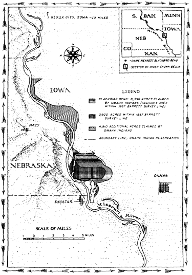
Blackbird Bend And Vicinity
Blackbird Bend is a thumb of land along the Missouri River. Only God knows who owns it; then again, maybe not. If the land could speak, what would it say? That once it was inhabited by the Omaha Indians. Then the Missouri changed course and land that had been west of the river ended up on the eastern bank, several thousand acres gone from the Indians' Nebraska reservation. Sometime early in the twentieth century it came into the hands of white owners in Iowa. Tiring of white ownership, however, the Indians decided to reclaim the land in 1973. About twenty of them trudged to Blackbird Bend in sneakers and blue jeans at about the time the Lakota, not too far away, were winding up their occupation at Wounded Knee. But no one remembers Blackbird Bend, except the Omaha Indians, of course. In 1975, the Indians occupied the land for a second time. Then the lawsuits began, a decade and a half of court appearances, motions, briefs, trial, and appeal. And still the most difficult question you can ask anyone along this brief stretch of Missouri Valley is only four words long: Who owns Blackbird Bend?
This question only matters to a culture determined to own nature, a culture of property. What I mean by this phrase is, very simply, a society that organizes its relations with the world, the natural world in particular, around the concept of ownership. Such a culture is so dedicated to control, so obsessed with possession, that it is willing to deny the complexities of nature to satisfy its craving to own. It is a culture lost in a fantasy world, a society that has long dealt with nature through the American dream of property ownership.
One of the greatest changes that ever took place in North America began with the arrival of the concept of private property sometime in the seventeenth century. Since that
time, Americans have pushed their way across the continent on a mission of conquest, leaving millions of miles of fences trailing across the land—stone walls, wooden railings, barbed wire—with one main message to deliver: It is mine, not thine, so keep out. But every once in a while there comes a piece of earth that just will not fit neatly into the square hole of property. As we peer into that hole and study the history of Blackbird Bend, we are bound to learn something about a culture that can control nature, yes, but cannot control itself—one just desperate to own every last acre there is to be owned.
BLACKBIRD BEND takes its name from Chief Blackbird. He along with the rest of the Omaha Indians hunted there and across a huge expanse between the Platte and Big Sioux rivers. They moved into that area, it is believed, sometime in the seventeenth century. In the summer of 1804, Lewis and Clark ventured through the region. The explorers journeyed up the Missouri River, and when they arrived it was too late to meet Blackbird, who had died in a smallpox epidemic. According to Lewis and Clark, the Omaha "rove principally," which is to say that they hunted game such as buffalo, deer, and beaver. They also cultivated corn, beans, and melons. As far as the explorers could tell, the Omaha had "no idea of exclusive possession of soil."[1] That was to change soon enough.
It was the Omaha's supreme misfortune to be occupying prime agricultural land, property that white settlers yearned to have and to own. Through a series of treaties, the Omaha were gradually dispossessed of their land on the Great Plains. In 1820, the Indians gave up a small parcel so that the government could build a military post. Ten years later, they ceded control over land east of the Mis-
souri—what is now Iowa—in return for annuities. Another ten years and the annuities ran out.[2] In 1854, broke and weakened by attacks carried out by neighboring Indians, the Omaha came to Washington to sign yet another treaty. This one transferred rights to a huge expanse of land west of the Missouri, about thirty-eight million acres in all. In return the Omaha were allowed to keep a small parcel for a reservation.[3]
The boundary lines laid out in the treaties hardly mattered to the Omaha, at least not in the way that they did for the whites, who swore by the line. Even after the Omaha ceded land to the government in the 1830s, they continued to roam through the region in search of buffalo and other game, transgressing precisely the same lines they had agreed to on paper.[4] When referring to the land, the whites spoke about meridians, parallels, and other landmarks. Only a culture dedicated to owning the land exclusively would use such a language, one that the Omaha were just then learning to speak. With the treaty of 1854, the Omaha were running out of land to cede. Three hundred thousand acres including the land at Blackbird Bend was all that was left of the Indians' once magnificent territory. Surrounded by white people and their lines, they were expected to stay put even if the lines themselves did not. Those boundaries had a way of changing every now and then, especially the reservation's eastern one, which the 1854 treaty designated as the Missouri River.[5]
Exactly how the Omaha Indians felt about private property we may never know. But if the Omaha were to participate fully in the culture of property, they needed to own land. Only the 1854 treaty did not make the Indians landowners; it simply provided for the survey and allotment of the reservation into individual parcels. If the U.S. govern-
ment chose to do so, it could remove the Omaha from their land, force them off to some more distant and perhaps less congenial place. No deed or other paper said anything to the contrary.
Then in 1882, Congress passed the Omaha Allotment Act. The act gave the head of each household one hundred sixty acres to be held in trust for twenty-five years, after which time the Indians would be issued a patent declaring them the owners.[6] It was a bill designed to educate the Omaha in the culture of property, providing more than a generation's time for them to learn the ways of that culture.
No one played a bigger role in this education than a Boston anthropologist named Alice Fletcher. In 1881, just five years after George Armstrong Custer and his men were massacred at Little Bighorn, Fletcher bravely journeyed out to the plains to study the Omaha. Fearless and determined, Fletcher was also evidently quite convincing when she chose to be. One colleague had this to say about her: "Some of her opponents never were quite sure what quiet, deep river had just drifted along and left them stranded far from their selfish hopes." Another observer offered this less charitable remark: She was a "dreadfully opinionated woman."[7]
Fletcher was in her forties when she went to the plains. When she arrived, she discovered that the Omaha Indians, quite unlike the white settlers she knew, considered themselves to be "a part of nature." The Indian felt deep down, she believed, that "no aspect of nature is clearly defined from his own life." It was a far less arrogant stance toward the natural world than that of the whites. It was also a philosophy that Fletcher was willing to do just about anything to change. Such a view of nature, she remarked, "is not conducive to . . . holding land as property, of placing a money
value upon it, and passing it from one buyer to another as one would a garment." Indeed, since the Indians believed that everyone depended on the earth to survive, they wondered, according to Fletcher, how "one person [could] own land to the exclusion of other men." They did not wonder long. Because in Fletcher's opinion there was only one way for the Indians to succeed in the world—the white person's world, that is—and that was for them to embrace private property. So she shepherded the allotment act through Congress; then she personally educated the Omaha in the law of property so they too could become landowners and get on with the conquest of the continent. "Our laws of property and legal descent . . . ," she wrote tellingly, "were difficult to make clear to the comprehension of the people, owing to ancient tribal customs."[8]
Finally the day Fletcher was waiting for arrived. Early in the twentieth century, after the trust period ended, patents were issued giving the Indians title to the land. Now they were landowners, free to do what they wished with their property. For many, the first thing they did was put it up for sale. They had to in order to pay the debts they had accumulated and in some instances been tricked to embrace. When Fletcher revisited the Omaha in 1910, even she admitted the allotment act's failure, although she saw it more as a temporary setback, an inevitable adjustment to the equally inevitable world of property. In 1930, one of the most famous anthropologists ever, Margaret Mead, paid the Omaha a visit. Granting the Omaha fee patents, she later wrote, "exposed them to every type of attack by the land sharks who were assembling on all sides."[9] By the thirties, two-thirds of the land allotted to the Omaha had ended up in the hands of white owners.[10]
Gone too by that time was the land at Blackbird Bend.
The white man took it, just as he had the rest of the land, but not through some scheme or fraud. No shady-eyed brokers wheeling and dealing. The land at Blackbird Bend was gone all right. Several thousand acres vanished from the Omaha's Nebraska reservation and reemerged across the way in Iowa where white farmers were more than happy to have it. And claim it they did.
How did several thousand acres of Indian land disappear? The answer to that question can be found hundreds of miles northwest of Blackbird Bend in the town of Three Forks, Montana. That is where the Missouri River begins. From there it travels nearly one thousand miles, working its way through the Montana plains, picking up the Teton, Marias, Judith, Musselshell, and Milk rivers, before reaching a size that is likely to impress the wayward traveler. Then the mighty Yellowstone empties its full force into the river, carrying tons and tons of silt that it gathered up while coursing through the barren foothills of Wyoming. In North Dakota, the Missouri begins to angle south. Its waters swell even more as the Little Missouri, Heart, Cannonball, Grand, Moreau, Cheyenne, White, Niobrara, and Big Sioux rivers tumble in. By the time it reaches Blackbird Bend, if not before, the river has earned itself a name: the Big Muddy. The Omaha call it Ni-shu-da, or Smoky Waters.
The Missouri is the longest river in the United States. And it travels an unpredictable course as it etches its way through a watershed composed of loose, alluvial soil, the kind that at places crumbles like brown sugar into the river. With no solid land or rock to confine it, the river is always on the move, threading its way back and forth through a valley that is at points ten miles wide from bluff to bluff. Throughout its long history, the river has been everywhere in this huge valley. But there is also another reason the Mis-
souri is so ready to shift course. This serpent of a river carries a huge amount of sediment that comes pouring off the arid, barren plains. It transports so much sediment that the writer George Fitch remarked in 1907, "Throw a man into the Missouri and he will not often drown. It is more likely that he will break his leg."[11] To handle all the material washed into it, the Missouri flows sinuously, since it can carry more sediment that way than by charting a straight course. Coiling back and forth across the land, the Missouri loops downstream, struggling to contain all the residuum of the Great Plains. At Blackbird Bend the sediment load has reached as high as three hundred acre-feet per day. In other words, on a daily basis, three hundred acres of soil one foot deep pass by this bend in the river—enough for a small farm. And the river swings across the plains, ready to move in whichever direction it must to deliver this load downstream.
So it is not hard to imagine the Missouri making off with Blackbird Bend. If the river—the reservation's eastern boundary—shifted a mile or so to the west, it would cut straight through the Omaha reservation. Alternatively, the Missouri could have just as easily swallowed up the land a little at a time, depositing it on the Iowa side. Either way, the Indians would lose. And as so often happened, the Indians' loss was the white man's gain—one man, Joe Kirk, in particular.
If it is hard to say exactly how the Omaha lost their land at Blackbird Bend—and the story, we shall see, is not a simple one—there is no question that by about 1916, Kirk had gained possession. Kirk came from Tennessee, by way of Kansas, and settled in the Blackbird Bend area around 1911. By the twenties, he had built a log cabin on the land, and there are some old black-and-white photographs to
prove it. Another photograph shows a group of people posing in a watermelon patch that Kirk had planted out on the property. But mostly Kirk used the land to grow alfalfa to feed his livestock. During the depression, he rented it to tenants who cleared and farmed small portions.
To improve the value of the land, Kirk built levees during the thirties to help fend off the wandering Missouri. He also had some help from the U.S. government. By 1943, having tired of the Missouri's tendency to inundate the region, the Corps of Engineers and the Bureau of Reclamation—the two federal agencies in the dam-building business—set forth plans to control the waters of the valley. Unable to decide which plan to approve, Congress bested itself and adopted both projects. Lewis Pick, chief of the regional office in Omaha, was the author of the corps' plan. He summed up his main philosophy in one simple directive: "I want control of the Missouri River!"[12] Control is precisely what he got. In 1919, there were at least eighteen dams in the Missouri valley able to impound a total of a little more than one and a half million acre-feet of water. By 1974, there were one hundred sixteen dams; together they had the capacity to control over eighty-eight million acre-feet. That is more than twenty-eight trillion gallons of water, enough water to flood the entire nation of Poland to a depth of one foot. The biggest of these dams were built on the main stem of the river, huge structures hundreds of feet high. The dams flooded so much land that nine hundred Indian families in the Dakotas were forced from their homes.[13] But for white owners like Kirk, the dam building had a far more salutary effect. The dams, combined with the hundreds of miles of levees built by the government, stabilized their property, turning Blackbird Bend into a prime piece of real estate.
In 1948, Kirk and his wife, Bertha, put their land at Blackbird Bend up for sale. A good many lives became tied up in the property thereafter. The Kirks sold to Henry and Raymond Peterson, the Petersons to Messrs. Pace and Bookstrom, who in 1959 sold to Charles Lakin, a wealthy farm operator and land speculator. Living disproof of the old adage about death and taxes, Lakin managed to escape paying any property tax on the land until 1969, when the state of Iowa finally discovered the parcel and put it on the tax rolls. In 1972, Lakin sold to Roy Tibbals Wilson, who was in the cash register business and had learned about the property while traveling through the area. And cash register is an apt metaphor for how Wilson saw the property. He bought it to rent out to tenants at a profit. There was only one problem with this plan: The Indians said Wilson did not own the land.
IN APRIL 1973, the Omaha Indians headed off to Wilson's land to reconquer it for their people. More than a hundred years had passed since the Omaha had settled on the reservation, and it looked as beautiful as it always had, still a world of rolling hills, green and brown shading off toward the horizon. But a closer look revealed signs of suffering: old and sagging farmhouses, shingles falling off, brokendown Fords, population and average income in 1970 exactly the same number: sixteen hundred.[14] Escaping this troubled world, the Indians arrived at Blackbird Bend. By the time they got there, Wilson had retired somewhere in Florida, having long since rented out the property to be farmed. The Indians pitched a fifteen-foot tepee and two tents. They brought along a tractor for picking corn and a big pile of wood to ward off the chill of night out on the plains. They also carried with them one other thing: a large framed copy
of their 1854 treaty with the U.S. government. The document, so the Indians said, proved their claim to the property.[15] As far as the occupation went, there was none of the spectacle of Wounded Knee. None of the bloodshed either, although the manager of Wilson's land claimed that he was chased off and later told he would be shot if he returned. No hostages, FBI agents, or federal marshals. Just twentysome Indians trying to reclaim what they believed to be rightfully theirs.
Their leader was Eddie Cline. Cline came from a long line of leaders. Both grandfathers and his father served on the Omaha Tribal Council, the tribe's governing body, and so did Cline himself at various times in his life. He first recalled seeing Blackbird Bend while traveling on horseback as a child. But not until 1962 did he discover from old records and maps that Blackbird Bend belonged to him and his people. "The U.S. government laid down on the law," Cline later said. "As far as the tribe is concerned, the U.S. government as a guardian of our lands let this property get away from us."[16] So when the government failed to act, Cline decided to take matters into his own hands. By the time of the occupation, he was in his forties, and he was acting on his own authority since he no longer served on the tribal council. While Cline and his followers were on the land, they fished, cut down a fence, and dug up a drainage pipe to block access to the area. A month later, Cline was arrested. He was charged with stealing corn from the property. The charges were later dropped, but an injunction keeping the Indians off the land was issued.
History repeated itself two years later when Cline and the Indians returned to the property.[17] Not long before, Cline had been reelected to the tribal council. That mattered because the injunction had been based on his not representing
the tribe in an official capacity. "That was all Indian land over there," said Clifford Wolfe, Sr., a member of the tribal council, sometime later. "We think about our children and our grandchildren. From the income, maybe they'll feel like we're people. Maybe it'll help their schooling, give them something to fall back on. We want that back. Any way we can get it back, we want it back."[18]
The U.S. government, convinced of the legitimacy of their claim, was willing to help the Indians. With Cline and others still in possession of the land, it filed a suit on behalf of the Omaha claiming title to twenty-two hundred acres at Blackbird Bend. So that the Indians could remain on the property while the suit went forward, the government moved for a preliminary injunction to keep the white owners off. It was a clever idea. With the Indians in possession, the government argued that such an injunction maintained the status quo ante, however brief it might have been. And best of all for the Indians, the strategy worked.
For decades the only Indians allowed on Blackbird Bend were the ones sent out there to work it for the benefit of its white owners. Now the Indians were back in possession of the elusive property, at least for the moment. They farmed the land and put the proceeds in an escrow account pending the outcome of the lawsuit. The account built up but not at a rate that satisfied the land's former owners. Blackbird Bend was prime agricultural land, some of the most fertile soil in the country. There could be only one explanation, reasoned the white owners, for the land's present poor performance: the Indians just did not know how to farm it. Otis Peterson, once a tenant farmer at Blackbird Bend, now stood by and observed the Indians who had put him off the property. From what he could tell, the Indians were doing a poor job: "I can only say that the crop of weeds will be
excellent."[19] The conclusion to be derived was clear: What they could not properly farm, they could not properly possess, or so the white owners told the judge.
If the argument sounds familiar, it is because it has been used for centuries to justify the culture of property. Travel back in time to the seventeenth century and you will find that the New England colonists, for example, tapped it to deprive the Indians of their land. Either improve the land or lose it, went the logic there. Or as the minister John Cotton once put it, "In a vacant soyle hee that taketh possession of it, and bestoweth culture and husbandry upon it, his Right it is."[20] It was a long way from the world of John Cotton to that of Wilson and the others out on the Iowa plains. Yet such a philosophy still held a good deal of credence nearly four centuries later. Only in this case, there was little doubt that the Omaha were improving the land, though admittedly not as fast as the whites would have liked. So the judge in the Blackbird Bend matter refused to return the property to the whites.
It was a move Harold Sorenson just could not believe. Sorenson's parents came from Denmark all the way to Miller, South Dakota, to bust the sod and plant flax. In 1939, Sorenson and his wife, Luea, moved from there to Onawa and purchased about a hundred acres.[21] Blackbird Bend was still littered with brush and cottonwoods in those days, and Sorenson and his family cleared it by hand. Later on, when he first heard about the Indians and their land dilemma, he sympathized. He signed a petition saying they should be given back their land. He allowed them to cross his property—tepee, tents, framed treaty, and all—on their way to occupy Blackbird Bend in 1973. Then he learned that some of his own land might be Indian property. He closed the road that the Indians had been using. "I think
that ruling is the most unbelievable part of the whole deal," Sorenson said about the judge's decision to let the Indians remain in possession. "It was like me coming up to you and saying, 'I own your house,' and then having a judge say I can go ahead and move in while we settle who owns it. Isn't that a mess?"[22] It was an interesting analogy, in part because it highlights one of the guiding principles of the culture of property in contemporary America, that nature and houses are equally ownable. Put up some fences and no trespassing signs and the land is as much yours as the twostory farmhouse that you build on it.
Is private property as rock solid as Sorenson's remark suggests? An answer can be found in the struggle that developed over this peripatetic piece of land. After the government filed its case, the Indians, believing that the government had failed to adequately pursue their cause, hired a lawyer and launched some lawsuits of their own. The most important of these alleged title to more than sixty-three hundred acres at Blackbird Bend—over four thousand more than the U.S. government claimed—as well as additional land upstream from Onawa. All told, the Indians claimed title to over eleven thousand acres, plus fifty million dollars in damages. By the late seventies, the Omaha, who had once controlled a sprawling expanse of land on the northern Great Plains, now owned a mere twelve thousand acres. Success in their lawsuit would nearly double the tribe's land base. But reclaiming Blackbird Bend meant more than just land and money. Somewhere in that land the Indians hoped to recover not just soil and water but the very identity of the Omaha people. "Without land we're not a people, and we're not people without land," explained Doran Morris, whose great-grandfather Yellow Smoke had signed the 1854 treaty.[23] Willard Phillips, an Omaha leader, put it this way:
"A man put out a book that says 'Know your roots.' That's what I say. If you don't know your lifeline you ain't nobody. And that's what I want for my kids."[24] That and a few thousand acres of land across the river in Iowa.
Eleven thousand acres of land might not sound like that much to ask for. But for Vincent Willey, an Iowa farmer whose family had been on land now claimed by the Indians for some four generations, it was not the land so much as the principle that mattered most. "If my dad killed somebody, if my granddaddy killed an Indian, does that mean I have to pay for it? Sure there are some things not to be proud of. Naturally we took the whole country from 'em. But are we all gonna pack up and go back where we came from?" Look into the eyes of any of the white owners in Iowa and you would find an answer to that question. Willey only worried about what would happen if they lost. "Some of 'em," he said, referring to the other Iowa landowners, "you'd carry off in coffins."[25]
ONCE A HUGE COTTONWOOD TREE over four feet in diameter stood at Blackbird Bend. When cut down in the 1970s, it was said to be sixty-seven years old. The cottonwood is commonly found in this region, and the Omaha once used it to make the Sacred Pole, a symbol of tribal identity associated with buffalo hunting. With the decline of the buffalo in the 1870s, the Sacred Pole disappeared from the tribe's ceremonial life, the last one carried off in 1888 to Harvard's Peabody Museum to bear testament to a fallen culture.[26] Meanwhile, white settlers on the plains had found a new use for the cottonwood. The Timber Culture Act of 1873 gave title to one hundred sixty acres to settlers who planted trees on forty of them. Since the cottonwood grew fast and needed little care, it was a favored tree in this en-
terprise; William Least Heat-Moon recently called it "the mortgage tree" for this reason.[27]
The cottonwood grew closer to the world of property and real estate when the Omaha decided to stake their claim to Blackbird Bend on it. To see why the Indians chose to do so, we ourselves must delve further into that world to explore how it handles the dilemmas imposed by the chaos of nature.
Lawyers turn out to be excellent accountants as well; they have rules for deciding what should happen when water adds or subtracts from a piece of real estate. Foremost among these is the rule of accretion. It says that soil that accumulates gradually and imperceptibly along rivers, lakes, and seas is the property of the adjacent owner. Property boundaries shift outward with the addition of new land. The rule has roots in Roman times, but it was most clearly articulated in Britain. Small additions of land are of no use to anyone but the adjoining owner, a British case from 1828 explains. So the custom was to allow title to such inconsequential amounts of property to change hands. "Much land which would remain for years, perhaps for ever, barren," the case reads, "is in consequence of this custom rendered productive."[28]
Perhaps the rule made sense in a place like England where additions to land bordering water were nominal (mostly because rivers meandered only modest amounts there and more often flowed in beds made of solid rock). Venture across the Atlantic to the similar terrain of New England and still there was little to object to in the rule. But would the doctrine of accretion apply as it headed west to tackle the tumultuous world of the Missouri? No less an authority than the U.S. Supreme Court said that it would hold there as well. "All lands should have an owner," the court
wrote in 1890, and accretion served this end admirably.[29] Of course, the quantity of land involved in this part of the world could amount to hundreds, even thousands, of acres.[30] Not only that, in the twentieth century, courts in the Missouri valley have applied the rule to man-made changes, so long as the landowner himself was not chiefly responsible for creating the new soil.[31]
Accretion seeks to maximize the productive value of nature. Let the natural world change and property boundaries too would shift to take advantage of nature's new potential. But suppose the change is not gradual and imperceptible, the standard for proving accretion. Suppose instead that a river makes a sudden and noticeable departure. The law has a remedy for this situation as well, the rule of avulsion. This rule also tries to capitalize on nature's economic potential. Should there be a sudden and presumably massive shift in natural conditions, no landowner could feel secure in his property unless the law enforced the status quo ante. Avulsion is set up to do precisely that. It is a rule that favors the past, the way things were before nature disrupted the property. And in keeping with that reasoning, ownership of the displaced land does not change hands.[32]
Accretion and avulsion are static legal categories for describing what should happen when nature intrudes on the world of property relations. They are neat and ideal stories that the law tells about the natural world. Yet neither story, of course, can remotely capture all the complexities of river movement on the Great Plains. Neither is nuanced or sophisticated enough to render legible and clear the dynamic world of nature. Neither has the precision or power for reading a natural world that is messy and unable at times to be read. But these stories would be told there on the plains nonetheless.
The Blackbird Bend trial opened at a little after one o'clock on November 1, 1976, Judge Bogue presiding. Andrew Wendell Bogue was fifty-seven when the trial started and an old man before the matter was anywhere near resolution. He had been scheduled to try the Indians accused of murdering two FBI agents at Wounded Knee. Instead, he was handed the Blackbird Bend case.[33] The trial itself lasted a little more than one month and involved extensive testimony as well as a field trip—Bogue with a group of lawyers in tow all tramping out to Blackbird Bend for a look. The trial transcript fills twenty-one volumes and runs to exactly 3,214 pages. So many papers were filed in the case that an entire room in the Sioux City courthouse is devoted to the matter. Of Judge Bogue, one lawyer asked to evaluate his honor's judicial temperament wrote simply, "Great man."[34] He had to be to endure this case, one that refused to go away, that stuck to his docket like Blackbird Bend mud to his shoes.
William Veeder was the lawyer for the Omaha. He once described himself as "basically a conservative person," although few people today would agree.[35] In his opinion, the Omaha's troubles began on March 5, 1496, not one day before or after. On that day, Henry VII, King of England, commissioned John Cabot to go in search of "provinces or regions hitherto unseen by Christian people." What Cabot started, Lewis and Clark plus a stream of white settlers, now lost to history, finished. The result was clear to Veeder: "Genesis of the present grave problem of the Omaha Indian Nation and the Indian people comprising that Nation, can be attributed directly to avidity to occupy, without right, the lands of the Indians."[36]
The trial concerned about twenty-nine hundred acres. That number represented the amount of land within what
was called the Barrett Survey, after Theodore H. Barrett who marked the easternmost limit of the Omaha reservation back in 1867. His line was the only solid one to be found in the chaos of land and water that was Blackbird Bend. All the remaining property claimed by the Indians would be dealt with later.
About this land Veeder had much to say. But for him and the others gathered in Judge Bogue's courtroom, only one thing mattered. Who owned Blackbird Bend would depend on how the Missouri River behaved in the time since the Omaha were granted their reservation in 1854. In other words, title to the property rested on the history—complex though it was—of land and water at Blackbird Bend.
The only Indian to testify at the trial was Eddie Cline.[37] He explained how the Omaha had gone about occupying the land, but he had little knowledge about the Missouri's effect on Blackbird Bend, the main issue at the trial. So Veeder had to rely on a number of expert witnesses to make his case. Of these, perhaps the most important was Charles Robinson—geologist, engineer, charter member of the Association for Professional Geological Scientists, and an expert on rivers and sediments. Robinson noted that in 1867, when Barrett first surveyed Blackbird Bend, it was a thumb of land that protruded into the Missouri River. Over the next eight years the thumb grew. As the river entered the bend, water near the surface flowed faster than water at the bottom of the river. Centrifugal force then came into play. It imparted a circular motion such that each particle of water traveled downstream like the thread on the surface of a screw. The result was that water closer to the surface bit into the concave bank eroding it; water lower down took the material and added it to the convex (Nebraska) side of the river.
Slowly the river moved to the east, carrying more and more soil to the Nebraska side. Blackbird Bend grew bigger.[38]
The Indians were profiting, briefly reversing the process started by Cabot, when all of a sudden, sometime between 1875 and 1879, the river moved to the west, cutting them off from the land the government had granted in 1854. According to Robinson, when the river reached a certain point in its eastward migration, it tried to move south but was stopped by a deposit of clay not prone to erosion. So it moved suddenly westward instead. An avulsion took place, in Robinson's words, "a sudden, an abrupt change of a river from one channel to another." And since there is no change of ownership with an avulsion, the land, Veeder argued, still belonged to the Omaha.
For the next three decades, the river migrated slowly to the north and Blackbird Bend once more expanded in size. Then came another avulsion. The only witness the tribe could find to prove it was the lone cottonwood tree mentioned earlier. A little computation explains what happened. Subtract the tree's age of sixty-seven from 1976, the year it was cut down, and you arrive at its date of birth, 1909. Since the tree started growing before 1912—the earliest the river could have suddenly shifted course—and still existed after this time, an avulsion must have taken place, reasoned Veeder. Had the river eroded land by moving slowly to the south, it would have swept the young tree away. But if the river moved suddenly in that direction, it would have left the cottonwood intact—there to bear witness to an avulsive change, to the fact that the land was still Indian property.
The tribe's case came down then to these two sudden periods of river movement. After the 1920s, of course, man-
made influences became more strongly felt at Blackbird Bend, as Veeder and the tribe were well aware. Kirk built levees; the corps constructed dikes and other means of water control. The impact of this work was twofold: it trained the Missouri to stay within a designated channel, and it also caused land to slowly accrete to the Iowa side of the river. As this was happening, Kirk and others moved onto the land and, in Veeder's estimation at least, "got rich on it."
Veeder and the tribe had one story to tell about Blackbird Bend; the white owners, of course, had another. Lawyers for Wilson and the other defendants went in search of a witness with enough authority to refute the tribes' claims, someone who would weave an entirely different tale about this embattled piece of property. In Raymond Huber they found their man. It took a good part of a morning for Huber to set forth his credentials to the court. Born in Kansas City, Missouri, in 1907, Huber had gone to work for the Corps of Engineers at age eighteen. He had been trained as a civil engineer. For almost four decades, Huber devoted his life to one thing: the control of nature. The corps put him in charge of stabilizing the Missouri's channel all the way from Rulo, Nebraska, in the state's southeastern corner, to Three Forks, Montana. By his own account, he visited Blackbird Bend no less than three hundred times, by boat, car, and plane and on foot. When he finally retired in 1963, Huber was awarded one of the corps' highest honors: the Meritorious Award for Outstanding Civilian Service. ("This award," he told the court, "consists of a medal which I can attach to ribbon, which I can wear around my neck, and also a pin for the lapel.")
Did he have an opinion about what happened at Blackbird Bend between 1855 and 1890? Yes, he did. It "gradually eroded westward, and as it did erode westward depo-
sition in the form of sand and accretion was formed" on the Iowa side.
Did he have an opinion about the period from 1906 to 1923 (little evidence existed for the intervening time)? Yes. The river eroded the reservation, "and deposition occurred to the east, Iowa shore."
Was there any evidence of avulsion between 1923 and 1940? None.
Could any of the structures the corps used to control the river have caused an avulsion to take place? "No, sir."
It was not that Huber's view of what happened at Blackbird Bend was in its details all that different from the tribe's story. Both sides, after all, were using largely the same evidence—mostly maps and surveys—to reach their conclusions. What was different was Huber's—and the defense's—understanding of avulsion. As Huber understood the word, it involved the transfer of a "piece of land from one bank of the river to the other" such "that you can follow the movement of that transfer of land and identify it as the identical land which formerly existed on the other bank, beyond any power of question." Now that was an exceedingly narrow definition of the term, far narrower than the one offered by Robinson and the tribe ("a sudden, an abrupt change of a river from one channel to another"). Using such a strict standard, one could argue, precisely as the defense did, that no avulsion whatsoever had taken place.
Not only had no avulsion taken place but, according to the defense, the tribe's own people supported that conclusion. They pointed to a series of letters written between 1906 and 1917, roughly the time when the tribe postulated an avulsion. The letters were indeed written on behalf of the Omaha people, Indians who found that their allotted lands were being destroyed by the Missouri River and who were
asking the U.S. government for a new piece of property. Dora Pappan, for example, found that of the forty acres of corn her son-in-law planted near the Missouri, only six were left, "the remainder having been washed away." There was no mention made of any sudden, avulsive shift, just water slowly eroding the land.
If any of the Indians mentioned in the letters were still alive, not a single one came forth to testify at the trial. The closest either side in the case came to an eyewitness of river movement was George W. Prichard. He was eighty-two when he took the stand and had lived in Onawa for the last three-quarters of a century. In his younger years, Prichard and his father often set off with a pack of hounds to hunt cows and rabbits near Blackbird Bend. "Particularly cows. My father liked to chase them." In the summer of 1919, about the time of the avulsion asserted by the tribe, Prichard met Joe Kirk, saddled up some horses, and headed out to the area. All morning they rode, Kirk telling him his plans for the newly created property. Did Prichard see any indication of land cut off from the Nebraska side of the river while out there? No. Was there any indication of land other than new land that had slowly accreted to the Iowa side? None.
More witnesses were called than there is space to tell here. Then on December 6, 1976, the trial finally ended. In many ways, the history of what happened at Blackbird Bend remained as complex, muddled, and inconclusive as ever. History, one scholar has lately observed, is "a series of messes."[39] It certainly looked that way at Blackbird Bend.
Bogue pondered the evidence for six months before issuing his ruling. "During the period from 1854 until at least
the early 1940s," he wrote in an introduction to the opinion, "the Missouri River can best be described as in a wild and uncontrolled state."[40] To a people obsessed with the control of nature, those may well have seemed like sensible words. But it is just as easily argued that what is wild is the effort to pour tens of thousands of tons of concrete and steel into keeping the river from charting its own course toward the sea. The control of nature is one thing; but the nature of control, to turn things around, is that it has limits.
Bogue then went on to give a detailed analysis of river movement between 1855 and 1940. Everywhere he looked he saw accretion. He dismissed the sixty-seven-year-old cottonwood, holding that the tribe rested its case that the tree proved avulsion on questionable assumptions about where the river had actually been at different times in the past. He found fault with the credentials of the tribe's experts (one, a surveyor, he pointed out, was "neither a geologist nor a hydrologist"). Certainly none of the tribe's experts could possibly match Huber's thirty-seven-year record on the Missouri. He also thought it "somewhat strange" that the river would move east and north by accretion and in the opposite directions "by a 'jumping action' so as to qualify in the eyes of the law as an avulsion."[41] And most important, Bogue rejected the tribe's understanding of avulsion. Instead, he opted for the narrower definition offered by the defense, that identifiable "land in place" needed to be shown to prove it. That definition virtually guaranteed that Bogue would find accretion—a ruling, it must be said, that favored society's possessors, particularly those with land along the river who stood to benefit from the slow addition of new soil. So impressed was Bogue with the defense's theories that when he sat down to write his thirty-
five-page opinion, he took all but six of those pages directly from a pleading filed by the defendants themselves—verbatim.
"We thought all along he would rule against us," said Eddie Cline afterward. "I guess the only surprise was that he really had the audacity to follow through and do it."[42] So Cline and the others refused to budge from Blackbird Bend. Three times in May 1977 the county sheriff and his deputies came out to the property to put the Omaha off. Three times they were turned away.[43] The Omaha had a sign up at the edge of the land. It said
BOUNDARY LINE
OMAHA INDIAN RESERVATION
NO TRESPASSING
They meant it.
On May 13, 1977, just as the Indians were being offered one last chance to leave, a messenger arrived. He brought word that a federal appeals court said the Omaha could stay until it ruled on Bogue's decision.[44] Almost one year later, the appeals court overruled Bogue.[45] It pointed to an old federal law that said that in a trial over property between an Indian and a white person, the burden of proof rests on the white so long as the Indian can demonstrate "a presumption of title in himself from the fact of previous possession or ownership."[46] Such a presumption was simple enough for the Omaha to prove; all anyone need do was look at the 1854 treaty. The ruling increased the burden of proof on the defendants. Meanwhile, the court also made it easier for the tribe to prove an avulsion by broadening Bogue's definition of that term. An avulsion, the court explained, involved "a sudden perceptible shift of the channel." The
case law said so, precisely as the tribe had argued. "We hold the evidence too conjectural and the ultimate conclusion reached too speculative to sustain the defendants' burden of proof," concluded the court.[47] Title to twenty-two hundred acres, the court ordered, belonged to the tribe. But a small fraction of all the land the Omaha claimed, it was something nonetheless.
For more than a decade, the case moved up and down through the federal court system on appeal until a decision was finally reached on who owned the remaining seven hundred acres at Blackbird Bend. Although the reasoning need not detain us, title came to rest with the non-Indian owners. And the same held for all the remaining land—some eight thousand additional acres—claimed by the Omaha on the Iowa side of the river.[48] "The Indians want everything the Missouri River ever touched," said Don Ruth, an Iowa landowner, "but that just isn't the way it is."[49]
The court of appeals' 1978 ruling cost Harold Sorenson some land at Blackbird Bend but not nearly as much as Roy Tibbals Wilson, who said good-bye to more than one thousand acres. Wilson was understandably upset. "Why wouldn't I be upset?" he told one reporter after the decision. "It wasn't the right ruling. It's like somebody coming to my house and saying, 'You get out of here because we're going to take over.'"[50]
ON THE LAND that once belonged to Wilson and others, the Omaha have decided to build a gambling casino—thirty thousand square feet of blackjack, poker, and dice. The property seems well situated for such pursuits. Doran Morris, now tribal chairman, explains that in building the casino, the Omaha are trying to forget the past problems that arose over Blackbird Bend. "That was yesterday, now we're
going on," he explains. "Now we need employment, my people are poor. And this is how we will do it."[51] Some, like Harold Sorenson, find it difficult to forgive and forget. Sorenson refuses to give the casino his business. "I can just see some night a guy in a big Cadillac with Kansas City plates rolls in here and wants to know where the casino is."[52]
Sorenson, like Wilson, had compared the loss of land at Blackbird Bend to the taking of his house. How did both men come to imagine the land in this way? In part, of course, it has something to do with the assumptions of a culture that by this point in the twentieth century had grown used to having its way with the natural world. Blackbird Bend exists today, if it exists at all, because of the technological domination of nature, transformed by the Corps of Engineers, among others, into a thing that can be owned. Moreover, this aggressive stance toward nature has been incorporated into the language of property. Consider the thoughts of Jeremy Waldron, who teaches law at the University of California at Berkeley, some seventeen hundred miles away from Blackbird Bend. "In a system of private property," he wrote recently, "the rules governing access to and control of material resources are organized around the idea that resources are on the whole separate objects each assigned and therefore belonging to some particular individual."[53] By implication, nature under such a system is a resource, a simple utility destined to be controlled and manipulated to serve largely economic ends. And like all other resources in the private property system, nature must also be divided up and treated as a set of "separate objects" or things. The culture of property strives to imagine the natural world in such a way so as to control, dominate, and own it. Nature is thus broken apart so it can be put back together as individual pieces of property. But things were not so sim-
pie at Blackbird Bend, where the river fought back and reassigned property rights.[54]
To imagine Blackbird Bend as a thing—such as a house—is to picture it in isolation from the world. It is in some sense to lie, to hide from view the social and ecological relations of owning land in this place. Nobody built Blackbird Bend in the same way one did a house, and nobody can own it in quite the same way either. Yet the house analogy is powerful precisely because it expresses a sense of entitlement while at the same moment obscuring the assumptions on which that entitlement rests. For the white owners to envision the land as a house that they built meant denying that it once belonged to the Omaha. It also involved repressing the role that an uncontrolled Missouri played in delivering the property into the hands of the white people.
If you took Blackbird Bend, overlooked the complexity of the land there, and forgot about the Missouri River and the sound of water washing against soil, you perhaps might end up with a house or some other "separate object." Then put a fence around the property, go inside, and close the door. Now a group of Indians, from another state no less, come knocking at that door, say the land is theirs, sue you, and win. It might well seem to you, as it did to Sorenson and Wilson, that someone had come right into your home and taken it. But what Sorenson and Wilson really lost was something they never had: absolute control over land in a place where control of any sort is hard to fathom.
Property in land is an act of denial, a wish for closure, for solid control and dominion over nature. Perhaps that explains why the law still refers to land as real property, to deny what is unreal, porous, and imaginary about it. Yet as real as property in land may seem, it is still, of course, a legal fiction for imposing rational order on an often uncoop-
erative environment. Property law is the voice of reason that we use to tidy up the messy and dynamic world of nature. But take its rules for ordering nature far enough and you wind up eclipsing that reason altogether.
If you have any doubts, consider the following recent piece of unparalleled logic.
OMAHA (AP)—Zigs and zags of the Missouri River could complicate attempts by a Nebraska Indian tribe to build a casino on tribal land in Iowa, officials said.
The Omaha tribe of Macy wants to build a casino near Onawa, Iowa, about 60 miles north of Omaha.
But changes over the years in the Missouri River channel might have put the Iowa tribal land within Nebraska borders, a deputy Iowa attorney general said.
"The river no longer is necessarily the exact boundary," Sherie Barnett said. "It's a very complex legal squabble over who owns what."
But Barnett also said state officials are confident that the tribe legally possesses land in Iowa.
"Whether we all agree that they own the same piece of land, I don't know," Barnett said. "Hopefully the parcel that the Omahas ultimately choose to place their casino on will be something everyone can agree is actually in Iowa."
If the tribe's land is considered to be in Nebraska, the tribe couldn't negotiate a
casino compact with Iowa, Barnett said. Nebraska law prohibits casino gambling.
"To me, the tribe has a problem," said Thomas R. Burke, an Omaha attorney who has represented Iowa landowners in a court battle with the Omaha tribe that began in the 1970s.
"They must be assuming that the land is in Iowa, just because it's on the Iowa side of the river."[55]