Geographical Patterns of Expansion
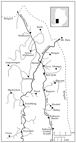
The southern Cordillera's vegetable zone has gradually projected outward in several different salients over the past twenty years. As the road network has been extended, ever more communities have been able to take up commercial farming (see map 8). In the 1960s and 1970s, several projections pushed westward from the Mountain Trail heartland. But further movement to the west is uncertain. In much of Bakun municipality, for example, progress is impeded by steep and rocky slopes and by the locally active New People's Army.

Map 8.
The Road Network of Buguias and Nearby Locales.
Some of the smaller and more recent roads are not indicated.
Note also that the Agno Valley Road north of Kabayan
Barrio is seldom passable during the rainy season.
Northward, the vegetable frontier has recently enveloped several Northern Kankana-ey villages in Mountain Province. Here local residents who had previously labored on Mountain Trail farms introduced commercial production. Yet these communities essentially retain subsistence orientations, with vegetables forming subsidiary cash crops (see Voss 1983). The same is true in several Ifugao villages in the Kiangan region, where vegetable gardens are presently increasing in acreage.
In recent years, the main thrust of expansion has been eastward from the Agno Valley, particularly in Kabayan (Calanog n.d.) and Buguias municipalities. In greater Buguias, development in the 1960s and early 1970s was concentrated in the north. Contractors gradually extended feeder roads east from Lo-o and Bad-ayan into the oak-covered hills. In 1976, however, the main frontier shifted southward after the Buguias-Bot-oan road was inaugurated. Intended as the first leg of a proposed highway into western Ifugao, this route terminated at the then insignificant hamlet of Bot-oan. Within a few years, Bot-oan had become a major agricultural and commercial center, and the seat of the new barangay of Catlubong, carved out of the territory of Buguias proper.
Bot-oan, sitting on the pine-oak border, is ideal for most temperate vegetables. Here a relatively flat saddle is endowed with abundant water and unusually light and friable soil. Yet the local inhabitants had little interest in vegetable culture before the mid-1970s. A few had grown and sold peas, but most still raised swine for their minimal cash needs. Hog raising no longer yielded much profit, however, in large part because hogs could no longer roam free.
The Bot-oan people, considered the least "progressive" of all the residents of greater Buguias, lacked both the knowledge and the capital necessary to exploit the new opportunities the road provided. But several prosperous couples quickly moved up from the Agno Valley to develop the land. Before long, they composed a local elite, whose exogenous origins their poorer neighbors did not forget. Only one local resident ascended into the elite stratum, a rise made possible by many years of work in the Saudi oil fields.
The outside developers first hired workers, both locals and Kalanguya immigrants from Ifugao province, to clear new gardens. But by the 1980s most had turned to bulldozers. Usually they would turn the newly made plots over to local sharecroppers. Many share-
croppers later cleared their own tiny gardens, giving Bot-oan today a mixture of large and small holdings.
Not long after the road arrived, other entrepreneurs opened a number of stores and a periodic market emerged as well. Impetus for retail expansion came from both the growing local economy and from Bot-oan's newly strategic position vis-à-vis western Ifugao. The village now occupied the closest roadhead to Tinoc and Tucucan. By 1985, several hundred Tinoc residents were making the trek to Bot-oan twice each week, returning home the same day heavily laden with goods ranging from rice and gin to treadle sewing machines and iron sheeting.
More profitable than stores are transport vehicles. During the long wet season few trucks can negotiate the steep climb out of the Agno canyon; the three Bot-oan entrepreneurs who own powerful International Harvesters able to make the climb form an effective, if seasonal, transport oligopoly. Nevertheless, Bot-oan retail prices are on average lower than those of Buguias. Buguias residents find this perplexing and infuriating, and most attribute it to the noncompetitive environment of their own increasingly marginal community.
The Bot-oan road has also allowed the Kalanguya people of Tinoc and nearby villages greater participation in the market economy. Tinoc now lies at the far eastern fringe of the vegetable empire, the position previously occupied by Bot-oan itself, where high-value, lightweight crops can be grown profitably. Peas in particular have made inroads into local swiddens. Physiography itself contributes to pea culture, Tinoc being somewhat protected from the typhoon winds that frequently destroy fragile trellises farther west. After a severe storm, Tinoc growers can reap high profits in the inflated pea market. Lately, a few growers have gambled on other crops; by early 1986, young Tinoc men were carrying fifty-kilo sacks of carrots to the Bot-oan market during price peaks. To date, however, seldom are such vegetables valuable enough to bear the cost of portage over the tortuous, muddy, and leech-infested trail linking the two villages.
In southern Buguias and northern Kabayan municipalities, contractors pushed two other feeder roads to the edge of the cloud forest in the 1970s. Here, in contrast to Bot-oan, almost all local residents had been cultivating small commercial plots since the 1940s,
carrying their produce first to Kilometer 73, then to Buguias Central. Road development allowed some to expand their gardens, but most have remained small operators. Outside entrepreneurs have not found these areas attractive, in part because their slopes are steep and their water insufficient. Furthermore, since the locals already had gardens of their own they have been reluctant to accept sharecropping arrangements.