PART ONE
SHERPA CULTURAL ECOLOGY
1
Sherpa Country
The Himalaya rises regally above the subtropical lowlands of the Ganges valley, a vast sweep of mountains crowning the Indian subcontinent with a 2,400-kilometer tiara of the highest peaks on earth.[1] Nepal is its centerpiece. Here the Himalaya crests against the edge of Tibet in a rampart of peaks which average 6,000 meters in height and includes most of the world's highest mountains.[2] From the Tarai, the narrow Nepalese share of the Ganges valley in the south of the country, where the altitude is below 200 meters and the climate subtropical, the highlands ripple toward the Tibetan plateau in a staircase series of ranges. Three parallel ranges sweep northwest to southeast across the country. First come the low foothill ridges of the Siwalik range (also known as the sub-Himalaya and the Churia hills), which rise abruptly from the plains to attain elevations of 1,000-1,800 meters. Just to the north, sometimes so close as to merge with the foothills and otherwise only separated from them by the narrow longitudinal valleys of the Inner Tarai, are the higher ridges of the Lesser Himalaya. Here the crest of the Mahabharat Lekh, the leading edge of the Himalaya proper, sometimes surmounts 3,000 meters in altitude. Beyond it is a 70-110-kilometer-wide band of hill country known in Nepali as the pahar , the hills, and which is often also called the middle hills or the Nepal midlands. This hill country is the geographic, historical, and demographic heartland of Nepal. Here a complex contortion of ridges and valleys extends across most of the breadth of the country to the gleaming snow peaks of the Great Himalaya. To the north, beyond the verdant, terraced slopes of the Nepal midlands, towers the massive upthrust of the Great Himalaya, a crystal wall of snowy
summits which rise with such relief that by comparison the rugged topography of the rest of Nepal seems only low, rolling foothills. In Nepali this high range is called the himal , the mountains, and the word has come to signify a realm distinct from the rest of the country in its height, ruggedness, climate, vegetation, and populace. The main range trends northwest to southeast across the length of Nepal and from it massive high ridges lead perpendicularly to the south into the midlands. These great ridges shape the lie of the midlands' valleys and drainage except where a few major rivers wind longitudinally along a span of the Mahabharat Lekh or the Siwalik range before finding a passage through these final barriers to the plains. In eastern Nepal the Himalaya forms the border with Tibet whereas in western and central Nepal trans-Himalayan or inner-Himalayan valleys lie beyond the Great Himalaya and south of the Tibetan border ranges.[3]
The Great Himalaya attains its greatest heights in central and eastern Nepal around the headwaters of the Dudh Kosi and Barun rivers. Here a vast line of glaciated peaks soars high above the green ridges of the midlands. The range reaches its pinnacle in the country around Mount Everest.[4] Four of the world's fourteen 8,000-meter peaks (app. 1) stand along a 90-kilometer span of the Great Himalaya known as the Mahalangur Himal.<Popup-01-05>5 Three of these, Cho Oyu, Lhotse, and Mount Everest are part of the Khumbu Himal, a wall of great peaks aligned northwest to southeast which also includes Gyachung Kang and Nuptse.[6] In this region the Great Himalaya consists of two parallel ranges, for less than twenty kilometers to the south of the main Mahalangur Himal is the Numbur-Kantega range that includes such famous Khumbu peaks as Kwangde, Tamserku, and Kantega.[7] Still more high mountains punctuate the four ridges that traverse north to south between the two ranges, among them Pumori, Tsola Tse, Tawache, and Khumbila. The scores of big mountains make this the densest concentration of high peaks in the entire vast arc of high country from the Indus to the Brahmaputra.
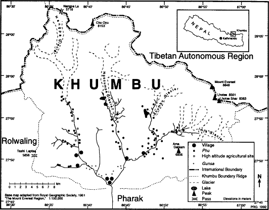
In the midst of this fierce verticality is the country that Sherpas call Khumbu, an 1,100-square-kilometer region bounded on the north by the Khumbu Himal, on the south by the Numbur-Kantega range, and on the east and west by high ridges that link the two and ring the region with a nearly unbroken wall of mountains (map 1). Four high valleys thread between the vertical expanses of rock and ice: the valleys of the Dudh Kosi (the "Milk River") and the Bhote Kosi (the "Tibetan River"), and the two forks of the Imja Khola, the northern Lobuche Khola and the eastern Imja Khola proper.[8] These valleys are the products of the same tectonic forces that raised up the ranges and ridges which flank them and their positions reflect the strikes of prominent faults.[9] They comprise the headwaters of the Dudh Kosi, a tributary of the Sun Kosi and one of the
major rivers of eastern Nepal. The Dudh Kosi is born in the glacial snows and lakes at the foot of Cho Oyu and Gyachung Kang, fed by the melting of the Ngozumpa glacier and the waters of several high lakes. It flows south through the center of Khumbu, picking up first the tributary waters of the Imja Khola, which drains eastern Khumbu, and then those of the Bhote Kosi of western Khumbu before breaching a gap in the Numbur-Kantega range and flowing on into the Nepal midlands.[10] Relief between the floor of the Dudh Kosi valley and its tributaries and the adjacent peaks ranges from 2,000 to 4,000 meters (Vuichard 1986:48).
The upper reaches of all four valleys are wide-floored, U-shaped troughs that testify to the erosive power of ancient glacial advances. At the head of each valley there are still large valley glaciers, and the braided streams of the upper valleys flow cloudy with the silt of the glacial sources. Some of these valley glaciers are more than ten kilometers in length and the eighteen-kilometer-long Ngozumpa is one of the longest in Nepal.[11] From these high sources the Khumbu rivers lilt among alpine meadows before descending into the fir, birch, rhododendron, and juniper subalpine forests which finger up into the valleys as high as 4,000 meters.[12] Below 3,800 meters the river courses steepen and plummet into precipitous river-carved canyons. These narrow gorges are among the deepest in the Himalaya. On their north-facing slopes they are thickly wooded with temperate forests of fir, birch, and rhododendron. The sunnier south- and west-facing slopes are primarily grassland, shrubland, open temperate woodlands of juniper and fir, and settlement areas. In these reaches the Dudh Kosi meets first the Imja Khola and then the Bhote Kosi before storming out of Khumbu and on towards the Ganges through a narrow gorge between the peaks of Tamserku and Kwangde. Only in these lowest reaches of the canyons does the altitude ever dip below 3,000 meters. It reaches its lowest point, Lartsa Doban, at the 2,800-meter confluence of the Dudh Kosi and the Bhote Kosi. Only in these gorges is the altitude low enough for montane pine forests to survive and even then pine is primarily found only on sunny slopes. Most of Khumbu is too high in altitude for any forests whatsoever. More than 95 percent of the region is above 4,000 meters in altitude.
Khumbu climate ranges from temperate to arctic depending on altitude and aspect. In lower Khumbu the climate is generally milder than might be expected at such altitudes. The mean daily temperature in January, the coldest month, is -0.4°C in Nauje (3,440m), while the warmest month mean daily temperature (July) is 12°C. The mean minimum in January in Nauje is -7.9°C (Joshi 1982:399-400).[13] The lack of bitter winter temperatures in lower Khumbu, even at altitudes well above 3,000 meters, reflects the region's relatively low latitude (at 28° north it is farther south than Cairo or New Orleans) and the shielding
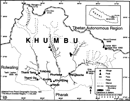
Map 1.
Khumbu
effect of the wall of ridges which encircles Khumbu and shelters it from much of the impact both of the bitter northern, winter winds that sweep the Tibetan plateau and the torrential downpours of the summer monsoon that rake the area just to the south. Khumbu is one of a number of valleys in the Great Himalaya which are similarly situated in partial rain-shadow conditions and which are sometimes referred to as inner Himalayan valleys.[14] The annual precipitation in even the wettest parts of Khumbu is scarcely half of the more than 2,000 millimeters recorded less than ten kilometers to the south. Precipitation is highly seasonal. Nearly 80 percent of annual precipitation falls during the four months (June through September) of the summer southwest monsoon season.[15] Rainfall varies regionally with altitude, local orographic effects, and aspect. Khumbu precipitation generally decreases with altitude and at Lhajung (4,420m, 518mm) is half or less of what Nauje (3,440m, 1,076mm) and Tengboche monastery (3,867m, 1,127mm) receive (Byers 1987b :35; Inoue 1976). Local rain shadow and orographic effects also cause rainfall to vary from valley to valley, even within valleys at sites of similar altitude. This climatic variation is of great importance for the conduct of agriculture and pastoralism. Snowfall is not heavy and below 5,000 meters most precipitation falls as rain. South- and west-facing slopes below 4,000 meters are normally not blanketed with snow for more than a few weeks each winter and most snowfalls melt within three or four days. North- and east-facing slopes retain snow much longer, often for months on end. The relatively low snowfalls of most winters are due in part to Khumbu's easterly location, for at 86° east longitude the region is far enough east to be beyond the reach of the brunt of the westerly winter storms that drop so much snow on the westernmost Himalayan regions. The heavier snowfall of some years, however, poses dangers of avalanche in some areas and jeopardizes yak herds by depriving them of opportunities for browsing senescent grass.[16]
Eight major villages nestle in the lower reaches of the region between 3,400 and 4,000 meters on the rare bits of gentle ground in a largely vertical country. These villages are Nauje, Khumjung, Kunde, Pang-boche, Phurtse, Thami Og, Thami Teng, and Yulajung.[17] Their settlement sites include alluvial terraces, hanging valleys, and amphitheater-like slumps. In population they range from 14 to 135 households in size. Each village is a congregation of one- and two-story white stone houses usually roofed with slate or fir shakes (and occasionally now with corrugated iron). Each house is surrounded by terraced fields. Large expanses of terraces, pastures, and woodlands cloak surrounding slopes beyond the cluster of houses. Many villagers also own fields and herding huts high up in the upper valleys and a few cultivate secondary fields below the main villages on the steep slopes of the lower gorges. The
forests and pastures of the lower valleys and even the high alpine meadows and tundra of the glacial trough upper valleys are sprinkled with scores of secondary settlements that Sherpas use as seasonal bases to maximize their use of the resources of the far corners and diverse micro-environments of the region.
Khumbu is bordered on the north by Tibet and on the west, south, and east by Nepalese regions known as Rolwaling, Pharak, and the Arun river region (map 2). These borders follow very clear topographical lines as well as cultural ones. On the west the border between Khumbu and Rolwaling is a line of peaks and ridges which can be traversed only by the dangerous glacier crossing of the 5,755-meter Tashi Laptsa. Rolwaling is a high valley, environmentally similar to Khumbu in many respects, which was settled in the mid-nineteenth century by Khumbu Sherpa emigrants from the Bhote Kosi valley (Sacherer 1975, 1981). On the south Sherpas consider Khumbu to end at Lartsa Doban, the confluence of the Dudh Kosi and the Bhote Kosi.[18] Farther south is a lower-altitude, wetter country, the Pharak region of the Dudh Kosi valley, inhabited by Sherpas who differ from those of Khumbu in several respects. One of the most evident is their reliance on a rather different system of agropastoralism based on year-round crop production and different varieties of crops and livestock. Just south of Pharak is an area inhabited by Sherpas and Magars and beyond that the lower Dudh Kosi valley and its tributaries are the home of Sherpas, Rais, Gurungs, and Hindu hill castes. In the east the upper Imja Khola valley is walled off from the Barun and the Hongu basin regions by high ridges crossed only by three passes, Amphu Laptsa, Sherpani Col, and Mingbo La (Mingbo Pass), which require technical mountaineering skills to traverse.[19] The upper Barun and Arun country on the far side is inhabited by several peoples who appear to have Tibetan origins as well as by some Sherpa families who migrated here in the nineteenth century from areas south of Khumbu. Rais inhabit the valleys south of the Hongu basin and they and Gurungs from the Ra Khola region farther to the south use some of the high country south of Khumbu for summer pasture. To the north of Khumbu the main crest of the Himalaya forms both a cultural and a topographic border with Tibet. A single pass, the Nangpa La (5,716m), leads north. Seasonally it can be negotiated by yak as well as by foot travellers and the actual crossing is rather gentle, although its crevasses and storms are hazards to be reckoned with. In former times a great deal of trade was carried out over it. From Nauje Sherpa traders can reach the pass in as little as four days with a fully loaded caravan. On the far side lie the rain-shadow plains and arid hills of the Tingri district of Tibet, the vast treeless expanses dotted with the black yak-hair tents of nomadic pastoralists and villages of flat-roofed, courtyard houses. Only
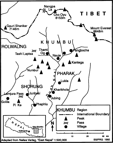
Map 2.
The Solu-Khumbu Region
six days with yak north of the Nangpa La is the village of Ganggar (also known as Tingri), which was a major Sherpa trading center until the late 1960s and where several Khumbu families once owned houses that they used as seasonal trading bases. Just to the east, at the northern foot of Mount Everest, are the ruins of Rumbu (Rongbuk) monastery, once the highest in the world and a place that long has been important to Sherpas (see Ortner 1989:130-131). West of Tingri is Rongshar, a Tibetan valley
used occasionally by Khumbu Sherpas as a secondary, year-round trade route between Tibet and Nepal and where one prominent Khumbu Sherpa trader once owned a large yak herd that was cared for by hired Tibetan herders.
Politically Khumbu is today part of the Solu-Khumbu district. Khumbu forms the northernmost part of the administrative district, an area only slightly more than double the size of Khumbu but whose population is nearly thirty times larger and includes more Rais, Magars, Gurungs, and Hindu hill-caste inhabitants than Sherpas. The district center, Salleri, is a recently developed new town in a Sherpa-inhabited region of Solu (an area Sherpas call Shorung) in the southern part of the district four days walk from Khumbu. Kathmandu is yet more remote and until the 1960s to reach the national capital required two weeks of hard walking and the crossing of six passes. The Chinese-built Arniko highway which was completed during the late 1960s and the Swiss-built Jiri road that was finished in 1985 have now bridged half the distance between Kathmandu and Khumbu and may one day reach still closer.[20] Khumbu today is, however, better integrated with the rest of the country by air than by road. Except during the summer months, when the weather and the condition of dirt airstrips usually force the closing of the airstrips, nineteen-seat Twin Otter aircraft land at the STOL (Short Takeoff and Landing) airstrip at Lukla (a day's walk south of Khumbu in the Pharak region), which was constructed in 1964 by Sir Edmund Hillary. Recently a second STOL airstrip just above Nauje at Shyangboche has become active again. This was built in 1971-2 by a Japanese-led consortium as part of a luxury hotel development. It is only suitable for Pilatus Porter single prop planes that carry a maximum of seven passengers.[21]
Sherpas have their own geography of Khumbu, one much richer than that of outsiders in its intimate familiarity with every corner of the region. The Sherpa conceptual map of Khumbu is far more complex than even the finest Western maps. Western maps name little more than a few of the outstanding topographic features and settlements, often with names borrowed from Sherpa usage but so garbled in the process that the most recent editions of the best foreign maps continue to mistake the names of important herding settlements and landscape features. The Sherpa geography of the area recognizes another level of features altogether, naming a multitude of pastures, forest areas, tributary valleys, slope regions, and settlements that do not appear on any foreign maps. The awareness of local geography reflected by place names, moreover, is only the surface of Sherpa geographic knowledge of Khumbu, a working vocabulary by which to organize their enormous understanding of distinct, local microenvironments. For Sherpas the landscapes of Khumbu are also a continual evocation of their individual and collective
past, the history which took place in these places. Khumbu is also for them a world alive with supernatural forces—gods, spirits, and ghosts who are also associated with certain places. The mountain Khumbila, for example, is the main residence of the Khumbu Yul Lha, the great god of the region, and there are other peaks and places that are the homes of clan gods. Springs, boulders, caves, forests, and individual trees are the domain of particular spirits and demons. This religious geography is not separate from ordinary life, for it is believed to have great bearing on the luck and well-being of people and communities and is an important consideration in the choice of settlement and house sites, use of water and attitudes towards its pollution, and forest use and protection.[22]
Sherpas
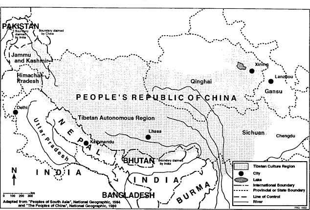
The Sherpas are one of a number of peoples of Tibetan origin and cultural affinities who have migrated south to settle the northern regions of the Himalaya. In Nepal there are several such peoples who inhabit the Great Himalaya, the trans-Himalayan valleys of western and central Nepal that lie between the Himalaya and the Tibetan plateau, and some parts of the midlands. These peoples are part of a much larger population of more or less ethnically Tibetan peoples who number more than six million and who occupy a territory of more than two million square kilometers stretching from the Chinese provinces of Gansu, Sichuan, and northern Yunnan across Tibet to Ladakh, from China's Qinghai province south to the southern slopes of the Himalaya, and along the full length of the Himalaya from Arunachal Pradesh to Kashmir. Across this Tibetan culture region (map 3) there are scores of peoples whose languages, religions, systems of social organization, economies, land-use practices, architecture, and styles of dress and ornamentation share strong resemblances. These similarities include Tibeto-Burman languages closely related to Tibetan; adherence to sects of Tibetan Buddhism; domestic and religious architecture featuring white, stone-walled structures with characteristic window patterns and other distinctive features; settlement sites at altitudes of more than 2,000 meters; cultural preferences for raising yak, sheep, and barley; distinctive traditional woolen dress consisting of a black or brown, extremely long-sleeved cloak for men and a dark, woolen dress with a striped apron for women; and special value put on certain types of jewelry, including silver amulet boxes and necklaces featuring coral, turquoise, zi stones, and silver.[23]
In Nepal peoples who have Tibetan-like oultures inhabit more than a quarter of the land area of the country. They comprise only a very small part, however, of Nepal's population of eighteen million.[24] Those who
Map 3.
The Tibetan Culture Region
live closest to the Tibetan border and most closely resemble the Tibetans in culture constitute less than 1 percent of Nepal's population. These peoples, among them the Sherpas, are sometimes referred to as Bhotes or Bhotias.[25]
People who call themselves Sherpas inhabit much of northeastern Nepal between the Sun Kosi and Arun rivers and form a part of the population of several other areas as far west as the Helambu (Yelmo) region northeast of Kathmandu and perhaps as far east as the Sikkim border.[26] The heartland of Sherpa country is the upper Dudh Kosi valley and the valley of one of its major tributaries, the Solu Khola. Often known as Solu-Khumbu, this region according to legend was the first area settled by the ancestors of the Sherpas after their migration from Tibet some nineteen generations ago. It remains the main population concentration of Sherpas today, with approximately 17,000 of what may be a total of 20-25,000 Sherpas in Nepal and as many as 30,0000 in the Himalaya as a whole.[27] This core population inhabits several geographically distinct territories that also vary to some degree in culture. The three most important of these in terms of area and population are Khumbu, Pharak, and Shorung, all of which are located in the Solu-Khumbu district of eastern Nepal. Despite their close proximity these three regions differ considerably in altitude and topography, spanning the full altitudinal range of Sherpa settlement. The Sherpas of Khumbu inhabit the rugged Great Himalayan highland valleys in the headwater region of the Dudh Kosi valley, their lands virtually all above 3,000 meters. Pharak is south of Khumbu in the Nepal midlands reaches of the Dudh Kosi valley. Here villages are situated between 2,300 and 2,800 meters. Shorung is located west of Khumbu and Pharak and reaches from the hill country of the Nepal midlands to the Great Himalaya. According to some Sherpas' reckoning it includes the Manidingma region of the west bank of the Dudh Kosi as well as the valley of the Solu Khola and the interfluvial uplands. Shorung villages vary in altitude from approximately 2,000 to 3,000 meters. Differences in the topography, climate, and vegetation of these three areas have supported very different economies based on differences in seasonal, altitudinal land use and associated variations in agricultural and pastoral practices and forest exploitation.
The Solu-Khumbu Sherpas, and particularly the Sherpas of Khumbu, are the Sherpas who have won worldwide admiration for their strength, endurance, courage, indomitable good spirits and joy in life, deep faith in Buddhism, and their relatively egalitarian and open society. Khumbu Sherpas initially earned their world renown through reports of their mountaineering exploits during the first half of this century. Their reputation was built especially on their performance on the series of British expeditions to Everest. Sherpas had become legendary in mountaineering cir-
cles by the 1920s when the British began awarding the finest climbers among them the title of Tigers. But relatively little was known about their homeland and culture even as late as 1953 when Tenzing Norgay and Sir Edmund Hillary reached the summit of Everest, an event which made Sherpa a household word around much of the planet.[28] Foreigners had been banned from traveling to Khumbu until 1950, when the Nepal government began to relax the policies that had previously made Lhasa more accessible to foreigners than the highlands of Nepal.[30] It was only in autumn 1950 that the first small group of British and American mountaineers was permitted to make the long journey on foot to the southern foot of Mount Everest and experienced for the first time the alpine grandeur of the Khumbu valleys and the generous hospitality of the Sherpa villages. Other mountaineers soon followed in a steady stream of expeditions and were joined by journalists, scientists, cartographers, the Hillary schoolhouse and hospital building teams, and finally in the 1960s by ordinary tourists. Sherpas also attracted considerable anthropological attention. One of the most distinguished anthropologists of South Asia, Christoph von Fürer-Haimendorf, conducted the first ethnographic studies of Khumbu Sherpas in 1953 and 1957. Fürer-Haimendorf's classic monograph, The Sherpas of Nepal (1964) and his later, more detailed treatment of the Sherpa economy and its changes between 1957 and 1971 (1975) focused primarily on Khumbu Sherpas and provided a firm ethnographic base for subsequent, more specialized anthropological and geographical Sherpa studies. Anthropologists have examined Khumbu Sherpa population dynamics (Pawson, Stanford, and Adams 1984), ethnohistory (Ortner 1989), religion (ibid.), shamanism (Adams 1989), festivals (Jerstad 1969), and the regional socio-economic and cultural changes that have accompanied tourism development and the establishment of such new institutions as schools and Sagarmatha National Park (J. Fisher 1990).[30] Geographers have also contributed to the increasing body of writing on Khumbu land and life with accounts of exploration and travel (Gurung 1980; Jackson 1955) and studies of geomorphology (Byers 1986, 1987b), natural hazards (Zimmerman, Bichsel, and Keinholz 1986), vegetation change (Brower 1987; Byers 1987b; Stevens 1986b, 1989), erosion (Byers 1987b ), pastoralism (Bjønness 1980a ; Brower 1987; Palmieri 1976; Stevens 1989), tourism impacts (Bjønness 1980b , 1983; Stevens 1988b , 1989), and cultural ecology (Stevens 1989).[31] Although most anthropological and geographical research has focused on the Sherpas of Khumbu, there have also been a number of studies of the Shorung Sherpas (including Funke 1969; Kunwar 1989; March 1977; Oppitz 1968, 1974; Ortner 1978, 1989; Paul 1979, 1982) and some work on other groups including the Rolwaling Sherpa (Kunwar 1989; Sacherer 1975, 1981), the Chyangma Sherpa (Limberg 1982), the Sherpas of the Bigu region (Fürer-Haimen-
dorf 1984; Kunwar 1989) and the multiethnic valleys of the Helambu region (N. Bishop 1989; G. Clarke 1980a , 1980b ).
From an anthropological perspective Sherpas have been widely characterized in terms of such fundamental features as language, clan structure, religion, and shared history. They have been classified as racially Mongoloid, linguistically Tibeto-Burman, and culturally "Bhotia" or "Tibetan" in terms of general orientation and origins.[32] On the basis of these basic traits the Sherpas of Solu-Khumbu can indeed be readily distinguished from neighboring non-Sherpa Tibetan, Rai, Gurung, Tamang, Sunwar, and Magar groups: Solu-Khumbu Sherpas speak Sherpa, a language distinct from the languages of these other peoples and from the national language, Nepali, which is a member of the Indo-European language family. They belong to one or another of a certain set of exogamous patrilineal clans. They believe in Tibetan Buddhism and specificially are adherants of the Nyingmapa sect. And they are descended (or at least some core of their clans trace their descent) from a small set of immigrant families who came to Nepal from Tibet more than four centuries ago.
Khumbu Sherpas distinguish themselves from the neighboring peoples they call Dongbu (Rai and Gurung), Rongba (Nepali), Tamang, and Pürba (Tibetan).[33] Usually they draw these contrasts on the grounds of territorial homeland, language, religion, and social structure.[34] While these attributes are the ones most often raised as central facets of "Sherpaness," a number of other characteristics are also often mentioned. Many Khumbu Sherpas talk of Sherpas (by which they actually usually mean specifically Khumbu Sherpas) being distinguished from other peoples by such things as their houses (including details such as materials used, styles of wall, window, and roof construction, and the placement and design of the roof, window, and house-pole prayer flags), clothes (including the cut of women's dresses and the style of their aprons), regional, village, and household festivals and rites (Dumje is especially cited, while Losar, Yerchang , and Pangyi are also mentioned), community offices through which temples, festivals, and natural resources are managed, and styles of livelihood and land use.[35]
Sherpas are undoubtedly most closely culturally related to their neighbors to the north, the Tibetans, with whom they share many cultural features. Their languages are closely related. While Sherpa, unlike Tibetan, is an unwritten language (and hence the considerable confusion over its orthography), it has a similar structure of Tibetan and according to one estimate may have 50 percent cognates with central Tibetan (Hutt 1986:17).[36] Sherpa social structure, like that of Tibet, includes both nuclear and stem families and accepts polygamous as well as monogamous marriage.[37] Like the people of at least some parts of Tibet, Sherpas trace their lineage and choose their spouses with reference to their affiliation in
exogamous, patrilineal clans.[38] They follow a Mahayana form of Buddhism developed in Tibet (Vajrayana or "Tibetan" Buddhism) and more specifically adhere to the Nyingmapa or "Red Hat" sect developed in Tibet in the eighth century.[39] As in Tibet there is respect also for divinities and powers in the natural landscape such as yul lha (regional mountain gods) and lu (spirits of springs and trees). Sherpa domestic and religious architecture are closely related to Tibetan styles.[40] In some though not all Sherpa regions, as in Tibet, there is a preference for raising yak and barley. Sherpas also share with Tibetans some taste in clothing and personal ornamentation as well as many other customs and beliefs.
Such similarities are not surprising considering the relatively recent migration of Sherpas to Nepal and the way in which—in Khumbu at least—continuing Tibet immigration has constituted a major component of nineteenth- and twentieth-century population growth. Close cultural contact between Khumbu and Tibet has also been maintained by trade, pilgrimage, the custom of devout Sherpas going to Tibet for religious instruction, and Khumbu's long appeal to Tibetan monks as a place for meditative retreat or careers as village lamas. Together this high level of interaction may have contributed to the greater "Tibetaness" that some other Sherpas find characteristic of the Khumbu Sherpas. There may also have been political links at one time between Khumbu and Tibet. There are oral traditions of taxes paid to Tibet in the early nineteenth century. People point out the former site in Nauje of the house of one of these tax collectors, and near Nauje is a ruin which is considered to have been a Tibetan fort (dzong ) that is said to have been overrun by Nepalese forces during the 1855-1856 war between Nepal and Tibet.[41]
Even though all Sherpas have strong historical and cultural ties to Tibet, both they and their Tibetan neighbors consider Sherpas to be a distinct people. During nearly twenty generations of life south of the Himalaya Sherpas have combined a heritage brought from Tibet with their own inspirations, developing a culture distinctively their own. They point out a number of basic differences between themselves and Tibetans. Sherpa is a distinct language. Sherpas have their own local gods, spirits of places, clan gods, and regional gods. They celebrate distinctive religious festivals such as the major summer celebration of Dumje held in Khumbu, Shorung, Dongritenga, Golila, and Rimijung in Pharak. Sherpa clans are for the most part different from those of Kham; all but two of the more than twenty clans recognized by Solu-Khumbu Sherpas are believed by them to have been developed after their arrival in Nepal. Some life-cycle rites are different. There are differences in vernacular architecture. Sherpa and Tibetan land use (at least the land use characteristic of the adjacent Tingri region) also varies. In most Sherpa regions, including Khumbu, yak and sheep are not as important as they
are in Tibet. In some Sherpa areas, again including Khumbu, yak-cattle crossbreeds are raised, contrary to the practice followed in Tingri and some other parts of Tibet where there are religious reservations against such breeding. And while Khumbu Sherpas, like Tibetans, prize barley, they give it a much less important role in their agriculture and diet and emphasize buckwheat and tubers more.
Sherpa Regions
People who identify themselves as Sherpa and are recognized as such by other Sherpas and their non-Sherpa neighbors inhabit a considerable part of the highlands between the Sun Kosi and the Arun rivers, land that today falls within the administrative districts of Solu-Khumbu, Dolakha, Ramechap, Olkadunga, Sankhuwasabha, and Khotang. There are apparently also Sherpa villages west of the Sun Kosi in the upper Balephi Khola valley (Sindhupalchok district), and people who claim descent from these (and possibly other Sherpa-inhabited areas) also form a component of the multiethnic population of the Helambu region of Sindhupalchok just to the northeast of the Kathmandu valley.[42] Sherpa settlement as far west as the Sun Kosi and as far east as the Arun river can be related to migrations from Solu-Khumbu as recently as the nineteenth century.[43] As previously mentioned, there are also Sherpas in the Darjeeling district of the Indian state of West Bengal, the descendants of Solu-Khumbu emigrants who were attracted in the late nineteenth and the first half of the twentieth centuries to economic opportunities there (particularly to mountaineering and porter work).[44] The inhabitants of a number of high-altitude settlements in the far northeast corner of Nepal near Taplejung (including the village of Gunsa) are also often referred to as Sherpa (Bremer-Kamp 1987; Sagant 1976). Fürer-Haimendorf suggests that these families migrated from Shorung (1984:3). In the late nineteenth century, while traveling through that region, Sarat Chandra Das was "told that the upper part of the valley [of Kangpachan] was first inhabited by Tibetans called Sherpas, migrants from 'Shar Khumbu'" (Pradhan 1991:70).
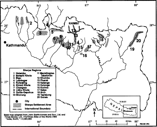
Khumbu Sherpas consider themselves one of as many as twenty (depending on who is counting and his or her familiarity with outlying areas) different Sherpa groups in Solu-Khumbu district and the adjacent Dolakha and Ramechap districts to the west and Khotang, Bhojpur, and Sankhuwasabha districts to the east and three groups further afield. These regions are listed and shown in map 4.
Immediately to the south of Khumbu in the middle reaches of the Dudh Kosi (as far as the village of Surke and the Chutok La beyond it) is an area considered to be the homeland of the Pharak Sherpas. South of them are a group that some Khumbu Sherpas call Katangami, people of
Map 4.
Sherpa Settlement Area and Regions
Katanga, who live in and near the Sherpa-Magar village of Kharikhola. South of Kharikhola the eastern Dudh Kosi valley is inhabited by Dongbu (Rai in the north and Gurung in the Ra Khola tributary) and Rongba (Hindu hill castes). Farther to the east, however, there are other Sherpa settlement areas beyond the Pangkongma La in the Hinku Khola and adjacent areas including Kulunge, the Kurima area to the southeast, and Sanam, Share, and other small settlements near the Salpa Bhanjyang (pass). Still farther to the east there are Sherpas living in small settlements such as Murde, Kuwapani, and Hurhuri on the ridge-crest of the eastern slope of the Arun valley as well as at Tashigaon, Navagaon, Yangding, Shashiwa, and other places on several west-bank tributaries of the Arun and possibly at Yakua farther upstream.[45] The high country east of the Arun is inhabited primarily by peoples who settled there from Tibet in earlier times, but who are not directly related to Sherpas. The far northeast corner of the country, the Gunsa area northeast of Taplejung, however, is settled by people who may have at least some of their roots in Solu-Khumbu and who continue to make trading trips to Shorung today. West of the Dudh Kosi is more Sherpa territory. The area around Manidingma and Takshindo is sometimes referred to as Takshindo by Khumbu Sherpas who consider it different from Shorung proper. Shorung is considered to be the area from the ridge crest at Takshindo to the Lamjura pass and Pi Ke peak in the west, and from the high valleys at the foot of the sacred peaks of Numbur, Khatang, and Karyalong to the ridge south of the bend which the Solu Khola takes on its way east to the Dudh Kosi. Beyond Pi Ke and the Lamjura La there are three other Sherpa-inhabited regions east of the Khimti Khola watershed: the villages along and near the Likhu Khola, the village of Chyangma (which is jointly inhabited by Sherpas and Newars who settled there at least nine generations ago), and the villages of Golila and Gepchua. Farther west there are Sherpa villages near Jiri in the Khimti Khola region, Lambogar, Rolwaling, and the Bigu gompa (temple) area west of the Tamba Kosi. As already mentioned there may also be Sherpas as far west of the Sun Kosi as Helambu, although further research is needed to fully establish this. Khumbu Sherpas familiar with these various areas from trade, pilgrimage, and mountaineering and trekking work draw numerous contrasts between Khumbu culture and that of these other Sherpa groups.[46]
Khumbu Sherpas thus have a well-defined sense of themselves as distinct both from other Sherpas and non-Sherpa peoples. Yet the question of what and who are Sherpas, or even Khumbu Sherpas, remains complex. In recent years the fame, status, and economic opportunities of the Solu-Sherpas have sometimes led Tamangs (G. Clark 1980b ; Fricke 1986:30) and Rais (Fürer-Haimendorf 1984) to claim to be Sherpas in
order to obtain tourism work. In the Taplejung area some non-Sherpa high-altitude dwellers reportedly refer to themselves as Sherpas rather than as Bhotias when dealing with lower-altitude people as a way of affirming their Nepalese rather than Tibetan nationality. In the Arun region some people call themselves Sherpas who have no association with Solu-Khumbu while lower-altitude peoples in that region have begun to use the term Sherpa "as a generic term for all Tibetan-origin people" (Parker 1989:12). Within Khumbu itself there is even some confusion over who is and is not Sherpa. Khumbu Sherpas have long drawn a distinction between the older clans, the descendants of early settlers, and those who came more recently and have drawn a far sharper line between Sherpas and Khambas, the descendants of immigrants from Tibet and other Bhotia areas. Lacking membership in a patrilineal Sherpa clan, these immigrants were not only considered different from Sherpas but were treated with prejudice even though in Khumbu intermarriage with them was tolerated and took place.[47] This remains true today to a lesser degree. Khamba families intermarry freely with Sherpas, hold village offices, and are generally fully integrated into Khumbu society. Many now call themselves Sherpas and seem to be accepted as such within and outside of Khumbu. Further complexity is added by the fact that some of the central qualities by which Sherpas define themselves, as well as those by which outsiders distinguish them, have undoubtedly changed through time. Trading with Tibet, for example, was once an important aspect of Khumbu Sherpa identity, a quality which set them apart from Pharak and most Shorung Sherpas. Due to the decline in trade since the 1960s, however, this activity no longer distinguishes most Khumbu Sherpas from their neighbors.
For all the socioeconomic and cultural change of recent decades Khumbu Sherpas have not lost their sense of themselves as a people, and that to some important degree may be due to their having maintained their language, religion, social structure, and homeland. Territory is considered a fundamental aspect of identity. Khumbu Sherpas see themselves as the people who live in a particular group of four valleys on the border of Tibet. People who live beyond this region may be Sherpas, but are not Khumbu Sherpas even when, as in the case of the Pharak Sherpas, they may be culturally and socially very closely related indeed. Even the children of emigrant Khumbu Sherpas are often regarded as Darjeeling Sherpas, Shorung Sherpas, Kulunge Sherpas and so on rather than "Khumbuwa," people of Khumbu. It seems likely that the children of Khumbu Sherpas who have grown up in Kathmandu, speaking Nepali rather than Sherpa and living extremely different lives from their cousins in the mountains, will be considered to be "Kathmandu Sherpas" rather than Khumbu ones if they do not return to make their lives in Khumbu.
Finally, important facets of culture can also vary even among Khumbu villages. Local differences could be noted in such things as communal institutions and the conduct of festivals and village rites as well as in economic emphases.[48] Such variation cautions against generalizations about "Khumbu Sherpa" and "Sherpa" beliefs and practices on the sole basis of familiarity with the way things are done in a few settlements.
Population and Settlement Patterns
Most of the present population of Khumbu are Sherpas who are members of a group of "old clans" that trace their origins to the original Tibetan settlers of Solu-Khumbu. There are also substantial numbers of "new clan" Sherpas, a large percentage of Kamba families, and some families descended from unions between Sherpas and Gurungs, Tamangs, Newars, and Chetris.[49] Although they all consider themselves Sherpas there does remain some sense of social hierarchy based on these ethnic differences.[50] Besides these main components of Khumbu society there are more recent Tibetan refugees (about twenty-five families), a few households of lower-caste Hindu Kami blacksmiths (nine families) and tailors (two families), several upper-caste Brahmans and Chetri Hindu schoolteachers, two Tamang families, and a Magar family. There are also more than three hundred Hindu Nepalis stationed in the region with the police, army, post office, bank, Northern Boundary Commissioner's office, the government health post in Nauje, and the national park (Fürer-Haimendorf 1984:32). Scores of Rais, Magars, and Nepal midlands Sherpas also spend months or even years in Khumbu as household servants, agricultural laborers, fuel wood cutters, and stonecutters, and masons.[51]
Khumbu is unusual among Sherpa regions in the relatively high percentage of its population considered to be Khamba rather than of old or new clan Sherpa descent. This percentage varies regionally. Fürer-Haimendorf determined in 1957 that Khambas constituted 49 percent of the households of Khumjung, the region's largest village.[52] The percentage of Khambas in Kunde, Phurtse, and Pangboche was 33, 37.5 and 39 percent respectively (Fürer-Haimendorf 1979:26). In Nauje they were probably then a majority. For most purposes, however, there is no need to distinguish between Sherpas and Khambas and in this book I will do so only in the rare cases when historical and contemporary differences in land-use patterns and other economic activities need to be noted. Khamba families have all lived in the region now for several generations and differences between them and old-clan Sherpa families have diminished with time. Khambas intermarry with Sherpas, speak Sherpa, dress in Sherpa-style clothes, live in Sherpa-style houses, and participate fully
Table 1. Village Household Numbers and Population | ||||
Number of Households[*] | ||||
Village | 1957 | 1991 | Population (1979) | |
Nauje | 73 | 123 | 488 | |
Khumjung | 93 | 135 | 622 | |
Kunde | 45 | 50 | 237 | |
Pangboche | 58 | 83 | 347 | |
Phurtse | 63 | 62 | 287 | |
Thamicho | 192 | [**] | 707 | |
* The 1991 Nauje total includes four Zarok households. Ninety-four of the Nauje households and 125 of the Khumjung households were Sherpa or Khamba. The 1991 Pangboche figures include five Milingo-, five Changmiteng-, and five Dingboche-based households. The Thamicho total includes all households with main dwellings in the Bhote Kosi valley other than in Nauje. No household is tallied more than once, although some own houses in more than one main settlement. Only families who were resident in the area in 1991 were counted. Monks and nuns are not included in the population totals. | ||||
** A 1991 count of Thamicho households is not available. The complex settlement pattern of Thamicho makes it easy to double-count households. Fürer-Haimendorf's 1957 count may be high. | ||||
From Fürer-Haimendorf 1964, Sherpa 1979, and fieldwork. | ||||
in community offices and religious activities. Formerly many Khambas were among the poorest families in Khumbu, but there is little distinction today between the lifestyles and land use of poor Khamba families and poor Sherpa ones or between wealthy Khambas and wealthy Sherpas. Khamba households have been among some of the very wealthiest in Khumbu since at least the 1940s when some Khambas became major traders, and the most of the conspicuously poor Khamba households of the 1950s have prospered since then as a result of involvement in tourism.
Village populations of Sherpas (including Khambas) are given in table 1 based on a 1979 census conducted by Nima Wangchu Sherpa on behalf of Sagarmatha National Park. James Fisher tallied a total of 2,474 people in a Khumbu population count in 1978 as against Nima Wangchu Sherpa's 2,836 permanent residents (including non-Sherpas) in 1979 (Sherpa 1979:7). The most recent census, conducted in 1982 by Pawson and his associates, totaled 2,524 Sherpas (Pawson, Stanford, and Adams 1984:75).[53] The collection of census data is difficult in Khumbu due to the seasonal dispersion of the population among different main and secondary settlements as well as the absence of many men on mountaineering expeditions and trekking work. An increasing number of young men and families also reside in Kathmandu for part of the year or sojourn there for an indefinite period while still maintaining a house in Khumbu and expecting to return.
The important question of the regional rate of population growth, a matter of great importance to land use and environment, is complicated by the lack of reliable census material. Ortner reports that Fricke estimates that the Sherpa population of Solu-Khumbu as a whole has doubled every sixty years since the time of original settlement (assuming that the original settlers numbered about fifty) (Ortner 1989:209, n. 1), while Oppitz earlier estimated the population doubling rate at forty-nine years (Oppitz 1968:103). These calculations, however, refer to net population growth, not natural increase. They do not distinguish between local Sherpa population growth and historical immigration and emigration, including continuing immigration since 1800 from Tibet. It is known that the population of Khumbu in 1836 consisted of at least 169 tax-paying households (Fürer-Haimendorf 1979:118), although whether or not other families went untaxed (e.g., landless immigrants) is not certain. The number of Sherpa and Khamba households in Khumbu today is slightly more than 500, meaning that the regional population has apparently tripled during the past 150 years. Much of that gain may have been in the past sixty to seventy years. Elderly residents of Kunde, Khumjung, Nauje, and Phurtse testify that the number of houses in their villages has doubled or more than doubled in their lifetimes. Even the increase in the number of households since 1957 is significant in many villages.[54]
Multialtitudinal Settlement Khumbu Sherpas have developed a complex pattern of seasonal movement between houses in their main villages and other dwellings situated at different altitudes and as far as twenty kilometers away. Some families maintain as many as half-a-dozen houses and herding huts scattered throughout one or more valleys, living in each for a period ranging from a week to many months per year depending on their pattern of herding and the ways in which they integrate these with crop-tending requirements, social responsibilities in various places, and personal preferences. The complexity of scheduling agricultural and pastoral activities at a number of different sites often leads families to divide forces temporarily between several bases. The locations of the major villages and the scores of lower- and higher-altitude secondary settlements are shown in map 5 by settlement type, and the individual settlements of the Bhote Kosi, Dudh Kosi, and Imja Khola valleys are shown in maps 6 and 11.[55]
Villages (Yul) Level field sites in the steep terrain below 4,000 meters are rare and prized, and the eight main villages of the area hug the most prominent bits of a relatively gentle terrain between 3,400 and 4,000
Map 5.
Khumbu Settlement Pattern
meters. Half of the total Khumbu population inhabits three villages, Nauje (3,400m), Khumjung (3,790m), and Kunde (3,820m) in southernmost Khumbu near the confluence of the Bhote Kosi and the Dudh Kosi rivers.[56] The middle reach of the Bhote Kosi valley in western Khumbu, an area known as Thamicho, is a second major area of settlement. The three main Thamicho villages, Thami Og (lower Thami), Thami Teng (upper Thami) and Yulajung, are all situated at about 3,800 meters. Thami Teng and Yulajung occupy alluvial terraces on opposite sides of the Bhote Kosi, whereas Thami Og is located on the north bank of the Thami Chu just above its confluence with the Bhote Kosi and immediately south of the prominent old lateral moraine which stands between it and Thami Teng.[57] Eastern Khumbu has two major villages, Phurtse (3,840m) in the Dudh Kosi valley just above the confluence of that river and the Imja Khola and Pangboche (4,000m) on the Imja Khola just six kilometers to the east. Besides these villages there are also several smaller settlements which serve as the main base for a majority of the families who own houses in them. These include Milingo near Pangboche on the Imja Khola, Zarok just above Nauje, and several small settlements in the vicinity of Thami Teng including Worsho, Chanekpa, and Ong. In most cases families living in these settlements join with nearby main villages for a variety of social, religious, and community land-management purposes.
Main village houses are substantial structures of unmortared stone with gabled roofs of slate, fir shakes weighted with stones, or corrugated iron. Until recently all construction materials were locally obtained, including the white clay used to give houses their distinctive color. The tree-felling restrictions which the national park implemented in the late 1970s, however, have since meant that nearly all timber has had to be imported from Pharak. Sheets of corrugated iron are brought by porter from the road end at Jiri, and glass is now often flown in to Lukla.
All but the poorest families live today in two-story houses. These are constructed along very standardized designs and floor layouts and are generally about five by twelve meters in size. The lower story provides a stable for livestock and a storage area for grain, fodder, and fuel wood. The upper story is usually a single, large, open living room with front (usually south-facing) windows above a long window bench and a hearth area. The windowless back wall is lined with shelves on which the household wealth of copper water-storage vessels, brass cooking pots, carpets, and other worldly goods is displayed. Wealthy families may devote a separate room on the left side of the upper floor to a family chapel, but more often a simple altar located on the left wall of the main room suffices. Often houses face in a similar direction, an orientation influenced not only by sunlight and slope but also by geomantic beliefs about
auspicious and inauspicious directions and the danger of having a house face places such as caves inhabited by demonesses.
The eight major villages differ greatly in size and economic orientation as well as in such features as the conduct of community religious ceremonies and local resource-management institutions. Nauje is the region's second largest village.[58] Long the home of many of the region's major traders and a place where Rais, Sherpas, and Tibetans bartered salt, wool, and grain, it is today Khumbu's administrative, commercial, and tourist center and has grown into a small town with ninety-four resident Sherpa familes and a third as many non-Sherpa households.[59] Here is the region's only bank as well as a post office, government-operated clinic, elementary school, the office of the Northern Boundary Commissioner, and the first dental clinic in northeastern Nepal. On Mendelphu hill, overlooking the tiers of tightly clustered houses of the village proper, is the complex of buildings that forms the headquarters of Sagarmatha National Park. Part of the village has developed into a tourist district that in spring 1991 had twenty-one shops and eighteen lodges. Village families also run two more Sherpa lodges adjacent to national park headquarters at Chorkem. At one edge of the settlement is the site where on Saturdays the region's only periodic market is held. Here Rais and other traders sell grain and goods brought from settlements and road ends as far away as ten days' journey on foot. At night the village glows with more than 400 electric lights installed in 1983 with UNESCO aid and powered by a microhydroelectric turbine on the stream which flows from the village spring.
All the other Khumbu villages retain the atmosphere of rural settlements and their only signs of tourism development are a few modest lodges and teashops.[60] Khumjung, a sprawling village just an hour's walk from Nauje, is by far the largest of these. Its name, which may mean Khum (or Khumbila?) valley, may refer to its site in a valley at the foot of the sacred peak Khumbila.[61] With 135 Sherpa households it has the largest Sherpa population of all the Khumbu main villages. Here is the region's main elementary school, established in 1961, and its only secondary school. Both were built and maintained through the work of Sir Edmund Hillary and the Himalayan Trust organization. Adjacent to Khumjung and slightly higher in altitude is Kunde, upper Khum. Kunde has only fifty Sherpa households but is renowned as the location of the hospital established by the Himalayan Trust in 1966.[62]
Pangboche, the major village of eastern Khumbu, has two distinct sections that between them have sixty-eight households. The older, upper village (Pangboche Te Lim) occupies an amphitheater some 150 meters above the Imja Khola and directly below the spectacular summit of Tawache. This is the main settlement, with 89 percent of the village
households, most of them clustered in tiers around the amphitheatre walls and the village temple. The more recently established Wa Lim occupies a large alluvial terrace just above the Imja Khola. The seventeen families here do not have land holdings in the upper village.[63] They are, however, fully integrated into a joint social and ritual life.
The village of Phurtse perches on a small shelf 400 meters above the confluence of the Dudh Kosi and the Imja Khola. The name is said to refer to Lama Sanga Dorje's miraculous feat of having flown to this spot, leaving several marks of his landing on a local boulder. Here are the dispersed houses of sixty-two families. The older section of the village occupies the center and lower parts of the slope, whereas the prominent, dense cluster of houses in the upper northeast corner is a development of the present century. The old, dense birch forest that covers a slope adjacent to the village on the north is one of several Khumbu sacred forests.
The Bhote Kosi valley villages of Thami Og, Thami Teng, and Yulajung are smaller than the other Khumbu villages. Yulajung indeed has only fourteen resident families, most of whom also have houses down valley at the gunsa (winterplace) settlement of Pare. Thami Teng, with twenty-two households in the village proper, is the largest of a set of closely situated communities on the west bank of the Bhote Kosi across from Yulajung. It is the home of a number of the few Sherpa families who are still trading on a small scale with Tibet and two of the largest Khumbu yak herds. Thami Og, childhood home of Tenzing Norgay, has twenty-seven households and on the slopes above it is one of Khumbu's two important monasteries. In the nineteenth century it was the home for at least three generations of the political leaders of the region. One Thami Teng Sherpa speculates that the names Thami Teng and Thami Og may refer to the flat character of the settlement sites and their relative locations. The first part he considers to derive from the Tibetan thang , a flat place, while the te and me suffixes refer to upper and lower sites. Yulajung may get its name from a linking of the Sherpa yul , "village," with jung , a flat valley.
Subsidiary Settlements (Gunsa, Phu) In much of the Himalaya and Tibet herders who pasture their stock in regions far from their home villages often live in tents or in shelters largely made of bamboo mats. A small number of peoples, including the Sherpas of Khumbu, Rolwaling, and Gunsa, however, build substantial, stone herding huts. These may be located at altitudes either above or below that of the main village, and often crops are also grown at these sites. In Khumbu these huts are usually tiny, low-walled, stone structures with shake or slate roofs. Al-
most all are only a single story high and are seldom much larger than three by four meters with a port-hole-sized window or two, a dirt floor, and a simple hearth formed of three stones set into a tripod. Cramped and smoky at the best of times, they grow more so after the hay is cut from adjacent walled fields and the huts become not so much dwellings as hay-stores. Khumbu herders also make use of caves and resa , low circles of stones roofed with bamboo mats or tarps.
High-altitude herding settlements are known as phu and are sometimes also referred to as chusa (livestock place) or yersa (summer place). The highest are located at an altitude of 5000 meters in the alpine regions of the uppermost valleys. Gunsa (also referred to as chusa) are located below the main villages.[64] Many gunsa and some phu are not only herding bases but also have substantial areas in cropland. Houses in both gunsa and phu may be owned by families who have no interest in herding. Some of the subsidiary settlements between 4,000 and 4,400 meters are major crop-production sites, including Dingboche (4,358m) in the Imja Khola valley, Tarnga (4,050m) in the Bhote Kosi valley, and Na, Charchung, Tsom Og, and Tsom Teng (4,280-4,400m) in the Dudh Kosi valley. Houses in these places and in some crop-producing gunsa may rival a family's main village house in size. For a few families such houses are actually main residences and they may have no house in a main village. I will henceforth refer to upper valley settlements where a great deal of cultivation takes place as "secondary high-altitude agricultural sites" to distinguish them from high-altitude phu settlements that are primarily herding bases and hay-cultivation areas.
There are more than 300 high-altitude herding huts in at least eighty-six distinct settlements (not including resa). Most have associated hay fields and some also have small areas in potatoes. Some high-altitude herding settlements consist of only a single hut or resa whereas others have as many as thirty. Most are inhabited by families from several different main villages. There are twenty-three gunsa settlements in Khumbu typically situated on fragments of terraceable land deep in the gorges. Many are located as much as 500 meters below the fields of the main village. Like the high herding sites gunsa are small settlements that are often bases for families from several different villages. The largest have fewer than thirty houses. Some of the secondary high-altitude agricultural sites, by contrast, are quite large. Tarnga has more than sixty houses that belong to families from all the Thamicho villages and a few Nauje families. Dingboche has sixty-five houses, most of them owned by Pangboche villagers but some of them the property of families from Khumjung, Kunde, and Nauje. Five families have their main houses there today.
Settlement History Khumbu Sherpas believe that their ancestors came to Nepal from Kham, a region on the eastern edge of Tibetan-inhabited territory 1,200 kilometers from Khumbu. Written clan records kept by Shorung Sherpas also claim Kham as the ancestral Sherpa homeland and in particular trace a migration from the Salmo Gang area (now in China's Sichuan province) near Derge in the upper Jinsha Jiang (Yangzi) region (Oppitz 1968; Teschke 1977). Sharwa , as Sherpas call themselves, means "easterners" or "people of the east" and may reflect this migration.[65] Oppitz suggests that the number of people involved was quite small, perhaps as few as twenty-five to fifty persons (Ortner 1989:26). Based on references in the texts to one of the emigrants being a student of Terton Ratna Lingba (1401-1477) Oppitz (1968:143) suggests that the original emigration from Kham "took place at the turn of the 15th to the 16th century.[66] The reasons for the departure of the small group of families from Kham can only be guessed at. Oppitz speculates that military incursions by Mongols from the Koko Nor (Qinghai Lake) region of present Qinghai province may have been a factor (ibid.:143-144) and there is mention in the texts also of dreams and visions that guided the leaders of the group (Ortner 1989:29). According to Konchok Chombi the emigrants' reluctance to take part in a coming war was also an important reason for their departure from Kham.
The migration took a period of years. Both Oppitz and Khumbu traditions agree, however, that it was accomplished by the same band of people who set out from Kham. The emigrants did not take leave of Kham with an intention to cross the Himalaya, for they clearly hoped to settle in central Tibet. They were unsuccessful, however, in their efforts to find a new homeland in south-central Tibet. According to some accounts they attempted to settle first in the Lhasa area and then in the Tinkye area, where Oppitz suggests they settled for a few decades south of Tsomo Tretung lake. He relates the subsequent abandonment of the Tinkye area to a reference in the Ruyi to invaders called Dohor Durkhi, whom he believes may have been the Muslim armies of Sultan Sa'id Khan of Kashgar which, under the command of Mirza Muhammad Haider, campaigned against the Buddhist "idolators" and in 1531-1533 nearly reached Lhasa (ibid.:144). Oppitz speculates that the immigrants moved rapidly from Tinkye to the Tingri region just to the north of Khumbu and then crossed the Nangpa La into Khumbu around 1533 (ibid.:144). According to Khumbu legends the ancestors of the Sherpas may have also tried to settle in the Tingri area near Langkor, but found that they were unwelcome after their yaks grazed in the barley fields of local farmers.
There are two oral traditions about the Sherpa discovery of Khumbu.
According to one the way over the Nangpa La was first found by a hunter, Kira Gombu Dorje, when he was pursuing a quarry which in some versions was a musk deer and in others a blue sheep. Some people believe that the deer was actually the embodiment of Khumbu Yul Lha. In the second a scouting party of three friends (Lama Serwa Tungel, Mijen Thakpa, and Thimi Sangbu Tashi) reconnoitered the pass and the Bhote Kosi valley beyond it. According to Konchok Chombi's reckoning of his own genealogy, eighteen generations have been born in Nepal since the ancestors of the Sherpas crossed the Nangpa La into Khumbu.[67]
The immigrants who passed across the Nangpa La into Khumbu did not all settle there permanently. Most apparently continued south after a few years, following the Dudh Kosi valley into the lower-altitude forested regions of Pharak, Shorung and Golila-Gepchua. In Khumbu it is believed that a few immigrants remained in Khumbu and adjacent Pharak and that these families constituted the nucleus of what later became the Sherpas of Khumbu. This early Khumbu population was apparently very small and remained so into the nineteenth century despite population growth from natural increase and further in-migration.[68]
The families which originally crossed into Nepal are believed to have belonged to several different clans, the ancestors of the Khumbu clans of today.[69] Oppitz (ibid.:144) refers to these as the four protoclans (Serwa, Minyagpa, Thimmi, and Chakpa) and suggests that they may originally have had separate territories, although on this point Khumbu traditions offer no confirmation. In Shorung and the area just west of the Lamjura pass early settlements were apparently established on a clan-exclusive basis. How and when the multiclan villages characteristic of Khumbu developed is not known. Oppitz believes that the Thimmi protoclan originally settled the Bhote Kosi valley (primarily the lower valley between the later settlement at Thami Og and Nauje) between 1533 and 1550 while Minyagpa families settled Phurtse and Pangboche (Fürer-Haimendorf 1984:27-28). Over the course of a few generations a number of new clans were established. Some, according to oral traditions and genealogies, were the result of the fissioning of clans into sets of exogamous brother clans following a ban on marriage between the offspring of brothers. In other cases the new clans reflected a decision by new immigrants from Tibet to take clan names based on their areas of origin.
The first settlers from Kham must have found Khumbu a rather different place than it is today. According to legend Khumbu was then in its lower reaches far more densely forested than now and richer in wildlife. Some stories describe Khumbu as a wild area and also as a "god's place" which had been set aside from the ordinary world until it was revealed to the faithful as a refuge for believers.[70] The idea that divine guardianship kept Khumbu hidden until the arrival of the Sherpas also figures in a
legend of an early king who wished to settle in Khumbu but was deceived by the gods into believing that the area was uninhabitable. When he went up into the valleys of Khumbu the gods made him see only huge lakes that threatened to flood the lower country. He had established a palace on the great rock at Monjo, just south of Khumbu, but after this decided to abandon the region altogether. He is said to have eventually established his capital at Dolakha, a place more than a week's walk to the west, where he is now supposedly honored as a god.
There are a number of Khumbu oral traditions which recall that at the time of Sherpa settlement the region was already being used as summer pasture by Rai shepherds. Old stories refer to these summer visits, and certain ruins in high places in the Dudh Kosi valley are sometimes said to be remains of Rai shepherds' huts.[71] Another legend offers an explanation for the lack of permanent Rai settlement. This tale details the attempts of the Kulunge Rai culture hero Ma Pe to settle in Khumbu long ago. According to the story Ma Pe crossed into Khumbu by the now difficult Amphu Laptsa pass in eastern Khumbu and settled in the upper Imja Khola valley. He built a house and tried to cultivate fields at Dingboche. There he found his crops ill-suited to the altitude and he moved lower in Khumbu. There again the crops were poor and his subsequent attempts to farm other Khumbu sites were also discouraging. Eventually he gave up and moved farther down the Dudh Kosi valley where he found a suitable site at Bupsa near Kharikhola in Katanga. This has been, it is said, the highest and northernmost place of Rai rice cultivation ever since.[72] Other possible indications of early Rai settlement are remembered in the legend that Rais may be reincarnated in one place in Khumbu in the upper Imja Khola valley near the Tengboche monastery. There are also a number of place-names in Khumbu and Pharak which are said to date from Dongbu times (these may also refer, however, to nineteenth-century herding by Gurungs, who, like Rais, are called Dongbus by Sherpas). These names, such as Dusa and Ralha, refer to sheep- and goat-herding activities. There may even be an old recognition of Rai association with Khumbu in the name Khumbu itelf. The Dudh Kosi valley is known to Rais as a part of Majh Kirat called Khambuan, "land of the Khambu." And Rais in this part of Nepal have long referred to themselves as Khambu, tracing their lineage back to an ancestor named Khambuho (McDougal 1979:3). Perhaps Sherpas adapted a slightly modified pronunciation of this local regional name.
Rais would have found Khumbu an uncongenial place for the rice and millet that were presumably their main crops in that era before maize was a common crop in Nepal. But the possibility of Rai summer transhumance into Khumbu is plausible given current Rai sheep-herding
patterns in nearby areas. Summer pastoralists may also have augmented their food supplies by planting buckwheat, barley, or tubers. The ancestors of the Rais or even earlier predecessors in the Dudh Kosi valley might very well have used swidden cultivation in the then presumably well-forested lower Khumbu valleys or set fire to woodlands in order to improve grazing. Such practices might account for the very early habitation suggested by Byers on the basis of pollen studies which revealed cerealia grains which may date back 1,500 years (Byers 1987b :199, 204).[73]
Khumbu oral traditions recall early conflict between the immigrants from Tibet and the indigenous Rais in both Khumbu and Shorung. According to one legend the first settlers had already planted some crops when they were accosted by Rais who told them they could not grow crops or settle there because the land belonged to the Rais. The Sherpas then asked permission, pointing out that they had no food and could not return to Kham. The Rais relented.[74] Another story set a few generations later describes an armed conflict between Rais and Sherpas in southern Khumbu. Sherpas are said to thereafter have had to pay an annual tax to the victorious Rais, presumably until Prithivi Narayan Shah consolidated his control over the Dudh Kosi region in the late eighteenth century and made it part of the new Shah kingdom of Nepal.[75] Ortner (1989:84) suggests a date of 1717 for the Sherpa defeat. There is also a tradition that an early division of territory between Sherpas and Rais took place in the region of present southern Solu-Khumbu and Olkadunga districts.[76] Documents from the reign of King Rajendravikram Shah (1816-1847) note that parts of Solu-Khumbu and its pasture regions were formerly under Rai control (Pradhan 1991:62).
Early Settlement A rich body of oral traditions concerning early events in Khumbu depicts the Bhote Kosi valley as the center of population and political administration.[77] The rest of Khumbu in the early years of Sherpa habitation appears to have been a very sparsely settled, primarily wild country in which a few lamas had established religious retreats and temples.
Several legends are set within the Bhote Kosi valley during the first few generations of Sherpa habitation. A number concern Dzongnangpa, an autocratic administrator who persecuted Sherpa lamas and was ultimately assassinated. According to some accounts Dzongnangpa was originally a Tibetan official in Shekar (east of Tingri). After being disgraced there he crossed the Himalaya to Khumbu where he eventually obtained considerable power, began to rule in a style that was extremely high-handed, arbitrary, and offensive by Sherpa standards, and became
one of the classic villains of Sherpa oral traditions. The degree of his misrule is most vividly illustrated in his oppression of local religious figures. He is said to have been responsible for the death of one Sherpa lama at Zamde (near Mingbo in a tributary valley north of Thami Teng) and to have persecuted a second, Lama Sanga Dorje.[78]
The Tarnga area especially figures in the legends as an early settlement site. Tarnga today is a secondary high-altitude (4,050m) agricultural site famous for growing the best-tasting potatoes in Khumbu. In the early accounts it figures as the seat of Dzongnangpa's power. Some elderly Bhote Kosi valley villagers remember a large rubble pile said to have been the remains of Dzongnangpa's palace. It was also at Tarnga that yeti are said to have caused so much damage to Sherpa crops that the Sherpas staged a devious trap which very nearly caused the extinction of yeti in the region.
Tarnga would have been an appealing early settlement site. It is situated only slightly higher in altitude than today's main villages, has one of Khumbu's largest expanses of relatively level, arable land, and is one of the two places in the region in which irrigated barley can be grown on a large scale. One shortcoming is the absence of any adjacent woodland, but in earlier times Tarnga may have had better access to timber and fuel wood than at present. The highest patches of forest remaining today are located near Mingbo and Chosero, just south of Tarnga, and there may once have been shrub juniper cover or even open woodland nearer to Tarnga itself. If Tarnga was the early focus of settlement in the Bhote Kosi it is unclear why and when the center of settlement shifted to the present main villages of the valley. This certainly took place well over 150 years ago, for through much of the nineteenth century Thami Og was the political center of Khumbu.[79]
Some clues to the settlement of eastern Khumbu can be gleaned from the extensive set of traditions concerning Lama Sanga Dorje, the great spiritual hero of Khumbu history. Besides recounting Lama Sanga Dorje's magical feats these legends tell of his travels through Khumbu in search of auspicious places to mediate and to found temples, and his persecution by Dzongnangpa who was jealous of his powers and popularity among Sherpas.[80] Although this is not the place to discuss the details of the many stories of Lama Sanga Dorje's birth, life, and death, his role in the establishment of Pangboche is pertinent. After deciding to leave his earlier hermitages in the Bhote Kosi valley because of the escalating tension with Dzongnangpa, Lama Sanga Dorje is said to have explored eastern Khumbu for a site to establish a temple. He decided against building a temple at what later became Phurtse and also rejected the ridge where the Tengboche monastery was later built. Ultimately he built a small temple at Pangboche. There may have been earlier temples
in Khumbu, although what are called temples in the stories of the earliest Khumbu years may have been only the hermitages of lamas. Pangboche is clearly described as a temple and, more than that, as having originally been the place of worship for a community of celibate monks. Ortner speculates that it could have been founded between 1667 and 1672 (1989:49).[81] The site of the new community of Lama Sanga Dorje's spiritual followers was apparently intended to be in a remote place where they would not be harassed as they had been in the Bhote Kosi valley. According to one story there was both a community of monks and a nearby community of nuns.[82] After Lama Sanga Dorje left the area for Tibet, where he eventually died, these followers stayed on. Intermarriages between nuns and monks subsequently took place and a settlement grew up. The compact clustering of houses in the upper village, one villager noted, reflects its origin in the tightly grouped monks' houses that usually surround monastic temples.
It is unclear when Khumjung and Kunde were founded, but it seems likely that this took place after the immigrants had established a foothold in the Bhote Kosi valley and may have also come after the development of Pangboche. The establishment of the village of Kunde a short distance up valley from Khumjung may not have taken place at the same time as Khumjung's settlement and is assumed by some Sherpas to have come later, or at least to have developed more slowly. I know of no oral traditions concerning the establishment of the two villages, nor are they mentioned in the oral traditions of the early generations of Khumbu settlement. Khumjung was certainly settled long ago, for some families there trace eleven generations born there and believe that they were not the original settlers. Two early temples or religious retreats that do figure in the oral traditions, Gormuche and Lhonang, are said to have been located not far from Khumjung, but this casts no light on whether Khumjung had already been founded.[83] One of these hermitages belonged to Lama Sanga Dorje's father. There is an oral tradition that the valley where Khumjung later grew was a lake or marsh during the early period of Sherpa settlement. The first houses in the area are said to have been built on the slopes below Khumbila rather than on the flat valley floor.[84] Khumjung and Kunde, whenever they were established, might long have been relatively small settlements. This is suggested by the tradition that while temples were established in the sixteenth or seventeenth century in Thami Og and Pangboche there was no village temple in either Khumjung or Kunde until the 1830 establishment of Khumjung temple. Before this villagers journeyed either to Thami Teng or Pangboche for important events such as the Dumje rites (Khumjung villagers in this era went to Thami Teng whereas Kunde villagers, like Phurtse families, went to Pangboche).[85] Another suggestion of the rather late
settlement of the Khumjung-Kunde region is that Khumbu traditions relate that Khumjung and Kunde were first settled by people from the Paldorje, Chusherwa, and Jongdomba (Dzongnangpa?) clans (Fürer-Haimendorf 1984:28). The latter two clans are members of the seven "new clans" that Oppitz (1968:145) believes represent immigration from Tibet long after the early Sherpa settlement.
Phurtse was presumably founded after the establishment of Pangboche. The first families are reported to have belonged to the Shar Dorsum, Shar Tazum, and Shar Sundokpa clans (subclans of the Sherwa). The settlement took place long enough ago for subsequent changes in the definition of these "brother clans" and for abandoning the original strict bans against intermarriage between Shar Dorsum and Shar Sundokpa after the area was also settled by Shar Penakpa, Paldorji, and Sundokpa clan families. The original settlement must have been sometime before the early nineteenth century, for nine generations ago Phurtse families were among the early settlers of Nauje.
Nauje is considered to be the youngest of the Khumbu villages, dating only to the early nineteenth century. The settlement is mentioned (as Namche Bazar) in an 1810 A. D. Kathmandu document entitled "Order to Inhabitants of Solu Regarding Trading Rights Beyond Namche" discussing trade regulations (Regmi Research Collection , vol. 49:209, in Schrader 1988:245), and in an 1828 trade document seen in Khumbu by Fürer-Haimendorf (1975:61). Before the establishment of a village at the present site Sherpas from Khumjung had herding huts and fields in the area.[86] Permanent settlement in Nauje is thought to have begun when five Khumjung families made the place their main base. They are said to have been attracted to the site because of the spring, one of the finest in Khumbu. Other immigrants from Khumjung and also from Phurtse soon followed. The first houses were built on the south facing slope and one of them became the stopover for Tibetan tax collectors who came to Khumbu until the Nepali victory in the 1855-56 war between Nepal and Tibet.[87]
Khumbu became part of Nepal in 1772-1773 when the Dudh Kosi region was incorporated into the Kathmandu government of the Shah kings (Limberg 1982:149). Sherpas began to pay a small land and house tax to Kathmandu, the revenue being collected in Khumbu by eight Sherpa pembu who were overseen by a Sherpa gembu, the highest local official. This office was held by Thamicho men during the nineteenth century and by the powerful Tsepal, a resident of Nauje, in the early twentieth century.[88] The eight hereditary Khumbu pembu, also men of great power, prestige, and wealth, were mainly responsible to the Kathmandu government for collecting taxes, but also filled a much larger role in Khumbu society as patrons and arbiters.[89] They may once
have functioned as village headmen, but even in the early nineteenth century had ceased to do so and instead collected tax from clients who often lived in several different villages. This may have reflected migration of families from long-established settlements to new areas, with the families in such cases continuing to pay tax to the same pembu even though they now cultivated different areas. Whereas some villages had no resident pembu, others had several.
During the late nineteenth and early twentieth centuries Nepali administration of Khumbu was conducted by visiting officials and by the gembu and pembu on the behalf of Kathmandu. Only in the 1940s did the central government open up an office in Nauje, before that con-tenting itself with occasional visits by its officials. The region was remote from the capital and in many ways largely governed its own affairs. Yet the state did play an important role in some dimensions of Khumbu life. Government edicts about subjects as diverse as trade regulations, yak eating, and marriage regulations greatly affected Khumbu lifestyles. An 1828 royal edict that gave Khumbu Sherpas a monopoly on trade north over the Nangpa La was crucial to Khumbu Sherpa development of their distinctive subsistence strategies and historical regional economy.[90] Land taxes may never have greatly influenced the orientation of Khumbu crop production, but they may have been a hardship on poorer families in the late nineteenth and early twentieth centuries and a factor in migration out of the region. Decisions handed down by the Nepali court system could have great impact on questions such as village land boundaries and rights to resources. Khumbu Sherpas have long seen the courts as a way to settle major land disputes and civil suits that could not be resolved to everyone's agreement within Khumbu as well as a way to defend local traditions and rights against the government itself.[91] Courts were also used to defend Khumbu rights and privileges against encroachment by non-Khumbu citizens. In 1947, for example, 248 Khumbu Sherpa men successfully brought a case against three Pharak Sherpas whom they accused of trading with Tibet over the Nangpa La.
In the past forty years Khumbu has undergone enormous political, economic, and social changes. Khumbu began to be much more closely integrated politically with the rest of Nepal following the 1950-1951 revolution that restored the Shah line to greater power after more than a century of rule by the Ranas, a family who had seized effective power in 1846 and ruled as hereditary prime ministers. Local administration was reorganized after 1960 with the introduction of a new, national partyless system of local government, the panchayat system. Until 1968 all Khumbu constituted one government unit, along with all of Pharak as far south as Surke. Thereafter it was divided into two village panchayats, one comprised of Nauje and Thamicho and the other of Khumjung,
Kunde, Phurtse, and Pangboche. Each elected a pradhan pancha , an assistant (uppa pradhan pancha ) and a set of lesser officials (adekshe ) representing the nine wards in each village panchayat.[92] The pradhan pancha were to replace the pembu, who lost their tax-collecting privileges and their command of annual corvée labor (wulok ) from their clients. Henceforth the panchayat was to be responsible for tax collection, although in practice most Khumbu pembu continued to collect the tax from their clients and then turned it over to panchayat officials.[93] The central government established a branch district office in Nauje in 1965, charged with regulating the Tibet trade and carrying out other duties that for some years included administering a new national system of regulated forest use. Officials of this office also oversaw the extension of the national land-registration system (bhumi sudar ) to Khumbu in 1965-1966. Other government facilities were gradually added. Most were established in Nauje, which became the administrative center for Khumbu. Perhaps the most significant institutional introduction was the establishment of Sagarmatha National Park in 1976. The Khumbu economy also underwent an important change with the decline of trade with Tibet in the 1960s, the establishment in 1965 of a Saturday market at Nauje, and the rise of the tourist industry.[94] In 1979 Nauje's increasing growth as a commercial and tourist center was marked by the opening of the region's first bank. Other important developments were the building of the Hillary schools, beginning with the Khumjung school in 1961, the construction of the Lukla airstrip in 1964, the establishment of Kunde hospital in 1966, the arrival of electricity in the region in 1983 with the completion of the Nauje hydroelectric project, and the abandonment of the panchayat system throughout Nepal in spring 1990 and its replacement in Khumbu by two village development committees corresponding to the former village panchayats.
2
A High-Altitude Economy
The distinctive way of life of the Khumbu Sherpas in many respects reflects adaptation to the environmental conditions of their high-altitude homeland. In some ways this way of life is unique and Khumbu Sherpas are well aware of how their subsistence system differs even from that of other Sherpa groups. But Khumbu subsistence practices also share many features with those of other Himalayan peoples and even with mountain peoples in other parts of the world. This chapter introduces the Khumbu economy within the larger context of the cultural ecology of mountain peoples. The chapter begins with a brief overview of the special conditions of life in mountain regions and especially in high-altitude areas. I then introduce several concepts through which the ways of life of mountain peoples can be compared and contrasted, including subsistence strategies and tactics, "verticality," and altitudinal production systems and zones. From this base I then highlight five different basic subsistence strategies that have been historically important in the Nepal Himalaya and examine in detail the two which are today the most important in the Dudh Kosi valley. This provides perspective for a closer look at the Khumbu economy, from subsistence strategies and patterns of altitudinal land use to the linkages between different sectors of the economy and types of land use and the role of differences in household wealth and demography in subsistence decisions and practices.
High-Altitude Constraints and Opportunities
High mountains are distinctive and in many ways difficult environments to live in, and at the altitudinal extremes of the higher reaches of the Himalaya they are one of the more challenging environments on earth. Peoples inhabiting the highest realms of the high country must cope with climatic and geomorphological hazards that come with the terrain and the altitude and that make high mountains places of relative unpredictability, low primary productivity, and high environmental fragility in comparison to many lowland regions. Agriculture can be a chancy endeavor here at the edge of the arable earth. Above 3,000 meters growing seasons are short and there are significant risks of killing frosts and snow in spring and early autumn. The fertility of local soils is often very low, especially where only skeletal soils have had a chance to develop since the last glacial advances and where the underlying rock that furnishes material for soil development is nutrient-poor granite or gneiss. Steep terrain can complicate crop production making it necessary to devote much time and effort to constructing and maintaining terraces in order to control erosion. High pastures may often not be suitable for winter grazing due to snow cover, making transhumance or the storage of fodder imperative. Severe temperatures may require stabling of livestock for part of the year or limit stockkeeping options to only the most hardy varieties. Settlements may be threatened by landslides, avalanches, and rockfall due to the nature of local slopes, climate, and geology, and the danger may be accented by deforestation, grazing, and agricultural expansion. At high altitudes, subalpine and alpine low temperatures and snow may make the use of fuel wood and the construction of substantial shelters important in areas where forest resources are scarce. Slow rates of tree growth make forests and woodlands particularly vulnerable to disturbances and recovery from them more difficult and uncertain. The combination of altitude, slow vegetative growth rates, and steep slopes makes many high-altitude areas particularly highly sensitive to erosion following forest and grassland degradation. Seismic activity, mountain torrents, glacial lake outbursts, volcanism, and other geomorphological hazards unique to highland regions may influence settlement and land-use patterns. And extreme altitude may also affect human physiology, influencing fertility and diet requirements in ways that also have repercussions on lifestyles and basic subsistence requirements (Moran 1979:142, 147-161).
High-altitude life may thus in a variety of ways pose significant constraints to settlement and offer relatively fewer subsistence options than many other environments. Yet mountains provide subsistence opportuni-
ties as well as challenges. Some mountain regions have volcanic soils of exceptional fertility. Mountains can be fertile, well-watered oases in arid and semi-arid regions. Sloped ground can facilitate field drainage in areas where high rainfall would otherwise inhibit crop growth and make it possible to relatively easily irrigate flights of terraces. Highlands offer rich summer pastures. Altitude may offer protection from low-altitude diseases affecting people and their livestock; the inability of the Anopheles mosquito to live much above 1,000 meters, for example, has undoubtedly played some role in the settlement history not only of the Andes but also of the Himalaya. Mountain lands often possess resources such as timber, minerals, and hydroelectric power which can be commercially exploited. Some regions have enormous potential for tourism development, as the Nepalese and Indians as well as the Swiss have discovered. There are sometimes even trade advantages to living in mountain lands, for mountain ranges often form environmental and political divides and those who control access and transport across them can benefit enormously from transmountain commerce. And perhaps, above all, the distinctive altitudinal and topographical variations in mountain climate and vegetation are a major resource, providing rich microenvironmental diversity in a relatively small area. Microclimatic differences within a single Himalayan or Andean valley, for example, can support crops ranging from subtropically suited rice, sugarcane, mango, and banana to temperate-thriving barley, wheat, buckwheat, and potatoes, and sustain livestock such as water buffalo, zebu (Bos indicus ) cattle and yak that are at home in diverse environments. Even the highest-altitude regions can be ideal country for raising potatoes, barley, yak, and llamas.
Adaptive Patterns of Subsistence: Strategies and Tactics
The peoples of the Himalaya, like those of other highland regions, have developed a number of different adaptive strategies and practices for subsisting in the distinctive conditions of mountain ecosystems. Mountain subsistence systems combine strategies to exploit the characteristic microenvironmental diversity of such regions with sets of land-use practices that have been found effective in the specific conditions of particular microenvironments. Both lifestyle strategies and land-use tactics reflect an appreciation of the constraints and possibilities created by the variations in precipitation, temperature, and vegetation which are generated by altitude, aspect, rain-shadow effects, and other mountain conditions. They are thus responses to a range of microenvironmental diversity characteristic of mountain regions and not simply to altitudinal environmental variation.[1]
Cultural ecologists studying mountain peoples have analyzed adaptive patterns of mountain land use in the Andes, Alps, and Himalaya from the perspectives of both strategy and tactics.[2] A set of general characteristics has often been noted (based more on Alpine and Andean examples than on Himalayan) including the practice of mixed mountain agriculture (with grain varieties related to altitude and with root crops increasingly important at high altitudes), agropastoral transhumance, scattered (and often multialtitudinal) land holdings, systems of land tenure and resource-use decision making that combine communal management of common-property pasture and forest resources (and sometimes also community influence in crop-production decisions) with private family land and livestock ownership, and economies that combine subsistence-oriented agropastoralism with other economic ventures such as trade with other regions having different environmental conditions and natural resources (Fricke 1989; Guillet 1983; Orlove and Guillet 1985, Rhoades and Thompson 1975). In Andean work, which has thus far provided a great deal of the theoretical and case-study development in the field of mountain cultural ecology, two concepts have been emphasized during the past fifteen years: verticality and production zones. The verticality approach has focused on the examination of cultural strategies of exploiting altitudinal variation whereas the montane production zone approach has focused more closely on the specific land-use practices employed in particular altitudinal microenvironments. The verticality approach introduced by John Murra (1972) and further developed by Stephen Brush (1976, 1977) draws on a concept of the altitudinal zonation of environment and land use which was particularly developed by Carl Troll (1966, 1988). Murra noted a pre-Columbian subsistence strategy, which he called the "vertical archipelago," in parts of highland Peru that was based on direct exploitation of the crop-producing and pastoral opportunities of a number of different altitudinal environmental zones (1972, 1985b :16). In some cases this strategy even extended to sending out colonists to distant low-altitude areas where crops such as coca could be cultivated.[3] Brush identified several different strategies by which different Andean peoples have attempted to make use of a range of different altitudinal microenvironmental regions, including a "compressed" type of generalized strategy based on direct exploitation of these different altitudinal zones, an "extended" type of strategy in which a group specialized in agriculture at one altitudinal zone and relied on trade to obtain products from other altitudinal zones, and an archipelago strategy in which agricultural colonies were established at considerable distance from the main settlement area (Brush 1977:11).[4] The production zone concept developed by Enrique Mayer proposes a categorization based on specific land-use patterns characteristic of particular
altitudinal zones. The basis of this classification system is crop production with emphasis given to both the crops grown and the specific ways in which they are grown, including the socioeconomic and political organization of production. He formally defines production zone as "a communally managed set of specific productive resources in which crops are grown in distinctive ways. It includes infra-structural features, a particular system of rationing resources such as irrigation water and natural grasses, and the existence of rule-making mechanisms that regulate how these resources are to be used" (Mayer 1985:50-51).[5] Mayer (ibid.:77, n. 1) identifies ten different production zones, for instance, in one area of Peru, including two types of rain-fed agriculture (differentiated by individual household versus community decisions about crop rotations and fallow), five types of irrigated agricultural sytems differing in types of crops raised and crop rotations, and three types of fruit production.
In my view mountain cultural ecology analysis requires both of these approaches. The concepts of verticality and production systems seem to me to address two different dimensions of sociocultural adaptation to mountain environments, and emphasizing one to the neglect of the other risks the loss of important perspectives in understanding subsistence practices. The study of verticality (in the larger sense by which I define it) brings a concern with broad economic strategies of multienvironmental resource use and management and the cultural values, environmental perception and knowledge, and social organization that support these ways of life. The study of production systems brings an understanding of tactics, of the specific land-use practices (including local knowledge, repertoires of crops and animals, technology, land tenure, labor organization and community resource-management institutions within the context of local cultural values, regional political economy, and local economic and social differentiation) which particular groups of people have developed for use in their homeland. Combining the two allows us to examine economic activities from the standpoint of both the broad strategies by which a people (or a particular group, social group, or household) exploits a range of altitudes and microenvironments and the specific tactical means by which they accomplish this in particular microenvironmental settings. This dual approach illuminates adaptation both from the standpoint of the development of techniques in agriculture and pastoralism suited to mountain conditions and the evolution of environmental perception, social organization, and lifestyle values which make possible economic strategies designed to make use of the altitudinal and topographically based complexity and diversity of mountain microenvironments. They can also illuminate the variations in settlement and land use within a group, within a given community, or, through time, in the practice of a given household. From this base it is then possible to make larger inqui-
ries into historical change and the factors involved in it, variation in land use among villages, economic classes, and individual families, and cross-cultural comparisons with the strategies and tactics of other peoples inhabiting similar mountain microenvironments. Comparisons of economic practices among groups of a particular people who inhabit different territories can also be carried out in an attempt to highlight the degree in which some of these practices may reflect strategies and tactics of environmental adaptation whereas others may have quite different origins.
Subsistence strategies are typical of the way or ways of life followed by a people, ethnic group, social subgroup (be this defined by economic class, caste, clan, ethnicity, or other criteria) or household. Rather than speak of the subsistence strategy of a given group it is possible to identify a set of subsistence strategies used by different members of that group, a set which may or may not embody an underlying common set of principles. A group may, for example, tend to practice mixed agropastoralism, with virtually all households raising both crops and the livestock that furnishes manure to their fields. But the agropastoral strategies of different types of households may differ fundamentally. Some families may keep large herds for the purpose of selling dairy products, meat, and hides or wool and entrust them to herding specialists for transhumant shifts of pastures that cover considerable distances and reach areas remote from the main village. Other families may keep a single cow or a couple of goats which they care for themselves, live all year in the village, and let the livestock graze in the local environs and feed them fodder from nearby forests and fields. Households sharing a broadly similar strategy of growing a set of grains and tubers adapted to the altitude of nearby slopes may similarly vary considerably in the emphasis they place on particular crops and varieties, the degree to which they make use of fields in different microenvironmental sites, their use of irrigation, and the extent to which their crop production is influenced by market concerns.
All subsistence strategies make use of one or more production systems, and in mountain regions it is very common for multiple productions systems to be used at sites at different altitudes or other micro-environmentally different conditions. Each of these systems is a set of land-use techniques in specific environmental, social, political, and economic contexts. In a given microenvironmental site several different production systems are often in operation, sometimes implemented by different households making use of different subsistence strategies and sometimes by individual households whose subsistence strategy includes the use of multiple production systems at a given site. On Himalayan slopes below 2,000 meters, for example, it is common to find a diversity of production systems that can conveniently be characterized in terms of their cropping patterns, although each is an agroecosystem that also has
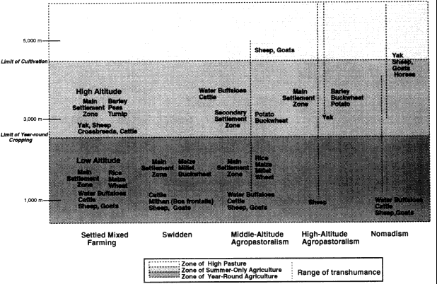
Figure 1.
Land-Use Strategies, Highland Asia
associated patterns of fertilization that may link it to particular types of local pastoralism and forest use. There is an irrigated rice (khet ) production system—or several of them—involving single or multicrop rice cultivation, rice cultivation with winter rain-fed crop rotations, and rice cultivation with winter fallow and grazing of the terraces. There may also be production systems based on irrigated millet. At the same altitude there are also rain-fed (bari ) production systems of various types which emphasize different crops and different types of fertilization, intercropping, relay cropping, double cropping, crop rotations, and fallow periods. There may also be swidden production systems in adjacent forests and woodlands. Some households in the community may make use of a number of these different production systems, each of which involves its own set of land, labor, and capital requirements, local knowledge, institutional resource-management arrangements, relationship to the state in the form of taxes, and involvement or lack of it with a wider market economy. Other households may confine their subsistence strategy to the use of a single production system and find their options limited by social status, wealth, family labor mobilization and talents, knowledge and experience, religious beliefs, or other factors.
Himalayan Subsistence Strategies
The environmental and cultural diversity of the Himalaya and its neighboring ranges has historically supported a diversity of different, adaptive subsistence strategies. At least five broad, traditional subsistence agricultural strategies and several common substrategies can be identified in the central and western Himalaya of Nepal and India alone: settled, mixed farming; swidden agriculture; middle-altitude agropastoralism; high-altitude agropastoralism; and pastoral nomadism (fig. 1).[6] All five have been employed for centuries and continue to be followed today.[7] Today middle- and high-altitude agropastoralism, both of which are based on mixed mountain farming and livestock herding with transhumance, are by far the most widespread adaptive strategies in the mountain regions of Nepal. Settled mixed farming is becoming more common, in part perhaps as a result of agricultural intensification following increasing population density (Boserup 1965), but also as a result of the commercialization of agriculture in response to changes in transportation (especially the expansion of road networks) and the increasing incorporation of formerly more remote areas into a developing national market economy.[8] Historically integral swidden cultivation based on forest fallow rotations was important across large areas of the country and in much of the temperate and subtropical regions remained so into the nineteenth century.[9] Supplementary swidden cultivation continues to
be carried out in a few regions in central and eastern Nepal today despite government efforts to halt it out of concern for forest conditions. True pastoral nomadism, in the sense of an economy entirely based on pastoralism with no crop cultivation whatsoever, is extremely rare in the Himalaya today and is only followed by a very few groups in the western regions of Uttar Pradesh, Himachal Pradesh, and Kashmir.[10]
All of these except for the settled agricultural strategy share an emphasis on directly using resources across a range of altitudes. Although settlement patterns, crop and livestock emphases, and annual rhythms of movement up and down slopes and mountain valleys vary between the different strategies, all of these strategies except settled, mixed farming use seasonal transhumance, movement of livestock, and/or agricultural fields at multiple elevations to exploit land-use opportunities in different microenvironmental regions of the mountains. Trade is also an important mechanism used by peoples of all five patterns to gain goods from other altitudinal and microenvironmental areas of the mountains as well as from regions beyond the mountains.[11]
Middle- and high-altitude agropastoralism vary in settlement emphasis and seasonal altitudinal use. In Nepal the distinguishing characteristic of the two is that middle-altitude agropastoralism is centered on life in main villages situated below 3,000 meters, whereas people following the high-altitude strategy have villages above 3,000 meters. These two strategies differ, however, not only in their emphasis on different types of microenvironmental regions but also in their basic characteristics of crop and livestock production. Groups following the middle-altitude strategy base their crop production below 2,500 meters in country that supports the cultivation of rice, wheat, maize, and millet as staple crops and where year-round crop growing is possible. Their pastoralism tends to revolve around cattle, water buffalo, sheep, and goats that provide a critical source of manure as well as other useful products and that are supported by considerable use of crop residue and forest fodder as well as by seasonal altitudinal shifts of grazing areas, which in some cases include major long-distance shifts of residence to summer alpine pastures. Groups following the high-altitude agropastoral strategy base their agricultural production on sites between 3,000 and 4,500 meters in altitude, generally in inner valleys, partial rain-shadow valleys of the Great Himalaya, and trans-Himalayan valleys that are shielded from the full force of the southwest monsoon. Crops are grown only in the summer at these altitudes and the crop repertoire consists primarily of barley, buckwheat, and tubers. High-altitude pastoralism is based on transhumant herding of yak, cattle-yak crossbreeds, sheep, and goats. These two different altitudinal strategies are complementary. Many groups fol-
lowing the high-altitude pattern carry out trade to obtain grain from middle-altitude groups, offering high-altitude resources such as Tibetan salt and wool in exchange. There is some seasonal overlap in altitudinal use as well. Both strategies make use of seasonal movement between different altitudinal microenvironmental zones. High-altitude groups herd sheep and goats in lower-altitude agricultural areas in winter, in the process also providing valued manure to middle-altitude farmers' fields. Many middle-altitude groups make use of high-altitude pastures for summer herding.
Middle-altitude agropastoralism was apparently long characteristic principally of Hindu Pahari hill-caste villagers in western Nepal and adjacent western India, whose cultural origins and characteristics are closely related to the people of the Ganges plain of India. High-altitude agropastoralism, by contrast, has been practiced almost exclusively by the Buddhist peoples who live on the frontier between India and Tibet and who, as discussed earlier, in many aspects of culture and lifestyle strongly resemble their Tibetan cousins. Many of the peoples of central and eastern Nepal were long distinct from both groups in land use. Gurungs, Tamangs, Rais, and Limbus, for example, were all formerly integral swidden cultivators who relied on rotational systems of shifting agriculture with long forest or bush fallows.[12] Since the late eighteenth century, however, all of these peoples have adopted the distinctive style of transhumance and terrace agriculture of the middle-altitude agropastoral pattern, either abandoning swidden cultivation altogether or employing it only as a supplementary source of food production.[13] In some regions of mountain Nepal, particularly in lower-altitude areas, some Pahari, Tamang, and Magar villagers and communities are now abandoning the seasonal transhumance of the middle-altitude agropastoral strategy for a settled agropastoralism with year-round residence in a single village. In some areas situated near urban settlements and roads this is often associated with new patterns of crop and dairy production developed in response to new market opportunities.[14] Many peoples following the high-altitude agropastoral pattern have also shifted their adaptive strategies into less mobile patterns of pastoralism and trade during the past thirty years. These ongoing changes in lifestyle and land use highlight the need to bring to the analysis of adaptive land-use strategies not only consideration of the environmental setting and role of adaptation to environment and environmental change but also an awareness of the historical context of cultural, social, demographic, technological, and political economic changes and the ways in which these have influenced both household economic decisions and the evolution of cultural patterns of subsistence and adaptation.
Middle-Altitude Mountain Agropastoralism
The middle-altitude agropastoral strategy combines transhumant tending of cattle, water buffalo, sheep and goats with permanent agriculture that is often carried out at multialtitudinal sites. The main focus of crop production is found in the main villages that tend to be located between 1,000 and 2,500 meters. Here terraces are carefully maintained for the cultivation of rice, maize, millet, buckwheat, mustard, vegetables, and winter wheat. Much effort is put into irrigating fields for rice production, and farmers are familiar with techniques of manuring, intercropping, double and relay cropping, and crop rotation. Surrounding forest and woodland areas supply grazing, fodder, and forest-floor litter for fertilizer as well as furnishing fuel wood and lumber. In summer those households that own substantial numbers of cattle and water buffalo often take them up to the rich pastures between 2,500 and 3,000 meters (this is sometimes handled by a single household member or hired herder rather than by the entire family) and sheep and goats may be taken as high as 5,000 meters (again often by specialists). During these weeks herders may live in simple, movable, bamboo shelters, as is common in Nepal, or more substantial herding huts such as are common in the Indian Himalaya west of Nepal (Pant 1935; Berreman 1963a ). Summer herding bases sometimes provide a secondary crop-production site for the cultivation of potatoes and hardy grains such as buckwheat, wheat, and barley. In autumn livestock are led down to the main villages where they graze on field stubble and leave behind manure for the next round of field preparation. In winter the herds may be taken still farther down the valley, where herders again base in temporary shelters or herding huts.[15]
Middle-altitude agropastoral peoples often also participate in complex regional interaltitudinal and trans-Himalayan trade networks. This trade brings the people of the lower-altitude regions salt, wool, seed potatoes, and other valued products from the high valleys and Tibet in exchange for agricultural surpluses grown in the midlands. Mid-altitude-grown grains, especially rice, maize, wheat, and millet, are traded to higher-altitude regions along with some meat, dairy products, and fruits and vegetables. Much of this trade is carried out by high-altitude people who journey down valley in winter and who may make trans-Himalayan spring and autumn trade trips to Tibet. Some middle-altitude groups, however, transport their own agricultural surpluses into higher regions during the late autumn and winter and some middle-altitude farmers also trade agricultural products they have obtained from other middle-and low-altitude areas.
Figures 2 and 3 illustrate the geographic and altitudinal seasonal land-
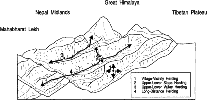
Figure 2.
Middle-Altitude Agropastoralism, Geographic Patterns (Base drawing
adapted from Metz 1989)
use patterns associated with the middle-altitude mountain agropastoral strategy. In them I distinguish four different patterns of seasonal altitudinal and geographical land-use patterns. Two are relatively compressed in both altitudinal and geographical land use, making use of the resources of a single slope. Two are extended in altitudinal and geographical land use, making fuller use of the resources not only of variations in slope but also of longer-distance up and down valley movements. The first of the slope-based patterns is a village-based, relatively settled way of life such as is practiced particularly by groups living in the lower-altitude regions of the Nepal midlands. Here the entire focus is on crop production in the main village with herding and fodder collection from slope areas within easy reach of the settlement. All the other subsistence patterns require seasonal shifts of residence by at least some family members. The second pattern makes use of microenvironmental variation on a single slope, but the distances and relief involved make it necessary for herders to base seasonally in herding huts (goths ) a day or two away from the main village. Cattle, water buffalo, sheep and goats may thus be taken on a limited-distance transhumant migration that may nonetheless cover several thousand meters of altitudinal variation. This movement of only a few kilometers takes them to summer pasture high on the ridge in the temperate forest or even subalpine zone and may also take them to winter pastures below the village in subtropical reaches of the gorge. The third pattern is a longer-distance transhumance in which flocks of sheep and goats and possibly also herds of cattle, crossbreeds, and even water buffalo are taken up valley to summer pastures in the Great Himalaya above 3000 meters. The fourth pattern that traverses
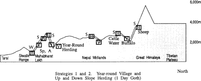
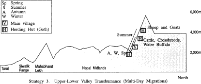
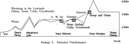
Figure 3
Middle-Altitude Agropastoralism, Altitudinal Patterns
the ranges adds to the third pattern a longer-distance winter move as well, one which takes herders and their sheep, goat, and cattle across the Mahabharat Lekh and out of the midlands into the valleys north of the Siwalik range or even beyond the Siwalik range to its southern alluvial slopes and the Tarai.
In the Dudh Kosi valley and adjacent areas variations of middle-altitude agropastoralism are practiced by Rais, Gurungs, Magars, and several Sherpa groups including the Pharak and Shorung Sherpas. Some of these Sherpa groups have adopted land-use practices that they may have adapted from those of their non-Sherpa neighbors and which from the standpoint of Khumbu Sherpas are quite "un-Sherpa." Some Sherpa families in the Dudh Kosi region, as in the Arun watershed, for example, raise water buffalo and practice swidden cultivation. And in the Arun region some Sherpas even raise pigs and cultivate irrigated rice.
Within the range of microenvironments found in the Nepal midlands and the Great Himalaya between 1,000 and 3,000 meters a great diversity of production systems could be described through which middle-altitude agropastoralists use the resources of particular sites. In the 1,500-2,500-meter altitudinal range in which most of the main villages are located these systems include several different types of production based on rain-fed permanent crops with and without small-scale keeping of cattle, water buffalo, sheep and goats such as year-round cultivation, summer-only cultivation, different types of annual and multiyear crop rotations and fallowing practices, different types of intercropping and relay cropping, food and fodder crops, subsistence and commercial crops. There are also systems based on irrigated agriculture (including rice only and rice followed by winter-irrigated or nonirrigated crops), again with and without associated livestock raising, as well as a number of different types of woodland, forest, grassland use and management. These could be further differentiated on the basis of variations in the use of agricultural inputs (seed, fertilizer, and labor especially), by the social and cultural arrangements influencing crop production, and orientation towards subsistence or commercial production. While this approach would offer valuable insights into land-use techniques and institutions, a fuller understanding of local land use would require both attention to differentiation in wealth, power and other factors that influence household and community resource-use options and decisions and the investigation of the strategies by which particular families, economic classes, communities, and ethnic groups combine sets of these microenvironmentally based production systems into household and regional economies.
Different peoples within the middle-altitude region employ slightly different production systems in very similar microenvironmental sites, and individual ethnic groups make use of more than one system even in similar sites. Crop decisions and rotations, field-fertilization practices, grazing patterns, and other aspects of production systems may vary. Such differences may reflect cultural perceptions (including crop and livestock preferences and religious prohibitions), social arrangements (especially land tenure and communal resource-management institu-
tions), economic differentiation, and political power. There is accordingly no simple equation between given microenvironments and the production systems used in them, although environmental conditions (including altitude, slope, aspect, and the amount, type, timing, and intensity of precipitation) may broadly influence the range of what is and is not rewarding in terms of high yield and low risk.
High-Altitude Mountain Agropastoralism
Above 3,000 meters life is different for the high-altitude-dwelling peoples who make the high valleys of the Great Himalaya and trans-Himalaya their home.[16] At these altitudes crops can only be produced during the summer and generally there is not time enough in the short growing season to cultivate more than a single crop per year of a small number of plants fit for high altitude. The cool temperatures and the risks of late spring, early autumn, and even summer frosts restrict the range of staple crops to barley, buckwheat, wheat, and tubers. Rice, maize, and millet cannot be cultivated and at higher altitudes even wheat production is not possible. Pastoralism is similarly limited in options. The climate is too difficult for water buffalo and cattle may be kept year round at such heights only if much effort is made to stable them and provide them with fodder through the winter months. But yak, yak-cattle crossbreeds, sheep and goats all thrive. Figures 4 and 5 show the geographical and altitudinal land-use patterns associated with variations of the high-altitude mountain agropastoral strategy. As with the middle-altitude agropastoral strategy both extended and compressed strategies are depicted. Extended strategies make greater use of seasonal transhumance, either across the Himalaya to Tibet for winter herding of yak and sheep, down-valley winter herding of sheep, goats, and cattle in the midlands or even the Tarai, or a combination of both of these. The compressed pattern relies on year-round use of the resources of the Great Himalaya alone.
For the past century, and very likely for long before that, peoples following high-altitude agropastoral strategies have usually relied on trade to supplement their crop production. Trade for lower-altitude-grown grains has been particularly important. Until the 1960s many families devoted much of their winter to trading trips to the south in order to barter Tibetan salt and other goods for grain and take advantage of the warmer weather, the readily available food, and the good grazing. Sheep and goats were often taken on these winter journeys as pack animals, whereas families who kept yak left them with herding specialists in the high valleys or sent them across the mountains to Tibet, where the grazing is often better in winter than on the south side of the Himalayan crest
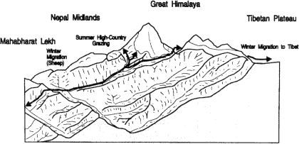
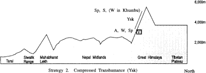
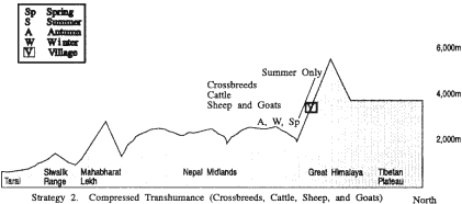
Figure 4.
High-Altitude Agropastoralism, Geographic Patterns (Base drawing
adapted from Metz 1989)
since there is less snow and yak can find abundant grazing on the vast pastures. This way of life, however, is today no longer followed by many Bhotia groups. Political and economic changes in Tibet following the onset of Chinese administration after 1959 have greatly affected trade conditions for Bhotias, as did the 1962 war between China and India and its diplomatic aftermath. Some groups of Bhotias have been unable to continue trans-Himalayan trade on the old scale or to winter stock in Tibet. This has led to major changes in life for Bhotia peoples (see, for example, Fürer-Haimendorf 1975; Rauber 1982). Some have abandoned their former subsistence strategies and migration from the high country and other high-altitude peoples have developed new types of trade or become involved in the tourism industry.
Transhumance is an important feature of the high-altitude agropastoral strategy. After the crops are planted and well established in the main villages families follow the good grass into the upper valleys. Yak and sheep may be herded in mid- and late summer as high as 6,000 meters. Herders usually live in tents, often the black yak-hair tents familiar also in Tibet, moving through a series of different camps in a long-established routine modified to meet the pasture and weather conditions of the particular year. Sometimes additional fields are also cultivated in the summer herding settlements where fine crops of potatoes and barley can be grown even as high as 4,300 meters. Families who continue to trade with Tibet dovetail the demands of the agricultural cycle with one or more trips across the border during the period between spring and late autumn to obtain salt, borax, wool, and other goods for their winter trading in the south.
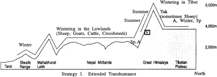
Figure 5.
High-Altitude Agropastoralism, Altitudinal Patterns
Only a few Sherpa groups follow a high-altitude mountain agropastoral strategy, the best known of which are the Sherpas of Khumbu and Rolwaling. The narrow valley of Rolwaling, seven kilometers in length and never more than one kilometer wide, is comparable in altitude to Khumbu. The main village, Beding, is situated at 3,600 meters. Fewer than fifty households inhabit the valley and they prac-
tice a mixed agropastoralism emphasizing transhumant yak herding and multialtitudinal crop production of potatoes and barley. Potatoes and barley are grown as high as the settlement of Na at 4,100 meters. Yak are herded in the summer to above 5,000 meters (Sacherer 1981:157-158). Khumbu Sherpa subsistence strategies are discussed later in this chapter.
Altitudinal Production Zones
Land use at the scale of an entire Himalayan valley such as that of the Dudh Kosi becomes exceedingly complex to analyze at the level of production systems. The range of altitudinal gradients and micro-environmental variation, the diversity of adaptive strategies, and the high level of cultural diversity (in the Dudh Kosi case four different Sherpa groups, at least two Rai groups, as well as Magars and Gurungs) make for a wealth of production systems. This diversity can be simplified at the regional scale for a general overview, however, by considering altitudinal production zones. These constitute broad categories of land use encompassing a number of different, discrete production systems. They narrow the focus of microenvironmental concern to a few broad altitudinal bands identified according to basic regional altitudinal variation in land-use patterns. From this perspective six altitudinal production zones can be discussed in the Dudh Kosi valley (fig. 6) ranging from irrigated and nonirrigated year-round crop production to high-pasture pastoralism. Table 2 shows the current upper altitudinal limits of the staple crops in the valley. Note that Khumbu is situated too high in altitude for the harvest of more than a single summer crop per year and is just out of the current altitudinal range of cultivation of such important Dudh Kosi valley crops as maize and wheat.[17]
Sherpas, Rais, and Gurungs each make use of several zones through middle- and high-altitude agropastoral strategies and in each practice one or more different production systems based on different institutional, cultural, and technical arrangements for raising various types of crops and livestock and exploiting altitudinally related natural resources such as forests, woodlands, and temperate, subalpine, and alpine grasslands and tundra. Within a given altitudinal production zone the choice of cultigens and domestic animals, the scale at which they are raised, and the techniques employed may vary with cultural preferences, religious beliefs, political economy, household status and wealth, and historical processes and events such as the diffusion of terracing techniques, the introduction of new crop varieties, changing trade patterns, and changes in local affluence.[18]
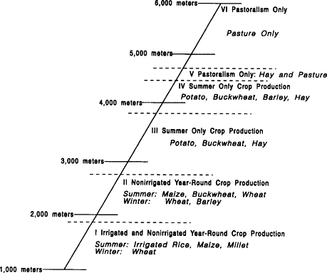
Figure 6.
Dudh Kosi Valley Altitudinal Crop-Production Systems
Table 2 Current Upper Altitudinal Limits of Staple Crops in the Dudh Kosi Valley | ||
Potato | 4,700m | (Tarnak) |
Barley (ua ) | 4,300m | (Dingboche) |
Buckwheat | 4,000m | (Pangboche) |
Barley (jou ) | 2,800m | (Jorsale) |
Wheat | 2,800m | (Jorsale) |
Maize | 2,800m | (Jorsale) |
Millet | 2,000-2,200m | (Kharikhola) |
Rice | 2,000-2,200m | (Bupsa) |
Regional Linkages
Himalayan valleys are typically the homes of a number of different peoples and groups each occupying its own territory and pursuing its own characteristic subsistence strategy or strategies and set of land-use
production systems. These different groups are seldom independent socioeconomic islands and even where there has not been a history of political conflict (conquest, raids, tribute), migration, pilgrimage, or intermarriage there is usually a complex interaction based on trade. It is common also for the dynamics of subsistence strategies themselves to create other types of more direct resource-use interaction. Both the middle-altitude and high-altitude strategies characteristically employ tactics of multialtitudinal land use and seasonal movement between several settlement sites. There is often some overlap in the microenvironmental areas exploited, especially for pastoral patterns. Both middle- and high-altitude agropastoralists value the grazing resources found in the high summer pastures and the lower valley forests, grasslands, and fallowed fields. This sometimes leads to different groups, often of different ethnicities, seasonally making use of the same areas or of crossing other groups' territories en route to their own secondary settlement and grazing areas. To coordinate this multicultural use of particular areas arrangements are made that include joint resource management, user or transit fees, defined common property resource-use boundaries, sequential resource-use arrangements, and other examples of temporal and territorial resource partitioning. In some cases differences in resource-use goals and land-use production systems make it possible to develop complementary multiethnic resource use. A given high-altitude place may be valued as a summer herding area for the sheep and goats of a middle-altitude agropastoral group, for example, and also be an agricultural area for a high-altitude agropastoral group that may value the additional manure provided by the outsiders' sheep. Such complementary resource use is even more common in the altitudinal reaches where middle-altitude main villages are situated. Here middle-altitude households may offer cash and other incentives and compete with each other to obtain better fertilization for their winter fallow fields by having them grazed by the flocks of high-altitude herders who have come down valley for winter grazing. In other cases, however, these same resource activities are seen to compete with local herders' access to pastures, and herding families demand compliance with local grazing restrictions and the payment of grazing fees, or even ban outside herds altogether.
The subsistence strategies and regional resource-use patterns of middle- and high-altitude agropastoralists in the Dudh Kosi valley have historically resulted in a complex pattern of regional trade, seasonal movement, overlapping land use, and resource partitioning and management within a broad general altitudinal differentiation of land use and associated production systems. Rais and Gurungs from the lower reaches of the watershed have taken sheep and goats up into the high pastures, often to their own areas (some of which they retain through claims predating the in-migration of Sherpas), but in other cases to Sherpa-
controlled regions where they have had to follow local grazing regulations and sometimes pay fees. Sherpas from both Khumbu and Pharak formerly took stock (at least on a small scale) into middle-altitude Rai areas, in some cases paying fees for the privilege. In other areas Sherpas have had to pay summer high-altitude grazing fees to Rais. High-altitude Khumbu Sherpas have engaged in trade with both middle-altitude Sherpas and Rais as a basic component of their subsistence economy and both middle-altitude Sherpas and Rais have also long traded to Khumbu. The scale, nature, and geographical extent of this trade, however, has varied enormously over the past century with considerable impact on local subsistence strategies.
Khumbu Sherpa Subsistence Strategies
In many respects Khumbu Sherpa subsistence is a typical high-altitude agropastoral strategy. Like other high Himalayan peoples Khumbu Sherpa have developed an integrated mix of agriculture and pastoralism based on the familiar crops and livestock varieties of the high country. And like other Himalayan peoples in these circumstances they have long supplemented the agricultural and pastoral resources of their high valley homeland by trade geared to obtaining lower-altitude-grown grains. Khumbu Sherpas traded crop surpluses and pastoral products, but they, like many other peoples who live along the Tibetan frontier, have particularly profited from playing a middleman's role transporting goods across the Himalaya between Tibet and the lower lands of Nepal and India. Since the 1960s this trade has dwindled and Sherpas have instead achieved a similar diversification of their subsistence by using cash to buy rice, maize, wheat, millet, and buckwheat grown in the lower Dudh Kosi and adjacent valleys and the Nepalese Tarai. Today, as for at least a century, Khumbu Sherpas do not need to achieve regional or household self-sufficiency in agricultural production. Instead they have the more limited goal of meeting household requirements in a small range of Khumbu staple crops.
Sherpa households' ability to obtain agricultural and pastoral products from regions below 3,000 meters through trade has enabled them to adopt a strategy of specialization in high-altitude-fit varieties of crops and livestock. At the same time, Khumbu Sherpas, like other high-altitude peoples, have made the use of a range of microenvironmental sites a prominent basis of their subsistence strategies. Within Khumbu itself Sherpas make adept use of the minor microenvironmental variations between different sites due to altitude, aspect, precipitation, and soil. Herding strategies for the various types of livestock all involve the
use of seasonal transhumance between lower and higher valley common pastures. Crops are usually planted in fields at a variety of altitudes. Some direct use has also been made of altitudinal and microenvironmental regions beyond Khumbu itself. Sherpas have never developed secondary agricultural areas in lower valley areas remote from their main villages in the way that some Bhotia peoples have in the western Himalaya, but like most other high-altitude peoples they have made use of environmental opportunities in adjacent regions for herding. Earlier in the twentieth century Khumbu Sherpas, like the peoples of Dolpo and Humla in northwestern Nepal, benefited from Tibetan winter pastures and some also took a few crossbreeds and sheep south to the lower valleys to serve as pack stock on trading journeys. In the Khumbu case, however, only a few families did so and then only on a quite small scale. Before the mid-1960s many families, like other Bhotias, devoted the winter to travels which might last five months and which were spent trading and visiting sacred places and shrines.
Since at least the late nineteenth century, and probably for long before, Khumbu subsistence has revolved around the cultivation of a very small number of staple crops which can tolerate the high-altitude conditions. Buckwheat is the main grain, grown in a biannual rotation with tubers. Some barley has also been grown in those few sites where it is possible to easily irrigate the fields, and the need to irrigate barley fields rather than cultural or political economic factors accounts for the distinct lack of emphasis on this preferred food. Formerly, Tibetan varieties of turnip and radish were the staple tuber crops, but during the twentieth century potatoes have become not only the most frequently grown tuber but the dominant crop in the region. Today more than 75 percent of all crop land is in potatoes, usually monocropped and often grown year after year without rotation.[19] Regional diets are today based primarily on potatoes, which are consumed in one form or another as the foundation of virtually every meal. Adult Sherpas typically consume more than a kilogram of the tubers per day, and a family of four requires between one and two metric tons per year for self-sufficiency in this staple.[20] Grain is much less important, and a well-to-do household might live well by local standards on less than 700 kg (10 muri ) per year.[21] Diet varies somewhat with wealth, particularly in the amount of grain consumed. Wealthier families also differ in their choice of grains, and eat rice, barley, and buckwheat rather than the millet, maize, and buckwheat of the poorer households. Rice, maize, and millet are all obtained from outside the region and much higher prices are paid for rice than for the other grains. Recent affluence has greatly increased the amount of rice being consumed today in Khumbu. During the past decade well-to-do families, especially those in Nauje, have also added more processed
foods to their diet. Instant noodles, refined sugar, powdered milk, and even such things as mayonnaise have become popular.[22] Some adverse effects on health and teeth are beginning to become evident.
Over the centuries Khumbu Sherpas have developed a set of different production systems to raise potatoes, buckwheat, and barley. Each makes use of different techniques and requires different knowledge. Some are in use throughout the narrow altitudinal reach of Khumbu whereas others are employed more specifically in a particular type of microenvironmental setting within the region. All of these crop-production systems are also linked with grazing and forest-use practices that furnish crucial field nutrients. Ten different crop-production systems can be identified in Khumbu today, all but two being unirrigated. Nine are based on the cultivation of crops in main terraced fields. The two most important systems in terms of the land devoted to them and the share of local food production which they account for are both unirrigated, single summer crop production systems. In one of these potatoes are grown in a mono-crop for decades with no rotation. In the other there is a two-year rotation between potatoes and buckwheat. Two other production systems that are now employed on a limited basis by a few families in some of the main villages build on these basic potato and buckwheat systems by adding intercrops. In one of these potatoes are intercropped with a Tibetan variety of radish and in the other a semivolunteer called to which produces an edible tuber is encouraged in either potato and buckwheat fields. There are also two production systems now practiced in Nauje which build on potato and buckwheat cultivation through following the main harvest with a second crop. Several families follow potatoes with a second crop of mustard that is grown as a green vegetable, not for its oil. A few families follow potatoes with a second crop of wheat or barley grown for fodder. In both cases the need for the second crop to mature before November limits the use of this system to the lower-altitude settlements of the region and often involves harvesting potatoes before they reach their full maturity in order to make field space available. Two further nonirrigated production systems are devoted to fodder. The most important of these is establishing and tending hay fields. In Nauje there is also some small-scale growing of nonirrigated barley and wheat as fodder crops. Finally, there are two crop-production systems in Khumbu that make use of irrigation. Both are very localized. The most important in terms of the area devoted to it is the cultivation of irrigated barley as a summer field crop. In this system barley is rotated biannually with unirrigated potatoes. The requirements of the agroecosystem for irrigation water in the late spring limit it today to a single site in eastern Khumbu. The other system is the household vegetable garden. Here water is carried by hand from the village water sources to the garden rather than being fed by a canal system
to the site, and is carefully delivered to the plants through hand watering in contrast to the techniques used to irrigate barley.
Agriculture is carried out by nuclear families on privately owned crop and hay fields. Khumbu Sherpas are all smallholders. Most families own less than a quarter hectare of land and wealthy families own little more than half a hectare. The tremendous productivity of potatoes, however, makes even this small amount of land sufficient to meet household requirements in all but the worst years. Indeed, the 1,200 kilograms required by typical Nauje families can be grown on only 600 square meters of land even in a relatively bad year. Elsewhere families have no trouble cultivating enough potatoes for their needs on less than 1,000 square meters of land, and those who own a quarter hectare of land may also reap two muri or more of buckwheat (120 kg), enough for household self-sufficiency in that grain (although far from the ten or more muri of total grain stocks required by a household). In good years families who own only a quarter hectare of land may be able to exchange or sell surplus potatoes or, as is more common, use them as fodder. In some years such a household may also have a surplus of buckwheat. Surplus production is mostly exchanged in Khumbu itself, but throughout the twentieth century dried potatoes have been exported on a very small scale to Tibet and some potatoes have been traded or sold as seed potatoes each January and February to Rais and Sherpas from lower-altitude areas. A relatively small number of families, however, sell potatoes or grain on an annual basis. The great majority of Khumbu families orient their crop production entirely to family consumption. Even the few households that often raise and sell a surplus have had their crop production practices less affected by commercialization than might be expected. These farmers do not, for example, base their decisions about which crops and crop varieties to plant on the basis of market demands and commodity prices. They maintain the same monocrop potato or biannual buckwheat-potato rotations as their fellow villagers, cultivate the same varieties of these crops, and raise them with the same fertilizer and labor inputs.[23]
Pastoralism is based on the care of several species of stock that are hardy enough to winter in Khumbu conditions that are kept for their direct contributions to the family of milk, meat, blood, hair, manure, draft power, and transport and also as sources of income from the sale of calves or their use as pack stock. Yak and especially the female yak, known in Khumbu as nak , are the preferred stock. Cattle, yak-cattle crossbreeds, and sheep are also kept on a small scale.[24] There is a very strong cultural preference for raising yak which is deeply entwined with local conceptions of wealth and status. During the past century the major emphasis in stockkeeping has been on the raising of nak kept both
as a source of milk and for crossbreeding with bulls to produce cross-breed calves that were commercially valuable for sale in Tibet and to middle-altitude Sherpas.
Herding emphasizes the use of the extensive Khumbu rangelands that are regarded as common property resources freely available to all Khumbu Sherpas. The use of some of these areas is regulated during summer by local pastoral management regulations intended to protect growing crops from livestock, reduce pressure on lower Khumbu winter pasture areas, protect areas that furnish wild grass for hay, and establish a form of rotational grazing of some high summer pasture areas. Today all herding is carried out entirely within Khumbu throughout the year. The full range of Khumbu pastoral resources from 2,800 to 6,000 meters is used. Cattle and crossbreeds are herded to high altitudes in summer and in winter are stabled in the lower floor of main village houses and fed fodder. The hardier yak and nak are taken to the very highest Khumbu summer pastures and also often spend much of the winter at high-altitude herding bases where they feed on what grass they can find in the snowy upper valleys and are fed hay that has been grown in nearby walled fields and stored in the high-altitude herding huts. This yak-herding pattern, with its distinctive reliance on year-round use of Khumbu pastures and the consequent importance of winter and spring moves to areas where hay and fodder supplies have been stored, is largely a development of the last sixty years. Previously many yak were taken to Tibet to winter and much less hay was grown in walled fields in Khumbu.[25]
Pastoralism, in contrast to crop growing, is much influenced by commercial concerns and has been for at least a century. Livestock make many contributions to household sustenance, but they are equally as important for many families as sources of income and this affects decisions about herd composition and size. The sale of crossbreed calves bred from nak was long a very important Khumbu industry, although less so in the recent past than formerly. Early in the century it was one of the most lucrative of all Khumbu entrepreneurial avenues. And at various times the keeping of yak and male crossbreeds has reached high levels when it has become especially worthwhile to own pack animals. During the past fifteen years the number of male crossbreeds kept in several Khumbu villages has increased markedly, reflecting interest in opportunities for their use as pack animals in the tourist trade.
Altitudinal Land Use
Khumbu Sherpas make use of a span of vertical environments which ranges from 2,800 to 6,000 meters (fig. 7). Microenvironments within this region vary in climate from cold temperate to arctic and in vegeta-
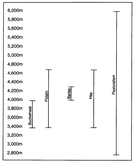
Figure 7.
Khumbu Historical Altitudinal Land Use
tion from temperate forests of pine, fir, birch, rhododendron, and juniper to subalpine forests of fir and rhododendron and high-altitude, alpine shrubland, and from temperate grassland to alpine tundra. Local knowledge of this diversity underlies agricultural and pastoral decisions in everything from terrace siting and crop selection to the timing of planting, the siting of herding huts, and the seasonal movements of
herds of different livestock species. Khumbu Sherpa subsistence strategies emphasize the use of some local microenvironments more than others. The most intensive use is made of the sunny, south- and west-aspect slopes. Here substantial amounts of land even above 4,000 meters have been put into crop terraces and hayfields and considerable grazing is done on other land. Remnant woodlands are much used as sources of forest products, especially as sources of leaves for fertilizer, and they are also often valued as grazing areas. Much less use is made of north- and east-aspect slopes for farming or herding, but the extensive forests below 4,000 meters in these areas have historically been valued sources of timber, roof shakes, and fuel wood. At the higher altitudes the subalpine forest, shrub, and grassland ecosystems and alpine ecosystems of both north- and south-aspect slopes are used for grazing. Below 5,000 meters in these areas much land is also put to the cultivation of hay. Here the difference between sunny and shady aspects is less crucial. The historical emphasis on the use of south- and west-aspect slopes between 3,000 and 4,000 meters has apparently had a role in diminishing the extent of temperate and subalpine forest-woodland ecosystems and in creating the relatively large expanses of shrub and grassland in these zones.
Whereas Khumbu pastoralism, as already mentioned, is carried out through the full vertical range of altitudinal land use, agriculture is conducted in a much narrower range of altitudes. Most crop fields are situated between 3,400 and 4,000 meters with only a relatively small amount of land in higher-altitude fields. Hayfields, by contrast, have been established from 3,400 to as high as 5,000 meters. Multialtitudinal crop production is common. Individual families may own fields that span a thousand meters in elevation. There are four different altitudinal crop zones associated with different types of main and secondary settlements: the gunsa; main village; secondary, high-altitude agricultural site; and the high herding settlement or phu (map 6 and fig. 8). Multialtitude cultivation increases flexibility in labor scheduling, extends the growing season (thus increasing the amount of land that can be cultivated by individual families), expands villagers' access to land beyond the relatively scarce area in the vicinity of most main settlements, and reduces the risks of crop failure by dispersing staple crop production across several different microenvironments. The small altitudinal range between the different crop sites, however, means that no advantage is gained in terms of widening the local crop repertoire beyond buckwheat, barley, and potatoes. Families with gunsa land are able to get an early start on planting potatoes and harvest them before the later-planted, main settlement fields have matured.[26] Generally only a small amount of land is farmed at these altitudes and many families own no gunsa land whatsoever. The main emphasis is on fields in the main village and
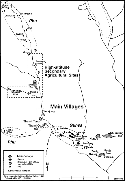
Map 6.
Multialtitudinal Agricultural Sites, Thamicho
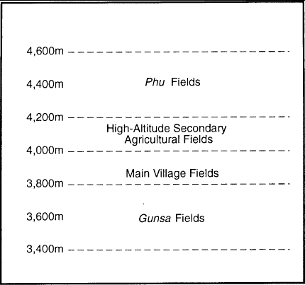
Figure 8.
Thamicho Multialtitudinal Crop Production
especially those immediately adjacent to the house. Most households have well over 50 percent of their total cropland in the main village. High-altitude, secondary agricultural sites are the next most important agricultural zones. Here large amounts of land are put to potatoes, and at Dingboche a roughly equal amount of land is in barley. Formerly buckwheat was also produced in some of these settlements. High-altitude fields above 4,000 meters yield smaller harvests than lower-altitude ones and usually only consist of a small patch or two of potatoes. Harvests at these high herding settlements, however, release families who spend a good part of the year with herds in the high pasture from the effort of transporting as many supplies from the main village.
Distances between gunsa and high-altitude fields may be great enough that in the often rugged terrain a day or more is required to traverse them. Thamicho families with gunsa fields in the lower Bhote Kosi valley at Thamo, for example, may have their highest fields eighteen kilometers up
valley at Chule or Apsona. Some Khumjung, Kunde, and even Nauje families have fields as far away as Dingboche, fifteen kilometers to the east. The distances involved often make cultivating high-altitude, secondary agricultural sites and high herding settlement fields from a single, main village base impractical, and many families shift instead back and forth between dwellings in different reaches of the valley a number of times during the growing season. These movements must also be coordinated with the requirements of herding, community regulations governing the timing of field work and grazing, and social responsibilities at two major summer festivals held in the main village and a third conducted in some high herding settlements.
Integration of Land-Use Activities
Life in Khumbu is a complex integration of the requirements of conducting crop production and pastoralism at the altitudinal limits of both (fig. 9). The use of forest resources is also interwoven with agropastoral-ism as well as making an essential contribution to the provision of fuel and shelter. Agropastoral practices must also be integrated with the seasonal rhythms of conducting long-distance trade and with the required commitments of time and energy for tourism work and business operations. I have not heard of any Khumbu Sherpa family during the twentieth century which specialized in trade to the total exclusion of agriculture, and no Khumbu Sherpa family today relies solely on earnings from tourism. Farming continues to be carried out by all households and ways are found to compensate for the scheduling problems and occasional labor shortages created by the demands of tourism employment. Even the families which have grown wealthiest from trade and tourism continue to place great importance on maintaining the cultivation of their land and many also keep livestock. Some are among the largest stockowners in their villages.
Khumbu crop production is intimately linked to pastoralism even for those families who own little or no livestock. Annual fertilization of potato fields is a fundamental principle of Sherpa agriculture and although everything from composted weeds and forest-floor litter to human waste is used, the most important soil additive is undoubtedly manure. This is so important that the route and timing of herd movements is decided in part on the basis of where household fields are located and when the optimal times are to supply them with manure. Families without sufficient livestock of their own either scour the slopes for dung or devote scarce cash to purchase it--in some places even doing so a year in advance in order to be sure of an adequate supply.
Crop production in turn contributes to pastoralism. Livestock are grazed in autumn on field stubble and fed fodder in winter, which includes
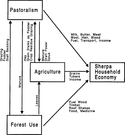
Figure 9.
Khumbu Sherpa Land-Use Integration
carefully dried and stored stalks of buckwheat, barley, and danur , a perennial plant believed to have medicinal and stimulative qualities for cattle. Large amounts of land and labor are devoted to the cultivation of hay that is grown on fields in the lower valleys and in some main villages as well as on a large scale above the range of productive potato cultivation.
Both crop growing and herding are further linked to forest use. Khumbu is at the upper limit of tree growth, and only its sub-4,000-meter, lower reaches support temperate and subalpine forests. Sherpas depend on these limited forest areas for timber and fuel wood and also rely on them for grazing and for soluk , dried leaves and needles scoured from the forest floor.[27] Open woodland in the vicinity of villages provides much-
used grazing and browsing, especially in winter, so much so that its intensity may be affecting forest regeneration in some areas. Forest-floor litter is gathered twice a year and carefully used as stable bedding, after which the urine- and dung-rich material is stored until spring when it is dug into the fields. In some areas and for some families this constitutes a far higher percentage of fertilizer by volume than does manure. The intensity of foraging for leaves and needles gives the forest in the vicinity of villages a freshly swept look and in places every fir needle or birch leaf seems to have been removed. Both the gathering of dead leaves and needles and grazing were permitted even in forests that were traditionally strongly protected by Sherpas from logging or lopping.
Economic Differentiation
The social complexity of indigenous societies has often been neglected or underemphasized in cultural ecological studies. Adaptive strategies and land-use patterns have often been generalized as if regions, settlements, and even individual households maintained the same practices. Yet there may be tremendous variation in household wealth, status, and political power within settlements, as well as contrasts among villages. This may affect lifestyles, types and scale of resource use, land-use practices, access to private and communal land, and the maintenance of local resource-management systems--all of which also can have considerable ramifications for local environmental change. The analysis of local economic and political differentiation may thus be as important an element in the study of environmental degradation as is the examination of the historical impact of national government policies on land use and resource management.
There is not as much differentiation of wealth among Khumbu households as is typical in many parts of Nepal where tremendous disparities in land ownership are common. There is no class of landless Sherpa families or tenant farmers in Khumbu, although there are a few families who own very little land indeed. Nor are there any great estates here like those in some other Sherpa-settled areas such as Shorung and Chyangma. Most families own enough land to harvest a supply of potatoes sufficient for their annual requirements, although in the relatively frequent years of bad harvests they may have some shortfall. No family today owns more than thirty-five head of yak and nak and almost all families, regardless of their wealth, carry out a substantial part of all the labor on their lands.[28] All share the same types of local knowledge of environment and agronomy, the same assumptions about the culturally correct ways of working the land, the same technology and techniques, and the same basic strategies for coping with altitude and Khumbu microenvironments and their
distinctive risks and opportunities. This makes it possible to discuss a "Khumbu Sherpa" pattern of agriculture and of subsistence more generally despite differentiation in wealth. Yet all Khumbu Sherpa families do not uniformly implement the same adaptive land-use strategies and practices. Differences in individual inclination and, to an even more important degree, differences in household labor, land, livestock, and fiscal resources, have led to several different ways of organizing agriculture and pastoralism. Individual families may practice more than one of these over a period of years as their resources change and make possible or impractical different subsistence practices.
Khumbu society has sometimes been regarded by casual visitors as remarkably egalitarian. Yet there are important differences of status, wealth, and power within communities and have been for many generations. There are such differences among Sherpas, between Sherpas and Khambas, and especially between both of these and Khumbu's few families of Hindu blacksmiths. And there are differences in power between ordinary families and those wealthy and powerful families Sherpas refer to as "big people." Differentiation of wealth is clear in diet, amount of fuel wood use, house size, style, and construction materials, and the amount of land and labor they control. It is also clear in subsistence' strategies, not only in stockraising and in some cases in crop selection but also in such small but important things as when crops are planted and harvested and how much manure is put on them. Social differences are thus significant for describing Khumbu land use and exploring possible processes of environmental degradation both before and after the social and economic changes of the 1960s.
The wealthy lived better by Sherpa standards even during the pre-1960 era of "traditional" society. They occupied larger and more luxuriously furnished houses. They owned enough land to produce not only plenty for family consumption but also surplus for sale. If they wanted to raise yak they did, and could afford to maintain the necessary secondary herding huts and hay lands. They could hire sufficient labor to care for their fields and livestock. They had the capital to conduct the most lucrative types of trade with Tibet and to do so without the backbreaking labor of hauling their own loads over the pass. They ate better, being able to afford imported tea and sheep meat from Tibet and rice from lower-altitude Nepal. They dressed better, were better educated, and were better able to accrue merit and social status through support for religion. In many cases they were also the hereditary political leaders and generally had louder voices in village assemblies and in the smaller meetings of village "big people." Formerly there were relatively few such well-to-do families in the region, a disproportionate share of whom lived in Nauje and had acquired their wealth from trade. Tourism has led
to general affluence in the region as compared with both earlier times in Khumbu and current conditions in neighboring regions. This has affected lifestyles and resource use across Khumbu. It has enabled a number of families who formerly were not among the "big people" to gain more local socioeconomic status and political power. Tourism income has not, however, ended regional economic differentiation. Some types of tourism work and business are more lucrative than others and certain families and villages have prospered more than others.
Wealth influences land use primarily through affecting crop-selection decisions. The amount of crop land a family owns is a crucial factor in its decision over whether to cultivate both grains and tubers or only tubers. Although there are some exceptions, most land-poor families tend to emphasize potato production. This tendency is spectacularly visible in the monocrop potato cultivation that has characterized Nauje where crop land has been more limited than in any other main village since the early twentieth century. Wealth may also influence decisions about the variety of potatoes planted, in that rich families can better afford to choose varieties that are highly regarded for their taste even if their yields are inferior to other varieties. Wealth may also affect the amount of manure and other fertilizers which can be worked into fields, since gathering manure tends to be more difficult for households that do not own large numbers of livestock or possess the wealth to purchase manure. Poorer households obviously cannot afford to hire agricultural wage laborers and indeed may have to postpone their own field preparation, planting, weeding, and harvesting if their poverty leads them to work as wage laborers in others' fields. It may not be merely good luck and fine agricultural knowledge that result in some of the wealthiest families in the region also having a reputation as good farmers. They often own some of the best land and can afford to take the best care of it.
Difference in wealth has also been a major factor in variation among households in pastoral practices and in changes through time in herding by individual families. During the past forty years fewer than 50 percent of Khumbu households have kept livestock and fewer still have practiced the yakherding with which Khumbu Sherpas are so identified and which is the local herding preference. There are rather at least four patterns of livestock ownership reflecting different degrees of wealth as well as types of knowledge, skill, and lifestyle preference. These pastoral patterns involve differences in herd structure and size, associated ownership of multiple-altitude herding huts and hay fields, use of hired labor or family labor specialization, patterns of movement in terms of altitude, periods and timing of absence from the home village, and impact on land in terms of areas affected and intensity. They may also lead to differing environmental impacts. Yak and especially nak herding has long been the pre-
ferred form of pastoralism, bringing with it great personal satisfaction in a culture that prizes these animals above all others as well as great social status. But yak and nak herding is a pursuit for relatively well-to-do households, requiring the ownership of high-altitude herding huts and hayfields and either the money to hire leaders or household members willing to take up a relatively difficult and lonely lifestyle for most of the year. The herding of cows and female crossbreeds (zhum ) is primarily carried out by families who own only a few animals and make use of their milk and manure within the household. Male crossbreeds (zopkio ) are the livestock of choice for many families in the lower parts of Khumbu, who are not heavily involved in other stockkeeping and want to invest in animals to be used to earn cash from tourism. The seasonal herding movements, grazing preferences, and fodder requirements of these different types of stock are distinct. The recent regional trend towards more families raising livestock and especially towards the keeping of small numbers of cows and crossbreeds has put greater pressures on some types of pastoral resources, especially on rangelands in lower Khumbu.
Different degrees of household involvement in trade and tourism have also made for enormous differences in cash income and wealth, which have also had repercussions for land use. Such wealth has historically enabled some families to acquire land and livestock, to hire herders, agricultural laborers, and woodcutters, and to consume more non-Khumbu-raised grains, meat, dairy products, and fruits and vegetables. Wealth from trade and tourism has allowed some families, particularly in Nauje and also now in Thamicho, to increasingly specialize their crop production by devoting their relatively small holdings exclusively to potato production. This means that all grain must be purchased.
The Demographic Cycle, Economic Differentiation, and Subsistence
Changing household demographics affect household wealth, resource use and land-use practices in Khumbu as they do in other societies based on subsistence agriculture and pastoralism.[29] Chayanov (1966), in his early work on Russian peasants, was the first to note that household financial and labor resources and economic goals were related to the ages of family members and the rearing of children. He discussed household subsistence economy in terms of a domestic life cycle in which the key factor is the number of producers relative to the number of consumers. This concept of a household demographic cycle has become basic to studies of the domestic mode of production.[30]
According to this view households are more constrained in their labor
resources when children are young and then increasingly improve their capacity for agricultural production as children become older and begin to contribute more labor. Chayanov found that this extra labor capacity was not necessarily, however, fully employed. Once families achieved self-sufficiency in food they tended not to produce surpluses for sale but rather to devote more time to other (often noneconomic) activities. The demographic cycle is significant in Khumbu subsistence today. Sherpas, however, may be more inclined than Chayanov's Russian peasants to channel surplus household labor into profit-making economic activities, including trade, craft production, and tourism development.
It is not yet possible to analyze fully the role of the demographic cycle in Khumbu. At this time the necessary statistical data and the interview-based data on family decisions, the perceived economic utility of children, views on the appropriate work roles of children, inheritance practices, and other key factors are not available. Yet some pertinent observations can be made about the composition of Khumbu households and the relationship between the demographic cycle and subsistence and wealth. Theoretically each Khumbu family passes through this demographic trajectory, each with comparable experiences. In reality, of course, there are major differences due not only to family size and the chronological spacing of children but to luck, skill, inherited resources, and income-earning opportunities. Yet it is worthwhile considering the ways in which the demographic cycle can influence household fortunes and to keep in mind that temporal variation operates at the scale of individual household economies as well as in larger historical and regional settings.
Khumbu Sherpa households are mostly virilocal, nuclear families formed at the time of the completion of the final marriage ritual (zendi ). After this ceremony a man comes into his full inheritance of land and livestock and moves with his wife into a house built for him by his parents in his home village. There are also stem families that result from the custom that the youngest son inherits his parents' house and the responsibility of caring for them in their old age. These stem families consist of the youngest son, his wife and children, and his parents. In cases where a couple has not had any sons another sort of stem household is developed. In this household one daughter remains in the home with her parents after her marriage and is joined there by her husband in an arrangement in which the son-in-law is referred to as a maksu . There are also a very small number of more complex households that are the result of polygynous and polyandrous marriages. In polygynous marriages each wife may be established in a separate house. Polyandrous marriages are usually entered into with two brothers, the spouses sharing a single household. In earlier eras the brothers divided family economic responsibilities, one
often specializing in herding. The establishment of such a household counteracted the usual fragmentation of family land which results from the custom of dividing it equally among the sons. In the 1950s an estimated 8 percent of Khumbu Sherpa households were polyandrous (Fürer-Haimendorf 1964:68). This has greatly declined, however, and none has been established as far as I know within the past fifteen years.
Households are largely economically independent. Communities enforce some resource-use regulations, particularly for pasture and forest use, but otherwise seldom interfere in household decisions about subsistence practices and land use. Much agricultural work is carried out by reciprocal work teams formed by groups of women friends, but relatively little cooperative labor is organized by clans, lineages, or extended families. Kin are called on to assist in difficult times and for such major efforts as housebuilding, at which time a careful ledger is kept of contributions of materials, money, and labor so that this can be reciprocated when the occasion arises. Wage laborers are also employed by those households who have the means for everything from crop production to building, weaving, and household tasks.
The Khumbu demographic cycle begins at the time of the establishment of the household after the zendi ceremony. Sons, who until this time have contributed their labor to their parents' household, now inherit their share of land and livestock and establish their own households. The youngest son remains a part of his parents' household and gradually takes control of the house and land, the parents working with him as long as they are physically able to. This stem family generally stays together until it is dissolved by the death of the parents.[31] Occasionally an elderly couple decides not to remain as a part of their son's household and instead establishes itself in one of the family's gunsa or secondary, high-altitude agricultural site houses. Some old people go into religious retreat after their children's marriages and build a house for this purpose in a quiet place nearby the village or at the Tengboche monastery.
Young couples normally already have one and often two children at the time that they establish their own household. This reflects Sherpa cultural patterns of courtship and marriage, which involve a series of rituals and increasing commitments conducted over a period of years (see Fürer-Haimendorf 1979) during which time the prospective husband openly visits his fiancée at her parents' home and spends nights with her. Khumbu families thus begin their operation as a household with dependents. During the next few years additional children are usually born, and although infant and child mortality rates are high the family often increases to five or six members. During this first stage of the demographic cycle the number of consumers is high relative to the number of producers, since one pair of adults must care for several
children. In this situation either agriculture production must be increased (e.g., by the expenditure of relatively high amounts of labor to increase yields by more careful and time-consuming manuring and weeding) or more wage income must be made to purchase food. In this stage of the demographic cycle there is considerable pressure on both the young parents, on men to make income for food purchases and on women to grow as much food as possible for the family as well as to care for infants. Today men work for wages in the tourist trade. Formerly they might have attempted to profit through trade or, if all else failed, may have emigrated with the hope of returning with more capital.
A second stage in the demographic cycle begins when the oldest child reaches the age of five to seven. Even at this early age children begin to contribute to the household economy and cease to be merely consumers. Young children care for still younger ones, freeing mothers for other tasks. Some play at gathering manure, forest leaves, and water with diminutive baskets and carrying jugs. By the age of ten children are contributing significantly to household labor. Boys gather water, dead wood, and manure and take animals out in the morning and bring them back in the evening following instructions given by their fathers. Girls haul water, cook, perform other housework, gather manure and forest leaves from nearby slopes, and sometimes help with the livestock. Many girls have already dropped out of school by this age and thus have considerable time to help out with household responsibilities. By the age of thirteen to fifteen both boys and girls are usually performing nearly a full adult share of household labor during school vacations (if they remain in school at all) as well as working before or after school. Even at the age of twelve some strong girls handle an adult's share of agricultural work and represent their family in reciprocal labor groups. By the time they reach fifteen years of age many boys do the full work of an adult and some even go trekking by the time they are thirteen to fifteen. By twenty all young people are performing full adult work for their families. Sons who begin wage labor in tourism donate their full salary to the household. The ratio of producers to consumers thus begins to change as the children grow older and does so much faster than in the Russian peasant families with whom Chayanov worked. Because the eldest child is usually one to three years old at the time the household is established the family begins in only a few years to escape from the early pressure on the adult couple to support and care for the entire household.[32]
Khumbu Sherpas today marry relatively late, usually not until after age twenty-five. Young men and women are expected to contribute their full labor to the household until the time that they marry and leave it and also to turn over wage earnings to the family. This means that the Sherpa household typically matures into an economic unit of four or more producers and remains together for a number of years after the children
have reached adulthood. During this time there are opportunities for considerable increase in family wealth. Older males can be freed from herding responsibilities by younger ones and devote more time to wage earning in tourism, or the family may build up a larger herd now that it has the hands to care for it. The family women may be able to farm their own family land without participating in a reciprocal labor group or hiring wage laborers, and they may also engage in some wage-earning activities such as operating a lodge or shop or producing handicrafts for the tourist industry. And rather than depending on a single income from a tourism-related job the family may now profit from several, for the sons may contribute a decade or more of earnings to the family welfare. During this time the family may expand its land holdings and (more frequently) its livestock ownership, and may accumulate more capital for trade ventures or entry into the lodge or shop business. As children become engaged (the demchang ceremony is usually held three or four years before the final zendi marriage ceremony) the family labor situation may change slightly as young men begin to contribute some of their time to helping their fiancée's family with its herding, even to the extent of taking pack stock trekking and giving the income from this to the young woman's family. They help out in this way from six months or a year after the demchang engagement to the time of the marriage.[33] In some cases there is some reciprocity, and young women help their fiancée's families when asked to.
The family enters another stage as the children begin to marry. As sons wed and leave home they take with them an equal share of the land and livestock; daughters carry with them a dowry of cash, jewelry, and household possessions. The wealth a household has accumulated during the past twenty-five or more years begins to be fragmented, and seldom are the sons of wealthy men themselves wealthy simply through inheritance. If the sons share a wife in a polyandrous marriage this fragmentation is avoided. It may also be minimized if there is no son and a son-in-law is adopted into the family lineage and given the family house and property. In most cases, however, the nuclear family ultimately fragments.
A stem family in which a parental couple share a house with their youngest son and his daughter often has labor resources that are superior to those of the new nuclear families of the older brothers, for the parents may remain economically active for many years. The aging parental couple continues to work, and in former eras might still be major traders well into their 60s and 70s as well as sharing in the fieldwork and herding. Some men and women continue to make major income from the tourist trade into their later years, especially from operating lodges and shops. The stem family of the youngest son may ultimately be burdened more than advantaged, however, if the parents' health declines and they require much support in their old age.
3
Farming on the Roof of the World
Khumbu crop production matches Sherpa knowledge and ingenuity against the limited range of possibilities and the adverse conditions of their homeland. The variety of crops that can be grown is severely constrained by the short growing season at altitudes of more than 3,000 meters and even the most altitudinally fit crops are at great risk due to frost, untimely rains, and crop pests and diseases. Sherpas bring to this challenge many generations of experience with the microenvironmental conditions of each Khumbu agricultural site and considerable knowledge of the characteristics, requirements, and capabilities of the crops from which they live. Sherpas manage to cope successfully with the risks and limitations of high-altitude agriculture by basing their farming on local knowledge of both microenvironments and the performance of cultigens in them. They consider Khumbu not so much a hard place to survive as country where good harvests reward good farmers except in the worst years. Yet for all their care they nevertheless experience frequent poor harvests. Entire crops of buckwheat can be lost, and as often as one year out of three the potato harvest is likely to be at least a third poorer than in a good year.[1]
The pattern of agriculture in Khumbu in terms of which land is cultivated and which crops are grown in it represents the decisions of both today's farmers and the cultural and physical capital which they have inherited from those who worked the land before them. Khumbu farming today reflects continuity of knowledge and practices across many generations. Virtually all the terraces farmed today were created more than a half century ago and many are much older. The long maintenance
of these terraces, the long and careful attention to maintaining and building soil fertility, and the many long-standing practices in crop selection and care all testify to continuity in farming. Agriculture has not, however, been a static art. There have been many changes in agricultural techniques and emphases even during the past century, as I will discuss in chapter 6. But the fundamental basis of Khumbu agriculture and the local knowledge that underlies it remain strongly based on cultural patterns developed earlier in the twentieth century and preceding eras, patterns of perception and land use which Sherpas have in part evolved out of the experience of life in Khumbu and which are attuned to the place, its seasonal rhythms, its climatic hazards, its topography, and its soil.
In this chapter I explore twentieth-century Khumbu Sherpa agriculture and its basis in environmental adaptation. Here I look particularly at the selection of particular crops and crop varieties for specific altitudes and sites, the use of multialtitudinal fields, and the fine-tuned agricultural calendar that is followed for different crops at particular localities. I also discuss other factors that affect agricultural practices and the annual cycle of crop growing, from the social organization of production, economic differentiation, and state policies to religious beliefs and efforts to enhance farming luck.
Altitude, Terrain, Climate, and Soil: Perception and Farming
Sherpa perception, categorization, and evaluation of microenvironments greatly influence their selection of crop sites and choice of crops and crop varieties. Especially important are the differences that are distinguished between soil types, precipitation patterns, and agricultural growing seasons. More than 97 percent of Khumbu is considered unsuitable for cultivation due to altitude, aspect, poor soil conditions, or excessive precipitation. Most of the remaining potentially arable land has never been put into cultivation and remains today in forest, woodland, and grassland. The amount of land that is actually in fields is far less than 1 percent of the total area of Khumbu, and nearly 20 percent of this small area, moreover, is in hay.
The preferred areas for crop production have an altitude of less than 4,100 meters, a south or west aspect for maximum daily sunlight during the short summer growing season, level or gently sloping sites, and loam or sand-loam soils. Although potatoes can be raised as high as 4,700 meters, almost no land is planted with them above 4,300 meters. The major centers of crop production, with the exception of Dingboche, are all located between 3,400 and 4,100 meters. Below 3,800 meters virtu-
ally every bit of relatively flat or gently-sloped land with a south aspect has long been claimed for agriculture.[2] Alluvial terraces, hanging valleys, and former lake beds at these lower altitudes are tightly patterned with small, stone-wall-girded, rectangular fields. Where adjacent slopes are only moderately steep these have often been carved into flights of terraces that may sweep across slopes in staircased tiers spanning up to 200 vertical meters of elevation. Terraced fields tend to be narrow and small; fields of 300-400 square meters are common and many are smaller still. Only on the rare level expanses are there larger fields, some of which are as much as 1,500 square meters in size. Considerable effort has gone into the creation of these terraces, for each is built with stone risers (tsigpa ) and stone walls are also usually raised around the individual fields to protect them from livestock.[3] Most are constructed on relatively gentle slopes of less than ten degrees, although in some localities slopes of twenty degrees have been terraced.
Soil type and quality are major concerns of farmers and the focus of a great deal of labor to maintain and enhance. Regional soils vary with altitude, geomorphic and vegetative cover history, and the underlying country rock from which they have developed. The region is not blessed with exceptionally fertile soils. Most have developed relatively recently from gneissic and granitic parent material. The alpine soils of the high valleys are generally quite recent and thin, having developed in reaches of the region which were affected by glacial processes during the not-distant past. These are primarily entisols and are often less than sixty-five centimeters in depth. Below 4,000 meters spodosols have developed in extensive areas that are or were forested with a mixed fir, birch, and rhododendron subalpine and temperate forest, especially on northern-aspect slopes. The extensive grassland and shrubland areas that now cover large areas of southern-aspect slopes below 3,750 meters have inceptisol and entisol soils (Byers 1987c:210).[4] Land currently in terraces was presumably claimed for crop land from areas that were previously grassland or historically cleared forest and woodland. Some important agricultural sites, however, including Thami Og, Thami Teng, Yulajung, Tarnga, parts of Khumjung, and Dingboche, are also located on sandy, nutrient-poor, former lake sites and alluvial terraces.
Sherpas have developed a body of knowledge and techniques concerned with evaluating and conditioning soils. They discriminate between several soil types on the basis of color and texture and use this categorization in assessing land value and deciding on appropriate crop selection and manuring for fields (table 3). Across Khumbu the preferred soil is sa nakpu , literally "black soil." This is the black, humus-rich loam common in main fields in the villages and also in some outlying areas where care has been taken to provide plentiful manure. Black soil
Table 3 . Khumbu Soil Types and Characteristics | ||
Name | Local Defining Characteristic | Evaluation |
Sa Nakpu | black, neither sandy nor clay | excellent |
Sa Seru | yellow, more sand | good |
Pemi Sa | sandy | fair for potato |
Dambak Seru | yellow clay | poor |
Dambak Nakpu | black clay | poor |
is the product of generations of effort and assiduous application of manure and other fertilizers, and indeed the soil color of village fields reflects well their manuring history and generally varies strikingly between fields adjacent to the house and those at the edges of the settlement. More common than black soil is sa seru , "yellow soil," less rich in humus and usually higher in sand content. Though generally considered to be less desirable, it can yield good potato harvests if adequate manure is applied. Sherpas point to the high potato yields of some fields in Thami Og, Tarnga, Phurtse, and Khumjung as an indication that yellow soil can be productive.
Several other soils are less highly regarded. These are pemi sa , "sandy soil," and dambak seru , "yellow clay soil." Sandy soil areas are not necessarily shunned for agriculture and can produce good potatoes when properly manured. Some areas of conspicuously sandy soils in the Bhote Kosi valley produce potatoes renowned for both taste and yields. Yellow clay soil, however, is considered hopelessly poor. Black clay soil is nearly as bad. A few fields in Khumjung, Thami Og, and Phurtse have black clay soil and they are considered to produce sparse, stunted crops of buckwheat and subnormal yields of potato. There are also some clay soil fields in small areas of Dingboche, Pangboche, and minor sites such as Nyeshe near Nauje. All of them are considered to be very unproductive.[5]
The general characteristics of Khumbu climate have already been introduced in chapter 1. From the standpoint of crop production, microclimate variation on a much more intimate scale becomes important. Temperature and precipitation vary within the region with altitude and topographic situation, giving Khumbu a rich variety of microclimates. Sherpas believe that climatic conditions within Khumbu vary nearly as much as soil conditions. They identify differences in precipitation among valleys, precipitation and temperature differences between lower valleys and upper valleys, and high rainfall pockets in certain areas within valleys. The Bhote Kosi valley is considered to be drier than either the Dudh Kosi or Imja Khola valleys. Areas above 4,000 meters are considered to be drier than lower-altitude areas. Some places such as Pulubuk
and Nakdingog in eastern Khumbu are notoriously rainy and are considered unsuitable for cultivation. Differences are recognized in some cases between the microclimates of places that are scarcely a kilometer apart and these perceptions influence decisions about the extent and timing of crop planting. Precipitation is one factor here, but temperature and frost patterns are even more important. The role of aspect in microclimate is recognized, and shaded slopes are usually shunned as crop sites. Altitude is also considered to affect both precipitation and temperature and is taken into account in the selection of crops and crop varieties for particular sites.
Sherpas have developed a large body of knowledge about climatic threats to crops. Particular crop areas known to be susceptible to particular types of climatic problems and particular crops and crop varieties have reputations for being at different types of risk in different parts of Khumbu. This knowledge is reflected in local planting schedules and cultivation practices, as well as in religious and other protective measures.
Frost (se ) is the most common climatic risk across Khumbu. It is a major spring problem throughout the region, and unusual freezing conditions in early autumn can devastate buckwheat crops.[6] The severity of risk to crops can be judged from the frequency of frost-diminished harvests during the last few years and the extent of damage. Between 1981 and 1987 frost caused major crop loss in some main villages three times.[7] One farmer from Thami Teng explained that frost affected crops there in most years, although the amount of crop damage varied considerably from year to year. A single night's frost during these critical spring weeks can lower potato harvests by a third and cause such striking damage to buckwheat fields that many farmers replant entire fields.[8]
The greatest risk from frost to both potato and buckwheat is usually in April and May. At low-altitude sites (in Nauje and in gunsa) April frosts are the main problem and are rare in the following month. For the other main villages and the phu there is greater danger in May. Here April frosts are no threat due to the later date of planting. In the phu frost danger continues even into July and begins again in late summer. Often there will be several days of frost in succession.[9] Farmers recognize that early planting increases the risk of frost damage, but planting cannot be delayed long at altitudes with such a short growing season. Planting potatoes later will yield smaller tubers at harvest time. And the later that buckwheat is planted the smaller the crop is likely to be, for with later harvests comes greater danger from early snows. A heavy September snow can wreak havoc with buckwheat in the higher settlements. Such a snow in 1968 caused great damage to Pangboche and Phurtse buckwheat despite the villagers' emergency harvest efforts.
Frost problems are considered to occur most often when a clear night
follows a rainy spring afternoon. The 1986 frost, for example, was described by a Nauje man as coming on the full moon of the fourth Sherpa lunar month, Dawa Shiwa (generally in May), when after a rainy afternoon the night was clear. That frost affected crops in the Bhote Kosi valley from Tarnga to Phurte, and also damaged crops in Pangboche, Phurtse, Khumjung, and Kunde. Heavy frost can overnight transform fields that were green with young crops into brown, withered plots of shriveled yellow and black plants resembling, as a Khumjung woman put it, "dry tobacco leaves." Although frost damage is usually associated simply with unfortunate weather conditions many Sherpas believe that these can be triggered by human actions. A particularly bad frost in 1981 in the main Thamicho settlements, for example, is said to have been caused by an improperly performed crop-protection ceremony. On the very night that the annual rite of circumambulation of the fields was performed a severe frost caused considerable damage. The ritual circumambulation has not been performed since.[10]
Some farmers believe that certain crops in a given place are more affected by frost than others. In Phurtse one woman, for example, contended that differences in soil may influence losses from frost or the lack of them. She noted that buckwheat grown on good black soil produces a harvest even when it is hit by repeated frosts whereas crops on drier yellow soil at the edge of the village yield little under those conditions. Other farmers have suggested that different varieties of a single crop may respond differently to frost conditions. Some elderly Sherpas recall that one type of potato grown early in this century was much less vulnerable to frost than another popular variety. Some people say that there are differences in the frost hardiness of two of the common varieties grown today. They suggest that the red potato may be more vulnerable to frost than the yellow potato since it develops a stalk earlier, but note that even the red potato usually survives a single frost. It is also said, however, that the yellow potato flowers earlier and thus suffers more from frost than other potato varieties.
Untimely rains are also considered to be a major agricultural problem. Rainfall varies from year to year in timing and intensity. Drought is not considered a major hazard. A delayed monsoon can result in poor crops, especially in the earlier-planted gunsa fields, but no major crop failures due to drought are remembered. A greater regional problem is an overabundance of rain that can lead to poor crops in the main villages.[11] The greatest risks result from intense multiday rains. According to Sherpas there are two such intense rainfall periods in Khumbu. Yerchu , "summer rain," is a July-August (Dawa Tukpa-Dawa Dimba ) rain that lasts five to seven days. Sherpas describe it as a period in which the cloud ceiling is unusually high and the sky atypically light, but during
which very heavy rain falls. Tenju , "autumn rain," is a very heavy September-early October (Dawa Gepa-Guwa ) rain that lasts up to a week (although some people say that it lasts only two to four days). Both are rare and may fall only once or twice in a decade.[12]
Yerchu rains are usually not a problem for crops, although some Sherpas feel that they can cause buckwheat to develop large stalks and leaves but produce rather poor seed. It is also possible that in unusually moist summers there is more risk of accelerated spread of fungal blight (shimbak ). Tenju rains, however, can cause considerable damage. Terrace walls occasionally buckle following such storms, and in the spectacular 1968 case so much runoff occurred that two houses were damaged in Nauje and many villagers abandoned their homes and spent a night huddled with their most prized belongings beside the supposed protective influence of the main shrine (chorten) of the village. The same storm caused much damage to buckwheat in Pangboche and Phurtse. Tenju rains are said to have destroyed buckwheat at Pangboche and to have also damaged Dingboche barley. Autumn rains are not considered a threat to potatoes, but they can cause damage to harvests by seeping into open potato-storage pits and rotting the stored potatoes. Autumn rains of any scale, of course, can also cause havoc with hay making.
Besides their familiarity with local soil, climate, and weather Sherpas also bring to their farming a keen sense of other environmental risks to crops. Foraging mammals and birds (including Himalayan tahr (Hemitragus jemlahicus ), Impeyan pheasants, choughs, and in lower Khumbu—although rarely today—bears and monkeys) can cause crop losses. Certain places in Khumbu are well known for the frequency of their crop losses to particular types of wildlife.[13] The destructive potential of livestock is also recognized, and hence the long-standing practice of banishing stock from villages (and also from some secondary crop-growing areas) during the height of the growing season. A yak or crossbreed can graze a buckwheat or barley field to ruin in a few hours. Livestock are said to damage potatoes even in the final weeks before they are harvested since their trampling causes the tubers to rot below ground. There are no serious insect problems, by contrast, although farmers in the lowest-altitude areas of Khumbu sometimes lose some potato plants to a worm that severs the stalks.
Plant diseases are of much more concern. Khumbu potatoes are affected both by late blight and warts, and blight is also said to infect buckwheat and barley[14] The greatest problem is shimbak or late blight (Phytophthora infestans ), the fungal disease that was responsible for the Irish potato famine of 1846-47.[15] Late blight is a major problem today in most of the potato-producing areas of the Himalaya.[16] Khumbu communities have taken extraordinary precautions in attempts to stave off the
onset and spread of blight, believing that by observing a set of bans on activities believed to affect the well-being of plants that they could prevent the outbreak of the disease or limit its impact.
The leaves of potato plants that have been affected by blight wither and blacken as early as June. The blight is usually at its height in July and August (Dawa Tukpa to Dawa Dimba).[17] Entire Khumbu valleys can be swept by blight and in bad years crop losses can be as much as 50 percent. Throughout the twentieth century blight has been a continuing problem. Serious infestations typically occur several times per decade. In recent years there have been problems in 1983, 1987, and 1990.
Some people believe that heavy rain can encourage the outbreak of blight, particularly when it falls in late May or early June (Dawa Nawa ). Sherpas also believe that blight can be transmitted by human or livestock contact with plants during the summer and hence communities have banned farmers from entering the fields from late June or early July until harvest and have also banished livestock from the villages during this period.[18] There are also a number of other restrictions that were once carefully observed in the villages and enforced by village officials. These included bans on bringing freshly cut timber, fuel wood, or bamboo into the settlement, construction work, drying herbs and leaves outdoors, or firing guns. These various antiblight regulations are not observed by Sherpas in Shorung and other areas and may have been unique to Khumbu.
The importance of keeping stock away from the maturing village crops in order to protect them from blight is taken very seriously. In Khumjung and Kunde, where this ban is enacted soon after the Dumje festival, some people predicted that there would be trouble with blight in 1987 because Dumje was scheduled to be held late that year due to an unusual counting of the months in the Sherpa calendar to avoid an astrologically inauspicious condition. Within those villages there was much debate over whether Dumje should be held as customary at the beginning of the fifth lunar month in order to be able to close the village to livestock as usual in June rather than in July. Konchok Chombi was concerned that "there will be blight if we wait until then to get livestock and people away from the fields." Such advice was not heeded and that summer the blight was the worst it had been for many years.
The viral disease Synchytrium endobioticum (Sherpa kongsur re, ze shur re , or ne zakpa ), often called potato wart, is a problem in much of eastern Nepal and other areas where Darjeeling varieties of potatoes are cultivated. The disease causes crusty, scab-like areas on the potato skin, and infected potatoes can rot. Once the virus infects an area it can become established in the soil and is difficult to eradicate, and it is capable of destroying entire crops. In Khumbu the problem is especially
severe at Dingboche where some people associate it with the unique emphasis on fertilizing fields with juniper needles, suggesting that this alters the soil in a way that leads to the onset of the disease. Infected potatoes also occur in other communities, however, where juniper needles are not used as fertilizer. When the problem is discovered at harvest time the usual practice is to separate infected tubers from the rest of the harvest. These tubers are then consumed first before they deteriorate further. It is considered to be very important not to mix wart-infected potatoes with good ones in the storage pits, for it is thought that the infection can spread to previously unaffected tubers.[19]
Specialization and Diversification: Crop Selection and Multialtitudinal Fields
Both specialization and diversification can be defenses against disaster in areas of high agricultural risks. Risk can be appreciably lowered by specializing in crops and crop varieties that have been found to be particularly fit for local conditions. In some parts of the world farmers even deliberately select relatively low-yielding crops and varieties to plant rather than others with which they are familiar because they are likely to give some yield even in the worst expected conditions. Diversification may also be an effective risk-minimization strategy. Diversity can be achieved in a number of ways. At the level of the individual field farmers may plant a variety of crops and varieties rather than a monocrop. Thus five types of rice, not a single one, might be planted in a field, or several different types of maize might be grown intercropped with millets. Multicropped fields provide a buffer against risks as a result of the different climate, insect, and disease tolerances and resistances of different varieties. They may also decrease the spread of disease and provide barriers to the dispersal of species-specific insects. At a higher level of the farming strategy a household might choose to plant a number of different crops in their various fields rather than to emphasize a single staple. This prevents disaster when a particular crop is laid to waste by disease, avoiding a catastrophe such as the Irish potato famine that was based on overreliance on a single crop. A household may also choose to cultivate a given staple in plots at a number of different locations with different microenvironmental conditions rather than only in the main village. By doing so they may well avoid loosing everything to drought, heavy storm, frost, hail, or disease even when these devastate some sites. The heavy rain that destroys a crop in one part of the valley may never fall in another area nearby. And a farming family can also reduce risk at a still broader level by diversifying their household economy to
avoid the need to achieve self-sufficiency in food production. This can be done in many ways, from devoting some of their land and labor to producing cash crops and other agricultural products to engaging in nonfarm labor and other enterprises.
Khumbu Sherpas employ subsistence strategies that emphasize both specialization and diversification. They specialize in the most productive crops for high Himalayan conditions (potatoes, buckwheat, and barley) and have emphasized potatoes, the most productive of all, to a highly unusual degree. They have a somewhat narrow scope for diversification in the severe microclimates of their homeland, but they do practice some forms of it. Formerly families generally cultivated several staple crops, including a set of different tubers rather than simply potatoes, and despite the increasing monoculture of potatoes today many families continue to cultivate both grains and tubers. Although farmers may emphasize one or two varieties of potatoes, they commonly grow several others as well and are well aware of their altitudinal fitness, climate hardiness, and disease resistance. Some people intercrop radishes with potatoes. Typically families cultivate fields at a number of different sites around the village and many also produce crops at more distant sites at different altitudes. And Sherpas have also long integrated agriculture into a broader economic base which frees them from a need to depend solely on Khumbu harvests for sustenance.
Multialtitudinal crop production is a risk-minimization strategy shared by many mountain peoples. Poor crop-growing conditions at one site, such as drought, excess rain, crop disease, or insect pests, may not affect other sites with different microclimates in the same way, diminishing the risks of crop failure at any particular site. Good yields in some sites may compensate for poor ones in others. Multialtitudinal crop growing is a basic feature of agriculture for many (although far from all) Khumbu families. It is common to plant potatoes in fields at a number of different elevations in gunsas, main villages, secondary high-altitude, and high-herding settlements. Farmers testify that yields at different altitudinal sites often vary considerably from year to year. A late monsoon that may seriously affect the earliest-planted potato fields of the gunsa settlements may foster bumper crops in secondary high-altitude fields planted a month later. A year of higher than normal rainfall such as occurred in 1990 may support unusually fine crops in the relatively drier upper valleys while lower valley crops do poorly. The frost which affects low-altitude crops in May may not touch higher-altitude crops that have not yet germinated. Microclimatic conditions and crop performance may also vary in these cases among fields at the same altitude but on different sides of a valley. Differences in the amount of sunlight received at these sites influences soil temperature and available soil moisture.[20] The de-
gree of steepness of slopes can also be an important factor in soil moisture conditions.
Multialtitudinal crop production also has several other advantages. Labor can be scheduled across a longer agricultural season than would be the case if only main village fields were cultivated (Fürer-Haimendorf 1975:28).[21] Planting potatoes in the high-altitude herding settlements saves the trouble of transporting the quantities of food to those places from the main villages that would otherwise be necessary. And a family that has not been able to acquire enough crop land in the main village area where land is often scarce and too expensive to meet its needs may find that higher valley land is their only alternative. Many Nauje families have bought land in Bhote Kosi valley secondary high-altitude agricultural sites over the last decade for this reason.
Despite the multiple benefits of multialtitudinal crop production most families do not farm fields in the full range of altitudinal sites. Most have land in several sites in the main village and its immediate vicinity and in one of the major, secondary, high-altitude agricultural sites. Most Thamicho families also own gunsa lands, but this is not common today in the other villages and only a small percentage of families has crop fields in the high-herding settlements.[22] The bulk of most families' harvest comes from main village fields. Usually well over half of a family's harvest (often 75 percent or more) comes from main village fields. A family that owns less than 25 percent of its cropland at different altitudes generally cannot hope to compensate fully for a poor harvest year in the main village. The relatively great concentration on main village farming today may, however, have been largely a twentieth-century development. In the nineteenth century, when the Khumbu population was much smaller and before the introduction of higher-yielding varieties of potatoes, it may have been more typical both to have more total land per household in cultivation and for these holdings to be more evenly distributed altitudinally.
Khumbu Crops
The range of crops that can be cultivated at Khumbu altitudes is limited to a rather small number of Himalayan staples. As was discussed in the previous chapter, even the lowest Khumbu villages and gunsa are too high in altitude for the cultivation of wheat and maize and are well over 1,000 meters above the highest-altitude Dudh Kosi valley sites where rice and millet are cultivated.[23] Khumbu Sherpas have accordingly long based their farming on high-altitude-fit buckwheat, barley, and tubers. No green vegetables are grown as field crops. Small amounts of mustard (pezu ) are grown in household gardens for their green leafs and
Table 4 . Khumbu Crops | |||
Common Name | Sherpa Name | Nepali Name | Latin Name |
Barley | na | ua | Hordeum vulgare |
Buckwheat | tou | tito phapar | Fagopyrum tataricum |
Potato | riki | alu | Solanum tuberosum |
Radish | lo | mula | Raphanus sativus |
Turnip | tulu | salegam | Brassica rapa |
Mustard | pezu | rayo saag | Brassica juncea |
Garlic | gokpa | lasun | Allium sativum |
Jerusalem artichoke | ge riki | gane suryamukhi | Helianthus tuberosus |
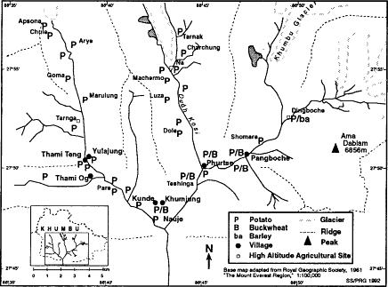
Map 7.
Crop Patterns, 1987
several types of garlic (gokpa ) and chives are grown in window pots and gardens. Recently a few families have begun growing cabbage, carrots, and cauliflower in garden plots in some of the lower settlements.[24] Fruit growing is still less important. Although several families have attempted to raise apple trees it has not yet proved possible to produce fruit in Khumbu. The current regional distribution of crops is shown in map 7.
Grains
Buckwheat is today the most important grain grown in Khumbu in terms of the amount of land planted to it and its place in the regional diet. Sherpas, like Tibetans, esteem barley far beyond buckwheat as a food and barley is equally as altitudinally fit for Khumbu conditions. Yet barley is grown only on a very small scale in Khumbu, probably due to the need to irrigate it in May and early June and the scarcity of easily irrigatable sites. Buckwheat cultivation requires no irrigation, and formerly it was grown in all the main villages and in the high-altitude, secondary, agricultural site of Tarnga. Today it is grown in half of the main villages of the region.[25] Barley, by contrast, has since the early twentieth century been cultivated only in the high-altitude Imja Khola settlement of Dingboche (4,300m). This is one of the highest altitudes at which grain production has been reported in the Himalaya or Tibet. Buckwheat is today cultivated as high as 4,000 meters in Pangboche and was formerly grown at a similar altitude at Tarnga in the Bhote Kosi valley (table 5).
The Khumbu varieties of both buckwheat and barley are Tibetan varieties. The barley grown at Dingboche is a naked black barley known in Sherpa as na (Nepali ua ). This is grown on a small scale in the neighboring Tingri region of Tibet. It is quite distinct both from the bearded white barley grown in Pharak (Nepali jou ) and from the white barley which is the staple in Tingri.[26] Khumbu buckwheat is the Tibetan variety, Tartary buckwheat (Fagopyrum tataricum ) that is known in Nepali as "bitter buckwheat" in contrast to the "good-tasting buckwheat" (Fagopyrum esculentum ) of the lower altitudes. The latter variety is the buckwheat most familiar worldwide. The Tibetan variety, however, is able to withstand cooler temperatures better and Sherpas consider it the only one fit for Khumbu conditions. In Khumbu two varieties of the Tibetan type are cultivated, one white and one black. The white variety is by far the most common. In neighboring Pharak, however, the black variety predominates.
Both buckwheat and barley are rotated with tubers in a two-year sequence. A field devoted to grain one summer is planted in potatoes the next spring. Barley has the longer growing season and is planted in the first days of April, six or more weeks earlier than buckwheat. It is also harvested earlier, in late September rather than in early or mid-October as buckwheat is. The two crops also vary considerably in the care they require. Buckwheat flourishes on relatively nutrient-poor soils and without any irrigation. It alone of all the Khumbu crops is normally not fertilized. Barley, by contrast, is very carefully fertilized and is the only irrigated Khumbu crop.[27]
Table 5 . Historical Altitude Ranges of Khumbu Crops | ||
Lowest Altitude Grown | Highest Altitude Grown | |
Grains: | ||
Barley | ||
(white) | 4,050m (Tarnga only) | |
(black) | 4,380m (Dingboche only) | 4,380m (Dingboche only) |
Buckwheat | 3,400m (Nyeshe) | 4,050m (Tarnga) |
3,985m (Pangboche) | ||
Maize | 2,800m (Jangdingma) | 2,800m (Jangdingma) |
Wheat | 3,400m (Tashilung) | 3,400m (Tashilung) |
Tubers: | ||
Potato | 3,400m (Nyeshe) | 4,690m (Tarnak) |
4,753m (Chukkung) | ||
Radish | 3,400m (Nyeshe) | 4,380m (Dingboche) |
Turnip | 3,400m (Nyeshe) | 4,480m (Chulungmasur) |
Jerusalem artichoke | 3,400m (Tashilung) | 3,600m (Samde) |
Other crops: | ||
Peas | 3,440m (Nauje) | 4,050m (Tarnga) |
Rayo sag | 3,440m (Nauje) | 4,753m (Chukkung) |
Garlic | 3,440m (Nauje) | 4,753m (Chukkung) |
The special treatment devoted to barley reflects the high value that Sherpas place on it as a food. It is also considered to be suitable for use in religious ceremonies and offerings. Fields at Dingboche that yield good barley crops are considered especially valuable property and ownership of them is cause for pride. Although most of the fields of Dingboche belong to families from the nearby village of Pangboche there are also fields owned by Khumjung, Kunde, and even Nauje households. It is extremely difficult to purchase such a field for owners seldom offer them for sale. Indeed, even to be offered the chance to buy Dingboche barley from a family that may have a surplus is considered to be a mark of friendship and favor. In the early twentieth century there was so much concern over the quality of barley harvests that Sherpas hesitated to plant less spiritually pure crops such as buckwheat and potatoes in the same settlement where barley was cultivated for fear of offending the barley crop and losing the harvest. It was only in the twentieth century that this self-imposed ban was broken at Dingboche. Barley is also the only Khumbu crop that is associated directly with divinity: there is a local god of barley whose seat is the beautiful barley-grain-shaped snow peak of Cho Polu that overlooks the barley fields of Dingboche. Buckwheat has no such religious associations but is instead
regarded as an inauspicious grain that can be used ritually only to hurl at ghosts in an effort to drive them off. Puffed buckwheat can also be used in a ceremony to appease feared spirits (saptok ) who dwell in boulders. Even white buckwheat is inauspicious, for the shape more than the color of the grain is the issue. Buckwheat grains have three sides, a number which is considered very unlucky by Khumbu Sherpas.[28]
Buckwheat is ground into flour and eaten as a thick porridge (sen ) and as an unleavened, chapati -like flatbread. Barley is processed into tsampa , the distinctive staple food prized throughout the Tibetan culture region. Tsampa is a flour produced through a multiday process of soaking, drying, and finally popping barley grains in a pan of heated sand held over an open outdoor fire and then grinding the puffed barley into a flour in a water mill. Sherpas eat tsampa in three forms. It can be mixed with salt-butter tea as a porridge (chamdur ), kneaded with a small amount of tea into a paste (pak ), or thrown dry by the spoonful down the throat (chamgagyou ). Sherpas treasure the uniquely rich taste of tsampa and take great pains to produce and procure the best quality. Villagers perceive enormous differences in tsampa depending on the care with which it is made and on the type and source of the barley used. Black barley tsampa has a different color and taste from that of white barley, and in Khumbu Sherpas' judgement the best quality tsampa requires that dark Dingboche barley must be mixed with small amounts of Pharak-grown white barley. Black Dingboche barley is widely considered in Khumbu to have a more superior taste than that imported from Tibet or Pharak.[29]
Pangboche villagers note that buckwheat grown there has yields similar to Dingboche barley. Yields, of course, vary enormously from year to year due to the high susceptibility of grain crops to damage from bad weather and livestock. The return on the volume of grain planted as seed is from four to eight times.[30] A Dingboche barleyfield of 1,500 square meters planted with ten pathi (approximately twenty-six kilograms of seed) may yield four muri (approximately 9.6 bushels and 208 kilograms of grain at 52 kg/muri) in a superb year. Two to three muri is more typical. In the best of conditions, yields are thus only 0.14 kilograms per square meter on large barley fields at Dingboche. In Pangboche some fields produce as much as 0.7 kilograms per square meter of buckwheat in the best of years. But even this is a meagre harvest in comparison to the two to four kilograms per square meter common for potato cultivation across Khumbu. Few families own enough grain land to harvest more than a few muri per year. In 1987 five Pangboche families averaged 1.65 muri each of buckwheat production and to this could be added another two muri of barley—well under the ten to fifteen muri of grain typically consumed by Khumbu households. These figures reveal the continuing Khumbu need for obtaining substantial stocks of lower-altitude-grown grain.
Tubers
Khumbu Sherpas have emphasized the cultivation of tubers as well as of grains since at least the late nineteenth century and very possibly for considerably longer. For a hundred years or more tubers have very likely been grown on half or more of Khumbu crop land and during the twentieth century they have increasingly dominated Khumbu agriculture. Four tubers are planted: potato, radish, turnip, and Jerusalem artichoke. A fifth, which Sherpas call to , is harvested as a wild semicultivate.[31] The potato (riki ) is today the most important by far of these, and is indeed the primary Khumbu crop. Although the other tubers are raised only on a quite minor scale today, they were more important in regional agriculture before the 1930s. The white, turnip-like, Tibetan variety of radish (lo ) that is grown as high as 4,000 meters has long been a valued food and fodder crop and was once even dried for sale to nearby Rais. Today it is a minor crop grown only as an intercrop in a few potato fields. The Tibetan variety of turnip (tulu ) was a field crop in the early twentieth century, but today is only grown in a few gardens. Jerusalem artichoke (ge riki ) is cultivated only in a few fields in Bhote Kosi-valley gunsa by families who use it to produce a particularly potent alcohol.
The potato is by far the most important crop today in Khumbu. It is cultivated from the lowest gunsa to the highest herding settlements where crops are planted and flourishes as high as 4,700 meters. More than 75 percent of all land in food crops is in potatoes. In half the villages of Khumbu it is the sole food crop grown and in the others it is grown on 50 percent or more of the crop area. Potatoes dominate crop production at higher altitudes. Except in Dingboche they are the only food crop in the secondary, high-altitude agricultural sites and the high-herding settlements. Even in many gunsa they are today the only crop raised. Nearly all of this production is for Khumbu consumption and the potato is the central staple of Khumbu household sustenance.
No food in Khumbu is as basic as the potato. Potatoes form the basis of virtually every meal and almost every dish. Even the most common snack is a bowl of boiled potatoes. Most potatoes are eaten boiled, served in their skins (which diners then peel and discard) and dipped in salt or hot pepper, yoghurt, and garlic sauces.[32] Potato pancakes (riki kur ) are popular, prepared by grating uncooked potatoes on a ribbed slab of stone, mixing these in a batter with buckwheat flour, and then cooking the pancakes on a flat slab of slate over a wood fire and serving them with nak butter and yoghurt sauces. A form of mashed potatoes (rildok sen ) served with bowls of a sharp cheese soup is also popular. Potatoes usually are the main ingredient of stew (shakpa ) and potato curry is the most common accompaniment to rice. They are also distilled
into alcohol, sun dried for use in stews or for trade to Tibet, and are made into a flour (riki karruk ) through a process of mashing, drying and stone-grinding.
The degree to which Khumbu Sherpa agriculture is today based on potatoes is probably unique in the Himalaya. Elsewhere it is more common to emphasize grains as much as or more than tubers and to grow other tubers besides potatoes. There is no simple climatic or edaphic explanation for why the peoples of high-altitude central and northwestern Nepal, including those of Mustang, Dolpo, Mugu, and Karnali base their agriculture on the cultivation of barley, wheat, and buckwheat more than on tubers and often emphasize the cultivation of Tibetan varieties of radish more than potato. Potatoes would very probably be well suited to these regions. Their lack of importance may reflect better conditions for cultivating irrigated grain crops in these regions as well as a possibly later date of potato introduction and diffusion.[33] The strong Khumbu Sherpa emphasis on potatoes, however, reflect many factors other than the region's relatively poor irrigation possibilities and longer familiarity with the crop. Local interest in agricultural intensification apparently played a key role in the historical process of focusing Khumbu agriculture around monocultured potatoes. The process took several generations to develop and is discussed in chapter 6.
Today at least nine varieties of potatoes are grown in Khumbu, and during the twentieth century Khumbu Sherpas have introduced at least fifteen varieties (table 6).[34] Sherpas have named local potato varieties primarily on the basis of their color, although other qualities such as shape and even assumed source of introduction can be used, as can be seen in table 6. Varietal names can differ among valleys, villages, and households. Black and brown potatoes, for example, are considered by some Sherpas to refer to the same variety. The name "English potato" is used by some farmers for tubers also known by other people as kyuma and koru ; kyuma is also known as hati .
Sherpas have developed considerable familiarity with the characteristics and performance of the different potato varieties they have introduced, experimented with, and retained as part of their crop repertoire. They categorize potato varieties on the basis of tuber size, tuber skin and flesh color, flower color, leaf size, hue and growing patterns, and growing season, as well as on local evaluations of their taste, yield, altitude fitness, disease resistance, intercropping capabilities and storage qualities. Their evaluation of the performance of the various varieties includes rating them in these various characteristics at specific altitudes and in particular agricultural sites. There is a widely shared conventional knowledge about long-familiar varieties and much discussion and exchange of insights about experiences with new varieties. Women also
Table 6 . Khumbu Potato Varieties | ||
Sherpa Name | English Name | Characteristics |
Riki moru[*] | red | red skin, pink flower |
Riki seru[*] | yellow | yellow flesh, white flower |
Riki bikasi[*] | development | red flesh, large tuber, purple flower |
Riki mukpu[*] | brown | black/red/brown skin, purple flower |
Riki nakpu[*] | black | black/red/brown skin, purple flower |
Riki ngamaringbu[*] | long tail | white and pink flower |
Riki linge | watery | |
Riki belati | English | refers to several varieties |
Riki koru | round | small, white tubers |
Riki koru (2) | round | yellowish flesh, pink flower |
Riki kyuma (hati)[*] | elephant | long, white/yellow flesh, white flower |
Riki anka kali[*] | black eye | riki moru (?) with darker eyes |
Riki nyungma | long, slightly redder than kyuma | |
Riki ngumbu | very watery, poor taste | |
Riki madangshe[*] | similar to anka kali | |
* Currently grown in Khumbu | ||
often exchange small amounts of seed potatoes so that their friends, relatives, and neighbors can test new types for themselves in their own fields. There is special concern with altitudinal suitability, climatic hardiness, productivity, taste, disease resistance, storage qualities, and fodder value. Each household reaches its own conclusions about the varieties it prefers to plant on its lands, for although there is usually a good deal of agreement about particular varieties' characteristics the way in which households weigh the relative importance of criteria varies. For some households it may matter a great deal how well a variety is rated as fodder whereas for others this may not be a factor. In recent years concern with yield and altitudinal fitness have tended to outweigh all other factors for most families. The relatively high-yielding yellow and so-called development potatoes have been widely adopted despite considerable shortcomings in some other criteria, including a poor regard for their taste.
Taste, however, is of some importance in cropping decisions, as is the production of potato varieties that are considered to be good for specific culinary purposes. A people consuming as many potatoes as Khumbu Sherpas do and for whom the tuber figures in very nearly every meal might be expected to have a well-developed appreciation of varietal variation in taste. Red potatoes are widely considered to be the finest tasting (skakindi ) of currently grown Khumbu varieties and are used in
all potato preparations. They are especially preferred for preparing boiled potatoes, the dish where the taste and texture of the tuber is most savored. Yellow potatoes are less well regarded, although their generally larger size makes them especially useful for dishes that require grinding tubers, such as potato pancakes and mashed potatoes. Some potato varieties have been briefly experimented with and rejected due to poor taste. Riki nyumbu , which gained a reputation for being watery and poor tasting (shalindi ), was one of these. Many people also decided that it was bad for their health after word spread that it caused stomach pain and intestinal problems. Many families initially balked at planting the yellow potato due to reservations about its taste. As with nyumbu there were also some complaints of stomach problems associated with eating it and several Sherpas also questioned the yellow potato's nutritional qualities. One person insisted, for example, that a single load of red potatoes is worth two of yellow potatoes in terms of food value. A number of these families have since decided nonetheless to plant yellow potatoes, ultimately deciding that their high yields, better disease resistance, and good storage qualities outweighed other factors. A similar process of initial rejection on taste and health grounds and subsequent gradual reevaluation has occurred with most recently introduced high-yielding varieties of development potatoes.
Three varieties are particularly important today, the red potato (riki moru ), the yellow potato (riki seru ), and the development potato (riki bikasi ). Red potatoes in Khumbu are similar in size and shape to the red potatoes familiar today in the U.S. They have red-hued skins and a generally round form, and the tubers are typically apple-sized or smaller. The red potato has been grown in Khumbu since the 1930s and was obtained from Sikkim. Yellow potato tubers are more oblong and often much larger than red potatoes, with a lighter-hued skin and slightly yellow flesh. They are neither our russet potato nor white potato although they are often similar to the former in size and shape. The yellow potato was only introduced to Khumbu in the mid-1970s from Darjeeling and from north-central Nepal, but within a few years it had become the most commonly grown variety in spite of its poorly regarded taste due to its high yields. The tubers of the development potato are large and thin-skinned, with a deeper red skin and flesh than any other Khumbu variety. They have the longest growing season of any potato grown in Khumbu, a characteristic that at first was thought by many to be a considerable drawback before interest in its high yields overcame this and other early objections to it. It is the most recently introduced of the set of Khumbu potato varieties and was brought to Khumbu by Nauje Sherpas who found it at a Shorung government agricultural station only in 1981.[35]
Historically the relative importance of Khumbu varieties has changed considerably. The red potato, which was the staple variety throughout the region from the 1930s until the late 1970s, is considered to be the best-tasting Khumbu potato and remains the primary variety grown at high altitudes. By 1987 it had been nearly totally supplanted, however, at altitudes lower than 4,000 meters by the far higher-yielding yellow potato and the development potato, and by 1990 it was losing ground to these even in the settlements at higher altitudes. During much of the 1980s the yellow potato was the mainstay of Khumbu potato production through most of the region, not only producing a much higher total yield than the red potato but also being planted on more land. The development potato has been widely experimented with and adopted by farmers in much of lower- and mid-altitude Khumbu during the past five years, however, and it now appears likely to replace the yellow potato as the region's main variety despite earlier local reservations about its hardiness and suitability for cultivation at high altitudes due to its longer growing season. The original introduction of the potato to Khumbu and the subsequent introduction, adoption, and diffusion of other varieties in the twentieth century figure prominently in the history of Khumbu agropastoralism, the subject of chapter 6.
Yield
Khumbu farmers have strong views about the productivity of potato varieties. They believe that, in general, Khumbu is a good region for potato cultivation and that yields in some parts of Khumbu, especially the Bhote Kosi valley, are excellent in comparison with those in other areas of Nepal with which they are acquainted. Contrasts are drawn between the productivity of different sites, especially on the grounds of altitude (a topic which is taken up in the following section). And farmers consider that the different varieties have very different average yields. The potatoes of the early part of the century, kyuma and koru, are widely remembered, for example, as being relatively low-yielding in comparison with those varieties that have been the staples since the 1930s. Of the early varieties kyuma was considered better yielding than koru, but many farmers recall that it yielded less than half as much as the red potato does. When the yellow potato was first being cultivated in Khumbu in the mid-1970s farmers reported yields that were quadruple or more that of red potatoes. This contrast has decreased in recent years, but double and triple yields are common at the altitude of the main villages. The development potato has been found to yield triple or quadruple the yield of the yellow potato in the main villages, making it by far the most productive variety in the region.
Estimates of potato productivity vary, of course, from farmer to farmer and place to place. At Pangboche the return on one load of red potato seed tubers is said by one farmer there to be about four loads, with a similar return at Dingboche. Two Khumjung farmers, by contrast, report returns of six to eleven loads per planted load in good years and a return of fifteen loads in the best of years. Yellow potato yields are considerably higher even at 4,000 meters when the gap between yellow and red potatoes begins to narrow. At Pangboche, for example, a load of planted yellow potatoes is considered to yield about eight loads in autumn as compared to four of red potatoes. At Nauje in good years the rate of return on yellow potatoes is about ten to one, and in such years most families could harvest enough to live on from planting only two-and-a-half loads. In Khumjung one highly successful farming family reports yields of fourteen loads of yellow potatoes per planted load in average years and a twenty-five-to-one ratio for the best years.
Variations in yields from year to year can be enormous. Many farmers report a range of up to 300 percent between extremely bad years and good ones in terms of the total number of loads harvested. Others note a similar variation in different terms, pointing out that whereas in some years a single worker is able to harvest three loads of potatoes in a day in other years three people working together cannot harvest a single load in a day. This degree of variability is described for both red and yellow potatoes, and earlier varieties are remembered as being even more prone to bad years.
There is also a widespread belief that yields of particular varieties have declined through time. Kyuma, red potatoes, and yellow potatoes are each said to have yielded larger crops during their first years of cultivation than in later years. Sherpas do not attribute this decline to loss of soil fertility or to a gradual loss of a particular variety's disease resistance or other characteristics. Instead they believe that old varieties become dispirited and lose their vitality and will to produce when farmers begin planting new potato varieties in their fields. People note that kyuma yields declined after the introduction of the red potato and that red potato yields did the same after yellow potatoes began to be cultivated. Some Sherpas are now saying that yellow potato yields are beginning to decline and they relate this to the adoption of the development potato. Beliefs about this process seldom deter people from adopting new varieties. One Dingboche-based family, however, did decide not to plant yellow potatoes for a number of years for fear that planting them would cause the disappearance of the red potato. They only began planting the new variety after being assured by the abbot of Tengboche monastery that the fate of the red potato at Dingboche would not be affected by a single family's honoring it by refusing to plant yellow
potatoes. Within a few years the family converted its Dingboche cropping entirely to yellow potatoes.
Field measurements of Khumbu potato yields had not been done prior to 1987. That year I attempted to carry out measurements of crop yields at a number of different agricultural sites. This proved to be a complex endeavor. One complication was the fact that harvests occurred simultaneously in the different valleys and at many different sites and altitudes. Another, more serious factor was that many people were uncomfortable with the prospect of their harvest being measured. By enlisting the help of several of my Sherpa assistants and friends in different villages I was able to collect data on yields in eighty-two potato fields in five different agricultural sites: Nauje (seventeen fields), Thami Og (thirty-seven fields), Tarnga (six fields), Pangboche (thirteen fields), and Dingboche (nine fields). In each field three one-square-meter plots were randomly chosen and marked. All the tubers within these areas were then dug and weighed and the yields totaled and averaged. Except for a few fields at Nauje and those at Tarnga, a total of eight fields, all fields in which measurements were carried out were main fields adjacent to dwellings. Such fields are almost always well-manured and carefully cultivated and they are generally the most productive of a family's holdings. There were major contrasts in yields. Average yields in the main villages ranged from 1.5 kilograms per square meter at Pangboche to 3.8 at Thami Og. Nauje had an average yield of 2.2 kilograms per square meter. The yields at the two higher-altitude, secondary agricultural sites differed still more: Tarnga, with 4.8 kilograms per square meter, had the highest average yield of any of the sites, whereas Dingboche, with 0.9, had the lowest. These yields were much affected by the severe blight of 1987 that struck fields in some settlements more than others. Yields in Nauje were much lower than normal due to widespread blight damage. Pangboche also experienced some problem with blight, although much less than Nauje. Harvests in the other locations were minimally affected by blight and are more typical of a good year's crop.
These potato yields are quite high by national standards. They bear out not only the general perception that yields are good in the region but also that they are especially good in the Bhote Kosi valley. The average yield for main fields measured was 2.8 kilograms per square meter, or 28 metric tons per hectare. This is far above the Nepal national average of 6.25 tons per hectare (Khanal 1988:27).[36] Such extraordinarily high figures may reflect a number of factors. Potatoes are intensively grown in Khumbu, and may be better fertilized, more carefully cultivated, and more closely spaced than in many other areas. They are grown here as a summer rather than a winter crop as they are in some of the country. At Khumbu altitudes there may be less damage from some types of insects
and other pests. Disease losses may also be less. Although blight and warts are certainly factors in Khumbu there may well be less loss from these and other viral diseases than in lower, warmer, and moister areas. The moderate rainfall levels and sandy loam soils of Khumbu may be particularly good for potatoes.[37] Tubers stored for spring planting material may winter more viably and disease-free in the cooler climate than in lower areas.[38] And finally, aggregate national figures may be low due to underreporting or underestimating of harvests as well as poor-yielding areas lowering the average.[39]
The 1987 field measurements also give some support to Sherpa evaluations of the varying productivity of different varieties at given altitudes. Here the data are quite limited, for of the eighty-two main fields that we were able to measure only twenty-nine were planted in a single variety of potatoes, twenty-one in yellow and eight in red potatoes. Varietal yield comparisons from the other fields are not possible since in those fields Sherpas had mixed the seed tubers of a number of varieties before planting. Twenty-five fields were planted with evenly mixed yellow and red potatoes and the remainder in various other combinations of yellow, red, development, brown, and, in a few Nauje fields, a local variety called ngamaringbu . The small number of fields in single variety cultivation makes comparisons of the relative productivity of different varieties difficult. While the contrasts are suggestive, the small sample size means that these findings can obviously not be given much weight. The yellow potato slightly outyielded the red potato at Nauje (2.6kg/m2 to 2.0kg/m2 ) and Pangboche (1.39kg/m2 to 1.33kg/m2 ). At Dingboche yellow potato yields were considerably lower (.89kg/m2 ) and roughly equal to those of red potatoes (.91kg/m2 ).[40] Altitudinal differences in yields are suggested by these figures, but the Bhote Kosi valley figures serve to caution against a simple equation between altitude and yield. Yields at Tarnga (4,050m), for example, were quite high. All fields measured there produced yields comparable to the best Thami Og fields and better than the highest-yielding fields in other sites. Tarnga is famous for both the yield and the taste of its potatoes and the great contrasts between yields there and at Dingboche, which has a reputation for poor yields, accorded well with Sherpa assessments of the productivity of potato cultivation at these sites.
The average yield of 2.8 kilograms per square meter from the eighty-two fields in which measurements were obtained suggests that Sherpas can achieve household potato self-sufficiency on very little crop land. This yield can be taken to represent a far lower than average year's productivity, for more than two-thirds of the fields that were sampled had been infected by blight. For Nauje households, which typically require at least twenty-five loads (1,200kg) of potatoes per year, only 600
square meters (.06ha) of crop land planted with perhaps four or five loads of mixed yellow, red, and development seed potatoes would be sufficient for family needs even in a poor year that yielded only two kilograms per square meter. This is the equivalent of only two small Nauje terraces. A household in one of the villages where potatoes are a higher percentage of the diet might require somewhat more land, but for producing forty loads (1,920kg) of potatoes at even two kilograms per square meter only 960 square meters would suffice. In average or good years even these small farms would produce a substantial surplus that most households would normally devote to fodder for their cattle.
Altitude and Varietal Performance
The performance of a given potato variety is considered to vary with altitude in a number of key criteria including yield, frost vulnerability, and taste. Some varieties perform relatively well across the full altitudinal range of Khumbu potato cropping, whereas others are not considered suitable for fields above 4,000 meters. Those with longer growing seasons are much more vulnerable to frosts at high altitudes and tend to have much lower yields even when they are not damaged by spring frosts, perhaps reflecting reduced tuber development when the harvest is carried out in late summer or early autumn. It is also believed that at high altitudes some varieties become less tasty, and farmers may forgo planting them even if their yield would be acceptable.
The red potato and the brown potato are considered to be the most altitudinally hardy of Khumbu potato varieties and are the most widely grown at altitudes of 4,200 meters and above (table 7). The brown potato is only grown in the Bhote Kosi valley on any significant scale, but it is the main potato of its upper reaches from Tarnga to Apsona.[41] Red potatoes are also grown as high as Apsona and are the potato of choice in the highest fields in the Dudh Kosi where fields are cultivated as high as Tarnak (4,690m); a small patch of these tubers was harvested for several years in the upper Imja Khola valley at Chukkung (4,753m). In the Dudh Kosi valley only the red potato is grown in the settlements above 4,000 meters. The yellow potato, which by far outproduces the red one at the altitude of the main villages, has a relatively long growing season and is considered by many farmers to therefore be unsuitable for fields above 4,000 meters.[42] At that altitude yellow potato yields are also considered to decline, and some people also consider that its taste begins to deteriorate. According to some Thamicho villagers yellow potatoes become more watery when grown at a higher altitude. This same view is expressed by many Dudh Kosi valley farmers and some Pangboche residents consider yellow potatoes too watery to plant not only at Ding-
Table 7 . Altitude and Potato Cultivation, 1987 | |||
Bhote Kosi Valley | Dudh Kosi Valley | Imja Khola Valley | |
4,400m | brown , red | red | red , yellow |
4,200m | brown , red | red | red , yellow |
4,000m | yellow , red, brown | red | yellow , red |
3,800m | yellow , red, development | yellow , red | yellow , red |
3,400m | yellow , red, development | yellow , red, development | |
NOTE: Italics indicate the most widely cultivated variety in a valley at a given altitudinal range. | |||
boche but in Pangboche itself. Very few families grow the yellow potato in any of the agricultural sites above Phurtse. At Na, for example, only two of the twenty-three families with potato fields grow any yellow potatoes. No one plants yellow potatoes in Machermo and Panga, sites of comparable altitude on the west side of the Dudh Kosi.[43]
It is widely perceived that yields of both red and yellow potatoes decline above 4,000 meters, although at some sites, such as Tarnga, yields of both can be quite good even at this altitude. Although potatoes are planted in the upper Dudh Kosi valley nearly to 4,700 meters, this is very unusual in Khumbu and in general there is almost no potato cultivation above 4,300 meters. This no doubt primarily reflects an assessment of the likely diminishing returns and greater risk of such extremely high-altitude potato production. Other factors, however, may also be involved, including the lack of a need for large amounts of potatoes in the high-altitude herding settlements, sufficient agricultural opportunities at lower altitudes for meeting main village subsistence requirements, and lack of interest in producing greater potato surpluses for sale. There may also be concern that it is much more difficult to protect crops from depredations by livestock in high-altitude areas that are prime summer grazing ground.
Only a few years ago the development potato was considered to have the narrowest range of altitudinal fitness. When it was first introduced a number of people doubted that it would be an important variety at altitudes very much higher than that of Nauje due to its extremely long growing season. As recently as 1987 cultivation had only been attempted as high as Thami Teng and Yulajung (3,800m), and there was only undertaken on a very small scale and with mixed evaluations. At that time the variety was not considered suitable at altitudes higher than 3,800 meters. By 1990, however, it was being grown widely at Tarnga (4,050m) where it produced quite good yields, and it had also been introduced to Dingboche.
Other Factors in Varietal Selection
Sherpas also evaluate several other qualities in making decisions about which varieties of potatoes to plant at specific sites. The most important are their perception of disease resistance, storage quality, and fodder suitability. Potato varieties are considered to vary considerably in their degree of resistance to disease. Old potato varieties all had a bad reputation for being blight-susceptible. So did the red potato. For some years Sherpas felt that the yellow potato was relatively blight-resistant and that even if the plant was affected early in the summer its "stronger" leaves and stalk enabled it to produce larger tubers than blight-infected red potatoes would. This opinion was probably widely revised after 1987 when yellow as well as red potatoes suffered major blight damage in Nauje and the lower Bhote Kosi valley. Both yellow and red potato harvests were small. Development potatoes, on the other hand, went noticeably unscathed and fields in this variety flourished on through September surrounded by fields in yellow and red potatoes that had withered by late July.
How long and well potatoes can be stored is an extremely critical quality given their year-round role in the Khumbu diet. Potatoes are stored in outdoor, underground storage pits (miktung ) to keep them the longest possible time, and some varieties tend to spoil in these conditions more than others. The red potato has a poor storage reputation. People point out that if a single red potato tuber goes bad in a storage pit it is likely to affect all the others stored there. It is not unheard of for pits to be opened in the spring and for no potatoes to be salvageable from them. The yellow potato, by contrast, has an excellent reputation.[44] Although I have heard of cases of yellow potato-filled storage pits going bad the general view seems to be that even if one yellow tuber totally rots in the pit the others will not also be lost. Some people believe that if red potatoes are mixed with yellow ones in a pit that rotting red potatoes may affect the yellow tubers. This was considered to be the case in 1987 by some Tarnga people who suffered major losses of their stored potatoes. Opinion has not yet solidified regionally on development potatoes, but some disquieting stories are being told of storage rot. Some Bhote Kosi and Phurtse families have had entire storage pits of development potatoes rot. In one case this involved the loss of sixteen loads of potatoes, enough to feed a family for half a year.
Few families feed large amounts of potatoes to livestock other than in years of unusual surplus harvests. The production of potatoes for fodder, therefore, influences cropping decisions for only a very small percentage of Khumbu farmers. Those concerned about fodder production, however, consider that red potatoes are far superior as fodder than other
current varieties, especially yellow and development potatoes. This has to do with the supposed nutritional value of the red potato, which is considered to be much greater than the other two varieties, and also with it suitability for intercropping with radish. Radish is also highly valued as fodder and is grown intercropped with potatoes by those families that cultivate it. Many farmers are convinced that radish cannot be successfully intercropped with yellow potatoes, for it is felt that the large leaves and long growing season of this potato variety lower radish yields by shading out the intercropped radish late in the summer and early autumn. Development potatoes would have the same shortcoming. Red potatoes, however, complete their growth cycle much earlier and die off, allowing the radish crop more light.
The Social Organization of Agriculture
Agriculture is a social enterprise as well as a cultural and economic one. Khumbu crop production is greatly shaped by customs concerning land tenure and inheritance, assumptions about the proper division of labor and appropriate forms of individual, household, and communal work, and traditions about the correct boundaries between individual rights and community responsibility in deciding how land is to be used. Some of these social values have varied historically and regionally within Khumbu, and households within a village may vary in the degree of their conformity to social ideals. Yet there are so many levels of shared belief and practice that one can identify long-standing Khumbu characteristics of the social organization of agriculture.
Khumbu agriculture is based on private land ownership and subsistence farming by nuclear households.[45] Land can be freely bought and sold both to fellow villagers or to Sherpas from other settlements. It is uncommon, however, for land to change hands other than through inheritance.[46] According to Khumbu custom crop land is divided equally among sons, each coming into his share at the time he establishes his own household.[47]
All Sherpa families in Khumbu own at least some crop land. Tenant farming (pijin ), with the harvest shared fifty-fifty, is unheard of today. A small amount of land is rented (torin ), much of it owned by the Tengboche monastery, with payment due in cash or the equivalent amount of grain.[48] Rented land very seldom, however, constitutes the major component of a family's land. Rent is usually paid in cash on an annual basis. This is generally the equivalent of a quarter to a half the market value of a good year's harvest from the field.[49]
The State and Farming
As remote as Khumbu has been from Kathmandu government concern and supervision for much of the past 200 years, land use has nevertheless been influenced in some ways by central government policies. This has been especially true in the twentieth century when Kathmandu edicts have had an impact on both agriculture and forest use. Government tax policies, land-registration regulations, and development planning have all affected Khumbu crop production.
Since the early nineteenth century, and possibly for some time before that, Sherpas have paid tax in cash to Kathmandu on both land and houses. Khumbu families also had to contribute unpaid agricultural labor (wulok) to the local pembu.[50] which amounted to three to five days' work per year, usually met by women working in the pembu's fields. In some societies similar tax policies have been employed by governments to pressure farmers to cultivate cash crops and they sometimes have led to indebtedness and loss of land. In Khumbu tax collection has not been used as a tool to influence crop selection. But in the nineteenth and early twentieth centuries tax burdens may have accented the poverty of some households and contributed to the emigration of many families to Darjeeling, Rolwaling, and other regions. Although it is likely that land fragmentation in Khumbu and the lure of the chance for wealth and fame in Darjeeling were greater factors, taxes were certainly an additional burden.
In the late nineteenth and early twentieth centuries land taxes were much heavier than they are today. The hereditary Rana prime ministers who ruled Nepal from 1847 through 1950 had a reputation for exploiting the country's resources to amass family wealth and one of the avenues they used was a tax on land holdings. Tax roles by household were compiled for Khumbu based on an estimate of the amount of maize seed required to plant fields. In 1939 the regional land revenue was 4,000 rupees (Fürer-Haimendorf 1964:119), twice the current level, at a time when the rupee was worth a great deal more than today and income was much lower. In that era day labor paid less than half a rupee per day and rice was less than two rupees a pathi (compared with 110 rupees per pathi today). Land taxes that averaged perhaps eight rupees per family thus were substantial. Most Sherpas would have met them with the profits from trans-Himalayan trade, by working as porters for wealthy traders, or by agricultural day labor.
In some parts of Nepal the men who collected taxes on the Ranas' behalf grew wealthy and established considerable estates or were given these estates and the right to collect taxes to support them by the Ranas. In Shorung and in the Chyangma area several Sherpa pembu ultimately amassed large estates that were worked in part with the corvée labor due
to them by their tax clients. Nothing of this sort, however, occurred in Khumbu.[51] That tenant farming did not become widespread in Khumbu as it may have in some other parts of Solu-Khumbu is probably due to several factors. Wealthy Khumbu pembu may have preferred to put their cash into trade ventures rather than into land. Land in Khumbu may have long, as it is today, been offered for sale relatively seldom. The lack of any major commercial crop possibilities in Khumbu also may have discouraged the accumulation of land. And the absence of tenant farming may have reflected the means Khumbu Sherpas had for raising cash for paying taxes through trade and wage labor (lamay ) as well as the ability of poorer families to emigrate rather than be forced into servitude by increasing debt.
The land tax in Khumbu today is paid only on land owned in the main village.[52] The tax now never amounts to a great deal because government policies have rolled back regional tax rates to half the level of the 1940s in order to compensate for the difficulties of agriculture in the remote, high-altitude area. Inflation since the 1940s has rendered the value of the resulting taxes small indeed. Even very large (by Khumbu standards) landowners are not assessed more than about sixteen rupees per year, less than a day's wage at the poorest day-labor rates in the region. Corvée labor taxes have also been halted as one result of the land-reform measures that were implemented in Khumbu in 1965.
Khumbu agricultural land use has also been influenced by government land regulations. At one time it was apparently relatively easy for Sherpas to establish new fields on uncultivated village lands. Recent immigrants from Tibet may have first had to gain the permission of a local Sherpa pembu before establishing new fields (Fürer-Haimendorf 1979:124), or at least had to find a pembu who would be willing to place the new fields on his tax rolls. In the early 1940s, however, the Kathmandu government began to implement a national land-registration system and a set of accompanying policies that had the effect of curtailing any further expansion of Khumbu crop areas in subsequent decades. Land that had not been registered could henceforth not be claimed and cultivated without making the proper arrangements with the government office at the district center, and for many years there was a moratorium on new land claims. This prevented a number of immigrant families from obtaining land by carving new terraces near the villages or even from claiming any of the long-abandoned terraces that are plentiful in some parts of Khumbu. In 1965-1966 there was a further major change in national land-tenure and registration regulations (bhumi sudar ) as part of a government land-reform program. At this time Sherpas had an opportunity to claim and register abandoned and tax-delinquent fields. But claims on previously uncultivated land were not allowed and even the opportunity to register and
resume cultivation on abandoned land was only offered for a few years. Farmers who are short of land have sometimes attempted to get around these regulations by surreptitiously enlarging their fields or restoring the protective walls around abandoned terraces and resuming cultivation on them. Yet even these tactics have sometimes been unsuccessful, especially in the late 1980s. Officials of the government land-tax office in the district center rarely if ever come to Khumbu and given the very rough descriptions of field locations and sizes in the tax documents would probably be unable to detect these minor, local adjustments of field boundaries and areas under cultivation. But from about 1984 until 1989 Sagarmatha National Park administrators zealously enforced the regulations. Some park administrators viewed even the resumption of cultivation on abandoned terraces as violations of park control of all noncultivated lands. Here they may have been on tenuous legal grounds, for technically all the villages and settlements of Khumbu are outside the park's jurisdiction having been deliberately left as islands of private and community property within the national park in order to allow villagers to continue their customary forms of land use and to enable them to make their own choices about future development. But the several local residents who had their new fields destroyed by park staff had no immediate recourse to contest this possible abuse of power, although one Thamicho villager spoke of bringing a court case against the national park. By 1991, however, park administrators were no longer blocking agricultural reclamation, and several Sherpas had found that they could indeed register large numbers of abandoned terraces by paying some of the back taxes on them.
Khumbu crop production has been only indirectly affected by government agricultural development efforts. Agricultural extension services have been established in the Solu-Khumbu district, but the nearest office is at Phaphlu, close to the district center and a three- or four-day walk from Nauje. No programs from this office have ever been extended to Khumbu. Government agricultural development efforts have only had an impact on Khumbu crop production indirectly through Khumbu Sherpa interest in new potato varieties. A few Sherpas have visited the Phaphlu agricultural development office and it was there that the seed potatoes of the new variety that Khumbu Sherpas call development potato were obtained.
The government establishment of the weekly market in Nauje in 1965 has also affected Khumbu agriculture. So far this has had relatively little fundamental impact on crop production in Khumbu. There has been no major shift to greater commercial production across the region, and regional exchange has not focused solely on the market, for much direct barter and cash sales of agricultural surpluses among families continues. But the weekly market has become an important forum for the sale of
surplus potatoes to lodges, government officials, and families with insufficient harvests from their own lands. The continuing high demand for potatoes may be a factor in some farmers' decision to abandon the rotation of buckwheat with potatoes in order to specialize in potatoes, although this is never the reason farmers give for this change. It is also true that the market is now the major source of grain for Khumbu. In this dimension to some degree it now merely fulfills the function that earlier barter trade did. But much more grain is delivered directly to Khumbu than before when many Sherpas instead themselves hauled grain home from down valley. The convenience of this new system may have been a factor in some families' decision to give up cultivating grain and devote all their land to producing their supplies of potatoes.
Agricultural Labor
Khumbu farming revolves around family and reciprocal labor. It is extremely rare even for the wealthiest traders, lodgekeepers, or landowners to depend entirely on hired labor. This remains true today even in Nauje where the most use has been made of immigrant non-Khumbu laborers since the mid-1970s. The myriad tasks of subsistence life—hauling water from the spring and fetching firewood, gathering dung and forest leaves for fertilizer and fuel, tending crops and herds—are carried out by the entire family, with tasks for everyone from children under ten years of age to grandparents in their eighties. Some old people retire from the world, retreating to the family shrine room or a hermitage during their last days to devote themselves to religion. But everyone else works at subsistence as an integral part of daily life.
According to Khumbu social customs household agricultural tasks are strongly differentiated by sex. Men herd and perform certain other tasks such as plowing, hauling fertilizer to the fields, helping with grain and hay harvesting, and carrying the harvest to storage places. Women perform most of the agricultural work and assist with some aspects of pastoralism, especially milking and processing milk as well as handling most domestic chores and childcare. These roles are not totally rigid, and men may occasionally be found digging potato fields and women may herd.[53] Flexibility thus remains an important facet of household-labor allocation. People do work that needs to be done, even though this may require cutting across usual gender roles. Table 8 illustrates the general sexual division of agricultural, pastoral, and forest labor.
The sexual division of labor described above means that cultivation is for the most part carried out by the women of the household with minor and largely specialized assistance from the men. Usually women join together with female relatives and friends in reciprocal labor arrange-
Table 8 . Gender Division of Labor | ||
Task | Labor Contribution | |
Field Preparation | ||
Gathering manure | women, occasionally men | |
Gathering soluk | women, occasionally men | |
Rebuilding field walls | men | |
Transporting manure/soluk | men and women | |
Digging potato fields | women | |
Plowing | men | |
Planting | ||
Broadcasting seed | women | |
Planting potatoes | women | |
Crop Care | ||
Irrigation | men and women | |
Weeding | women, occasionally men | |
Harvest | ||
Potato harvest | women | |
Transporting potatoes | men, women | |
Harvest grain | women, occasionally men | |
Forest Work | ||
Fuel-wood gathering | men, occasionally women | |
Lumber cutting | men | |
Pastoralism | ||
Herding nak/yak/zopkio | men, very occasionally women | |
Herding zhum/cows | men and women | |
Milking | women | |
Herding sheep/goats | men, occasionally women | |
Hay harvest and storage | men and women | |
Stall feeding and labor | men and women | |
ments to work the fields. These reciprocal work groups are called ngalok and are organized for a variety of tasks including field preparation, planting, weeding and harvesting.[54] Typically women from six or more households (sometimes from as many as fifteen) form a group. Each family contributes one laborer from among its members or household servants (lawa ). The group alternates days of work in the fields of its members. The order in which fields are planted and harvested depends in large part on the horoscopes and lucky and unlucky days of their owners. The owner of the fields that are to be worked on a particular day has to provide food and drink for the work group for the day. Assembling in groups makes the work go quickly, for a work group can
complete the planting or harvesting of a field in a few hours which could take the women of an individual family days to complete. It also makes the work a social occasion, and the work is punctuated with conversation, singing, and joking.
Not all Khumbu field labor is performed by reciprocal labor groups. Hired labor has also long been a feature of Khumbu agriculture. Families may hire agricultural day laborers to take their places in reciprocal work groups, but more often hired labor frees families from joining such groups and enables them to carry out the farming of their lands entirely on their own schedule. Cash wages from agricultural work have been an important source of income for some of the poorest Khumbu families.[55] Women from these households continue to work for more well-off families at planting, weeding, and harvest times. Men work less often as agricultural day laborers. Those who do such work usually cut hay and wild grass. During the 1940s and 50s many new immigrant Khamba families relied on such agricultural day labor to make a living. Since the mid-1970s the prospect of relatively good wages as agricultural day laborers and year-round household help has lured many young Sherpas, Tamangs, and Rais to Khumbu from lower-altitude areas of up to a week's journey by foot.[56] Some of these young people are employed as year-round household servants, but field work is one of their main responsibilities.[57] Others come to Khumbu only for a few weeks' work at planting or harvest time. These migrant workers now compose a significant part of the total agricultural work force in Nauje. Many also work in Khumjung and Kunde and in the past few years some have begun working for a few weeks in spring and autumn in Pangboche and Dingboche. They do not as of yet, however, work in Phurtse or Thamicho. In all Khumbu villages, however, some Khumbu Sherpas continue to work in the fields for day wages. Some Phurtse people take agricultural day labor also in Khumjung and Kunde. Sherpas who today work as agricultural day laborers tend to be people who are unable or unwilling to work for the far better wages available in the tourist trade. While agricultural wages have increased in recent years, they have not kept pace with the pay offered for even the lowest-paid tourist jobs.[58] In Khumbu trekking and mountaineering porters were generally paid at least a hundred rupees per day in 1990. Agricultural day laborers, by contrast, received thirty to forty rupees per day.[59]
The Agricultural Cycle
The sequence of operations and techniques and the timing required to prepare fields, plant and tend crops, and bring in and store the harvest represents a considerable intellectual achievement. The annual agricul-
tural cycle involves scores of decisions, each of which can greatly affect field yields and the ultimate sustenance of the farming family. Accurate evaluation of environmental conditions, intimate familiarity with the capabilities of particular crop varieties, and command of appropriate technology and techniques are all required, and a string of activities must be carefully orchestrated with exact timing. The necessary local environmental and agronomic knowledge and repertoire of crop varieties and techniques, moreover, also has to be integrated within a broader socioeconomic context that includes religious beliefs and practices, ethics, the policies of community land-use regulations, lifestyle preferences, family demographic and economic situations, and customs concerning the social organization of agriculture. Khumbu Sherpas, like other agricultural peoples, have developed through time a complex body of knowledge and practices that shapes the form and rhythm of their agricultural cycle and makes it distinctively their own. This is in large part shared across Khumbu, although details in timing vary with micro-climatic and other site-specific conditions. This group of shared practices, values, and goals constitutes a culturally transmitted set of instructions, one that is constantly being reshaped by local experience with new crop varieties and techniques, the acquisition of new knowledge, and the development of new values and customs. Significant differences in agricultural practices can be discerned historically and even within relatively recent history. There have also long been some regional differences in agricultural practices. Today these regional variations reflect differences in community customs and institutions and household decisions based on different circumstances of wealth, labor, opportunity, and individual tastes, goals, perception, and knowledge.
Field Preparation and Planting
In Nauje and the gunsa settlements the agricultural year begins each spring in late February and early March, so early that the waterfalls frozen against the northern rock faces of the gorges have not yet thawed and another major snowfall or two may still be ahead. At this time, a full month before potatoes are planted, long lines of women begin redigging the terraced fields and the work of preparing and fertilizing the fields for another summer crop season gets under way. By mid-March potato fields are being prepared all over lower Khumbu (fig. 10). Men and sometimes also women now carry basketloads of manure (Sherpa cha ) to the potato terraces, depositing conical loads in long lines at intervals of one to three meters. Meanwhile women wielding Nepali-style hoes (tokzi , Nepali kodalo ) double dig each field.[60] The first digging is a simple pass to loosen winter-hardened topsoil and to get moist earth to
the surface. During the second digging, which takes place several days to a week later, women mix fertilizer into the topsoil and simultaneously plant potatoes.
Potatoes and barley are always manured and special care is taken to heavily manure barley. Manure put on barley fields, moreover, is carefully pulverized first by beating it with a pole.[61] Several sources of fertilizer are employed and much effort, thought, and sometimes cash is put into procuring them. Manure, forest leaves and needles, and composted human waste are all used for fertilization. Composted toilet wastes are considered the richest of these, followed by sheep and goat manure and cattle dung. The amount of manure put on a given field varies depending on how much manure a family has available, the composition of the fertilizer, the amount of labor that can be devoted to the task, and beliefs about the manure requirements of particular crops. Generally fields closest to the house are more heavily manured, and the richer, dark soils of these fields reflect generations of careful attention.
Nak manure is the most extensively used fertilizer across Khumbu due to its great availability. Manure from dung that is collected in late summer or autumn is considered to be the best, for at this time the stock are well fed and it is felt that their waste now has more energy than at other times of the year. This dung also has a chance to age before use in the spring, which also increases its value as fertilizer. Sherpas refer to this richer aged dung as temcha .
Fields are sometimes directly fertilized in the autumn and spring by corralling livestock in them at night or penning them there for some days to feed off crop residues. Much manure is also gathered from surrounding slopes, and in spring and autumn men, women, and children can often be seen moving about on the slopes with baskets gathering dung for use as fertilizer and fuel. In the Nauje area in the spring a diligent worker can gather about sixty kilograms of dung per day from slopes within a half hour's walk.[62]
There is a market for manure in a number of communities where farmers have cash but lack the livestock or labor resources to obtain sufficient supplies of field fertilizers. In most main villages a load of manure (thirty to forty kilograms) could be obtained in 1987 for five to seven rupees. In some places such as Thami Og, Thami Teng, and Tarnga demand has pushed prices up to nine and even ten rupees and it can be extremely difficult to find any for sale. In the Tarnga-Chosero area the degree of demand for purchased manure makes it necessary to place orders a year in advance. This allows Thamicho stockowners time to build up greater reserves of fertilizer by placing more forest leaves and needles under their stock and composting the resulting dung-rich mixture.
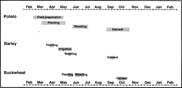
Figure 10.
Agricultural Cycle
Forest leaves and needles are used in several ways to enrich fields. Leaves can be put directly onto fields, in which case they are usually first burned and then the ash is dug into the soil. This is probably done mostly by people who have no livestock and lack the opportunities to follow the preferred approach of enriching forest-floor products with dung and urine. This composting practice is very popular among Khumbu farmers, as it has been among many people who practice mixed agropastoralism in other parts of the world. It is a common technique in Nepal among middle-altitude agropastoralists. Khumbu Sherpa place great value on the use of birch and rhododendron leaves and conifer needles for fertilizer, and have a wealth of knowledge and beliefs about this facet of farming. They consider rhododendron and birch leaves to be the best resources. Both of these, they observe, rot more rapidly than conifer needles. The best of all for fertilizer are said to be the small leaves that have already decomposed on the forest floor for several years. Such leaves collected from under rhododendron bushes are preferred since they compost especially quickly. Sometimes leaves and needles are put directly onto fields, in which case the mounds are usually burned and then the ash is mixed into the soil. The usual practice, though, is to first use them as livestock bedding and compost them. The resulting deep rich fertilizer is called mandur .
Little use is made of green manures, although some weeds and crop residues such as barley stubble may be plowed into the fields in the autumn. Winter cover crops are not planted, nor are legumes. No chemical fertilizers are used. Ash, however, is added to fields. Some families set aside ash from the family hearth in a special place for use in the spring. Some, as already mentioned, also burn vegetation gathered from nearby woodlands directly on the field.
By the middle of March potato planting is underway in Nauje and the gunsa.[63] Teams of women work the terraces, most armed with hoes and others carrying small baskets of small whole tubers and sometimes also baskets of cut pieces of potatoes.[64] Groups of women form double, facing lines, each woman working in team with a partner. The women in one line each hold a small basket with seed potatoes in it, the women in the other line each churn the soil with their hoes, simultaneously mixing fertilizer with soil, breaking up clods, and covering the potato seeds that their partners lob into their work area. As the women wielding hoes work back and forth over patches of earth their partners casually but deftly toss potatoes into the pockets momentarily opened up in the soil. From time to time partners change tasks. The line of workers sweeps across terraces, covering in a day ground that could take a week or two for an individual family. The work as a whole is easy, reckoned by some to be less arduous than spending the day laboring in a tourist lodge.
Days tend to be short, beginning late and ending early, a contrast to the more intense pace of harvest work. Breaks are frequent for tea, snacks, and conversation with one another, other groups, and bystanders.[65]
It is considered best to plant as soon as possible after the soil has been initially broken in the spring in order to provide the potatoes with optimal moisture conditions for sprouting. Seed potatoes, small whole tubers specially set aside from the last harvest, are the main planting material.[66] These are selected for their small size and average only 2.5 to three centimeters in diameter.[67] If there are insufficient seed potatoes farmers resort to cutting and planting pieces of larger tubers, which are usually planted within a few hours of being cut. Usually these tubers are simply cut in half, each half having one or more eyes. Seed potatoes and tuber pieces are planted across the entire field. No rows or beds are made. Planting is usually very dense with only ten to fifteen centimeters between seed potatoes.
It is common to plant several varieties in a field, mixing the seed pieces up before planting to create a homogenous planting pattern, then separating the types again at harvest for storage and consumption. A single family may plant as many as five or six varieties in a field. Typically, though, such fields are predominately in one or two varieties planted with seed potatoes stored from the previous autumn's harvest, whereas the rest of the planting material consists of a very small number of seed potatoes obtained from exchanges with friends and grown as experiments or for fun.[68] Other crops are usually not intercropped with the potatoes, although occasionally families interplant radish into the fields ten days to four weeks later.[69] Radish planting is not carried out by work groups, for it is a simple matter for a woman to plant a field herself, pausing every meter or two to dig in a heel or a trowel-sized weeding tool (koma ) and drop in a radish seed.
Potato planting usually proceeds from lower-altitude settlements towards the high-altitude sites. Nauje and gunsa planting take place first, followed about two weeks later by planting in the other main villages. As families finish fields in the main village they begin to move higher into the secondary agricultural sites and phu. In the Bhoti Kosi valley, for example, by the end of April planting is finished at Thami Og and Teng, and by the first days of May is underway at Chosero, Mingbo, Tarnga, and Marulung farther up the valley.[70] Planting at the still-higher-altitude sites of Goma, Arye, and Chule does not take place until late in the month. The full potato-planting period may last up to eight weeks for families with both gunsa and high-altitude fields.[71]
In a region with such a short growing season and where agriculture is carried out in so many different altitudinal and microclimatic sites, the timing of planting at particular sites becomes a critical decision. Sherpas
have accordingly refined site-specific planting calendars that integrate local knowledge of microclimates with knowledge of local crop varieties. Their intimate familiarity with the climatic conditions at specific places, the growth characteristics and fitness of different crop varieties, and the risks to plants at different stages of their growth enable them to choose planting times that minimize the chances of major damage from particular Khumbu climatic stresses. Farmers are especially concerned with avoiding the dangers of late and early frosts and untimely heavy rains. Crops planted too soon run the risk of succumbing to spring frosts. Buckwheat planted too late may be more vulnerable to midsummer rains and autumn frost and snow. Late-planted tubers do not achieve full size, and late-planted buckwheat may not develop mature grain. But other factors besides weather and the growing season are also important in decisions about the timing of planting, including household evaluation of labor availability, the scheduling of other household economic and social responsibilities, and proper astrological conditions. All decisions must be workable from each of these standpoints. Compromises are sometimes necessary, and if need be families divide forces to work in several different parts of a valley simultaneously.
Individual families make their own decisions about when to plant and they develop their own means by which to decide on the correct date for a particular site and crop. Environmental markers are often used to judge when the best planting window has arrived for a particular place and crop. Spring phenomena such as the blooming of certain flowers, bird migration, and the thaw of winter snow and ice are used in some cases. In Nauje and Khumjung the blooming of iris (themi mendok ) is taken as one indicator. Some Khumjung families note the timing of the passage of ducks en route to Tibet. Some Nauje families formerly took the spring breakup of the frozen waterfalls that drape Kwangde as a sign to plant potatoes. Most common of all is the use of sun and shadow markers. In Phurtse, for example, people keep track of the shadow of Area Dablam, a peak east of the village, on the slopes of Khumbu Yul Lha. There are three different shadow points. The first two mark the time for potato planting at the main village and the high-altitude settlements respectively, and the third, reached ten days after the second, indicates that it is time for buckwheat planting in Phurtse. Dingboche planting time is chosen by consulting the shadow of Ama Dablam as it falls on a small shrine near Orsho, between Dingboche and Pangboche. Once this event has occurred families choose a specific day to begin barley planting based on their personal horoscope.[72] At Marulung potato-planting time is read from the sunrise light coming over a particular boulder. At Phurte, in the lower Bhote Kosi valley, people note the sun's position, watching where the morning sun breaks over the ridge.
Some families observe the sunlight within their own houses; it is time to plant potatoes when a sunbeam passes through a particular window or when light filtering through a roof opening strikes a certain standing beam. At Samde people take their guidance from the location of the setting sun.
Not all families perform their own calculations to know when a planting period has arrived in an area. Some are content to follow the lead of others, and in a particular community the judgments of certain individuals may be especially respected. Planting knowledge such as the reading of environmental indicators is passed on between generations and shared openly with others. It may change through time, and indeed must change in order to adjust to the different growing season requirements of new crop varieties.
Environmental markers do not determine the exact day on which a family plants. They simply provide an alert that it is no longer too early to plant a particular crop in a certain place. The choice of the exact date is based on household labor commitments, the decision of the women's work groups as to the order of the fields they will plant, and the horoscope of the male head of the household. Luck (yang ) is considered to play a major role in agriculture, and learned men and Tibetan almanacs may be consulted to arrive at the best possible day to plant. People also may trust to their "lucky days" or avoid their "unlucky days." Every Sherpa has both lucky and unlucky days of the week, the particular days involved varying with the day of the week on which he or she was born.
Most families have to dovetail the scheduling of potato planting with the requirements of preparing and planting grain. This is relatively simple for buckwheat which, due to its susceptibility to late frosts, is not planted until late May. Barley planting requires more schedule adjustment. In order to be mature for harvest in late September the crop must be planted at the beginning of April, a time when families with land at Dingboche would otherwise be preoccupied with potato planting in their main village fields. Pangboche families cope with this conflict by interrupting preparation of the potato fields in the main village in order to prepare and plant Dingboche barley fields. Most of them also plant potatoes at Dingboche once they have the barley in, risking frost danger for the convenience of thereafter being able to focus entirely on Pangboche potato and buckwheat planting for the rest of the spring.[73] Some families divide their efforts once the barley is planted, with some family women remaining at Dingboche to plant potatoes while other female family members return to resume Pangboche operations.
Khumbu techniques of preparing and sowing grain fields require much less time and effort than does planting potatoes. Buckwheat requires especially little work since it is not manured and the task is usually
completed in a day or two. Both barley and buckwheat fields are plowed twice with a zopkio- or yak-drawn scratch plow. The first pass with the plow breaks the ground. During the second seed is broadcast.[74] According to local custom men guide the plow while women broadcast the seed. The sower walks behind the plow carrying a basket or tin can full of grain, hurling seed down at the furrows with a forceful overhand delivery intended, perhaps, to bury the seed deep in the fresh earth. As often as not, however, the seeds simply ricochet back into the air. Barley fields are then smoothed by using a zopkio or yak to drag a small log across the field or else by hauling a juniper bough across it by hand.
Barley is the only irrigated Khumbu crop.[75] Between late April and the arrival of the summer monsoon rains in mid-June it is necessary to supply barley fields with water on three or four occasions, and if the monsoon rains arrive late irrigation may be continued for several more weeks. Water is taken from the Imja Khola and led in a small, unlined ditch more than a kilometer to the head of the large, alluvial terrace on which the settlement is situated. Here the flow is directed into two channels, one running down the center of the settlement and the other along the foot of the slope on the northern side. Small intake ditches plugged with rocks, rags, and mud lead from these channels into individual fields. Here the water is led into a set of furrows that dissect each field into a number of three-meter-wide beds. It is then splashed onto the crop with a specialized long-handled wooden tool (ongbu ). There is no community management of water use. Families draw what water they need whenever they desire, even though this sometimes creates shortages of irrigation water for families whose fields are farthest from the head of the system. There is communal organization, however, of the maintenance of the main irrigation channels and their opening each spring. Each April the community celebrates kachang ("ditch beer"), a day on which all the families of Dingboche gather to worship the gods, prepare the irrigation system, and witness the transfer of office between two community officials (nawa ) charged with enforcing a set of local regulations affecting pastoralism and agricultural practices (local resource management institutions are discussed further in chapters 4 and 7).[76] On this day each household must contribute at least one laborer to the crews readying the irrigation system. Male volunteers move boulders that may have choked the outtake from the river, while women clean the ditch that leads to the village. The new nawa choose the day on which irrigation will begin.
Planting season culminates with a ritual protection of the crops. In Khumjung-Kunde, Phurtse, and Pangboche (and formerly also in Thamicho) a circumambulation of all the fields in the settlement is performed each May after planting is completed in order to ensure the safety of the crops.[77] Groups of villagers, monks, and village lamas carrying prayer
flags, sacred books, temple statues, and ritual implements circle the outer edge of the settlement fields, accompanying themselves with cymbols, horns, and drums and stopping from time to time to plant prayer flags and recite prayers to the local gods. The rite is known variously as Tengur, Chokor (from kor , referring to circling) and Orsho (from the practice of collecting grain from each household to finance the ceremony). In Thamicho, where it is called Chokur , the circumambulation was a multivillage enterprise and was carried out differently in alternate years. One year the monks from Thami monastery circumambulated the fields of the three settlements of Thami Og, Thami Teng, and Yulajung and their outlying hamlets. The next year the same route was followed by the head lama of the Kerok temple. Khumjung and Kunde also hold a joint protective ceremony (here called Orsho ) in which all the fields of both villages are circled each year, but the saying of the associated lapsong prayers rotates annually between the two. Phurtse and Pangboche villages each carry out their own circumambulation, which is known in this part of Khumbu as Tengur . In Pangboche the fields of both the upper and lower Pangboche village are circled.
The ritual is taken very seriously. Some of the most sacred things enshrined in the village temples are taken out at this time and paraded. Care is taken to collect grain from each family of the community and to extend protection to each—farmers whose fields were inadvertently omitted from the blessed boundaries would be very angry indeed. The costs of an improperly performed ritual can be high, for it is believed they can directly endanger the crops of all villagers.
Despite the careful timing of planting and the conducting of protective rituals it is not uncommon for May frosts to damage both potatoes and buckwheat. Different families respond to this situation in different ways. One common reaction is to do nothing and make the best of what crop survives. With buckwheat (but not potatoes), however, some families replant the crop. Good results, however, are not guaranteed by this effort, for the late-planted crop may be endangered by heavy, early-summer rains, and at best yields will be low given the short length of the Khumbu growing season. In 1986 about half the families of Phurtse chose to replant and half chose not to. That year those who did not replant had better harvests.[78]
Crop Care
Women, again usually working in reciprocal work groups, carry out the weeding of potato, barley, and buckwheat fields. In the main villages this is mainly a June activity, although it begins in late May in Nauje and Dingboche barley is also weeded in late May. In 1987 weeding was
underway in Nauje on May 26 and by May 29 many families were at work in the fields. Weeding was completed here on June 10. In Phurtse, by contrast, weeding was primarily a late-June activity. The precise timing depends on families' assessments of the size of the weeds and the weather as well as their other work priorities.
Usually fields are only weeded once, although potato fields may, if time allows, be weeded a second time. Families who conducted a second weeding in Nauje in 1987 did so two weeks after the first. Many families also weed again in autumn before later weeds have the opportunity to seed. These weeds can then be dug into the fields as green manure. Weeds can also be useful in other ways. Some are valued as human food (lu cherma ), although one of these must be double cooked first to make it palatable. Weeds may also be used as fodder.
Weeding is considered to be one of the more laborious field tasks. This is due in part to the Sherpa custom of employing a short-handled hoe or a weeding tool for the task, both of which require constant stooping or squatting. Weeding a potato field can occupy twice the time as planting it, and weeding buckwheat is considered far more laborious than weeding potatoes. A 1,000-square-meter field planted to potatoes can be easily weeded in a day by three people, but the same area in buckwheat is likely to require four days. The time required for weeding potatoes is slowed down, however, if women also take the opportunity at this time to mound earth (sa kongduk ) around potato plants. This is considered to benefit both plant and tuber growth, but many people forgo it if their free time is limited.
All weeding is completed by the Dumje festival, a seven-day celebration which culminates on the full-moon night of June—July. After this festival all further field work was once banned in all the Khumbu villages until harvest. The Dumje rites thus come at an important time in the agricultural cycle, the point where the crops and the well-being of the villages are thereafter entrusted to luck and the will of the gods. The protective rites of the festival are indeed the great religious event of the year in Khumbu. Dumje is the one festival considered by Khumbu Sherpas to be distinctly Sherpa and it is a powerful expression and reinforcement of village solidarity.[79] Its celebrations include a number of masked dance performances as well as daily communal feasts and nightly parties. But the heart of the festival is a set of exorcism rites that protect the village and its inhabitants from evil including, presumably, such calamities as crop failure.[80] It is held today at Thami Teng, Khumjung, Pangboche, and Nauje, and a similar celebration (known as Chojen ) is conducted by a separate group of Thamicho families at Kerok.[81] Since the timing of the festival is fixed by a lunar-based calendar, it varies from year to year by up to several weeks.[82]
After weeding is completed another set of Khumbu community measures aimed at safeguarding crops also goes into effect in some parts of Khumbu. These are the regulations aimed at protecting crops from blight. It is believed that these must be activated each summer by late June or early July (early Dawa Tupka), and some communities put them into effect immediately after Dumje. They are considered important enough that enforcing the regulations was the primary responsibility of community nawa, some of whom also were in charge of enforcing seasonal pasture exclusions. While today the full range of these regulations is only maintained in Phurtse, Pangboche, and Dingboche, they were also implemented in living memory in Khumjung, Kunde, Nauje, and Thamicho. These Khumbu measures were apparently unique among Sherpas. They represent an example of close, community cooperation and the overruling of individual family freedom in economic decision making on behalf of the welfare of the community itself.
There were several different types of blight-protection measures. One set of regulations attempted to restrict contact with crops to prevent the outbreak of the fungus and slow its diffusion. To accomplish this communities banned people from entering fields until harvest and excluded livestock from the settlement area until after harvest in order to keep them out of the fields. Keeping people away from crops also helped keep fields free of bad smells that were believed to offend plants and lead to blight. Stories are told of how blight has been brought on by people passing near or through fields, who smelled strongly of soap, garlic, or milk. Many people note that this accounts for field edges near trails often becoming infected with blight, and villagers can tell tales of specific incidents such as the Pangboche case where a line of blight-killed plants traced the path taken by a villager who had crossed a field after bathing.
There were also rules concerned with preventing the outbreak of blight through halting sympathetic responses by crops to events involving the death or drying of plant material in the village area. Among these were prohibitions on cloth dyeing (for which vegetable dyes were common), drying edible, wild plants, and bringing freshly made bamboo mats and freshly cut fuel wood into the village. In some places these rules were still more stringent. In Phurtse and Pangboche no fuel wood, fresh or dried, could be brought into the village once the danger season for blight had arrived in July—August (during the sixth month, Dawa Tukpa) for fear that green wood might be mixed inadvertently with dead wood in fuel-wood loads.[83] In several settlements concern over the importation of freshly cut wood apparently underlay customary summer bans on roof repair (and in some areas on house building). Phurtse today continues to ban outdoor fires, including burning juniper in reli-
gious rites, after the fourth day of the sixth lunar month (a date known as Dawa Tukpa Seshi ). The ban remains in place until the beginning of the potato harvest. At Dingboche this is taken another step further, and on the same day of the sixth month all fires are banned in the settlement until harvest time, including hearth cookfires. Habitation is thus impossible for more than two months. This custom is still deemed to be important to enforce. Many people with Dingboche fields were unhappy and some were outraged when the nawa failed to prevent a 1987 U.S. Everest expedition from camping in the community and allowing their porters to light cookfires at a time when this should have been forbidden.
The rationale underlying these preventive measures seems to be twofold. Some bans are clearly related to fear of contagion and keeping humans and livestock from accelerating its spread. Others are concerned with keeping manifestations of death and decay away from fields. These bans seem to reflect a concern about offending the spirit of plants by polluting fields with the presence of plant death and bad smells. They parallel Sherpa beliefs that crop plants can take offense to the introduction of new varieties or offensive species; for Sherpas plants are sensitive and show their unhappiness by withering and losing their productivity.[84]
Harvest
Harvest season in Khumbu is the busiest time of the year, the only season when work is carried out throughout the daylight hours regardless of the weather. Women move to and from the different settlements in which the family owns crop and hay fields while men add hay (and sometimes also barley and buckwheat harvesting and threshing) to their herding and tourism work. This requires a complex scheduling of family labor across a two-month-long period and often across a variety of different locations. Khumbu families move up and down the valleys from mid-August potato harvesting in the gunsa settlements to September harvesting in the high-herding settlements and the final harvest in late October and early November of a few last fields in the main village. Formerly a number of villages as well as Dingboche enforced community restrictions on the day harvest could begin. Families who began earlier were subject to fines. This practice is still followed in Phurtse and Dingboche. Otherwise the decision is entirely up to individual preference. Household decisions about when to harvest particular agricultural sites during this time are linked to evaluations of the maturity of both potato and grain crops, communal restrictions on resuming field work, increasing risk of crop damage from bad weather, the need to harvest crops ahead of livestock herds descending from the high summer pastures, household labor resources, and astrological concerns.
The first potatoes are harvested as early as the first of August in the gunsa settlements and in Nauje, as families eager for new potatoes dig a few loads for their immediate needs.[85] Harvest is underway in earnest in the gunsa by mid-August, by the end of the month in Nauje, and a few weeks later in the other villages. Most families have completed harvesting most of their main village fields two weeks to a month later.[86] It is not uncommon, however, for families to leave some of the main village potato harvest to complete later, after the barley, buckwheat, and higher-altitude-settlement potatoes are safely in. By early October many families are at work in the higher-altitude potato fields of the valleys and by the middle of the month this is usually completed. For most families that marks the end of potato harvest. The few families who never found time to complete the digging of all their main village potato fields, however, work on. They finish up the harvest only at the end of October or during the early days of November, sometimes working in the snow.
Fields are mostly harvested by reciprocal labor groups of eight to fifteen women. Harvesters move in a line across a field, digging up tubers with their hoes and then deftly flicking or tossing them into lines of baskets set up ahead of the advancing team. Different varieties and sizes of potatoes are tossed into different baskets so that they can be stored separately. Tubers of the small size preferred for seed potatoes are carefully set aside. So too are potatoes that are infected with wart or scab virus; these are eaten immediately before they rot. Men carry the filled baskets in from the fields to the house or hut where the potatoes are air-dried for a week or so before they are stored.
Several different storage techniques are employed. Small quantities of potatoes are cut and sun-dried (riki shakpa ), and small amounts of potato flour may also be set aside. At low altitudes, including in Nauje, it is possible to store potatoes indoors through the winter. The usual technique is to store tubers indoors in the lower floor of the house either in open, wooden bins (riki dom ) or inside large, cylindrical containers made from bamboo mats. Care must be taken in cold weather to prevent potatoes from freezing and during bad winters hay may be packed around the wooden bins as insulation. It is too cold in the other main villages and the higher-altitude settlements for this type of storage and in most of Khumbu potatoes are put into underground storage pits (miktung ). Storage pits are approximately 1 to 1.25 meters deep and are lined with straw or juniper boughs and made waterproof with a top layer of straw capped by a firmly packed-down layer of mud. If moisture is kept out underground storage can preserve potatoes for ten or eleven months.[87]
The season for harvesting grain overlaps with potato harvest, and when barley and buckwheat reach the correct degree of maturity their
harvest becomes of the utmost urgency. Buckwheat is very susceptible to major damage by late autumn snow or heavy rain, and there is also considerable danger that livestock, wildlife, or birds may destroy the crop. When snowfalls occur while the buckwheat crop is still in the fields some villagers attempt an emergency harvest. Rather than first cut the stalks, carry them to a threshing place, and thresh the grain from the stalks, they instead speed up the process and simply beat down the buckwheat stalks with poles right in the field. If the snowfall proves to be less heavy than feared this tactic can misfire and result in less grain being harvested than would have been otherwise. This was the experience of some Phurtse families two decades ago. In nearby Pangboche, however, heavier snows devastated the harvest of those families who did not rush to harvest what they could as quickly as possible.
When early snows do not rush the process buckwheat harvest begins in late September and lasts for several weeks.[88] Barley harvest also takes place in mid to late September. The two grains are not equally mature at this time. Buckwheat is only harvested when fully ripe. Khumbu Sherpas prefer to harvest barley, however, a week or more before it fully matures. The origins of this custom are not clear. It may be that farmers are reluctant to risk the crop longer to the danger of heavy rains or early snows or that they do not want to delay any longer opening the Dingboche area to grazing. In either case farmers may feel that by harvesting slightly before maturity there is less risk of grain being lost during the process.
Both men and women work together at harvesting grain, although here again most of the labor is contributed by women. Reciprocal work groups are common, but some families prefer to harvest grain as a smaller, family operation. The two grains are harvested using different techniques. Buckwheat is cut with the same type of sickle that is used to cut hay. Workers grasp the stalks with one hand and with the other wield the sickle and cut the stalks close to ground level. Barley, by contrast, can be harvested in several ways. Whereas some people cut the grain from the stalk in the same manner as buckwheat, most simply pull the entire plant out by the roots. This is an easy operation. At Dingboche a group of harvesters can very quickly harvest a large field, a crew of four uprooting barley while two other workers bundle it into stacks. Men and women work their way in a line across a field, uprooting barley stalks and placing handfuls of them behind them for a second crew of women who shake the dirt off, line up the grain heads, and tie together clumps of barley with straw. These are then stacked in small pyramids in the field and later consolidated in large, outdoor stacks.
Buckwheat threshing takes place immediately after harvest. Here again several techniques are employed. Some people prefer to beat or
rub the grain free on rocks. Others beat the stalks with a short, forked stick. Often a bamboo mat enclosure is set up to keep out wind and to capture flying grain. Buckwheat stalks are valued as fodder and after threshing they are piled, dried, and stored. Barley, by contrast, is not threshed until a month or more after it has been harvested and is beaten with a jointed flail (geli ). In late October and early November groups of women carry out the threshing with poles on large community threshing grounds in Dingboche.
The agricultural year draws to a close in mid to late November. The few families who have neglected to complete the digging of their potato fields due to more pressing business now dig in the frozen soil for the final tubers, sometimes working while the snow falls. Some families also redig their potato fields now or plow the fields that had been in grain to loosen the soil in the belief that this will improve the coming year's crop. Some families in Phurtse note that this process also makes the spring's work easier, for by deep digging the soil of next year's potato fields in the late autumn, when there are no other agricultural tasks, they save themselves effort during the busier days of spring. In the spring it is then sufficient to simply dig the fields once rather than the usual double digging. Planting can be done simultaneously with loosening the spring soil and digging in manure.
Labor Commitments
The amount of labor required to produce Khumbu crops varies considerably among crops. Potatoes require by far the greatest labor, demanding a double hand-digging of fields for preparation and planting and a third digging at harvest as well as one or more weedings. Buckwheat is much less trouble in terms of field preparation and planting, for it is not manured and a few hours of plowing and broadcasting serves to plant the crop. Weeding the buckwheat, however, is extremely time consuming as is harvesting it with sickles. Barley requires more work than buckwheat, for it must be manured and provided with irrigation. It is, however, much less trouble to harvest.
The amount of time devoted to producing a crop also varies among different fields. Considerably more effort is usually put into the care of fields nearby the house than those located elsewhere in a settlement, much less those a half an hour, a half a day, or several days away. Fields adjacent to houses are usually the best-manured and the most carefully weeded. Special attention may also be given to fields in the high-altitude, secondary agricultural sites. The crops in the high-herding settlements, by contrast, are sometimes given less care. Here weeding especially may be relatively neglected. The amount of time devoted to
potato production in both main and secondary fields also varies considerably among households. Many families only conduct a single weeding whereas others perform this task twice. Some require more time and work to prepare fields because of their greater supplies of manure. A few families in Nauje and Khumjung have their potato fields plowed rather than digging them with hoes, thereby saving a great deal of labor. And the amount of work a particular family must invest in a given field also varies from year to year. Here the size of the harvest makes a considerable difference. A bumper crop may require much more effort to harvest and store. But a poor potato crop can be highly time consuming to harvest in terms of the commitment of time relative to the returns in stored food. In a good field in a good year a single worker can readily harvest three or four forty-kilogram loads of potatoes in a single day. On poorly producing land a day's labor may yield only a single load. One Nauje family farming relatively marginal land outside of the main village found in 1987, for example, that twenty-five person-days of labor were required to harvest 26.5 loads of potatoes from seven small terraces.
The relative labor requirements of different agricultural tasks and the degree of variation in the labor invested in them can be seen in a comparison of the farming practices of two Nauje families in 1987. Family A farmed seven small terraces in the vicinity of the village (Mishilung and Nyeshe). Figures are given for the five fields at Mishilung only. Family B
Table 9 . Nauje Potato-Cultivation Labor Inputs | |||
Task | Person-days of Labor | % of Total Labor | |
Family A | |||
Field Preparation | 13 | 35 | |
Planting | 4 | 11 | |
Weeding | 8 | 22 | |
Harvest | 12 | 32 | |
Total | 37 | 100 | |
Family B | |||
Field Preparation | 6[*] (22) | 9 (26) | |
Planting | 16 | 23 (19) | |
Weeding | 12 | 17 (14) | |
Harvest | 35 | 51 (41) | |
Total | 69 (85) | 100 | |
* These fields were plowed rather than being hand dug. Digging them would have required another sixteen person-days of labor. Figures in parentheses refer to estimated adjustments for hand-dug fields. | |||
farmed eleven small fields in Nauje itself. Family A was part of a reciprocal labor group whereas family B relied mainly on wage labor. Family B also plowed some of its larger fields which accounts for the discrepancy in terms of labor used. For family B I have shown a second set of figures which is adjusted to show labor investments if the fields had not been plowed.
Nauje family A harvested only eighteen loads of potatoes in 1987 from its five fields at Mishilung with an investment of thirty-seven days of labor. Terraces of Nauje family B , by contrast, yielded 64.5 loads in 1987 (down considerably from nearly ninety in 1986 as a result of blight, but still far more than the family itself required) with an investment of sixty-nine days of labor. There are thus considerable differences in labor efficiency relative to yields as well as to the relative amounts of time the two families devoted to different agricultural tasks. Nauje family A devoted considerably more time than family B in preparing its fields and weeding them, but harvested only eighteen loads of potatoes with thirty-seven person-days of labor investment (2.1 person-days of labor per load). Nauje family B harvested nearly twice as many potatoes per day of work invested, harvesting 64.5 loads with sixty-nine days of labor (1.1 person-days of labor per load). At this rate of return on labor input, a family could attain self-sufficiency in potatoes with less than a month of labor devoted to the effort. Less than half that much labor would need to be spent on grain crops.
4
Good Country for Yak
Pastoralism in Khumbu must cope with the challenges of severe winter temperatures and meagre winter and spring range resources. Stock-keeping at these altitudes can be a highly risky endeavor and in bad years some stockkeepers can loose much of their herd to starvation, cold, and disease. Their choice of which types of livestock to herd, the means by which they can best exploit different altitudinal and seasonal range resources, and the ways to best minimize stock loss in the difficult winter-spring period represent adaptive responses to the high-altitude conditions of Khumbu. Yak can thrive at these altitudes, and Khumbu is good country for yak, but even yak require special attention if they are to survive all year in Khumbu conditions. Sherpas have had to develop an ingenious set of pastoral practices and seasonal herding patterns and make a major commitment to cultivating hay in order to safely support their yak herds all year on Khumbu resources.
Environmental adaptation thus certainly underlies and to some degree broadly shapes characteristic Khumbu patterns of herd composition and herding movements. Khumbu pastoralism, however, is a complex activity that also reflects a number of other cultural, social and economic factors. Cultural values and lifestyle preferences influence decisions about herd composition and size, the degree of multifamily cooperation in herding, and the role of community regulation of livestock management. Differences in household wealth, subsistence orientation, and involvement in commercial production create different herding strategies, scales, and goals. And cultural knowledge, assumptions, and beliefs about livestock, predators, pastures, climate, disease, luck, and
spirits also influence herding decisions through the role that they play in herders' interpretations of environment, resources, and risks.
This chapter surveys contemporary Khumbu pastoralism. It begins with an introduction to the types of stock herded, household and village patterns of herd composition and size, herding strategies and goals, and regional range resources. The second half of the chapter then focuses on the diverse factors that influence family and village seasonal herding patterns. It explores the ways in which these annual pastoral cycles of transhumance, like the agricultural cycle, are complex cultural achievements in which Sherpas have successfully integrated knowledge of local environments and the characteristics of different types of livestock in a set of pastoral strategies. These strategies, in turn, will be seen to reflect sociocultural values, communal resource-management efforts, and individual households' conditions of wealth, labor availability, and lifestyle preferences.
Yak, Nak, Crossbreeds, and Cattle
Khumbu Sherpa pastoralism is primarily based on the herding of a set of different varieties of cattle (chungma ), as shown in table 10. For many generations it has been especially characterized by the keeping of yak, particularly the female nak. In recent years households in some villages (especially in Nauje, Khumjung, Kunde, and Thamicho) have begun keeping increasing numbers of yak-cattle crossbreeds and cows. Since 1957 the number of nak has declined by nearly half (from 2,061 in 1957 to 1,121 in 1984), and today yak and nak constitute 58 percent of Khumbu cattle rather than the 79 percent share they comprised. in 1957. Yet they remain the most numerous and the most valued large livestock in the region. Yak and nak have long been an important symbol of wealth and the keeping of a large herd confers considerable status on its owner. They are prized not only for their economic and social utility but also out of appreciation for their beauty.[1]
Yak herding is a central facet of subsistence in much of highland Asia. The great, shaggy, black, brown, multihued, and occasionally white bovines are one of the most distinctive and widespread residents of the high, alpine lands of the Great Himalaya and the vast expanses of the Qinghai-Tibetan plateau. Yak herding is important virtually wherever there are Tibetans or their close cultural cousins, from the higher reaches of the Himalaya across Tibet to the high country of Gansu, Sichuan, and Yunnan, and even beyond in an arc encompassing Mongolia, the Mongol-inhabited Lake Baikal country of Siberia, some Kirghiz (Kyrgyz)-inhabited areas of Xinjiang and Kyrgyzstan in Central Asia, and portions of the Pakistan-administered Karakorum range. Most of
Table 10 . Khumbu Cattle Numbers and Emphases, 1984[*] | |||||||
Kunde | Pangboche | Khumjung | Phurtse | Thamicho | Nauje | Khumbu | |
Yak | 62(19%) | 69(22%) | 62(17%) | 67(17%) | 109(12%) | 44(15%) | 413(16%) |
Nak | 85(26%) | 132(42%) | 88(24%) | 261(68%) | 525(56%) | 30(10%) | 1,121(43%) |
Zopkio | 56(17%) | 21( 7%) | 82(22%) | 7( 2%) | 178(19%) | 138(48%) | 482(18%) |
Zhum | 80(24%) | 32(10%) | 60(16%) | 27( 7%) | 41( 4%) | 18( 6%) | 258(10%) |
Pamu | 42(13%) | 57(18%) | 74(20%) | 16( 4%) | 57( 6%) | 53(19%) | 299(11%) |
Lang | 5( 2%) | 7( 2%) | 7( 2%) | 5( 1%) | 35( 4%) | 3( 1%) | 62( 2%) |
Total | 330 | 318 | 373 | 383 | 945 | 286 | 2,635 |
* Numbers of stock and percentage of cattle by type. | |||||||
SOURCE : Data derived from Brower 1987:189 | |||||||
the world's yak graze the high country of the Qinghai-Tibetan plateau. In Qinghai Province alone there are 4,920,000 yak, by one estimate a full third of the world yak population (Zhang et al. 1987:88), and in the Tibetan Autonomous Region there are more than an additional four million head of stock (Yan 1986:241). Another 700,000 are herded in one Tibetan-inhabited county in southwest Gansu, Gannan Tibetan Autonomous Prefecture (Li 1986:133). The Himalaya supports far fewer head. The entire range may be the home of fewer than 100,000 yak, and estimates of the number of yak in Nepal range from fewer than 9,000 to somewhat more than twice that (Brower 1987:202 n. 1).[2]
Yak are not likely to be confused with anything else in Asia.[3] Large-bodied, long-haired, long-horned and humped, yak are one of the world's most physically distinctive cattle types. Domestic male Nepalese yak attain a size of 230 to 360 kilograms and females from 180 to 320 kilograms (Brower 1987:166), rather smaller than the 1,000 kilograms that wild yak are said to sometimes reach but still a large animal in comparison to other varieties of Himalayan and Tibetan cattle. They are also notable for the deep, grunting, staccato bellow that gave them their Latin appellation Bos grunniens ("grunting cattle") as well as for their heavy coats. This coat ends in a distinctive fringe of long hair on the legs and flank and is complemented by an extraordinarily bushy tail—so striking that yak tails were accepted as tribute gifts by the Chinese imperial court and were in demand as a trade good in India for use in Hindu temples.[4]
Yak are superbly suited to year-round life at high altitudes. They can endure altitudes and harsh weather in which cattle or crossbreeds could not survive and are even able to thrive in the cold of a Khumbu winter. They do not require stabling even at 5,000 meters in January. In midwinter yak are able to forage in snowy country by seeking out patches of ground that the wind has swept free of snow or by pawing through the snow to feed off quiescent grass. Sherpas believe that yak are so much creatures of the heights that they will sicken and die if taken to altitudes of less than 3,000 meters during the warm-weather months. Below 3,000 meters they are thought to succumb rapidly to "low-altitude sickness," a malady Sherpas associate with both altitude and unhealthy water sources. Research on yak physiology has found that they are physically adapted to cope with high-altitude conditions. Besides their heavy coats they have larger lungs and thoracic cavities than other cattle, and their unusual blood composition may also enable them to adapt more effectively to high-altitude conditions (Brower 1987).
Yak and nak provide a number of valuable products and services.[5] Both males and females provide meat that Sherpas prize above all other. Like other Tibetan people Sherpas do not subscribe to Hindu beliefs
about the sanctity of cattle and have no qualms about eating beef.[6] Before the 1960s old animals were culled each autumn and winter, slaughtered, and butchered by itinerant specialists of the lowest social status who came for this purpose from Tibet. After socioeconomic change in Tibet during the 1960s these butchers ceased coming to Khumbu and culling was virtually abandoned.[7] One Tibetan butcher, however, is now living in Khumbu and occasionally practices his craft. Some Sherpas suggest that the problem with culling cattle today is not so much the absence of butchers as it is the need to avoid offending government officials who reside in Nauje.
More important to subsistence than yak meat is nak milk. Of its many uses, the most important is the production of butter (mar ). Some milk is also processed into cheeses, including both a soft cheese (shomar ) that is consumed fresh and spread on potato pancakes and a dried, hard cheese (churpi ) that is a valued trail food. Butter is perhaps most often consumed in tea, for it is an essential ingredient of the basic beverage of the region, the solcha or salt tea familiar across the Tibetan culture region. The making of butter is also an important strategy for storing milk, for little fresh milk is available in the region other than in summer. Butter is much preferred over cheese in this respect and it can be kept nearly year round in Khumbu's cool climate, sometimes wrapped in skins for insulation. Yak and nak manure is also regarded as an important resource, both for fertilizer and fuel, and for many families fertilizer is the most crucial contribution of yak to the domestic economy. Both male and female yak provide hair that is shorn, spun with drop-spindles by men and women, and woven into chara , a heavy material that has many uses. Hides can be used as boot soles. And both males and females are used as pack animals and some have been trained as draft animals.[8]
Yak and nak also can provide income. Surplus meat, dairy products, and manure are bartered and sold locally. Butter is an acceptable currency with which to hire agricultural day laborers and formerly, according to oral traditions, was used to pay taxes to Tibet. Yak-hair chara are sold in Khumbu and in other nearby Sherpa regions. Considerable income can be earned from hiring out pack stock or from training stock to pull a plow. Trained teams are rare and many farmers pay a good deal of money to hire plow-teams and their drivers. And the breeding and sale of nak-cattle crossbreed calves has historically been so lucrative that it was probably the most important factor in the regional prominence of nak.
Khumbu Sherpas keep a small number of common cattle of a Tibetan variety known locally as kirkhong (Bos taurus ). These today number fewer than five hundred (Brower 1987:169,171). Despite their relatively thick coats Tibetan cattle are not hardy in Khumbu winters and must be
stabled in the lower stories of village houses and fed considerably more winter fodder than yak or nak require. Most of the stock kept in Khumbu are cows (kirkhong pamu ) that are valued for their milk and manure. During the past twenty years, as the standard of living has increased with tourism development, it has become increasingly popular for families to keep a cow or two to provide milk for their household. The small number of bulls (kirkhong lang ) play a vital role in Khumbu pastoralism, for they are bred to nak to produce the crossbreeds for sale to Tibet and to Shorung Sherpas.
The crossbreeds that are bred in Khumbu from nak mothers and Tibetan bulls display a combination of traits reflecting their parentage. In general they differ from yak in size, coat, and their lesser fitness in extreme high-altitude conditions (particularly in winter). The males, known as dimzo (or dim zopkio ), are highly valued as draft and pack animals whereas the females, known as dim zhum (or dzum ), are considered excellent milch stock.[9] Fürer-Haimendorf reported that zhum yield more milk per lactation than nak, although it is not as rich. According to his information Khumbu crossbreeds produce about ten kilograms of butter per year per head compared to the nak's seven kilograms per year per head.[10] Crossbreeds herded in Shorung were said to yield twice as much butter as those pastured in Khumbu (Fürer-Haimendorf 1975:50). It should be noted, however, that higher milk yields for Khumbu zhum compared to Khumbu nak may reflect differences in fodder feeding and the relatively greater parts of the year that the zhum are herded in the lower-altitude areas of Khumbu. Zhum could not survive, much less yield large amounts of milk, in the conditions in which nak live.
Tibetans have long practiced yak-cow crossbreeding. Tibetans along the eastern fringe of the Tibetan culture region, for example, gave such crossbreeds in tribute to the Tang emperors of China (Schaffer 1963:74). In some parts of Tibet, however, crossbreeding is not conducted due to a belief that the forced cross-species mating is offensive to local gods such as yul lha and lu.[11] The Tingri region just to the north of Khumbu is one of the areas where crossbreeds are valued and used, but are not bred. This has provided Khumbu herders with a major market for crossbreed dimzo calves and a complex trade developed in them still continues today on a limited scale. Dim zhum, considered finer milk producers than nak, although less hardy, have long been sought after by Shorung Sherpas and in the past twenty years have begun to be kept by Khumbu Sherpas in large numbers to provide family milk supplies.
In recent years a third form of crossbreed has been important in Khumbu. This is the urang zopkio , the male offspring of lower-altitude pamu or palang pamu (Bos indicus ) cows and yak. Urang zopkio are not bred in Khumbu, but are purchased at considerable expense from lower-
Female Parent | |||||
nak(f) | pamu(f) | zhum(f) | |||
kirkhong | palang[*] | ||||
(m)yak | (m)dimzo[**] | (m)urang zopkio | (m)koko yak | ||
yak(m) | (f)nak | (f)dim zhum | (m)urang zhum | (f)koko nak | |
Male Parent | |||||
lang(m) | (m)dimzo | (m)lang | (m)lang | (m)zhumi tolu | |
(f)dim zhum | ( f)pamu | ( f)pamu | (f)tolmu[***] | ||
* only found in Pharak and other low-altitude areas | |||||
** also known as dim zopkio | |||||
*** also known in Pharak as pakhim | |||||
Figure 11. Major Khumbu Cattle Breeds | |||||
altitude areas including Shorung, Kulung, and Pharak. They have become important in Khumbu as plow animals and especially as a source of pack-stock income from tourism.[12] Their value in trekking work reflects the importance of the airstrip at Lukla as a tourist entrance to the area. Sherpas do not like to take yak down into the low-altitude reaches of the Dudh Kosi gorge in order to reach the Pharak airstrip. But they have no hesitation in taking the low-altitude-fit urang zopkio to Lukla, and the crossbreeds are also capable of making the haul through Khumbu to the foot of Mount Everest. The increase in the number of zopkio since the mid-1970s has been the most spectacular recent change in Khumbu pastoralism. By 1984 18 percent of all Khumbu cattle were zopkio and the great majority of these were urang.[13] They now far outnumber yak.
Sheep and Goats
Sheep and goats have also long been a component of regional livestock keeping. Both are valued for their hair and wool, their meat, and their manure.[14] According to oral traditions sheep were an element of early Sherpa pastoralism in Khumbu, and goats may also have been raised here for centuries. But for at least the past hundred years both have been raised on a far smaller scale than nak and during the past forty years regional numbers have not far exceeded 1,500.[15] Today there are perhaps 500 in all (Brower 1987:171) and a flock of 30 head is considered large. Only a Tibetan variety of sheep is kept. The wool and meat of the Tibetan sheep are far preferred to those of the less hardy Himalayan varieties that Gurungs once herded each summer in Khumbu. These sheep must be fed fodder in the winter, but they do not need to be stabled at the altitudes of the main villages. The Khumbu lack of emphasis on sheep keeping contrasts strikingly with high-altitude pastoralism in
northwestern Nepal (Goldstein 1974, 1981; Goldstein and Messer-schmidt 1980; Rauber 1982), Tibet (Ekvall 1968; Goldstein and Beall 1990), and Mongolia, where sheep are the most numerically important form of livestock.[16] Sheep also outnumber yak in Nepalese high-altitude pasture areas to the immediate south and east of Khumbu. Most families who keep yak or other cattle do not also herd sheep, and sheepherding is primarily a pursuit of relatively poor households that cannot afford other stock. The lack of interest in the region in sheep keeping seems to reflect a cultural attitude rather than either a perception that the region is poor sheep country, as Fürer-Haimendorf (1979:13) and Brower (1987:171) have suggested, or a lack of interest in sheep products. Wool, dried sheep meat, and dried fat are imported from Tibet and bring high prices.
As far back as Sherpas can remember goatherding has been conducted on an even smaller scale than raising sheep. In 1983, when goat keeping was banned in the area as a conservation measure, there were fewer than 300 head, most of which were kept by non-Sherpa, blacksmith families.[17]
Household Pastoral Emphases and Herd Structure
There are currently several patterns of livestock ownership in Khumbu that differ not only in scale but also in the type of livestock herded, the degree to which pastoralism is a subsistence or a commercial activity, the altitudinal span of Khumbu rangelands used, the seasonal migrations followed, and the amount of wealth and labor required. There are four main patterns of herding (fig. 12). These emphasize the keeping of nak, cows or crossbreed zhum, yak or zopkio, and sheep. There are also several major patterns of keeping mixed stock herds.
Nak herders primarily keep herds of a size large enough not only to meet household requirements for milk and other products but also to produce enough crossbreed calves to make the enterprise worth the effort. Herds generally are almost entirely composed of nak, with one or two Tibetan bulls kept for breeding with them. Usually more than ten head of nak are kept, for smaller herds yield a very small return of calves. Earlier in the twentieth century there were herds of as many as eighty head, which were tended by hired herders, but today herds of more than thirty head are rare. These animals are kept much of the year in the high reaches of the valleys, often only spending a few weeks or months in the autumn and early winter below 4,000 meters. Usually the stock require large amounts of fodder as supplementary feed in winter and especially in early spring before the new grass greens. Nak herders as a result usually grow hay as well as collecting and drying wild grass for
Livestock | Herd Size | Economic Goals | Requirements | |
Yak | 2-6 | Income from pack stock | High-altitude herding huts Hayfields | |
Nak | 15-35 | Income from sale of crossbreeds Manure, dairy products | High-altitude herding huts Hayfields | |
Zopkio | 2-8 | Income from pack stock | Winter stabling | |
Cows/Zhum | 1-6 | Household dairy supplies Manure | Midaltitude herding huts Winter stabling in village | |
Sheep | 10-40 | Wool, food, manure | None | |
Figure 12 . Khumbu Pastoral Strategies, 1990 | ||||
hay. The need to invest in stock, hayfields, and high-altitude herding huts to act as winter and summer bases and barns limits involvement in this kind of herding to relatively well-to-do families. It also requires a major lifestyle commitment on the part of herders, who must be away from the main village for eight months or more of the year. Usually this task is taken on by one member of a family, who is known as the family nakpa ("nak person"). In summer these herders are often joined by the entire family and these months in the high pastures are considered by many people to be the best time of the year. But few envy the nak herders the many winter months they must spend at high altitudes in the bitter cold in the remote corners of the region. Some families who once were large-scale nak owners have had to break up their herds as the nak herders aged and were unable to interest sons in carrying on the work. In a few cases daughters have taken over the task. Today this job is rarely entrusted to hired herders, and Sherpas especially feel that low-landers are not capable of caring for nak properly. Nak herding is felt to require considerable skill, for to produce a high number of crossbreed calves a herder must know his animals well.
Households that keep cows and female crossbreeds keep them in small numbers as a source of dairy products for household consumption, and this style of pastoralism requires relatively little wealth and relatively minor lifestyle commitments. Usually only two or three head of such stock are owned and the largest herds in memory numbered fewer than twenty animals. Larger herds are kept by Sherpas in Shorung and some other areas, but there the production of milk, butter, and cheese is a commercial enterprise. In Khumbu virtually no dairy products are sold and the region has long imported butter from Shorung and Kulung. Keeping cows and female crossbreeds does not require ownership of hayfields, long periods of residence in the high pasture, or winter migration to the high herding huts. During most of the year it is simply
necessary to send cows out to the village's adjacent slopes in the morning and to round them up again in the evening. During summer the stock must be taken outside of those villages (Khumjung, Kunde, Pangboche, and Phurtse) where the settlement area is closed to grazing to protect the growing crops from livestock. But it is not necessary to make long migrations or to maintain hay fields or huts in high-altitude settlements. Typically cows are taken to areas just outside the restricted zone and herded there the entire summer from a single hut or temporary shelter located just an hour or two away from the main village. Khumjung and Kunde villagers who keep cows may move their cows as little as five kilometers to a summer base near Mong. Many owners of cows and female crossbreeds do not grow their own hay, but instead rely on harvesting wild grass, storing crop residues, and purchasing additional hay if necessary. The need to stable cows in winter and to feed them considerable fodder in the winter and spring does, however, demand considerable labor and expense.
Earlier in the twentieth century a few families kept small herds of yak to use as pack animals. These yak herds usually consisted of fewer than ten animals and the largest was probably that of a famous Nauje trader who kept as many as thirty yak to use in his caravans. Today families that emphasize herding yak and their use as pack stock in the tourist trade commonly own only two to four head of stock. Yak herding is in some ways much simpler than herding nak, for in summer they do not need to be corralled at night or milked daily and can instead be allowed to wander in the highest reaches of Khumbu. Herders simply seek them out every week or ten days to feed them salt and check on their condition. If relatively small numbers of stock are owned these can be wintered in lower Khumbu without the necessity of maintaining extensive hayfields and high-altitude herding huts.
Far more common today than yak herding, however, is owning a small number of urang zopkio to use as pack stock on mountaineering and trekking journeys. Here again the herd size is small, typically with two head of stock per household. Zopkio can also be kept without any need to own a high-altitude herding hut since they can be allowed to range freely for the entire summer with occasional day-trips up from the village to feed them salt. In the autumn, whenever they are not needed as pack animals, zopkio can be left to graze freely in the lower forests until the snowy season begins. Zopkio must be stabled and fed fodder through the winter, however, and this requires either an investment of time in collecting wild fodder or maintaining hayfields or the expenditure of a proportion of the income made from the pack stock on purchasing fodder. Fodder must also be supplied to stock when they are on upper-valley trekking trips during the late autumn, winter, and spring.
Sheep (and formerly also goats) are raised in small numbers, primarily by poor families who are unable to afford cattle but who want manure for their fields, meat, wool, and the possibility of a small income. Manure is often reckoned to be the most important benefit. Sheep and goat keeping requires less capital and lifestyle investment than any other form of Khumbu pastoralism, although in villages where summer exclusion of livestock is practiced it is still necessary to practice transhumance and herders must either spend several months living in temporary shelters and caves or maintain herding huts.
There are also several patterns of keeping mixed herds. These include household herds that emphasize nak but also include yak or zopkio, herds in which both nak and zhum and/or cows are kept, and herds that have a combination of zopkio or yak with zhum or cows. Families who keep nak may also keep a small number of zhum or cows that provide milk to the household during seasons when the nak may be herded in distant parts of Khumbu. Nak-herding families may also keep a few yak, that are useful for breeding nak to keep up herd numbers and as pack stock for income from tourism. A few urang zopkio may also be kept as income-generating pack stock. And families who keep a few zopkio or yak may also keep one or two zhum or cows to provide milk.
Herding Strategies: Village Contrasts
Besides contrasts among households in herding practices there are also some broad contrasts among villages. Nak herding predominates over the other two patterns of cattle herding in Phurtse, Pangboche, and the Thamicho villages. In Kunde, Khumjung, and Nauje, however, keeping cows and zhum as well as yak and urang zopkio herding are both more important than nak herding (table 11).[18] Phurtse families especially emphasize nak over all other types of cattle keeping whereas Nauje families emphasize it the least. In Kunde and Khumjung keeping cows and zhum is virtually balanced by herding yak, urang, and dimzo, and in these two villages very few families today herd nak.[19] Nauje families display by far the greatest emphasis on the herding of male pack stock, and especially on the herding of urang zopkio.[20]
These different village herd-ownership patterns are also reflected in different patterns of seasonal use of Khumbu rangelands. Nak and yak are kept for much longer periods of time at high altitudes than other cattle. The Thamicho villages, Pangboche, and Phurtse all accordingly keep 64 percent or more of all village large livestock in the high country for most of the year. In the case of Phurtse this reaches 85 percent. The other villages, by contrast, have more than 50 percent of their large livestock in crossbreeds or common cattle, all of which spend all but the
Table 11 . Village Cattle-Herding Styles by Percentage of Cattle, 1984 | ||||
Nak/Lang | Zhum/Pamu | Yak/Zopkio | ||
Kunde | 28 | 37 | 36 | |
Pangboche | 44 | 28 | 29 | |
Khumjung | 26 | 36 | 39 | |
Phurtse | 69 | 11 | 19 | |
Thamicho | 60 | 10 | 31 | |
Nauje | 11 | 25 | 63 | |
Khumbu | 45 | 21 | 34 | |
SOURCE : Data derived from Brower 1987:189. | ||||
summer months in the immediate vicinity of the main villages. This tendency is most pronounced in Nauje where male and female cross-breeds and cows have mostly grazed close to the village year round since the practice of banishing stock from the settlement in summer was abandoned in 1979.
Village Patterns of Regional Pasture Use
Village herding patterns are also shaped by land ownership and customs of pasture use. Since the nineteenth century all Khumbu has been open range for Khumbu Sherpa livestock except where seasonal prohibitions on grazing are in effect, and theoretically any family can herd in any part of Khumbu it wishes.[21] But there are old traditions of village territories (saja ) which continue to guide herders today, and some influence is also exerted by inheritance. Households tend to herd in areas where they have herding huts, hayfields, crop fields that require manuring, and local knowledge of terrain, grass, predators, and microclimates.
The upper Imja Khola valley and the Lobuche Khola area are regarded by Pangboche villagers as their village land even though Kunde families also herd in the area and own many herding huts. The eastern side of the upper Dudh Kosi valley is considered to be Phurtse land and the western side (except for one small Phurtse area opposite that settlement) to be Khumjung land. The Bhote Kosi valley is considered to be Thamicho land except for the lower eastern valley area that belongs to Nauje.[22]
Herders from particular villages tend to herd their stock in the same areas making use of the same valleys or the same sides of valleys.[23] These village herding areas have remained roughly similar during the
twentieth century except for the area utilized by Nauje herders, who previously made more use of high-altitude pastures in the Imja Khola and Bhote Kosi valleys (see chap. 6).[24] Recent herding patterns are shown on map 8.
Thamicho families from all the Bhote Kosi valley settlements herd throughout that valley. Here herding settlements are usually shared by families from several different villages. In the past a few Nauje families also used the upper Bhote Kosi valley pastures for nak and since the early 1970s Nauje families have made increasing use of Langmoche and Chosero as summer herding bases for urang zopkio. The lower Bhote Kosi valley, including areas considered Thamicho land, has long been grazing for Nauje livestock of all types except during the three to four months when it was closed to grazing by now-abandoned Thamicho communal-management regulations. Now Nauje stock graze there year round. The most important current pasture areas for Nauje stock are the slopes immediately around the village and extending for short distances up the Bhote Kosi and Dudh Kosi valleys. Most of this area is considered Nauje village land. The Gyajo valley has also long been used by Nauje families for summer dimzo herding. There are no herding huts in the valley, and urang zopkio are turned loose there to graze on their own for weeks on end. Kunde and Khumjung herders do not make much use of Gyajo, and Thamicho herders who take herds there only do so in the early spring of years when grass and hay are very scarce.
The upper Dudh Kosi valley is the grazing ground of Phurtse and Khumjung herders. With only very few exceptions herders from each village keep to their own side of the river.[25] Phurtse families make use of the large rangelands around the main settlement and extending along the Imja Khola as far as the border between Phurtse and Pangboche land. Here a line of stone slabs was set up along a spur to mark the boundary between Phurtse and Pangboche territory. Just to the north of Phurtse in the Dudh Kosi valley is the major hay-production site of Konar where many families have herding huts. During the post-Dumji period the lower valley is closed to grazing up to a point slightly north of Konar. All of the upper eastern Dudh Kosi valley, however, is open to grazing throughout the summer. Many Phurtse families have one or several herding huts in the numerous high-altitude herding settlements and secondary high-altitude crop-production sites in the upper valley.
Khumjung and Kunde livestock are both herded part of the year in the pasture and forest area adjacent to the villages. Khumjung herds also graze the western Dudh Kosi valley up to remote pastures among the moraines and glaciers of the head of the valley. The highest herding settlement, Gokyo, is situated on a lakeshore at 4,750 meters, but yak are allowed to wander for weeks still higher up valley at places such as
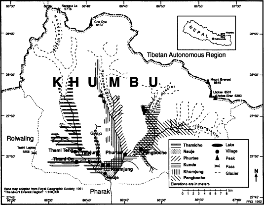
Map 8.
Village Herding Patterns
Gyazumpa and there are some resa at altitudes as high as 6,000 meters. Kunde yak- and nak-herding families, by contrast, rely on the high-altitude pastures of easternmost Khumbu.[26] Most concentrate on the valley of the Lobuche Khola where they share most herding areas with Pangboche families. Kunde families alone, however, use the Melinang area east of Tugla, the Lobuche area, and the higher ground towards the foot of Mount Everest. Some of the differences of emphases in herding areas between Pangboche and Kunde as suggested by patterns of herding-hut ownership can be seen in map 11. Kunde families especially base in the Pheriche-Pulungkarpo-Dusa area in the early summer before this area is closed to livestock and then use the Tugla area for a base. Pangboche villagers make more use of the western side of the Lobuche Khola, the upper Imja Khola valley, and the environs of Pangboche itself. Pangboche herders also use the Yarin area whereas some families from both villages use the adjacent Pulubuk region, as did some Nauje herders until the 1960s.
Communal Regulation of Pastoralism
Since at least the middle of the nineteenth century Khumbu Sherpas have maintained village- and valley-based agropastoral management systems aimed at protecting crops and pastoral resources through controlling grazing and the cutting of wild grass for hay.[27] We have already encountered these systems when reviewing Khumbu agriculture, for the same community nawa officials who implement the regulations designed to protect crops from blight also enforce a form of rotational grazing that protects growing crops from livestock depredation, limits the use of some high-altitude pastures, and protects crucial winter grazing and fodder resources.[28] The system operates on a zone basis. In each valley a set of zones is sequentially opened and closed to specific activities. Opening or closing a zone to an activity such as grazing is known as opening or closing the di for livestock, di being a ban on a certain type of land use. Zonal systems such as this are not common in Nepal and are very rare even among other Sherpa groups.
During the past century five different regional nawa systems have been in operation (map 9). In eastern Khumbu a system of four zones is administered by nawa chosen in Pangboche and Dingboche. In the Dudh Kosi valley there are two different administrative systems, a Phurtse-based one that supervises two zones on the eastern side of the valley and one area immediately across the river from Phurtse and a Khumjung-and Kunde-based system that regulates the use of two zones that extend from these villages as far east as the Mong ridge overlooking
the confluence of the Dudh Kosi and Imja Khola rivers. Nauje had its own set of nawa until 1979, who supervised community agropastoral regulations in a single zone in the immediate neighborhood of the settlement. The rest of the Bhote Kosi valley has been the responsibility of nawa chosen in Thamo, Pare, Thami Og, Thami Teng, Yulajung, and Tarnga. These nawa administer six zones in the lower and middle altitudes of the valley. It should be noted that not all of these systems are "village" pastoral management institutions, for most are actually multivillage institutions. The operation of the livestock bans in the Bhote Kosi valley requires coordination between nawa elected in several different villages, as does the Khumjung and Kunde system. The Imja Khola valley system relies on both Pangboche and Dingboche nawa, and at Dingboche all residents of the community including families from Pangboche, Khumjung, Kunde, and Nauje, hold office in a rotation of responsibilities.
As indicated in map 9 much of lower Khumbu is included in these five different networks. In the Imja Khola and Lobuche Khola valleys a substantial amount of subalpine and alpine pasture area is managed. Elsewhere in Khumbu little high-altitude land is subject to communal constraints on pastoralism. Herding restrictions in most regulated areas are only in operation from late June through mid to late September.
Management zones are opened and closed to livestock, hay and wild grass harvest, and a variety of activities associated with protecting crops from blight. A particular zone can be closed or opened to different activities at different times. It is common, for example, to close the village area to livestock before closing it to all work in the fields and to open it in the early autumn for crop harvesting and hay cutting several days or weeks before allowing the return of the herds. In most cases nawa have little latitude in deciding when to open and close zones. These decisions are generally linked to the Sherpa lunar calendar and the regional festival cycle. The regulations that nawa enforce are also determined not personally but by custom and community decisions. The zones themselves have been defined since before 1900 and are clearly demarcated in local consciousness in terms of particular landscape features.
In most cases nawa are selected by village assemblies, although in some settlements and at some times the real selection has been made by gembu, pembu, or groups of powerful and wealthy families (table 12). In a number of cases there is a rotation system with the office annually reassigned by village election to a different household and no villager allowed to hold office more than one year at a time. Rhoades and Thompson (1975:541-542) have seen in this a parallel with Swiss institutions, but it should be noted that not all Khumbu villages rotated nawa and in some settlements where rotation of office was practiced not all
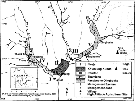
Map 9.
Nawa Management Systems
resident families were necessarily considered eligible.[29] Some Sherpas view the rotation system as an attempt to diffuse the burden of an onerous office. The nawa's work is sometimes jokingly referred to as "crazy job," a thankless obligation that involves immersing oneself in what is bound to be a great deal of trouble policing and fining one's neighbors and relatives. Other Sherpas see the rotation of the job not just as a way to share a distasteful task equitably but as a way in which abuses of power can be minimized.
In most cases nawa are chosen or announced each spring in the fourth month, usually at a village gathering at the end of planting. This commonly is held on the day when the protective ritual circumambulation of the fields is performed. In Pangboche and Phurtse this day also marks the closure of the village to livestock.[30] Elsewhere in Khumbu no zones are closed until during or after the Dumje celebration in the following month. In Nauje, for example, before the system there was abandoned in 1979, the village was always closed to stock during the week after Dumje. It is up to the nawa to meet and choose the exact day, which is usually announced several days before the deadline. Any stock still in the area after the deadline are subject to fines. After closing the area to grazing the nawa become responsible for responding to reports of viola-
Table 12 . Khumbu Communal Pastoral Management | |||
Place | Total Zones | Total Nawa | Altitudinal Coverage |
I Nauje | 1 | 3 | Low altitude |
II Khumjung-Kunde | 2 | 4 | Low altitude |
Khumjung | 2[*] | 2 | Low altitude |
Kunde | 2 | 2 | Low altitude |
III Phurtse | 3 | 2 | Low to middle altitude |
IV Thamicho | 6 | 12 | Low to middle altitude |
Pare | 1 | 2 | Low altitude |
Thamo | 1 | 2 | Low altitude |
Thami Og | 1 | 2 | Low altitude |
Thami Teng | 1 | 2 | Low altitude |
Yulajung | 1 | 2 | Low altitude |
Tarnga | 1 | 2 | Middle altitude |
V Imja Khola | 4 | 4 | Low to high altitude |
Pangboche | 3 | 2 | Low to middle altitude |
Dingboche | 1 | 2 | Middle to high altitude |
Low altitude defined as below 4,000m | |||
Middle altitude defined as 4,000-4,500m | |||
High altitude defined as above 5,000m | |||
* Kunde and Khumjung nawa share responsibility for these zones. | |||
tions and policing the zone if they consider it necessary. Nawa seek out offending Sherpas or the owners of ban-violating livestock and demand compliance with the regulation and the payment of a fine. Livestock owners are required to offer the officials chang (the local beer), and sometimes also pay a small fine that is usually put toward village projects such as maintaining temples, bridges, and trails. Fines escalate in size with continued refusal to comply. Nawa can do no more, however, than issue further fines. They are not authorized to confiscate livestock. If someone refuses to comply with repeated warnings a nawa can inform other community members of this. Community social pressure generally ensures compliance with the regulations.
All Sherpas are required to obey the nawa's injunctions regardless of whether they are residents of a particular valley or not. This responsibility balances the right given to all Khumbu Sherpas to make use of all pasture lands in the region regardless of their village affiliation and the boundaries of particular villages. In order to make allowances for herders' occasional needs to cross through zones that have been closed to grazing all herders are permitted to remain with their stock a single night
within the boundaries of a closed zone. This privilege is sometimes abused, however, when stockkeepers judge that they can escape the notice of nawa for a few additional days. All owners of livestock who are found violating a local zone closure are subject to the same fine regardless of whether or not they are "outsiders." The same regulations have also been applied to non-Sherpas making use of Khumbu for summer transhumance. In former times when Gurungs herded in Khumbu they were also expected to adhere to the nawa's regulations in the areas in which they were allowed to herd.
Regional Grazing and Fodder Resources
The summer richness of the Khumbu high-country pastures has historically attracted transhumant shepherds from lower-altitude regions as well as fattened Khumbu herds. But winter and spring are a far more challenging time, and for at least a century the numbers of livestock kept by Sherpas have exceeded regional range carrying capacity during these times of the year. Half a century ago Khumbu herders, like those in much of the rest of the Himalaya, responded to this seasonal scarcity of grass by migrating out of Khumbu to areas that offered better grazing. Many of Khumbu's nak and yak were taken across the Nangpa La to Tibet where the winter grazing is far superior and Gurung shepherds returned with their flocks to their homes in the lower Dudh Kosi valley. The current Sherpa pattern of year-round herding in Khumbu is a twentieth-century accommodation to social and political factors rather than to environmental conditions. During the past sixty years herders have developed new fodder resources rather than scale back stock-keeping. Yet despite their efforts to put in large stockpiles of wild grasses and herbs and cultivated hay many herders risk serious losses each winter and early spring when heavy snowfalls can lead to a shortfall of fodder and the starvation of even such hardy stock as yak.
Khumbu range resources vary with altitude, season, aspect, micro-climatic conditions, and grazing pressure. Much of the skill of herding lies in evaluating local range resources and guiding stock through a number of finely timed moves among grazing areas. Through many generations of experience in particular valleys herders have developed an intimate knowledge of microregional and temporal variations in pasture quality. This knowledge is but one of a number of different elements that influence decisions about the annual round of herd movements. But, like the more formalized operation of the community pastoral management institutions, such local knowledge represents an adaptive link between environmental perception and pastoral practice.
Khumbu valleys provide pasture at several distinct altitudinal levels. The south-facing slopes of the gorges of the lower valleys below 3,800 meters offer rangeland grazing and open woodland foraging that is especially useful to crossbreeds, cattle, sheep, and goats during winter and spring. While northern-aspect slopes in this altitude range are often densely forested and relatively little grazed, the southern-aspect slopes offer vast expanses of grass and shrubs that are a major pastoral resource. Above 3,800 meters there is good summer grazing in the large expanses of subalpine and alpine grassland on the floors and slopes of the wide, glacier-carved upper valleys. There is also good grazing in this season on the slopes of long-stable lateral and terminal moraines. The quality of grass and other palatable forage in a particular pasture or woodland area varies from year to year, but some places have long-established reputations for offering fine grazing at particular times during the year. The quality of the grazing is considered to reflect not only seasonality, altitude, local rainfall, aspect, and level of grazing intensity, which affect the grass itself, but also local shade and ground moisture conditions that are believed to affect the health of the livestock. Wet and muddy sites are believed to lead to hoof infections and stomach problems whereas shady sites are thought to cause stock to lose their conditioning as a result of their spending more time resting and less time eating.
Khumbu cattle, including yak and nak, must be fed fodder in order to survive the winter and early spring. Like other Himalayan peoples Khumbu Sherpas make use of field residues. In the autumn livestock are turned into the barley fields to graze on the field stubble. Buckwheat and barley stalks are carefully dried and stored to feed to stock in winter and spring, and surplus tubers are also given to them. A small amount of fodder, especially bamboo, is also obtained from local woodlands and forest.[31] These resources, however, are inadequate for the levels of stock kept in the region and herders instead rely primarily on hay. This is obtained in two ways. Wild grass (ri tsa , mountain grass) is cut and dried from meadows that have been protected from grazing in the late summer. Hay (tsi tsa ) is cultivated in stone-walled fields. The production of cultivated hay on the scale harvested today in Khumbu is rare elsewhere in the Himalaya, and hay is not cultivated in the adjacent part of Tibet.[32]
In Khumbu hay is grown from 3,400 meters to as high as 4,700 meters (map 10), with most of the area in hay situated above 4,000 meters. In the high-herding settlements of the upper valley hay is the primary crop and in many of them it is the only thing grown. The highest settlements with walled hay fields are Bibre (4,600m), Dusa (4,503m), Gokyo (4,750m) and Apsona (4,600m). There would undoubtedly be considerably more land in hay today, given the scarcity of fodder regionally,
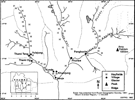
Map 10.
Hay Cultivation
except for the government policies that prohibit agricultural expansion. Some land was surreptitiously put to hay in the 1960s and 1970s and in some Thamicho villages land is now being taken out of food crops and put to hay.
Khumbu hayfields are normally planted only once. The autumn before a hayfield is to be established herders collect the seed of wild grasses that are preferred for hay. The following spring a field is plowed from pastureland and then sown with the wild grass seed. The final step is to erect a stone wall for protection against livestock.[33] Once they are established hayfields need only be manured annually. Each spring nak and yak are corralled at night on the hayfields to collect their manure and dung is also gathered from nearby slopes. Some families, however, begin collecting manure as early as the previous autumn. This dung is first pulverized and then spread thinly over the field. Little else is done to encourage a productive yield. A few families weed hayfields of plants that are unpalatable to stock, but most herders do not bother. Until recent Sherpa experiments in Nauje and the upper Lobuche Khola valley there was no irrigation of hayfields.
The main effort in haymaking comes at harvest. Sherpas consider the cutting, drying, and storing of hay to be some of the hardest agricultural
work of the year. Both men and women cut hay, but most of the work is done by men. This may in part reflect the fact that women are usually busy with potato and grain harvesting at this time of the year. It requires a full day and a group of five workers to cut the grass on a single 500-square-meter field. The grass is laboriously cut by the handful with a sickle. This can be dangerous work, especially when the grass is short and the sickle must be wielded close to the hand grasping the grass. When the grass is high the work goes much more quickly, for less care has to be exercised to avoid accidents. Households normally cut hayfields near their homes themselves, but it is very common to hire help for more distant fields. Arrangements for laborers must be made several weeks ahead and relatively high wages must be paid. Wages are paid by the field cut rather than on a daily basis and the price agreed on usually does not include labor for drying or storing. Payment is often in butter rather than in cash.[34] Usually the field owner is also obliged to provide food and drink for laborers. Once cut the grass is spread on the field for several days to dry and then stored indoors. Sunny weather is critical to this operation.
Hay made from wild grass is also stored in large quantities. Vast areas of lower Khumbu pasture are protected from grazing for much of the summer and some high-altitude pasture areas in the upper Imja Khola and Lobuche Khola regions are also protected for a few weeks in late summer. The grass in these areas grows long, and a week or so before the nawa announce the reopening of these zones for grazing they are first opened for grass cutting. Men and sometimes also women move about the countryside with huge baskets and long knives cutting the green grass and then hauling it back in baskets to the herding huts and main houses to dry and store. Throughout the region there is real competition to gather as much as possible from the most convenient areas, and in recent years there have been many cases of people defying the nawa in order to start harvesting grass a few days earlier than the rest of the community. Harvesting begins in the Nauje area as early as late August (August 18 in 1987) now that there are no nawa there to forestall grass cutting until the pasture grass is mature and seeding.[35] In most of the rest of Khumbu there are still grass-cutting regulations. Here the high-altitude grass is cut first, ahead of the herds that descend the valleys in sequence with the opening of the various zones to grazing. In the Dudh Kosi valley, for example, grass cutting in hayfields and pastures begins in unregulated areas such as Gokyo and Na in the high reaches of the valley in mid-August (August 15 in 1987). In late August (August 24 in 1987) the grass- and hay-cutting restriction at Konar is lifted and shortly thereafter hay making commences around Phurtse itself.
Families who herd cows and crossbreeds often do not cultivate hay.
Their stock requires a good deal of fodder in winter and in early spring, but households with just one or two animals can usually meet most of this requirement by collecting crop residue, grass from around the edge of fields, and wild grass and other fodder.[36] Households with more cross-breeds and cows, or that have less time and energy to collect wild fodder, may have to use some hay. A few Nauje families in this situation now cultivate hay in the Bhote Kosi valley at Samde, Tashilung, and Tarnga.[37] They and other families also rely on purchasing some hay, primarily from Thamicho villagers. Although Brower (1987:262) has suggested that zopkio are quite cheap to keep and require little fodder feeding, the experience of some Nauje herders is different.[38] Here it is considered ideal to feed urang zopkio four to five kilograms of wild-grass hay in the morning and again in the evening (as well as providing bantsa , household scraps, and kole , a grain porridge) when the pasture is poorest in spring, and the survival of stock depends on fodder supplies.[39] But many owners are unable to collect sufficient wild grass for hay even by augmenting their family's efforts with hired labor. They find themselves obliged to purchase hay from those with a surplus to sell. Nauje families especially look to Thamicho families for hay. When possible Nauje families make agreements during the summer for hay that will be cut that autumn, for this can be obtained at lower prices. By the end of the 1980s, however, fewer Thamicho families were willing to make such deals, preferring to sell in the autumn at higher prices. There is also increasing importation of hay from Pharak, although it is widely agreed that Pharak-grown fodder is lower in nutritional value than that produced in Khumbu.[40]
Field-grown hay is more expensive than hay made from wild grass, for it is considered to have more energy as livestock fodder. The most costly of all is hay from high-altitude fields (phu tsa ). This is believed to have more energy than hay made from the same grass species but grown lower in Khumbu (rong tsa ). In 1987 the going rate was 100 rupees per forty-kilogram load for fodder of mixed hay and wild-grass hay, a price then equal to two or three days' wages for portering. This, however, was the price for hay that was paid for in advance during the summer. The price had risen to 150 rupees per load by cutting time. By spring two hundred rupees was thought to be a very reasonable price and could be obtained only if one picked the hay up at the site rather than had it delivered. Prices also vary regionally depending on the quality of the harvest in a particular year and the dynamics and anticipated dynamics of supply and demand in a given place. In spring 1986 hay was 250 rupees per load in Kunde and at Dingboche it reached 300 rupees. But even at these prices it was nearly impossible to obtain in any quantity.[41] By autumn 1990 hay prices had increased yet further. In Thamicho
advance-contract hay was 150 rupees per load and was being sold in October-November for 300 rupees per load on the open market. Pangboche hay was 400 rupees per load in November 1990, 150 rupees more than it had been at that time the previous year, and was expected to increase to 500 rupees per load the following month. In Nauje in 1991 hay was selling for 500-600 rupees per load, and small amounts were available from people with hayfields at Pare, Tesho, and Samde.
Yak and nak herding are considered to require hay growing. This is entwined with herding patterns and the ownership of herding huts in pasture areas far from villages. Hay is rarely transported in large quantities to main villages and instead is stored in the high settlements where secondary houses reflect the need to have both a secure storage place to keep hay dry and a place for herders to base during the bitter months of winter. The winter migration of nak and yak into the high country results from a simple shortage of grazing and fodder in the main villages and the fact that it is more practicable to bring the livestock to the hay than to haul it back down to the main village. Hay is occasionally brought to the village when a family considers it important enough to go to the trouble in order to be able to stay on in their main house for a few days or weeks longer. The time and energy required to transport large amounts of hay, however, limits this practice.[42] In spring the location of hay stores and hayfields patterns herd movements. This results both from the need to take the stock to the places where fodder has been stored and keep them there while supplies last and the need to fertilize the hayfields each spring.
Herding Patterns
Seasonal pasture use and patterns of annual pastoral movement among pastures reflect herding households' resources of land, labor, and capital, herd size and composition, the location of pastures traditionally used by one's fellow villagers (and in some cases also by nonvillage kin), the operation of the nawa system, lifestyle preferences, family customs, and a number of other factors that vary in importance from family to family and herder to herder. Pastoral movement patterns also reflect processes of past and present environmental adaptation at both the level of individual decisions and the development of collective resource-management institutions. The definition of community management zones and the timing of their opening and closing to livestock grazing and hay cutting reflects an intimate awareness of local range resources. Broad seasonal herd movements and day-to-day decisions about grazing represent evaluations of opportunities and risks that are also based on profound local knowledge of pasture conditions, climate, predators, and the requirements and capabilities of stock.
Pastoral movement patterns are discussed in depth in the remainder of this chapter. First the annual round of pastoral movement is explored as it relates to local knowledge about range conditions and livestock, the operation of the nawa system, and other factors. Then I discuss in detail the contrasting herding movements of two families, one from Kunde and one from Pangboche, who both herd nak in the upper Imja Khola and Lobuche Khola. This highlights some of the factors herders consider in their movement decisions and the ways in which different household priorities and resources can result in different patterns of pasture use that nonetheless also embody generally similar seasonal and altitudinal strategies.
The Annual Round of Transhumance
Seasonal movements of livestock to different Khumbu altitudes and microenvironmental regions are based above all else on evaluations of the fitness of different types, genders, and age groups of stock for different climatic and pasture conditions. Different general patterns of herd movements can be identified for several basic types of local pastoral styles and herd structures. For several types of stock raising, including the keeping of crossbreeds and common cattle, the annual round of transhumance is very similar to the summer movement into the high pastures and the winter retreat into lower-altitude regions that is so common in mountain regions throughout the world. But this is not the case for yak and nak. Yak and nak are well enough acclimated to the high Himalaya that they can cope with even the higher-altitude regions in the height of winter.[43] This offers possibilities for a rather different type of pastoralism in which seasonal altitudinal shifts are less pivotal to transhumance than movement based on other factors.
The seasonal shifts of herd movements for these different styles of transhumance can be traced from any point in the annual round. Two points in the cycle, late summer and the weeks of late autumn and early winter, are perhaps a more convenient starting point than others. Only at these two times are all Khumbu stock located in roughly similar regions, in the middle- and upper-altitude pastures during late summer and in the main villages in late autumn and early winter. I will trace the round beginning in late autumn (fig. 13).
Virtually all stockowners bring their herds down to the main villages during the clear, cool, late-October and November weeks following the end of the potato and buckwheat harvest and hay making. The zone around the main villages is then open to grazing for the first time since it was closed to protect the growing crops from stock depredations back in
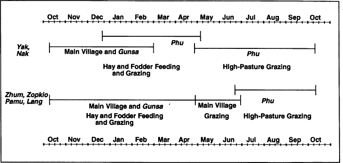
Figure 13.
Pastoral Cycle
late spring or early summer, and there is good grazing on grass that has been protected for several months. Families which have cultivated grain may also allow their herd to graze on crop stubble, which contributes to field fertility as well as nourishing the livestock. Families which live in two-story houses begin to stable stock overnight in the lower story of the house, putting forest leaves and needles underneath them to be enriched by their urine and dung and composting this outdoors for use in the spring.[44] As the weather grows colder and the first snows fall in late September or October, indoor stabling becomes necessary for cross-breeds and cattle, although yak can remain outdoors.[45] During the days the herds are led out to graze adjacent rangeland and woodland.
As winter settles the grazing becomes less rich in the lower valleys. Stock are still led out to graze the lower Khumbu grass and shrublands and to forage in the forests, but it is taken for granted that both cross-breeds and ordinary cattle will begin to require supplementary fodder by November and that they will have to be fed large amounts of fodder until June. What fodder is fed them depends not only on availability but also on many beliefs about the appropriate forms and amounts of fodder to be given to particular types and ages of stock. Depending on the condition of the grazing near the villages, yak and nak may be shifted to new herding bases as early as late November or as late as January. They are moved up into areas of the upper valleys at this time to which cross-breeds and cattle will not be taken until June or later. In the era when Khumbu stock was herded in Tibet in the winter it was not necessary to feed yak or nak supplementary fodder during the winter months, for they were fully capable of subsisting on senescent grass. This is not possible today. Herders must feed fodder to both yak and nak to supplement what grass the stock can find uncovered by snow or reach by pawing through a thin snow cover. Herders move their nak and yak during these months among the places where they have stored hay during the autumn, staying in each as long as fodder supplies hold out. Even for yak, however, some areas are considered too cold in mid-winter. It is not usual, for example, for Thamicho herders to take yak to Tengbo in the upper Thami Chu valley in mid-winter. This area is considered to be too cold for stock since it is situated in a very narrow valley that gets little sun during mid-winter months. Yak and nak are only driven up to Tengbo in the spring.
Fodder becomes important for yak and nak in December. During the remainder of the winter they are given hay on a daily basis, and the amount of fodder given them increases as winter continues. At first only pregnant stock are given supplementary fodder, but soon all are given a ration. In early winter nak and yak are given hay once each day in the evening. By January, when the coldest days of the year come on, two
feedings of hay per day are necessary. Pregnant nak now are given fodder three times per day. In February and March nak and yak are still fed hay twice per day, but as supplies run short the amount given during each feeding is decreased. In many years hay feeding continues to be necessary into April or May depending on weather, snow cover, grass, and hay stores. All other stock are also fed fodder in the winter and often receive not only hay but also bantsa, a mix of household refuse and grain.
The arrival of spring finds the same contrast between yak and nak at the higher altitudes and other stock stabled in the villages. Yak and nak movements during March and April remain strongly related to the availability of hay stores in different areas. An additional factor now, however, is the need to manure hay and high-altitude secondary crop areas. Both these priorities keep the movement of the herds geared to the location of household hay stores until supplies are exhausted. For yak and nak these are the difficult months when hay begins to run short and the new grass has not yet arrived, the time which Sonam Hishi calls the "months when rich men cry." In bad years stock may starve. In the worst recent years some herders have lost half their herd.
By May the new grass is returning. The key to the quality of the grass (and to the coming autumn's hay crop) is considered to be the amount of spring rain in April and May. Some people consider the rainfall in May to be the crucial factor. If there is no rain during those months both grazing and hay will be bad. Some places such as Pulubuk and Dzongla are noted for having better grass even in dry springs due to particularly rainy microconditions. Gyajo, a narrow valley just north of Kunde and west of the sacred mountain Khumbila, is also sometimes used as an emergency grazing area. The U-shaped floor of the valley offers limited pasture at an altitude of 4,000 meters, which some Thamicho herders resort to in springs short of fodder.[46]
In late spring major differences can be seen in the way in which different types of stock are moved to exploit new grass. Yak and nak are taken high to places such as Chukkung, Mingbo, Dzongla, Gokyo, Charchung, Arye, and Chule, where they can use their unique ability to lap up extraordinarily short grass that is beyond the capability of cross-breeds or cattle to graze. Other stock are kept in the main village, but the need to feed them fodder is past.
At the outset of Dawa Nawa, the fifth month, in June or early July, herd movements may reflect a herder's interest in being close to the main villages for the Dumje celebration. Many Pangboche herds, for example, are brought back down to lower altitudes for this occasion. Yak and nak may be taken to Yarin, Ralha, and Orsho in the Pangboche area. Herds remain in Yarin and other nearby areas until after Dumje when the area around Yarin is closed to livestock.
After Dumje there is much new grass in the high country. During the rest of the summer herd movements hinge on perceptions of the altitude fitness of the herds, the closure of zones to grazing, and household priorities as to where to be based at the time of the Yerchang festival.[47] During the summer yak and urang zopkio are considered to be capable of subsisting on their own in the highest, remotest pastures in Khumbu. Yak especially are taken up into the high corners of Khumbu and turned loose for weeks, and yak and nonmilking nak can be found during midsummer in the uppermost Imja Khola valley far beyond Chukkung and above Tarnak and Gokyo in the Dudh Kosi valley. Less remote and slightly lower areas such as Gyajo, Tengbo, and Langmoche are very popular for turning zopkio free to graze on their own.
The timing of herding in different parts of the upper valleys may vary, reflecting perceptions of the value of grass in different places as well as household circumstances such as ownership of huts and resa. Considerations about the state of the grass must be tempered also by other evaluations of grazing conditions. Some places such as Dzongla, Tugla, and Pulubuk have a reputation for being especially rainy areas and some herders do not consider them healthy places for livestock.
Cows and zhum may also be taken high in summer. Zhum, for example, are taken as high as Chukkung. Some people note that in the summer zhum can be taken anywhere where nak are herded. Cows are also herded at relatively high altitudes, although I have not seen them as high as 5,000 meters. Zhum and cows, however, are not always herded at high altitudes in summer. Many families, on the contrary, take them to places such as Mong, the Omoka-Pulubuk area, and Ralha which are just outside of the closed zones. Kunde (and formerly Nauje) zhum are often taken to Pulubuk in the summer, and more than fifteen Khumjung and Kunde families with zhum and cows base themselves at Mong and nearby places.
In autumn the lower-valley zones are reopened to grazing and all stock are brought back down valley. They now graze areas adjacent to the main settlements which have been closed since at least July. Cows and crossbreeds stay based in the main villages until summer. Yak and nak, by contrast, shift grazing locations considerably during the following months. They are usually herded at the altitudes of the main villages in late October for a month or two. In late autumn they may be taken briefly to the high country to graze on the grass that grows up following the cutting of the hayfields. They are then returned to the main village for a few more weeks or months until the move is made to return to the high herding huts for the remainder of the winter. The timing of the winter move varies. Pangboche herders may move yak and nak up valley in December. Some Thamicho herders may begin even earlier, going up
valley for the grass that grows up after the hayfields are cut, then grazing the high valleys wherever they judge the grass to be good until they are forced to begin feeding the stock fodder and must base in herding settlements where they have hay stores. Other stock owners may delay the up-valley move and keep their herds in the lower Bhote Kosi valley into December. Phurtse herders move their stock up valley rather late, usually in mid-February. Once moved up to high altitude in winter, nak and yak remain until autumn unless they are brought down briefly in the spring to graze new grass or at Dumje time.
The herding pattern outlined above is probably an old one for cross-breed and cow owners regionwide, and has also been long used by Phurtse and Pangboche herders who have relied on the cultivation of hay and on year-round herding within Khumbu itself. Many large nak herders of Khumjung, Kunde, Nauje, and the Thamicho settlements, however, historically relied much less on hay and sent their stock to Tibet for the winter rather than to high-altitude herding settlements within Khumbu.
Communal Regulations and the Timing of Herding Patterns
The opening and closing of livestock-management zones in parts of the Khumbu valleys during the summer and early autumn establishes a limited form of rotational grazing that gives a basic shape and timing to herd movements in all the valleys for three to five months of the year. The operation of the nawa system does not prescribe a fixed pattern for regional herding. Families still exercise considerable choice over their herd movements. Many families decide to move their stock into other areas before a particular zone is officially closed by the nawa, and in some years a few families choose to move their stock into zones before they are officially opened. But the sequential closing and opening of zones to grazing certainly is a major factor in herding decisions and transhumant patterns during the months when the system is in effect.
The first closures of zones to livestock take place in eastern Khumbu in May when all stock is excluded from the immediate vicinity of Pangboche and Phurtse following the end of planting and the ritual Tengur circumambulation of the fields (map 11).[48] Elsewhere no areas are closed until June and the time of the Dumje festival. The zones of lower Thamicho are the next to be closed, an event that takes place each year on the tenth day of the fifth month in the midst of the Dumje festivities.[49] Nauje and Khumjung-Kunde close the area in and around their villages to grazing only after the end of Dumje.[50] Since the date when villages are closed to grazing is tied to the lunar calendar the date
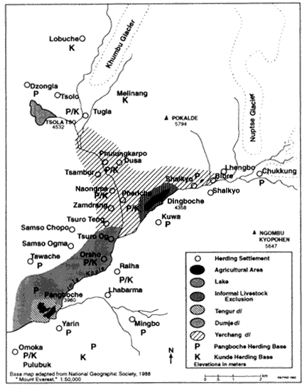
Map 11.
Imja Khola Pastoral Management
of closure can vary from year to year by several weeks. In some years Dumje and the closure of the village to stock comes in June, in other years well into July.
There are usually enough families in the lower-altitude Khumbu villages who keep their cows and crossbreeds in the villages until the last possible minute that there is a general upward movement of people and
stock to the high country just before the lower valleys are closed to grazing. The stock spend the rest of the summer up valley until after the main village crops have been harvested.
Within a few days after Dumje the nawa in Khumjung and Kunde announce that the area around the villages will be closed to livestock five days hence. All stock must be gone from the zone near the villages and the gunsa of Teshinga by the first day of the sixth month, two weeks after Dumje. Nauje nawa also formerly announced the imminent closure of the village area to stock just after Dumje and also gave a five-day notice that they shouted out from the top of a big rock in the center of the settlement. In Thamicho, before nawa regulation was abandoned in the late 1980s, the lower Bhote Kosi valley was closed before Dumje as far north as the bridge just south of Thami Og, and after Dumje the ban on livestock was extended as far as the Mususamba bridge on the Langmoche Chu. Phurtse stock at this point in the year have already been excluded from the settlement, but now the herds must also be cleared from the lower valley to a point beyond Konar. The summer livestock ban at Pangboche has similarly closed the area immediately adjacent to the village for several weeks before Dumje. Now Yarin and other areas of the lower Imja Khola are closed.
Families choose their own moving day from within the period allotted before the zone is closed to grazing. The day chosen by each family usually is a day of the week or a particular date that is considered particularly auspicious. This may be one of the days considered lucky each month, such as the fifteenth, the day of the week that is lucky because it was the day on which the head of the household was born, or a day that has been determined to be lucky by consulting horoscopes or a Tibetan farmer's almanac. On the morning of the move juniper boughs are burned outside the house sending fragrant clouds of smoke skyward. To this offering the family head adds a few prayers, and then the windows are latched and the door locked and the family sets out on foot, driving their stock ahead of them and leading a few yak or zopkio laden with the household goods and supplies they will require for the summer. The lead member of the party carries a prayer flag on a length of bamboo. This will be set up at wherever the family settles and is moved with them during the summer from herding hut to herding hut.
For the next three or four months families camp out in the tiny herding huts and resa, moving from pasture to pasture according to their own whims and perceptions of pasture conditions. These high country months are a time of the year that many look forward to eagerly, a time of green slopes sparkling with wildflowers, crystal mornings beneath the great peaks, plentiful milk and yoghurt, and, best of all for many people, freedom from the gossip, factionalism, and social demands of village
life. Up in the high-herding settlements there is time for life to revolve around one's own family and those of a very few neighbors.
Once beyond the border of the closed zone a family may set up its base wherever it chooses and some families go little further the entire summer.[51] Other families move between a number of high-herding huts and temporary resa. Only in the Imja Khola area does anything other than family decision making dictate any particular structure to the rest of the summer's movements. Here the operation of another livestock-exclosure zone closes a large area of good grazing ground after the Yerchang festival one month after Dumje. Most herders tend to herd in this zone until it is closed and usually base at this time in the settlement where they will celebrate the festival. Family custom and preferences for whom they want as neighbors at the festival have a good deal to do with the choice of site.
In most of Khumbu Yerchang is a major event combining communal rituals with an intense period of socializing.[52] The festival consists of a day of rites, several of which involve prayers believed to ensure the health and prosperity of the herds. All the members of a herding settlement, regardless of home village affiliation or clan, gather together to offer prayers to the great god Khumbu Yul Lla and the other deities of Khumbu. These rites include the dedication of torma (consecrated flour and butter images) representing the livestock associated with Khumbu Yul Lha: yak, sheep, and goat. At this time some families may make some of their livestock chetar , dedicated to the gods, and these animals are hence forever free of the threat of being killed by humans.[53] The crowning event is a rite in which each household plants a pole bedecked with prayer flags at a common outdoor shrine.[54] A number of days of celebration follow. Each family in the settlement hosts a party at its hut. One party takes place each day until the round is completed. The celebration of Yerchang thus marks one of the most intensive communal periods of the year, a time of major interaction with a few families in shared ritual, feasting, drinking and dancing. Yerchang is only carried out at certain high-herding settlements, and families choose where they want to celebrate it largely on the basis of the people with whom they want to share the festival. Most families return to the same place each year making this one of the few fixed points in the pastoral calendar.[55]
Herders in most of Khumbu may simply remain where they are after Yerchang since no further livestock exclosures are implemented. Many families in these areas, however, shift base, generally moving farther up valley if they have places there. In the Imja Khola and Lobuche Khola areas herding families must disperse after Yerchang due to the subsequent closing of most of the Yerchang sites to grazing. For the next six weeks or more most herders in the upper Imja Khola and Lobuche Khola valleys
move up into the highest-altitude areas of eastern Khumbu.[56] Within this remaining open area families are free to move as they will, and the places most popular for grazing vary slightly from year to year. Kunde families emphasize the Tugla area in some years, for example, and in other years move to Melinang when the grass is best there.
The opening of areas closed to livestock in September and October influences herd movements in all the valleys. Although no herder is obliged to move his herd into an area simply because it has been opened, in practice most herders are eager to let their stock graze areas that have been protected from grazing for as many as three months. Some are indeed all too eager, and nawa are kept busy issuing reprimands to those whose stock violate the final days of the grazing ban. In each valley several zones are sequentially opened and livestock accordingly move down valley in several stages, all of which takes place within a two- or three-week period between late September and mid-October. Usually each zone is opened first for grass cutting and a flurry of activity then takes place as hay is harvested and wild grass cut. Zones where there are also agricultural sites are next opened for harvesting, and only then are livestock permitted to enter them.
In the Bhote Kosi and Dudh Kosi valleys there are, or recently were in the case of Thamicho, fewer stages in the down-valley pastoral migration than in the Imja Khola valley. In the Dudh Kosi valley Tarnga was opened first, then all the area down to the bridge below Thami Og, and finally the lower valley. Hay and crop harvests preceded herding in each of these areas. In the eastern Dudh Kosi area the timing of the opening of the zones to various activities is based on the ripening of the first buckwheat in Phurtse in certain fields in the center of the village. In 1987 the first white buckwheat grains were seen here on August 19. Five days later the cutting of hayfields and of wild grass was allowed in the Konar area. Normally this might have been allowed somewhat sooner, for in this year the opening was delayed to coincide with an auspicious day. On September 10 that area was opened to livestock and Phurtse was opened to potato harvesting. Buckwheat harvest began on September 23 in Phurtse and the area was then also opened to cutting wild grass. On October 1 the area between Phurtse and Pangboche villages along the Imja Khola valley (but not including Phurtse itself) was opened to livestock. The settlement itself was finally opened to stock on October 10 following the completion of the buckwheat harvest. Khumjung stock move first into the area just north of Mong once Phurtse has lifted the seasonal ban it enforces there on grass cutting and grazing, then into the Teshinga area once that area has been opened to grass cutting and harvest at the gunsa has been completed. The ban on livestock in Khumjung and Kunde itself is the last to be relaxed, an event that takes
place in mid-October after the completion of the buckwheat harvest and most of the potato harvest. The management of livestock exclusions in Nauje, before this was discontinued in 1979, was the simplest system of all. Here there was only a single zone to be concerned with. Grass cutting was allowed in September, after the fifth day of the eighth month, Dawa Gepa. The exact date was chosen by the nawa with regard to the maturity of wild grass for hay making. The area was reopened to livestock in October, Dawa Guwa, following the harvest.
The process in the Imja Khola valley is somewhat more complex. Here there are more zones involved and the harvest at Dingboche also complicates the sequence. The high-altitude zones in the upper Imja Khola and Lobuche Khola valleys are opened first, in the reverse sequence of their closure. Each is opened first for wild grass and hay cutting and only then for herding. The order of these openings is fixed and the timing between the opening of different zones for different activities throughout the valleys is scheduled according to a standardized, lunar-calendar-based sequence. The sequence is initiated by the arrival of mid-summer which, according to the Sherpa reckoning of the seasons and their relationship to the lunar calendar, can come rather late in the year. In 1987 the mid-summer point in the Sherpa calendar came on September 1. When mid-summer arrives the first zones in eastern Khumbu begin to be opened for grass cutting. The Ralha area comes first in the sequence.[57] A week later, on September 7 in 1987, grass cutting is allowed in the zones that were closed after Yerchang. A week after that (September 14, 1987) these zones are opened to grazing. On this day the nawa also allow the barley harvest at Dingboche to commence.[58] Precisely one week later Dingboche is opened to grazing. In 1987 all families had completed their harvest here by that date except for one, which finished the work by mid-afternoon. Dispatch is important in order to avoid crop loss, for large numbers of livestock are immediately moved into the area as soon as it is opened for grazing. Despite the relatively late start of this sequence of zone openings in 1987 barley was still harvested somewhat earlier than Sherpa farmers would have preferred. Khumbu barley is always harvested several weeks before it fully ripens, perhaps as a safety precaution against damaging weather in October or simply as a compromise in order to allow the grass cutting, crop harvesting, and transhumant cycles in the valleys to proceed more smoothly. But the 1987 harvest had to be carried out when the grain was even less mature than usual. Some farmers noted that harvest took place at the right time on the calendar but at the wrong time according to the plants.[59]
After stock return to Dingboche there remains only the lifting of the remaining grass- and hay-cutting, crop-harvesting, and grazing restric-
tions in that reach of the Imja Khola valley between the confluence of the river with the Lobuche Khola at the Dolimsampa bridge and the Pangboche area. A week after stock moved into Dingboche, on September 28 in 1987, many herders moved their stock down valley beyond the Dolimsampa bridge into the remaining two zones outside of Pangboche.[60] Pangboche itself was opened to grazing on October 9, after all the buckwheat and most of the potatoes had been harvested.
Family Herding Patterns
The patterns of herd movements already discussed are broadly characteristic of most herding families in Khumbu. This level of generalization illustrates a number of the important factors involved in household decisions about herding. But a closer inspection of the decisions made by individual families is necessary to appreciate the complexity of factors that herders must weigh. All the herders from a given village do not simply all take their stock to the same areas where the grass is good and the areas open for grazing. Individual families may even follow different herding patterns from year to year. Yet for all the complexity of household pastoral movements key factors in their herding strategies can be identified and generalizations at this microlevel can be made about the seasonal movements up and down the valleys. As an example of this the following section compares and contrasts the herding decisions and pastoral movement patterns of two families who herd nak in the upper Imja Khola region. One family is from Kunde, the other from Pangboche.
Both of these households are well-to-do by Khumbu standards. Both are only minimally involved in tourism and concentrate instead on crop growing and herding. They both also predominately herd nak and sell crossbreed calves. Each has a herd that is large by Khumbu standards. The Kunde family, one of the six families in that village who herd nak, owns four yak, sixteen nak and ten other head of cattle (urang zopkio, zhum, cows). It has herding huts at Lhabarma, Dusa, Orsho, Dingboche, Pheriche, Phulungkarpo, and Teshinga as well as resa at Dzongla, Tsola, and Melinang. As one of the largest stock-owning families, the Pangboche household has about twenty-five head of cattle, primarily nak, herding huts at Dingboche, Bibre, Selum Che, Yarin, and Chukkung, and resa at Mingbo and Pulubuk. The following account focuses on the movement of the nak.
By early spring the stock of the Kunde family, like that of the other three Kunde families who herd nak in eastern Khumbu, is already in the high country, where for some weeks it has been driven between the places where the family owns hayfields and keeps hay stored in huts. The amount of time spent at each of these varies from year to year with
Table 13 . Household Herding Pattern (Kunde ) | |
Midwinter/Spring | |
December/January through May | |
Dingboche | 20-30 days |
Orsho | 30 days |
Pheriche | 15-30 days |
Lhabarma | 30 days |
Phulungkarpo | 20-30 days |
Dzongla | 15-30 days |
Summer | |
June through August | |
Dzongla | 30 days |
Dusa | 30 days |
Tugla/Melinang | 30 days |
Autumn | |
September through November | |
Tugla | 7 days |
Pheriche | 7 days |
Dingboche | 14 days |
Orsho | 14 days |
Kunde | 45 days |
Early/mid-Winter | |
December through January | |
Kunde | 45 days |
Dingboche | 20-30 days |
that year's hay harvests and is just long enough to finish the fodder and contribute as much manure as possible to the hayfields to promote the coming year's growth (table 13). Each family has its own route and all do not share the same herding settlement bases. In most years the first stop of the family we are following is Dingboche. Here the herd is based for twenty to thirty days in late autumn and early winter in Dawa Chuchikpa and Chuniwa , the eleventh and twelfth months of the Sherpa calendar. The length of time spent herding here depends both on the snow cover and the amount of stored fodder that is available. From there the herd is moved on to Orsho (one month), Pheriche (two weeks to a month), and Lhabarma (one month). The final move of this sequence is to Phulung-
karpo where the nak are pastured for twenty to thirty days. Here they finish the last of the hay in May, Dawa Shiwa. This movement pattern also enables the family to manure their hayfields at Orsho, Pheriche, Lhabarma, and Phulungkarpo and their crop fields at Dingboche.
All four Kunde nak owners complete their spring herd movements at Phulungkarpo. There they finish the last of their hay supplies before dispersing to begin seeking out the good, late-spring grass. One family then bases at Pheriche, one at Phulungkarpo, and two shift to the higher area of Dzongla (4,843m). In bad years when hay supplies are exhausted early all four families rely on Dzongla grazing in the early spring. The family with whom we are concerned herds either at Dzongla or in Chukkung in the upper Imja Khola valley at this time. The choice between the two depends on grass conditions and on predators. For many years their custom was to begin herding near Dzongla at Tsolo, where the early grass is said to be especially good, and then move to Dzongla. They abandoned this pattern during the 1980s, however, because of problems at Tsolo with loss of stock to wolves and their perception that grazing at Dzongla by more than fifty nak from the government yak farm at Shyangboche had depleted the grass. They shifted for a few years to grazing at Chukkung instead. In 1987, however, they returned again to the old pattern of late-spring grazing at Tsolo and Dzongla. During the intervening years wolves had ceased to be a concern in that area, and the family had decided that even with the government stock at Dzongla the grazing was still very fine there. The good grass at Dzongla is said to reflect the abundant rainfall there, which is considered to be greater than that in the adjacent Lobuche Khola valley.
May and June, when the herd is grazed at Dzongla, is the longest period that the family bases in one place during the summer. It is also their highest-altitude grazing of the year. During mid-summer nak are actually taken to Dusa, which is situated at a slightly lower altitude. Here the household bases for a month in late July and early August and celebrates Yerchang.[61] This allows the nak to graze in an area that will thereafter be closed to grazing and enables the family to share the Yerchang rites and parties with the other Kunde herding families who reunite to spend these weeks at Dusa. The grass at Dusa at this time of the summer is considered to be quite good, suitable even for nak who need plenty of grass to produce good milk. They also consider Dusa to be a healthier place for stock at this time of the year than Dzongla where wet conditions are believed to cause hoof and stomach problems. Some Pangboche families, however, keep their herds based at Dzongla longer into the summer.
After Yerchang, the Dusa area is closed to grazing. The family now moves to nearby areas in the Lobuche Khola valley which are just
outside the boundaries of the closed zone. In some years they base at Tugla, in others at Melinang or Linjen. The site chosen in a given year has to do with grass conditions. In all three places they live in resa, putting a tarp over a simple circle of unmortared stone walls. Pangboche villagers also use Tugla, but Melinang and Linjen are only used by Kunde herders.
In late August or early September, September 7 in 1987, the zones in the upper Lobuche Khola and Imja Khola that were closed after Yerchang begin to open, first to grass cutting and then to livestock. Our family, along with the others, quickly moves its stock into the newly opened zones. In 1987 the stock was herded on September 14 into the Pheriche area and the following week to Dingboche. In both cases the move was made as soon as each place was opened to grazing.[62] In the first days of October the area of the Imja Khola valley immediately below the confluence of the Imja Khola and the Lobuche Khola is opened to grazing and the family moves its herd briefly to Orsho, and then to Kunde when the main village opens to livestock.[63]
Several months can be spent based at Kunde before the winter move back up valley. The timing here depends on the amount of snow at Kunde in the early winter. If there is a good deal of early snow the herd is driven up as early as December, Dawa Chuwa , to Dingboche. Here nak are fed barley-straw fodder. If there is no snow in Kunde they may stay on in the main village until January. Large amounts of fodder are not stored at Kunde, so the decision to move up depends on the grazing conditions near the village. With the move to Dingboche the winter-spring round of high-altitude herding begins, and the location of hay stores becomes the key factor governing decisions about herd movements until the new grass greens.
The herding pattern of the Pangboche nak-owning family also begins with a move from the main village to the high-herding huts. For them, however, this move comes somewhat later than for the Kunde family. Only in March or April do they move the herds up valley (table 14). During the next month the stock is shifted between several bases, from Pulubuk to Bibre, and then to Mingbo. At each place they base for five to twelve days, depending on the amount of hay harvested and stored at each place during the previous autumn and the amount of manure required there for fertilizing the hayfields for the coming summer's grass. By May this household, like the Kunde one, has exhausted its hay supplies and is ready to follow the new grass. Again, as for the Kunde herders in the Lobuche Khola area, this means a move in most years up to the highest part of their herding range. Normally the herd is now taken up to Chukkung, although in times past the family has kept the yak at Mingbo. Some other Pangboche nak herders prefer Dzongla. In
Table 14 . Household Herding Pattern (Pangboche) | |
Late Winter/Spring | |
February/March through May | |
Pulubuk | 5-12 days |
Bibre | 5-12 days |
Mingbo | 5-12 days |
Chukkung | 60 days |
Summer | |
June through August | |
Yarin | 14-21 days |
Bibre | 28 days |
Chukkung | 28 days |
Autumn | |
September through November | |
Dingboche | 7-10 days |
Tsolungche | 7-10 days |
Pangboche | 30 days |
Dingboche | 7 days? |
Chukkung | 7 days? |
Winter | |
December through February | |
Pangboche | 60-90 days |
Pulubuk | 5-12 days |
years when the grass is poor in these high areas the nak are taken down to Pulubuk instead. At Pulubuk there is usually abundant rainfall and good early grass.[64]
In the early summer the Pangboche family moves its herds down to Yarin, just across the Imja Khola from the main village. This move breaks with the Kunde nak-herding pattern that keeps the herds in the high pastures. The Pangboche moves revolve not around grass but around Dumje. It is only a short move for herders to be closer to the main village for the festival preparations and events and many take advantage of this opportunity. Other Pangboche families also base at
this time at Yarin as well as at other nearby places such as Orsho, Lhabarma, Ralha, and Tawache.
After Dumje any stock in the Yarin area must be moved up valley, for that zone is soon closed to grazing. Most herders go directly to the area where they will celebrate Yerchang a month later.[65] The Pangboche family we have been following now moves to Bibre. There it remains with its nak through Yerchang, celebrating the festival there with relatives who also base at Bibre at this time. After the festival this area is closed to livestock and the herd is taken up to Chukkung.[66] They base here with their nak for the rest of the summer and send yak up higher in the Imja Khola valley on their own.
In the autumn, when the Imja Khola nawa-regulated zones begin to open to grazing, the herds are taken down valley in sequence with the zone openings. The herds graze first at Dingboche in late September, then at Tsolungche, across the river from Pangboche. They are taken into Pangboche itself in early October. The nak remain in the main village, however, only briefly. During November, when Kunde herds are still based in their village, Pangboche stock is taken up valley. Usually Dingboche is the first stop, and then Chukkung. The time spent at each varies with the condition of the grazing. In December the stock is again taken back down to Pangboche. There the herd remains for a month or two, at least until Losar, the lunar new year. If hay and buckwheat fodder supplies are sufficient the stock are kept in Pangboche for the rest of the winter and are only taken up valley three months later. Then in April it is time again to fertilize the higher-altitude hayfields and make use of hay stores in the high-altitude herding huts.
While the Kunde and Pangboche families described here obviously differ in the fine detail of their patterns of seasonal pasture use in the Imja Khola valley there are also a number of shared characteristics in their altitudinal herd movements. These include:
1. Late winter-early spring circuit of family hay-growing areas for fodder feeding and hayfield manuring
2. Early summer move to high-altitude pastures
3. Yerchang site grazing
4. High-altitude summer herding
5. Return down valley following the sequential opening of nawa-regulated zones to livestock
6. Winter in the main village.
The two most important differences in the pattern result from the Pangboche family's additional shifts of altitudinal base. These are the
shift from high-valley grazing to the vicinity of the main village at Dumje time and the late autumn-early winter, upper-valley grazing trip. In the Bhote Kosi valley where main villages are also relatively close to the high-country herding settlements a similar late-autumn move is also made. The contrasts between the Pangboche and Kunde patterns may reflect above all other factors the simple fact that Pangboche village is much closer to the high pastures of the upper Imja Khola and Lobuche Khola than is Kunde and it is thus easier to maximize opportunities for enjoying social activities and for making optimal use of altitudinal variations in seasonal pastoral resources. Whereas for Pangboche villagers to move nak to and from the high pastures is simply a matter of a few hours, from Kunde two days are required.
5
Sacred Forests and Fuel Wood
Khumbu is borderline country for forests, and much of the area is above the tree line. Only about 2 percent of Khumbu, approximately 2,200 hectares, is forested, but for Sherpas this small area is a critical component of their homeland and way of life. The temperate and subalpine conifer, birch, and rhododendron forests are a fundamental subsistence resource. Beyond that they are also a significant component of the spirit-filled cosmos within which Sherpas build their houses and gather their fuel wood. The sacred trees and forests that are such striking elements of Sherpa village landscapes represent substantial gestures of faith in a land where trees are so useful and so scarce.
The economic and religious importance of forests in Khumbu's tree-line terrain has led Sherpas to devise a range of local institutions to protect forests. These indigenous systems are the most celebrated in the Himalayan literature. First reported by Fürer-Haimendorf (1964: 110-113), the Sherpa shinggi nawa forest guardians have been widely cited as an outstanding example of an effective traditional forest-management system (Byers 1987b; McNeeley 1985; Rhoades and Thompson 1975, Schweinfurth 1983; N. Sherpa 1979; Thompson and Warburton 1985).[1] The reported demise of this traditional system after Nepal's 1957 nationalization of forests (Fürer-Haimendorf 1975) has been seen by some as a classic case of an unfortunate undermining of effective local resource management through efforts to establish centralized, standardized systems of resource control (Thompson and Warburton 1985). The perception that local management had been abandoned also influenced national park planners to conclude that it was urgent
for them to implement new regional resource-management regulations (Garratt 1981).
These depictions of the characteristics and effectiveness of traditional Sherpa forest management and the reasons for its supposed abandonment, however, have been based on only a few casual observations. The diversity of Khumbu Sherpa local management systems has not been appreciated and their resiliency has been underestimated. The reports of the collapse of traditional forest regulation have been premature and exaggerated. And the early evaluations of the goals and historical effectiveness of local forest management have also been made prematurely, without sufficient understanding of the Sherpas' diverse objectives in using and protecting forests or recognition of the environmental impact of historical and geographical patterns of forest use relative to forest protection.
In this chapter I reexamine traditional Khumbu forest use and management. I briefly survey regional forest resources and the range of different uses Sherpas make of them and then focus on the historical development and organization of what was not a single traditional institution but rather various types of traditional Khumbu forest management. This will provide the basis for the reevaluations of past and present Khumbu forest management and the role of subsistence forest use in environmental change which are important themes of the last three chapters of the book. In chapter 7 I will discuss environmental change during the period before the nationalization of Khumbu forests and show how patterns of environmental impact have been related to the specific goals of Sherpa resource use and management and the particular approaches they took to regulating land use. Chapter 8 looks closely at Khumbu forest nationalization and Sherpa responses and comes to some very different conclusions about the strength and resiliency of local institutions and values. Chapter 10 takes up recent changes in forest change and management, the question of whether or not trekking and mountaineering tourism have precipitated a deforestation crisis, and Sherpa response to new demands on local resources.
The Forests of Khumbu
Much of Khumbu is high alpine country, a realm of alpine tundra and lichen. Forests are found only in the low-altitude, southern rim of the region (map 12). Tongues of forest follow the valleys north but die out even in sheltered sites by 4,000 meters, far from the termini of the great valley glaciers. The upper limit of forest is readily visible also on the steep slopes of the valleys where forest forms a low skirt on the mountains below the high alpine expanses, cliffs and ice walls. Most of the region's
Southern-Aspect Slopes | Northern-Aspect Slopes | ||
6,000m | --------- Snow Line | ||
5,800m | --------- Snow Line | ||
5,600m | Alpine Meadows | Cushion Plants | |
5,400m | Cushion Plants, Herbs, Grasses | Cushion Plants, Herbs, Grasses | |
5,200m | |||
5,000m | |||
4,800m | --------- | --------- | |
4,600m | Junlperus species Rhododendron species | Alpine Shrub | Junlperus species Rhododendron species |
4,400m | |||
4,200m | --------- Tree Line Junlperus recurva | --------- Dense Shrub: Abies, Betuia, Rhododendron species | |
4,000m | --------- Forest Line Junlperus wallichians | Subalpine Forest | -------- Forest Line end Tree Line |
3,800m | |||
3,600m | --------- Juniperus recurva Abies spectaballs Rhododendron species | Temperate Forest, Shrubland and Grassland | --------- Abies spectaballs Betuls utills Rhododendron species Sorbus Acer |
3,400m | |||
3,200m | --------- Pinus Walllchiana | Low Montane Temperate Forest | --------- Pinus wallichiana |
3,000m | |||
2,800m | |||
Figure 14. Altitudinal Zonation of Khumbu Vegetation (Adapted from Byers 1987b) | |||
forest and woodland consists of temperate forest and woodland located between 3,200 and 3,800 meters and subalpine forest and shrubland between 3,800 and 4,200 meters. There is only a small area of lower montane temperate forest in an altitudinal reach between 2,800 and 3,200 meters in lowermost Khumbu (fig. 14).[2] Forest composition varies with altitude and aspect. The lower valleys are conifer country. On slopes up to 3,400 meters, and especially on south-facing slopes, blue pine (Pinus wallichiana , Sherpa metong ), is common either in pure stands or mixed with silver fur (Abies spectabilis , Sherpa tashing ). Juniper (Juniperus recurva , Sherpa shukpa ) forms isolated stands on south-facing slopes as high as 4,000 meters in places where it has been protected as a sacred tree or associated with a temple or hermitage. Fir is more widely distributed, and is a main species from 3,000 meters to the forest line at 3,800-4000 meters. Mixed forests of birch (Betula utilis , Sherpa takpa ) and rhododendron (Rhododendron campylocarpum, campanulatum, arboreum , and others, Sherpa tongmar and kalma ) cover extensive northern-slope areas
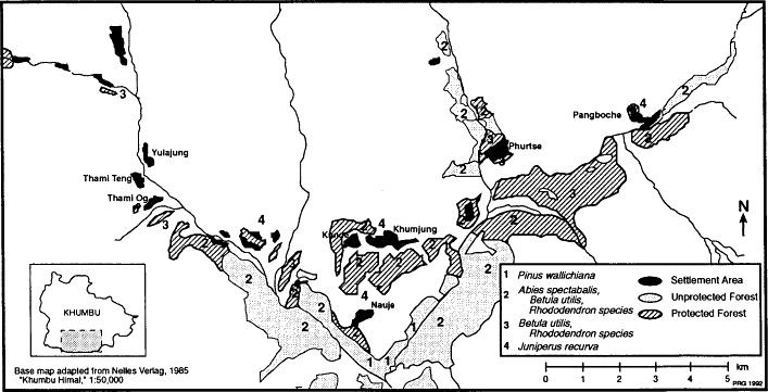
Map 12.
Khumbu Forests
Table 15 . Major Khumbu Tree Species | ||
Species | English Name | Sherpa Name |
Abies spectabalis | silver fir | tashing |
Pinus wallichiana | blue pine | metong |
Betula utilis | birch | takpa |
Rhododendron campanulatum | rhododendron | kalma |
Rhododendron arboreum | rhododendron | tongmar |
Juniperus recurva | juniper | shukpa |
Juniperus wallichiana | juniper | pom |
Salix sikkimensis | willow | changma |
between 3,000 and 4,200 meters. Fir and juniper may also be found in these temperate and subalpine forests. Just beyond the forest line, which here occurs at 3,800 to 4,000 meters, there is a thin zone, 50 meters in altitudinal range, in which shrub-high birch, rhododendron, and willow predominate (Byers 1987b).[3] Beyond this are scattered low-growing, alpine shrubs including juniper (Juniperus wallichiana , or Juniperus indica and Juniperus recurva , Sherpa pom ) and other alpine vegetation including dwarf rhododendron (Rhododendron setosum, nivale, lepidotum , and anthopogon ) which thrive to above 4,900 meters on north-facing slopes.
Forest distribution has been strongly affected by historical human use as well as by patterns of topography, precipitation, and altitude. The south- and west-facing slopes of the valleys, where the villages are, are mostly in open woodland, shrubland, and grassland rather than forests, and where forests are found they usually represent traditionally protected areas. Forests are most extensive where they are hardest to reach, separated from settlements by major rivers or situated on particularly steep slopes. The large forest areas in southern Khumbu on the west side of the Bhote Kosi river and on the south and east side of the Dudh Kosi and Imja Khola rivers are clearly shown in map 12. It appears likely that at one time, perhaps as recently as the early days of Sherpa settlement, forest cover was much more extensive in the region, and Sherpas report some changes in the extent, composition, and condition of forest during the past century. These changes are discussed in chapters 7 and 8.
The Khumbu dialect of Sherpa is not rich in forest terminology, but Khumbu Sherpas do discriminate between dense and open forest as well as differentiating forests on the basis of dominant species and describing the trees in them as notably large, small, old, or young. Forests are often referred to in terms of their dominant species (e.g. takpi nating and tashing nating for birch and fir forests). The Sherpa for dense forest is nating tukpu , "thick forest," while open woodland is nating shreme ,
"thin forest." Nating shreme refers to areas with quite open canopy and even to areas with very sparse tree cover. Nating tukpu generally refers to forest with a more closed canopy. Sherpas draw a distinction between the high juniper scrub (pom ) and forest (nating ). Local, common, and scientific names for major Khumbu tree species are given in table 15.
Forest Use
Forests are sources of fuel wood, food, timber, fodder, grazing, fertilizer, and material for many of the articles of daily life: wood for the local manufacture of furniture, tools, plows, saddles, kitchen utensils, containers, masts (gotar ) placed in front of each house to honor the birth of a son, house poles (chotar ) decorated with a prayer flag as an indication of religious faith, incense, and bamboo wands for mounting prayer flags on house roofs and high places.[4] Forests also provide a number of valued food and medicinal resources. These were formerly especially important to poorer families and during times of food shortage. Many families recall, for example, gathering the leaves of certain forest shrubs to use to make tea before the recent rise to affluence spurred by tourism, when they could not afford to buy the Chinese brick tea that was imported from Tibet for the well-to-do. Mushrooms are avidly collected in the forests today, as are wild herbs. The collection of forest leaves for fertilizer and the use of forests for fodder and grazing have already been discussed in earlier chapters. The use of local forests for sources of fuel and construction timber is treated in detail below.
It is worthy of emphasis that no timber has been exported from Khumbu within the remembered past, as it has in some other northern areas of Nepal that market lumber to Tibet. Some medicinal herbs were formerly collected and taken south even as far as India for sale. This no longer continues today. Formerly there was also some business locally in the making and selling of charcoal, which was manufactured by Khumbu non-Sherpa blacksmiths. Since the establishment of the national park charcoal making has almost entirely shifted to Pharak, where it is responsible for considerable use of oak.
Fuel Wood
Firewood (me shing ) is the main fuel used in Khumbu wherever it is easily obtained. Wood supplies energy for both cooking and heating, mostly for the former since most Sherpas make no attempt to heat their homes and rely for warmth even in mid-winter solely on small cooking fires, multiple layers of clothes, and drinking a great deal of hot tea.[5] Formerly the hearth consisted simply of an open fire over which was set
a stone tripod or an iron grate for cooking, but today this is seen only in herding huts. Main houses are virtually universally equipped with simple, stone woodstoves that have been adopted mostly during the past thirty years. Many families burn some dried dung in these stoves as well as using fuel wood. In Nauje, for example, it is common for a family to burn a third to half a load of dung per day (10-15kg), most of it dried yak or cattle dung (che ). Dung becomes still more important in the high country beyond the forests. Even in the highest huts, however, firewood is still used to some degree although Sherpas must travel several kilometers to gather shrub juniper.[6]
Birch is the preferred fuel wood, prized for its slow-burning qualities as compared with pine and fir, but what is burned in any particular hearth usually has more to do with what grows nearby than with preferences and birch makes up rather a small part of the woodpiles of most of the families of Khumbu.[7] Across Khumbu fir is probably the most commonly used wood, and much rhododendron, juniper, and even pine is also used in some areas. The shrub Cotoneaster microphyllus (Sherpa pemba koptok ) is considered a possible fuel and its roots are said to burn with a hot flame. The amount of labor required to dig it, however, makes it a fuel of last resort.[8]Masur , a shrub rhododendron, is burned as a fuel at high-altitude sites and, like juniper, is burned to release its fragrant smoke as an offering to the gods. It is not, however, as significant a source of fuel as juniper.
Household firewood use varies seasonally and also with wealth, household size and labor resources, and the accessibility of forests.[9] No studies have yet been done to measure household fuel-wood use and its regional and seasonal variation. A survey of Sherpa estimates of their wood use found that 77 percent of the Khumbu households surveyed reported their wood use to be about half a load of fuel wood per day.[10] The remaining 23 percent reported heavier use of one load per day. Village differences in reported fuel-wood use were significant, and higher use was reported in Kunde, Khumjung, and the Thamicho settlements than elsewhere (Sherpa 1979:19).[11] Nima Wangchu Sherpa and others have taken a half a load of wood a day per household as a reasonable regionwide estimate, which suggests wood use on a scale of 5,000 kilograms of fuel wood per household per year and a Khumbu-wide requirement of more than 3,000 metric tons per year.
It has been reported that Sherpas traditionally only burned dead wood (Bjønness 1983:270). This ascribes to them, however, a conservation practice they do not follow: As far back as villagers remember they have gathered dead wood when and where it was readily available and have obtained whatever else they required by lopping branches or felling trees.[12] Before the ban on felling trees for fuel wood that was imposed in
the late 1970s by Sagarmatha National Park administrators it was common to fell trees for fuel wood. Some Nauje Sherpas recall cutting ten to fifteen fir trees per year as recently as the mid-1970s. Usually trees were split into smaller pieces at the site and then allowed to dry before being hauled in baskets back to the settlement. Tree felling for fuel wood was traditionally permissible anywhere except within the boundaries of locally protected forests (kyak shing or "closed [for] wood"), where tree felling was allowed only for special purposes or banned altogether.
The distances villagers had to travel to reach unregulated forest varied. Residents of Nauje, Pangboche, and Phurtse could cut trees for fuel wood within a few minutes' walk of their houses. Nauje residents nostalgically recall being able to obtain three or more loads of fuel wood in a day since so little time needed to be spent in travel time to the cutting sites. Elsewhere, where forest was rarer or protected areas more extensive, the journey to and from cutting areas could require as much as several hours. Fuel wood was obtained from different areas during different eras, reflecting changes in the protected areas, the availability of dead wood, and the condition of forests outside the protected areas. The general pattern throughout the century has been toward longer journeys for fuel wood. Some areas reliable for fuel wood half-a-century ago or even thirty years ago ceased to be important sources before the 1970s. These included, for example, the slope south of Phurtse and above the Imja Khola, areas along the Imja Khola west of Pangboche, and pockets of forest along the slopes north of the Dudh Kosi river between Nauje and Kenzuma. Since the establishment of national park forest regulation the distance traveled for fuel wood has increased still further for some communities such as Nauje, Khumjung, and Kunde. Officially only dead wood can be gathered, and villagers are forced to seek out secluded areas far from national park patrols in order to obtain freshly cut wood to supplement the less-than-adequate supplies of dead wood available in the village vicinity.[13] Today residents of these three communities descend 500-700 meters to the Dudh Kosi river and climb a similar distance up the far slopes in order to reach areas where fuel wood can be safely obtained. Khumjung and Kunde villagers cross the Dudh Kosi and go high above Phunkitenga for fuel wood whereas the Nauje woodcutters cross the Dudh Kosi and climb up onto the slopes of Tamerku or cross the Bhote Kosi and climb an hour above the Satarma area. The trip to and from these sites requires a full day, and the arduous task of hauling a year's supply of fuel wood home in thirty to forty kilogram loads can require as much annual labor as farming potatoes does.[14] Across Khumbu men probably carry out most fuel-wood collection, but women do a great deal of this work as well and it is also a responsibility given to many teenagers.
Construction Timber
Sherpa houses require lumber for beams, floors, rafters, window framing, doors, and furniture. Fir shake roofs, moreover, are the most common regional roofing, even though slate is preferred whenever there is a quarry site within reasonable hauling distance and corrugated iron is increasingly being used in Nauje, Khumjung, and Kunde. Typical two-story houses today require eighteen cubic meters of timber, not including wood for furniture (Hardie et al. 1987:38). A relatively modest house requires fourteen trees for beams and joists, twenty to twenty-five trees for rafters depending on the type of roofing (larger, more closely spaced rafters being required to support slate roofs), plus several dozen more trees for boards for floors, window framing, doors, shelves and cabinets, and furniture. Recently new fashions of domestic architecture have begun to become popular which require even more timber for ceilings, paneling, and interior walls. Hardie et al. (ibid.7:39) estimate that this can increase the amount of timber needed for house construction by five to six cubic meters, or a full third.
All timber, including shakes for roofs, customarily was cut inside Khumbu. In some forests there were restrictions about what kinds of timber could be cut, but in others there were not. Certain areas were traditional sources of boards, rafters, shakes, and beams for particular communities. During the twentieth century Nauje families, for example, were accustomed to procuring beams from an otherwise-protected forest adjacent to the village, rafters and other timber from the forest immediately outside the restricted area, and shakes from forest half-a-day's walk away on the far slopes of the Dudh Kosi. The Nakdingog, Chuar, and Zamnangma Parken areas south of the Dudh Kosi (shown on map 18) have been renowned sources of timber and shakes for families from Khumjung, Kunde, Pangboche, and Phurtse since early in the century whereas beams were procured from closer at hand. Both Pangboche and Phurtse villagers were also accustomed to obtaining rafters and boards from the forest at the Tengboche monastery both before and after its establishment. Relatively little restriction was placed on this until the early 1960s when the head lama began to direct villagers to fell trees only in the Nakdingog part of monastery land.[15] It was usual to cut and saw timber at the site using simple hand tools, and there was some business in cutting and delivering lumber.
Demand for construction timber increased considerably in the twentieth century, placing new levels of demand on forests near villages. The major population growth since 1900 has meant that more structures have had to be built and rebuilt than in former eras. Khumjung, Phurtse, and Nauje have double or more the number of houses today than elderly
residents remember from their youths. Today's houses, moreover, bear little resemblance to those of sixty or seventy years ago which were nearly all one story. By the end of the 1980s increasing affluence had made single-story houses extremely rare throughout the region. Houses are increasing in size as well. There is a saying now in Khumbu that whereas once, when a Sherpa became rich, he spent his money on religion (thus accruing merit for his rebirth), he now builds a new house.
Historically forest use has been greatly affected by the availability of certain types of trees and by changes in local and national government regulations concerning tree felling. Changes in the types of trees used for beams, for example, suggest that the depletion of sizeable trees of certain types near some villages in the nineteenth and early twentieth century led to a switch from juniper to fir. In the late nineteenth and early twentieth centuries juniper for beams was available in the immediate vicinities of Phurtse, Nauje, Thami Og, Thami Teng, Khumjung, and Kunde. Now fir alone is used at all of these places due to the absence of large juniper. Indeed, today at Thami Og and Thami Teng there are no trees of any type that are suitable for beams, and villagers from these two communities now cut and haul fir from sites lower in the Bhote Kosi valley such as Samshing and Phurte as far as five kilometers away from their homes. Government regulation rather than local depletion, by contrast, has affected the use of fir for building material. Fir was long the preferred building material for most uses, but in the 1970s national park policies banned almost all tree felling for building and forced Khumbu Sherpas to import pine from Pharak. In 1990 a major policy change at Sagarmatha National Park returned some authority in forest management to Sherpa communities and relaxed some of its forest-use restrictions. Village committees and the national park are now allowing slightly higher levels of tree felling for construction purposes. Although more Khumbu fir is being felled today than in recent years most timber continues to be imported from Pharak.
Sherpa Protected Forests
No one knows exactly how local Khumbu traditions of forest management began. It is not clear whether or not Sherpas brought the concept of community forest management with them four centuries ago from Kham, borrowed the notion of protected forests from sacred groves they may have heard about or seen during their migration across Tibet to Nepal or from their new neighbors in the Dudh Kosi region, or invented the idea themselves in Khumbu. There are oral traditions, however, that some forests were regarded as sacred and put off limits from tree felling very early in the Sherpa settlement of Khumbu. Other forests were
protected for religious reasons during succeeding centuries. Only in the relatively recent past, in the early twentieth century, however, did Sherpas begin to establish other kinds of forest preserves as well. It was the management of one of these recently protected secular forests, the forest adjacent to the villages of Khumjung and Kunde, that Fürer-Haimen-dorf (1964:110-113, 1975:97-98) described as an example of the traditional Khumbu Sherpa system of village forest regulation. This forest, however, had not been protected since time immemorial but rather for less than fifty years, and represented not a typical village-managed forest but only one of several types of Khumbu protected forest. Khumbu sacred groves and other types of protected forests went unreported in the anthropological literature.
Through time a rich diversity of forest-management systems was developed in Khumbu. Particular forest areas belonged to or were administered by villages, monasteries, temples, and pembu. There eventually came to be at least seven types of communally protected forests, encompassing nearly half of Khumbu's twentieth-century forest cover (map 13).[16] More than twenty separate forest areas were regulated. These forests were set aside at different times for different purposes and administered according to different rules. The Sherpa term kyak shing encompassed not only forests protected so carefully that no sharp instrument could be taken into the area but also forests in which trees could be felled for house beams. Some protected forests were administered so as to keep villagers safe from divine wrath or evil fortune, others simply ensured that families would continue to have a source of certain forest resources conveniently close by. They had in common the fact that in all of them there were at least some restrictions on the purposes for which trees could be felled. In all other Khumbu forests no such rules applied.
Sacred Groves
Sacred trees and forests are an integral part of the landscape of Khumbu, an expression of the historical depth of Sherpa Buddhist faith.[17] Villages and fields are dotted with trees believed to be the homes of lu, spirits worshiped by particular families who pass down the caretaking of the tree, spirit, and shrine through generations. Temples are surrounded by sacred groves. Other forests, called lami nating (lama's forest) are set apart because certain lamas sanctified them as places where no tree must be cut and into which no cutting implement might be taken. These sacred forests and groves were the earliest, most strictly regulated, and most enduring of the protected forests. They encompassed substantial areas of trees in what were often prime sites for harvesting timber and fuel wood adjacent to villages.
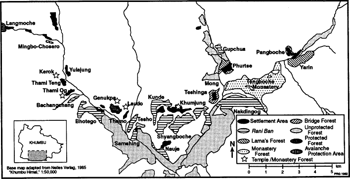
Map 13.
Khumbu Protected Forests
Sherpa sacred forests may have evolved from Sherpa and Tibetan beliefs about the spirits known as lu. Sherpas believe that several types of these half-human, half-serpent, female spirits live in Khumbu, inhabiting springs, boulders, trees, shrines, and houses.[18] The lu of springs control the flow of water and can, if offended, withhold it.[19] Boulders can be inhabited by a male saptok , similar to a lu. These beings have an evil reputation for causing harm to people who pass near them and are much feared by travelers caught between villages by nightfall. Most houses have a lu and a special shrine (lu khang or "lu's house") is built inside the home for it. These are usually small, stone shrines tucked in unfrequented corners of the house, usually in a lower-story corner. These lu can influence family health and luck for good or ill and hence must be very carefully respected and given regular offerings. Tree lu sometimes live in trees near springs and sometimes in the forests. It is said that these forest spirits sometimes follow people home and take up residence in trees near their house. Lu trees within villages are a distinctive phenomenon. These may be few or many and can be of any species. Each belongs to one of the families whose house is nearby and the women of that family have responsibility for carrying out rites at it.[20] Often a small shrine is built at the foot of the tree.
Beliefs in lu are widely shared by many different Sherpa groups in northeast Nepal. Individual lu-inhabited trees and small groves can be seen in Pharak, Shorung (where there is an especially fine grove at Junbesi), and in the upper Arun valley.[21] Khumbu, however, seems to be particularly densely populated by lu, for nowhere else in the Sherpa world are lu-inhabited trees so common. These are the trees, usually old juniper (Juniperus recurva ), but occasionally rhododendron, willow, or fir which so distinctively dot Khumbu villages and fields. Often they are virtually the only trees left standing in the settlement. Many have shrines at their base, but even when lu trees are not marked by shrines they are still trees that are well-known to all villagers and which they treat carefully. To offend a lu is considered dangerous, for serious illness and other family misfortune can follow.[22]
The beliefs and bans surrounding what is reputedly the earliest sacred forest, the grove at Pangboche, greatly resemble those associated with lu-inhabited trees. It is believed that to cut trees in the grove brings bad luck and illness. These juniper trees near the Pangboche temple are said, in fact, to be inhabited by lu as well as to be sacred because they were created four centuries ago by the great early Sherpa religious hero, Lama Sanga Dorje, who here scattered a handful of hair to the wind which, on failing back to earth, took root as forest. To cut these trees even with the best of intentions is dangerous. Pangboche villagers still talk, for instance, about a famous carpenter called in from Nauje to
direct a temple-restoration project half a century ago, who requested that junipers near the temple be cut to provide building material. This was done, although very reluctantly due to fear of offending the lu. According to villagers the spirits were indeed angered and this resulted in the carpenter's death only three years later.
Lami Nating: "Lama's Forests"
The largest sacred forests in Khumbu are those that were established by the personal intervention of revered local religious leaders. There are several examples of such lama's forests including those in the vicinity of Yarin, Phurtse, Mong, Mende, Thami Teng and Mingbo-Chosero (map 13). The Yarin forest, said to have been declared kyak shing by Lama Sanga Dorje, is the largest of these lama's forests, extending more than a kilometer along the upper Imja Khola. The smallest, a tiny grove near Mingbo, was protected only in the late nineteenth century by Lama Zamde Kusho, who then had a hermitage in the area.
The most famous of the lama's forests among the Sherpas is at Phurtse where all remaining forest within an area bound on the south by Thakso ridge, the east by the trail still called "the lama's trail," the north by Luriphungga creek, and the west by the Dudh Kosi was declared protected forest by a lama well over a century ago. According to the legend a lama who lived in a hermitage just above the village warned villagers during an especially powerful ceremony that grave misfortune would attend the family of anyone who took any sharp instrument into the forest, be it an axe, a kukri (the Nepali machete), or a knife. This prohibition apparently also originally included the forest on the other side of the Dudh Kosi below Mong. Much of the Phurtse lama's forest has been very stringently protected, and here at 3,800 meters there are more than ten hectares of birch, some probably a century-and-a-half old, whose gnarled and mossy limbs show no sign of ever having been lopped. The island of protected trees south of the village, however, has not fared so well (see table 16) and neither has Mong. Control of the Mong area was disputed between Phurtse and Khumjung. After a series of rulings early in this century by local pembu and distant Nepali courts the villagers of Khumjung gained rights to the area. Phurtse residents claim that Khumjung people began cutting trees in the Mong forest despite the beliefs attached to it by people from Phurtse. Illness, they also say, and years of very heavy snowfall followed. In 1990 Phurtse villagers, led by young people, agreed to allow dead-wood collecting in the Phurtse lama's forest. This is the first time that this has been permitted in living memory. But the community continues to ban tree felling in that forest. Today, as for a century or more, two villagers each year
Table 16 . Khumbu Sacred Forests | ||
Lama's Forests | ||
Name | Location | Period Protected |
Pangboche | Pangboche | 400 years |
Yarin | near Pangboche | 400 years |
Phurtse | Phurtse | more than 100 years |
Mong | west of Dudh Kosi | more than 100 years |
Mingbo-Chosero | Langmoche Chu | 100 years |
Khumbu Temple Groves | ||
Name | Location | Approximate Age of Temple |
Khumjung | Khumjung | 150 years |
Thami | Thami Og | 400 years |
Kerok | Kerok | 400 years |
Genukpa (tsamkhang) | Above Thami Og | 100 years |
continue to act as shinggi nawa, ensuring that the local regulations are followed.
Temple and Monastery Groves
Trees growing around temples are respected, and small groves are associated with the temples of Khumjung and Kerok and several small monasteries and nunneries, most notably at Thami Og and at Tengboche.[23] Temple and monastery groves (with the exception of Tengboche, discussed below) are much smaller than lama's forests. The largest, Kerok, encompasses little more than a hectare of old birch and rhododendron. There is a conspicuous lack of oral traditions regarding these groves, suggesting that these trees acquired sanctity from the founding of the temple rather than the existence of already-sacred groves having been the reason for the building of religious structures at those sites. Temple groves in Khumbu, unlike those in some other Sherpa areas, have not been planted within memory. It thus seems possible that some temple groves are relics of presumably once-more-extensive forests or woodlands. Felling trees in temple groves is regarded as an inauspicious act, and no special forest guards are considered necessary. Few trees in such groves show signs of having had limbs lopped.
Tengboche monastery, founded in 1919, controls an extensive forest area that is often assumed by Western visitors to be sacred forest. This forest, however, is not venerated as a result of its association with legend-
ary or historical acts of gods, spirits, or lamas. It is rather the largest privately owned forest in Khumbu and has been ever since the area was granted to Lama Gulu by the eight Khumbu pembu in 1919.[24] The monastery allowed tree felling in its forests before Lama Gulu's death in 1934, and during the administration of those who managed the monastery during the youth of his incarnate successor (1934-1957). Phurtse families recount that there were no objections to their felling trees on its land for house rafters and boards. The present, stricter regulations on logging date to the period after the current head lama returned from training in Tibet in 1957. Tree felling on the Nakdingog side of monastery lands, however, continued to be authorized until quite recently.
Secular Preserves
According to oral traditions the only protected forests in Khumbu before the early twentieth century were sacred forests (with the possible exception of one area of Phurtse which is discussed below). During the past eighty years, however, a number of protected forests were established which had no religious basis and were administered by local officials or community assemblies. Unlike the strictly protected sacred groves and forests these secularly managed preserves allowed limited logging for special purposes. In some of these forests trees could only be cut for beams for housebuilding. Other protected forests supplied timber for important bridges. In one case the cutting of shrub juniper was forbidden in order to guard against avalanche danger.
Rani Bans
The most significant of these new, secular preserves in terms of both numbers and area were the rani ban . Between 1912 and 1915 eight of these protected forests were designated in Khumbu protecting substantial areas in the vicinities of the villages of Nauje, Khumjung, Kunde, and Thami Og, the Bhote Kosi valley gunsa of Thamo, Phurte, Samshing, and Pare, and the upper Dudh Kosi herding settlement of Konar. Management aims, regulations, and enforcement varied considerably among these forests, but in all of them unauthorized logging was prohibited by the eight pembu under authority vested in them by the Rana government in Kathmandu.
Until the early twentieth century the pembu had nothing to do with forests. This changed when prime minister Chandra Shamshere Janga Rana's Kathmandu government ordered village headmen and other local leaders including the pembu of Khumbu and Shorung to each take
Table 17 . Khumbu Rani Ban | ||
Name | Responsible Pembu | Location of Forest |
Nauje | Murmi Yulha | Nauje |
Gupchua | Mun Puri | upper Dudh Kosi valley |
Nakdingog[*] | Gyaliwa | valley of Phunki Chu |
Samshing | Gardza | Bhote Kosi valley |
Tesho | Karta | valley of Tesho Chu |
Bachangchang | Yulha Tarkia | Thami Og |
Khumjung-Kunde | Yuli Putar | Khumjung-Kunde |
Bhotego | Thamo Mum Dorje | Pare |
* Part of this area was transferred to the control of the Tengboche monastery at the time of its establishment. | ||
responsibility for the administration and protection of a forest in which all hunting would be prohibited.[25] Each leader was instructed to select an area, state its boundaries, and send the information to Kathmandu. About two years later, in Solu-Khumbu beginning as early as 1911-1912, each received a document that set down his name, the boundaries of the forest over which he had jurisdiction, and the rules to be enforced there.[26] These regulations strictly limited logging. Villagers were required to get permission from the responsible pembu or other local government official for felling in these forests. Tree felling for special uses, such as building a bridge, could be agreed on by the pembu and his villagers. Other special requests, including house timber, were supposed to be passed on to a district office (gosara ) in Olkadunga, an administrative center several days' walk south of Shorung and a week from Khumbu. Offenders were also to be reported to officials in Olkadunga, who would rule on their cases and administer fines. These forests became widely called rani ban in Solu-Khumbu and other regions.
Pembu throughout what is now the Solu-Khumbu district chose forests and implemented regulations for their use. In Shorung some pembu selected vast areas of forest, far larger than any of the regulated Khumbu forests. These, however, were situated in areas remote from villages and were not important sources of local fuel wood and timber. In Khumbu something else altogether took place. Khumbu Sherpa pembu creatively interpreted the Rana rules to create institutions that were different from those envisioned by Kathmandu officials, but were more useful in the environmental and social context of Khumbu. They developed their own forest regulations and their own ways of enforcing them. Unlike their counterparts in Shorung they for the most part chose
responsibility for forests that were close to settlements and were then important sources of fuel wood and timber.
In all Khumbu rani ban some subsistence activities were allowed. There were no restrictions on gathering dead wood, collecting soluk for fertilizer, lopping for fodder or fuel, or grazing. Logging was totally banned in only one rani ban, Bachangchang, a forest that already had long been protected as a lama's forest. Elsewhere trees in rani ban could be felled, but only for specified purposes. In most rani ban tree felling was allowed only for obtaining beams for house building and then only with the authorization of the responsible pembu—or in the case of the Khumjung and Kunde rani ban, with the approval of the community-designated forest guardians.[27] The rani ban were thus the first Khumbu forests in which tree felling was regulated in any other way than by simply being banned, and the first forests in which felling was restricted to particular sizes of trees for specific purposes.
Enforcement of these regulations was handled differently than the Rana officials had envisioned. Offenders were not sent to Olkadunga. Appropriate fines were determined locally by pembu or village meetings and were locally levied. For the Khumjung-Kunde and Bhotego rani ban community management institutions were established which had precedents in the guardians traditionally chosen for the Phurtse lama's forests. These were the shinggi nawa made famous by Fürer-Haimendorf's depiction (1964:110) of them as forest guards chosen by every Khumbu village. Only three of the eight villages actually selected shinggi nawa and such officials administered only a quarter of Khumbu's rani ban and only a seventh of all the region's protected forests.
Some Sherpas consider that the establishment and form of the Khumbu rani ban were a response to forest change and particularly to the increasing scarcity of certain types of forest resources in particular areas. In some parts of the region there was a growing concern in the early twentieth century with the increasing scarcity of large trees in locations convenient for the provision of beams. By 1900 the preferred junipers used for house beams had been depleted in the vicinity of all the main villages and within a few more decades none could be found anywhere in Khumbu—the only remaining trees of sufficient size having long since been recognized as sacred, lu-inhabited trees. Fir became the main timber for beams, but even this was scarce in some areas. Some Sherpas interpret the declaration of rani ban adjacent to Khumjung, Kunde, and Nauje and in the lower Bhote Kosi valley as a measure to protect the supply of beams close to those communities, and the protection of the rani ban at Bachangchang as an attempt to preserve critical supplies of soluk. Doing so required creative, local interpretation of the forest-protection rules issued in Kathmandu, which made no provision
for such a degree of household forest use or for administering forests with locally elected officials.
Khumbu Sherpas demonstrated considerable ingenuity in tailoring a national institution to local environmental and social conditions, and the Khumbu rani ban clearly illustrate a greater concern with protection of scarce resources than do the rani ban declared at the same time in Shorung.[28] It is worth noting, however, that only half of the eight Khumbu villages had a village system of forest management that regulated subsistence use of adjacent forest. Thami Teng and Yulajung had no protected forest of any type. Pangboche and Phurtse had only adjacent sacred forests, and Thami Og a former sacred forest that was similarly protected after being designated a rani ban. The range of forest uses that were regulated by the rani ban was also somewhat narrow, a characteristic that has had important ramifications for twentieth-century forest-use patterns and regional forest change.
Since the early twentieth century local management of most of the rani ban has eroded. The forests at Nakdingog, Samshing, Tesho, and Gupchua ceased to be well protected before the 1950s and guardians for them may not have been chosen or appointed after the deaths of the pembu who took original responsibility for them, if indeed their protection lasted that long. Tesho may have been protected somewhat longer by local customs even if these may have ceased to have institutional enforcement. The Nauje and Khumjung-Kunde rani ban ceased to be protected in the late 1960s after forest nationalization and the shinggi nawa administration of the Bhotego rani ban was abandoned in the late 1970s following establishment of Sagarmatha National Park. Local management, however, began to revive in the late 1970s in the Khumjung-Kunde rani ban.
Bridge Forests
At least two forests were protected in order to ensure that a continuing supply of bridge timber would be available. Until the 1960s when cable suspension bridges were first built in the region, Khumbu bridges often had short life spans. Most were cantilever, timber spans that extended only a few feet above the water. Rivers in monsoon spate or swollen by floods caused by the sudden emptying of glacial lakes by avalanches or the collapse of retaining moraines claimed many bridges, and some bridges that obviously had little chance of surviving the flood season used to be taken down each spring and reconstructed in the autumn. Phurtse was probably the first place where an area of forest was protected specifically to provide bridge beams. Here logging was allowed in one corner of the lama's forest for timber to maintain the bridge
across the Dudh Kosi. This custom may predate the beginning of the century, and if so would be the first example of forest management in Khumbu for non-religious reasons. The bridge forest at Teshinga was protected after the establishment of the Tengboche monastery at the request of Lama Gulu who wanted to ensure an adequate supply of beams to keep the bridge over the Dudh Kosi near Phunkitenga in repair. This bridge was the main link between the monastery and western Khumbu. Later the area became administered as part of the Khumjung-Kunde rani ban.
Avalanche Protection
Protected forests in Khumbu were normally not set aside with the aim of guarding villages against avalanches as has sometimes been assumed (McNeely 1985). Forest above villages was instead generally the first cut, since avalanches have apparently not been considered to be a risk and carrying beams and timber downhill to house sites was enticingly easy. Protected forests tended to be located on the downhill or lateral margins of settlements. In one case, however, an area of high-altitude scrub juniper was deliberately protected as a defense against avalanches.[29] During the 1940s the seasonal herding settlement of Lang-moche (on a tributary of the Bhote Kosi in northwestern Khumbu) was twice struck by avalanches. The second time two houses were destroyed. After that disaster residents decided that from then on no juniper (Juni-perus wallichiana ) shrub should be cut anywhere on the slopes overlooking the village on either side of the stream. A shinggi nawa system was set up in the late 1940s to enforce the regulation and was still operating in 1985. This was the only area of high, alpine shrub juniper in Khumbu which was administered as kyak shing prior to the recent protection of juniper around the monastery of Laudo (near Mende above the lower Bhote Kosi).
Administering and Enforcing orest Regulations
Fürer-Haimendorf described one system of administering and policing protected forests, the shinggi nawa forest-guard system. According to his account this was characterized by annual selection of several villagers to act as forest guardians. Officials were chosen by a small group of powerful villagers and could be reelected for an indefinite number of years in succession. Shinggi nawa were granted the power to
levy fines on violators. The amount of these fines was socially approved and the penalties were administered publicly at a once-a-year gathering during which the fines (paid in beer) were consumed amidst an assembly of villagers who listened to the confessions of the accused Fürer-Haimendorf 1979:110-113).[30]
Elsewhere in Khumbu the shinggi nawa institution, however, was not identical to that described by Fürer-Haimendorf. In Phurtse shinggi nawa were selected for overseeing the lama's forest by a village assembly rather than in a small group meeting. This was also done in Pare for the Bhotego rani ban. At Pare, and formerly also in Phurtse, the office rotated among households and was not customarily held for more than a year.[31] The rules that shinggi nawa enforced were formulated for some forests by pembu or lamas rather than by villagers. The number of guardians was not standardized and varied from two to four. Still more surprisingly, the responsibilities and powers of the shinggi nawa, even in Khumjung and Kunde, seem to have been exaggerated in the literature. They did not patrol forests, select trees to be cut, or ordinarily inspect wood stocks for overcutting. Instead they were solely concerned with fining those people who were discovered felling trees in protected areas. These fines were slight, often paid only in beer, and the enforcement of the regulations depended largely on social pressure. In most cases, other than in Khumjung and Kunde however, there was no ceremony at which villagers were publicly humiliated and fined before the assembled community. Instead nawa paid a visit to offending families at their homes to collect cash fines and to consume fines paid in beer in lieu of or in addition to cash fines. Community meetings, or at least meetings of a large number of villagers, were held only to select nawa for the coming year (Nauje, Pangboche) and sometimes to review the regulations they would enforce.
The shinggi nawa system was not the only way in which protected forests or even rani ban were managed in Khumbu. Nawa rather than shinggi nawa were in charge of administering forest regulations in the Pangboche and Nauje areas. In both cases these officials were given forest-watching duties in addition to their usual responsibilities of enforcing seasonal grazing closures and blight defense regulations.[32] At Nauje, however, permission to cut trees in the rani ban adjacent to the village had to be obtained from the pembu responsible for that forest rather than from the nawa. For the Samshing forest the responsible pembu gave the task of enforcing the forest rules to one of his household servants. Some pembu kept full responsibility themselves for the protection of the rani ban. Table 18 identifies the management systems formerly in use in the various Khumbu protected forests. Table 19 categorizes these local administrative arrangements into seven systems.
Table 18 . Khumbu Protected Forests (Pre-1965 Administration ) | ||
Forest | Administration | |
Lama's forests: | ||
Phurtse | Shinggi nawa | |
Yarin | Nawa | |
Mingbo-Chosero | None prior to 1984 | |
Pangboche | Temple watcher | |
Temple forests: | ||
Kerok | Lama | |
Khumjung | Lama | |
Laudo | Lama | |
Private forests: | ||
Tengboche | Lama and council of monks | |
Thami | Private households | |
Rani ban: | ||
Khumjung-Kunde | Shinggi nawa | |
Nauje | Pembu and nawa | |
Bachangchang | Gembu/pembu | |
Tesho | Pembu (lapsed) | |
Samshing | Pembu (lapsed) | |
Nakdingog | Pembu (lapsed) | |
Gupchua | Pembu (lapsed) | |
Bhotego | Shinggi nawa | |
Bridge forests: | ||
Phurtse | Shinggi nawa | |
Teshinga | Shinggi nawa (Khumjung) | |
Avalanche protection: | ||
Langmoche | Shinggi nawa | |
Uncertain status: | ||
Thamo | Shinggi nawa (lapsed) | |
Traditional Forest Management Systems Re-examined
Instead of the single "village forest" management system so often described for the Khumbu region there were thus a number of diverse forms of forest management. Sherpas developed an extraordinary number of these systems and protected an unusually large percentage of local forest and woodland through them, including a significant area of forest
Table 19 . Forest Admistration Systems | |||
Systems: | |||
1. Village management with shinggi nawa (elected, multiple terms possible) | |||
2. Village management with shinggi nawa (rotated) | |||
3. Village management with nawa (rotated) | |||
4. Pembu appointment of shinggi nawa, nawa, or guards | |||
5. Pembu direct regulation of forest use | |||
6. Temple management | |||
7. Private forest (group management) | |||
System 1. | |||
Lama's forests: | Phurtse | ||
Mingbo-Chosero | |||
Rani ban: | Khumjung-Kunde | ||
System 2. | |||
Lama's forests: | Phurtse (formerly) | ||
Rani ban: | Bhotego | ||
Other: | Langmoche | ||
System 3. | |||
Lama's forests: | Yarin | ||
Rani ban: | Nauje[*] | ||
System 4. | |||
Rani ban: | Samshing | ||
Kunde? | |||
System 5. | |||
Rani ban: | Bachangchang | ||
Gupchua? | |||
Tesho? | |||
Nauje (with nawa enforcement) | |||
System 6. | |||
Lama's forests: | Pangboche juniper | ||
Yarin | |||
Temple forests: | Kerok | ||
Thami Og | |||
Mende | |||
Khumjung | |||
System 7. | |||
Private forest | Tengboche (council of monks) | ||
* Formerly pembu granted permission to fell trees in the Nauje rani ban. Nawa, however, were solely responsible for enforcing the summer bans on the import of freshly cut wood, which protected the village from the risk of blight. | |||
that was a continuing source of subsistence forest products. This is unusual in my experience of other areas of northeastern Nepal. Although sacred forests are common in much of Nepal and rani ban were established in many areas, it seems rare to protect such a relatively high proportion of local forestland. None of the other Sherpa regions with which I am familiar have anything resembling the diversity or extent of Khumbu forest protection. In some of these there are protected forests, including temple forests in the Salpa pass area, Katanga, and Helambu, lu forests in Shorung and the Arun region, and rani ban in Shorung, Gora, Golila-Gepchua, and Olkadunga. But these are, with the exception of a few of the rani ban, all quite small scale, and the rani ban other than those in Khumbu were often established in remote areas where the regulation of subsistence use was not a critical social or environmental concern. Khumbu Sherpas have thus achieved something rather special for Sherpas and very probably extraordinary in the context of Nepalese forest management more generally.
Each of the seven Khumbu systems of forest management has its own goals, rules, and institutional arrangements. None corresponds directly with the "village forest" previously presumed to have been the characteristic form of local forest management in the region. Contrary to what has been assumed most Khumbu protected forests have not been protected since time immemorial. Of the seven types of protected forest only two, the lama's forests and temple forests, were definitely protected before 1900, and only one bridge forest may date to that period. The gradual development of different types of protected forests at different times resulted in a regionally uneven pattern of management. Some villages had adjacent regulated forests, others did not. The state of forest cover that existed in the early twentieth century influenced which regions could be designated rani ban, and past patterns of forest use and degradation meant that not all villages had adjacent forests left to protect. And no Khumbu forest-management system administered any "village forest" in the sense of a commons in which residents obtained all of the forest products necessary to their subsistence in a regulated way. Sherpa protected forests were not intended to regulate the entire spectrum of any community's forest use, nor to be the sole or even primary source of any settlement's forest resources. Throughout the period before the establishment of Sagarmatha National Park there was other forest close at hand to exploit which was not regulated at all, and this was where use was concentrated. The significance of this selectively protective, traditional resource management for historical environmental change will be taken up in chapter 7.