The Physical Enviroment
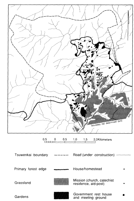
The government rest house of Tsuwenkai lies at about 5º25' S, 144º38' E, at an altitude of 1,680 meters. The settlement is in the headwaters of the Pint River, a tributary of the Jimi. The Jimi Valley comprises the Tabibuga District of the Western Highlands Province and is administered from Tabibuga on the Tsau-Jimi Divide. Until the early 1970s, when a road suitable for four-wheel drive vehicles was completed from Tabibuga to Banz in the Wahgi Valley, the only means of contact within and beyond the Jimi was by walking tracks or light aircraft. By the mid-1980s the Kundagai and others had invested around twenty years' of manual labor into building a road connecting settlements on the north bank of the Jimi to Tabibuga. Although the Jimi River was bridged in 1978, the road was still not passable in 1985 to traffic beyond a few kilometers from the bridgehead. Long, well-graded, but unconnected sections of road were continually reclaimed by secondary growth or swept away in landslides. The labor involved in roadbuilding and maintenance was compounded by repeated rerouting of extensive sections of the road.
The north wall of the Jimi Valley is formed by a western extension of the Bismarck Range. The valley is separated from the densely populated Wahgi Valley to the south by the Sepik-Wahgi Divide that rises to over 3,700 meters in places. These two ranges converge in jagged, cloud-piled ridges on the central massif of Mount Wilhelm. On clear days this highest peak in Papua New Guinea is visible from Tsuwenkai some 60 kilometers to the southeast, rendered a mere hummock by the
Map 2.
Tsuwenkai Vegetation and Settlement
closer, more dramatic ranges. The Jimi is a turbulent, rock-strewn river that rises on the snow-fed slopes of Mount Wilhelm and plunges down its narrow, cliff-hung bed on its way to the Sepik River to the northwest. To the north of the Bismarck Range the Simbai River flows eastward and then north to join the Ramu River.
I made no detailed records of climate during fieldwork other than noting temperatures for 204 days over 12 months in 1973-1974. Clarke (1971: 39-50) and Rappaport (1968: 32-33) give details of rainfall at Gunts, Tsembaga, and Simbai Patrol Post in the Simbai, and at Tabibuga in the Jimi. On comparative grounds the annual rainfall at Tsuwenkai is probably between 3,000 and 4,000 millimeters.
During the wetter season, about November to April, rain falls almost every afternoon, and mountain peaks are often obscured by cloud for much of the day. In the late afternoon heavy banks of cloud well up in the Simbai to spill over into the Jimi, and the evening is often enlivened by the ominous roll of distant thunder and the flicker of lightning from the Ramu lowlands. The dank and miserable reputation those regions enjoyed among my Kundagai friends seemed well deserved.
In the drier season, May to October, the sky is often cloudless and no rain may fall for periods of up to a week. Occasionally the dry season does not become properly established, or is shorter than usual, and so hampers garden preparations as gardeners wait for fine weather. Under these circumstances a gardener may be unable to clear as much land as desired or to achieve an adequate burn of trash. Such times create anxiety over food shortages, although the Kundagai mainly suffer hunger for favored crops rather than any serious absolute shortage of food. Heavy afternoon rains sometimes cause minor flooding of streams, small landslides beside tracks, some sheet erosion in gardens with sparse vegetation cover, and damage to sugar crops flattened in the downpour. Although excessive rain periodically causes problems, the Jimi does not appear to be significantly affected by drought, although many smaller streams dry up toward the end of the drier season.
Daily maximum temperatures varied during fieldwork from 16.5º C in June to 29º C in October, averaging 22.8º C. Minima were usually reached around six A.M. and ranged from 11º C to 18º C (both records in November), averaging 14.9º C. I do not know if frosts ever occur; certainly the Jimi was not affected by the devastating frosts in higher
altitudes of the Western and Southern Highlands Provinces of 1972, which occurred while I was in the upper Jimi.
As elsewhere on the highland fringes the landscape is dramatic. The Jimi River flows along the northern part of the valley so that a cross-section of the valley is a lop-sided V shape, with a steep north wall and more gentle southern slopes. Especially on the north side the numerous watercourses are deeply incised, producing a rugged topography. Tsuwenkai itself is situated on the flanks of a range on the west of the Kant River, extending southward from the Bismarck crest. The Kant Valley is narrow, with short, steep lateral spurs and intervening streams. The Kant joins the Pint River south of Tsuwenkai. Aside from some tiny marshy patches by the river, there is no flat land in the Kant Valley and only a few gently sloping areas along the upper course of the Pint. Tsuwenkai territory ranges in altitude from about 1,200 meters to at least 2,800 meters in the short space of about six kilometers.
North of Tsuwenkai a low pass, Gendupa, allows fairly easy access across the Bismarcks to the Simbai Valley. A similar pass at Gachambo at the headwaters of the Kant connects with the Mieng drainage system. Another pass north of the Mieng gives access to Kumbruf in the Simbai.
The loose shales and clays of the Tsuwenkai region are prone to landslides, especially after the shallow soils are waterlogged with rain. Small slides are common on embankments beside tracks and gardens. Larger slides of one or more hectares in extent occur in both grasslands and primary forest.