The First Phase: The 1930s
The first cité indigène by François Bienvenu was an HLM that consisted of sixty-two apartments. Located on the Boulevard de Verdun, which defines the northern boundary of the casbah, it sits on

Figure 58.
Schematic plan of Algiers showing the location of housing projects discussed in this chapter. The numbers correspond
to the order in which the projects appear in the text. (1) Boulevard de Verdun, (2) Scala, Clos Salembier, (3) Ste.-Corinne, (4)
Climat de France, (5) Boucle-Perez, (6) Diar el-Mahçoul, (7) La Montagne, (8) Dessoliers, (9) Carrière Jaubert, (10) Djenan
el-Hasan, (11) Cyclamens, (12) Nador, (13) Eucalyptus, (14) Taine E, (15) Asphodèles, (16) Mahieddine, (17) Dunes, (18) Diar es-Shems.

Figure 59.
(above) François Bienvenu, cité indigène project, Climat de France, 1933. Figure 60.
(below) Louis Bérthy, cité indigène project, 1936.
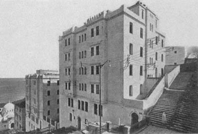
Figure 61.
Bienvenu, Boulevard de Verdun housing, view, 1935.
the ramparts of the Ottoman fortifications (Fig. 61). Its placement at the very edge of the old city and its architectural qualities—"rationalized" from the houses of the casbah—allude to its symbolic ambivalence: the Verdun housing belongs and does not belong to the casbah. The cité consists of three blocks, separated from each other by interior passageways and courts. Multiple entrances, marked with horseshoe arches, provide access to various levels, but only from the Boulevard de Verdun side; the complex cannot be reached from the casbah. The massing and the height of the blocks (which reach seven stories at their highest) form a contrast to the scale and fabric of the casbah and further accentuate the "in between" quality of the project. The complex topography of the site helps enliven the volumes and spaces; while the facades on the Boulevard de Verdun are from six to seven stories high, the back facades remain only three stories.
The architecture of the Boulevard de Verdun blocks aimed for a new urban image that combined the "traditional" with the European and a new housing type that responded to the customs of Muslim residents while giving them the amenities of modern habitation. With their clean, modernist lines, white surfaces, sparse openings, crenellated rooflines, and flat roofs, the new buildings complemented the old quarter in their picturesque appearance, but their exaggerated height on the Boulevard de Verdun acted as a clear-cut boundary. The plans were derived from
the courtyard houses of the casbah, but what was private in the latter was made public in the former: apartment units now faced the courtyard, not the rooms of the same house. A continuous hallway surrounded the courtyard and gave access to individual units. The concept remained a simple enlargement of the casbah-style house into a communal type, despite the emphasis on "conform[ity] to Muslim customs."[3]
As it was the first housing project built for Algerians in a prominent location, the Boulevard de Verdun apartment complex enjoyed great publicity. Yet it failed to serve as a model for other complexes in the 1930s, because the predominant characteristics of the "traditional" Algerian house (as studied by the French) dictated that "horizontal" housing met the needs of Algerians better than "vertical" schemes. The choice for low-rise single-family patterns called for ample space, and the subsequent low-cost projects were not built in the center of Algiers, where land was scarce and expensive.[4] The Boulevard de Verdun housing thus remained a unique experiment.
In contrast to the Boulevard de Verdun blocks, the other two schemes realized in the 1930s were horizontal developments located away from the center of Algiers and consisted of attached individual units, each with its own courtyard or small garden behind high walls. Architects Albert Seiller and Marcel Lathuillière designed the Cité Scala (also known as La Madania), on the Clos Salembier hill, near Belcourt. Covering an area of 8 hectares, this settlement was intended to house six thousand residents with diverse social origins, including "the poorest . . . families and bachelors who had just arrived from the countryside." The project was considered an excellent social and political solution to the pressing problem of hygiene, commonly attributed to old indigenous quarters of the city.[5]
Lathuillière's sketch, published in Chantiers in 1935, shows a compact settlement nestled against the hill and consisting of cubical, flat-roofed, low-rise houses with very small windows (Fig. 62). The rooflines of the houses are broken by chimneys and, on the larger scale, the domes and minarets of the religious and social centers animate the entire built fabric. A central axis divides the quarter in two and is stepped to conform to the topography. On this axis is a public square faced by a large institutional building with neo-Arabic facades and a courtyard. Lathuillière's idealized drawing borrows from the picturesque Islamic villages of the world's fairs, especially from the 1931 Colonial Exposition with its extensive Tunisian village and from Morocco's nouvelles médinas of the 1910s and 1920s. Nevertheless, it also displays a similarity to Tony Garnier's
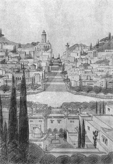
Figure 62.
Albert Seiller and Marcel Lathuillière, housing project in Clos Salembier, initial scheme, 1935.

Figure 63.
Seiller and Lathuillière, housing project in Clos Salembier, site plan, 1936.
Cité Industrielle in the cubical white masses of the housing, the courtyards, the placement of communal facilities, and the clear hierarchy between main streets and residential ones. If the "arabizing" details were erased from the drawing, the references to Garnier's vision would be truly striking in the resulting image—not a surprising influence given Garnier's reliance on an abstract Mediterranean residential type. Garnier's socialist agenda is absent from Lathuillière's design, however, as utopia is a tricky notion when building for the colonized.
Seiller and Lathuillière's preliminary design underwent changes as the construction was executed. The built scheme followed the initial site planning principles, which adhered to the topography in creating a terraced settlement pattern (Fig. 63). The main axis with its central spine of stairs was also kept. The architects diluted the architectural vocabulary by deleting the overt neo-Islamic references and by opting for a pure and modernist vocabulary. In its final form, the overall appearance of the Clos Salembier project ends up displaying strong formal affinities to Garnier's early modernism. Yet the spatial organization of each unit recalls the rural housing types studied by ethnographers (Fig. 64). With
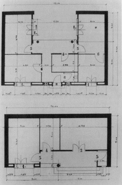
Figure 64.
Seiller and Lathuillière, housing project in Clos Salembier, plans of two house types, 1936.
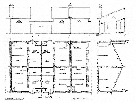
Figure 65.
Louis Bonnefour, indigenous housing project in Maison-Carrée, plans, sections, and facades, 1932.
few exceptions, direct communication between rooms was not provided for. The attached single-story houses had prototypical U-shaped plans, with courtyards that gave access to all interior spaces. The overall plan thus recalled an extended family compound, as studied by Thérèse Rivière, for example.
The last housing project from this period is the cité indigène in Ste.-Corinne in Maison-Carrée, an industrialized suburb of Algiers. In 1933, an official document recorded two quartiers insalubres in Maison-Carrée: a "village of negros" (village nègre ) and Ste.-Corinne, both deemed "unacceptable." Several measures were taken to reorganize the quarter, in addition to building a new housing project.[6] An early scheme prepared by Louis Bonnefour, an architect practicing in Algiers, proposed a continuous framework of houses with shared side and back walls (Fig. 65). The exterior facades had minimal openings—an entrance door, a bathroom window, and a triangular ornamental window for ventilation. One pitched roof sheltered two units, back to back. Organized by an ever-extendable grid, each unit consisted of two rooms, a court with a water outlet, a separate toilet, and a sheltered area.
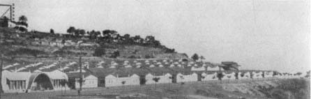
Figure 66.
Socard, low-rise cité indigène, view, 1951.
The rooms opened onto the courtyard, intended as the heart of the house. There was no separate kitchen or facilities for cooking, most likely justified by studies of traditional housing and women's domestic work. The fireplace in the main room could be used for cooking as well as heating the house. Because the water outlet was in the courtyard, accommodations for cooking were not coordinated, setting a precedent for future kitchen designs, which remained problematic.
A couple of years later, in 1935, architects Guérineau and Bastelica reinterpreted this scheme and increased the density by superposing another unit on top of two neighboring units while maintaining the internal organization of each unit. The cité indigène in Ste.-Corinne did not resolve the hygiene problem in Maison-Carrée outlined in the 1933 report, but it did introduce a long-lasting typology. As argued by Deluz, the minimal living spaces and the inner private courtyards with water outlets and toilets, derived from "traditional" houses and supposed to answer the needs of Algerians, were later incorporated into high-rise blocks.[7]
Another scheme to shelter two thousand Muslims in the Climat de France area to the west of the casbah also dates from 1934, although its execution had to wait until the end of World War II. By the early 1950s, two new settlements were built here: a "horizontal" development, consisting of parallel rows of two hundred single-story units, and an apartment building complex known as Boucle-Perez. The first, also referred to as Cité Climat de France, was later extended to incorporate ten thousand units. Architect Tony Socard designed the core settlement with groups of two houses whose courts shared a party wall. Constructed in a prefabricated system, they could be reproduced easily (Fig. 66). Each house had two or three rooms under a tiled, pitched roof, and there was

Figure 67.
Bienvenu, Boucle-Perez housing project, overall view, 1952.
a toilet in the courtyard, repeating the pattern set by the Ste.-Corinne housing and referring back to the "traditional" house.[8] The ornamental framing of the windows facing the streets was intended to secure privacy for the family. The bold expression of the geometric patterns generated by the prefabricated elements and the formal qualities of the window and ventilation frames, derived from the rural vernacular, enlivened the facades in a vocabulary familiar to the modernist architecture of Algiers—showing particularly the influence of Auguste Perret. Some communal facilities, such as a clinic and a nursery, were also projected for this neighborhood, in addition to eight shops. The site plan formed
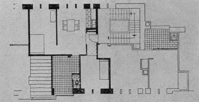
Figure 68.
Bienvenu, Boucle-Perez housing project, plan of a unit, 1952.
a grid, with stepped streets which climbed the hill and were interrupted by platforms at individual entrances.
The Boucle-Perez housing block, designed by François Bienvenu and intended for the resettlement of the populations evacuated from the Marine Quarter, was situated on Avenue Ahsan. While it belongs to the same typology as the Boulevard de Verdun project, its relative distance from the casbah freed the architect from stylistic references to the architecture of the old city (Fig. 67). Bienvenu organized the project as one building, a perimeter structure that surrounded a communal court. The court was reached from Avenue Ahsan by a monumental stairway; a new mosque on the other side of the road, but on the same axis as the stairway, provided the community with an essential amenity and created an architectural vista. A secondary street that cut through the lower part of the project and ran parallel to the avenue activated the inner landscape of the complex. The communal court acted as the main focus with shops on the ground floor. The overall symmetry of the composition around the court was broken up by the varying heights of the buildings, the tallest reaching six stories. The density and the "picturesqueness" of the resulting cluster referred to the casbah without mimicking it. The individual units consisted of two or three rooms with a kitchenette in the living room, and a deep and sheltered "patio," intended to duplicate the traditional courtyard, where the toilet was located (Fig. 68).[9]
This configuration, based on adapting a rural pattern into an urban typology, had serious shortcomings. Mainly, it worked against the intended use of the patio as an open-air living room and turned it into a secondary space as an extended bathroom and storage area. In some
cases, the residents enclosed it to gain an extra bedroom. Two problems contributed to the transformation of the patio: the fact that the apartments were often inhabited by more people than intended and the poor quality of the plumbing, which stemmed from corners being cut during construction. Despite the obviousness of these deficiencies from the first, the same pattern was repeated in many housing projects.