Cartographies of Discovery
The etymological roots of geography suggest that this was a science born of writing—a way of knowing that was tied in the most intimate way to scriptural activity. Today, we are accustomed to thinking of geography as a discourse whose primary vehicle of expression is not the sentence but the figural language of maps. Yet cartography, from its origins in Antiquity through the Middle Ages and into the sixteenth century, has been ever an accessory to, and product of, geographical writing. Perhaps because their technical imprecision precluded them from "speaking for themselves," early maps typically served as visual images of the verbal descriptions of the world contained in books like Pierre d'Ailly's Ymago Mundi (1480
or 1483), a work Columbus owned and annotated prolifically.[13] Cartography, then, was not an independent and autonomous form of geographical discourse but an illustrative art, supplemental to geographical writing. With the rise of Christianity and its dogmatic geography, which privileged the authority of Sacred Scripture over empirical observation, European cartography became primarily a hermeneutical practice devoted to the visual interpretation of the spiritual significance of the physical world as defined by Christian Scripture.
A brief consideration of the cartographic consequences of the rise of Christian geography is instructive on this point. Ptolemaic maps organized the world on a grid. Trapezoidal in shape, these maps have no focal points and are centered only to allow the oikoumene , the "known world," to be fully spread out within the confines of the grid. Samuel Edgerton puts it this way:
No part of Ptolemy's map was emphasized as having ideological significance. It was completely ecumenical and nonmystical. Whereas Ptolemy assumed the central meridian to pass through Syene, in later versions it was moved slightly eastward, though the map center itself remained on the latitude of the Tropic of Cancer, which ran through Syene. One might even say that, aesthetically, Ptolemy's design was "positional attenuating," since it deemphasizes the center and stresses instead the spreading of the grid in all directions from the perimeter.[14]
The Ptolemaic world map reproduced here (Figure 2) is from a Latin edition of Ptolemy's Geographia (Rome, 1472). Columbus studied and annotated the 1478 edition of the work. The Geographia was not known in Europe until the 1470s, and although it exerted a profound influence on the geographical thought of the waning Middle Ages, Columbus's attitude toward it was somewhat critical.[15]
Christian geography, on the other hand, placed Jerusalem at the center of the world, reflecting its ideological privilege as Center of the Faith. The earliest Christian maps often did little more than interpret figurally and schematically the teachings of the Church, rendering Jerusalem as umbilicus regionis totius surrounded by Asia, Europe, and Africa, all within a circle or rota . These "wheel" maps, also known as the T-O mappaemundi (Figure 3), situated the East, thought to be the location of the Terrestrial Paradise, at the upper
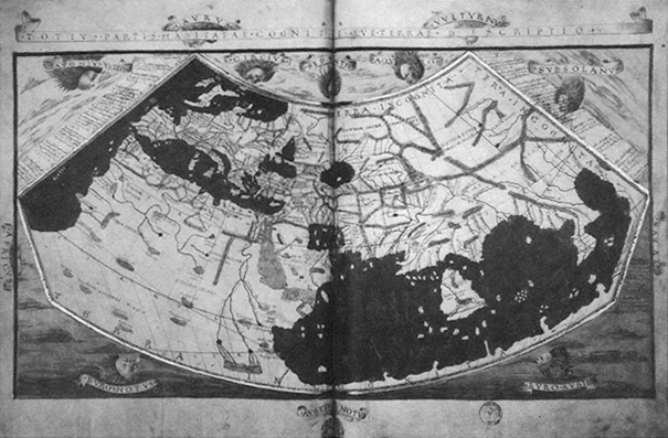
Figure 2.
Claudius Ptolemy, world map. From the Geographia (Rome, 1472). Courtesy of the American
Geographical Society Collection, Milwaukee, Wisconsin.
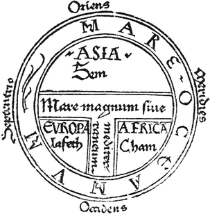
Figure 3.
Isidore of Seville, T-O mappamundi, 1472. Courtesy of the
Newberry Library, Chicago.
extremity, instead of the North. The T, which crossed at Jerusalem, represented the rivers and seas separating the three known continents. The image was oriented vertically, with its ideological meridian connecting the center at Jerusalem with the Earthly Paradise at the apex of the map. A more elaborate variation of the T-O model is the Ebstorf map (c. 1240) which shows Jerusalem at the center, highlighted by the image of Christ, a patch of gold leaf, and the Terrestrial Paradise at the top (Figure 4). A unique feature of this map is the inscription of Jesus' head, hands, and feet at the four cardinal points. The symbolism is clear: the world is Christ's crucified body, Jerusalem his navel, and the limits of the world are bounded and defined by his reach. As David Woodward has noted, the hermeneutical function of the mappaemundi appears to have grown increasingly important and complex.[16] Once simple book illustrations, the maps were, by the fifteenth and sixteenth centuries, placed on the first or second page of a codex, perhaps reflecting the heightened role cartography played in giving the reader an ideological
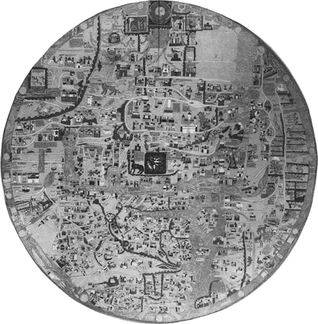
Figure 4.
Ebstorf mappamundi, c. 1240. Courtesy of the William L.
Clements Library, University of Michigan.
preview of the written text. In any case, the relationship between text and map was an intimate one: the text was the source relied on for the verbal directions used to create the map, and the map in turn functioned as a figure of the text.
In this respect mappaemundi were not significantly different from the other medieval cartographic genre, the portolan chart, a term derived from portolano , the Italian word for the written sailing directions. The portolanos are generally considered to be the precursors of the late-fifteenth- and sixteenth-century roteiros (rutters).[17]
The portolan charts were companion pieces to the written directions, which recorded coastal features, ports, islands, winds, currents, distances, and the like, based on practical knowledge obtained through actual travel experience. Like the mappaemundi , the portolan charts were intimately related to geographical writing, and each cartographic genre's pictorial mode of representing geographical objects illuminates the modalities of textual geographies and the travel genres that are informed by them.
Most scholars today assume that written directions guided the drawing of maps. The complementary relation between writing and cartography was underscored by Columbus when he proudly announced to the Crown that he would deliver text and maps representing and confirming his discoveries. He makes his most explicit statement on the twin aspects of the geographer's task in the "Relación del tercer viaje," when he refers to the authorities he consulted in the formulation of his geographical theories as "aquellos qu'escribieron e situaron el mundo" (Varela, 203; those who wrote about and situated the world). To understand the cartographic tradition that informed Columbian geography, we must take a few moments to examine the two cartographic genres—the mappaemundi and the portolan chart—and their ideological and formal differences.
Tony Campbell identifies the main characteristics of portolan cartography as spatial precision, realism, and historical accuracy.[18] The oldest surviving charts, attributable to Genoese mapmakers of the thirteenth century, already demonstrate the desacralized materialistic conception of space that typifies the genre. Both the historical moment in which these charts proliferated (late 1200s to the early 1500s) and their character suggest that they were drawn to satisfy the practical needs of sailors and merchants involved in the increasingly intensive trading activity along the Atlantic coasts of Europe, northwestern Africa, and the Mediterranean and Black seas. They are composed of a single bold and unbroken line which traces the coastal features with such precision that even the oldest charts very closely approximate the actual outlines of the Mediterranean and Black seas. The extant charts are striking in the clarity and exquisiteness with which they depict their intricate coastal geographies. Strings of place-names also helped define toponymically the political and economic contours of the geography. Political jurisdiction and economic importance were highlighted through changes in the color of ink and the use of flags. In this way, portolan cartography
was responsive to historical change as well as to the expansion of hydrographic knowledge. Its range continually widened to accommodate new discoveries and revised content as fresh information became available; in this way, the charts acknowledged time as a dimension in the experience of geographical space.
Although portolan charts vary considerably in the degree of decorative detail they contain, they consistently exhibit an austere realism with respect to their primary objective, the depiction of coastal geography. Decoration typically was limited to internal or marginal areas of the map that contain little geographical information. Decorative elements seem to function simply as embellishment or highlighting, unlike the mappaemundi , where decoration was usually at the behest of an intense geographical symbolism.
The portolan cartographers also depicted imaginary or legendary islands in the Atlantic with the same straightforwardness. Such fabulous names as Legname, Corvi Marini, San Zorzi, St. Brendan's Isles, Brazil, and so forth often appear in the vicinity of known islands like the Canaries and the Azores. Some early rutters even give distances to some of these mythic islands, underscoring the literal way in which these maps were interpreted. An especially striking example of this imaginary insular geography is found on the Pizzigano Chart of 1424 (Figure 5). Starkly functional in appearance and among the least ornamental of portolan charts, the document's portable size and shape, even the way it was rolled for storage, suggest that it was intended for regular practical use, not for display. The Pizzigano Chart was almost certainly created for use in Atlantic navigation, since only those coasts and the westernmost portion of the Mediterranean are represented. Nevertheless, it prominently situates several fantastic islands in the western Atlantic (Antilla, Satanazes, Brazil, Ymana, etc.) in a matter-of-fact fashion difficult to distinguish from that used to depict the real insular geography.
The Canepa Chart of 1489 (Figure 6), as geographically complete and sophisticated as any of its contemporaries, also depicts a legendary insular geography in the Atlantic without distinguishing it from the known islands. According to Ferdinand Columbus, it was precisely the belief in the existence of such islands that reassured his father about the feasibility of the long transoceanic passage (Vida , 51). It is very probable that Columbus employed just such a chart to plan his navigation and illustrate his proposal at court. In fact, the only cartographic drawing we have from his hand, of the
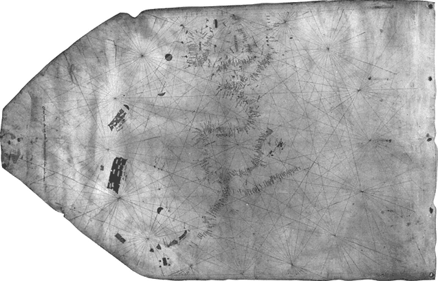
Figure 5.
Zuane Pizzigano, portolan chart, 1424. Courtesy of the James Ford Bell Library, University of Minnesota.
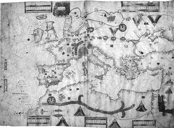
Figure 6.
Albino de Canepa, portolan chart, 1489. Courtesy of the James Ford Bell Library, University
of Minnesota.
northwest coast of Española (Haiti), appears to be a preliminary sketch for an eventual chart and is informed by portolan functionalism, realism, and accuracy.[19] A detailed description of a map of the discoveries composed for the Crown by Columbus has survived in a carta-relación of the second voyage, dated January 1494:
Verán Vuestras Altezas la tierra d'España y Africa y, en frente dellas, todas las yslas halladas y descubiertas este viaje y el otro; las rraias que ban en largo amuestran la ystançia de oriente a Oçidente, las otras questán de través amuestran la ystançia de setentrión en ahustro. Los espaçios de cada rraia significan un grado, que e contado çinqueta y seis millas y dos terçios que rresponden destas nuestras leguas de la mar, catorze leguas e un sesto; y ansí pueden contar de oçidente a oriente como de setentrión en ahustro el dicho número de leguas.... E para que podrán ver la distançia del camino ques d'España al comienço o fin de las Yndias, y verán en quál distançia las unas tierras de las otras rresponden, berán en la dicha carta una rraia que pasa de setentrión en austro, ques vermeja, y pasa por çima de la ysla Ysavela sobrel Tín d'España, allende del qual están las tierras descubiertas el otro viaje, y las otras de agora, de acá de la rraia, se entiende; y espero en Nuestro Señor que cada añmucho abremos de acreçentar en la pintura porque descubrirá continamente.
(Rumeu, 2: 451–52)
Your Highnesses will see the land of Spain and Africa and, in front of them, all of the islands found and discovered on this voyage and the other one; the lines that run lengthwise show the distance from east to west, the others that run horizontally show the distance from north to south. The spaces between each line represent one degree, which is comprised of fifty-six and two-thirds miles that correspond to fourteen and one-sixth of our sea leagues; and thus you can count from west to east, like from north to south, the said number of leagues.... And so that you can see the distance of the route from Spain to the beginning or end of the Indies and see the distance between particular lands, you will find on said chart a red line that runs from north to south and passes over the island of Isabela on top of Tín d'España, beyond which line are the lands discovered on the other voyage, and on this side of the line lie the other ones from [this voyage]; and I have hope in Our Lord that each year we will have to enlarge the map because he will continuously discover [new lands].
What Columbus describes was probably a portolan-style map, similar to the well-known Juan de la Cosa Map (c. 1500), oriented toward the Atlantic from the west coasts of Europe and Africa, and including all of the already-discovered insular geography in the western Ocean Sea, a region that on pre-Discovery charts had also been depicted, but only hypothetically.[20] Columbus's chart included lines of longitude and latitude, according to his description, that facilitate a more accurate assessment of distances, and a red line passing through Isabela marks the boundary between the discoveries of the first and second voyages. Just as portolan charts expanded and evolved in response to new information, so Columbus's map, he anticipates, will grow yearly when new discoveries come to light.
In contrast to the realism of the portolan genre, the cartographic discourse of the mappaemundi is characterized by its figurative dimension. A rubric on the Ebstorf map illuminates this aspect, underscoring the image's anagogical significance: "A map is called a figure, whence mappamundi is a figure of the world."[21] The body of Jesus inscribed on this map is a particularly clear example of this function: the disk containing the world, which is in turn contained by the body of Jesus, can be interpreted iconically as the Host, symbolizing the communion of all nations in the body of Christ. Whatever real geographic information these maps may contain, their primary function is hermeneutical; the representation of geographical reality is subordinated to the promotion of a particular spiritual interpretation of the world.
Mappaemundi also appear to have played an important role in the motivation of spiritual forms of travel. The Haldingham map in the Hereford Cathedral was periodically expanded by its makers, who added place-names taken from various written itineraries of religious travelers. Such a map could have served both the commemorative purpose of recording actual pilgrimages and the rhetorical one of stimulating new travelers to undertake a like journey by providing a model for emulation and planning. Whatever the purposes of such emendations, the map itself is a figure of the spiritual goals and significance of the journey. Mappaemundi defined a geography whose essentially figurative, schematic, ahistorical character could hardly have served the traveler's practical needs for precise directions or distances. Yet the promise of redemption they proclaimed in their metaphorical ordering of spaces—for example,
situating the favored destinations of real and mystical pilgrimages (Rome, Jerusalem, and the Terrestrial Paradise) on the same ideological meridian—encouraged the traveler toward his or her destination, itself a figure of the spiritual goal. These maps, although they may appear absurdly fanciful to the modern viewer, were responsive to the purposes for which they were designed: the promotion of a Christian ideology of space and the stimulation of real and imaginary spiritual voyages which would enact that ideology through actual or imaginative experience.
Although cartography may seem the most static and atemporal of discourses, maps are nevertheless profoundly chronotopical; they represent time-space in an ideologically coherent image of the world (understood as a spatiotemporal reality, as in the phrase "the end of the world"). For example, portolan geography is so inscribed in a particular historical moment that the temporal coordinates of undated portolan charts usually can be approximated with a considerable degree of accuracy. Moreover, their historical realism and toponymic specificity mirrors the literalism of the portolano and the temporal exactingness of later rutters. When these maps are read in conjunction with the written record of the voyage they were intended to complement, their functional temporal character intensifies as each location on the map acquires a concrete time value in relation to every other relevant point on the trajectory. From this perspective, every location becomes a time-space coordinate of the navigation as well as a place existing at, and significant at, a sgpecific historical moment. Mappaemundi are equally, although distinctively, chronotopic. In contrast to the functionalism and materialism of portolan charts, they represent a metaphysical view of time-space, a spiritual chronotope, that is defined by the spatial continuity between Earth and the Other World (Heaven or Hell) and the secular-sacred temporal continuum that is the history of salvation. Time and space are conceptualized as essentially limitless, bounded only by the figure of Christ, the measure of whose infinite and eternal reach defines the spatiotemporal contours of the Ebstorf map.
The term mappamundi was also used generically well into the eighteenth century to mean a verbal geography, a usage that further blurs the distinction between text and map. In implying that the geographical text is like a map, the metaphorical acceptation suggests that just as writing helped define cartographic images, so did
maps influence the articulation of spatiotemporal fields in texts. From this point on, I will use the term "textual cartography" as shorthand for the notion that maps informed the chronotopes of geographical writings, just as writing informed the chronotopes of cartography, from the Middle Ages and into the modern period.[22] To put it another way, geographical texts construct time-space much in the way maps do, and in their articulation of space, journeys reflect the particular cartographies that inform them. Map and text are thus complementary and even indispensable modalities for articulating the discovery experience.
Approaching the Columbian texts from this perspective offers two important advantages. First, by conceiving the geographical image as the product of a particular type of experience, we can discuss the geographical and epistemological aspects of the Discovery as related issues. Second, this reading strategy, akin to the practice of placing maps in the opening pages of a book to guide the reader through the textual cartography beyond, matches the strategy of representation favored by Columbus in the prologue to the Diario :
También, Señores Prínçipes, allende de escrevir cada noche lo qu'el día passare y el día lo que la noche navegare, tengo propósito de hazer carta nueva de navegar, en la cual situaré toda la mar e tierras del mar Occéano en sus proprios lugares, debaxo su viento, y más componer un libro y poner todo por el semejante por pintura, por latitud del equinocial y longitud del Occidente.
(Varela, 17)
Also, my Lord Princes, besides writing down each night whatever I experience during the day and each day what I sail during the night, I intend to make a new sailing chart. In it I will locate all of the sea and the lands of the Ocean Sea in their proper places under their compass bearings and, moreover, compose a book and similarly record all of the same in a drawing, by latitude from the equinoctial line and by longitude from the west.
(Dunn & Kelley, 21)
Once a mapmaker by trade, Columbus took pride in his cartographic skills long after his successes as a mariner and discoverer had made him a name.[23] In a letter addressed to the Catholic Monarchs (1501) included in the Libro de las profecías , he boasted of his God-given abilities:
A este mi deseo fallé a Nuestro Señor muy propicio y ove d'El para ello espírito de inteligençia. En la marinería me fiso abondoso, de astrología me dio lo que abastava y ansí de geometría y arismética y engenio en el ánima y manos para debusar espera, y en ella las çibdades, ríos y montañas, islas y puertos, todo en su propio sitio.
(Varela, 277)
For this my purpose I found Our Lord very favorable and he gave me the intellectual enlightenment for it. In seamanship he endowed me generously, in astrology he gave me what was necessary and likewise in geometry and arithmetic, and the talent and hands to draw a sphere and upon it cities, rivers and mountains, islands and ports, all in their proper place.
That Columbus consulted maps of various kinds to plan and carry out his navigations is obvious, but it is also quite likely, as Paolo Revelli has noted, that aboard his vessels were both portolan charts of the eastern Atlantic and mappaemundi depicting the uncharted Asiatic geography of the western Ocean.[24] In any case, numerous references by Columbus to both of these cartographic genres in the accounts of the voyages confirm that he sailed with two very different cartographic images in mind: a portolan one, which guided the navigation, and a hermeneutical one, which aided him in interpreting the nature and significance of the new geography he was encountering. The two following passages concern the same insular geography, but the first is informed by a practical portolan cartography, the second by the spiritual paradigms of the mappaemundi :
Este día ovo mucha calma y después ventó, y fueron su camino al Güeste hasta la noche. Iva hablando el Almirante con Martín Alonso Pinçón, capitán de la otra caravela Pinta, sobre una carta que le avía enbiado tres días avía a la caravela, donde, segund pareçe, tenía pintadas el Almirante ciertas islas por aquella mar, y dezía el Martín Alonso que estavan en aquella comarca, y respondía el Almirante que así le pareçía a él; pero puesto que no oviesen dado con ellas lo devían de aver causado las corrientes, que siempre avían echado los navíos al Nordeste, y que no avían andado tanto como los pilotos dezían. Y estando en esto, díxole el Almirante que le enbiase la carta dicha, y enbiada con alguna cuerda, començo el Almirante a cartear en ella con su piloto y marineros.
(Varela, 24)
This day there was much calm and later it blew and they went on their way west until night. The Admiral began talking to Martín Alonso Pinzón, captain of the other caravel, Pinta, about a chart that he had sent to him on the caravel three days before, on which the Admiral had apparently drawn certain islands in that sea; and Martín Alonso said that they were in that region and the Admiral answered that so it seemed to him, but since they had not encountered them it must have been caused by the currents which always had driven the vessels northeast and that they had not traveled as far as the pilots said. And at this point the Admiral said to send the said chart to him. And it having been sent over by means of some cord, the Admiral began to plot their position on it with his pilot and sailors.
(Dunn & Kelley, 41–43)
Maravillóse en gran manera de ver tantas islas y tan altas y çertifica a los Reyes que desde las montañas que desde antier a visto por estas costas y las d'estas islas, que le pareçe que no las ay más altas en el mundo ni tan hermosas y claras, sin niebla y nieve, y al pie d'ellas grandíssimo fondo; y dize que cree que estas islas son aquellas innumerables que en los mapamundos en fin de Oriente se ponen. Y dixo que creía que avía grandíssimas riquezas y piedras preçiosas y espeçería en ellas, y que duran muy mucho al Sur y se ensanchan a toda parte. Púsoles nombre la mar de Nuestra Señora. Dize tantas y tales cosas de la fertilidad y hermosura y altura d'estas islas que halló en este puerto, que dize a los Reyes que no se maravillen de encareçellas tanto, porque les çertifica que no dize la çentessima parte: algunas d'ellas que pareçía que llegan al çielo y hechas como puntas de diamantes.
(Varela, 57–58)
He marveled greatly to see so many and such high islands, and he assures the sovereigns that it seems to him that there are no higher mountains in the world than those he has seen since day before yesterday along these coasts and on these islands, nor so beautiful and clear, without mist or snow; and at their feet very great depth. And he says that he believes these islands are those innumerable ones that in the maps of the world are put at the eastern end. And he said he believed that there were great riches and precious stones and spices in them, and that they extend very far south and spread out in all directions. He gave them the name Mar de Nuestra Señora... [In contrast to Varela, Dunn and Kelley insert a note from the margin in the text proper at this point.] He says so many and such things about the fertility and beauty and height of these is-
lands that he found in this harbor that he says to the sovereigns that they should not marvel that he praises them so much, because he assures them that he believes he does not tell a hundredth part. Some of them appear to reach the heavens and are formed like points of diamonds.
(Dunn & Kelley, 153–55)
These two passages exemplify the conceptual cartographic models available to Columbus for describing geographical spaces and the discursive transformation that takes place when one cartographic genre or the other informs the representation of the new geography. In the first passage, the articulation is informed by a navigational cartography, akin to that of the portolan chart on which the Admiral was plotting the fleet's course in order to find landfall. In the second passage, Columbus is relating to the Crown his interpretation of the significance of the geography he has experienced. The newly sighted islands are identified with the innumerable (hypothetical) islands that the mappaemundi situate at the end of the Orient. Consequently they are endowed with the poetic and spiritual inflections that characterize Christian orientalist geographical discourse. They are islands of ineffable wealth, beauty, and fertility, so extraordinary that a literal description does not suffice and the islands assume the metaphorical shape of diamonds rising toward heaven. Their spiritual value is inscribed symbolically in the name he gives them, Mar de Nuestra Señora (Sea of Our Lady), as he practices an onomastic cartography, tracing the route of the voyage through a figuratively Christian landscape that marks the continuity between this world and the Other.