Chapter Three
The Making of Kodaira
Community through Nomenclature
The proper object of history is not the past but the past-present-future relationship. Thus, it is under the auspices of furusato-zukuri that the land reclamation program engineered by the Tokugawa bakufu has become an absorbing subject of study in Kodaira. As I noted in the Introduction, this chapter has two related agendas. One is to analyze various remakings of "Kodaira's" past; the other is to construct from archival data a coherent literary portrait of the social, political, and economic circumstances of the Edo-period farm villages that were later amalgamated under the name Kodaira. Knowledge of the circumstances of both the shinden villages and the amalgamation of those villages as "Kodaira" contributes to the anthropology of Japan, but this knowledge also has been used by natives and by Kodaira City Hall.[1] The natives have used it for the purpose of revanchism, and city hall has used it to promote a "living history" within Kodaira.
The name Kodaira

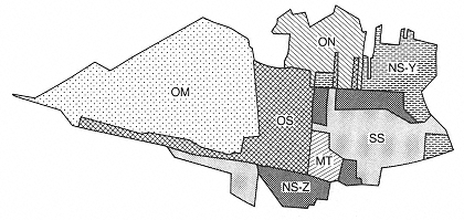
Map 3.
The "Kodaira Seven" shinden. OM = Ogawa-mura; OS = Ogawa-shinden; ON
= Onumata-shinden; NS-Y = Nonaka-shinden (Yoemon-gumi); NS-Z =
Nonaka-shinden (Zenzaemon-gumi); SS = Suzuki-shinden; MT = Megurita-
shinden. (Adapted from KK 1983, 80)
located within the boundaries of present-day Kodaira and were developed as independent villages. Delegates from each of these seven villages met to decide on an appropriate name for the new administrative village. They first considered the obvious name Shichiri, literally "seven villages," but eventually settled on Kodaira. Ko (the alternative Japanese-style reading for o ) means "small" and was derived from the "o" in Ogawa(-mura ). Taira, or "plain," was chosen in view of the Musashino area's flat topography (KC 1959, 403).
The very act of choosing and assigning place-names is a cogent means of generating "imagined communities" and particular solidarities. The term imagined communities was proposed in an "anthropological spirit" by Anderson (1983) to define nation-ness, nationality, and nationalism, which he further referred to as "cultural artefacts of a particular kind,"—lexicological, for example (ibid., 13–14, 101-2). To understand these and other such artifacts adequately, "we need to consider carefully how they have come into historical being, in what ways their meanings have changed over time and why, today, they command such profound emotional legitimacy" (ibid., 13–14).
"Imagined communities" characterizes both shinden village—making in the Edo period and the episodic making of Kodaira City, from the naming of the new administrative village in 1889 to Furusato Kodaira today. The name Kodaira has a peculiar kind of self-referentiality, because it enters into the very constitution of the community (cf. Searle
1984, 16). That is, a place-name is suggested by certain features and historical conditions just as it reconstitutes them under a systematizing rubric. What are the implications of the toponym Kodaira?
Ko was the prefix chosen in deference to the historical primacy of Ogawa-mura, which remains the city's most socially and geographically intact district. The integrity of this district also inheres in the fact that, of the seven amalgamated villages, its name alone was incorporated into the place-name Kodaira. By the same token, the administrative village of Kodaira acquired, through nomenclatural fiat, a historicity—Ogawa-mura' s—that belied its newness and artifice. It is no wonder that Ogawa Kurobei (d. 1669), who first set about reclaiming the village he then named after himself, has since been proclaimed the civic ancestor of all Kodaira residents. As noted above, the suffix taira was selected in view of the area's flat topography, and much symbolic value subsequently was invested in this flatness. The area's undistinguished landscape corresponds to its desolation prior to Kurobei's reclamation project. There is a confluence of signification between ko and taira insofar as they both allude in a specific sense to the historical personage of Ogawa Kurobei and in a general sense to the shinden pioneers as a hardy breed of settler in a virtual wasteland.[2]
The implications of the name Kodaira are also evident in the preamble to the Kodaira citizens' charter, promulgated in 1972. Three years later, in 1975, the wording of this preamble was contested by one of the six, at the time, Clean Government Party (CGP) assemblypersons. The assemblyperson pointed out that, although it provided the "spiritual structure" for citizen participation, the preamble nevertheless was inaccurate and misleading. He charged that the area was neither uninhabitable nor uninhabited prior to Kurobei, inasmuch as paleolithic settlements were present up to 20,000 years before any shinden villages were reclaimed in the Edo period. Mayor Oshima countered with the argument that the "modern historical development" of the area began with the reclamation of Ogawa-mura, which today is a source of spiritual inspiration for cooperative citizen participation. Therefore, "the wording of the preamble is suitable as is" (Oshima in KGR, September 1975, 166, 168).
Oshima's concern for historical accuracy was superseded by contemporary needs, the acknowledgment of paleolithic settlements not being among them. However, even efforts to publicize and popularize prereclamation history have served effectively to augment the imagination of a unique Kodaira. For example, in his various public lectures, Kato
Y., a Kodaira native and professor of archaeology at Kokugakuin University, draws attention to the uniqueness of "the city's" paleohistory. He emphasizes that nowhere in the world but Kodaira have so many "barbecued rocks" been found, his playful reference to the heated ferrous stones that the ancients had used for cooking purposes. Also, in one of the lectures making up the nine-week "furusato seminar" I attended, Kato referred to the paleohistorical inhabitants of the area as "'Kodaira Man,' a species of Cro-Magnon just like the one in Europe." This is not the occasion to challenge Kato's terminology; rather, his neologism illustrates the manner in which the area's ancient and more recent pasts alike have been assimilated under the rubric "Kodaira."
"Slogans and epithets are the materials out of which territorial sensitizing concepts are made" (Erickson 1980, 33). The place-name Kodaira, with its geohistorical reverberations, itself prompts these sloganized tributes to the shinden pioneers and the rigors of villagemaking. The citizens' charter (1977) of the neighboring city of Higashiyamato contains no reference to its sociohistorical legacy, apart from a reminder that it behooves citizens to learn about local history. Whereas both Kodaira charters refer to the city's historical "cultural landscape," the Higashiyamato charter dwells only on the physical environment: "Higashiyamato City is fortunate in being blessed with the natural beauty of Tama Lake and the forested hills of Sayama."[3]
A comparison of citizens' charters suggests that—among the twenty-six cities, five towns, and one village making up the Santama district—Kodaira is unique in drawing parallels and posing metaphorical links between the shinden village—making of the past and the furusato-zukuri of today.[4] The salient features of this shinden -based mythopoeia include pioneers and the intrepid pioneer spirit, the notion of social salvation through wasteland reclamation, local autonomy, and a hybrid philosophy of self-help and mutual aid.
Further explorations of the connections between yesterday's shinden village and today's Furusato Kodaira show that the analogies are reciprocal, for it is under the auspices of native place-making that village-making has become an absorbing subject of local historical study. The findings of these studies, moreover, have been appropriated in recent efforts to reclaim the "authentic" community presumed to have characterized the Edo-period shinden villages. Not only is the present-day city represented as a "natural" transformation of those villages, but the emphasis on authenticity has more to do with present-day needs than past realities.
The formation of Kodaira-mura itself has remained uncelebrated from the start. I offer the following explanation why. Through nomenclature, essentially two coexistent entities—two Kodairas—were created, one an amalgamation of seven villages, the other a symbiosis of Kodaira and Ogawa-mura. The name Kodaira effectively assimilated the historicity of Ogawa-mura: to commemorate Ogawa-mura's reclamation is to be mindful of Kodaira's beginnings, and vice versa. Thus, one constantly encounters in city publications such anachronistic statements as "Kodaira's origins in 1656" and "Kodaira's pioneering ancestor, Kurobei" (KGR 1982, 16–17). By the same token, Kyoda Kodaira, an abridged local history used as a city school text, devotes a quarter of the 120-page chapter on local history to Ogawa-mura (Kyodo Kodaira henshu iinkai [1967] 1983). Kurobei's biography and the genealogy of the Ogawa household alone span eight pages. Moreover, Ogawa-mura features prominently in the sections dealing with shinden -village life and work. Neither the founders nor the beginnings of the other shinden villages similarly are observed as civic causes célèbres.
The lopsided relationship between Kodaira and its constituent shinden villages highlights and reinforces a palpable microlocal patriotism on the part of Ogawa-mura natives. To be sure, Kodaira natives as a whole comprise an integral, self-conscious society vis-à-vis the fractionated newcomer sector, but within the natives' society Ogawa indigenes perceive of themselves, and are perceived by others, as Kodaira's "really real" natives. The implications of this civic favoritism, as it were, ramify in a number of domains, from the geohistorical to the religious and politicoeconomic. Since religious creeds and consociations are the subject of chapter 4, and forms of neighborhood organization and association are discussed in chapter 5, my focus in this chapter is on the sociohistorical making and remaking of Kodaira, beginning with the reclamation in 1656 of Ogawa-mura.
Ogawa-mura and the Musashino Shinden
Kurobei, who initiated the reclamation of Ogawa-mura, hailed from Kishi-mura (Musashimurayama City). According to the 1668 and 1669 cadastral registers (kenchicho ), Kishi-mura consisted of sixty-one households. The Ogawas were one of the eight households owning more than a hectare (about 3.5 hectares altogether) of dry field.
Fifty-three households owned less than one hectare of dry field, and thirty-five owned less than half that amount. Kurobei's shinden project was not included in the area surveyed. The relative affluence of the Ogawa household has been linked to its former status as a vassal of the (Odawara) Hojo clan. The clan settled in the Kishi-mura area following its defeat in the protracted wars that culminated in the establishment of the Tokugawa bakufu in 1603. Local historians surmise that the Ogawas served the Hojo until its downfall, whereupon they turned to agriculture. It remains unclear, however, whether the Ogawas were in fact bona fide samurai based in Kishi-mura and, if samurai, whether they later relinquished this status to pursue an agrarian livelihood (KC 1959, 36–38; KK 1983, 44–47; Onuki and Otani 1964).
Current members of the Ogawa ie (household),[5] as well as other Ogawa-mura natives, favor the prestigious samurai-origins thesis. For the Ogawas, samurai status differentiates their ancestors from the motley lot of destitute settlers who typified the shinden pioneers; for Kodaira natives, the samurai status of the Ogawas distinguishes Ogawa-mura from shinden founded by ordinary farmers and/or merchants. Kurobei nevertheless shared with his fellow pioneers the undistinguished status of younger sibling. The vast majority of male settlers were second and third sons, for whom land reclamation provided an opportunity to establish a branch household.
Ogawa-mura was originally conceived not as a farming village but as a post station (shuku ). Located along Oume Road, a major east-west thoroughfare widened and repaired in 1596, Ogawa-juku —as the village was named in woodblock prints of the "famous views of Edo" genre—serviced the needs of travelers and traders. Kurobei himself reputedly was involved in the lime trade, the transport of lime and kaolin to Edo being a major reason for the repair of Oume Road. Vast quantities of these natural resources were needed for the construction and maintenance of Edo castle and the city residences of the military elite. They were transported by a post-horse relay system developed by the bukufu (Yamamoto 1984, 18–20). It was an efficient operation save for one drawback: the absence of an intermediate post station along a desolate stretch of Oume Road. In 1656—after the completion of the Tamagawa and Nobidome canals, which provided potable water—Kurobei petitioned the local magistrate (daikan ) for permission to reclaim the barren stretch of grassland. His ostensible purpose was to establish an intermediate post station; agriculture was, at the outset at least, a secondary objective. The following year, the elder councilor
(roju ) granted Kurobei official permission to reclaim a swath of land, bisected by Oume Road, extending from the Tamagawa and Nobidome watersheds in the west to Tanashi in the east. The eventual eastern border of the new village, however, was much shorter.
Geography assumed a major role in the reclamation of Ogawa-mura; for, apart from the need for a post station, the aridity of the land prompted the bakufu's favorable response to Kurobei's petition, since his development project would not exacerbate the chronic depletion of the flora necessary to make compost, the primary fertilizer used at the time. An overview of the bakufu's shinden policy provides some necessary background about the beginnings ofKodaira's native sector.
Apart from the truism that virtually all fields and paddies begin as reclaimed land, shinden is used here in a narrower sociohistorical sense to refer to paddies and dry fields reclaimed during the Edo period, often in conjunction with village-making, as was the case in the Musashino region (Furushima 1975, 213).[6] The bakufu pursued an active shinden policy from the start, and by the 1660s much of the most accessible land (i.e., upland, riverbeds, coastland) in the Kansai and Kanto regions had been reclaimed. The less accessible Musashino area remained untouched. One counterproductive consequence of this program was the depletion of wild grasses and foliage utilized as a natural fertilizer, for until the eventual shift to commercial fertilizers (oil cakes, dried sardines) and cash crops (cotton, tobacco) in the early nineteenth century, compost was widely used. To offset the existing damage, the bakufu discontinued its shinden policy and instead encouraged the reclamation of fallow paddies. At the same time, projects such as the reforestation of denuded riverbanks and the construction of dikes were initiated to prevent silting and flooding. Between 1600 and 1867, 997 farms were reclaimed, although the percentage of those that included the establishment of a village is not known (Kimura 1964, 5). However, since the presence of a village increased the tax base, it is likely that most shinden projects included, eventually if not at the outset, a village-making component.
By the early eighteenth century, land reclamation, perceived as an expedient means of increasing the tax base, once again was actively encouraged. This time, the least accessible land was targeted for reclamation. An advertisement for shinden investors and settlers was drawn up in 1722 and posted in Nihonbashi, in the heart of Edo. The response apparently was enthusiastic. Within twelve years, seventy-eight new villages were established in Musashino alone—the proverbial Musashino
shinden —including the villages that eventually were merged to form Kodaira.[7] This was twice the number of Musashino villages that were reclaimed during the entire seventeenth century (Kimura and Ito 1972, 31). According to a 1739 cadastral register (based on a 1736 survey), roughly 1,327 households were established in these villages, 407 of them in "Kodaira," which also boasted the shinden village with the largest number of households: Suzuki-shinden, with its 123 settler families, followed by Ogawa-shinden, with 89. Twenty-eight of the new villages contained five or fewer households (KC 1959, 101).
The Musashino shinden project represents a major reorientation of the bakufu's agrarian policy, for the object of this second reclamation campaign was not the usual paddy land but, rather, dry fields, which became an important source of taxes from approximately the eighteenth century onward.[8] Until this time, taxation was virtually synonymous with paddy (Furushima 1975, 238–72; Kimura 1964, 6; Kimura and Ito 1972, 14–15). In 1726 the government drew up a proviso for subsequent land registration surveys (in the Kanto region), in which the following categories of arable land were defined: honden, or old paddies/fields (land reclaimed prior to 1687); koshinden, or old shinden (land reclaimed between 1688 and 1716); and shinden (land reclaimed after 1716). According to this scheme, Ogawa-mura belonged to the second category, and the other "Kodaira" villages to the third. The suffix shinden eventually was dropped from the names of villages belonging to the second category, in order to distinguish them from those established after 1716 (Matsuyoshi [1933] 1955, 2, 10–20). Thus, the Ogawa-shinden reclaimed in 1656 came to be called Ogawa-mura.
In further contrast to shinden and koshinden, honden referred to land taxed on the basis of an estimated yield (kokudaka ), which in turn was assessed through land registration surveys (kenchi ) conducted on a countrywide scale between 1596 and 1673 (Kimura 1964, 2). Shinden similarly were assessed as their reclamation proceeded, although they generally were taxed at lower rates. Furthermore, shinden settlers were guaranteed a tax holiday known as kuwashita nenki, or "period under plow, " for a period of several years.
Although Ogawa-mura was not one of the seventy-eight proverbial Musashino shinden (its offshoot, Ogawa-shinden, was), it nonetheless was a shinden village in Musashino and, like the others, was characterized by an absence of paddies. It was also a meticulously planned village, one imprinted with Kurobei's signature. The following account of the making of Ogawa-mura dwells primarily on recruitment and settle-
ment procedures, and household and community composition and organization.
Making Ogawa-mura
Even before receiving bakufu consent, Kurobei set about recruiting personnel to the site. Would-be homesteaders had to petition him for permission to stake a claim in the new settlement. The petition was to be submitted by the aspiring homesteader's guarantor, usually a village head. It seems that Ogawa-mura was exceptional in requiring petitions; in most instances, would-be settlers simply purchased or rented shinden —a procedure "not unlike a real estate venture" (Katayama 1959, 188). Petitions served as a means of screening settlers. Kurobei also reserved the right to evict troublemakers, although whether he did so for the sake of the nascent community or with his own interests in mind is debatable.
Many of these petitions are extant, and my abridged translation of one of them, submitted in 1656 by the head of a village in the Oume region, illustrates the selective and strictly supervised nature of Kurobei's recruitment procedures.
Point: These two men who wish to immigrate to Ogawa-shinden [i.e., Ogawa-mura ] are upright and honest. However, should they break the law or misbehave, this guarantor will assume all responsibility.
Point: These conscientious men are not given to complaining, but in the unlikely event that they should enter a protest, this guarantor will assume all responsibility.
Point: Once granted a site, these men will immigrate upon notification from you. Should they by chance renege, this guarantor will force them to immigrate and assume the responsibility of building their house.
Point: In view of the fact that this is a post station, these men are horse owners and surely will agree to work on behalf of bakufu or village officials. Should they refuse, you are entitled to evict them from the village.
Point: These men are not Christians.[9] (KC 1959, 49–51)
Forty-seven aspiring settlers, all males, submitted petitions in 1656. Within a decade, their number had more than doubled, after which the number of petitions submitted slowed to an annual average of one homesteader. Settlement petitions were discontinued after 1680, ostensibly because the village's demographic profile and social structure
had stabilized, although the number of settlers continued to fluctuate (KC 1959,55).
Kurobei was not alone in selectively recruiting settlers. In a shinden village—making manifesto written in 1795, the author recommends the recruitment of "honest and diligent workers, for if the first settlers are disreputable, then the others who follow will be adversely affected" (Yoshida [1795] 1979, 128). In shinden where petition-based recruitment was not practiced, other means of social engineering were employed. Shingaku (Heart Learning) colleges, for example, were established in several shinden villages, such as Arakawa-mura in Kai province and Higashitsuge-mura in Iga province.[10] Village life was organized around the colleges. During the tedious months of land reclamation, Shingaku teachers would continuously recite humorous but edifying parables to foster in settlers a positive attitude toward the grueling labor (Ishikawa 1964, 132; Robertson 1979, 1984b, 1991).
Since Ogawa-mura was in an unattractive location, Kurobei solicited settlers by negotiating, on their behalf, post-horse relay contracts with seven nearby villages. He also guaranteed them a share of the nearly six hectares of tax-exempt land reserved for homesteads (KC 1959, 47). Many of the petitioners were from lime- and kaolin-producing villages in the Oume area, although there were also immigrants from the Kishi-mura area and a significant number from Iruma district in the north (ibid., 49). The immigration of male settlers proceeded eastward and southward from villages in the western and northern reaches of Musashino. None of the petitioners were from the south, and only two immigrated from the east (ibid.).
The same pattern of demographic mobility pertained to the females of settler couples. Most were from villages in the west and north. The sexist rationale given by male settlers for preferring northern brides was that, coming from poorer, non-paddy-farm villages, these women were less likely to complain about a coarse diet and more likely to be hard workers. The voices of female settlers are conspicuously absent from the historical and contemporary literature on shinden. Paddy-producing villages were regarded as higher in social status, and paddy farmers, predictably, were unwilling to relocate to dry-field shinden (Katayama 1959, 170–71; KC 1959,1187–89; TKSS 1969, 1244). The male and female immigrants to Ogawa-mura thus tended to be from lower-status villages in west and north Kanto.
It is not clear how many of those who petitioned to immigrate actually did so. According to the existing data, a little over half of the
| ||||||||||||||||||||||||||||||||||||||||||||||||||||||||||||||||||||||||||||||||||||||||||||||||
would-be homesteaders for the period 1656–1680 submitted their petitions within the first two years of Kurobei's recruitment drive (table 1). Since the number of petitioners does not correlate with the corresponding population figures, I surmise that not all the petitioners immigrated or that not all the petitions and petitioners are accounted for. Settlers from Kishi-mura probably were exempt from petitioning, since their backgrounds would have been known, although it is not clear how many homesteaders came from there.
The actual number of both applicants and settlers probably was significantly higher. Apart from the recorded figures, this likelihood is indicated by a 1662 petition, submitted to the local magistrate by disgruntled farmers in defiance of their shinden contract, in which is mentioned the ruination of 64 settler households: "the wives and children were sold as slaves in Edo and its environs, while the husbands took to vagrancy" (KC 1959, 58). It is not clear from this document whether these settlers absconded or were evicted by Kurobei. Given the existing data, their departure translates as a 78 percent population loss, which seems far too extensive under the circumstances. On the basis of the 1658 and 1664 figures, I estimated that the extant petitions amount to about 90 percent of the total submitted. Population estimates for 1658 derive from a petition of protest signed by 76 Ogawa-mura households at that time (KC 1959, 50). The 1664 land register accounts for 104 homesteads (ibid., 53), although only 95 petitions (90 percent) are extant. Perhaps the remaining 10 percent were immigrants from Kishi-mura. Finally, the gap between petitioners and homesteaders may also be explained in part by a significant number of settlers who either absconded or were evicted from the village soon after their arrival, as suggested by the 1662 petition cited above. The population of Ogawa-mura grew incrementally from 1713 to 1802, when it leveled off at 220 households (1,018 persons), which is the same number of households accounted for in 1857 (ibid., 177, 205). What the data show clearly is that Ogawa-mura attracted a relatively large number of settlers from the outset.
Ogawa-mura was reclaimed only after the completion of the Tamagawa canal, which ensured a dependable supply of potable water. Kurobei also secured a supplementary livelihood for the settlers: posthorse contracts with seven villages for the transportation of lime and kaolin to Edo. In addition, by relying on his own funds and network of contacts, he began selectively recruiting settlers before he received official permission to start his reclamation project. Indeed, it was Kurobei's consequent sense of proprietorship of land and settler alike that triggered the 1662 disturbance. It is also important to note that Kurobei himself had established a branch household on the shinden at the time of its reclamation. As village head, Kurobei was able to comprehensively engineer and supervise the making of Ogawa-mura.
The style in which Kurobei imagined the new community was autocratic. Ogawa-mura —apart from being his private domain, "bequeathed by the bukufu, " as he maintained—was also his "gift" to the
sorry lot of destitute farmers and younger sons (Kimura and Ito 1972, 69–70; Sunagawa no rekishi 1963, 23). In return, Kurobei expected certain "favors" from the homesteaders: compulsory "thank-money" of three mon per tan (about ten ares) of dry field and an additional charge of three sho (5.4 liters) of rice, to be paid through the settlers' grandchildren's generation (KC 1959, 50–52). The imposition of these fees, neither of which was a standard practice, demonstrates Kurobei's autocratic tendencies. As early as 1658, seventy-six settlers submitted a signed statement to Kurobei protesting these fees. And in 1662, just five years after the village was founded, nine persons representing the settlers as a whole submitted to him a petition in which they listed their complaints about his actions as village head.
The contents of the 1662 petition, my abridged translation of which appears below, partially reveal the extent of Kurobei's despotic exercise of authority.
Point: Since 1659, the settlers have not received even one mon from Kurobei [of the hundreds owed them] in payment for their post-horse services.
Point: Money from the local magistrate intended for the settlers in remuneration for post-horse services rendered him has been entirely confiscated by Kurobei.
Point: In 1656, the bakufu granted the settlers an emergency fund of 100 ryo, of which Kurobei distributed only 54 ryo. The remaining 46 ryo he claimed as his own funds, which he then lent to the settlers at interest. Since the money originally was intended for the settlers, they deserve repayment of a total sum of 48 ryo.
Point: Whenever Kurobei makes a round trip to Edo, eight farmers are obliged to transport him by palanquin all the way to Tanashi, regardless of whether it is raining and the roads are muddy. This is unforgivable!
Point: Daily for the past five years, four farmers have been forced like slaves to perform odd jobs for Kurobei, such as cleaning the stalls and cutting the grass at his residence.
Point: Sixty-four households have fallen into ruination—wives and children have been sold as slaves and the husbands have taken to vagrancy. Their abandoned houses have been sold at a profit by Kurobei.
Point: Kurobei has divided unfairly the profits accrued from the sale of melons to Edo. (KC 1959, 57–58)
Although the specific details of the case are not available, the dispute was mediated by two temples, Shosen-ji and Myoho-ji, established in Ogawa-mura at the time of its reclamation. The corvee seems to have been discontinued, for it is not among the complaints listed in a 1677 petition protesting actions by the village head. However, the disgrun-
tied settlers had to submit a statement to the effect that they would not cause any further disturbances (Kimura 1964, 121–23). By installing these two temples (which are discussed more specifically in chapter 4), along with two shrines at the outset of village-making, Kurobei effectively extended his control over the internal affairs of the new village. Long after the Ogawa household's politicoeconomic monopoly had loosened, temples and shrines retained their social centrality and today form the core of the native sector.
Whereas Kurobei's despotic style was not appreciated by the pioneering settlers, today he is honored as the civic ancestor of all Kodaira residents. The very character traits that so enraged the Edoperiod farmers are now lauded in local-history texts as those of a selfmade man. Nostalgic reappraisals of Kodaira's shinden past have cast the notorious Kurobei in a heroic light, while the immigrants are relegated to the shadows. In an article titled "The Peculiar Characteristics of the Ogawas," a local historian writes that Kurobei was widely known for his savoir faire throughout the Musashino region and that the Ogawas consistently have been paid the highest respect accorded to village heads. Evidence for the latter claim is based on the scale of their entranceway (genkan alone, "which may be compared to that of a samurai lord" (Ito 1961, 46). Entranceways were key symbols of authority and conceit among the Edo-period elite. Thus, in 1710 an Ogawa-mura villager was punished for having erected an entranceway much too fancy for his lowly kind (KC 1959, 77). The Ogawa entranceway was declared an "invaluable cultural property" and restored by the city in 1976, the year the citizens' festival was inaugurated. By glamorizing the Ogawa entranceway, the local historian and city hall have further contributed to shinden mythopoeia.
Despite their professed desire to "detail as accurately as possible the circumstances and particulars of the making of Ogawa-mura, since the village marks the beginning of what is today Kodaira," the editors of the Kodaira choshi (Local history of Kodaira, 1959) nevertheless have glossed over incidents of antinomy between the farmers and the village head. Perhaps to compensate, they occasionally remind the reader that "it was the sweat and toil of the farmers that made Ogawa-mura into such an outstanding village" (KC 1959, 63, 67). Although I use the Kodaira chioshi in constructing my portrait of early "Kodaira," I also make problematic this text and its designs. Plans to create a localhistory book were formalized soon after the town-merger campaign failed on account of farm householders' local patriotism. The explicit objective of the planners was to consolidate a Kodaira-specific identity
and to nurture a local-place consciousness, although the implicit objective was to rectify the image of Kodaira natives. Significantly, the project was hatched when Ogawa A., a descendant of Kurobei, provided a historian with Ogawa household documents (KC 1959, 1373–79).[11]
The editors of the Kodaira choshi claim that the comparatively rapid development of Ogawa-mura and the anti-village-head protests that occurred soon after its founding were related to the honbyakusho, or titled-farmer, system inaugurated by the bakufu in the seventeenth century. The idea was to expand the tax base by reducing the number of untitled, small-scale landholders and the landless and, concomitantly, increasing the numbers of self-sufficient landholders through such means as shinden reclamation. The titled-farmer system was in fact more evident in shinden villages proper than in old villages whose arable land was increased through reclamation (KC 1959, 31, 53–54, 176).
Settling Ogawa-mura
A feature of the nascent Ogawa-mura that, according to local historians and Kodaira natives, accounts for the configuration and integrity of the natives' society today was the allegedly equal distribution of shinden parcels. Kurobei is said to have distributed the parcels in an "egalitarian" fashion; the width of a homestead had nothing to do with a settler's relative status, for a broad frontage indicated a shallow parcel and a narrow frontage a deep parcel. Consequently, Ogawamura is trumpeted in the local literature as having been a promised land of equal opportunity. However, the following cadastral register figures all but erode this claim, making it difficult to believe that the homesteads actually were distributed equally from the outset.
As I noted earlier, Kurobei purportedly offered prospective immigrants a parcel of tax-exempt land. This was the yashikichi, or homestead, the size of which averaged 18 meters across and 45 meters deep. The parcels were aligned along either side of Oume Road, on which they fronted. Each homestead came with a house and several auxiliary buildings, a small service canal (i.e., the Ogawa branch canal, completed in 1657), and a windbreak. Behind each homestead, and just as wide, stretched a long plot of farmland divided into several sections according to arability. These generally included a swath of gebata, or low-grade field, 90.5 meters deep, and, behind that, two successive 181-meter
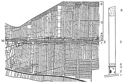
Fig. 9.
The ideal-type shinden parcel. 1 = Oume Road; 2 = homestead and
house; 3 = Ogawa branch canal; 4 = windbreak; 5 = fields; 6 =
forest. The Ogawa branch canal encircles the Ogawa-mura homesteads.
(Adapted from Yamamoto 1984, 35)
strips of gegebata, or low-low-grade field, ending in a stand of shrubs and trees. The entire parcel amounted to nearly one hectare (KC 1959, 64–65). Such a parcel constituted an ideal-type homestead and its attached farmland in the nascent Ogawa-mura (fig. 9). According to the 1669 cadastral register, the village comprised 106 shinden parcels, the smallest measuring about 14 meters across and the largest about 127 meters; the majority (59 parcels) measured 18 meters across.[12]
The number of homesteads owned by individual villagers similarly varied. According to the 1669 land register, seventy-eight settlers each owned one homestead; thirteen settlers owned two or more homesteads (Kurobei alone owned six); and five settlers had no homestead of their own. Virtually nothing is known about the situation of these "homeless" homesteaders. One possibility is that they were among the shinden landholders known as mochizoe, or holders of detached land. Some shinden, such as Megurita originally, were known as mochizoe shinden, since they were worked not by resident farmers but by commuters from, usually, the "parent" village. Ogawa-mura, however, was not within commuting distance from Kishi-mura. Another possibility is
that they may have been agricultural servants (genin ). From 1650 to 1700, ten such servants were contracted to work in Ogawa-mura for a period ranging from one to ten years, and the Ogawa household alone consistently employed from three to five servants (KC 1959, 178).
A plot of residential land is not the same as a residence, and thus the question of dwellings arises. Among the Ogawa household documents is a letter from Kurobei to the local magistrate, detailing the types of houses scheduled for construction on each homestead. Plans were submitted for houses for two, four to five, and six persons, with floor plans measuring 6.4 by 3.6 meters, 8.2 by 4.6 meters, and 9 by 5.5 meters. All three types were bordered on the south and east sides by a meterwide veranda, and all three consisted of, basically, two rooms: one floored in either bamboo slats or rice husks covered with straw matting, and the other in stamped earth. Walls were fashioned of straw, and material for the supporting poles was limited to chestnut. The roof was thatched with miscanthus (kayo ) (KC 1989, 87–89; Yamamoto 1984, 35–36). Kurobei's comparatively palatial residence stood in marked contrast to these minuscule huts—his entranceway alone was 3.6 by 1.5 meters (Ishihara 1964, 9). Precise details about the original house are not available, but it probably was at least nine times larger than the settlers' huts (Ishihara 1964, 6).
Since the huts were designed for two, four to five, or six persons, we may assume that these figures reflect the composition of settler households, although in what proportion is not known. The average size of a newly settled household is estimated to have been between three and four persons, two of whom presumably were a married couple. A newly established branch household probably consisted of a married couple without children (cf. Ogawa 1983).
Generally speaking, immigration to a shinden village offered younger sons from households of limited means an opportunity to strike out on their own, free from the encumbrances of an intra-ie hierarchy. This was especially true of shinden, such as Ogawa-mura, that were not offshoots of a parent village but were founded as villages in their own right. At the same time, however, the immigration of a branch household, despite its economic independence, constituted a means by which an ie could perpetuate itself, for the continuity of the ie transcended the constraints of an intra-ie hierarchy (cf. Kimura and Ito 1972, 120).
Within Ogawa-mura, homesteaders were organized as chien shudan, or place-linked groups. The peculiar conditions of Ogawa-mura in particular, and the Musashino shinden in general, either discouraged or
made unnecessary the so-called kyodotai system of communal landholding and labor (Ito 1966, 77, 81–82; Kimura and Ito 1972, 219). Although the term literally means "common body," kyodotai is a chameleonic sociological term, for its meaning depends on the persuasion of the user. Localists such as social historian Daikichi Irokawa regard kyodotai as "the historical basis of Japanese culture and society" and see in it the operation of democratic procedures and horizontal social relations (Irokawa 1973). Others, such as political scientist Masao Maruyama, insist that the operations of kyodotai preclude democratic procedures and circumvent horizontal relations (Maruyama 1969, 25–83). Shinden scholars tend not to treat kyodotai as a synonym for village community, and suggest instead that it denotes a type of agriculture characterized by communal property and water regulation, together with compulsory cooperation for their maintenance. According to this view, the prototypical kyodotai, or communal corps, is the wet-ricecultivating village, although the term has been used more diffusely to describe communal relations in fishing and forestry villages as well.
Kyodotai most commonly is used in reference to, and conjures up the image of, paddy fields, the complicated irrigation and labor-intensive cultivation of which has allegedly "created a very special form of rural, human organization" (Irokawa 1973, 80). As a popular term, kyodotai is fetishistic, for it is invoked, often nostalgically, as the "authentic" Japanese rural community, the implication being that farm villages inherently are cooperative. It thus connotes a pristine moral society, the resurrection and revalorization of which is the ultimate objective of furusato-zukuri campaigns today. An official at Kodaira City Hall remarked that kyodotai, "as a feature of wet-rice agricultural life," was purposely selected and adapted as a cogent furusato-zukuri motif. The irony is that such rural imagery was stimulated not by the historical reality of Kodaira's agrarian past but by the recent imagination of a community of paddy farmers.
What were some of the features of Ogawa-mura in particular, and the Musashino shinden in general? Ito (1966) has described three main features.
First, these shinden contained "relatively large" landholdings, each managed by a single household. The large size of landholdings in Ogawa-mura is attributed to the poor quality of soil and consequent low productivity; quantity, in other words, took the place of quality (KC 1959, 54) (table 2).
Second, there was a "rational" distribution of arable land. In Ogawa-
| ||||||||||||||||||||||||||||||||||||||||||||
mura, land distribution was rational insofar as the rectangular parcels were contiguously aligned along Oume Road, each with direct access to potable water. Kishi-mura, in contrast, was a cluster of farmhouses sandwiched between the Sayama Hills and a wide swath of tilled fields (map 4). Ogawa-mura, in short, did not conform to the ideal-type portrait of Edo-period villages comprised of scattered landholdings.
Third, the unfertile, loamy soil of the Musashino region necessitated the liberal use of commercial fertilizers. In addition to the rice chaff, ash, and night soil that they purchased, Ogawa-mura villagers utilized barnyard manure and compost made from herbage. Commercial fertilizers, especially rice chaff, increasingly were relied on as the advancing reclamation work reduced the amount of grassland. By the late eighteenth century, the high price of rice chaff created serious and perennial problems that remained unresolved through the end of the Edo period (KC 1959, 71, 182, 269–70, 278–84).
In Ogawa-mura, as in the Musashino shinden at large, there was no "common property" (iriaichi on which the villagers foraged for compost material. Forage land, formally referred to as "forest field" (hayashibata ), was individually owned, comprising as it did the lower portion of each homestead (Ito 1966, 81–82; Kimura and Ito 1972, 133, 140–42).
Ito does not include water use and control among his conditions, but the topic is relevant to this discussion. As noted earlier, kyodotai (communal corps) connotes a style of social organization based on the
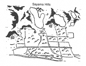
Map 4
Kishi-mura (1660s) and Ogawa-mura (1690s). Kishi-mura (top) was characterized
by a cluster arrangement of farm households, while in Ogawa-mura (bottom),
homesteads were aligned along Oume Road. (The map of Kishi is adapted
from Kimura and Ito 1972, 258; the map of Ogawa is adapted from
Ogawa-mura chiwarizu [Map of Ogawa-mura landholdings] n.d.)
requirements of wet-rice cultivation, paddy irrigation procedures in particular.[13] Modes of paddy irrigation varied considerably from region to region, but as a whole the meticulous complexity of paddy farming—the success of which hinged on a strategy of alternating periods of standing water, running water, and draining—contrasts starkly with dry-field farming in Ogawa-mura, where irrigation was synonymous with rainfall. Since Ogawa-mura was a dry-field shinden village, the mode of social organization associated with water use was different from that of paddy-cultivating villages.
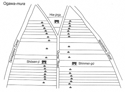
Whereas the Tamagawa main canal made the reclamation of Ogawa-mura feasible, it was the Ogawa branch canal that directly served the water needs of individual homesteads. The branch canal, dug at the same time that reclamation work was commenced, took the form of twin channels paralleling either side of Oume Road. Figuratively speaking, the long, narrow shinden parcels were the warp and the Ogawa branch canal the woof of, in the words of the "Kodaira Song," "an endless brocade of green." While many shinden in the Musashino area shared with Ogawa-mura a linear layout, it alone featured a symmetrically arranged set of service canals threading together the otherwise autonomous parcels.
Kodaira Song
The land, an endless brocade of green,
Ripe and fruitful Musashino, where hopes are sown.
Always progressing, Kodaira,
Carrying out ideals. Proud of
our pioneer past—the heart's native place.
Flowers blooming; pure the water flows,
Dreams too, onward, toward a distant future.
A bell tolls loud and clear. Kodaira
Bubbles with youthful vigor;
Academy town, fountain of culture
Gentle breezes gather the fragrance of tea petals,
Pristine Fuji, glistening Mitake—
Radiant light pours down, in Kodaira
People gather, a new
Peace is their aim, joyfully marching ahead.
Music: Shimosa Kan'ichi
Lyrics: Katsu Nobuo
Each household was responsible for the upkeep of its segment of the Ogawa branch canal. Part of the village code, compiled in 1715, included the following rules and regulations pertaining to this waterway.
Point: It is forbidden to dump trash and garbage into the canal.
Point: It is forbidden to play, launder clothes, or wash any soiled articles in the canal.
Point: Since the canal provides drinking water for the entire village, each homestead must keep its segment free of debris.
Point: Once or twice a year, each household is to dredge its segment of the Ogawa branch canal.
Point: It is strictly forbidden to tap the service canal by digging auxiliary ditches, however narrow they may be. (Ito 1984, 46)
The net effect of these rules and regulations, although they were carried out on an individual-household basis, was the regular maintenance of the entire village's potable water supply. This arrangement may have nurtured the development among Ogawa settlers of a "communal consciousness" (kyodo no ishiki ), which arguably is not the same as a "communal corps" (kyodotai ) (Ito 1984, 48). The rules and regulations pertaining to the Ogawa branch canal were mediated and enacted not by a collectivity but by individual households made conscious of the collective benefits of their individual role in canal maintenance. To interpret communal consciousness as the equivalent of a communal corps is an act of reification on the part of local historians.
Kyodotai is presented in the Kodaira literature as a collectivity limited to a single village, of and for which it is a metaphor. Significantly, the Kodaira choshi, in its diagram of the Tamagawa main canal as utilized during the Edo period, places the canal along the borders of the presentday city. The editors effectively have conflated what was, in effect, a multivillage, multilevel water delivery network to a geographic entity—Kodaira—created in 1889. What is imputed here is that the seven shinden villages were organically united before their arbitary merger in the late nineteenth century. The contemporary search for "authentic" community has taken precedence over historical accuracy.
Kumi (Divisions)
The Ogawa branch canal was maintained by individual households; the upkeep of the Tamagawa main canal was undertaken on a kumi basis. In its most general sense, kumi signifies an intravillage division, of which three basic types were operative in Ogawa-mura: nengugumi, or tax division; goningumi, or five-household division; and kinjogumi, or neighborhood division. The upkeep of the Tamagawa
main canal was the province of this last division. Each of these types of kumi in turn was further subdivided. Membership in all the divisions and subdivisions was largely compulsory and limited to titled farmers (honbyakusho ). The village head and the clergy, as privileged villagers, were exempt from having to participate in these organizations. Regardless of whether these intravillage divisions were "the brainchild of Kurobei," as one local historian has insisted, or instituted by bakufu decree, or both, they nevertheless were key elements in the making of Ogawa-mura.
Nengugumi
Functioning as units of tax collection and payment, nengugumi (fig. 10) were present in villages throughout the Kanto region. In some small villages, nengugumi either were absent or a single nengugumi coincided with the village proper (Kimura and Ito 1972, 213, 238). As a rule, nengugumi were supervised by a kumigashira, or division leader, after whom, in the case of Ogawa-mura, they were named. Generally speaking, this position, like that of the village head, was hereditary and, in the Kodaira shinden at least, limited to males. The "artificial, planned aspect" of the Ogawa nengugumi is evident in the fact that they were organized on the basis of "place links" (chien ), instead of "blood" and/or fictive kin ties, as allegedly was common in unplanned, "natural" villages (Kimura and Ito 1972, 213).
The Ogawa nengugumi passed through three phases of development. In Phase I, probably following the 1669 land registration, the homesteads were divided into ten tax divisions proceeding from west to east. Prior to the inauguration of the kumi system in general, Kurobei had designated his residence as the boundary separating the nascent village's two temple parishes, each of which originally functioned in a kumi -like capacity. In Phase II, another tax division, comprising land reclaimed since the 1669 survey, appeared in the 1674 cadastral register, bringing to eleven the total number of nengugumi. In Phase III, which took place during the 1720s, the existing eleven tax divisions were reorganized as eight larger units, which were retained as the official administrative divisions through the end of the Edo period (Kimura and Ito 1972, 213-14). These new units, moreover, were referred to as ichibangumi, ni-bangumi (first division, second division), and so forth. (Hereafter they are referred to as 1-bangumi, 2-bangumi, etc.)
The nengugumi, in short, were absorbed into a more comprehensive
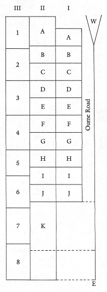
Fig. 10.
Ogawa-mura nengugumi. I, II,
and III signify the three successive
stages of development. A–K are
the kumi units, which preceded
the bangumi, 1–8. (Adapted
from Kimura and Ito 1972, 214)
system of village administration. At the same time, the jurisdiction of each division leader likely shifted to the bangumi. That the two temple parishes served as prototypical kumi during the decade after the village's founding is suggested by the fact that parish-related activities—memorial services, funerals, sutra-chanting coteries, exorcisms—eventually were organized on a bangumi basis. Today the bangumi remain intact as the system by which the native sector of Ogawa, now a district (cho ) of Kodaira, is organized both affectively and administratively. I refer to these bangumi collectively as the "Ogawa Eight."
The number of kumigashira did not necessarily coincide with the number of kumi. There were eleven division leaders in 1679, ten in 1700, nine in 1713, eight in 1733, and six in 1754 (KC 1959, 75). The decrease may be related to the practice of not appointing a substitute to complete the tenure of a division leader who either died or retired prematurely. Attrition probably resulted initially from the lack of a suitable heir and later from the decision that the post was dispensable.[14] The data suggest that some of the division leaders were among the original petitioners. Given the paucity of primary data, it is unclear whether some of the Ogawa-mura division leaders were appointed by Kurobei, although the probability is very high (Kimura and Ito 1972, 219, 228). In any case, the elite households that emerged during Ogawa-mura' s formative years have remained influential to the present day.
Ogawa-mura division leaders did not necessarily live in the tax division under their jurisdiction; neither did ordinary farmers. This arrangement seems to have been designed to circumvent the potential buildup of kumi loyalties. Even so, a given tax division was named after the current division leader. The nengugumi remained fixed geographic units until their comprehensive reorganization in the 1720s. A given tax division did not amount to a kyodotai, or communal corps. The tax divisions, rather, were arbitrarily determined geographic units, which in several instances were supervised by settlers lacking outstanding residential or kin connections. Furthermore, neither leadership nor membership was contingent upon kumi residence (Kimura and Ito 1972, 218–19).
Goningumi
The goningumi (fig. 11), or five-household division, was introduced by the bakufu in the 1620s as a means of more thoroughly articulating its authority at the local level. Within a village, the gonin-
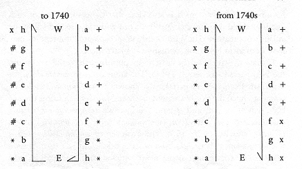
Fig. 11.
Goningumi registration. +, *, and # indicate goningumi groups, and
x signifies unaffiliated households. The goningumi households are
aligned along the north and south sides of Oume Road.
gumi functioned as a system of interhousehold surveillance and constraint, for the transgressions of one member would make the remaining four subject to castigation. The goningumi may be described as a janus-faced system of collective culpability and collective responsibility.
Aspects of the organization of this division are gleaned from the goningumi-cho, or register. Until roughly 1740, households were registered in groups of five, beginning with the westernmost and proceeding to the easternmost household on the north side of Oume Road, and continuing without a break from the easternmost to the westernmost household on the south side. From the 1740s onward, however, north- and south-side households were registered separately, from west to east and east to west, respectively (Kimura and Ito 1972, 151). Register entries clearly establish that in Ogawa-mura exactly five households comprised a goningumi, which was not always the case in other villages (ibid.; cf. Befu 1968, 304). Several households, consequently, were not incorporated into a goningumi. Perhaps their inclusion within the tax and neighborhood divisions was sufficient from an administrative point of view, a possibility I broach again in the context of the neighborhood divisions. Or perhaps only the households of titled farmers were incorporated. Also, the Shinto and Buddhist clergy, along with the village head, were exempt from this and other divisions. In Ogawa-mura, the goningumi did not coincide with the tax division, although there may
have been some overlap. It is also clear that the composition of each five-household division changed in accord with the rise and fall of the village's population. Thus, previously unincorporated households may have been included in the goningumi at a later time.
Ostracism was one of the most severe punishments meted out during the Edo period (see Smith 1961). The equivalent of murahachibu, or ostracism from the village(rs), was known as goningumi hazushi, or ostracism from the five-household division. Murahachibu seems to have been typical in "old" and "parent" villages, whereas goningumi hazushi characterized the system of sanctions in "new" or shinden villages (Kimura and Ito 1972, 157). The existence of goningumi hazushi is further evidence that Ogawa-mura as a whole did not operate as a kyodotai, or communal corps, from which errant households were ostracized.
Kinjogumi
Documentary evidence suggests that the kinjogumi, or neighborhood divisions (fig. 12), were in existence in Ogawa-mura by 1690, as were the goningumi. The neighborhood divisions were partly a local-level manifestation of bakufu authority and partly a local-level approach to the making of the nascent village. The kinjogumi were formed prior to the other two divisions, and in Ogawa they constituted the fundamental social matrix onto which the tax and five-household divisions were superimposed.
Today the Ogawa kinjogumi comprise five subdivisions, which I have categorized as either "fluid" or "fixed" with respect to their constituency. In the Edo period, the fluid subdivisions represented local-level approaches to the making of the shinden village, whereas the fixed subdivisions represented bakufu -dictated village structures. The "fluid" category includes the following units:
A. The ryodonari muko, the smallest neighborhood unit, centering on a single household and including the two households on its left and right and the one directly across from it. The terms ryodonari and muko first appear in documents dating to the 1750s. The ryodonari muko are not to be confused with a similar style of kinjogumi referred to as muko sangen ryodonari, a six-household unit made up of a central household, the two households on its left
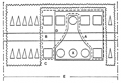
Fig. 12.
Ogawa-mura kinjogumi. X = central household; A = ryodonari muko; B = sashiba;
C = ogumi; D = kumiai; E = bangumi. (Adapted from KK 1983, 138)
and right, and the three households across (usually a thoroughfare) from them.[15]
B. The sashiba, two three-household clusters on either side of the ryodonari muko unit.
C. The ogumi, which encompasses within a single bangumi those households not incorporated into either A or B. The term ogumi first appears in a 1708 document, which may suggest indirectly that A was present at that time or that C preceded A as the primary unit of neighborhood organization.
The "fluid" category of neighborhood division was the basis for the organization and execution of ceremonial activities, particularly weddings and funerals. This is so to a limited extent in the Ogawa Eight today. The ryodonari muko were and remain especially important and operative on such occasions. Several Ogawa Eight natives believe that postwar social and politicoeconomic changes, together with the recent proliferation of commercial wedding halls, have reduced the ceremonial function of these neighborhood units.
The "fixed" category of neighborhood division includes the following:
D. The kumiai, or cooperative group, which encompasses eight households.[16] The cooperative group includes households on both sides of Oume Road, whereas the goningumi was limited to clusters of five households on either the north or the south side of that thoroughfare.
E. The eight bangumi, discussed earlier in reference to the tax division.
The "fixed" category of neighborhood divisions was the basis for the administrative, as opposed to ceremonial, organization of Ogawa-mura, although parish-related activities today are organized on a bangumi basis.
All of these fluid and fixed divisions were created by either the village head or the bakufu within a half-century or so after the initial reclamation of Ogawa-mura. By the eighteenth century, Ogawa-mura was a complex weave of interhousehold ties that bound households to both the village and the bakufu. These same neighborhood divisions, moreover, are operative in Ogawa-cho today. A review of several key morphological features of the kinjogumi system concludes the discussion on kumi.
First is its striking linear arrangement. The diapered ryodonari muko network was absent in Kishi-mura, very likely because of that village's cluster formation. Also, the preponderance of mutual strangers in the nascent Ogawa-mura meant that parishes and other place-linked units, such as the kumi thus far described, either took the place of or took precedence over "blood" and/or fictive kin ties as the basis of villagemaking. With the exception of the village head and clergy—both of whom were exempt from the tax, five-household, and neighborhood divisions—Ogawa-mura settlers were incorporated into a system of interlocking geographic units.
That the clergy constituted another order of villager entirely is illustrated by the following anecdote. On the occasion of our first interview, Miyazaki H., the chief priest of Shinmei-gu, insisted that Ogawa-mura originally was settled by "same-name groups" (shizoku ) and therefore was a "clannish" village. Although this may have been an accurate portrayal of the Miyazakis, as privileged Shinto clergy, it is not an accurate portrayal of the shinden' s initial residents. Since the vast majority of
settlers hailed from rather distant villages, ties between them and their relatives "back home" were attenuated, if not severed altogether. Only the Ogawas are acknowledged in the local literature as having maintained close relations with their Kishi line ever since the reclamation period (KC 1959, 900).
Much of the tenacity of the natives' society in Kodaira today, however, has to do with the gradual metamorphosis of the original placelinks into a network of kindred (shinrui ) relations as the original settler households established branches, which in turn produced branches. The operation of this network of main and branch households is especially evident in the yard shrine oblations discussed in the next chapter. Finally, the present-day descendants of both elite and ordinary settlers have in common a "nativeness" that now transcends historical status inequities and has been reified as a type of primordial solidarity.
Making Ogawa-shinden
Ogawa-shinden, reclaimed in 1725, is a representative example of a village-initiated shinden; that is, a shinden reclaimed by the residents of one village, who each contributed capital and labor. (For a discussion of other shinden typologies, see the Appendix.) Ogawa-shinden essentially was a nomenclatural extension of Ogawa-mura, established as it was on land originally granted to Kurobei as part of his shinden package. This land had remained untouched until 1725, twenty-three years after the first petition to reclaim the eastern segment was submitted. The rationale for the new shinden project was to increase the amount of arable land, since, as the Ogawa-mura head wrote in his petition to the bakufu, population was outgrowing productivity (KC 1959, 116). Permission was denied, and denied again in 1708, for the reason that reclamation work would deplete natural fertilizer resources and hamper the cultivation of existing fields. By the 1720s, however, the tax-minded bakufu once more was encouraging land reclamation, and the conditions proposed by the Ogawa-mura head in 1722 doubtless facilitated matters.
The village head agreed to complete the reclamation of about 700 hectares within three years, and acquiesced to an annual auxiliary tax of twenty ryo, although the annual tax proper was to be suspended for three years. Permission to reclaim 237 hectares was granted midway
through 1724. About 60 hectares, called the detached-land portion (mochizoebun ), were divided equally among the Ogawa-mura households. This worked out to about .33 hectare for each of the approximately 195 households. The remainder, referred to as the independent portion (dokuritsubun ), was sold to several types of buyers: those villagers who wished to establish a branch household on the new shinden; those among the more affluent who wished to increase their landholdings; and those who immigrated from other villages. The holders of independent portions represent the Ogawa-shinden settlers proper. They numbered eleven by 1726, seventeen by 1727, and seventy-one by 1730 (KC 1959, 115-19). However, those villagers for whom an independent portion was an investment tended not to resettle but, rather, contracted their portion to caretakers (yamori ), who comprised a low-status group of settlers. As extant contracts reveal, all of the contracts were issued for a maximum of five years, but the terms of the contracted labor varied (KC 1959, 125). During the period 1720–1730, caretakers were the subject of much new legislation, indicating the prevalence of the caretaker system by that time, perhaps in connection with shinden reclamation (Futagawa 1980, 279).
Within five years of the new shinden' s establishment, about 85 (of the approximately 195) Ogawa-mura householders had sold their shinden shares to other villagers and/or outsiders (KC 1959, 118-19). Unlike Ogawa-mura' s, the population of Ogawa-shinden rapidly became a heterogeneous mix of immigrants. Like Ogawa-mura settlers, however, farmers in the new shinden were immigrants from northern and western areas, as indicated by their "certificates of identity," which are included among the Ogawa household documents. The majority were younger sons and their wives and, in some cases, children.
As was typical of village-initiated reclamation, the new shinden remained under the administrative control of its parent village, Ogawa-mura, until approximately 1740. At this time Yaichi, the head of Ogawa-mura, turned the position over to his son and established a branch household on the nascent shinden, just as Kurobei had done nearly a century earlier. Prior to that time, the headship of both Ogawa-mura and Ogawa-shinden had been served concurrently by Yaichi. For the Ogawas, shinden village-making apparently was tantamount to the process of inkyo-bunke, or the establishment of a branch household upon the retirement of the househead. Other Ogawa-mura households also tended to combine shinden settlement with the formation of inkyobunke (Katayama 1959, 268), implying a correspondence between the
contiguity and continuity of settler households and the process of shinden village-making.
Yaichi's move to the shinden took place after the 1736 cadastral survey, which suggests that by that time the shinden was sufficiently stable to warrant having its own leadership. However, Ogawa-shinden remained under the administration of parent-village leaders. Not only did Yaichi serve in the supervisory post of elder (toshiyori ) in Ogawa-mura, but the annual tax (i.e., the detached-land portion) was collected by the parent village (Kimura and Ito 1972, 79; KC 1959, 122).
Ogawa-mura was a parent village in a way that Kishi-mura had never been, even though the Kyodo Kodaira (Local Kodaira) refers to Kishi-mura, Ogawa-mura, and Ogawa-shinden as "grandparent, parent, and grandchild" villages, respectively—familistic allusions that pertain only to the Ogawas (Kyodo Kodaira henshu iinkai [1967] 1983, 53). Whereas Ogawa Kurobei had initiated and funded the reclamation of a shinden village, which he then named after himself, Ogawa-shinden, although named after the parent village, was initiated and partly funded by Ogawa-mura villagers.
The bakufu encouraged immigration to Ogawa-shinden by offering subsidies for housing (two ryo, two mon in gold). It also granted, as funds for agricultural implements, a reward of 624 mon for every ten ares reclaimed (KC 1959, 100). However, the entire shinden —even the unreclaimed sections—was declared taxable, for the taxation rate was based upon a projected reclamation schedule. Settlers thereby were compelled to reclaim land in order to meet their taxes (ibid., 102). In Ogawa-mura the settlers had protested the autocratic antics of Kurobei; in Ogawa-shinden the primary target of disgruntled immigrants was the exploitative bakufu (ibid., 109).
Conclusion: Ogawa-mura and Kodaira Nativism
Today the Ogawa Eight are imagined by natives and newcomers alike as the historical and authenticating core of Furusato Kodaira. Local media—including the "Kodaira Song," "Kodaira Citizens' Festival Song," "Kodaira Ondo, " and the "local-place playing cards" (kyodo karuta ) sold at city hall—follow the local-history texts in eulogizing Kurobei and Ogawa-mura. Kurobei represents the subjec-
tive human agent and personifies the sociohistorical process of village-making. Eulogized as the civic ancestor of all Kodaira residents, Pioneer Kurobei is presented by local historians and city administrators alike as an exemplar for residents to emulate in the quest to reclaim a "new furusato. " Their point is that furusato-zukuri ultimately is a crescive process calling for local, self-initiated action. Likewise, the citizens' festival, conceived as a populist expression of "old village"-making, is promoted by its planners as a "spontaneous event." Kurobei, the name, has become a Kodaira-specific metaphor for "a process in which communities were more nearly the products of personal and human nature than the contrivances of planners, bureaucracies, and depersonalized institutions" (Suttles 1972, 9).
The irony, of course, is that Kurobei was an autocrat and that furusato-zukuri was initiated by city hall. Nevertheless, the paternalistic style of Kurobei and the Ogawa household has been evoked to spice up Kodaira history. Even the Ogawas' wholly autocratic practice of exacting tribute from the villagers is dramatized unproblematically in local-history texts, as the following example illustrates. Until the amalgamation of Kodaira-mura in 1889, New Year's Day in Ogawa-mura was a time for villagers to pay tribute to the village head. Early in the morning, villagers appeared at the Ogawa entranceway with a New Year's gift of sacks of rice, millet, and wheat. A division leader was assigned to record the gifts and the names of their donors. Later, the head, outfitted in ceremonial garb, was paraded along Oume Road in a palanquin. As his entourage passed by, the villagers lining either side of the thoroughfare were obliged to kneel, bow their heads, and call out the auspicious greeting "omedeto gozaimasu" (Ito 1961, 46–47).
Ogawa-mura is the only shinden of the Kodaira Seven whose founder and founding have been commemorated on a citywide basis. In view of its historical primacy and geographic scope alone, the civic favoritism accorded Ogawa-mura is not altogether surprising. The village was founded about seventy-five years before the others were reclaimed, although in the mid-seventeenth century the Suzukis had attempted to reclaim land in the eastern and southern sectors of Kodaira. Their failure only underscores the alleged engineering genius of Kurobei, thereby enhancing the mythic aura about Ogawa-mura.
Geographically, the former Ogawa-mura monopolizes the eastern half of Kodaira and, with the former Ogawa-shinden, constitutes nearly half of the entire city. Moreover, the eight Ogawa bangumi remain intact as administrative and social units, and they are further integrated by
virtue of their encirclement by the Ogawa branch canal. That the canal remains functional owes much to the efforts of Kodaira natives to preserve it and other branch canals for posterity and as a rainwater runoff. In 1981 city hall, with the cooperation of the agricultural cooperative, declared the last two Tuesdays of May "Clean the City's Branch Canals Day" (KSH, 20 May 1981). Mobilizing the nonfarming newcomer population to clean the canals purportedly sensitizes them to the historical presence and boundaries of the native sector.[17]
Newcomers are also brought into closer contact with the natives' society through the activities of the Kodaira Association for Tourist Agriculture, founded by about fifty farm households in 1979, and also through the "home vegetable garden" (katei saien ) program inaugurated by city hall in 1983. The association seeks to secure a stable local market and expose newcomers to "agricultural culture." Farmers grow only those vegetables—cucumber, Japanese radish, Chinese cabbage, eggplant, carrots, lettuce, green pepper, leek, burdock—ordered in advance by consumers, who then collect their custom-grown produce at harvest time. The association also sponsors "pear-apple" (nashi )-picking, sweet potato—digging, and chestnut-gathering events every fall. These events are promoted as "a way of bringing Kodaira's nonfarming population [i.e., newcomers] closer to the soil" and introducing them to "the joys of toiling and sweating and chatting with [their] neighbors" (KSH, 20 June 1979, 20 June 1984).
A poll conducted in 1984 by the city hall's Public Relations Department showed that 21 percent of the residents have made use of the home gardens and that 58 percent have purchased produce, eggs, and/or plants directly from farm householders (KSH, 5 May 1984). Finally, the annual agricultural fair, cosponsored by the agricultural cooperative and city hall and first held in 1977, is billed as a means of introducing to newcomers "the actual conditions of inner-city farming and husbandry" and "cultivating harmony" between the city's farming and nonfarming sectors (KSH, 5 October 1983).
What are the contemporary circumstances and situation of Kodaira's natives? A key factor contributing to the civic favoritism accorded Ogawa natives today is the sociogeographic integrity of the Ogawa Eight despite potentially divisive developments. A brief review of twentieth-century landholding patterns in the former Ogawa-mura adds more texture to the portrait of the Ogawa Eight today (1985) and in the Edo period.
This area began to undergo unprecedented internal changes begin-
ning in the 1920s. In 1923 about 200 hectares of dry-field and forested land in the southern reaches of Ogawa-mura and Ogawa-shinden were sold to the Hakone Realty Company. There were approximately 115 farm households in the Ogawa Eight at that time, and about 23 in Ogawa-shinden, as compared to about 225 and 88, respectively, in 1857–58. In the immediate postwar period, the same company was also responsible for developing Kodaira Gakuen (now Gakuen Higashicho ) in the mold of the German "academy town" (KC 1959, 205-7, 398, 402, 430, 436, 557). The overall decline in the number of farm households is attributed to several factors, two of the major ones being the Matsukata deflation of the 1880s and the advent of land developers, such as the Hakone Realty Company. Named after the finance minister at the time, the Matsukata taxation and deflationary policies, while beneficial to the government, had an adverse effect on farmers. Crop and food prices went down, but the land tax remained the same, forcing farmers to double the percentage of agricultural production for tax payments (Hane 1986, 100).
During the period 1946–1963, about 1,185 hectares of arable land were sold, the majority of which were converted to residential property. Since then, there has been a decline in the number of households owning 2 or more hectares and an increase in those holding from between 50 ares to 1.5 hectares. The turnover peaked from the late 1950s through the early 1960s, as did the postwar population growth, which ballooned from a total of 15,595 residents (1,895 households) in 1944, to 32,520 (5,967) in 1957, and 72,156 (22,944) in 1963. The population has stabilized since 1985 at around 153,000 persons (about 57,000 households) (KC 1959, 430; KCH, 5 July 1961; KSH, 5 December 1965, 1 January 1985; Kodaira-shi somubu shomuka 1983, 11).
The Kodaira Seven apparently had none of the large-scale absentee landlords typical of paddy-farming villages, although the presence of a "landlord-tenant system" was clearly evident by the 1870s, as revealed by land registers (tochi daicho ) compiled at that time. There were no absentee landlords at all in Ogawa-mura and Ogawa-shinden (KC 1959, 547). The Ogawa Eight were exceptional because, unlike the turn-of-the-century situation in the other Kodaira shinden, most of the land sales or exchanges occurred among resident (as opposed to outside) investors. In other words, although land changed hands—and farm households folded—it did so among residents of the Ogawa
Eight, effectively maintaining the sociogeographic integrity of the area (KC 1959, 440).
In 1928 farm households comprised 83 percent of the population, or 807 of a total 971 households; and 43.5 percent Kodaira (about 1,226 of a total 2,815 hectares) comprised cultivated land in 1929. By the 1950s these percentages had decreased to 18.5 percent, or 1,020 of 5,517 households, and to 32 percent (898 hectares). The increase of 213 farm households in the early 1950s, even though the number of farm households in the total Japanese population decreased drastically, can be attributed to the sale of farmland to postwar immigrants who were obliged to farm as part of a central-government-engineered effort to replenish the food supply in the decade following World War II. Recent (1984) statistics show that 12.5 percent (353 hectares) of Kodaira is devoted to agriculture and that farm households comprise 1 percent of the population, or 577 of approximately 57,000 households (KC 1959, 468, 560; KK 1983, 205, 224; KSH, 1 January 1985).[18]
Prior to the 1946 land reforms initiated by the United States government, 43–49 percent of the total arable land in Kodaira was tenanted, although—in the former Ogawa-mura especially—the tenanted land was owned by resident landlords. By 1955 the average rate of tenancy had fallen to 6.7 percent, nearly 2 percent lower than the national average. The number of owner-cultivators, in contrast, rose from 23 percent prior to the land reform to about 70 percent in 1955 (KC 1959, 589, 591, 596). The consequences of the land reforms were reported in a 1949 survey. According to that survey, 26.5 percent (or 265) of the 998 farm households at the time had their landholdings increased (59 percent by thirty ares or less, and only 2.6 percent by one hectare or more); 14.5 percent (145) had their holdings reduced (73 percent by thirty ares or less, and 2.1 percent by one hectare or more); and 59 percent (588) neither gained nor lost land. The relatively uneventful land reform is attributed to the fact that the largest landholdings in Kodaira amounted to less than thirty hectares, far less than the one thousand hectares owned by some paddy landlords in Niigata and Yamagata prefectures (KK 1983, 216-17).
The Ogawa Eight presently boasts the largest concentration of farmers in Kodaira, as well as the distinction of having retained its shinden -village configuration, although almost all of the thatched-roof houses have been replaced by concrete ones. In 1958–59, for example, about 50 percent of the households in the Ogawa Eight declared agri-
| ||||||||||||||||||||||||||||||||
culture their livelihood. This is more than twice the citywide average for 1955, in which 19 percent of the working population was engaged in agriculture, down from 35 percent in 1950 and 79 percent in 1920. Kodaira agriculture as a whole remains an overwhelmingly inner-city occupation. In 1958–59, 98.5 percent of Kodaira farmers worked on local land, in contrast to the 94 percent of office workers (newcomers) who commuted to offices outside Kodaira. These same percentages hold for the 1980s as well.
The Ogawa Eight is unique in possessing the highest concentration of farmers: over 10 percent in 1975, as opposed to 1 percent citywide (table 3). A significant percentage are young, indicating a degree of generational succession and continuity. A survey conducted by city hall in 1978 indicated that 56 percent of the total number of farm householders intended to remain in agriculture for at least another decade, and 35 percent for at least another five years (Kodaira-shi keikaku zaiseibu keikakuka 1980, 72). Although statistics are unavailable, these percentages doubtless were and are much higher among Ogawa-cho farm households. The presence of farmers, in turn, facilitates the preservation of both historical institutions, notably shrine and temple parishes, and the vaunted "atmosphere of olden Musashino." Because of its geographic integrity, visual antiquity, and large concentration of
farmers, the Ogawa Eight constitutes the most intact sector of the natives' society.
In this chapter, I have traced the progress of Kodaira from the making of Ogawa-mura to the circumstances of the native sector today, and specifically the Ogawa Eight. Present efforts to unite the native and newcomer sectors through such productions as the citizens' festival and "tourist agriculture" amount to affective city-planning strategies. However, in seeking to instill in newcomers a sense of belonging and commitment to Kodaira, city hall also has spurred an increasingly palpable microlocal patriotism on the part of natives, epitomized by the Ogawa Eight. The paradox here is that the consciousness among both natives and newcomers of having Kodaira residency in common has had the effect of putting a special emphasis on that which differentiates them (Erickson 1980, 101). How differences between natives and newcomers are constructed, perceived, and deployed by each sector informs the following chapters.