5—
Santa Margarita River South through Oceanside and Carlsbad
Description of the Area
The terraces of the Camp Pendleton area terminate with the entrance of the San Luis Rey and Santa Margarita rivers which come to the coast just north of Oceanside. The City of Oceanside is built on the low terrace margin of Pleistocene nonmarine origin which extends on into Carlsbad and is about 30 feet above sea level (fig. 19). During the late 1880s the beach off Oceanside was approximately 300 feet wide (USCGS 1889b ). In former times this beach, which was practically unbroken from San Diego to Los Angeles, was used as part of a highway for horse-driven vehicles. The cliffs above the beach were retreating during the wet years of the 1880s as the result of subaerial erosion (fig. 20).
Works of Man
In 1888 a supply wharf extending approximately 1,080 feet into the water was built, and with it the first coastal construction began. This wharf, however, was destroyed by rough surf two years later. Nevertheless, local interests rebuilt the wharf, and it was altered and improved several times in the course of the next thirty years without detrimental effect to beach processes (Hales 1978). In 1927, a 1,132-foot open-pile recreational pier was constructed by the city of Oceanside at the foot of Third Street, just north of where the former wharf had been destroyed. The new pier has been severely damaged many times, during periods when depletion of the beach sand berm coincided with large storm swells and high tides. Some 200 feet of the pier collapsed in March 1978 during a perigean spring tide, and in 1983 another large section was destroyed.
In 1922 Lake Henshaw, the largest reservoir in San Diego County, was completed. The structure reduced the sediment-carrying capacity of the San Luis Rey River and thereby diminished the natural supply of beach material to Oceanside beaches. By 1925 the usable beach was quite narrow, and the beach width could be correlated with the stream runoff rate from the river (Hales 1978). The last storm-flood year to contribute appreciable amounts of sediment to southern California beaches was 1938 (Troxell et al. 1942). Following the floods the beaches were considerably widened, and the tourist trade flourished at Oceanside.
From 23 December 1940 through 7 January 1941, a series of storms originating in the Aleutian Islands moved into southern California and considerably damaged beachfront and bluff-top property (Kuhn and Shepard 1979a ). Houses in Oceanside were damaged or destroyed (fig. 21), and the beach berm was severely eroded elsewhere. A thirty-foot swell running along the coast coincided with gale-force winds and the perigean spring tide. Near Wisconsin Street in Oceanside, Sereno Court was damaged. The San Diego Union (27 December 1940) noted:
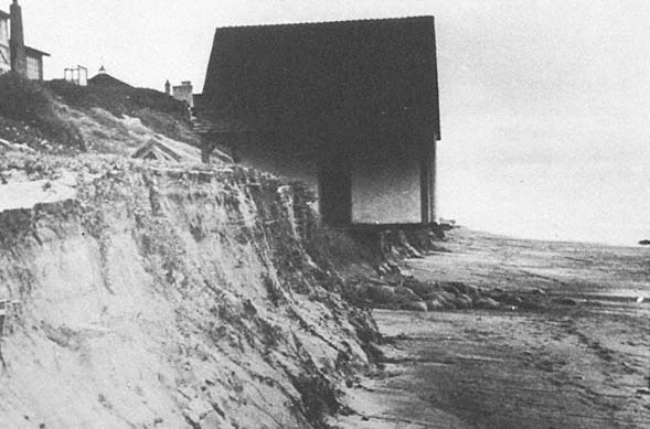
Figure 21
January 1941 beach erosion initiated by a severe storm.
Photo : D. L. Inman.
High tides and a pounding sea continued to damage the Oceanside shoreline. Combers broke over the end of the pier at high tide today. A crew of men worked all day yesterday and today to save El Sereno Court from being swept out to sea. Sandbags have been piled high against the buildings. The Arthur Neff home, which has been protected by a retaining wall, has received a severe buffeting from the sea. Foundations of the Guy Sensaba home are menaced. Precautions were taken today to hold back the sea.
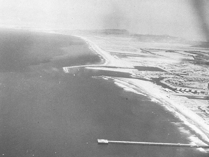
Figure 22
Aerial view looking north across Oceanside toward the Camp Pendleton Boat Basin and the Oceanside Harbor, 1974. Note that
the width of the beach decreases south of the harbor.
Photo : G. Kuhn.
Harbor Construction:
At Camp Pendleton and North of Oceanside
In 1942, under emergency wartime conditions, Camp Joseph Pendleton was created by the federal government with the purchase of Rancho Santa Margarita y Los Flores, immediately adjacent to the northern limits of Oceanside. In conjunction with the establishment of a Marine Corps camp, the federal government built a jetty and boat basin on the beach, just north of the city limits, in order to provide Camp Pendleton with a harbor facility and boat-turning basin.
The harbor began silting up immediately after the jetties were constructed, and much of the sediment which had been carried south to preserve the wide beaches of Oceanside was lost, necessitating continual dredging of the harbor and pumping the spoils to the south to replace the lost material (Inman 1976) (fig. 22). Despite clear evidence that jetties for the boat basin north of Oceanside would cause difficulties for the wide beach off Oceanside, pressure was applied, and in the early 1960s a small boat harbor was constructed south of the ill-fated turning basin at Camp Pendleton. In March 1960, Marine Advisors (1960) made a study for the U. S. Army Corps of Engineers relating to the size of storm waves that would be likely to hit the small-craft harbor site. They showed that waves of over twenty-five feet were recorded at Oceanside during the tropical storm of 23–25 September 1939. In spite of the danger of such storms, the harbor was authorized. In 1963, four million cubic yards of material were dredged to construct the Oceanside small-craft harbor and deposited on what were then the downcoast beaches. This dredge spoil material contained many cobbles, derived from floods of the San Luis Rey River (Hales 1978:20). Approximately ten million cubic yards of sediment, including cobbles, have been dredged from the Camp Pendleton Basin and Oceanside Harbor between 1942 and 1980 (Shaw 1980). Despite this large fill, erosion began almost immediately. In 1965, cobbles made their first appearance on the beach in front of Oceanside, as the beaches eroded.
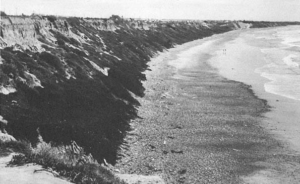
Figure 23a
April 1981 view from the Palomar Airport Road looking south along the beach.
Photo : G. Kuhn.
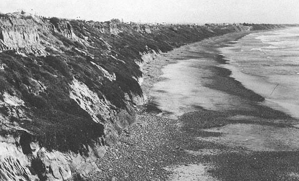
Figure 23b
February 1983 view from the same vantage point as that in 23 a . Note the extensive cliff erosion.
Photo : G. Kuhn.
Cobble Beaches
In southern California beach cobbles are derived from two sources: from rivers as the result of floods, and from sea cliff erosion (Emery 1955). The longest cobble beach in southern California is found in south Carlsbad (Emery 1960:184) (fig. 23a ). During the storms of January 1983, the beach cliff eroded six to ten feet in places (fig. 23b ). In 1960, Emery noted that the cobbles of this beach, which is presently owned by the State of California, were the result of local cliff erosion. Today, however, the cobbles are much larger and were most likely dredged from the Oceanside small-boat harbor to the north, as early as 1963.
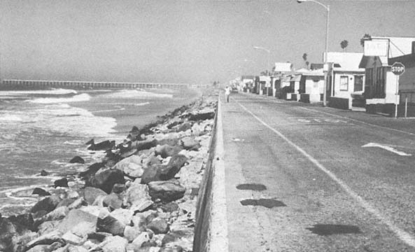
Figure 24a
September 1979 view looking north along The Strand at Oceanside. The structure and road were located on the
former beach. Riprap was placed to protect the concrete seawall and road.
Photo : G. Kuhn.
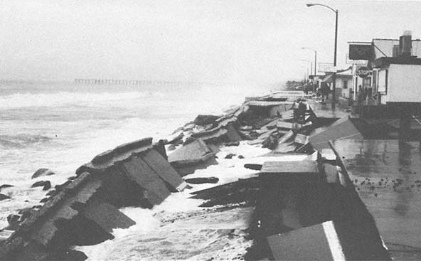
Figure 24b
February 1980 view looking at the same site as that in 24 a . The road and seawall were undermined and collapsed
between 12 and 15 February 1980; the waves were less than six feet high.
Photo : G. Kuhn.
During the storms of 1978 from the south, the beach sand was rapidly removed by storm surge, and the cobbles were withdrawn by the waves and thrown like artillery against houses at Oceanside (Kuhn and Shepard 1980). The cobbles became a destructive element again in the winter of 1980, contributing to the undermining and collapse of the beach road (figs. 24a , 24b ) and to the damage to apartments and homes along the shore (figs. 25a , 25b ). In south Oceanside, roofs collapsed and windows were broken as the cobbles again became projectiles (fig. 26), although the waves were consistently less than six feet in height. Even where riprap protected the shore, the cobbles moved as far as twenty feet up the beach (fig. 27a ). The stones were seen to move along the shore and by June 1978 had largely disappeared (fig. 27b ).
The Army Corps of Engineers (Hales 1978:27–32) suggested several alternatives for stabilizing the sand and creating a buffering beach at Oceanside. These included rock revetments, concrete seawalls, groin systems, sand-fills, breakwaters, and a permanent sand bypass system. At the present time sand-fills are the only method being attempted.
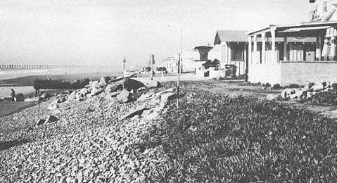
Figure 25a
View of beach cottages south of Wisconsin Street in Oceanside, 4 January 1978.
Photo : G. Kuhn.
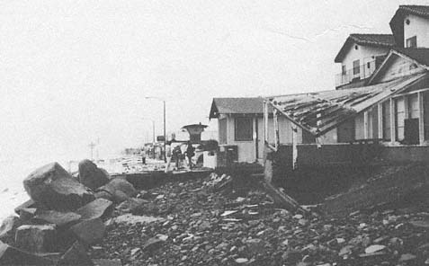
Figure 25b
View at the same site as that in 25 a , taken 17 February 1980. Wave and beach cobble
abrasion damaged houses along the shore during the February storms. Property damage
occurred as the result of cobbles being thrown by waves less than six feet in height.
Photo : G. Kuhn.
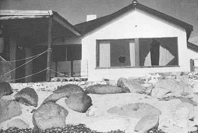
Figure 26
February 1980 view of the damaged beach cottage in south Oceanside.
Note that the windows were shattered and the roof collapsed as a result
of cobbles being thrown by relatively small waves.
Photo : G. Kuhn.
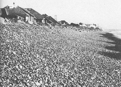
Figure 27a
January 1978 photo of beach cobble abrasion in south Oceanside. Cobbles
moved up the beach eighteen to twenty feet, covered the riprap seawall in
places, and eroded lawns behind the seawall.
Photo : G. Kuhn.
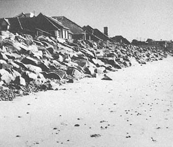
Figure 27b
June 1978 view at the same site as that in 27 a . Only remnant
pockets of cobbles remain.
Photo : G. Kuhn.
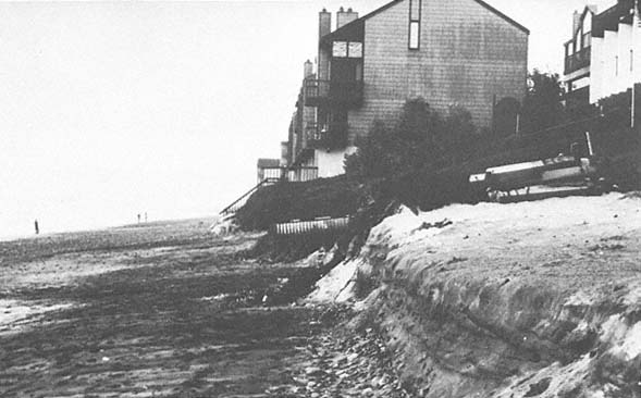
Figure 28a
April 1978 view of eroding beach at Carlsbad.
Photo : G. Kuhn.
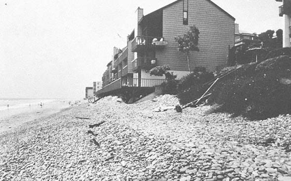
Figure 28b
July 1980 view of the same site in Carlsbad. The sand did not return to the beach this year during the summer.
The cobbles have eroded behind and around the seawalls and the riprap and adjacent to the building.
Photo : G. Kuhn.
Failure of Sand to Return to Beaches During Summer 1980
Beach processes monitored prior to 1978 indicated that sand levels drop during the winter (fig. 28a ) and return again approximately to their usual level in the summer. In the summer of 1980, however, the sand did not return to its usual level along the Oceanside-Carlsbad area (fig. 28b ). As noted previously the longshore currents changed after 1980 at Oceanside (Seymore 1980–1982). An additional factor may be that the Carlsbad Submarine Canyon to the south intercepted the sand offshore.
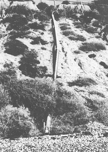
Figure 29a
December 1977 view of the storm drain designed to carry surface water
down and away from the slope face at Carlsbad State Park.
Photo : G. Kuhn.
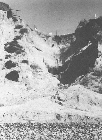
Figure 29b
February 1979 view at the same site as that in 29 a , following the
collapse of the drain pipe, which caused severe erosion of
the bluff face.
Photo : G. Kuhn.
Many cliffs in the area are actively retreating today, not in response to wave action, but primarily because of solution by groundwater and the fact that man has installed storm drains on the bluffs, which were designed to divert surface water away from the bluff face (fig. 29a ). However, in 1978, 1980, and again in 1983, many of these drains collapsed, and escaping water severely eroded the bluff face (fig. 29b ).
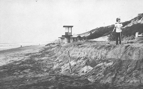
Figure 30a
January 1978 view looking north along Carlsbad beach.
Photo : G. Kuhn.
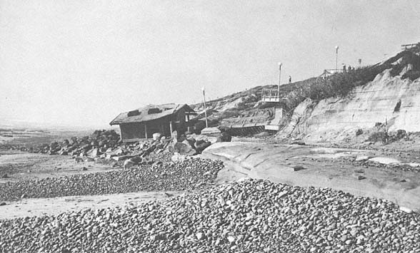
Figure 30b
February 1983 view at the same site as that in 30 a . The lifeguard tower is gone, the restroom and the stairway
have buckled and collapsed, and the cliff has retreated fifteen to twenty feet.
Photo : G. Kuhn.
If the formerly predominant southern transport of sand is not restored, it is difficult to estimate what will happen to the large quantities of sediment found off portions of the inner shelf south of the San Dieguito River (Fischer et al. 1981). At any rate, the beaches from Leucadia south to La Jolla grew during February 1982. An explanation is elusive at this point, but it may have something to do with the change of the longshore current direction. Erosion of the beaches and cliff retreat accelerated during the stormy months in early 1983. At Carlsbad Beach, where concrete restroom facilities and lifeguard towers were built directly on the beach prior to the 1978 storms (fig. 30a ), in 1983 two concrete restrooms were undermined and bombarded by cobbles and small riprap, and eventually collapsed and subsequently were removed. The adjacent cliff retreated by as much as fifteen to twenty feet during one storm (fig. 30b ). The coast highway near the Carlsbad Encino Power Plant was severely damaged and collapsed in places during this storm. Most of this very rapid erosion occurred during the storms of late January and early February 1983, which coincided with the perigean spring tide, a ten- to twelve-foot swell coupled with extremely strong winds.
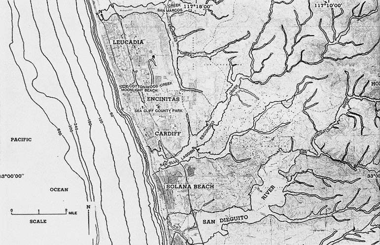
Figure 31
Location map of Leucadia, Encinitas, Cardiff-by-the-Sea, and Solana Beach.