1
The Kundagai
Environment and Society
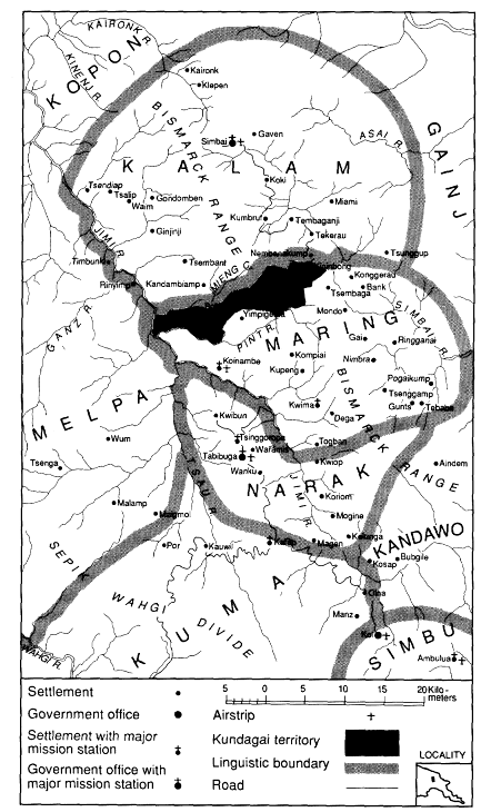
The Western Bismarck and Schrader Mountains form the last bastion of the central highlands before the land falls away to the humid lowlands of the Ramu floodplain. Several cultural groups inhabit these northern fringes: the Maring, Narak, and Kandawo whose affinities are close to Wahgi Valley central highlanders, and the Kopon, Kalam, and Gainj comprising a language family only distantly related to the main highlands stock (see map 1).
Like their fellow highlanders the Maring are swidden agriculturalists and pig-raisers. The staple diet is provided by sweet potato and taro, but a great variety of other crops is grown. Some have always been present, others have been introduced from their neighbors over the last hundred years or more. The list includes yams, cassava, bananas, sugar cane, pitpit, corn, and cucurbits, besides numerous leafy greens and tree crops, notably the fruit pandanus and breadfruit. In addition to pigs, which are seldom eaten outside of irregular ritual and ceremonial occasions, the Maring keep a few fowls, dogs, and cassowaries. Many local groups enjoy a higher intake of meat than one might otherwise suppose, however, for game is plentiful in some areas. Nonetheless, exploitation of wild resources is not solely geared toward satisfying gustatory desires, for the forests abound in a great variety of birds and mammals whose feathers and pelts are eagerly sought by those less favorably endowed.
The Kundagai are one such community who engage in considerable
Map 1.
Jimi Valley
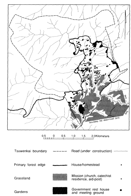
hunting to supply trade goods. They are one of more than twenty Maring local populations and occupy a large territory stretching between the Jimi and Simbai Rivers. They live in three settlements: Bokapai and Tsuwenkai in the Jimi Valley, and Kinimbong in the Simbai. I am concerned mainly with the people of Tsuwenkai (map 2), and unless stated otherwise I mean the name Kundagai to refer to that section of the population living there.
This chapter describes the environmental and ethnographic context for the subsequent account of hunting and trade. I begin with attention to aspects of the natural environment, with some general notes on the impact of human occupation. There follows an account of critical aspects of Kundagai social organization. I conclude with a summary of settlement history with particular attention to land tenure.
The Physical Enviroment
The government rest house of Tsuwenkai lies at about 5º25' S, 144º38' E, at an altitude of 1,680 meters. The settlement is in the headwaters of the Pint River, a tributary of the Jimi. The Jimi Valley comprises the Tabibuga District of the Western Highlands Province and is administered from Tabibuga on the Tsau-Jimi Divide. Until the early 1970s, when a road suitable for four-wheel drive vehicles was completed from Tabibuga to Banz in the Wahgi Valley, the only means of contact within and beyond the Jimi was by walking tracks or light aircraft. By the mid-1980s the Kundagai and others had invested around twenty years' of manual labor into building a road connecting settlements on the north bank of the Jimi to Tabibuga. Although the Jimi River was bridged in 1978, the road was still not passable in 1985 to traffic beyond a few kilometers from the bridgehead. Long, well-graded, but unconnected sections of road were continually reclaimed by secondary growth or swept away in landslides. The labor involved in roadbuilding and maintenance was compounded by repeated rerouting of extensive sections of the road.
The north wall of the Jimi Valley is formed by a western extension of the Bismarck Range. The valley is separated from the densely populated Wahgi Valley to the south by the Sepik-Wahgi Divide that rises to over 3,700 meters in places. These two ranges converge in jagged, cloud-piled ridges on the central massif of Mount Wilhelm. On clear days this highest peak in Papua New Guinea is visible from Tsuwenkai some 60 kilometers to the southeast, rendered a mere hummock by the
Map 2.
Tsuwenkai Vegetation and Settlement
closer, more dramatic ranges. The Jimi is a turbulent, rock-strewn river that rises on the snow-fed slopes of Mount Wilhelm and plunges down its narrow, cliff-hung bed on its way to the Sepik River to the northwest. To the north of the Bismarck Range the Simbai River flows eastward and then north to join the Ramu River.
I made no detailed records of climate during fieldwork other than noting temperatures for 204 days over 12 months in 1973-1974. Clarke (1971: 39-50) and Rappaport (1968: 32-33) give details of rainfall at Gunts, Tsembaga, and Simbai Patrol Post in the Simbai, and at Tabibuga in the Jimi. On comparative grounds the annual rainfall at Tsuwenkai is probably between 3,000 and 4,000 millimeters.
During the wetter season, about November to April, rain falls almost every afternoon, and mountain peaks are often obscured by cloud for much of the day. In the late afternoon heavy banks of cloud well up in the Simbai to spill over into the Jimi, and the evening is often enlivened by the ominous roll of distant thunder and the flicker of lightning from the Ramu lowlands. The dank and miserable reputation those regions enjoyed among my Kundagai friends seemed well deserved.
In the drier season, May to October, the sky is often cloudless and no rain may fall for periods of up to a week. Occasionally the dry season does not become properly established, or is shorter than usual, and so hampers garden preparations as gardeners wait for fine weather. Under these circumstances a gardener may be unable to clear as much land as desired or to achieve an adequate burn of trash. Such times create anxiety over food shortages, although the Kundagai mainly suffer hunger for favored crops rather than any serious absolute shortage of food. Heavy afternoon rains sometimes cause minor flooding of streams, small landslides beside tracks, some sheet erosion in gardens with sparse vegetation cover, and damage to sugar crops flattened in the downpour. Although excessive rain periodically causes problems, the Jimi does not appear to be significantly affected by drought, although many smaller streams dry up toward the end of the drier season.
Daily maximum temperatures varied during fieldwork from 16.5º C in June to 29º C in October, averaging 22.8º C. Minima were usually reached around six A.M. and ranged from 11º C to 18º C (both records in November), averaging 14.9º C. I do not know if frosts ever occur; certainly the Jimi was not affected by the devastating frosts in higher
altitudes of the Western and Southern Highlands Provinces of 1972, which occurred while I was in the upper Jimi.
As elsewhere on the highland fringes the landscape is dramatic. The Jimi River flows along the northern part of the valley so that a cross-section of the valley is a lop-sided V shape, with a steep north wall and more gentle southern slopes. Especially on the north side the numerous watercourses are deeply incised, producing a rugged topography. Tsuwenkai itself is situated on the flanks of a range on the west of the Kant River, extending southward from the Bismarck crest. The Kant Valley is narrow, with short, steep lateral spurs and intervening streams. The Kant joins the Pint River south of Tsuwenkai. Aside from some tiny marshy patches by the river, there is no flat land in the Kant Valley and only a few gently sloping areas along the upper course of the Pint. Tsuwenkai territory ranges in altitude from about 1,200 meters to at least 2,800 meters in the short space of about six kilometers.
North of Tsuwenkai a low pass, Gendupa, allows fairly easy access across the Bismarcks to the Simbai Valley. A similar pass at Gachambo at the headwaters of the Kant connects with the Mieng drainage system. Another pass north of the Mieng gives access to Kumbruf in the Simbai.
The loose shales and clays of the Tsuwenkai region are prone to landslides, especially after the shallow soils are waterlogged with rain. Small slides are common on embankments beside tracks and gardens. Larger slides of one or more hectares in extent occur in both grasslands and primary forest.
Vegetation and Ecological Zones
The Tsuwenkai region totals about 25 square kilometers, excluding 1 to 1.5 square kilometers of high-altitude forest claimed by the Simbai Valley Tuguma (see below).
On the basis of vegetation and fauna, Tsuwenkai can be viewed as a montane region. The Kundagai of Tsuwenkai are probably the only Maring group to be confined exclusively to the montane zone, although they do have some access to lower areas at Kinimbong in the Simbai. The Tsuwenkai region can be divided into three ecological zones with characteristic vegetation types.
Montane Zone
This zone consists of primary montane forest[1] and extends down from the mountain peaks of over 2,800 meters to the forest edge at
about 1,700-1,850 meters. The Maring call such forest kamungga, apng geni , or apng geni mai . The last two terms refer to virgin forest. Kamungga is often used as a synonym for montane forest but may also refer to secondary growth. The connotations are generally wider than a vegetation type, including high altitudes, a cold and wet climate, and a characteristic fauna. The term, then, refers not only to a vegetation type but to a particular ecological zone.
Clarke (1971:207 ff.) and Rappaport (1968: 271 ff.) give details of the floristic composition of montane forest. Characteristic of this zone are groves of tall Pandanus palms and huge cenda trees (unident.). Above about 2,400 meters are stands of kamai, Nothofagus Beech.[2]
The Kundagai say that in the recent past montane forest extended over most of the Tsuwenkai area right down to the Kant River. Much of this in the lower altitudes was apparently oak forest of Castanopsis and Lithocarpus species. There are small stands of remnant oaks in the Kant Valley.
Montane forest has a more or less continuous canopy about 30 meters or more above the ground. Two, sometimes one, substages are generally present. The ground level is usually fairly clear, though where a dominant tree has fallen or trailing bamboo becomes established the undergrowth can be quite dense. Most trees are heavily laden with moss, especially above about 2,200 meters where trees become somewhat stunted.
The montane zone covers about sixteen square kilometers or 64 percent of the Tsuwenkai area.
Zone of Human Habitation
In Tsuwenkai most of the land below the montane zone falls into this category. This region presents a patchwork pattern of secondary forest in various stages of development, gardens, homesteads, and groves of planted trees. Tracts of anthropogenic grassland are interspersed within this area. The zone owes its origins almost entirely to the presence of humans, having developed where man has cut or burnt the original forest. Because of the diversity of vegetation it is convenient to distinguish several subzones.
Secondary Forest and Woodland . While recounting the oral history of Tsuwenkai, informants often made reference to former vegetation cover. From their remarks it appears that secondary forest transforms into forest classed by the Maring as apng geni mai after forty to seventy
years. [In the lower and wetter Ndwimba Basin of the Simbai regeneration is quicker (Clarke 1971: 61).]
The speed of development of secondary forest and woodland varies from one site to another but, on average, growth reaches a height of about nine meters in ten to fifteen years. The Kundagai attribute such variations to differences in soil fertility and the floristic composition of the fallow growth—no doubt interrelated factors. Moisture content of the soil probably also influences regeneration. Thus, relatively open-spaced communities dominated by the trees Trema orientalis, Dodonaea viscosa , and Alphitonia incana , shading a scrubby understory, tend to form woodlands on drier sites. In wetter areas secondary forest: is denser, supporting a greater variety of plants. Various Piper and Ficus species, and tree ferns, Cyathea , are common on such sites, as well as succulents such as wild ginger, Alpinia spp.
Bush Fallow . Lower growth is generally composed of dense stands of saplings pushing their way through a tangled layer of shrubs and bushes. On damp sites beds of pitpit (Miscanthus cane-grass) are common.
The distributions of secondary forest and woodlands and bush fallow are not differentiated on map 2 but comprise all areas not shown under primary forest, gardens, and grassland.
Homesteads and Plantations . These are areas dominated by vegetation actively induced by human activity. In contrast to gardens they tend to be semipermanent. There are around forty separate homestead or single-house sites scattered along the west flanks of the Kant Valley. Frequently a leveled space must be excavated into a hillside to provide room for a house. Settlement patterns are discussed below; here it need only be said that the Kundagai do not generally form any strong attachments to a particular homestead site, other than of convenience or sentiment. Once a house is beyond repair after two or more years' occupancy, the householder may rebuild nearby or more than a kilometer away. Moves are motivated by various factors: a desire to be close to new gardens, to friends or relatives, or to escape from unpleasant neighbors or sickness and witchcraft associated with a particular location.
Tobacco and bananas are often planted among the hearths and refuse of old house sites, and the yard may be planted extensively with casuarina trees. Once these reach a suitable height, coffee seedlings are
often planted in their shade. In this way old homesteads are transformed into relatively permanently altered areas. Sites that are totally abandoned generally revert to secondary forest, or occasionally to a disclimax of grass.
Groves of bananas, sugar, and green-leaved vegetables are usually planted within a homestead yard, along with shrubs and trees of an ornamental, utilitarian, or magical nature, such as casuarinas, tankets, crotons, bamboos, and various succulents and aromatic herbs.
Most coffee groves are established close to homesteads, in old kitchen gardens. Coffee requires a good shade cover, and casuarinas are favored for this purpose because they grow rapidly, yield superior timber for firewood, building, and fencing, and enrich the soil.
Groves of various other tree crops, especially the marita Pandanus, Pandanus conoideus , are scattered about in secondary growth or in homestead gardens. Few other propagated tree crops are grown in Tsuwenkai as they fare poorly at this altitude.
Included in this subzone are the raku[3] or ceremonial pig-killing groves and ossuaries. There are at least fifteen of these scattered throughout the zone of human habitation. Raku are generally small, less than about 0.2 hectares, although some are on the edge of primary forest or within secondary forest. Many raku are composed of remnant patches of montane forest, others are of secondary growth that has sprung up in the shade of casuarinas, Araucaria pines, and other trees planted by early Kundagai immigrants to Tsuwenkai. Raku are associated with particular clans, and the bones of the dead clansmen were formerly secreted in the ground or in tree hollows and epiphytic plants. Under government and mission influence the dead are now buried in graves, usually outside raku . The spirits of the dead are believed to linger about raku and, although one may gather firewood and creepers or resin from Araucaria pines from a raku , one should not cause undue disturbance lest the spirits visit sickness on the living.
The distribution of homesteads and isolated houses is shown in map 2. I have no estimate of the total area involved, nor of the area of groves of coffee or casuarinas and raku . These latter areas have not been distinguished on the map but are included within the type of vegetation surrounding them.
Secondary forest, bush fallow, homesteads, planted groves, and raku together cover about 6.3 square kilometers or 25.2 percent of the Tsuwenkai area. Spontaneous fallow growth constitutes the larger part of this area.
Gardens . The Maring practice swidden or slash-and-burn agriculture (see Clarke 1971; Manner 1977; Rappaport 1968; 1971, for details of agricultural practices and energetics). Each householder clears two or more gardens a year. Yields can be sustained from a little over one year to two years after planting depending on the crops planted. Sugar, bananas, and pitpit, Saccharum edule , can be harvested for the greatest length of time. The Kundagai generally plant their gardens only once and, although they are weeded periodically, much secondary growth has already sprung up among the crops by the time they are abandoned.
Map 2 shows gardens ranging in age from those just cleared in the dry season of 1974 to gardens about two years old. The total area under cultivation (excluding smaller homestead gardens that are not shown on the map) is less than 0.5 square kilometers. This constitutes no more than 2 percent of the total Tsuwenkai area or 8.3 percent of the area currently under a fallow of secondary forest, woodland, and bush.[4] There is a concentration of gardens on the southern slopes of Komongwai. This area is particularly favored because of the fertility of the soil, in consequence of which crops and fallow develop more rapidly than elsewhere, permitting more intensive cultivation under shorter fallow periods.
Gardens are cut at altitudes ranging from the Kant River (about 1,200 meters at lowest) to the edge of montane forest at about 1,850 meters. In the Simbai Valley, gardens are mainly cut between 900 meters and 1,520 meters, mostly below the lower limit of Tsuwenkai gardens. Rappaport (1968: 52) states that Tsembaga fallow periods are shorter in lower altitudes and, overall, average around fifteen to twenty-five years.
Tsuwenkai gardens do not appear to conform to this pattern, having shorter fallow periods despite higher altitude. Of a sample of twenty-nine gardens in preparation during 1973-1974, one was being cut in primary forest at about 1,720 meters. The remainder were in secondary forest. All these sites had been gardened at least once previously,[5] while one was being planted for the fourth time. According to the Kundagai, fallow periods vary in relation to soil fertility and floristic composition of regrowth, not altitude, although these factors are partially dependent on altitude. The type of crops to be grown also occasions some variation: sweet potato is considered to grow adequately on poorer soils or on land left fallow for shorter periods. The average fallow period for the twenty-eight gardens is fifteen to sixteen years (range six to
twenty-two years, mode twelve years, eight cases). A sample of a further twenty-six newly prepared gardens in 1978 yielded the same average and modal figures (range ten to twenty-six years). In 1985 a sample of thirty-two new gardens indicated a slight lengthening of fallow cycles. Three gardens were being prepared in primary forest; the average fallow period for the remaining twenty-nine gardens was eighteen to nineteen years (range nine to thirty-five years with a bimodal distribution of ten to eleven years, six cases, and sixteen to seventeen years, five cases). This shorter fallow cycle than Simbai regimes may reflect a slightly higher recovery rate of soil fertility. The Kundagai themselves consider Tsuwenkai to be sufficiently fertile, though they compare it unfavorably with lower altitudes in Kinimbong, Koinambe, and Bokapai. Informants were adamant that fallow periods were not limited by a shortage of garden land,[6] and the tendency toward longer fallow cycles and clearing of virgin land in 1985 is indicative of abundant land resources rather than falling productivity.
Grassland
The most extensive grasslands in the Tsuwenkai region are close to its southern boundary. Oral traditions indicate that the larger tracts of grassland from Korapa southward have remained relatively stable in area for about two hundred years, although there may have been some expansion of grassland on Komongwai. Aside from oral traditions the antiquity of these grasslands is further suggested by the component species. Themeda , which grows on older grasslands with poorer soils (Henty 1969: 1), is probably the dominant species in most grassland associations. Kunai grass, Imperata cylindrica , dominates in some widely scattered areas. Grassland covers about 2 to 2.5 square kilometers, or about 9 percent of the total Tsuwenkai area. The largest single area of grassland, on Komongwai, is just over one square kilometer in area.
There is one further vegetational and ecological zone in the middle and lower reaches of the Jimi. This is characterized by primary lower-montane rainforest, termed wora by the Maring to distinguish it as an ecological zone from the kamungga . There is no such forest in Tsuwenkai territory, although it is present in Kundagai lands in Bokapai and Kinimbong. The term wora , however, is sometimes applied to advanced secondary forest near the Kant River to distinguish it from primary high-altitude forest.
Effects of Human Activity on the Environment
As already noted, the zone of human habitation owes its characteristics largely to the activities of man, having developed on sites cleared for gardens. Humans continue, however, to have an influence on the vegetation long after regrowth has reclaimed their gardens. Primary and secondary forest is exploited for a wide range of vegetation used for technological, ritual, or magical purposes. During the productive life of gardens, the Maring practice selective weeding, generally removing weeds and shrubs but sparing tree seedlings (Rappaport 1968). The result of such selectivity almost certainly produces forest somewhat different in composition and conformation from what it might have been if allowed to develop without interference. Foraging domestic pigs also cause some damage to the forest ground cover, uprooting saplings and shrubs up to altitudes of about 2,000 meters on ridges closest to the settlement. Such interference need not be detrimental to the ecosystem. The succession of secondary growth to climax forest is apparently not prevented, though it may be retarded.
The area of secondary growth and gardens is largely the product of about the last seventy years of continuous occupation (see below). There is evidence, however, to suggest that most if not all the stable grasslands in the Pint Basin are disclimax communities growing on former forested land gardened by earlier inhabitants of the region.
Several Kundagai recognized that stable grassland can develop on sites of former human occupation and attributed the extensive grasslands of the Pint Basin to human activity. The role of fire is also recognized in maintaining grassland, and with this in mind the Jimi Local Government Council has drawn up a by-law forbidding the burning of grassland. The Kundagai actively attempt to reclaim grassland for agricultural use by planting casuarinas. The success of this program was evident in the marked reduction in areas of grassland within the settlement between 1978 and 1985.
Pigs are probably also instrumental in maintaining grassland communities. Except on rare occasions feral pigs are unknown in Tsuwenkai. The effects of pigs on the environment are therefore ultimately a consequence of human occupation. By uprooting tussocks in grassland, pigs may also destroy seedlings of other plants colonizing some areas. Pigs can churn up large areas without killing the grasses themselves.
Factors contributing to the maintenance and reclamation of grass-
land probably balance one another, for the total area of grassland in the Pint Basin as a whole does not appear to have changed much in the decade 1959-1969 (Healey 1973: 17).
It is not clear, however, whether the amount of Tsuwenkai forest has decreased over recent years. The population appears to be increasing (see below), and one might therefore expect that more gardens are now being cut. It seems likely, nonetheless, that the amount of Kundagai land under cultivation has actually decreased over the last two decades. In the 1940s the Maring as a whole were reduced by about 25 percent in a severe dysentery epidemic (Buchbinder 1973). Then in 1955 or 1956 the Kundagai suffered another epidemic, probably of influenza, which informants say took a heavy toll of life. Before this epidemic they were more numerous than at present. My genealogical data are insufficiently detailed to test this statement statistically, but they do suggest a higher death rate of young and middle-aged adults for the time of sickness than for other periods. It is quite likely, therefore, that informants' statements are accurate and that the Kundagai do not require as much garden land now as in the past.
Although there has been continuous settlement of Tsuwenkai for the last seventy years, the population fluctuated greatly until about 1955-1956. The largest population up to that date was probably in about 1930-1935 or 1940 when the figure may have approximated the present level. In the mid-1950s a major movement from Kinimbong to Tsuwenkai occurred. Since then the population has remained fairly constant or grown somewhat. In the years preceding the last Kundagai konj kaiko or pig-killing festival in 1960, however, many more gardens than usual were cleared to support the growing pig herd and to provision feasts associated with the ritual cycle. These years probably saw the most extensive clearing of primary and secondary forest for gardens, a conclusion supported by the large amounts of advanced secondary forest in the upper Kant Valley and on the east bank of the Kant, which are said to have been last gardened prior to the kaiko . It seems likely, therefore, that for the present, the area of climax forest is actually increasing slightly as older secondary growth completes its stages of succession.
This situation may not continue for long, as population growth appears to be accelerating, partly because of easier access to medical facilities in Tsuwenkai—an Aid Post was established in 1974—and at the Koinambe Hospital. Undoubtedly the area under cultivation will have to be expanded in the future. However, since there appears to be
more secondary growth than the present demands for garden sites require, it will be some time before the Kundagai find it necessary to clear more primary forest or shorten the fallow cycle in existing secondary growth to accommodate more gardens.
Increases in coffee plantings may accelerate population pressure on the land. Coffee is the only cash crop grown in Tsuwenkai and was introduced in the late 1960s. Extensive plantings did not occur until the 1970s, and now most men have at least one small plot of a few score trees.
I cannot estimate the total area of coffee plantations, although it is probably only a very small proportion of the zone of human habitation. Rising coffee prices, however, stimulated greater plantings in the late 1970s. Since coffee is a semipermanent crop, further planting means that increasing amounts of land are being lost to the subsistence economy. This expansion coupled with a growing population will necessitate the cutting of new gardens in the pool of secondary forest in excess of present requirements for fallow land.
Population Density
The overall population density is about 12 persons per square kilometer. The economic density—the ratio of people to areas of garden and fallow land—is 48.25 persons per square kilometer. This figure would be lower if areas of potentially arable primary montane forest were considered in addition to currently and formerly cultivated land.
The overall population density in Bokapai land is about twenty-one persons per square kilometer, and in Kinimbong about nineteen to thirty-one per square kilometer. The lower figure relates only to Kundagai inhabitants, the higher includes about sixty Aikupa clansmen living in association with the Kinimbong Kundagai. I do not have data on the area of arable land in these locales to estimate economic densities, though these are possibly higher than in Tsuwenkai. Overall density throughout Kundagai territory, comprising some fifty-nine square kilometers, is about seventeen persons per square kilometer.
Table 1 compares the population densities of several Maring communities.
The of the Simbai Valley have the lowest known overall population density of any Maring group. The Tsuwenkai Kundagai have the next lowest figure, whereas their economic density is just above the mean for all fifteen populations listed. It is notable that the
TABLE 1. | |||||
Populationa | Number | Territory size (km2 ) | Overall pop. density/km2 | Area arableb land(km2 ) | Economic density/km2 |
Tsuwenkai Kundagai | 304 | 25.0 | 12.0 | 6.3 | 48.3 |
Bokapai Kundagai | 605 | 28.8 | 21.0 | ||
Kinimbong Kundagaic | 90 | 4.8 | 19.0 | ||
All Kundagai | 999 | 58.6 | 17.0 | ||
Tsembagad | 203 | 8.5 | 23.9 | 3.3 | 61.5 |
Tuguma | 255 | 7.8 | 32.7 | 5.8 | 44.0 |
Kanump-Kauwil | 342 | 10.6 | 32.3 | 6.1 | 56.1 |
Kandambent-Namikai | 324 | 11.6 | 27.9 | 6.7 | 48.4 |
Tsenggamp-Mirimbikai | 160 | 8.2 | 19.5 | 2.6 | 61.5 |
Bomagai-Anggoiange | 130 | 9.0 | 14.4 | 8.1 | 16.0 |
Funggai-Koramaf | 155 | 16.9 | 9.2 | 11.5 | 13.5 |
Ipai-Makap | 200 | 11.6 | 17.3 | 3.2 | 61.8 |
Kauwatyig | 850 | 28.5 | 30.0 | 23.0 | 36.9 |
Manambanh | 622 | 28.0 | 22.0 | ||
Tugumengah | 800 | 25.0 | 32.0 | ||
Ambrakwih | 270 | 14.5 | 18.6 | ||
Total | 5,310 | 227.2 | 73.4 | ||
Mean | 354 | 16.2 | 22.1 | 8.1 | 44.8 |
a See app. 4 for locations. Data source: own material and Buchbinder (1973) unless otherwise noted below. | |||||
b lncludes only land currently under cultivation and fallow. | |||||
c Excludes allied Aikupa clan, territory size unknown. | |||||
d From Rappaport's (1968) data the equivalents are: population 204; territory size 8.3 km2 ; overall density 24.6/km2 ; area arable land 3.5 km2 ; economic density 58.3/km2 . | |||||
e From Clarke's (1971) data the equivalents are: population 154; economic density 32.7/km2 ; from which the area of arable land can be computed as 4.7 km2 . | |||||
f Lowman-Vayda (1971) gives population densities as 9.3 and 28.7/km2 . | |||||
g From Lowman-Vayda (1971). Areas are computed from recorded densities. | |||||
h Own data on territory areas; population figures from VPR (1973). Official census for Tugumenga includes Iremban clan cluster. Tugumenga population used here is my own estimate based on official census. | |||||
Kauwatyi, who are said to be pressing on the resources of their land (Vayda 1971), have a relatively low economic density, whereas the Tsembaga, whose territory could support a 50-percent increase in population (Rappaport 1968: 94) exhibit one of the highest economic densities in Maring land.
All Maring densities are considerably lower than those recorded in more densely settled regions of the central highlands (Brown and Podolefsky 1976). This fact alone is not enough to support any claims that Maring densities are well within the carrying capacity of the land
and that demographic pressure on resources is unlikely to lead to environmental degradation. The presence of anthropogenic grassland is evidence of such degradation in limited areas. Nonetheless, given extensive reserves of primary and secondary forest, in the Tsuwenkai region at least, it is safe to argue that the territory could support a considerably larger population under present technological and social means of exploitation. Practical and theoretical difficulties associated with the concept of carrying capacity render any attempt to specify population limits superfluous.
Kundagai Social Organization
The Maring number about 8,000 persons, some 5,000 of whom live in the Jimi Valley, the remainder in the Simbai. Like so many labels for ethnic groups in New Guinea the name Maring has no currency among those it identifies. It derives from the term Malng by which the Kalam refer to their eastern neighbors. The Maring call their own language Menga or Mengace (Menga speech) but rarely use this label or attach any significance to the social category it denotes. A few young educated men are aware that they are branded "Maring" by anthropologists and administrators. There are, in fact, minor dialectal, cultural, and social-structural differences between groups of Menga-speaking local populations. These differences, in conjunction with similarities to other ethnic groups, make it difficult to conceptualize the Maring as forming a distinctive unit except in terms of sharing such features as a common language, styles of dress, architecture, agriculture, and so on. In certain contexts, nonetheless, people we call Maring do distinguish themselves, from all others, as Menga. The anthropologist finds such ethnic labels useful, but to avoid confusion I will use the established name, Maring, with the caution that no single group can be taken as representative of the whole.
The Maring feel no corporate identity beyond speaking the same language and sharing certain other cultural traits, while the lack of such mutuality is no bar to interaction with members of neighboring Narak, Kalam, Gainj, and other ethnic groups. Ethnic boundaries and defining characteristics have no absolute relevance but are only recognized in particular contexts, and prior to pacification Maring local populations fought one another as vigorously as they did their non-Maring neighbors.
The Maring language is classified as belonging to the Jimi subfamily
of the Central Family of the East New Guinea Highlands Stock (Wurm 1964). Linguistically and in other cultural features the Maring are most closely linked with the Narak to the east. Although these two groups also share some linguistic and cultural traits with others of the central highlands to the south, their location and cultural differences nonetheless mark them off as being a highland fringe population.
The Maring population is unevenly distributed, becoming less dense in the lower altitudes of the Simbai and Jimi Valleys. This trend is continued among the neighbors of the Maring in the Jimi, with the Narak and Kandawo populations to the east becoming larger and more densely distributed and the Kalam populations to the west smaller and sparser. The distribution of the Maring and their neighbors is shown in map 1.
The Maring are organized into more than twenty named territorial and political units. Some of these groups in the more thinly settled areas of the Simbai and Jimi are composed of a single clan. Most, however, consist of two or more clans. Ryan (1959) has termed such groups among the Mendi of the southern highlands as clan clusters , and various authors on the Maring have adopted this terminology. A clan cluster is a nonexogamous association of clans, ideally acting as a single unit in warfare and ceremonies, although alliances have existed between clan clusters for the purposes of warfare.
The present study was conducted among the Kundagai clan cluster, the westernmost and largest Maring clan cluster.[7] The population is sometimes referred to as Kundagai-Aikupa. The Aikupa are a semiautonomous clan closely allied to the Kundagai. Some claim that the Aikupa once formed a clan within the Kundagai cluster but established a separate identity following a fight with other Kundagai. Shortly thereafter the Kundagai and Aikupa reestablished friendly relations, intermarriage resumed, and intermingling of garden land occurred. The two groups together fought as major enemies of the Tsembaga clan cluster immediately to the east in the Simbai, and they participated together in konj kaiko pig-killing festivals that mark the end of each round of warfare and associated taboos (see Rappaport 1968 for a detailed account of konj kaiko ). Some informants now consider that the Aikupa are fully reestablished as a clan within the Kundagai although the balance of opinion seems to be against this view.
The Kundagai are atypical of Maring clan clusters in living in more than one distinct settlement. Bokapai and Tsuwenkai are about one hour's walk distant, Tsuwenkai and Kinimbong about two to three
hours' walk apart on either side of the Bismarck crest. The only other similarly divided population is the Yomban, with two settlements in the Jimi, Togban, and Matsomp. Other large Maring populations such as the Kauwatyi and Tugumenga have large, sprawling settlement areas, but in neither case would it be meaningful to divide the settlements into distinct units, separated by distances of more than a few minutes' walk apart.
Maring social organization has been analyzed by others (e.g., LiPuma 1980; 1983; 1988; Lowman 1980; Lowman-Vayda 1971; Maclean 1984b ; 1985; Rappaport 1968; 1969; Vayda and Cook 1964). Here I discuss only those aspects of social organization most relevant to the present study.
In all the Kundagai number about 1,000; 605 in Bokapai (VPR 1973), 304 in Tsuwenkai (my own census), and about 90 in Kinimbong (my own estimate). Perhaps a further 60 inhabitants of Kinimbong comprise the Aikupa clan. The Kundagai clan cluster is composed of eleven clans (fig. 1). Clans range widely in size from a single adult member of the Yimya-Gomkai clan to over 50 adult males (besides women and children) in the dispersed Wendekai clan.
Members of two subclans of Kolomp (1) live in Tsuwenkai, though most are in Bokapai. One small subclan and part of another of the Wendekai clan live in Bokapai, and this is the only clan with members in all three settlements. All Aikupa clansmen live in Kinimbong. No clans are confined in residence to Tsuwenkai, although most members of Wendekai and Atikai live there.
The Kundagai clans do not all claim common descent but are linked on the basis of residence within a common territory. Informants claim that the original or core clans of the Kundagai lived at Kinimbong and dispersed from there to Bokapai and Tsuwenkai. The population was later swelled by immigrants, who by virtue of common residence became included in the Kundagai clan cluster. These immigrant clans moved to Bokapai after brief residence in Kinimbong. The original Kundagai clans are said to have been Kolomp, Wendekai, Amankai, and Atikai. Kolomp subsequently split into two clans (which I have distinguished by the figures "1" and "2" in parentheses). Similarly, Baikai (1) split off from Atikai and settled in Bokapai, while Baikai (2) split off from Wendekai, also to reside in Bokapai. Whereas the fission of the two Kolomp clans is complete and intermarriage is permitted, the fission of the two Baikai clans is incomplete, and neither may intermarry with its parent clan.
Clan | Bokapai | Tsuwenkai | Kinimbong |
Aiwaka | XXXXX | ||
Baikai (1) | XXXXX | ||
Baikai (2) | XXXXX | ||
Cembokai | XXXXX | ||
Yimya-Gomkai | XXXXX | ||
Kolomp (1) | XXX | XX | |
Kolomp (2) | XXXXX | ||
Wendekai | X | XXX | X |
Arnankai | XX | XXX | |
Atikai | XXXX | X | |
Kwibukai | XXXXX | ||
a The crosses indicate approximate proportions, but not sizes of clans based in the settlements. | |||
Figure 1. The Kundagai Clans and Their Locationsa | |||
The only case of the incorporation of a non-Kundagai clan which is of relevance here concerns the formerly autonomous Kwibukai clan of Kinimbong. Following serious depopulation, Kwibukai clansmen joined the neighboring Kundagai and Tsembaga clan clusters. Their former territory near the Simbai River was incorporated into the Kundagai and Aikupa territories, while an isolated strip of land at Yongga in the Kant Valley was divided between the Kundagai and Tsembaga, the latter gaining the higher-altitude land. Two male descendants of a Kwibukai man who lived in Tsuwenkai have been incorporated into Atikai Kwibukaipe subclan.
The Kundagai recognize a division of their population into two major sections, which I call clan subclusters (cf. Vayda and Cook 1964: 800). A well-defined boundary between Bokapai and Tsuwenkai marks these subclusters as territorial units. Tsuwenkai and Kinimbong constitute one subcluster because the inhabitants of both settlements share the same clan affiliations and rights to land. Kinimbong is also the recent homeland of most residents in Tsuwenkai. Although some Bokapai residents also have equally strong kinship ties and rights to land in Tsuwenkai [notably Baikai (1) and (2) and Kolomp (1) clans], all Bokapai residents are not linked in the same manner. This division into two subclusters is not a function of distance, for Bokapai and Tsuwenkai are closer than Tsuwenkai and Kinimbong. The two subclusters possess separate dance grounds where they hold ceremonies from which members of the other subcluster may be excluded as fellow
protagonists. Each subcluster held separate konj kaiko ceremonies. In the last kaiko of 1960, each group held three separate ceremonies, by coalitions of clans, synchronized to culminate on the same day.
In the past the subclusters also had separate enemies. The major enemies of Tsuwenkai-Kinimbong were the Tsembaga, those of Bokapai being the Ambrakwi. Each subcluster rendered military aid to the other, but in the role of ally, nokomai , not as fellow major belligerent, cenang yu .
Maring clans are localized, exogamous, ideologically agnatic descent groups. As in many other highland societies, however, there is a fairly high degree of residential mobility among married males, and a rather weak emphasis on agnation. It is not uncommon for a man to live uxorilocally, and if his affines feel he is likely to remain with them they may consider his children to be members of their own clan rather than that of their father, who retains membership in his natal clan. Such persons deriving their affiliations through maternal links and residence share equal rights with fellow clansmen related agnatically (Healey 1979; cf. LiPuma 1988).
There is in Tsuwenkai and Kinimbong a cluster of clans assumed by their members to be cognatically related. It is unnamed and consists of Wendekai, Amankai, and Atikai clans. These are the only Kundagai clans that are said to share a common, but unnamed, ancestor. Informants assume—but hasten to point out that this is merely speculation—that this ancestor had three sons. The descendants of the first son forming Wendekai clan, of the middle son forming Amankai, and of the youngest son forming Atikai. The names of the clans are offered as circumstantial evidence for this supposed origin: Wendekai meaning "first clan," Amankai "middle clan," and Atikai "last clan." As such, the members of the clans assume common agnatic relationships. Although the three groups ideally form an exogamous unit, localized with respect to male and unmarried female members, each group owns its own separate burial and sacrificial groves (raku ) and is the largest unit within which agnatic ties are invoked when members aid each other in bride and death payments. When members of other units also give this aid, it is usually expressed in terms of cognatic rather than agnatic ties. As such, these groups conform analytically and, in the opinion of their members, also conform to the characteristics of other named clans. Although agnatic relationships are assumed to pertain between these clans, they can be termed a cognatic cluster insofar as agnation is not the only or even principal means of relationship.[8] Although no agnatic
ties can be demonstrated between members of different clans, other cognatic and affinal ties can be demonstrated by some individuals who apply appropriate kinship terms in preference to presumed agnatic relationships.[9]
These three clans also maintain corporate rights to land in the Simbai and Kant Valleys. Members of Atikai clan claim to hold sole rights to some of this land, though their claim is not recognized by all members of the cluster.
This cognatic cluster contains two further subclusters: Atikai-Baikai (1) and Wendekai-Baikai (2). As noted above, the two Baikai clans of Bokapai split off from their parent clans of Atikai and Wendekai. Although the fission is not complete, it seems reasonable to distinguish the Baikai groups as clans for the same reasons given above for distinguishing Wendekai, Amankai, and Atikai as clans. Members of the Baikai clans are residentially segregated from Atikai and Wendekai and own land neither currently nor formerly belonging to their parent clans. Informants state, however, that members of both Baikai clans have the right to garden on the land of the Wendekai-Amankai-Atikai cognatic cluster in Tsuwenkai and Kinimbong. No Baikai (2) clansmen have done so, although a few Baikai (1) men have made small gardens in Tsuwenkai over the last ten or fifteen years. Although Baikai (1) has retained close ties with Atikai, and bridewealth received by one clan is shared with members of the other, Baikai (2) and Wendekai seem to be much less closely linked. Fission is therefore possibly more advanced in the case of Wendekai and Baikai (2). Although some members of Baikai (1) and Atikai can demonstrate real agnatic links, I am unclear if the same holds for Baikai (2) and Wendekai. My ignorance itself is suggestive that such links are largely unknown.
Informants state that the rule of antigamy between the clans of the cognatic cluster is now becoming relaxed. This relaxation has been greatest between the Wendekai and Atikai and the Wendekai and Amankai clans, and least relaxed between Atikai and Amankai clans, which are sometimes spoken of as gwi gwi (brothers) in contrast to Atikai and Wendekai, which are birua (TP: affines; literally "enemies"). The cognatic cluster is thus recognized by its members as being in a state of fission into intermarrying clans, while a secondary cognatic cluster of Amankai-Atikai persists.
LiPuma (1988: 111) notes that Wendekai, Amankai, and Atikai are "the most characteristic subclan names." This observation, together with the ideal of antigamy within the Wendekai-Amankai-Atikai cog-
natic cluster and its subclusters, suggests a stage in a complex process of the transformation of subclans into clans, and of clan fission. Ethnohistorical testimony is insufficient to specify the processes involved, being more an expression of effect than of cause or underlying structural and ideological principles. LiPuma (1988:140 ff.) addresses the issue of the growth and decline of agnatic units in some detail, in terms of a model of the sharing and exchange of culturally defined substance (maternal blood and paternal "grease") within and across clan lines. Although his model is persuasive, its evidential basis is unclear. The model runs into operational difficulties when he attempts to link the process of fusion and fission to the capacity of agnatic groups autonomously to meet demands of exchange of wealth of goods for women. This is so because his exposition does not adequately link the discussion of exchange to the contingent and practical, as contrasted with ideological, structures of production for exchange. A central concern of my own analysis is to interweave the influence of both cultural, material, and contingent factors in the articulation of production with exchange.
Population and Settlement Patters
During fieldwork the population of Tsuwenkai fluctuated between 286 in early 1974 and 273 later in the year. Table 2 gives further details of the population as it was in the last few months of fieldwork.
The greatest source of population changes during 1973-1974 was births (thirteen males, two females) and the movements of young men on work contracts (seven returned, seventeen departed). Other sources of change included deaths (three women), the departure of widows and their children for their natal settlements, and the temporary move of one family to Kinimbong to escape the molestation of witches (in all, four adults and eleven children).
The sex ratio (including absentees) is 115 males per 100 females. Forty-one percent of the population is aged under fifteen years. These ratios are within the range of ratios reported from the Simbai Maring (Buchbinder 1973: 64). The Tsuwenkai population triangle is thus similar to those of the Simbai and suggests that the Kundagai population experiences a rather slow growth rate (despite the disproportionately high birth rate in 1973-1974).
Houses are dispersed for about 2.5 kilometers along the flanks of the
TABLE 2. | ||
A. | RESIDENTS, 1973-1974 | |
1. Males: | ||
Married, widowers | 47 | |
Unmarried over 1 5 years | 11 | |
Subtotal: | ||
Aged over 15 years | 58 | |
Under 15 years | 74 | |
Total males: | 132 | |
2. Females: | ||
Married, widows of Tsuwenkai clans | 22 | |
Married, widows of non-Tsuwenkai clans | 50 | |
Subtotal: | ||
Married, widows | 72 | |
Unmarried over 15 years | 17 | |
Subtotal: | ||
Aged over 15 years | 89 | |
Under 15 years | 52 | |
Total females: | 141 | |
3. Total resident population: | 273 | |
B. | ABSENTEES | |
Adult males (on coastal plantations etc.): | 31 | |
C. | TOTAL TSUWENKAI-BASED POPULATION: | 304 |
a Estimated ages, based on appearance, stated birth times in relation to dated historical events, or deduced from a consideration of birth order and postpartum taboo (approx. 3 years) in relation to estimated birth dates of siblings and parents. | ||
Kant-Mieng divide. They are mostly grouped into small homesteads comprising one to four houses within a fenced yard to prevent the entry of pigs. A small kitchen garden sometimes abuts onto the yard. Residential segregation of the sexes is general but by no means as prevalent as in some parts of the highlands. Male children over the age of about seven or eight years spend increasing amounts of time in their father's or other older male kinsmen's houses. Some men build separate shelters for their pigs at a distance from homesteads, but generally a man's pigs spend the night in a fenced-off partition in the house of one of his female dependents. Fenced lanes from the women's houses allow the
pigs access to foraging land beyond the homestead yard. Co-wives and their children of a polygynist invariably live in separate houses.
All but a few men's houses are of the traditional construction. Typically such houses are low, roughly rectangular or oval in plan, with a turtle-backed roof of pandanus fronds.
Homesteads are mostly situated on the crests or upper flanks of lateral ridges running toward the Kant River and are between about 1,500 and 1,820 meters altitude. Most homesteads are close to the forest edge. Areas between homesteads are under cultivation or fallow, with a few patches of grassland and disturbed primary forest (see map 2).
Except for Kolomp (1) householders there is little pattern in house sites on the basis of clan affiliations. The few Kolomp clansmen have built south of Renmapai Creek. With them live one Wendekai householder and an aged Kalam man living sororilocally. There is a tendency for Atikai homesteads to be sited further upstream along the Kant Valley than Wendekai homesteads, but it is not possible to draw a clear dividing line between the residences of these clans. Amankai homesteads are scattered from Tsuwenkai ridge to Randenak, the northern extremity of Tsuwenkai settlement.
This mixed pattern is in accord with the ideal of agnation and corporate territory of the Wendekai-Amankai-Atikai cognatic cluster. This pattern contrasts with that described for other Maring settlements (Clarke 1971; Healey 1973; Maclean 1984b ) where householders of each clan tend to build close to one another.
Marriage Patterns
There is an explicit as well as statistical preference for marriage within the clan cluster (cf. Rappaport 1969: 121; LiPuma 1988). Over time there has been some change in marriage patterns (app. 1). Since around the time of contact with the government in 1956 there has been a trend toward greater intermarriage within the Kundagai-Aikupa population. Marriage with the Simbai Kalam and Maring, and with Maring settlements upstream in the Jimi, has always been prevalent. Since the mid-1950s, however, intermarriages with lower-Simbai (Maring) populations have decreased at the expense of relations with upper-Simbai (Kalam) groups. Marriage ties to Up-Jimi settlements, notably neighboring Kompiai, have increased considerably since that date.
Ideally, the Maring do not marry major enemies, cenang yu (liter-
ally "axe men"). Besides their major enemies, the Tsembaga and Am-brakwi, the Kundagai also fought other clan clusters as allies of kinsmen of yet other populations. Men of one local group might therefore find themselves on opposing sides, but only in the role of allies of the respective major enemies, never as major belligerents themselves.
Over the last fifty or so years of hostilities several intermarriages between the Tsuwenkai Kundagai and the Ambrakwi, and the Bokapai Kundagai and the Tsembaga, have occurred. These marriages do not transgress the rule of avoiding intermarriage between major enemies since the Tsuwenkai Kundagai fought the Ambrakwi only as allies of Bokapai kin, who in turn fought the Tsembaga as allies of Tsuwenkai men.
Major enemies observe taboos on eating the produce of each other's territories and on sharing the same fires. Failure to observe these taboos invites sickness or even death sent by angry ancestral spirits, and women married to cenang yu are considered vulnerable to such attacks, as are men who merely visit enemy communities. Maring ideas of the supernatural and taboos thus serve to isolate enemy populations, inhibiting intermarriage and a variety of other contacts resulting from the marriage bond. Nonetheless, the exchange of women is a recognized principle in the formal establishment of friendly relations between formerly hostile groups. To establish peace, each enemy group sends to the other as many women as men were killed by them in warfare.
Rappaport (1969: 128) notes that in 1963 the Tsembaga were already considering the exchange of women with the Kundagai to establish peace. Despite a marriage between a Kundagai girl and a Tsembaga in 1974—a union opposed by the bride's kin—the exchange of women to formally establish peaceful relations between the two populations remained unresolved in 1985.
Maring marriage patterns differ markedly from those of some other highland groups, such as the Mae Enga, who told Meggitt (1964: 218), "We marry the people we fight." The avoidance of such marriages may correlate with a less marked antagonism between the sexes and a milder concern with the polluting capacities of women, as Meggitt (1964) has suggested.
By contrast, men state that the ideal marriage is either contracted within the clan cluster or with allies. The latter are called nokomai , literally "road" or "track," but this was also explained to mean "the way or road of the ancestors, along which flow women, pigs, and other valuables." The principal nokomai groups of the Tsuwenkai and Kinim-
bong Kundagai are the Kundagai of Bokapai, the Kauwatyi and, to a lesser extent, the Cenda, Manamban, Tuguma, and Kanump-Kauwil. These, and to a lesser extent some other Maring and Kalam groups, were those from whom military aid was sought. Such assistance was reciprocal. Aid in war was negotiated individually between kinsmen. The :number of allies who might be recruited depended mainly upon the extent of intermarriage and the distance between groups. Thus the Tsuwenkai and Kinimbong Kundagai received most aid in war from the Bokapai Kundagai and the Kauwatyi, among whom they had the greatest number of affines and cognates, and whose settlements are among the closest to Tsuwenkai and Kinimbong. Some 94.2 percent of existing marriages contracted outside the Kundagai subcluster settled in Tsuwenkai and Kinimbong are with allies, 2.3 percent are with enemies (including the Ambrakwi in this category), and 3.4 percent—all contracted since the suppression of warfare—are with populations beyond the limits of Kundagai alliance in warfare.
Rappaport (1969) and LiPuma (1988) have discussed Maring marriage arrangements in detail. Here it need only be noted that the ideal form of marriage is one arranged by the agnates of a girl or young man. In this way they are able to establish affinal links in the most economically and politically advantageous location. In practice, many young people form romantic attachments leading to marriages that may not meet with their agnates' approval. Marriages are often unstable until the birth of children.
I determined the reasons for marriage in a nonrandom sample of thirty-six cases (table 3) (see also Lowman-Vayda 1971 for a list of reasons men give for offering women to specific clans).
There are other means of acquiring a wife not revealed in the table. Kundagai claim that the sororate, wherein a man is permitted to marry a clan sister of his deceased wife, is occasionally practiced.[10] Marriage by capture has occurred at odd times in the past, when women of enemy populations found trespassing were given in marriage to allies. Rappaport (1969) has identified the sole prescriptive marriage rule among the Maring, whereby the daughter of a woman's son is given in marriage to her paternal grandmother's natal subclan. Several marriages recorded in Kundagai genealogies conform to this pattern but were not included in the sample on which the table is based. Kundagai genealogical material indicates, however, that the rule is not often adhered to, as Rappaport (1969) also notes for the Tsembaga, and it seems inappropriate to refer to the pattern as a "prescriptive rule."
TABLE 3. | |||
Reason | No. of cases | % | Comments |
1. Stealing the bride | 11 | 30.5 | Comparable to Tsembaga rate (Rappaport 1969). So termed when union made without consent of woman's agnates. Usually her initiative. |
2. Sister exchange | 10 | 27.8 | Real or classificatory Z. More than twice the rate reported by LiPuma (1988: 167) for the Kauwatyi. |
3. Widow inheritance | I | 2.8 | W of deceased real 8. Classificatory clan brothers may also inherit a widow. |
4. Blood debts | 2 | 5.6 | Compensation for murder, accidental killing. |
5. Reward payment | 1 | 2.8 | In settlement of dispute arising from failure of woman's agnates to pay assassination fee of shells to the H who killed a witch on their behalf. Woman given in lieu of payment. |
6. Land payment | 7 | 10.4 | Five to Bokapai in return for land grants. Two to Cenda as part of larger payment for land. |
7. Bestowal | 3 | 8.3 | One by B as sign of hospitality to refugees sheltered in Tsuwenkai. One by B in appreciation for man's service as woman's guardian; woman given to S of guardian. One by F to a Tsuwenkai man to keep her nearby for support in F's old age. |
8. Rearing the Bride | 1 | 2.8 | Rappaport (1969) notes that the Kalam sometimes send a young girl to her prospective groom's parents some years before she is married. This woman as a child had been cared for by her MZS at Kumbruf. He asked for the right, in view of his care, to bestow her on his FBS of Gondomben. Prof. Bulmer (personal communication) has not encountered this practice in the Kaironk. This case could be included under item 7. |
To conclude this section I would note that discussion of formal patterns and rules of marriage reveals little about the choices underlying particular marriages, or the structured embeddedness of marriage within a system of social reproduction (see also LiPuma 1988). Within the constraints on marriage imposed by cultural understandings of incest, clan exogamy, and nonmarriageable kin, there remains a wide field of choice of particular marriage partners. Whether a particular marriage can be classified as sister exchange, widow inheritance, blood debt, and so on is, in at least some cases, a post hoc rationalization for
a marriage that may have begun as an instance of "stealing the bride." More generally, reasons given by Maring or anthropologists for marriage, as a set of typologies, may be somewhat epiphenomenal to the exercise of strategic choices by those involved in contracting marriages. Factors influencing men's decisions on their own or their clansmen's choice of spouse include the control potential affines exercise over valued economic and political resources.
Social Status
Contrary to the usual stereotype of highlands societies the Maring do not place an emphasis on the manipulation of wealth and prestations in public ceremonies as an attribute of a big-man, yu-yondoi (literally "man large"). The Maring big-man achieves his status by virtue of his maturity, vigor, temperament, relationship to powerful clansmen, and ability to communicate with his fellows or the spirits (see also Lowman-Vayda 1971; and Rappaport 1968:28 ff.).
The Kundagai recognize three categories of big-man.[11] These are:
1. Bamp kunda yu , Fight Magic Man
2. Tep yu , Big-man
3. Mengr yu , Leading Warrior.
Other positions of some influence are rawa yu (Ancestor Spirit Man or Medium) and kunkace yu (Spirit Woman Man or Shaman). Such men, who form important channels of communication between the living and certain spirits, are not big-men unless they also fall into one of the above three categories. Some Maring also recognize the aram ku yu or Fight Medicine Man, but the functions of this specialist among the Kundagai seem to be performed by the bamp kunda yu without the two roles being distinguished (cf. Lowman-Vayda 1971: 341).
The bamp kunda yu is responsible for the protection of warriors and the enhancing of their strength. It is also he who sorcerizes the enemy and performs magic in connection with konj kaiko ceremonies. There are five bamp kunda yu in Tsuwenkai. An aging specialist chooses a successor and coaches him in the esoteric knowledge that is the sole preserve of the bamp kunda yu . Nowadays younger men often refuse to accept such an invitation because of the limited relevance of status received and the numerous and onerous dietary taboos. In the very rev-
elation of secrets to his successor, the specialist dissipates his vitality and hastens his own rapid decline and death.
Tep yus , literally "Talk Men," are persuasive talkers. They achieve their big-man status by their oratorical skill and their ability to influence public opinion and mobilize group activities through example and exhortation. They should also be men of vigor and commanding appearance and strong fighters. Tep yu are instrumental in initiating warfare and preparations for konj kaiko . There are two surviving tep yu in Tsuwenkai.
Because bamp kunda yu and tep yu are instrumental in protecting warriors, sorcerizing the enemy, and persuading their fellows to engage in hostilities, they are also invariably mengr yu . The term literally means "Shell Man" and is derived from the custom of the enemy of offering a reward of shells for their assassination. Bamp kunda yu and tep yu are singled out for killing because it is thought that with their removal the yu aure ("man nothing" or ordinary men), lacking magical and moral support, will be killed easily. Other men, however, may also achieve mengr yu status by demonstrating their strength, courage, and endurance on the fight ground. Such men, valued as warriors, may become mengr yu even if the enemy is not known to have offered a bribe for their assassination. Informants named five mengr yu who were not also bamp kunda yu or tep yu .
The duties of Kundagai bamp kunda yu are now confined to the performance of magic to enhance the strength and beauty of dancers at ceremonies. With the cessation of warfare bamp kunda yu and mengr yu have no influence over others, other than the persuasive talents they may possess. By contrast, tep yu are still important in the molding of public opinion, arbitrating disputes, and initiating communal activities.
The Maring do not have a well-developed hierarchy of status, nor do they compete with one another for status, unlike the pattern that has become familiar in the central-highlands literature (e.g., Strathern 1971). The big-man is therefore not constrained continually to negotiate and legitimize his status through performance or demonstration of his ability. Thus it was that the aged Planc, in his eighties when I last saw him in 1978, and largely confined to his house yard, was still spoken of respectfully as a current tep yu .
A lazy man, with few or poor gardens and no pigs, may be called rukunemp yu , "rubbish man," but no one would identify any in Tsuwenkai. Such men are also liable to be considered witches, and re-
luctance to name any rukunemp yu may have stemmed from a desire to avoid giving offence to any witches.
Following government contact new positions of political office were created. Bosbois were appointed by early patrols in 1956, but the higher posts of tultul and luluai were not assigned until 1960. Those appointed bosboi were generally younger men who were not big-men. Tultuls and luluais were generally big-men, mainly of the tep yu category. Government appointees had little influence unless they were already tep yu . The former luluai for Tsuwenkai was a rising tep yu (and is now the leading tep yu ). On the establishment of the Jimi Local Government Council in 1966 he was elected councillor (kaunsil ) but passed this office to his brother's son in 1967, who has retained the office ever since.
Traditional big-men have no power to demand obedience. Kaunsils often claim such power, arguing that they are the local elected representatives of the government administrative officer (kiap ), who demonstrably has power to command obedience. Although the present Tsuwenkai kaunsil does not enjoy total obedience to his directives, he possesses a greater measure of coercive power than the traditional big-man. This does not appear to be because people fear the anger of the kiap should the kaunsil be disobeyed[12] so much as because of the man's personal qualities, well suited to his position as a political entrepreneur in a new field of extra-village relations. The kaunsil has appointed as his deputies three Committee members (komitis ). Neither the kaunsil nor komitis are regarded as big-men. Informants state that such offices in themselves do not confer big-man status. Although Council office-bearers are seen as acting on the community's behalf, they have not usurped the position of the tep yu in intracommunity affairs. In such matters, any man, regardless of status, may express his opinion, and decision making is reached by consensus, not by the fiat of big-man, kaunsil, or komiti. Only in matters concerning the government and other outside organizations or individuals does the kaunsil wield any coercive power. Thus, for instance, although the kaunsil may order people to work on the government road, he cannot order them to work in his coffee gardens,[13] however much he may welcome such aid.
There are two categories of people considered to be deviant in some respects. These are "madmen" and witches. Clarke (1973) has discussed the occurrence of temporary madness among the Maring. Several Tsuwenkai men and one woman were said to suffer bouts of temporary madness. The "madman," yu plim , is not regarded as re-
sponsible for his actions. His condition is caused by a menjawai forest demon plugging a man's ears with its fingers, making him deaf (plim ). Deafness is synonymous with madness. Once the condition has passed, within a few days at the most, the "madman" is accepted back into normal social interaction and is in no way discriminated against.
One man is considered to be permanently plim because of his odd behavior. He became thus while serving a jail sentence shortly after contact. His "madness" manifests itself in an almost constant good humor. He is reputedly incapable of conducting a serious conversation—a reputation I found to be exaggerated—and is regarded as a man of infinite wit. Because he is believed to be simple-minded, he is not entrusted with valuable possessions. Periodically he indulges in the typically wild behavior of the yu plim .
One other adult male and at least five youths and boys are sometimes referred to as plim , not because they act in an unrestrained or crazy way but because of apparent partial or complete deafness. Some of the boys show mild to severe ataxia and slight squint. It is probable that the younger males are suffering from varying degrees of cretinism, known to be endemic to the Jimi, and possibly due to the replacement of native salts by uniodized trade salt (Buchbinder 1973; Paine 1971; Pharoah 1971). The younger males are occasionally teased or admonished when orders or questions put to them go unheeded. The adult male is treated with some caution, but this is because he is believed to be a witch.
The Kundagai are preoccupied with witches, kwimp , which they consider to be more numerous than in the past. They attribute this increase to the modern practice of burying the dead instead of exposing them on platforms until the flesh has rotted away. A dead person's kin would guard the platform at night if the death was attributed to witchcraft and shoot animal or human intruders, considered to be witches come to feed on the corpse. Traps set around the platform accounted for other witch-visitors. Fear of imprisonment now also inhibits the slaying of a witch in its human form, although animals believed to be disguised witches are still killed. Obviously, the believed increase in the incidence of witches is to be explained in other terms, but this is best attempted elsewhere.
Witches are said to be motivated to attack their victims from anger over some real or imagined slight, such as failure to share food or bridewealth.
Witchcraft is a delicate subject among the Kundagai. Only one male
(the partially deaf man mentioned above) and an aged widow appear to be identified as witches by most Kundagai. Both suspects have publicly admitted to practicing witchcraft, as have several others. Only my closest friends and associates were prepared to name other suspects—a further ten. Doubtless many Kundagai would not agree to all these identifications but might add other names. Most suspects are older women and are considered to be responsible for generally nonlethal attacks. The man and the widow mentioned above are the most feared of all Tsuwenkai witches and are avoided by most Kundagai if this can be done without giving offence, which might invite a witchcraft attack.
The Spirit World[14]
Maring spirits, rawa , fall into two main categories—shades of the dead and autochthonous spirits. Crosscutting these categories is a further distinction between spirits of the lower altitudes and those of higher altitudes.
The only class of spirits believed to inhabit the full range of Kundagai territory is the rawa menjawai or mandawai . This is a wild and dangerous forest demon living mainly in the primary forest. It is hostile to man, sending him mad or shooting invisible objects into his body which cause sickness, if disturbed by the intrusion of men into its haunts.
Inhabiting the high-altitude primary forest, kamungga are a host of spirits known as rawa meki , "spirits red." The Tsembaga, Funggai, and Kauwatyi Maring consider them to be the spirits of those killed in war (Rappaport 1968; Lowman-Vayda 1971). Most Kundagai denied that the rawa meki are of human origin, claiming they have always existed. An elderly shaman stated, however, that the spirits of those killed in warfare went to join the rawa meki , though there has always been a nucleus of these spirits of nonhuman origin.
Two further spirits, each consisting of a single member, live in the kamungga . These are the Kunkace Ambra (Smoke Woman) or Piakai Ambra (Above Woman), and Ambenggi.
Lowman-Vayda (1971) states that the Kunkace Ambra first entered the Maring pantheon of spirits in about the early 1940s, when she possessed several men in the Simbai and Jimi. The arrival of the Kunkace Ambra among the Kundagai may have been somewhat earlier, as I was told of one man who was possessed by the spirit early this century.
The Kundagai generally refer to this spirit by the alternative name,
Piakai Ambra, a reference to her abode in high places (piak meaning "above"). She periodically possesses men, making them temporarily mad. After their period of initiation is over such men become kunkace yu , shamans, who under the influence of bespelled cigarettes are able to communicate with the Piakai Ambra. She acts as an intermediary between the living and spirits of the dead, revealing to the shaman, for instance, those spirits responsible for sickness and to whom sacrifices must be made.[15]
Contrary to the Tsembaga view (Rappaport 1968), the Piakai Ambra of the Kundagai is associated with various animals, including marsupials and eels. The association of spirits with animals will be further discussed in chapter 3.
Ambenggi is a spirit of the kamungga , specific only to the Kundagai. He is described as a huge wild boar, although he is occasionally seen in the guise of a skinny old man. He roams the forest from Kinimbong to Bokapai, sleeping sometimes in a lair under a rock by the Minjeki Creek near Tsuwenkai. In deference to him the Kundagai observe a taboo on the eating of feral pigs. This causes the Tsuwenkai Kundagai little inconvenience, as feral pigs rarely enter their domain, but they are found near the Simbai River at Kinimbong, and near the Jimi River below Bokapai. It seems that the Kundagai have never been very scrupulous in their observance of this taboo, and nowadays many people, especially the young and Christians, ignore it. However, Mount Konjmoi (meaning "pig taboo"), near Ambenggi's lair in the Minjeki Valley, is still strongly associated with the spirit, and even domestic pigs should not be killed or cooked too close to the forest edge there.
Ambenggi is regarded as being an essentially benevolent spirit who aids the Kundagai in warfare. Occasionally, however, when hungry for meat, he sends sickness on the living, who must sacrifice wild mammals to induce him to withdraw the sickness.
Spirits of the lower altitudes, wora , are collectively termed rawa mai. Mai is used to indicate animals of female gender, but in other contexts the term implies maturity or productivity. This terminology is consistent with the Maring conception of rawa mai as being concerned with fertility.
Two types of rawa mai , called koipa and manggiang , live in association, close to settlements in large trees and rock holes. Koipa were never human, but informants are divided on the origins of manggiang , some saying that they have always existed, others that they are the spirits of the dead. These spirits may be referred to collectively as
koipa-manggiang . The Tsembaga view this category as comprising a single spirit of nonhuman origin (Rappaport 1968: 38). Like the Piakai Ambra, the koipa-mangiang ensure the health and fertility of people, pigs, and crops.
Also living in the lower altitudes are the rawa tukump ("spirit mold or rot"). These are spirits of the dead and are viewed by the Kundagai as malevolent beings; they enter the bodies of the living to cause sickness that may lead to death unless they are magically expelled. A second type of rawa tukump , called rawa tukump rakai or rawa awua ("spirit other"), also inhabit the lower altitudes. These are spirits of the dead of enemy clan clusters, even more dangerous than rawa tukump .
Although some class spirits of the dead as either rawa meki or rawa tukump , most informants assert that these spirits are known simply as rawa . Male spirits of the same or first ascending generations reside in the high-altitude forest, while spirits of all-female kin and male kin of the second and beyond ascending generations live in valley bottom forests. Thus, say the Kundagai, there is a continual movement of ancestral male spirits from the high to low altitudes as the spirits of the dead of subsequent generations join the rawa meki in the high forest. Spirits of the dead live at greater distance from the living than do other types of spirit. The Piakai Ambra, rawa meki , and rawa koipa-manggiang act as intermediaries between the spirits of the dead and the living. If an ancestral spirit hungers after pork or wishes to punish the living who neglect to honor it with sacrifices or otherwise offend, it requests the rawa meki or koipa-manggiang to send sickness. Koipa-manggiang also act as intermediaries between the rawa tukump and the living and, although the rawa tukump are directly able to affect the living, the koipa-manggiang may request them to desist in their attacks. [The Tsembaga believe that the reverse situation pertains (Rappaport 1968).]
One of the reasons that spirits, particularly the rawa meki , may visit sickness or even death upon the living is that men disturb them by clearing their virgin forest retreat or by making too much noise. This belief acts as a constraint on the clearing of primary forest by the Kundagai, although people add that the low productivity of gardens cleared from primary forest does not justify the additional time and effort involved in felling large trees. Spirits can be requested to vacate tracts of forest if these need to be cleared. As already noted, however, the Kundagai have ample fallow land for their present requirements and are therefore under little pressure to clear primary forest.
The belief that spirits are associated with various categories of wild animals may influence hunting intensity to some extent, as will be discussed in chapter 3. Arboreal marsupials and rodents and birds, notably plume-bearing species and large ground birds, are described as the "pigs" of the rawa meki , Ambenggi, and the Piakai Ambra. Larger game mammals and birds, and plume-bearing birds of lower altitudes, are the "pigs" of the rawa mai , whereas eels are the "pigs" of the Piakai Ambra and the koipa-manggiang spirits. All wild creatures, but especially feral pigs and cassowaries, are the "pigs" of the menjawai demon. All classes of spirits are angered if a hunter kills many larger animals and may punish him or his family with sickness.
To summarize, I have discussed at some length various aspects of Kundagai social organization and other ethnographic data of relevance to subsequent chapters. I have noted that some finer details of the ethnography of the Kundagai differ somewhat from data of other anthropologists working elsewhere among the Maring. Variations in some details of Maring ethnography might be explained by reference to the apparently varied origins of different groups, the influence of an ecologically diverse habitat, and by the inevitable differences in behavior and beliefs that might be expected in a large population of people who do not seek any corporate identity in terms of language, beliefs, or practices.
A History of Settlement
Tsuwenkai has been occupied permanently for a relatively short time, yet oral traditions indicate sporadic settlement of some antiquity. Insofar as this history has a bearing on territorial divisions and rights to resources, a brief summary of the history of settlement will be given here. An expanded account is given elsewhere (Healey 1985c ).
The earliest known inhabitants of the Tsuwenkai area were of the Kolomp clan and are thought to have come originally from Kinimbong. On genealogical and biogeographic evidence this settlement probably occurred as much as two hundred years ago. Kolomp residence was apparently brief and came to a sudden end when a devastating mystical sickness sent by the Pig Spirit, Ambenggi, descended on the Kolomp. Survivors of the sickness fled to the Simbai and several Maring and Narak settlements in the Jimi. Some clansmen settled between Bokapai and Kandambiamp and subsequently constituted the separate Kolomp (2) clan. Those who took refuge in Bokapai formed the nucleus of the
Kolomp (1) clan, while another contingent became incorporated into, the Cenda clan cluster of Koinambe as the still-surviving Kolomp clan. Some of the former Tsuwenkai Kolomp land became part of the Cenda territory.
Since the first Kolomp settlement, emigrants from Simbai Maring, and Kalam clans established several short-lived settlements in the Kant Valley before moving on to Bokapai, Koinambe, and Wum. Since the late 1890s or early 1900s a small contingent of Kolomp (1) clansmen have maintained a permanent settlement in the lower Kant Valley.
Around 1870 an Atikai man left Kinimbong after a bitter argument there and settled briefly on Tsuwenkai ridge, to which he was granted primary use rights by the Kolomp (1) occupants. The Atikai man later moved to Bokapai where his descendants form the Baikai (1) clan.
During the first Kundagai-Tsembaga war in about 1915-1920, several Kinimbong Kundagai moved to Tsuwenkai to escape Tsembaga raiding parties. Shortly after this war the Kinimbong Kundagai had a brief but bloody fight with their Aikupa allies, when a group of Aikupa clansmen, bribed by the Tsembaga, attempted to assassinate a leading Kundagai big-man. Immediately after this fight the Bokapai Kundagai advised their Kinimbong compatriots to relocate in Tsuwenkai to escape possible further attacks from the Aikupa, Tsembaga, and their allies. This movement of the early 1920s constituted the first major settlement of Tsuwenkai. The new settlers found that much of the area had reverted to climax forest after the emigration of most of the Kolomp and other, short-term residents.
In the 1940s war again broke out between the Kundagai and Tsembaga. By this time the rift between the Kundagai and Aikupa had been repaired, and exchanges of women and the intermingling of garden land consolidated the alliance.
Following the konj kaiko in about 1950-1952 after this latest war with the Tsembaga, many Kundagai returned to Kinimbong, where they were subjected to renewed attacks by Tsembaga raiding parties seeking to balance the score of deaths suffered in the 1940s war. In the mid-1950s hostilities escalated to major warfare, which culminated ill the rout of the Tsembaga.
At about this time the Kundagai experienced their first contact with Europeans. In 1954 or 1955 Bokapai was visited by a government patrol, and in late 1955 or early 1956 the Kinimbong Kundagai saw Mr. Jim McKinnon, who prospected for gold in the Kumbruf area of the Simbai.
In 1956, while the Tsembaga were still in exile, an epidemic, possibly of influenza, broke out in Kinimbong. The sickness was attributed to the sorcery of the Tsembaga and their allies, sent in retribution for the fatalities they had suffered in the war. To escape its effects many Kundagai left Kinimbong and joined those who had remained in Tsuwenkai. Most members of the Aikupa and Amankai clans remained in Kinimbong, as did a few Wendekai and Atikai. The majority of those who came to Tsuwenkai at this time have remained until the present, although a few maintain houses in Kinimbong, which they visit occasionally to tend gardens and tree crops. Shortly after the outbreak of the sickness, Kinimbong and Tsuwenkai were visited for the first time by a government patrol.
On moving to Tsuwenkai the Kundagai began preparations for a konj kaiko following the Tsembaga war. The Kundagai kaiko culminated on Christmas Day in 1960, suggesting the ready acceptance of mission influence in the Jimi. An Anglican mission station had been established at Koinambe only that year, although Solomon Island Brothers had set up a temporary base in Bokapai two years before.
Territoriality and Redistribution of Land Rights
The present boundaries of Tsuwenkai territory (map 3) encompass an area appreciably larger than the earliest known territory held by the Wendekai-Amankai-Afikai cognatic cluster and the original Kolomp settlers. Wendekai, Amankai, and Atikai clans jointly owned the land stretching from the Simbai River at Kinimbong over the Bismarck crest to the Kant River. In the Kant Valley this territory was bounded in the west by the Gacambo saddle and in the east by Tembi Creek. All land southward from here west of the Kant belonged to the Kolomp, whose territory also included Yongga. On the departure of the Kolomp the autonomous Kwibukai clan from near Kinimbong gained ownership of Yongga, though by what means is forgotten. When the Kwibukai clan ceased to exist as an independent population, the upper part of Yongga was incorporated into Tsembaga territory when some Kwibukai joined that clan cluster. The rest became Kundagai land, and the two adult male descendants of Kwibukai clan now resident in Tsuwenkai are today "fathers of the land" of the lower part of Yongga.
The Mating term translated as "fathers of the land" is ren kump ni yoko (literally, "land belly father its"). "Title holder" is an inappropri-
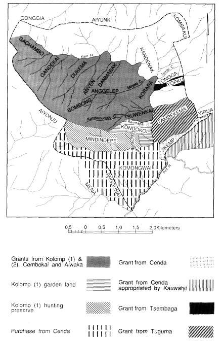
Map.3.
Tsuwenkai Geographic Features and Territories
ate translation, as this implies a sense of absolute ownership. "Fathers of the land" are ultimate custodians of rights to the land. Often, however, they do not retain exclusive, or even primary, usufruct rights, for they may make grants of land to others. The underlying principle of land grants is that it is primary use rights to land which are generally transferred, not absolute custodianship. "Fathers of the land" may thus cede primary usufruct rights, retaining only residual rights. Recipients of primary rights may themselves extend use rights to other individuals or groups, or even make subsidiary grants to third parties. Individual and corporate rights to land thus operate at several levels, being residual or active, older and more general and diffuse, recent or in relation to more clearly defined sites or particular kinds of resources. In certain circumstances, "fathers of the land" may relinquish even residual rights to land which thereby are transferred to new custodians.
The Kundagai recognize several principles by which land rights may be transferred to other groups or individuals. Rights may be given in perpetuity or temporarily for purposes of occupancy or gardening. Rappaport (1968) and LiPuma (1988) have discussed both types of grants. I am concerned here with grants in perpetuity, especially of more extensive tracts of land. These grants are usually made in connection with marriages, but groups can also obtain de jure rights in exchange for a prestation of valuables, or de facto rights that in time come to be regarded as de jure by the occupation of ren wabera , "deserted land."
Affinal transfers of land take two forms. The simplest is where rights of land are granted by wife receivers to wife givers, that is, where there is a counterflow of land against women. In the second type wife givers are also land-right givers. The rationale behind this is that the land is given by a woman's agnates to ensure that she has sufficient gardening land in her new home.
I learned of three such cases involving large tracts of land (see Healey 1985c for a detailed treatment). In two of these, wife and land receivers gave valuables in return for the land to their affines in addition to bridewealth. The third case is more complex, as the same tract of land, or parts of it, were subject to a number of grants but involved differing donors and recipients. The land between Renmapai Creek in the south and the Kant River to the east and north was formerly Kolomp territory. In the mid-1800s all this area was given to Wendekai Kolompepe and Atikai Kolompepe subclans to support their Kolomp wives. The recipient groups extended use rights to all members of the
Wendekai-Amankai-Atikai cognatic cluster. After the fission of the Kolomp, some Kundagai say that the Kolomp (2) clan granted rights over the same area to Cembokai and Aiwaka clans of Bokapai, though the circumstances are unknown to my informants. Kolomp (1) made a further grant of part of the land—Tsuwenkai ridge—to Atikai Kolompepe subclan as part of ongoing affinal transactions, by now consolidated by sister exchanges. After the 1920s fight with the Aikupa, Bokapai clansmen invited the Kinimbong Kundagai to settle in the Kant Valley, and Kolomp (1), Cembokai, and Aiwaka clans jointly granted rights to the whole tract. In return Wendekai and Atikai clans gave women in marriage to the three donor groups. These marriages are viewed as being payment for the land, in consequence of which Tsuwenkai men say the donors cannot dispossess them: they have acquired primary use rights. Nonetheless, if one asks who are the "fathers of the land," informants generally reply Kolomp (2) or Cembokai and Aiwaka for the land north of Kandemunggu Creek, and Kolomp (1) for Tsuwenkai ridge. The Bokapai-based clans retain residual rights to the land although they ceded usufruct rights to Wendekai, Amankai, and Atikai; the Bokapai clans own the land but have no superior right to use it.
The granting of land does not necessarily deprive grantors of active usufruct rights, provided these are periodically activated by productive activity and the sacrifice of pigs in raku . The Kundagai regard the sacrifice of pigs as an essential expression of occupancy and usufruct rights. Success in gardening and hunting is bound up with the maintenance of proper relations with the ancestral spirits that inhabit the land, and clan spirits abandon any land once sacrifices cease there. Kolomp (1) is the only Bokapai-based clan that maintains active raku in Tsuwenkai and which therefore retains usufruct rights in the area.
This principle of pig sacrifice is also given importance by the Kundagai when discussing two other major grants of land that subsequently became subject to dispute. In the early 1900s the Tsembaga granted in perpetuity the lower part of Yopku to support Tsembaga women married to the Kundagai. (The two groups were still on friendly terms.) The recipients (two men of Atikai clan) were assisted by fellow clansmen and cognates of Wendekai and Amankai in making a prestation of valuables in return for the land. The Tsembaga ceased sacrifices at Yopku and, in view of this and the exchange of valuables, the Kundagai argue that all rights in the land have passed to the Atikai descendants of the original recipients, who are now the "fathers of the
land" of Yopku. Other Tsuwenkai residents wishing to garden the area should first seek permission of these men.
In similar vein, an adjoining tract of land was given by the Tuguma to two Tsuwenkai men: a matrilateral parallel cousin of Atikai clan and an affine of Amankai. Both men joined a party of Tuguma resident at Tambekema in the Kant Valley. The Atikai man gave valuables in return for the grant, and when the Tuguma returned to the Simbai they ceased use of the land and sacrifices of pigs there. The senior descendants of the original recipients are again the "fathers of the land" and have extended usufruct rights to all coresidents.
More recently, the Tsembaga and Tuguma have pressed claims to be recognized as "fathers of the land" previously granted to the Kundagai and to regain exclusive primary usufruct rights. The Kundagai justified their own superior claims to all rights to the land by recounting the history of the grants and stressing that they periodically sacrificed pigs at Yopku and Tambekema, whereas the Tsembaga and Tuguma had long since ceased to do so.
Aside from grants, Kundagai territory has also increased through the purchase of land from other groups in recent times. These transfers are complicated by the de facto rights the Kundagai held in these areas by virtue of their occupation of what they considered was deserted land.
Before their defeat and rout at the hands of the Kauwatyi in 1955 the Cenda territory included large tracts of land in the Pint and Kant Valleys. The Kundagai helped both the Cenda and Kauwatyi and supported many Cenda in refuge after their defeat. In appreciation the Cenda transferred to the Kundagai the tract of land shown on map 3, most of which became part of Tsuwenkai territory. Much of this area was formerly part of the territory of the original Kolomp settlers of Tsuwenkai but was incorporated into the Cenda territory when some Kolomp joined that clan cluster. Most of this land had long been neglected by the Cenda, and the Kundagai, considering it ren wabera , deserted land, had gardened on it. Some Kauwatyi had also gardened on Komongwai and, at the time of the grant, were extending their cultivations there. The Kundagai saw this as an attempt by the Kauwatyi to establish de facto rights to this land. The grant from the Cenda was timely, as it gave the Kundagai primary rights to the land and legitimacy to demand the removal of the Kauwatyi. The Kundagai were not entirely successful in pressing their demands, although the Kauwatyi withdrew their gardens on Komongwai to the lower slopes above the Pint River, where they continue to garden. The Kauwatyi, however,
also quickly occupied most of the wedge of land stretching from the Kant River to Mount Yirua. The Kundagai did not press their rights here, and they now consider that the Kauwatyi have become "fathers of the land" south of Jikemp ridge by virtue of long and continued occupation and sacrifice of pigs. Significantly, LiPuma's ethnography of the Kauwatyi indicates a heightened concern for access to land compared with other Maring local groups. This may be attributable to a comparatively high population density and local perception of pressure on land (see also Lowman 1980).
In about 1959 or 1960 the Cenda demanded payment for the land. The Tsuwenkai Kundagai made a payment only for the land on the west of the Kant. Several women were given in marriage, as well as shell valuables, steel tools, and bird plumes. Bridewealth was received for the women. The Bokapai Kundagai made a similar payment. The Kundagai now claim to be "fathers of the land" and therefore to be free to make use of it for cash-earning ventures, such as coffee plantings. Since the Kundagai do not consider themselves "fathers" of the Jikemp grant, they say it would be unwise to use the land for bisnis (TP: "cash-earning activities").
The Kundagai of Kinimbong and Tsuwenkai seem never to have appropriated land vacated by defeated enemies. The Bokapai Kundagai have expanded their territory in this way on at least one occasion. About the turn of the last century the Went-Kai clan lived in the Mieng Valley near Bokapai. Their land extended into the high-altitude forest at Aiyonju. Following a dispute the Went-Kai were routed by the Kundagai and fled to Rinyimp where they still live with the Kolomp-Kambek. Somewhat later two Wendekai men of Tsuwenkai gave a pig to their Went-Kai mother's brother for sacrifice in his sickness. In appreciation they were granted permanent usufruct rights to Aiyonju. The Kundagai had already gained de facto rights there, by gardening in the lower slopes and harvesting forest products in the high forest. The Went-Kai still consider themselves, nonetheless, to be "fathers" of Aiyonju land and have forbidden the Kundagai to make bisnis from the land by hunting valuable birds for trade—an injunction that has so far been ignored.
The grants of usufruct rights discussed here differ from those treated by Rappaport (1968) and LiPuma (1988) in that they involve large tracts of land of marginal use to their original owners because of the distance from settlements. Generalizing from these few cases, I suggest it is easier to obtain both exclusive usufruct rights to and custodianship
of land obtained from other clan clusters. This is perhaps partly a function of distance—other populations are less able systematically to exploit the land because of its distance from their homes, and they are therefore less likely to press their claims as "fathers of the land," either implicitly by the sacrifice of pigs there or explicitly through statements of ownership. The Tsuwenkai Kundagai have acquired land in exchange for valuables or women or both from the Tsembaga, Tuguma, Cenda, and Bokapai Kundagai. Only the Bokapai Kundagai are still acknowledged as "fathers of the land," although all Tsuwenkai informants agree that no Bokapai clans, with the exception of Baikai (l), have any right to garden or harvest valuable forest products on this land. The transfer of ultimate custodianship thus may also be a function of ideas of in-group and out-group. It is not possible, however, to draw any firm conclusions concerning such transfers, in view of the vagueness of Kundagai notions regarding them. The situation is further complicated by recent claims by the Tuguma, Tsembaga, and Went-Kai to continuing rights and custodianship.
The Kundagai assert that all residents of Tsuwenkai are free to clear gardens in any part of the whole territory. Although the area south of Renmapai Creek is Kolomp (1) land and the area to the north is held jointly by the Wendekai-Amankai-Atikai cognatic cluster, individual sites are held by particular males. Initial ownership of garden plots is achieved by clearing the primary forest. Such sites generally are inherited patrilineally, but grants in perpetuity to other cognates or affines are commonly made. By these means individuals gain primary gardening rights to specific sites located in landholdings of other clans. To plot the garden sites of individuals does not reveal any clear pattern of clan territorial holdings. Garden sites of Wendekai, Amankai, and Atikai men are more or less evenly distributed throughout the whole area of agricultural land from Anggunai to Danmarak. Most Kolomp (l) gardens, however, have been cut south of Renmapai Creek within Kolomp (l) territory and the land purchased from the Cenda. Although specific garden sites are spoken of as being owned by individuals, these men in fact own usufruct rights, while the "father of the land" is the corporate group within whose territory the site is located.
During his first patrols to Tsuwenkai, kiap Griffin, who established the government station at Tabibuga, recorded boundaries for Tsuwenkai territory, an exercise no doubt prompted by armed clashes between several Jimi groups over territorial disputes. Griffin evidently relied largely on Tsuwenkai informants to determine the boundary, for the
line he declared as the official boundary corresponds to Kundagai notions (see map 3) with exceptions at only two points. Griffin declared that the northern boundary of Tsuwenkai should follow the Bismarck crest. The Kundagai, however, assert that there is no territorial division between Mounts Aiyunk and Kombaku but that Tsuwenkai and Kinimbong lands constitute a single territory within which members of either settlement are free to garden or harvest forest products, because members of both settlements comprise a single clan subcluster. Members of the Wendekai-Amankai-Atikai cognatic cluster have equal usufruct rights to the whole estate of lands occupied by them in Tsuwenkai and Kinimbong. Other Kundagai clans that do not share rights of usufruct to this land are not entitled to garden on it or extract valuable forest products without permission. Few Kinimbong Kundagai avail themselves of their right to garden or harvest in Tsuwenkai because Kinimbong is more fertile. Many Tsuwenkai members of Wendekai, Amankai, and Atikai clans occasionally garden in the lower altitudes in Kinimbong, and most maintain groves of breadfruit and Gnetum trees (TP: tulip ) and marita pandanus there, as these fare badly in Tsuwenkai's colder climate. Baikai (1) technically shares this right, though it is unclear if Baikai (2) does also. The issue has not arisen and informants are reluctant to express an opinion. No other clans based in Bokapai or Tsuwenkai have this right except on invitation. There is ample lower-altitude land in Bokapai where special crops may be grown or game hunted.
The second section of the boundary established by Griffin which is not recognized by the Kundagai lies on the east side of the Kant Valley. Griffin ruled that the boundary should follow the Bismarck crest from above Jikemp to Mount Kombaku. Some Kundagai also state this to be the present boundary. Most declare that the site of the new road has been the eastern boundary of Kundagai land since the Tuguma and Tsembaga land grants. The Tuguma and Tsembaga's claim to repossess the land below this level, mentioned earlier, occurred sometime before I entered the field, and there had been some discussion of the issue in informal kot (TP: "courts," but here referring to discussion of disputes) at Tsembaga. The Kundagai say these claims were inspired by the expectation that the road being cut in the Kant Valley might open up the forests to commercial exploitation. No further kot were held during my major period of fieldwork. By 1978, the matter had been referred to a committee of the Jimi Local Government Council, but no decision was reached, and by 1985 the claims seem to have been in abeyance.
With the grant of Komongwai and Anggunai from the Cenda and its subsequent purchase, the southern boundary of Tsuwenkai was extended so that Bokapai and Tsuwenkai land met in the zone of human habitation. Formerly the two territories met only in montane forest. Residents of either territory, as members of different clan subclusters, do not have the right to extend their gardens across the Anggunai border. Baikai (1) may garden north of Anggunai because of their association with Atikai. Informants suppose that Baikai (2), associated with Wendekai, might also do this, but none could recall any case where they had gardened in this region.
Tsuwenkai Kundagai claim that they do not garden in Bokapai territory but complain about encroachments on their land at Anggunai by Bokapai men. The incursions of the Kauwatyi on the lower slopes of Komongwai do not prompt serious complaints, probably because their activities are at a distance from Tsuwenkai settlement and gardens, whereas sites cleared by Bokapai Kundagai abut onto Tsuwenkai gardens, thus reducing the amount of land in easily accessible regions available for new Tsuwenkai cultivations. Tsuwenkai complaints about encroachments by Bokapai men have gone no further than occasional grumblings and fistfights.
The Kundagai tolerated the Kauwatyi annexation of much of the Cenda grant on the east of the Kant Valley because this area was far from the settlement and therefore unsuited to more intensive cultivation. It is probable that they also did not wish to antagonize a powerful ally who had already revealed expansionist designs by occupying Cenda land adjoining Kauwatyi borders elsewhere. Since this annexation, however, the Kauwatyi have attempted to include more of this former Cenda land within their territory, a move that the Kundagai have successfully resisted with the aid of government personnel.
Although most Kundagai are fairly clear about the location of territorial boundaries, it would be incorrect to suggest that they are concerned about the occasional transgression of gardening rights that these boundaries demarcate. They believe that they have ample land, and although they evidently do not wish to relinquish ownership of large tracts of land, such as are claimed by the Tsembaga and Tuguma, they are tolerant of their Kauwatyi and Bokapai neighbors making gardens inside their territory.
This chapter has reviewed the ecological, social, cultural, and historical context within which the exploitation of forest products and the
exchange of goods is located. In the last few pages I have shown that the population of the Tsuwenkai region has fluctuated considerably and that continuous Kundagai occupancy is relatively recent. There is, however, circumstantial evidence of human occupation of the Tsuwenkai area extending back at least two hundred years (Healey 1985c ). Oral historical material indicates that there was a succession of small, sporadic settlements until around the turn of the century. Tsuwenkai has been occupied continuously since then, although the population remained small but fluctuating for two or three decades. The area thus remained an essentially pioneer zone until recently. In this period much of the land was owned by clans in Bokapai or Kinimbong and exploited primarily as a hunting preserve and only to a very limited extent as garden land by a few resident households. As the region was periodically subjected to more intensive exploitation by larger concentrations of people seeking refuge from hostilities elsewhere, so grants of extensive tracts of land were made to occupants. Although the parameters of past population numbers and the kind and intensity of exploitation cannot be drawn with any accuracy, this historical material points to an important conclusion. There are no grounds for assuming that the ecological relations of humans to the environment in the Tsuwenkai region have achieved a dynamic equilibrium. Most particularly for the present study, one cannot posit any long-term homeostatic relationship between human exploitation of the environment and its direct and indirect effects on bird populations. As it happens, however, the period of continuous occupation, with a population approximating and sometimes exceeding present levels, roughly coincides with the period for which I was able to gather case material from individuals on their hunting and trading histories. The period from the mid-1920s saw a consolidation of a regime of extensive shifting horticulture in Tsuwenkai and an expansion of the zone of human habitation. The effects of human presence on habitat and bird numbers by clearing, hunting and, less directly, by the ravages of pigs, are mainly the consequence of the last few decades. This is a relatively short time in the ecology of both humans and birds. Although the forests had long been exploited for game, in all probability the impact of hunting on bird populations was considerably less than it has been in the last fifty or sixty years. The analysis of the impact of habitat restriction and of hunting by the Kundagai, as revealed by present horticultural practices and case histories of hunting, thus covers the greater part of the period of most intensive,
continuous human occupation of the area. Before presenting an analysis of the ecology of hunting focused on the exploitation of birds of paradise for their plumes, it is necessary to outline the significance of plumes within Maring culture, a matter to which I turn in the next chapter.