7
Holes
[B]y draining the useless inlets of the Cumberland, Welsh, and Scotch lakes, and turning them, with their rivers, into navigable reservoirs and canals, there would be no difficulty in working the whole of our mountain districts as a gigantic quarry of slate and granite, from which all the rest of the world might be supplied with roofing and building stone.
John Ruskin, "The Two Paths," 1859
No account of the completion of a major Victorian engineering project—a great canal dug, a railway trunk line opened—was complete without long statistical accounts of the quantities of muck lifted, rock blasted, and bricks imported. Comparisons with the great accomplishments of ancient Romans or, more often, ancient Egyptians, almost invariably followed. Those who read these celebratory descriptions or listened to triumphant opening-day speeches could expect to be congratulated on living at a time when new skills and machines had opened the possibility of rearranging the surface of the earth to make the way smooth for the wheels of progress. On these occasions, much would be said and written about the huge holes dug. The huge heaps left behind were seldom mentioned.
The contrast between the forces of human beings and the forces of nature is the central theme of a work we have already noticed, Robert Sherlock's Man as a Geological Agent , published in 1922. Its author agreed with Hutten and Lyell that nature's efforts might be described as uniformitarian and deliberate. Human endeavor, Sherlock pointed out, worked in exactly the opposite way, being intermittent, erratic, constantly changing in direction. While the action of wave, wind, rain, and frost wears
away at the soft parts of the land, Sherlock wrote, miners and quarrymen attack the "bony framework" instead. "Where Nature would leave a hill or hard rock, there Man leaves a hole."[1]
As this distinguished geographer was intent on demonstrating in detail, few places on earth had, over the centuries, been more hacked away at and burrowed into than the British Isles, that small but resource-rich part of the global anatomy. Especially in Cornwall, the pockmarks left by Phoenician tin exploiters and Roman lead and iron miners could still be detected. Fresher were the remains of hillocks that had been turned over for their minerals in the eighteenth century. According to Sherlock's calculations, over the course of that century, some 1,700,500 tons of copper ore had been raised from underneath Cornwall and neighboring Devonshire.[2] And near St. Austell, the deep craters left by the still-flourishing china clay industry were ever deepening and production ever expanding. But concentrated though this disemboweling might be in Cornwall and Devon, as well as in Anglesey and Glamorgan, in Lancashire, Durham, Staffordshire, the West Riding, and Northumbria, scars could be found everywhere: little of the epidermis on the national body had been left entirely smooth and unblemished.[3]
Transport being expensive, builders, processors, and farmers looked to their immediate neighborhoods for supply. Almost every city building site had its own clay, stone, or limestone quarry. Tillers of acid soils, needing marl for fertilizer, or masons, needing limestone to make mortar, dug as close as possible to work sites. Road builders and menders pitted the land alongside with sand and gravel holes. Peat diggings, large and small, dotted many landscapes. Saucer-shaped depressions marked the sites of former bell chambers, small mines that were narrow at the top, wide at the bottom, and up to fifty feet deep. Farm laborers who usually worked these deposits might or might not trouble to fill up the holes with rubbish.
These often-unstable cavities occasionally swallowed sheep and cattle, particularly in the clay areas of Hertfordshire and Buckinghamshire.[4] Walkers in Cornwall needed to watch their step. According to a 1858 edition of The West Britain newspaper, a "whirlwind" from a bell pit got beneath the crinoline of a young lady, lifted her over its mouth, and dropped her nine fathoms to the bottom, not seriously injured but "much aftrighted"[5] —a particularly jolting reminder that the land surface of Britain had, over the centuries, not only been thoroughly denuded, converted from one purpose to another, plowed, grazed upon, cut over, and replanted but also thoroughly drilled, gutted, and hollowed out.
Time set to work softening the blight remaining after these older excavations, carried out by hand labor, ceased. Surface wounds tend to heal quickly in Britain's moist climate. Even where the scars still show, it is seldom unambiguously clear where the hand of the digger left off and where the powers of nature took over. This is particularly the case in areas of the Norfolk Broads, where the work commenced by medieval peat cutters was then refashioned by the sea. When does the artificial become the natural or the natural the artificial in such an environment?
Some eighteenth and nineteenth century holes, on the other hand, remain conspicuous features of local regions and do disclose an unmistakable human paternity. One thinks, for example, of lunar landscapes made by the St. Austell china clay diggings, the old slate workings in Wales's Snowdonia, or the brick fields of Flintshire. These were places so dramatically plundered that they became, and some remain, tourist destinations. Centuries of quarrying in Cornwall, it has been claimed, actually "enhanced" its landscape.[6] There, as in ravaged areas of North Wales, visitors were attracted by the "sublime" effects created by some Victorian quarrying operation, particularly where (as was often the case) deep, terraced pits of exposed stone were surrounded by wooded hillsides, smiling fields, and lush pastures.
The sensuous curves of so much of the British topography evoke metaphors having to do with the female form. Sudden and forceful intrusions into valleys, folds, and mounds become, by metaphorical logic, acts of rape. Thus hole diggers "ravish," "defile," and "violate"; yet the long-term effect of these acts of violence, carried out before the age of the bulldozer, have proved to be, if not benign, at least not permanently devastating. Although heaps are the consequence of holes, nineteenth century diggers seem to have fared better in public esteem, over time, than dumpers. Visitors can still admire the great chasms fashioned by Welsh and Cornish slate workers, but even the most enthusiastic among the industrial archaeologists tend to deplore the dead, rubbish-strewn scree around the rims.
This is not to suggest that the Victorians themselves were untroubled when they encountered the raw gashes around the edges of their cities or the cratered surface of the Black Country or the scrofulous stretch of brickfields west of London, extending from Southall to Slough, or the gutted terrain of the lower Medway Valley.[7] Little that could be called sublime, heroic, even tragic, was to be discovered in those dreary waste-lands. The Penny Magazine , dedicated as it was to enlisting its working-class readers in the cause of progress and civilization through industrial
"improvement," nevertheless reprinted in 1835 an extract from an article that first appeared in Knight's Quarterly Magazine . The author spoke of the "miserable tract of country commencing a few miles beyond Birmingham and continuing to Wolverhampton. . . . It was," he wrote, a "dismal situation waste and wild." He remembered that he and his party shuddered to "observe the surface of the desert around them scarred and broken, as if it had just reposed from the heavings of an earthquake." Particularly grim was Bilston, a town that sat on top of coal mines and was steadily subsiding. Foundations of houses and shops, wrote the correspondent, were shrinking, "leaving them in . . . a state of obliquity with the horizon." Another traveler to Bilston a decade or so later reported that subsidence had recently caused an inn near the town's center to fall in. He stated that "many houses in the place may still be seen nodding to each other, fearfully out of the perpendicular." In the surrounding area, in places where the earth had sunk enough to destroy the natural drainage, pools of stagnant, festering water, called swags , shaped what another contemporary described as "a vast rabbit warren."[8]
Undeniably repugnant though such reminders of human destructiveness could be, there was always the comforting thought that without a certain amount of dereliction there could be no civilization. Furthermore there was always the rationalization that, in places like Bilston, the inhabitants seemed willing to sacrifice amenity and even the security of their house foundations for the promise of employment. It could also be argued that many mining families managed to hold on to their small holdings and surrounding gardens and to reclaim patches of broken land for cultivating gooseberries and currants because they had alternative sources of income in the nearby mines and quarries.
In the valley of the river Weaver in north central Cheshire such exercises in positive thinking underwent a particularly severe trial. On one memorable day, 6 December 1880, in an outlying district near the town of Northwich at the Ashton and Sons Salt Works, a ninety-foot chimney, observed for several years to be gradually leaning, collapsed with a roar. Following that dramatic episode, two streams, Wadebrook and Wincham Brook, the latter twenty feet wide, were seen to plunge straight down into a crack that had opened in the earth. Soon after, the Weaver broke through its banks and began filling the emptying stream beds. Between 2:00 and 4:00 in the afternoon watchers were treated to the "grand sight" of water and mud rushing into holes in the ground at an accelerating pace and filling the hollowed-out salt mines. Then, as in Shakespearean tragedy, a deep rumbling groan issued from the depths fol-
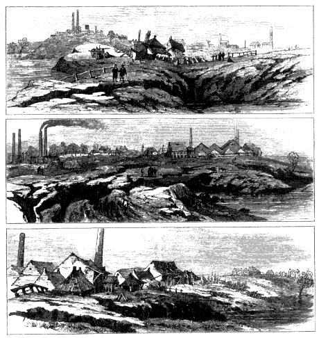
Figure 7.
The Great Subsidence (1880). Panels from the Illustrated London News show
the spectacular results of pumping brine for the alkali industry from flooded
salt mines underneath the Cheshire town of Northwich. (Illustrated London
News 78, 1881)
lowed by a violent bubbling in the many small lakes and pools nearby. Some minutes later twenty- to thirty-foot high geysers of mud and gas, accompanied by the smell of rotten eggs, began to burst through fissures in the earth. A large lake, known locally as a "flash," quickly formed as the surface sank. At the same time the levels of the Weaver and of another already-existing flash dropped when their waters poured into the hollowed-out chambers below. The sinking continued for more than a
month, although on a diminished scale. Of the many subsidences that had occurred in a 200-square-mile area around Northwich for centuries, this was the Great one.[9] (See Figure 7.)
A local newspaper noted that a Northwich evangelist standing at the verge of the "yawning chasm . . . improved the occasion" by giving an impromptu sermon. "Now, my friends," he intoned, "the ground you are standing on is the rottenest in the world and it may all go down with you in a moment while you stand listening to me." In that event, he warned, a fair proportion of his listeners would follow the path of Lucifer and keep falling until they reached Hell's floor. He invited them to reflect on the certainty that "when the end of the world does come, it will come as suddenly as this terrible accident, but instead of the water there will be fire."[10]
Physically, but probably not morally, this part of Cheshire had indeed become one of the rottenest regions in the kingdom. Mining the vast salt field underneath Northwich and neighboring Middlewich, Winsford, and Holford got under way twelve years after explorations for coal in 1670 disclosed a bed of rock salt some 200 feet from the surface. Manufacturing salt by boiling water taken from natural brine streams had been an important part of the local economy, probably from pre-Roman times. By the early eighteenth century, entrepreneurs had made the region into the nation's leading supplier. For the rest of the century small mining enterprises hollowed out underground caverns, held up by pillars of salt. Careless, "hit-and-run" mining methods as well as leakage from the surface and from underground streams gradually wore away or dissolved these supports, causing mine roofs to fall in. One collapse led to others because miners seldom bothered to seal off an exhausted shaft from those adjacent. As these cave-ins were happening, prospectors discovered a second bed 120 feet lower, and from the 1780s most of the rock salt extracted came from the lower level. Inevitably, however, the disintegration and flooding of the chambers above began to break down the cavern roofs of the Bottom Bed, and by the mid-nineteenth century all but a handful of rock salt mining operations had ceased.
But that did not put an end to the industry. Late in the eighteenth century, salt manufacturers had began to pump the brine from a natural underground reservoir above the Upper Bed. In time this method became standard practice. But reserves of natural brine being limited, salt manufacturers experimented with ways of tapping the layers of rock salt. By the 1850s they were using increasingly powerful steam pumps to reach into the flooded mine chambers to bring up what was called "bastard
brine," produced in some cases by inducing freshwater and waiting for it to turn into brine.[11] As the volume being pumped increased and as the wells sunk deeper and deeper below the water table and below the floor of the river Weaver, increasing volumes of unsaturated water began seeping in and turning into solution with the rock salt, thus commencing a period of spectacular subsidences that continued for about eighty years.[12]
Affected most violently by the influx of freshwater were the salt deposits nearest, not the wells, but the places of entry, so that cave-ins often occurred at considerable distances from the pumps. Some local inhabitants assumed that what they were experiencing was the working of nature, a misapprehension the manufacturers were at no great pains to correct.[13] Nevertheless, disquiet had been growing for over a decade as landowners watched their fields sink and fill with water. Farmer Clough, for example, had decided in 1853 to fill in a large hole on his leasehold. Four years later the hole was deeper and bigger. He repeated the process with the same result. In 1867 he dumped in zoo cartloads of clay and some rubbish left over from highway repair work. By the early 1870s the crater in his field was four feet deep and seventeen feet wide. Rents dropped as such pits, often surrounded by widening fissures, became increasingly common features of the countryside.[14]
Residents of Northwich had even more cause to complain. Their buildings, like those in Bilston, began to bow deeply to one another.[15] One public house, the Wheat Sheaf, lasted only fifteen years before disappearing from sight. A company of volunteers came within a minute or two of disappearing with it when a large cavity opened up just after they left their drilling ground in the pub yard.[16] Whole streets of workers' cottages and a great many small shops were lost in the third quarter of the century, although, surprisingly, no lives. In spite of these warnings, town dwellers failed to protest, at least in an organized way. The explanation is obvious: what was causing properties to crack and collapse was what kept the town and increasing numbers of workers alive. Stopping the damage meant stopping the pumps.
Property owners and railway and canal interests did ask for compensation but, in any individual case, had great difficulty discovering the culprit. Many independent saltworks were pumping from the same brine reservoir, and the resulting subsidences appeared as far as five miles from any wellhead. Simply connecting cause and effect did not, therefore, fix responsibility in such a way that courts could easily provide relief. As a result, most townspeople of Northwich and surrounding communities had learned to accept the fact that infirm foundations were simply reali-
ties of life in that part of Cheshire and that anyone who knowingly chose such a place to reside should learn how to adapt. Inspector Dickson reported in 1873 that the new Northwich town hall was being constructed on a strong wooden frame so that when it began to lean, it could be brought back to plumb.[17] Given such a cast of mind, one could no more expect the people of Northwich to be champions of environmental protection than one could expect loggers in a Canadian milltown to be militant protesters against clear-cut forestry.
In looking for a way to make those who profited from brine pumping compensate those who suffered from its effects, Dickson came to the conclusion that blame could only be assigned collectively. A toll on pumped brine should be paid by the salt manufacturers to offset the damage they could not help but inflict. But Dickson also used this occasion to make the point that it was time the whole nation became engaged in an effort to husband mineral resources. He wanted the state to establish some kind of policy to cover all cases where the extraction of minerals from the earth must inevitably cause major damage. It was not good enough, he maintained, for the government merely to place limits on how much might be extracted in any given period: slowing the rate of damage did not affect the long-term results. Such a policy might only delay catastrophe. In the Cheshire salt fields, where steam pumps were extracting much of the brine from below sea level, there was a possibility that brine leakage and subsidence might eventually submerge "very large areas of the salt districts," It was time, Dickson thought, for the state not only to take some responsibility for environmental damage but also to respond to a growing apprehension that coal and other vital resources were not inexhaustible and that mineral shortages might reach crisis proportions in the foreseeable future. Central authorities, he declared, should alert the public and assume control over "the national waste of minerals in general."[18]
The Home Office was not inclined to heed Dickson's call for a national policy on management of mineral resources. Nevertheless, officialdom in general did come gradually to accept that subsidence in the Cheshire salt fields was more than a local matter, that vital economic interests were involved. Alkali manufacture, the backbone of the British chemical industry, depended on a secure and reasonably priced salt supply and the makers of textiles, glass, soap, and paper depended, in turn, on access to the products of the alkali makers. In 1874 John Brunner and Ludwig Mond set up a new plant to produce soda ash by the Solvay process and chose for their site an estate called Winnington, near North-
wich—prudently just outside the subsidence area.[19] The Winnington works, which became part of I.C.I. in 1926, employed 2,000 workers at the time of the Great Subsidence and doubled that number by the outbreak of the First World War.[20] Needless to say, members of Parliament had no intention of placing heavy restraints on the irresponsible "bastard brine" pumpers simply in the interest of preserving the beauty and stability of the Cheshire landscape. A bill to compensate property owners, introduced while new flashes were forming after the 1880 disaster, was stalled by the appointment of a select committee and eventually failed when the industry warned that cessation of pumping would simply allow brine to run into the sea.[21]
A surge in salt production in 1890-91 brought in its train another wave of subsidences. In 1891 Parliament set up a compensation board and empowered it to levy a rate of three pence on every 1,000 gallons of brine pumped. However, framers of the bill made sure that the act only applied to a small area around Northwich. The act also authorized the board that administered this levy to monitor operations and recommend precautions. But the pumping of brine from collapsed mines continued and so did the subsidences.[22] What did eventually control the situation was not government intervention, although that possibility may have been among the incentives, but a new technique for brine pumping first introduced by Brunner-Mond in the 1920s. Known as "controlled pumping," this method sent water at high pressure down boreholes into the rock salt, which, as the freshwater went into solution, fashioned self-contained chambers. Subsidences gradually decreased as more brine pumpers came to adopt this technique.[23]
Significant here is the fact that initiative to control environmental degradation came from a large, highly capitalized company with a long-term stake in the region and a technical staff that functioned as a regular component of the general production process. These advantages were not shared by the partially integrated Salt Union, a loose amalgamation formed in 1888, of many small companies. However, Brunner-Mond's initiative could not be called environmentally sensitive, at least by the present usages of that term. An attraction of the Winnington site was that flashes and sunken fields seemed to be ideal dumping grounds for industrial wastes. Although the Solvay process used far less coal than the older Leblanc method, quantities of ashes and cinders still had to be disposed of. For years this refuse as well as waste products of salt boiling had gone underground.
But much more troublesome was calcium carbonate, a useless by-
product of alkali and soda manufacture—three quarters of a cubic yard of this effluent for every ton of salable product. This lime waste material is deliquescent, meaning that it becomes liquid upon absorbing moisture from the air. It is gray, slimy, and semiplastic. If it is spread out on the earth, it must be covered with several feet of earth; otherwise a deathlike pallor will settle over the landscape. And this was the product that filled sunken fields, sometimes diked to extend their capacities, along the river Weaver. The company sealed off several flashes and dumped chemical wastes into them. The effect, when touches of rubble from decayed saltworks were added, has been described as the very "picture of desolation," and a "nightmare landscape of devastation."[24] A decision, adopted in the 1950s, to pump this glutinous mess into the bore holes created by the controlled pumping method was a "solution" of sorts, but not one likely to reassure the ecologically minded.[25]
Sherlock used this relationship between man-made holes and subsidences and man-made waste disposal to demonstrate the "apparently erratic manner in which Man interferes with nature." He also wanted to emphasize that this kind of behavior made it "particularly difficult to estimate the net result of his activities."[26] He took as his prime example Ashton's Flash near Northwich, a product of the Great Subsidence. In 1896 soundings taken in a straight line showed the flash to have depths ranging from 80 to 110 feet; in 1906 the deepest measurement was 50 feet. In the intervening years, quantities of sandstone scraps left over from excavations to make docks at Liverpool and leavings from the construction of the Manchester Ship Canal had been transported up the Weaver in an attempt to give the constantly subsiding flash bottom firm underpinnings. On top of that went about one and a quarter million tons of waste, mainly dredgings from the river, along with ashes and clinkers from coal used in salt and alkali manufacture; but, as in the case of Farmer Clough's hole, so much weight caused more subsidence and, by 1906, maximum depth had fallen to 110 feet. In the meantime, considerable subsidence had occurred in those Lancaster coal fields that had supplied energy to Northwich industry. Sherlock's conclusion was: "Man's great engineering feats are so widespread that it would be a Herculean task to sum up their total effect on Nature."[27] And, as he admitted, when some Herculean geographer had completed that task, it would then be time for the biologist to begin.
Such a consciousness of the intricacy of the relationship between geological and biological processes and the fragility of what we now call the ecosystem might be thought of as typical of the twentieth century
approach to geomorphology and the place of humans in it until one remembers that Sherlock's inspiration had come from Marsh's writings in the 1860s. What then do we find in the story of nineteenth century subsidences that seems peculiar to the time? One obvious answer is that governments, at all levels, took a far less active part in regulating and were not pushed to adopt a more active policy by highly organized pressure groups and well-informed public opinion. It was not until the Control of Pollution Act of 1947 that the law required waste disposal sites to be licensed and not until the Deposit of Poisonous Wastes Act of 1972 that the precautions resource extractors would need to take before being licensed were made specific.
Regulations governing underground and strip mining and quarrying procedures appear to contrast sharply with the Victorian policy of laissez-faire. Modern governments, in principle at least, accept some responsibility for protecting the environment; nineteenth century governments only acted to control polluters or defacers in exceptional cases. But the contrast is perhaps not really so sharp as that. The older hands-off policy encouraged powerful interests to develop in ways that had profoundly disturbing effects on the landscape; late twentieth century ministries and bureaucracies do the same, only more directly and actively, subsidy to agricultural "improvements" being the most prominent example.
A clearer contrast between then and now is that subsidence, a major environmental issue in the nineteenth century, has now all but ceased to be so.[28] The explanation is obvious: subsurface mining has lost its eminence as a British enterprise. John Barr's passionate indictment of modern despoilers in his Derelict Britain (1969) does not even mention subsidence in his catalogue of horrors. Today, exploiters of mineral resources tend not to hollow out or pump out the material beneath the earth's surface but are inclined instead to use powerful machines to dig into and expose the coal or other mineral deposits. Thus it is the new technology of resource exploitation that marks our time off most conspicuously from the past.
Only indirectly was steam technology a crucial factor in the huge nineteenth century expansion of the mining and quarrying industries. It is true that the application of steam energy to industry and transportation caused an enormous outpouring of coal, iron ore, copper, stone, clay, tin, lead, zinc, salt, sand, and slate. Rapid improvement in pumping and hauling technology, especially in the early part of the century, allowed mines and quarries to reach deep below the water tables, but by
no means all of these pumps and hoists were steam driven. Waterpower had a longer life than most people, until fairly recently, have been aware.[29] In general the effect of this deepening and enlarging process was to allow more and more workers to reach the face or wall and saw, hack, drill, and chisel—using traditional tools, skills, and muscle power. One innovation, Nobel's dynamite, began to be used in blasting from the 1870s onward; but techniques for digging, cutting, and lifting, although assisted occasionally by steam power, hardly improved until late in the century. As we have already noted, steam-powered earthmoving machinery was invented surprisingly early, but it was not a significant factor in either quarrying or strip mining until the early decades of the twentieth century.[30] We hear of accidents being caused by hand-operated, brakeless cranes in slate mines and quarries as late as 1895.[31]
Given enough time, of course, the constantly increasing application of animal and human labor could produce some prodigious dents in the land surface. Two quarry industries in particular, granite and slate, created some spectacular holes and in a variety of ways left conspicuous imprints not only on the countryside but both directly and indirectly on almost every cityscape as well.
A combination of a fictional and geographic Sherlock would be required to follow all of the essential clues leading to the great expansion of the first of these, the granite industry, from the late eighteenth century to the late nineteenth. A good place to start would be London and its remarkable nineteenth century physical expansion. Even before a dozen railway stations ringed the central area in the 1830s, 1840s, and 1850s, horse-drawn vehicles had been crowding the streets at an alarming rate: cabs, omnibuses, delivery carts, heavy freight wagons. Horsepower brought supplies to factories and food to wholesale markets, did most of the transshipping and, until electrified trams entered the streets late in the century, moved a large proportion of the nonpedestrian commuter population from suburbs to underground stations or to workplaces. The resulting traffic crisis, coinciding with the first in a series of cholera epidemics in the 1830s, alerted the influential part of the public to the urgent need for public health reform and street improvements, among them efficient street-cleaning techniques.
The need to ease the way for ironclad wheels and hoofs and to provide hard surfaces for scavengers led various parishes within the city to begin paving the most heavily used passageways with granite setts from the 1760s on. On secondary streets they laid down macadam surfaces. These were composed of broken granite pieces, rammed until their rough
edges crumbled to form a more or less impermeable, but far from permanent, carriageway. As these passageways filled with traffic, there was a tendency to differentiate the parts of streets required for human and for animal feet and this created a demand for stones and paving materials suitable for curbs and footpaths.[32] By 1911, Aberdeenshire quarries were sending 30,000 tons of granite setts to London annually.[33]
Less utilitarian considerations also created new markets for granite. Churchyard burial inside the major urban areas ceased at midcentury and the era of the great Victorian cemeteries commenced. The desire of middle-class people to leave behind a permanent record of their existence made them or their families willing to pay for elaborate memorial tombstones and monuments. Granite's durability made it the stone of choice. At the same time, the urban rich sought to express their sense of civic pride in the great municipal halls and other public buildings that still give distinction to the old centers of provincial cities. City fathers also sought durability. Thus a longing for material reminders of both public and individual immortality as well as the wish to keep urban streets and groundwater supplies clean put skilled craftsmen to work blasting, chiseling, grinding, and polishing in Cornwall and Devon quarries and mills and especially in the great granite deposits on both sides of the river Dee in Scotland's Aberdeenshire.
Now, well inside the modern urban sprawl of Aberdeen lie the remains of the most famous of these, the Rubislaw Quarries. From above, the huge cavity looks like the crater left by a meteor strike. Standing on the edge of the sheer drop of this "muckle hole," one looks directly down at a pool of dark water that hides the old quarry bottom, 180 feet below.[34] Perhaps no other city has so conspicuous an exhibit of its origins—the "Granite City" constructed out of itself. According to a former stonemason, William Diack, quarrymen used to claim that "the half of Aberdeen has come oot o' that hole." Diack thought that far too modest an estimate.[35]
From the eighteenth century well into the nineteenth, some six million tons of granite had been lifted to the surface, much of it carried on two-man litters. As the pit deepened, hand cranes and then, in the 1850s, steam cranes replaced some of the muscle power; although Diack, who worked at the quarry in the 1920s and 1930s, remembered watching teams of horses carting "junks," "half ware," and "litters" up the old winding roadway.[36] Long before, muscle power had been assisted by an invention made in 1872 by John Fife, the owner of nearby Kemnay Quarry. This was a device called a "blondin," after a French tightrope
walker who had crossed Niagara Falls on stilts.[37] It consisted of two wire ropes, the lower one having a skip attached that could be lowered to the quarry floor, loaded with stone, and raised by machinery to the surface.[38]
Quarry companies sent finer stone from the lower levels almost everywhere. Fashioned into blocks, this material faced buildings and built bridges, docks, and lighthouses. Charles Rennie and Thomas Telford used Rubislaw granite and the silver gray stone of Kemnay for their Thames bridges. Some of the world's finest stone craftsmanship can be seen in the beautifully fitted blocks of the Thames Embankment, also quarried at Kemnay. It is Aberdeenshire craftsmanship that finds an enduring memorial at London's Kensal Green and Highgate Cemeteries.
Although it got its start much earlier, in so many ways, the Aberdeen granite industry was a Victorian industry. Rubislaw, for example, prospered by the conversion of city centers from residential areas into offices, shops, theaters, monuments, and other civic amenities. Construction of massive viaducts, embankments, and tunnels to serve the new railway system also made heavy demands on suppliers. The quarry, like other extractive operations, depended on skilled craftsmen and on subcontracting rather than on standardization, piecework, and centralized management.
"With the Victorians, and how appropriately," wrote Jacquetta Hawkes, "granite came into its own." This rock, "the pillar of Victorianism"[39] had its heyday in the 1890s and then declined in popularity when asphalt surfacing became more common and when artificial building materials and the use of thin veneers lightened the fabric of steel and reinforced concrete structures. As the substantial old bourgeois class declined in influence, the taste for solid granite monuments and buildings declined as well.
Also like most heavy Victorian industries, granite quarrying was noisy, dirty, messy, and unsightly. Lying above the Rubislaw granite deposits were some thirty feet of "tirr," or hard boulder clay. This needed to be brought to the surface. Coal miners could often deposit waste materials in worked-out chambers, but granite workers needed to keep the way clear to the quarry floor where the best quality of stone was to be found. Quarry companies were then under no legal obligations to restore the landscape to something resembling its earlier state. So the great hole deepened and expanded until Rubislaw's final demise during the Great Depression. When the pumping stopped, the quarry filled halfway up with water. While still functioning, Rubislaw was one of Aberdeen's main tourist attractions; once the quarry ceased to be active, the city,
perhaps embarrassed at having in its midst so conspicuous a reminder of declining enterprise, ringed it with a thick border of trees and later a high wire fence, effectively sealing it off from the surrounding houses, commercial enterprises, visitors, and passing traffic.
That the gaping cavity left behind by the quarrymen of Rubislaw could be so easily isolated from its modern environment by some relatively simple screening points to one feature of granite quarrying that makes it different from Victorian coal, slate, mineral ore, and clay extraction industries. It tended not to ravage an entire area or to poison the environment so severely that the technology then available was unable to hide the dereliction, prepare the site for some new use, or find ways to market the rubble left behind. Granite scraps could be ground in mills at the quarry lip and used to make mortar and road beds and surfaces.[40] In the late Victorian period, managers responded to the demand for suburban gravel walks and garden paths by installing special grinding machinery. They also turned waste into profit when they discovered that fine granite powder could be mixed with cement and formed under great pressure into those hard, dull gray blocks still used extensively on city pavements. Dust from this grinding and pulverizing was a menace to the health of the humans who did the work, but it tended not to contaminate the soil. On the contrary, feldspar and mica, two of the components of granite, break down into carbonates, which are plant nutrients.
Waste taken from quarries and mines could seldom be profitably disposed of, but the holes left by abandoned workings proved highly useful. Detritus from cities could be dumped there. Ashes and cinders made up more than eighty percent of household refuse at the end of the Victorian period. Some of this material found its way into plaster and bricks, but most of it went into landfill or disappeared down a convenient hole. Although the quantity of rubbish per person much increased in the later twentieth century and contained far more durable and toxic material, the possibility of disposing of it underground, often in abandoned Victorian excavations, meant that Britons, who discarded 3.2 pound of solid waste per person every day in 1988—nearly the same quantity as the world's leaders, the Americans—spent less to dispose of it than any other Europeans.[41]
Holes left unfilled could often be used to provide recreational facilities, increasingly in demand from the middle of the nineteenth century, when more time could be spared for leisure pursuits and when civic reformers became interested in supplying the urban working class with facilities for "rational recreation." A favorite of do-gooders was swim-
ming. Old quarry holes were ideal for this purpose, particularly ones much more modest in size and depth than Rubislaw—as the great majority of stone quarries were. Copper, lead, iron, and zinc digs often exposed minerals that reacted with air and water and released toxic chemicals, making them unsuitable for reservoirs or swimming holes. Coal and clay tips usually contained at least some iron pyrite. This oxidizes into sulfuric acid. Stone wastes, on the other hand, were relatively nontoxic; thus water accumulating in abandoned quarries was usually safe and clear.[42] Cavities left by quarrying this material could also be safely fashioned into small urban parks or playing fields. Sometimes they were converted into cemeteries. A particularly impressive one is St. James's churchyard, built between 1825 and 1829, next to Liverpool's Anglican cathedral.
Thus in leaving behind a permanent legacy of dereliction, Rubislaw tended to be an exception. Many rock, sand, and gravel holes, especially if they were close to urban areas and not too densely concentrated in one region, eventually added variety and amenity to the landscape.[43] The Victorians carried out no conversions on the scale of, for example, Thorpe Waterpark, just outside London, where a large area that had been pockmarked with gravel pits was turned into a large lake surrounded by zoo hectares of sporting grounds after the Second World War.[44] Nevertheless Victorians began the process of reclamation and did so on a scale that merits recognition.
No such credit can be given the Victorian exploiters of slate deposits located in some of the loveliest parts of North Wales. Several of the quarries there were so massive that they turned men and machinery into tiny dots. Viewers registered shock and gave signs of having experienced intimations of mortality. Poets of the sublime were moved to speak of "the gulf profound" and painters and engravers were moved (one thinks especially of John Martin) to convey on paper or canvas the human capacity to create Pandemonium here on earth. From the late eighteenth century on, no tour of the mountainous ranges of Caernarvon or Marioneth was complete without a visit to these vast, artificial cavities. Visitors were, as often as not, struck by the disconcerting contrast between the beauty of the countryside and the man-made scars it bore. At the same time, they were impressed by this evidence of human capacity to form caves almost as mammoth as those fashioned by nature. A German tourist in the 1840s remarked that the slopes of North Wales looked like they had "been bitten into."[45] A contributor to Macmillan's Magazine in 1864 spoke of how "no mountainside is so inaccessible that the slate
prospector has not reached it." The "thunder of the quarrier's blast," he continued, echoes through "the most secluded glens and passes."[46] Visitors were awed by the sculptural effects slate workers had created and often dismayed by the litter they left behind.
The reason why the shattered detritus around slate quarries accumulated is that only five to ten percent of the material that was chiseled, blasted, chopped, and raised had any use.[47] The brittle rock breaks down slowly and, unlike granite, provides little nutrient for plants.[48] Waste could not be disposed of in the deepening holes so long as work was going on. Also, the waste dumps for most Welsh quarries were located in remote places, usually on steep inclines, that could not be conveniently or economically used for landfill. Here and there, as at Blaenau Ffestiniog, the slate was mined. But according to Sherlock, of the nearly 17 million tons of usable slate taken from the ground between 1874 and 1913, two-thirds came from open pits from which overburden had to be removed before any valuable rock could be taken out.[49]
In the most efficient quarries, quarrymen needed to excavate something like a hundred tons of useless rock for every three and a half tons of marketable product. To make sure a deposit was worth exploiting, prospectors first stripped away and dumped this rubble and decomposed slate. This made prospecting a risky venture and caused hillsides to be disfigured even when no fireplaces, roofing materials, or school blackboards and writing slates ever came out of them.[50] Before Richard Pennant could begin quarrying on a massive scale at Penrhyn or Thomas Assheton-Smith could do the same at nearby Dinorwic, workmen had first to cut out and haul away an "inchoate mass of rubbish, heaps, and holes" left behind by generations of "old people" who dug into hillsides and pried out what lay conveniently to hand.[51]
As in the granite industry, most prospectors and developers were small operators who leased or rented the mineral rights and contracted out the actual work, sometimes vein by vein or gallery by gallery. That meant that work might start and stop and proprietorship might change hands many times, depending on shifts in the market. Under those circumstances, it would be the rare entrepreneur who would even think to repair damage that so many different agents had inflicted. The government did take a belated interest in the welfare of quarrymen. In 1879 mining inspectors laid down a set of safety rules, and Parliament passed an act in 1894 establishing special quarry inspectors. Nevertheless, it will come as no surprise to learn that, during the discussion preceding this legislation, no one even suggested that the health and safety, as well as the
beauty, of the countryside should also be a concern. It was only following the Second World War that strip mining and quarry ventures were required by law to carry out any form of reclamation after operations ceased.[52]
Where slate quarrying was rationalized, the landscape gained some spectacular chasms. But there was a downside: since even the most highly capitalized operation never discovered a way to convert waste into a useful product, the landscape also gained mountainous piles of gray detritus. On his way to visit the famous Blaenau mine in the 1870s, a tourist approached nearby Ffestiniog village. What first caught his eye were the huge piles of rubble, squatting like dark blots on a remarkably beautiful landscape. The monochromatic effect was, he discovered, sustained inside the town: parapets, curbstones, roofs, chimneys, mantlepieces, kitchen tabletops, the mud in the road—all were slatey blue.[53] By then that color was imposing itself almost everywhere, but it was especially noticeable in the terraced housing of industrial towns and villages. Builders had been roofing with slate for centuries. Canals and coastal carriers had made slate roofing available to the well-off, but it was not until the arrival of railways in North Wales during the third quarter of the century that this uniformity was imposed on so much of the nation.[54]
"The Industrial Revolution may have been founded on textiles and powered by steam," writes Merfyn Jones, but "it was roofed with slates skilfully wrenched from the Welsh Hills."[55] This is true in spirit but not in letter. The factories and mining towns of the industrial Midlands were commonly built of local materials until steam transport in the mid-Victorian period made slate cheap enough to roof mills and worker housing in inland areas. Blue, was the pigment Wales added to the national palette but not until the first industrial revolution had been consolidated.
Steam technology brought cheap slate roofing to the national and international markets but, as in the granite industry, played only a supportive role in bringing the product out of the ground. This was so even at the great mines and quarries of North Wales: Penrhyn, Ffestiniog, Dinorwic. Steam- and water-powered saws usually worked side by side on the finishing level. An American invention, the steam-driven Burleigh rock drill, was tried out in several Cambrian quarries in the 1870s.[56] Penrhyn acquired its first steam pump in 1807.[57] Occasionally, steam cranes or windlasses did some of the lifting. But experience showed how awkward it was to transmit steam-generated power over distances. When electric motors became available as early as the late 1870s, they were quickly taken up. This happened about the time that slate production,
which had reached its peak in 1898, began to experience competition from artificial roofing products and a consequent decline in demand.[58] The great mine at Blaenau Ffestiniog practically skipped over the period of steam technology, advancing almost directly from muscle and water-powered devices to electrical ones shortly before the First World War.[59]
Until then, waterpower remained crucial, especially the water balance. This was an iron tank equipped with wheels, running up and down the quarry side on rails. Filled at the top with water, it descended and pulled slate and rubbish to the top. When it reached the bottom, workmen drained it and sent it back up.[60] This was a slow process and required quarries to construct extensive reservoirs, which meant that drought or frost could put a halt to operations. Even so, steam technology proved insufficiently flexible to allow for a thoroughgoing mechanization of the rock and ore extraction industries. The overwhelming spectacle presented by the great amphitheater at Penrhyn, until the mid-twentieth century the largest excavation in the world, was literally sculpted out of a mountainside by human hands, aided by horses and by machines nearly as old in their workings as civilization itself.
A lithograph of Penrhyn, made by W. Crane in the early 1840s, places the viewer on one of the lower shelves of this amphitheater.[61] In the foreground is a group of visitors, one a woman in shawl and bonnet. On their level, wagons, loaded with slate, are being pulled by a two-horse team down the gallery incline on metal rails.[62] Below and above, other teams are also moving their freight around and around the circling ledges (or benches) before cranes lower it to the quarry floor. Once there, it will be split or sawed into roof slates, gravestones, chimney pieces, tabletops, and counter tops, and sent, usually along horse- or locomotive-drawn tramlines, to railheads and ports. Puffs of smoke on opposite sides of the great semicircle mark the places where blasting powder is loosening slabs of black slate for the skilled rockmen, using hammers and wedges and crowbars, to process into blocks.
The impression Crane gives is of a great, terraced chasm, fashioned by antlike perseverance into a hugely dramatic artifact. This artifact we, like the well-dressed tourists seated before us, are meant to view with awe and, having viewed it, to consider how wondrous are the works of man. Continued reliance on hand and animal labor supplemented with steam pumps and lifting devices meant that great holes like this one could be viewed as dramatic incidents in an otherwise untroubled landscape. Whole regions left flailed and derelict inspired other, less exalted, emotions.