Chapter Four
The Rural Landscape of Greece Today
TO RESCUE FOR HUMAN SOCIETY
THE NATIVE VALUES OF RURAL LIFE
Inscription on Hilgard Hall,
University of California, Berkeley.
These words, carved perhaps seventy years ago, are apt to sound either sentimental or affected in the 1980s. Yet, passing under the inscription nearly every day for more than three months, I developed a growing sympathy with the aspiration that it expresses. Field archaeologists working in Greece are indeed inclined to wax sentimental over the rural environments in which they often find themselves, but this does, I think, reflect a genuine attachment. It is certainly true that a number of archaeologists today are engaged, if not in rescuing, at any rate in studying the contemporary rural values of Greece, with a view to using them in their reconstructions of the ancient counterparts.
In modern times, the Greek countryside has successively been the victim of a series of processes, each destructive in its different way. Many Western visitors seem to see it and its inhabitants as a kind of living museum, and find it difficult to treat the modern Greek villager as a contemporary, let alone an equal. For the small subgroup of the Western visitors who are professionally interested in its past, the landscape itself is often seen as a sad and mistreated relic of a different and superior past. I considered this view in the previous chapter and found certain grounds for thinking it a misrepresentation. The history of the view, if correctly
reconstructed, certainly supports that conclusion: it grew up with the flowering of classical studies in northern Europe, and it embodied not only a conjectural picture of the past landscape, but also a definitely mistaken impression of the contemporary one. When experience proved the falsity of the latter element, a way presented itself of salvaging what remained: the "true" landscape of Greece could still exist, provided that it did so only in the past.
I can write of this view, not as a disdainful onlooker, but as a former adherent, at least in part. An education that combines relative familiarity with the ancient texts and total ignorance of the physical realities is no longer a common experience for young people today, at least in the Western world; but I can recally my own feelings of shock more than thirty years ago on first encountering the real Mediterranean landscape, first of Italy and then of Greece. The standard translations into English of the Greek vocabulary for nature—terms like hule (wood), bessa (wooded glen), potamos (river), krene (fountain), and poa (grass), and their Latin counterparts—had been downright misleading as a preparation for confronting the actual features denoted by this vocabulary. Was it possible that this muddy trickle corresponded to that historic river-name? Where had the green glades with their nightingales gone? As we saw in chapter 3, an explanation lay to hand, simple, apparently credible, and attractive above all to the classicist: the landscape described by the classical poets and historians had vanished with them, the victim of environmental degradation, and consequent climatic deterioration, in the post-classical era. This is in many ways a comforting view, and may not be mistaken in its entirety: to prove it so would require much more extensive research than has yet been undertaken. All that I argued in chapter 3 was that it has no great basis or justification in the ancient authors; that the findings of modern research into the question are inconclusive; and that, as a more economical working hypothesis, we should instead adopt
the opposite assumption, that the ancient rural landscape of Greece was, in many important aspects, much like that of Greece today.
Or at least, of Greece yesterday: for we come now to the latest of the processes of destruction—this time in a literal, not symbolic, sense—that the Greek countryside has suffered. The physical degradation of the rural environment, which is now a subject of worldwide concern, has not spared Greece. On the contrary, although tact and a consciousness of sentimental nostalgia urge reticence upon me, I do not recall seeing a more intense and apparently unchecked manifestation of this disease of our times anywhere else in the world. The spread of surburban building and second homes, the ubiquitous replacement of stone and brick by concrete, the paths of destruction left by the tractor and the bulldozer, the neglect or demolition of terracing, the idiosyncrasies of Greek planning and taxation legislation, and, above all, the universal dumping of refuse in an age of plastics, have all contributed to a degradation that is more than merely visual. This catalogue must not be allowed to degenerate into a tirade: it should be remembered that not all these processes are in themselves undesirable, and admitted that many of them are, in practical terms, irreversible.
Yet there is one minor side effect of this process that is acutely relevant to our present topic: the increasing pace of destruction of antiquities in rural sites. Here, curiously, the action of the law, which in other respects is recognized by everyone (including successive Greek governments) as being too permissive, even supportive of environmental damage, has the opposite effect. Because Greek antiquity law imposes a blanket prohibition on the destruction of ancient remains until they have been professionally investigated, a direct clash of interests has been set up between government agency and majority public opinion. This is turn has brought a trail of unhappy consequences: a spate of clandestine building, a detectable change in the popular attitude
to Greece's archaeological heritage, and a massive addition to the burdens laid on the Archaeological Service. It is neither my business nor my aim to argue contemporary political questions; but it is open to anyone to wonder how long the present balance of forces can remain unchanged, and it is not difficult to diagnose the underlying cause of the trouble in theoretical terms. If there is one glaring ideological contrast between ancient and modern Greece, it is the change in, indeed the inversion of, the relative evaluation of public and private interests. The language that gave us the word idiot and its derivatives to describe the man who stood aside from public life now employs these terms freely in a neutral or occasionally commendatory sense, most often to warn trespassers off private property. The rural landscape is a mute witness to the fact that this change of values is no mere philosophical abstraction.
All of this lends a certain urgency to the questions that I shall raise about the form of future archaeological work in Greece; but it is not the only practical consideration operating to that effect. I have referred in passing to the difficulties under which the Greek Archaeological Service labors, and I hope that it will not seem too presumptuous to enlarge on them a little. The unselective preservation of Greece's material heritage, which is a cause so estimable in principle that almost nobody would speak in public against it, has brought about another, less obvious crisis. The historically conscious visitor to Greece today is rightly impressed by the steady increase in the number of local museums and in the quality of exhibition. What he or she may not appreciate—and I think that this is true even of classicists and other "professionals" who are not archaeologists—is that what is actually displayed is merely the beautiful tip of an unsightly iceberg. Almost every museum in Greece is compelled to conceal in its storerooms a mass, growing year by year at an alarming pace, of material unsuited to exhibition, which is often unpublished and
sometimes destined to remain so. If the Archaeological Service were rewarded, either in salaries or in manpower, on a scale that bore some faint relation to the colossal indirect contribution that its activities make to the nation's tourist industry, then one could look ahead to a possible reduction of the pressure. As things are, the only prospect is that it will rapidly increase: even to keep pace with the rate of growth in the "submerged nine-tenths" of its holdings, the service would need an appreciable increase in manpower. Much of the material has to be stored in improvised accommodation, difficult of access for study; meanwhile, its keepers are distracted by the ever more persistent demands of emergency excavation, generated by the factors already mentioned.
The activities of the foreign missions in Greece make a contribution towards shouldering one of the burdens, through their undertaking rescue excavations when asked. But, since they must necessarily share the same museum facilities, they inevitably aggravate the other main burden, by adding to the growth of the unseen "apotheke [storeroom] mountain." The problem is not peculiar to Greece but, because of the exceptional richness of Greece's archaeological heritage, it appears there in its acutest form. Any excavation, even that of a ten-meter square undertaken to prepare the way for the building of a modest office block in a provincial town, is likely to produce a significant crop of material from a variety of periods, spanning millennia rather than centuries. Some answer to the problem has to be found in the near future: the option of a total moratorium on all but emergency excavations, which used to exist only in the context of examination papers for classical students, begins to move in the direction of serious possibility. It is time to ask ourselves whether our appetite for new objects, connoted by the invocation "Kala vremata! " ("Good finds!"), which is still regularly heard at international gatherings of archaeologists, is something that can be
allowed to be satisfied indefinitely. Can it not, perhaps, be separated from the appetite, entirely justifiable and indeed desirable, for new knowledge ?
If accepted, several of the arguments used in earlier chapters would tend to limit the value of the traditional aims of excavation in Greece. These, like earlier comments published by me in this vein, are bound to arouse resentment in some circles. It is clear, for one thing, that a general adoption of the ethos of the new archaeology in Greece would result in an alteration of the balance between the two entities just mentioned: new objects and new knowledge. A concrete instance is available from the past twenty years of fieldwork in Greece, from the publication of the results of survey and excavation by the University of Minnesota Expedition in Messenia (and, one might add, from the reception of that publication). This work has undoubtedly generated new knowledge in a very much higher ratio to preserved finds than has elsewhere been the rule. For an appraisal of the verdicts on this project, I turn to the first place where anyone would look for a really candid assessment of anything new in the archaeology of the eastern Mediterranean: that is, to a review by James D. Muhly. "Nichoria," he writes of the site chosen for test excavation after the expedition's survey work had been completed, "is perhaps the most eroded site ever to be excavated in Greece. . . . If Nichoria had been excavated in the traditional manner, by archaeologists interested in monumental architecture and museum-quality artifacts, the result would have been an utter disaster." In the event, what we have is an extremely informative excavation report to add to the earlier publication of the results of the survey. Muhly warns that: "There is one very unfortunate consequence of this. Nichoria will, in the minds of many scholars, confirm a deeply held belief that the 'New Archaeology' . . . is an archaeology of last resort, something undertaken when all else fails. In the words of one of its critics, it is the archaeology you do when you do not find anything." He goes
on to exemplify such a reaction: "When one has the frescoes of Akrotiri who is going to bother collecting soil samples?" But the sting is in the tail: "It is precisely the lack of proper scientific excavation at Akrotiri that is responsible for most of the nonsense published about Thera during the past ten years."[1] I should like to associate myself with every word of these opinions: it is pleasant to feel that one has at least one ally and sharer in the retribution that awaits those who express views of this kind.
<><><><><><><><><><><><>
There is one branch of archaeological work—in some senses, it is an application of the new archaeology—that has the effect of bringing together almost all the strands of argument that I have deployed in this chapter and its three predecessors. It offers classical archaeologists a chance to make use of the distinctive strengths of their own discipline, but in a way that will only be fruitful if they work in collaboration with the practitioners of other disciplines. It enables them to contribute substantially to a different branch of historical study from the traditional, event-oriented political one, and to do this on the scale, not of a single, restricted locality, the site, but of a region . It explores the rural sector of ancient Greek life on which our ancient sources are most defective, and corrects the urban bias of the past century and more of excavation in Greece. It generates relatively little in the way of preserved finds, but an almost endlessly exploitable store of new knowledge. It is (as many readers will long since have guessed) intensive archaeological field survey. The excavation of Nichoria, which we considered just now, was primarily the by-product of the first great pioneering survey venture in Greece, the Minnesota Expedition of the 1960s. A series of further projects, mostly on a more modest geographical scale, has followed the lead of the Minnesota team, but the application of
[1] J.D. Muhly, review of Excavations at Nichoria in Southwest Greece, vol. 1, AJA 84 (1980): 101–2.
this technique to the exceptional circumstances of Greek archaeology must still be reckoned to be in the experimental stage. Shortcomings and downright errors are still likely to occur. But one further advantage of survey as a method is that such shortcomings and errors can be made good later, in a way impossible with the essentially destructive technique of excavation. A stretch of terrain can be surveyed again and again at suitable intervals, whether by the original team or by others, to check on the original results. The processes of nature and the agricultural activities of man, which are responsible in the first place for bringing to the surface the archaeological material from which field surveys obtain their information, will continue to operate everywhere except where external destructive forces have prevented them from doing so.
But I have preferred to exemplify rather than generalize, and in line with this I now propose to offer a small selection of the findings of the Cambridge/Bradford Boeotian Expedition, which since 1979 has been jointly directed by John Bintliff of the University of Bradford and myself, with the help of colleagues and students of several disciplines from both these universities, and from others as well.[2] I have tried to prepare the ground somewhat in the previous chapter by setting out the picture of the rural landscape of Boeotia obtained from those ancient sources that give the fullest account of that region; this formed the background against which we began our work. As we saw, the picture is a meager one, even though Boeotia fares as well as most regions of Greece in this respect. The example of the fragment of Herakleides Kritikos showed us that the approach of the writers of antiquity did not, in principle, preclude them from giving us valuable information in this quarter; rather, it is the vagaries of survival
[2] The reader is referred to an extensive preliminary report entitled "The Cambridge/Bradford Boeotian Expedition: The First Four Years," Journal of Field Archaeology 12 (1985): 123–62, for a more detailed account of the questions raised in this chapter.
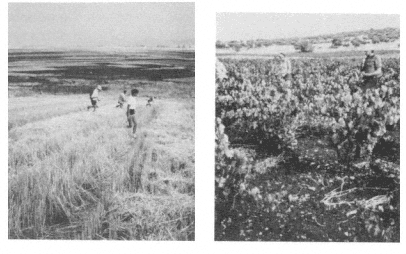
Figures 19, 20.
Two views of field teams carrying out intensive survey in Boeotia, 1981.
of texts that has left us with so bare a picture of the rural economic geography of ancient Greece. But, as it happened, the part of Boeotia where we elected to work was not one that Herakleides described: it embraces parts of the ancient territories of the cities of Thespiai and Haliartos, where the two abutted. Herakleides found a contemptuous pretext for not troubling to visit the former place, and mentioned the latter only as a byword for the stupidity of its inhabitants.
Our coverage of the terrain has been as intensive as that attempted in any part of the Mediterranean world, or so we believe; for this reason, our progress has been relatively slow, and the area surveyed in the five seasons to date amounts to less than thirty-five square kilometers. Figures 19 and 20 exemplify some of the conditions with which field survey in Greece must reckon. A harvested cornfield, where a team of five or six people can move in a straight line and in clear view of one another, may invite smooth and rapid progress; yet the conditions under foot, with a stubble and straw cover, will demand extremely careful
examination of the surface if anything is to be seen. Conversely, a well-kept vineyard or freshly ploughed ground under olive trees will make it very difficult for the team to preserve its alignment and orientation, yet the walkers' view of the ground surface immediately in front of them may be almost complete, and show up each artifact perfectly. Allowance must be made for these and other factors when estimating the significance of the visible scatter of material on the surface, and before venturing to infer its relationship with what lies under the ground.
These problematic aspects of surface survey have led some archaeologists to take a very skeptical view of the potential contribution of the technique as a whole. Others have doubted the specific value of the intensive variety of survey I am describing. More productive, in their view, is the selective coverage of a much larger tract of land, in which the likely locations for sites are identified in advance, and then examined at close quarters for surface traces. Each side in this latter debate can advance persuasive arguments of an a priori kind, with considerations of thoroughness and objectivity on the one side being weighed against those of productivity and historical significance on the other. It will be obvious that intensive survey is very much more laborious and expensive in proportion to the size of the area examined than is survey of the second, "extensive" kind. For us, the decisive factor in making the choice is an empirical finding of the simplest kind: in every case where intensive survey has been attempted in Greece, it has revealed a density of sites on the landscape that is very much higher—at times, by a factor of fifty or more—than that revealed by surveys of the extensive kind. (In Greece, the extensive survey projects were mostly a feature of the pioneer years in the 1960s and early 1970s, while most of the more recent projects have been intensive; Figure 21 shows, on a logarithmic scale, the magnitude of the change in site recovery that has come about with this adoption of new tactics.)
Now this result may appear predictable, to the point of leaden-footed banality. But it poses a searching question to the expo-
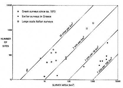
Figure 21.
Graph of site densities yielded by extensive and intensive surveys in Greece (after J.F. Cherry).
nents of the extensive approach. It means that there is something there on the ground, capable of being revealed if the terrain is searched in its entirety, but unlikely to be discovered by the extensive method, or any other selective mode of investigation. We shall presently be going into the question of the significance, indeed the reality, of the pattern of "sites" that the intensive surveys claim to have unveiled, but whatever the outcome of that examination, it seems to me that to exclude the recovery of such patterns from the outset can only be justified if their historical significance is negligible or nonexistent. It will, I think, prove difficult to maintain such a point of view for very long.
At this point, it will be useful to consult again Figure 15, a map taken from an authoritative classical atlas, showing the picture of the relevant part of ancient Greece that can be gleaned from other sources. As is apparent, the density of place-names is low and the detail (apart from timeless natural features) minimal. If it be objected that this map dates from 1906, one may reply that
an up-to-date version would, for the classical period the map purports to illustrate, have very little indeed to add. A similar rejoinder could be given to a plea for a larger-scale map: there would be no further details to be inserted. The only substantial class of further information one could include would be that yielded by modern archaeological work, and this would have to be expressed mainly by symbols, since many of the locations have no known ancient name attached to them. We have seen in the previous chapter the explanation for this state of affairs: the knowledge and interests of the ancient writers, on whom the compilation of such maps depends, do not extend to giving a detailed picture of any part of the rural landscape of Greece, unless it chances to have been the setting of a major battle or campaign.
When we compare this with Figure 22, a modern map of the same region, a difference emerges. The modern map is of course greatly simplified, and includes only a small proportion of the toponyms in current use and the features that could be included if the scale were larger. Nevertheless, it incorporates a distinctly higher number of settlements, more closely spaced, than the ancient map. This difference would be easily explained if the population in antiquity had been much lower, or concentrated into fewer and larger settlements (or both) than is the case today. Yet there are strong grounds for thinking that, at least for this part of ancient Greece, neither of these explanations is valid; and our own work has only served to add to these grounds. As a consequence, one might predict that the ancient landscape held a number of as yet undiscovered settlements, perhaps of the same general order as the modern villages with their populations of between one and three thousand, perhaps smaller and more scattered; some might be places as substantial as certain of those whose names and locations we happen to know, and that consequently appear on the map. One part of our purpose was to search for such settlements.
As things stood early in 1984, when the series of maps that follows was drawn, the area covered by our survey took the shape

Figure 22.
Map of modern Boeotia.
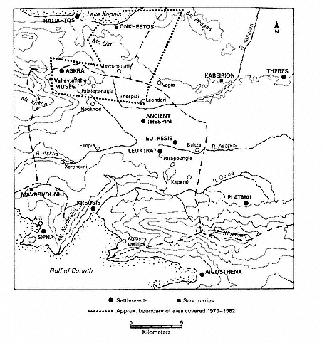
Figure 23.
Boeotia survey: location map of area under study.
of a large reversed L in west-central Boeotia, with the vertical arm running from the edge of the Kopais basin near Onchestos in the north, almost to the site of ancient Thespiai in the south; from the latter, a horizontal arm ran westwards up the Valley of the Muses almost to its head. This block of land (Figure 23) extended into the ancient territories of two, or possibly three, of the cities that belonged to the Boeotian League: the northern part of
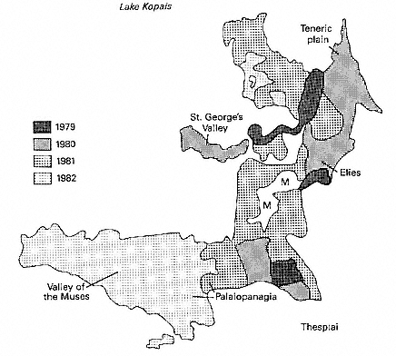
Figure 24.
Boeotia survey: annual coverage and nomenclature, 1979–82.
the vertical arm lies at least in part on ground that belonged to Haliartos; the southern section of this arm, and the whole of the horizontal arm, is in the territory of Thespiai; and a small sector towards the northeast may at times have been in the western extremity of the land of Thebes. The last-named was easily the largest and most powerful city of ancient Boeotia, but Thespiai too was a major power, and its urban center lies much closer at hand. Figure 24 shows the annual progression of our survey across this tract, always extending outwards in a contiguous block of land,
centered on the modern village of Mavrommati, which has served as our base.
Figure 25 shows the distribution of prehistoric sites found, ranging over the period of more than 3,000 years from the Late Neolithic to the dawn of the historical period in Greece. The distribution is both thin and patchy, perhaps suspiciously so. There appears to have been a long, if intermittent, tradition of settlement in the low-lying area at our northern extremity, close to the edge of the Kopais basin. A second, somewhat denser, nucleus of settlement lies to the southwest, on the land over 1,000 feet above sea level in the Valley of the Muses; but the intervening space seems empty. Thus far—that is, in relation to its unevenness—there is a case for thinking that this distribution may reflect the realities of the prehistoric settlement pattern; but the arguments involved are of some complexity, centered round the questions of climate and of preferred agricultural land in prehistoric times, and perhaps relating also to the partial draining of the Kopais basin in the later part of the Bronze Age, and they are not directly relevant to our purpose here. But the overall thinness of the distribution is another matter, and here we suspect that the realities may not be fully reflected in our results. The probable reasons have to do with the whole nature of surface survey. Most laymen are surprised to hear that visible traces of ancient settlements, recoverable without excavation, are to be found on the modern land surface of Greece. That this should be so of even earlier periods is yet more surprising, considering the many centuries of more intense activity that have elapsed in the interval. It is the activities of the plow, with other agricultural operations, that are responsible for these visible traces, and these will not normally penetrate more than a short distance beneath the present surface. For the prehistoric land surfaces to have been penetrated, lying as they often do several feet below the modern level, we may be in part dependent on classical cultivators who mingled prehistoric material with their own debris; some small remnant of that prehistoric material may survive, along with the later
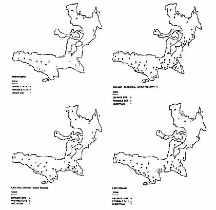
Figures 25, 26, 27, 28.
Boeotia survey: four maps showing site distribution of Prehistoric, Archaic to Early Hellenistic,
Late Hellenistic to Early Roman, and Late Roman periods.
evidence, to be visible today. But this is likely to yield only an incomplete picture of the prehistoric settlement pattern, and we suspect that some prehistoric sites lie entirely hidden under the soil, at least in cases where their location did not happen to coincide with settlements, or intensive farming activity, of the historical period.
The relative scarcity of our prehistoric sites becomes apparent once one makes the comparison with Figure 26, a map of the settlements covering the period between approximately 600 and
200 B.C., that is the Archaic, Classical, and early Hellenistic eras. Here is a period when, on any account, population was at a higher level than at any stage of prehistory, but on the other hand it covers a vastly shorter span of time. What is immediately striking is the high, though not absolutely even, density of sites across the landscape. In the area of only twenty-one square kilometers covered by these maps, there are some sixty-six definable sites of this epoch alone; and in a further season of work in 1984, both the density of sites in general and the overwhelming preponderance of this period were maintained, with the total rising to over a hundred. The great majority of these sites can definitely be stated to have been occupied over a narrower time-span, the fifth and fourth centuries B.C., whether or not their life extended earlier and later too.
The next significant feature is one that is not apparent from the map: the very small average size of these "sites." About two-thirds of them are represented by a scatter of material that is half a hectare (5,000 square meters) or less in area: that is, equivalent to a square of about 70 meters by 70, or a circle with a radius of just under 40 meters. When the debris of a settlement, even after some natural dispersal, covers so small an area, this imposes strict limitations on the interpretation of the nature of such a "site." To this, one of the most interesting of the questions raised by archaeological survey, we shall return presently. Meanwhile, it would be reasonable to ask how we establish the existence and nature of what we call our sites.
Intensive survey means the coverage of a landscape, or of a carefully chosen sample of a landscape, in its totality, as far as that can be achieved. Inevitably, there are some insurmountable barriers created by nature, or by the conditions of the present day: cliffs, impenetrable vegetation, and the presence of modern housing or of enclosed land. These apart, our aim has been to cover every piece of ground, at a level of intensity fixed by spacing the field walkers at the maximum interval that will still allow nothing of significance to slip through the mesh (Figures 19, 20).
After a period of experimentation, we found that in normal conditions this interval was fifteen meters. The team counts every pre-modern artifact that is noted, over the entire landscape. For much of the time, the counts are low, though seldom nonexistent; a sudden increase in density indicates the potential proximity of a site, and at this point we halve the interval between walkers, so as to conduct a total count of everything visible on the surface, rather than merely what is within each walker's view. If the density level is judged to confirm the presence of a site, then the team advances in very small rectangles, ten meters by thirty, until the whole area of high density has been covered and its boundaries defined on all sides (Figure 29). The most scientific procedure might seem to be to fix an absolute density level as constituting a "site"; but one thing that survey has taught us is that there are great variations in the "background" density of finds away from the sites, according to the type of landscape over which we are walking. This fact suggested to us that the "site" level should instead be defined relatively to this "background" level. This might appear to be a worryingly subjective method, but the plain fact is that in an area of rich "background," whole stretches of terrain attain a density of finds that would be taken to constitute a site in a "poor" area; yet within them lie nuclei of much higher density still. It is reassuring that in all areas we find relative concentrations of finds of the same order of magnitude in extent and with the same classes of material represented. Clearly, different levels of intensity in occupation and in agricultural operations, whether in antiquity or more recently, are producing differential traces on the landscape. We are content to interpret the concentrations of finds that we thus encounter as sites.
Two commodities are invariably found in profusion at such locations: potsherds and fragments of roof tile. Occasionally the outlines of buried structures are visible, but more often there are only isolated stones, which may be recognizable as detached building blocks. Even without excavation, the presence of under-
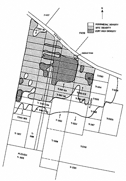
Figure 29.
Boeotia survey: specimen plan of a classical site ("Palaiopanagia 7," 1981).
lying structures can be confirmed by the use of geophysical survey, with the aid of an instrument measuring the resistivity of the earth that has been successfully employed on a number of our sites. It will give an indication of the visual impression conveyed by a site if I record the fact that a major settlement, in an area of intense occupation, can produce from twenty to fifty pieces of sherd or tile per square meter . Clearly, when this happens there is no difficulty in confirming that a location of past settlement, or at least concentrated activity, has been found. In other cases, the decision may prove more difficult. But there is one other factor that has been of the greatest utility in establishing the reality of our sites: it is the fact, already mentioned by implication, that the great majority of the sites give advance warning of their proximity to the field teams through the existence of a "halo" of finds surrounding the actual nucleus, with a density lower than that of the site itself, but markedly higher than most of the "background." It is seldom that we find such a halo without a site at the center of it, and, conversely, the small class of sites that lack such a halo calls for a special explanation. When a density map of the whole area is prepared (as in Figure 30), the nature of the "halos" becomes apparent: they form an added argument for believing in the reality of the sites. Opinions differ as to the historical causes that have generated these halos (for they have often been encountered in survey work elsewhere). Are they no more than the result of the dispersing action of modern plowing, spreading a nucleus of ancient material across a somewhat wider area? Careful experiment has shown that this is unlikely to be the main explanation, let alone the whole truth: more probably, they are mainly the consequence of the ancient agricultural process of manuring the infield area round the site, with fragments of tile and sherd being carried along with the manure. Thus, for example, sherd scatters of much more recent historical periods in Britain have been found to correlate with the areas known to have been under cultivation at the period in question, and to be
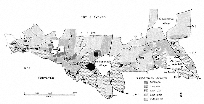
Figure 30.
Boeotia survey: total density map of artifacts in the Valley of the Muses, Palaiopanagia, and Thespiai areas, 1979–82.
absent from known areas of woodland or heath.[3] We thus learn one further fact about our sites: that they usually formed the foci of intensive ancient cultivation.
One advantage of surveying in Greece, as against other regions of prehistoric and ancient settlement, is that there is a relatively accurate chronology of pottery styles that enables one to confirm not only the existence of a site but the main period or periods of its occupation. Thus one can trace the changes in the settlement of a given area through time, comparing for example the high density of sites in the period from the Archaic to the early Hellenistic with the lower density of the period of approximately equal duration that immediately followed: between roughly 200 B.C. and A.D. 200 (Figure 27). Many complications still arise when one seeks to combine the temporal and the spatial dimensions in this way. One must allow for the possibility that the sites of one period, though more numerous, may be smaller in average size than those of another. Our method of subdividing each site into a multiplicity of small components enables us to cope with this factor, at least to some extent. More problematic is the possibility that a scattered rural population may later have been concentrated in an urban center without any fall in total numbers; here the next logical step is to extend one's survey to cover known ancient city sites, as we propose to do. But in the particular case of the two periods under consideration, when all possible allowance has been made for such factors, the conclusion still emerges that the whole level of human activity in our part of rural Boeotia fell markedly.
Here once again the archaeologist working in Greece can draw on the peculiar advantages of his position and appeal to a series of literary authorities whose statements, sometimes applied to Greece as a whole, sometimes to Boeotia specifically, reinforce the impression that the findings of the survey correspond to eco-
[3] See T. M. Williamson, "The Roman Countryside: Settlement and Agriculture in North West Essex," Britannia 15 (1984): 228.
nomic reality. One of the earliest indications comes with the warnings of Isokrates in the fourth century B.C. about the impoverishment of Greece as a whole and the growth of a class of wandering, landless people. More specific reports appear in later authors: Polybius, in the second century, writes of the depopulation and the fall of agricultural production in Greece (36.17.5), and in another passage describes the especially acute symptoms of economic breakdown in Boeotia (20. 4–6). As for Strabo and Pausanias, whose accounts we considered in chapter 3, the striking feature of both their descriptions of Boeotia is that they present town after town as being deserted altogether under Roman rule, or at least drastically reduced from its former size and status. These authorities of course span a long period of time, and are not all equally reliable; it is satisfying, therefore, that independent glimpses can be obtained from more specific documents, such as the second-century B.C. Boeotian inscriptions prescribing measures to combat grain shortages. There seems little to contradict the picture that is emerging, in which the changing face of the landscape revealed by our survey is matched by accounts of shrinking or deserted country towns, with all that that implies about the decline in cultivation.
The picture would be incomplete, however, if no reference were made to its quite unexpected sequel: unexpected because, this time, there is little documentary evidence to prepare us for it, and what there is maintains a generally pessimistic tone. For the fact that emerges from our survey—and it is now confirmed by the findings of certain other fieldwork in quite different parts of Greece—is that, some time around A.D. 300, a great revival in rural settlement took place, one sustained until at least the sixth century of the Christian era (Figure 28). The number of rural sites returns to something approaching the level of the Classical and early Hellenistic periods and, even more interestingly, the individual locations chosen for this revival were in most cases the very same ones that had been occupied in the earlier epoch, and then abandoned for some centuries. This probably means that
the old buildings, however ruinous, were still partially preserved, and that it was easier to rehabilitate them than to build afresh. In many ways, the fourth to sixth centuries of the Christian era form the second most intensive period of exploitation of the landscape in the whole five-thousand-year history of this part of Greece.
We come now to the most central and important question of all, at least for the period of classical antiquity: how are we to interpret the nature and function of the sites that we have located? Let us recapitulate their main characteristics: they are mostly very small, and often spaced at an interval of only a few hundred meters from one another. They produce quantities of pottery, which in nearly all cases includes household pottery in coarser fabrics as well as painted ware. They also virtually always produce roof tiles, showing that they incorporated permanent structures. Finally, the existence of a "halo" surrounding nearly all of them suggests that intensive cultivation, especially in the immediate vicinity of the site, was a concomitant feature of their occupation.
This combination of features has suggested to us the provisional conclusion that most of our sites were independent farmsteads. It remains provisional because of a number of difficulties that stand in the way of this hypothesis. We may begin with the most general ground for objection: this picture of a populated landscape is not what one might expect to find in the "world of town-dwellers" that belongs to the Mediterranean area. It is not, for example, characteristic of certain post-classical periods (leaving the question of prehistoric times on one side), and it is emphatically not the picture of the landscape of Boeotia today, when virtually the entire population is concentrated into villages and towns and, except at peak harvest periods, the countryside becomes totally deserted at dusk. Then there are more specific problems, of which I shall enumerate three. First, there is the fact that the sites still appear in the immediate approaches of the city: it may be recalled that the site of ancient Thespiai lies only just
off the southern edge of the maps shown in Figures 25–28 above. What advantage would a landowner derive from living on his property if it lay within such easy commuting distance of the city? Secondly, there is the question raised near the beginning of chapter 3 about the system of land inheritance: if it is really true that in ancient Greece, as today, an individual's landed property was likely to be divided into a number of small, widely separated parcels, then permanent residence on any one of these might, logistically speaking, be even more disadvantageous than living in the city. Thirdly, we should recognize that not even the possession of a tiled roof would necessarily designate an ancient (or modern) building as being for human occupation; nor, even if it were, would the occupants need to be the owner and his family, rather than tenants, slaves, or a bailiff. These "compromise" solutions should all be borne in mind as possibilities, together with the suggestion of second residences for people who also had a house in the city: let us recall, in this last connection, Plato's prescription in the Laws (746e) of two houses for each of the 5,040 citizens of his ideal state, with the second one being located towards the outer extremities of the city's territory.
As far as the nonarchaeological evidence on this matter is concerned, we can cite epigraphic evidence for the existence, especially in Hellenistic Boeotia, of permanent and even fairly valuable structures on plots of land outside the city.[4] But the words used to denote these buildings—aule is one of the commonest—are neither very specific nor (as is the way with ancient Greek
[4] For examples in the territory of Thespiai, see M. Feyel, "Etudes d'épigraphie béotienne," BCH 60 (1936): 175–83, 389–415, especially 179, lines 29, 34, and 38; 182, lines 24–26; 394 n. 1; and 397–400, 403, and 413. Particularly helpful is E. Cavaignac's discussion of an inscription earlier published by M. Holleaux, "Prix de terres dans la Grèce et l'Asie Mineure," REG 66 (1953): 95–99. The text from Hyettos (see above, Feyel, 394 n. 1) is further discussed by R. Etienne and D. Knoepfler, Hyettos de Béotie et la chronologie des archontes fédéraux entre 250 et 171 avant J.-C. (BCH suppl. 3, 1976), 244 n. 911. For an example from Thisbe, see IG 7.2225, line 25.
terminology) invariable in their meaning.[5] They could perfectly well, for example, describe animal shelters temporarily shared by human occupants at times of peak agricultural activity (thus explaining the household pottery), round which would be concentrated vegetable plots or other intensive cultivation (thus explaining the "halo" of dense sherd cover generated by manuring). The question is unlikely to be settled without fresh kinds of evidence. Even so, the mere existence of these structures, in the periods where they occur, is enough to show that the countryside of this part of Boeotia must have worn a very different look from its appearance today, when one may walk for several kilometers across the landscape without coming across a single permanent building outside the villages.
By way of contrast, it is worth saying a word about the very small group of sites that possess quite different features, and to which probably none of the explanations considered above can apply. They are smaller even than our average "farmstead" sites; they do not normally have a conspicuous "halo" around them; and the pottery that they produce is well above the average, both in respect of its original quality and in that of its present preservation, seldom including any coarse ware at all. As professionals may already have guessed, we interpret these as small rural grave plots or cemeteries, some of whose burials have been disturbed by relatively recent cultivation. But their location, sometimes in decidedly out-of-the-way spots, may one day be brought to bear on the broader questions of landholding and residence that we have been discussing.
In terms of Greek history, and indeed of Greek literature, it is however a handful of our larger sites that is likely to arouse wider interest. We have in fact found half a dozen classical sites of well above the standard size, ranging for the most part between two
[5] As shown by R. G. Osborne, "Buildings and Residence on the Land in Classical and Hellenistic Greece: The Epigraphic Evidence," BSA 80 (1985): 119–28.
and five hectares in area, and three of these merit special reference. First, there is the site we call "Plains B2." Over two hectares in size, it contains a number of dressed building stones, and it has produced three examples of something infrequently found in surface surveys, namely inscribed potsherds. All are too fragmentary to produce informative readings, but by their mere existence they suggest the interpretation of the site as a sanctuary, where dedications of any kind might be inscribed. The site lies at the northern edge of the Teneric Plain, and is just under a kilometer to the east of the known site of the sanctuary of Poseidon at Onchestos (of which, indeed, it may be no more than an outlying and subsidiary element); a short distance northeastwards again lies the Mountain of the Sphinx, whose location can be fixed from literary sources. In this general area, Pausanias (9.26.5) mentions a sanctuary of Herakles the Horse-Binder (Hippodetes ), which has never been definitely located. Albert Schachter, the foremost expert on Boeotian cults, has suggested to us the possibility that this sanctuary could be our site.[6] There is the difficulty that Pausanias, coming from the east, mentions it as coming before the Mountain of the Sphinx, which is "further on," but we have perhaps considered Pausanias's methods sufficiently in the previous chapter to show that this is not an absolutely conclusive objection, although it is still awkward.
At a similar distance on the far, western side of Poseidon's sanctuary at Onchestos lies another, even bigger classical site, which we have called "Plains A5." Here we have found no inscriptions, but there is the biggest concentration of building stones that has occurred anywhere in our area, including a piece of a Doric cornice; furthermore, within the area of the site a small Greek excavation in 1973 had brought to light what appeared to be an agora , or civic center, of the Hellenistic period. This site,
[6] But W. Judeich, in "Das Kabirenheiligtum bei Theben, i," AM 13 (1888): 85–86, suggested a different site, somewhat further east and on the opposite (southern) side of the Teneric Plain.
whose surface area was about five hectares, was surely a small urban center. Here we are able to suggest something that runs counter to orthodox interpretation: when Pausanias visits Onchestos, he finds what he describes as poleos ereipia Onchestou , the ruins of the city of Onchestos, adding that in his day the temple and statue of Poseidon, together with (as we saw in chapter 3) the sacred grove of trees, still survived. Now his use of the word polis has been taken, since the days of J. G. Frazer, to have been loose: he is simply referring to the conglomeration of buildings that would arise around any major sanctuary. We now propose that he meant the word in a stricter sense: there was after all a town of Onchestos, otherwise hardly recorded in history and certainly not an independent city (it lay within the territory of Haliartos), but still an urban center. This would also explain why Herakleides Kritikos, in the catalogue of the localized vices of Boeotia that forms the parting salvo of his description, includes Onchestos in what is otherwise a list of nine major Boeotian cities.[7]
For our third site, we move southwards and uphill to the Valley of the Muses (Figure 31). For us this has always been, in more than one sense of the word, sacred ground. It is, first of all, by far the densest area of rural settlement that we have encountered. Not only are the sites relatively large and numerous, but the "background" level of finds between the sites remains at an almost continuously high level along the valley floor. Partly because it lies well over 1,000 feet above sea level, it is also the pleasantest area for summer walking, as well as the most scenic, that we have seen in Boeotia. It is, too, the prime wine-growing locality of the region round Thespiai; fine trees, perennial streams and springs, and high-quality land help to make up a delightful landscape (Figures 32–33). The overall density plot of finds in this part of our survey, included in Figure 30, throws some kind
[7] F. Pfister, Die Reisebilder des Herakleides , Sitzungsberichte, Österreichische Akademie der Wissenschaften, Philosophisch-Historische Klasse, no. 227, vol. 2 (Vienna, 1951), 180, 183.
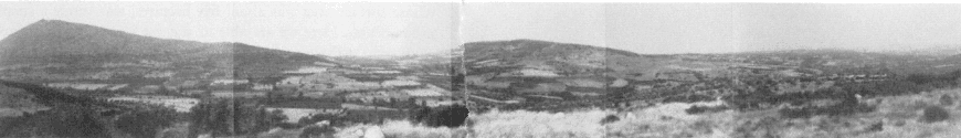
Figure 31.
Panoramic view of the Valley of the Muses, Boeotia, from the south side.
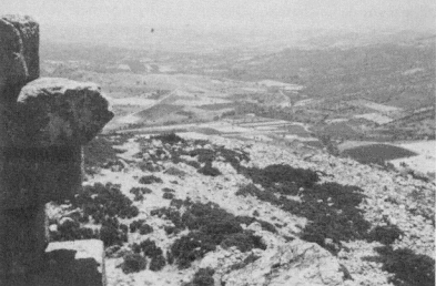
Figure 32.
Valley of the Muses: view eastwards down the valley from the Pyrgaki Tower.
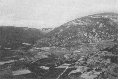
Figure 33.
Valley of the Muses: view southwestwards into the upper valley, from the Pyrgaki Tower.
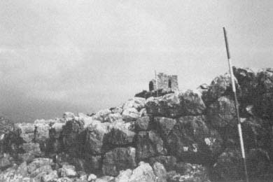
Figure 34.
View of the tower and the outer fortification, on the summit of the Pyrgaki Hill.
of objective light on this quality. Three or four distinct sites were already known in the valley when we came to it: the Sanctuary of the Muses itself, at the head of the more or less level part of the valley shown in Figure 33; the late classical or early Hellenistic watchtower that crowns the hill called Pyrgaki on the north side (shown at the far left of Figure 31, and forming the vantage point from which the photographs in Figures 32 and 33 were taken), and which has usually been taken to be the one mentioned by Pausanias as being the only surviving trace, in his day, of Askra, the home village of the poet Hesiod (Figure 34 shows a closer view of the tower itself); another tower, this time of the Frankish period—probably the thirteenth century of our era—crowning the lower hill called Palaiovoro (Figure 31, center; Figure 32, left); and the church of Agios Nikolaos, high up on the southern side of the valley, where in 1806 Leake found and copied an important inscription about the athletic festival associated with the Sanctuary of the Muses (IG 7. 1776), which led
him, uncharacteristically, into the error of thinking that the sanctuary itself was there.[8]
One question that we had especially hoped to settle was that of the exact site of Hesiod's village of Askra. It was always hard to believe that the tower on top of the bleak Pyrgaki hill, some 2,150 feet up (Figure 34), marked the site of the actual settlement. It was therefore interesting to find that at the eastern foot of this hill there lay easily the biggest and densest site of our region so far discovered: some twenty hectares in extent, it was far too big to be covered in its entirety by our most intensive procedures and had to be handled by means of a sampling process. Particularly interesting was its chronology: the prehistoric era apart, the earliest sherds from here date to around 900 B.C.; occupation then seems to have been fairly continuous until the earlier Roman imperial age; then there is a gap, corresponding neatly to the time of Pausanias when, in his words, "one tower and nothing more was left of Askra to remember it by." There follows the seemingly inevitable resettlement in the fourth century A.D., continuing into the Byzantine and Turkish periods, before the locality reverted to the cultivation of grain and vines. Nor was this site unusual only in its size: at two periods, the Hellenistic and the Late Roman, we found more or less indisputable evidence that pottery was actually being made here, in the form of "kiln-wasters"—that is, pieces of vessels that were misfired in the kiln and then discarded. Along the southern perimeter, there are also visible what may be the traces of a fortification wall. The area of the site fills most of the dip between the two hills, far left and center in Figure 31.
Another argument that seems to us very persuasive from the point of view of the identification of the site arises from a piece of evidence that has been known for over 120 years, and has not prevented some scholars from looking for the site of Askra some
[8] W.M. Leake, Travels in Northern Greece , vol. 2 (1835), 492–93.
miles away. A bare kilometer to the west of the edge of our large site, there lies a much smaller one ("Valley of the Muses 27"), occupied at some of the same periods and marked, at a much later date, by a chapel of Agios Loukas. Here in 1860, in or beside the then still standing chapel, was found part of a Roman inscription, the epitaph for a young girl (IG 7. 1883), the closing lines of which (IG 7. 1884) had been discovered even earlier at the same spot.[9] A poem in elegiac couplets is put in the mouth of the dead girl, and the now completed text included the phrase "The Askraian plain covers me." This is, of course, a poetic expression, but it seems perverse to take the words in any sense other than that this district, at least in the later Roman period, went by the name of Askra—especially now that we know that the find spot is a genuine ancient site, perhaps an outlying graveyard for the main town nearby.
Our site, therefore, seems almost certainly to be that of Askra, the village to which Hesiod tells us his father migrated from Ionia (Works and Days 639–40). It has become common in recent years, and justifiably so, for critics to look askance at what purport to be autobiographical passages in the early Greek poets.[10] In this case, we can at least say that the association between Hesiod and Askra had become established fairly soon after the poet's lifetime, for Plutarch (Moralia fr. 82) tells us, attributing the information to Aristotle, that on one occasion the inhabitants of Askra fled to Orchomenos, taking with them the bones of Hesiod, which had originally been buried elsewhere but later repatriated to Askra. This episode thus cannot be dated later than the lifetime of Aristotle, and the reburial of the bones must, of course, have been earlier still. The chronology of our site shows
[9] See A.M. Snodgrass, "The Site of Askra," in La Béotie antique (Colloques internationaux du CNRS), ed. G. Argoud and P. Roesch (Lyon, 1985), 87–95.
[10] See, for example, M. Griffith, "Personality in Hesiod," Classical Antiquity 2 (1983): 37–65.
that, if it was Askra, then it was already an established place by the time Hesiod's father came (in the eighth century B.C.). The evidence also implies that, at least in later periods, it became a substantial enough place to manufacture its own pottery—incidentally recalling another Hesiodic phrase, "Potter begrudges potter" (Works and Days 25); and in general it offers a plausible setting for those passages in the Works and Days that suggest that their author lived in, or at least frequented, a sizeable village (e.g., 343–47, 493–94). The site shows a period of apparent desertion just when Pausanias says that Askra was deserted, and it is dominated by a tower that conforms well enough to Pausanias's reference to the tower, in the general vicinity of Mount Helikon, that marked Askra. Its location, in the midst of a sea of vineyards, even throws some dim light on a passage of Strabo (9. 2.35): the geographer, discussing a variant reading in the Homeric Catalogue of Ships, "Askra rich in vines," is trapped by his reliance on secondhand evidence into the mistaken view that this would give the place an inappropriate epithet. In fact, firsthand familiarity with the district, and even perhaps with the text of the Works and Days (especially 609–14), might have given him a better basis on which to found his opinions. One thing that we have conspicuously failed to do is to account for Hesiod's disparagement of his family's adoptive home (Works and Days 639–40): certainly Askra, like many places at nearly 1,500 feet above sea level, does not have a gentle winter climate; but his next phrase, therei argaleei , often translated "sultry in summer," and certainly pejorative in general sense, remains entirely obscure to us and may tell more about Hesiod (or about his chosen persona) than about Askra.
In this selection from the findings of our survey, I have passed over many important matters, both of detail and of principle; but it may give a preliminary basis on which to assess the whole method of archaeological survey and its potential contribution. Survey is sometimes dismissed as an activity essentially both an-
cillary to excavation, and parasitic upon it. How far can our findings stand without the excavation of one or more of our "sites," in order to test our interpretation of them—particularly that of the numerous isolated rural "farmsteads"? How could we begin to determine their chronology, were it not for a century or more of prior excavation work that has established the dating of the Greek pottery styles? Would we not in fact have discovered much more of value had we spent the past five seasons excavating a single Boeotian site?
Let me try to offer some sort of answer, beginning with this last question. If we had indeed been excavating, say, a rural settlement for five years, we should have discovered more and better-preserved finds; of that there is little doubt. But would this material have told us anything about anywhere beyond the site itself, in return for the greater demands that it would have made on the precious space in Thebes Museum? The notion that the excavation of a single site will convey information about the region of which that site formed the center is widespread among archaeologists, as countless statements in their writings show; in many cases, its status is that of an unspoken assumption. The more important the site, the larger the area over which it is likely to have exercised control, and of which therefore its finds are usually taken to be representative. Yet how valid is this whole notion? I would venture to suggest that it is really a kind of archaeological convention: a device of convenience, adopted in tacit recognition of the fact that it is not normally possible to excavate even a representative sample of the region, let alone the region en bloc. If the chosen site was in some sense the political capital of a block of territory, however small, then of course the claim of the finds to speak for that territory is slightly reinforced, but even then the scope of the representation is strictly limited. The reality of excavation, which is also very seldom explicitly recognized, is that few sites will in any case be uncovered in their entirety; as we saw from the examples quoted at the end of chapter 2, exca-
vation resembles survey in that it habitually involves processes of sampling, and of extrapolating from the investigated fraction to the whole unit. The main difference between the two is perhaps that, when the unit is a site under excavation, the choice of that sample is more likely to be constrained by fortuitous external factors, such as the position of modern buildings or the availability of land for purchase.[11]
By contrast our findings, if they tell us anything, are telling us about a region: arguably, if the sample has been well or fortunately chosen, quite a sizeable region of Boeotia; but if not, then just the smaller area that has actually been surveyed. This is a stretch of land in which, at times, a number of people may have lived, and in which, beyond doubt, a very much larger number of people obtained their main livelihood, over very long periods. A density map of the finds observed over one part of that area, like Figure 30, is conveying a body of evidence that can be checked and reinvestigated at the most fundamental level, as well as reinterpreted or merely extended.
It is also a body of evidence that one can hardly imagine being assembled through excavation—which brings us to another of the questions posed just now, about the need for validating our conclusions by means of test-excavation of one or more of our sites. A persuasive case could be made for just such a procedure. The careful and total excavation of just one "farmstead" site would, for instance, be invaluable as a test of how far the significant periods of occupation coincided with those conspicuously represented in the surface finds. But as a test of our interpretation of the function of the whole class of such sites, it would be less decisive: the process would really need to be extended over a
[11] These and other issues have been aired by J. F. Cherry in "Frogs Round the Pond: Perspectives on Current Archaeological Survey Projects in the Mediterranean Region," in Archaeological Survey in the Mediterranean Area , British Archaeological Reports, International Series, no. 155, ed. D. W. Rupp and D. Keller (Oxford, 1983), 375–416, and in his subsequent exchanges with R. Hope Simpson in JFA 11 (1984): 115–20.
larger number of sites that were similar in respect of their surface traces. Even then, it would by no means follow that the issues left in doubt by the survey would be settled by the excavation. The distinction between seasonal and permanent human occupation, after all, is one that requires some sophistication in the analysis even of excavation finds. At all events our present intention, though posterity may judge it to be misguided, is to see how far knowledge can be advanced by surface study alone. Though we admit the likelihood that excavation would add a degree of certitude to our findings, we are even more aware of the need for survey to prove itself, at least in the classical context, as a viable branch of independent research.
The charge of parasitism is indeed directly raised by the remaining question asked just now: are we not entirely dependent on earlier excavation work for the whole chronological system within which we operate? Here again, there is no harm in frankly admitting our debt; but it is a debt to the entire range of existing archaeological studies. The dating of the Greek pottery styles, as a matter of historical fact, has been established as much, or more, by stylistic analysis as by stratified excavation finds. At some points, indeed, excavators may find themselves as dependent on this rich seam of traditional research in classical archaeology as surveyors. All our efforts should ideally be seen as complementary.
I have argued in this chapter that, in the task of understanding and explaining the classical past, survey offers an entirely fresh and potentially valuable dimension. It is a dimension that brings out very clearly another relationship, emphasized in some recent nonclassical work, but previously much neglected: I mean the relationship of the archaeological record to the present day. "The archaeological record," writes Lewis Binford, "is here with us in the present. . . . and the observations we make about it are in the
here and now"; they are "not 'historical' statements."[12] The truth of this observation is perhaps more apparent to the surveyor, painfully conscious of the vulnerability of his raw data to the effects of seasonal, even ephemeral, modern activity, than it is to the excavator; for we all share to some degree the illusion that a progress downwards into the earth is a journey backwards into the past. It is not: the stratified deposits uncovered by the excavator all began their existence as surface deposits, for however fleeting a period, and were thus subject to some of the processes of degradation, displacement, and dispersal for which the data of surface survey are often criticized; not to mention the multifarious effects of "post-depositional" factors once these deposits disappeared from sight. There is perhaps a certain monitory value in a method that starkly exhibits these limitations.
In our particular case, the contribution that we believe ourselves to be making to the history of Boeotia is certainly not to a history conceived in traditional terms; but it is to a kind of history that more and more historians today are accepting as a worthwhile aim. In particular, to recover any small part of the history of the rural landscape of ancient Greece will be to break almost entirely new ground—as well as giving new force to the inscription on Hilgard Hall.
[12] L. R. Binford, In Pursuit of the Past (London, 1983), 19, 23.