Accelerated Erosion Caused by Man
Since 1885 normal erosion along all drainage avenues has been drastically altered by man. Railroad trestles were built across canyons as early as 1885, but they did not alter the drainage patterns as far as we can tell. The construction of Highway 101, from 1912 to 1918, first altered the natural drainage patterns with the installation of culverts under the highway to channel surface runoff. In the wet years that followed, gully erosion accelerated where culverts concentrated water flow. In the early 1960s, still larger drains were installed under the new Interstate 5. These drains concentrated surface runoff from numerous drainage avenues, channeling it parallel to the highway and then west, under the highway and railroad tracks. There were no severe wet years following the completion of Interstate 5 until 1978, when rainfall was above average and was more concentrated than usual from January to April, and headward erosion along the altered drainage avenues greatly accelerated. The following are some of the
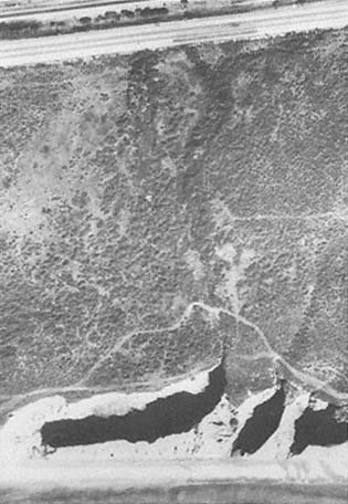
Figure 17a
Vertical photo of the canyon along the bluffs at San Onofre
State Park, 1969. The arrow points to the canyon head.
Photo : U. S. Navy.
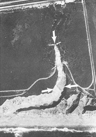
Figure 17b
March 1980 vertical aerial photo showing the development of
a 460-foot canyon perpendicular to the shoreline. It was
extended 235 feet on 20 February 1980 alone.
Photo : U. S. Navy.
more drastic results of this engineering practice.
At Horno Canyon the southbound lanes of old 101 collapsed, leaving a seventy-five-foot deep scarp. At one location, no canyon with an axis perpendicular to the shoreline existed prior to the 1969 storms (fig. 17a ). Sometime between 1968 and 1976, a new canyon was cut perpendicular to the shoreline, about 60 feet headward. Then in January and February 1978 approximately 160 feet of headward erosion occurred, and on February 20, 1980 alone, the canyon eroded another 235 feet landward; this new canyon was 50 to 100 feet deep and 60 to 90 feet wide (figs. 17b and 17c ).
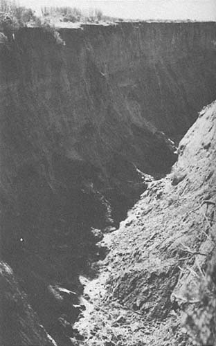
Figure 17c
February 1980 view of the canyon cut into the unconsolidated
colluvial bluff forming terrace deposits at San Onofre State
Park. The evening after the canyon was cut, a park ranger
nearly drove his jeep into the new canyon just before
dark, since it had not been there the previous night.
Photo : G. Kuhn.
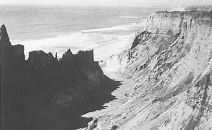
Figure 18
January 1983 view looking down the newly formed canyon, showing how the
sand from the offshore bars has moved onshore to form a wide, new beach.
Dead Dog Canyon, south of Horno Canyon on Camp Pendleton, eroded approximately 560 feet headward between 1932 and 1977. During a two-week period in January and February 1978, this same canyon eroded another 100 feet, and approximately 100 feet more in February 1980. These are just two examples of man-induced erosion which have occurred during the wet years.