Study Area
Dog Island, or Walton's Pasture, as it was known in the early days, has long been a favorite picnic spot for the people of Red Bluff. Now a small island in the Sacramento River, the site's amenities included an area of still water, where the land sloped gently to the river, in contrast to the high, steep bluff for which the city is named. Here the city had its waterworks, which originally consisted of a horse and wagon delivering water door to door. Later, the city pumped water directly from the river, and still later from deep wells.[3] Here also, local youths spent their days cutting school classes, and in the early days this is where most of the local people learned to swim.
In the mid-1960's the area was donated to the city of Red Bluff by the Samuel Ayers family for use as a city park and natural area. The city has kept development at a fairly low level, with a footbridge to the island, a parking lot
[1] Paper presented at the California Riparian Systems Conference. [University of California, Davis, September 17–19, 1981].
[2] Stephen A. Laymon is a Graduate Student in the Department of Forestry and Resource Management, University of California, Berkeley.
[3] Walton, T. 1956. Tehama County centennial oral history interview. Tehama County Library oral history tape.
with landscaping, two restrooms, and trails. One loop road which was put in on the mainland portion has since been closed to vehicles due to a high level of vandalism.
The origin of the name Dog Island remains a mystery since long time residents say that the area was always called Walton's Pasture, and that the dairy cattle from Walton's Dairy on the bluff to the south grazed there. One story has it that an old man ran a kennel on the island in the 1880's, but since no island existed at that time, this is impossible. A more plausible explanation is that park officials asked some local truants what they called the area and "Dog Island" was the answer.
Landforms and Topography
The Dog Island study area consists of the river, the island, the channel around the island, the mainland plain, the red bluff, Brewery Creek, and the gently sloping area from the parking lot to the footbridge (see fig. 1). The entire study area has a remarkably narrow elevation range, with 95% lying between 77.1 m. and 79.2 m. above sea level. On the northwest side, the red bluff known as Duncan Hill rises almost vertically to a height of 97.5 m., or 20.4 m. above the river level. The parking lot at the west edge of the area is between 82.3 and 85.3 m. elevation. From there the land slopes in two terraces to the side channel 76 m. away. The highest point on the island is not more than 3 m. above the gross pool level of the Red Bluff diversion dam.
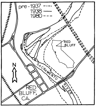
Figure l.
Map of Dog Island study area and environs.
Despite having such a narrow elevation range, the area is not level, having many channels which have waterflow during flood stage. The three most prominent are old river channels that have been silted in over the years. One of these lies east of the bluff near the north boundary of the park, and was the 1850 river channel. Another lies near the east end of the footbridge. The third is found on the southeast side of the island, and was the main river channel prior to the 1937 flood.
The Sacramento River at Dog Island ranges from 170 m. to 250 m. in width. As a result of the diversion dam below Red Bluff, it is kept at a constant 77.1 m. above sea level. This is 2.4 m. higher than the river level would be without the influence of the dam. The water level is lowered slightly to 76.5 m. in the winter when no water is being diverted for irrigation. During flood stage the waters at times rise to 81 m. covering the entire area except the bluff and the parking lot. The river channel that separates the island from the mainland ranges in width from 20 m. to 41 m.
Brewery Creek is an intermittent stream which flows into the study area from the west. It was named for the brewery which was located along it near here in the 1880's. The creek has two main branches, the longer of which is 4.8 km. in length. It drains 8–10 km2 of highly eroded impermeable soils. During heavy local rains the runoff is great and the creek runs high, carrying with it heavy bedloads of rock, gravel, and soil. This is building up a delta in the side channel which may in the future connect the island to the mainland. The creek has cut a deep channel on the north side of the parking lot, and is responsible for the gently sloping gap between the red bluffs of Duncan Hill to the north and the city to the south.
Soils
Soil is the base for the vegetation of any area. Ninety percent of the soils in the study area are fertile loams, so the dense vegetation found here is not surprising.
Five types of soils are found on or near Dog Island. The island itself is an alluvial soil known as Red Bluff loam. It consists of up to 15% gravel, and has both high available water and high moisture-holding capacity (USDA Soil Conservation Service 1967).
The low area to the north of the island is made up of the Columbia loam complex, ranging from mixed soils of silt and gravels to fine sandy loams. These soils generally lie above all but the highest floods, are well drained, and have moderate permeability. They are brown to pale brown in color and are neutral to slightly acid. These are very fertile soils, favored for farming (ibid .).
The soil in the sloping area to the south of Brewery Creek is an Arbuckle gravelly loam. It
is an easily channeled soil with poor waterholding characteristics, very slow permeability, and a clay substrate (ibid .).
Duncan Hill, the bluff on the northwest side, is made up primarily of Newville gravelly loam. This soil is yellowish-brown on the surface and is slightly acidic. The subsoil is a reddish-brown gravelly clay. It is made up of sediment from conglomerate and silt stone of the Tehama formation. In addition, a portion of the hill consists of a mixture of Corning-Redding gravelly loams, a medium acidic, reddish-brown soil with a red clay subsoil. This soil has low permeability and high runoff (ibid .).
Vegetation
The vegetation-types that are found in the study area are floodplain riparian woodland, blue oak woodland, cattail marsh, and landscape plantings. Of the aforementioned vegetation-types, the latter three are the least important since they form such a small portion of the total area. The blue oak woodland found on the hill north of Brewery Creek covers only 1% of the land area. Scattered blue oaks (Quercusdouglasii ) form the canopy here, reaching up to 10 m. There is no understory, and the shrub layer consists of scattered buckbrush (Ceanothuscuneatus ). The groundcover primarily consists of introduced grasses.
The landscape plantings are found around the main parking lot, restrooms and waterworks facilities. They consist mainly of several introduced cedars and pines, a border of live oaks (Quercus sp.) along the highway, several pyracantha (Pyracantha coccinea ) hedges, scattered introduced flowering shrubs, and approximately 0.25 ha. of lawn. These are planted around several native blue oaks.
The two marsh areas are the most important of the minor vegetation-types. They cover about 1% of the area. The marsh on the southern part of the island has a thick growth of cattail (Typha sp.) with a border of willows (Salix spp.). The water is up to 0.3 m. in depth at this spot. The open areas of water are thick with small aquatic plants such as duckweed (Azollafiliculoides ). The land area around the pond that is not covered with cattail and willows is grown up with dense stands of grasses. The marsh on the mainland is just north of the mouth of Brewery Creek. It is higher than river level and only contains water after a flood or heavy rain. The cattail here is much more scattered and intergrown with grasses, herbs, shrubs, and willows, a pattern that has accelerated over the past seven years.
The primary vegetation-type in the study area is riparian woodland. Various forms of this plant community cover 95% of the land. It is an exceptional vegetation-type in the arid West. The riparian vegetation in the study area is quite diverse. Various species of trees are dominant on different portions of the area, often forming stands of clumps or bands of a single species. The western border of the island, facing the slough, is primarily old-growth cottonwood (Populusfremontii ) reaching 40 m. in height, with scattered willows (fig. 2). An understory of box elder (Acernegundo ), willows, black walnut (Juglanshindsii ), and elderberry (Sambucusmexicana ), and bands of shrubcover and groundcover layers of wild blackberry (Rubusursinus and R . vitifolius ), and the introduced Himalayan blackberry (R . discolor ) are found. The central part of the northern third of the island is the most open. It has a cottonwood canopy with a scattered understory of box elder, valley oak (Quercuslobata ), blue oak, and buckeye (Aesculuscalifornica ), and a groundcover of mugwort (Artemisiadouglasiana ) sometimes reaching 2.5 m. The northern tip of the island is a white alder (Alnus rhombifolia ) and willow thicket with no groundcover, surrounded by a blackberry thicket. The northeastern side of the island also has a cottonwood canopy with an understory of box elder, willow, and elderberry, and a shrub and groundcover of blackberry and herbaceous growth. The border of vegetation closest to the water is a dense mixture of white alder, Oregon ash (Fraxinuslatifolia ), and willows. Further south this band of alders and willows widens to about 30 m.
Cottonwoods are absent from the southeast quarter of the island. This area has a very dense canopy of alder, box elder, and willow reaching to 15 m. The trees are closely spaced, allowing very little light penetration. Groundcover is lacking in the thickly forested areas, but bands of blackberry and herbaceous growth are found in the more open spots. One alder thicket of almost 0.75 ha. is especially interesting; the trees have grown to 18 m. and many are now dying. There is no groundcover, but an understory of sycamores (Platanusracemosa ) and Oregon ash is developing. At the southern tip of the island there is a willow thicket reaching 8 m. in height and 30 m. across.
The vegetation on the mainland, south of Brewery Creek, is similar to the western part of
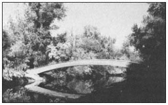
Figure 2.
Footbridge to Dog Island showing dense vegetation
along side channel, looking north (August, 1979).
the island, with a cottonwood canopy to 40 m., a well-developed understory of box elder, alder, and willow, and a groundcover of blackberry. This type of growth also extends along the northwest side of the slough, from 50 m. north of Brewery Creek to the freeway bridge. Also found in this area, in the slightly lower and more open spots near the slough, are several dense willow thickets reaching 7 m. in height and up to 30 m. across.
Along Brewery Creek the vegetation also has a canopy of scattered cottonwoods reaching 25 m., but the understory is much less typically riparian, with live oaks, blue oaks, toyon (Heteromelesarbutifolia ) mixed with the willows, Oregon ash, and box elders. The groundcover is a mix of grasses, blackberries, and herbaceous growth.
Black walnut is the dominant tree in the area just north of Brewery Creek and along the base of the bluff. The trees are not large, reaching only 20 m., and do not form a closed canopy. This allows light penetration and the formation of a dense ground layer of blackberries with patches of willows and elderberries. Also in this area are a number of introduced species such as mulberry (Morus sp.), black locust (Robinia pseudoaccacia ), osage orange (Maclura pomerifera ), plum (Prunus sp.), fig (Ficus carica ), and pyracantha.
At the north end of the bluff the dominant tree species is valley oak. The largest of these trees reaches 35 m. in height, and some are at least 100 years old. This site has a groundcover of grasses and a scattered understory of box elder and black walnut. The valley oak area borders the field to the north for about 300 m. and merges into an area with a canopy of black walnut and cottonwoods. In this location there is also a dense osage orange thicket of about 1 ha. which is devoid of groundcover.
The center of the mainland portion is the most open of the entire study area. Until 1975 it was a large, grassy meadow with a few scattered clumps of box elder, plum trees, and two dense box elder thickets. When the park loop road was constructed, the grass in the meadow was mowed to cut down on fire danger and provide a more "park-like" atmosphere. The meadow instantly became a defacto parking lot, the gathering place for the local teenagers, which totally denuded large areas of it. Due to reduction of competition from the grasses, the box elders began to grow rapidly and now are large trees reaching 15 m. and covering a much more extensive area. The tall rye and Johnson grasses that previously covered the meadow provided a vegetation-type that is now missing. More information on this area can be found in Laymon (1983).