Net Fill and Scour
Minimal spawning or rearing habitat was available in the upper Carmel channels during the period of maximum fill. Habitat availability increased as the stored sediment was gradually scoured. A useful measure of these sequential changes is net mean fill or scour, determined from the change in mean bed elevation of the channel during each storm period. This change was quantified using repeated level-surveys of monumented cross-sections.
The sequence of fill and scour was recorded at six cross-sections in three riffles. The riffles were chosen shortly after the fire on the basis of observable habitat values for both spawning and rearing, their general alluvial character, absence of major unusual hydraulic properties, and presence in a long and straight reach. The last three criteria were necessary to meet the hydraulic requirement of the indirect discharge measurements used to determine the peak flows during each storm period. The sections were established in early November, 1977, fol-
[4] Bloyd, R.M. 1981. Letter of March 18 to Robert F. Blecker, hydrologist for Los Padres National Forest, which summarizes USDI Geological Survey studies of post-fire sedimentation in Los Padres Reservoir.
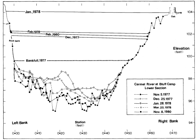
lowing the fire but prior to any measurable runoff. Cross-sections were resurveyed after each significant flood event during the winter of 1977–78, and again following the wet season of 1979–80. An example of data collected at one section describing the sequential changes in elevation and configuration of the bed is presented in figure 2.
The fill and scour cycle observed at each riffle is summarized in table 3. Fill occurred immediately after the first storms in December, 1977, and continued at some sections through the major storm period in January, 1978. By the end of the first winter, the bed was being scoured at all six sections, a process which continued through the second and third rainy seasons. The final column in table 3 traces the proportion of maximum net fill removed during each period.[5] By the end of the first season, 57–102% of the maximum observed net fill had been scoured. "Recovery percentages" of 80–151% were recorded by the end of the third year. At four of the six sections, 80–90% of the maximum observed fill had been removed by the end of the third year. Mean scour exceeding the mean maximum fill was limited to the riffle at Carmel Camp, where about half of the mean scour is attributable to lateral erosion of the lower bank area on one side of the channel.

Figure 2.
Bed configuration and high-water marks during the fill and scour
cycle following the Marble-Cone fire, looking downstream.
Some high-water profiles slope toward the right bank, discussed below in the text.
[5] Maximum fills may have been greater during one of the storm periods. Ephemeral bed conditions during storm crests may not have great importance in defining spawning or rearing habitat value; thus the methodology is appropriate for the purposes of this study. The reader is cautioned that recovery percentages in table 3 may underestimate the removal of within-storm fill maxima.
| ||||||||||||||||||||||||||||||||||||||||||||||||||||||||||||||||||||||||||||||||||||||||||||||||||||||||||||||||||||||||||||||||||||||||||||||||||||||||||||||||||||||||||||||||||||