Sequential Changes in Bed Habitat Conditions in the Upper Carmel River Following the Marble-Cone Fire of August, 1977[1]
Barry Hecht[2]
Abstract.—Runoff following a major fire filled the upper Carmel River, Monterey County, California, with sediment. Repeated measurements of four habitat descriptors were made in riffles during three years following the fire. Habitat values were largely restored by the end of the first winter, with virtually complete recovery after three years.
Introduction
The importance of episodic or unusual events in the management of riparian systems in montane areas is increasingly being recognized. Wildfires are one of the major recurring disturbances affecting biologic and geomorphic processes in these watersheds. This is especially true in basins with significant areas of steep, chaparral-covered slopes.
Many resource managers consider the canyon bottoms—the channels, riparian zones, and valley flats—the most biologically significant zones in these watersheds. The bottomlands commonly remain unburned during fires which otherwise affect much of the drainage area. The primary physical changes in these corridors are frequently those associated with erosion, deposition, and channel instabilities induced by post-fire storm runoff. While numerous studies of fire-related increases in runoff and debris load have been made, relatively little is known of their effects on habitat values.
This report is a preliminary summary of an ongoing study addressing one aspect of the larger management problem—the indirect effects of fires on bed conditions affecting aquatic habitat values. The upper Carmel watershed in Los Padres National Forest, Monterey County, California was chosen for this study for three reasons. First, the drainage is used primarily for recreational, habitat, and watershed purposes; the alluvial corridor is central to all three uses. Second, direct human disruption of soil and vegetation in the basin is minimal, limited primarily to ridgetops far removed from the channels. Third, the watershed is in the size range of smaller basins capable of sustaining an anadromous fishery commonly considered to be from about 10–100 km2 (4–40 mi2 ).
There were two significant limitations on this study imposed by the choice of the upper Carmel watershed. First, there are no stream gauges in the basin. Synthesis of a flow-record for each site will be required to establish the relationship of the observed sequential changes to runoff. Data needed to develop the synthetic flow-record are presently not fully available. Secondly, access to the sites required a hike of about 8 km. (5 mi.) over damaged trails with backpacks and survey gear, limiting both the equipment which could be used and the number of sites which could be monitored during a given weekend.
Regional Setting
The Carmel River drains the northern slopes of the Santa Lucia Mountains (fig. 1). The upper portion of the basin is a rugged area of approximately 161 km2 (62 mi2 ) above Los Padres Dam, a municipal water-supply source for the Monterey Peninsula urban area about 50 km. (30 mi.) to the north.
The watershed is underlain by faulted crystalline rocks, primarily schists, gneisses, and metasomatic granitic rocks ranging in composition from granodiorite to gabbro (Wiebe 1970). Weathering of these rocks produces a large amount of medium-grained sand and a disproportionately small percentage of fine gravel. The courses of the main channels are structurally-controlled, primarily by faults and fractures. The channels are unusually steep for watersheds of comparable size in the region.
[1] Paper presented at the California Riparian Systems Conference. [University of California, Davis, September 17–19, 1981].
[2] Barry Hecht is Senior Hydrologist, HEA, a Division of J.H. Kleinfelder and Associates, Berkeley, California.
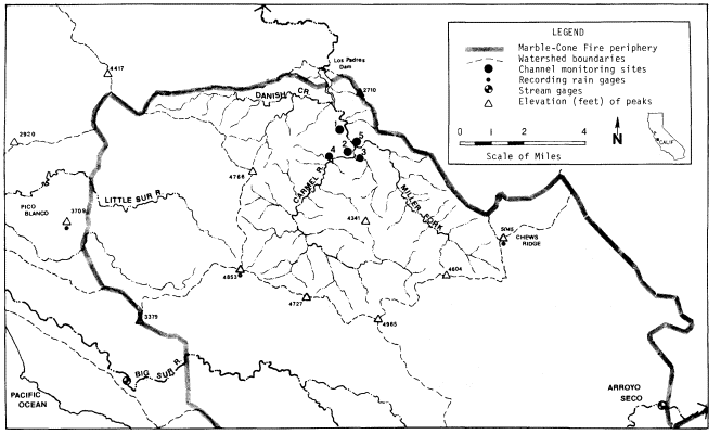
Figure 1.
Upper Carmel watershed and vicinity. Monitoring sites on the Carmel River are at Bluff Camp (1), Carmel
Camp (2), below Bruce Fork (3), at Sulphur Springs Camp (4), and on Miller Fork above its mouth (5).
Rainfall ranges from an average of 610 mm. (24 in.) per year at Los Padres Dam to an estimated 1150–1270 mm. (45–50 in.) at the drainage divide with the Big Sur watershed. This supports a vegetative mosaic with chamise/chaparral on steeper exposed slopes, oak/madrone woodland community on more protected slopes and terraces, and mixed hardwood/coniferous forest at the highest elevations.
The Marble-Cone Fire
The Marble-Cone Fire burned approximately 72,000 ha. (178,000 ac.) in the Santa Lucia Mountains during August, 1977 (fig. 1). Virtually all of the Carmel watershed above Los Padres Reservoir was affected by the fire. The USDA Forest Service staff estimated remaining canopy cover to be less than 10% in 42% of the upper Carmel basin; 11–50% over an additional 20% of the watershed; and more than 51% over the remaining 38% of the area.[3] No extensive fires had occurred in the watershed during the previous 50 years. Much of the basin had remained unburned for 76 years or more (Griffin 1978).
Two unusual occurrences contributed to the severity of the burn, and particularly to its impact on the canyon floor areas. Fuel levels were abnormally high due to an extreme amount of limb breakage sustained during a wet and sticky snowfall on January 3, 1974. The effect on fuel loadings was especially large in the riparian zone and on the terraces and lower slopes, areas seldom affected by snowfall. Secondly, conditions were also unusually dry following the severe drought of 1976 and 1977. Rainfall at Big Sur, the nearest long-term station, during each of these years was less than that measured for any of the previous 58 years.
Post-Fire Runoff
Rainfall during the 1977–78 and 1979–80 winter seasons was 40–50% above normal at many stations in the region; rainfall during 1978–79 was generally slightly below average. Runoff in the Carmel and nearby watersheds was markedly above normal during this 3-year period, reflecting both the above-average rainfall and the altered runoff characteristics (table 1). The duration of high flows was also much above normal. One measure of this duration is the number of days that flow exceeded bankfull conditions. In the Monterey Bay area (as in many other regions), this corresponds roughly to the flood with a recurrence of 1.5 years. The Big Sur River is the nearest gauged stream, and is consi-
[3] USDA Forest Service. Undated. MarbleCone fire: remaining vegetative cover. Unpublished staff report. Los Padres National Forest.
sidered most representative of the upper Carmel River. The 1.5-year flood discharge on the Big Sur River is approximately 1,600 cubic feet per second (cfs). Based on preliminary records, this discharge was exceeded for a total of about 10 days in 1978 and about 6 days in 1980, compared with an annual average of 1.1 days for the period prior to the fire.
| ||||||||||||||||||||||||||||||||||||||||||||||||||||||||||||||||||||||||||||||||||||||||||
More specific data are available on the effect of the fire on sediment yields of the upper Carmel watershed (table 2). Deposition in Los Padres Reservoir during the three years following the fire was about equal to that during the previous 30 years. In addition, a large but undetermined amount of debris has accumulated in the channels of the Carmel R ver and Danish Creek above the spillway elevation.[4]
| ||||||||||||||||||||||||||||
Sequential Changes in Bed Habitat Conditions
Habitat in the streams of the upper Carmel system is generally evaluated by its suitability for salmonid production. The local resource includes both steelhead and resident trout. Availabilities of suitable spawning and rearing habitats are considered factors limiting both populations, a common situation in streams of central California.
In riffles of boulder-bedded streams such as the upper Carmel River, both spawning and rearing occur in spaces or openings between the larger bed-forming rocks. Spawning occurs in bars and accumulations of gravels which form between the boulders or in their lees, locations partially protected from scour.
The epicycle of massive fill and scour following fires in this environment temporarily buries most of the limited habitat with finer material, largely sand. For this reconnaissance study, descriptors chosen to define the extent of burial and subsequent uncovering of habitat include:
1. net fill and scour, as measured by level-surveys following each major group of storms;
2. particle-size distribution of the bed surface, measured by censusing particles at the intersections of a grid;
3. percentage of bed area occupied by sand and finer material, also sampled on a grid; and
4. percent of the bed covered by material of sizes suitable for spawning, determined as above.
Net Fill and Scour
Minimal spawning or rearing habitat was available in the upper Carmel channels during the period of maximum fill. Habitat availability increased as the stored sediment was gradually scoured. A useful measure of these sequential changes is net mean fill or scour, determined from the change in mean bed elevation of the channel during each storm period. This change was quantified using repeated level-surveys of monumented cross-sections.
The sequence of fill and scour was recorded at six cross-sections in three riffles. The riffles were chosen shortly after the fire on the basis of observable habitat values for both spawning and rearing, their general alluvial character, absence of major unusual hydraulic properties, and presence in a long and straight reach. The last three criteria were necessary to meet the hydraulic requirement of the indirect discharge measurements used to determine the peak flows during each storm period. The sections were established in early November, 1977, fol-
[4] Bloyd, R.M. 1981. Letter of March 18 to Robert F. Blecker, hydrologist for Los Padres National Forest, which summarizes USDI Geological Survey studies of post-fire sedimentation in Los Padres Reservoir.
lowing the fire but prior to any measurable runoff. Cross-sections were resurveyed after each significant flood event during the winter of 1977–78, and again following the wet season of 1979–80. An example of data collected at one section describing the sequential changes in elevation and configuration of the bed is presented in figure 2.
The fill and scour cycle observed at each riffle is summarized in table 3. Fill occurred immediately after the first storms in December, 1977, and continued at some sections through the major storm period in January, 1978. By the end of the first winter, the bed was being scoured at all six sections, a process which continued through the second and third rainy seasons. The final column in table 3 traces the proportion of maximum net fill removed during each period.[5] By the end of the first season, 57–102% of the maximum observed net fill had been scoured. "Recovery percentages" of 80–151% were recorded by the end of the third year. At four of the six sections, 80–90% of the maximum observed fill had been removed by the end of the third year. Mean scour exceeding the mean maximum fill was limited to the riffle at Carmel Camp, where about half of the mean scour is attributable to lateral erosion of the lower bank area on one side of the channel.
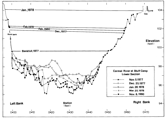
Figure 2.
Bed configuration and high-water marks during the fill and scour
cycle following the Marble-Cone fire, looking downstream.
Some high-water profiles slope toward the right bank, discussed below in the text.
[5] Maximum fills may have been greater during one of the storm periods. Ephemeral bed conditions during storm crests may not have great importance in defining spawning or rearing habitat value; thus the methodology is appropriate for the purposes of this study. The reader is cautioned that recovery percentages in table 3 may underestimate the removal of within-storm fill maxima.
| ||||||||||||||||||||||||||||||||||||||||||||||||||||||||||||||||||||||||||||||||||||||||||||||||||||||||||||||||||||||||||||||||||||||||||||||||||||||||||||||||||||||||||||||||||||
Size Distribution of Bed Material
The particle-size distribution of bed material is commonly quantified in the course of habitat assessments, either by a visual estimate or by a grid-by-number census. The latter approach was used in this study.
Particle-size distributions of bed-surface material were determined by measurement made at the same five riffles in the early fall months of each year, prior to the onset of rains. This is the season in which rearing habitat is most likely to be constrained by sediment. An area-stratified random sample of the entire riffle bed was drawn by stretching cloth measuring tapes between rows of eight to ten iron pins at the top and base of each riffle. Lengths of intermediate axes of particles immediately beneath preselected points on the tapes were measured and grouped in standard size-classes. This procedure is an adaption for use in boulder-bed channels of Wolman's (1954) now-standard methodology. A sample of 50 to 100 rocks is generally considered sufficient to describe bed-surface populations; larger samples were drawn following the 1978 storms as a wider range of size-classes were observed.
Sequential changes in the size distribution of bed material are shown in table 4. Sizes at the key descriptive percentiles generally decreased following the fire, then subsequently have increased. Relative changes were more pronounced at the 16th and 50th percentiles than in the larger materials, as might be expected.
Much, and probably most, of the change in particle-size distribution occurred during the first year following the fire. It was not feasible to recensus the bed between storms due to the unusually high flows of the winter of 1978. In most cases, the minimum sizes probably were associated with the December, 1977, or January, 1978 storm periods. Had no more storms occurred during the winter of 1978, a much greater effect on habitat conditions would have been observed during the summer and fall of 1978.
Sand-Covered Bed Areas
Aquatic biologists have often identified percent bed area covered by sand (or finer material) as a significant influence on the distribution of species in the channel, and as a factor affecting salmonid egg viability. The distribution of sand and finer material on the bed of mountain stream riffles appears to be controlled by different geomorphic processes than those governing the coarser sizes. In this study, sand is considered as a separate population, one whose variability is also best described by the percentage of the riffle bed which it covers. In this study, the sand-and-finer percentage of the bed surface was determined in the course of the particle-size measurements. Intermediate axial lengths of particles smaller than 4 mm. could not be readily measured under field conditions; these were grouped in a single class informally labelled "fines."[6]
[6] Most standard classifications divide sands and gravels at 2 mm. In the upper Carmel environment, which is deficient in very fine gravels, any interpretive difficulty introduced by including 2–4 mm. material with the sands is minor.
|
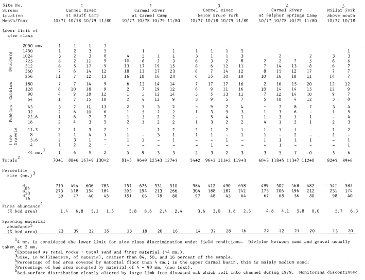
Sequential changes in the sand-covered portion of the bed are shown in figure 3. The abundance of fines increased markedly with the first storms after the fire. At the Bluff Camp riffle, the percentage of bed area covered by sand or finer debris on December 25, 1977, was visually estimated to be 40% in the riffle and 95% in the pool beneath it. By the end of the first year, the fines abundance at the five sites averaged only very slightly greater than at the time of the fire. As with the particle-size changes, the sequential variations in fines abundance were greatly accelerated by the unusually high runoff conditions of the 1978 water year.
Availability of Spawning-sized Material
Salmonid spawning habitat in the upper Carmel watershed may be limited by the availability of material of suitable sizes in riffles. The relative abundance of this material can be quantified for the Carmel channels as the percentage of the bed surface occupied by rocks within the range of suitable sizes, as no appreciable armoring of the bed was observed. For this study, it is assumed that the range of 4 mm. to 90 mm. defines the bulk of material found in and above freshly-constructed redds in streams of comparable size, slope, and underlying rock types (e.g., Orcutt etal . 1968, Platts etal . 1979).[7]
The availability of spawning-size material increased markedly at four of the five riffles in the first year after the fire. The percentage of the bed occupied by this size-range has remained slightly elevated, although depletion has probably occurred since 1978, particularly in the smaller sizes. To an appreciable degree, the increase has been manifested as expanded bars in
[7] Percentages of bed area occupied by material of other ranges may be computed from table 4 by those who would prefer to consider different sizes.
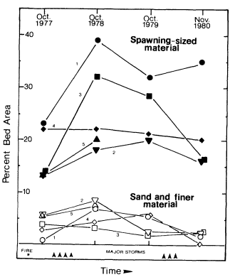
Figure 3.
Sequential changes in bed area occupied by spawning-sized
material and sand-and-finer debris following the Marble-Cone
fire. Runoff events substantially exceeding bankfull discharge
are considered major storms. Sites are numbered as on figure 1
and table 4.
the lees of larger boulders, a location preferentially used for spawning in boulder-bedded channels. The role of fires in the supply of gravels in high-gradient streams merits study.
Supplemental Observations
Other processes related to post-fire sedimentation also affected the channels and riparian corridors. These were observed in a more general way.
1. The fill and scour cycle in pools and glides (or "runs") was greater in absolute magnitude than in riffles. Several traditional swimming holes were completely filled during the December and January storms following the fire. The relative rates of recovery in pools and glides seemed to be similar to or slightly slower than those in the riffles of this boulder-bedded channel.
This study was limited to describing sequential changes in riffles, where indirect discharge estimates and bed-material census are customarily made. Equally important in this decision was the historical emphasis placed on riffles by aquatic biologists. Subsequent research has clarified and quantified the importance of rearing habitat within pools and glides in salmonid production (e.g., Bjornn etal . 1977; Kelley and Dettman 1979). Future studies of post-fire changes in habitat should include pools and glides.
2. Few secondary slope instabilities were induced by the fire. Landslide-related sediment delivery to the main channels was probably of negligible magnitude; this presumably contributed to the rapid rate of sediment depletion in the channels. The relative stability of the slopes is considered to be primarily a function of bed-rock type.
3. Interception of sediment on the lowermost terrace was widespread, particularly at the mouths of ravines, chutes, and small tributaries. Much of this material is of gravel or pebble size. Relative to the volume of coarse material deposited in and above Los Padres Reservoir since the fire, the volume of debris intercepted on the terrace was small, perhaps 1–3%. This is a smaller amount, but somewhat similar to the fire-related sediment still stored in the main channels at least above the tailwater areas of Los Padres Reservoir. Delayed delivery of coarse material stored in these debris cones may be a factor in maintaining the supply of spawning-sized material during extended periods between major fires and floods.
4. Floods following the fire removed much of the organic matter which had accumulated in the channel. Most fallen trunks and limbs on or spanning the streambed were dislodged, then either washed through to Los Padres Reservoir or wedged between the trunks of larger riparian trees distributed along the banks. These small debris jams generated significant eddies during flood periods. As an example, the high-water marks of the December, 1977, February, 1978, and February, 1980 floods indicate that the water-surface profile sloped toward the right bank, the result of a small debris jam 12 m. (40 ft.) upstream. Nearly continuous lines of broken twigs and other fine organic matter accumulated in these eddies during each storm. Each line contained an appreciable amount of material, generally 0.5 to 5 cm. thick. Partial incorporation of this material into the soil was clearly visible by November, 1980. Post-fire additions of organic material to soils at or slightly above the active floodplain may be an appreciable factor in the development of soils in the riparian zone.
Conclusions
1. Sequential changes in riffle conditions in the upper Carmel watershed following the Marble-Cone fire were observed using four physical descriptors of salmonid habitat:
a. mean fill and scour;
b. particle-size distribution of the bed surface;
c. percent of the bed surface covered by sand and finer debris;
d. percent of the bed surface occupied by material of sizes suitable for spawning.
2. Riffles in the master channels of the upper Carmel watershed filled up to 0.3 m. (1 ft.) during the first storms following the Marble-Cone fire, primarily with sand. By the end of the first year, most of the fill had been scoured; much of what remained was of pebble and cobble size. By the end of the third year, all descriptors had returned to within 20% (relative to the maximum measured disruption) of their pre-fire conditions. Other on-going watershed processes were probably more important than residual effects of the fire as influences on habitat conditions by the end of the third year.
3. Effects of the fire on runs and pools were not measured. Maximum mean channel fill was generally observed to be several times greater than in riffles. Recovery of habitat values appears to occur at relative rates similar to or slightly slower than those in the riffles.
4. A substantial volume of sediment, primarily gravels and cobbles, was intercepted in the riparian and terrace areas. Delayed delivery to main channels is likely to be an important factor in maintaining the availability of spawning-sized material between major disruptive events.
Acknowledgments
This study was conducted in cooperation with the USDA Forest Service, Pacific Southwest Forest and Range Experiment Station, as part of the Chaparral Management Research and Development Program. Suggestions and assistance were contributed by Wade G. Wells and C. Eugene Conrad of the station; Robert F. Blecker (Los Padres National Forest); Gene H. Taylor (Monterey County Flood Control and Water Conservation District); and Vincent Piro and Randal Benthin (California Department of Fish and Game). Special thanks are extended to friends and colleagues who assisted in the field work, often under wet and cold conditions: Robert Herman, David F. Hoexter, Mark Jansen, G. Matt Kondolf, Yane Nordhav, Mark Springer, and Philip B. Williams. Wade Wells, David Hoexter and Nicholas M. Johnson reviewed the report in draft form.
Literature Cited
Bjornn, T.C., M.A. Brusven, M.P. Molnau, J.H. Milligan, R.A. Klamt, E. Chacho, and C. Schaye. 1977. Transport of granitic sediment in streams and its effects on insects and fish. University of Idaho Forest, Wildlife, and Range Experiment Station Bull. No. 17. 43 p.
Griffin, J.R. 1978. The Marble-Cone fire ten months later. Fremontia 6(2):8–14.
Kelley, D.W., and D.H. Dettman. 1980. Relationships between streamflow, rearing habitat, substrate conditions, and juvenile steelhead populations in Lagunitas Creek, Marin County. Report to the Marin Municipal Water District. 36 p. D.W. Kelley and Associates, Newcastle, California.
Orcutt, D.R., T.R. Pulliam, and A. Arp. 1968. Characteristics of steelhead trout redds in Idaho streams. Trans. Amer. Fish Soc. 97(1):42–45.
Platts, W.S., M.A. Shirazi, and D.H. Lewis. 1979. Sediment particle sizes used for spawning, with methods for evaluation. US Environmental Protection Agency Pub. 3-79-043. Cincinnati, Ohio. 32 p.
Wiebe, R.A. 1970. Relations of granitic and gabbroic rocks, northern Santa Lucia Range, California. Geol. Soc. Am. Bull. 81(1):105–116.
Wolman, M.G. 1954. A method of sampling coarse river-bed material. Trans. Am. Geophys. Union 35(6):951–956.