Part I
Modern and Historical
Migrations
Rather than proceeding chronologically, we shall start with recent cases because in them we can observe the cause and course of migration most clearly. In prehistoric migrations, movement of species borders, changes in dispersal, and even the environment cannot be observed directly, but have to be inferred. I believe background knowledge of relatively clear-cut recent cases will help interpretation of more ancient ones.
Much of the subject matter of recent plant migrations is shared with ecological studies of vegetational succession, but the approaches differ. Succession is usually treated as change in a community as a whole within fixed spatial borders. Both the standard relay floristics model and the initial floristics model of succession usually assume a constant pool of available species, whether the seed source is inside or outside the borders of the study area (Egler 1954; McIntosh 1980). Variations in seed availability are often treated as random complications not covered by the model. The focus here will be on migrations of species individually, with the changing spatial patterns of dispersal and survival treated as integral variables in the process.
1
Shoreline And Other
Naturally Open
Habitats
Mangrove Swamps
By definition, mangroves are trees rooted in substrates that are flooded by seawater, either constantly or periodically. Mangroves belong to many different angiosperm families, some of which also include upland genera, but all the mangrove genera are tightly confined to their saline swamp habitat. Most mangrove genera are tropical, with a minority ranging into the subtropics. Members of the genus Avicennia, a tree belonging to the Verbena family, range farthest into temperate regions. Within their latitudinal limits, mangroves have very broad edaphic and climatic tolerances. Because they are able to draw water molecules and nutrients from the sea, they are remarkably indifferent to substrate, growing in rock crevices and many kinds of sand and mud. Where there is good circulation of seawater, they are also remarkably indifferent to rainfall, growing adjacent to rain forests, deserts, and everything between. Nevertheless, suitable mangrove habitats are extremely discontinuous because of the need of shelter from wave action for seedling establishment.
Within a mangrove forest, species patterns often show striking zonation, which has often been interpreted to be the result of autogenic succession: a pioneer fringe advances seaward, traps sediment, builds up land, and prepares the way for advance of the next zone. However, case histories show the dynamics are usually more complex.
River Deltas, Southern Gulf of Mexico
(Thom 1967; West et al. 1969)
The great uncontrolled rivers of Tabasco and Campeche have provided a dynamic habitat complex in which mangrove distribution patterns are continually changing. In historical time, active river mouths have switched between some distributary channels that fan out over the deltas. During floods, active distributaries build ever higher and wider natural levees along their channels. The sand they pour into the Gulf of Mexico is carried by longshore currents to be laid up by waves as a series of accretion beach ridges parallel to the shore. The constant loading of additional sediment causes regional subsidence of the whole delta. When a distributary is becoming inactive, the old channel is slowly filled with fine sediment deposited by general floods during the winter rains. During the dry season, saline water invades abandoned stream channels and lagoons, and penetration increases during the years as subsidence goes on. Water levels are less affected by the trivial lunar tides than by changes in wind direction, the highest levels coming during coincidence of maximum river discharge and strong north winds during winter. These northerly storms, called nortes, also cause severe beach erosion. After the sand supply has been diverted by a shift in a river mouth, huge areas of beach ridge systems near the abandoned mouth are eventually lost to the sea.
The dominant mangrove species in this region are Rhizophora mangle, Avicennia germinans, and Laguncularia racemosa ; all produce nondormant seedlings capable of long flotation. The mangroves do not colonize natural levees being built by active distributaries; there the first colonists are marsh plants, such as Phragmites, Spartina, and Typna spp. When a distributary is being abandoned and becoming saline, Rhizophora seedlings floating in from the sea usuallv colonize the banks. The tangle of stilt roots of the Rhizophora fringe catches debris and sediment, and the mangroves add organic detritus of their own. As the channel fills and narrows, the Rhizophora fringe widens by establishment of new seedlings, while Avicennia and Laguncularia seedlings join the older Rhizophora in the rear, forming a mixed mangrove forest. As long as peat formation under the mixed mangrove forest compensates for subsidence, the species may persist in situ indefinitely unless the forest is destroyed by retreat of the seashore or is overrun by a new active stream channel.
A different geomorphic—biotic sequence begins on the back side of the natural levees, which slope gradually to mudflats along seasonally saline lagoons. As the mudflats are built up by sedimentation during floods, they are first colonized by Spartina and Batis maritima, a prostrate perennial halophyte. Here Avicennia is usually the pioneer mangrove, with the other
two joining in as sedimentation proceeds. When the distributary becomes inactive and sedimentation is shut off, subsidence will cause the mangrove fringe, with Avicennia in the lead, to move toward the crest of the sinking levee. Lagoons enlarged by subsidence eventually have enough fetch for generation of waves, which undercut the mangroves and wash them away.
Thom (1967) postulated a variety of other geomorphic sequences in this deltaic complex. His general conclusion was that in certain situations, mangroves trap sediment and lay down peat so that vegetationally controlled, autogenic succession may temporarily prevail, but that over the long run habitat changes controlled by the mangroves are overwhelmed by a grand geomorphic cycle controlled by the rivers and the sea.
Coral Cays, Belize
(Stoddart 1962, 1963, 1969)
Mangroves occupy a totally different geomorphic setting on the other side of the Yucatan peninsula, where they grow on coral cays with no river or terrestrial sediments. The cays lie on the barrier reef and on atoll-like structures beyond. The cays most exposed to wind and surf have beach ridges built of coarse coral debris, which are colonized by species discussed in the next chapter. On these exposed cays, mangroves are confined to a fringe on the leeward shore. On more sheltered cays, typically shoals with no dry land, mangroves occupy the whole area. Rhizophora mangle is generally strongly dominant, particularly on the outer margins of the mangrove forest, joined by Avicennia germinans and Conocarpus erectus on slightly higher areas. Laguncularia racemosa occurs infrequently.
Autogenic succession, with mangroves advancing as they trap sediment and lay down peat, cannot be a general process in these cays. Some of the mangrove cays apparently have permanent shorelines with rock foundations rising from fairly deep water. There, mature mangroves grow to the edge with no seedling colonization beyond. Other unconsolidated cays are gradually migrating shoreward; whether they are constant in area, increasing, or disappearing probably depends on the reef flat topography, sand supply, waves, and currents, not on the vegetation.
Catastrophic changes in mangrove patterns were documented by Stoddart's (1962, 1963, 1969) surveys before and after Hurricane Hattie in 1961. His 1960–1961 maps of the cays show vegetation patterns that may have been in approximate equilibrium. Most of the cays had not had a major hurricane strike for 30 years; the southernmost part of the surveyed area may have had hurricane damage 15 years before. The center of the 1961 cyclone passed directly over the cays. Sustained wind speeds were estimated at 250
km/hr with gusts to 320 km/hr. Atmospheric pressure was so low that over an area about 100 km in diameter, the sea rose about 5 m above normal level. Huge waves were superimposed on this storm surge.
The storm broke branches and stripped leaves from mangroves over a wide swath. Stoddart's 1965 resurvey found mangroves were generally dead within a swath about 65 km wide, the only survivors being in very small patches on the leeward sides of the larger cays. Within the dead stands, the ground was still occupied by the old roots and there were a few seedlings. New seedlings were establishing mainly in new bare areas.
Great Barrier Reef, Queensland
(Hopley 1982; Stoddart 1980; Stoddart et al. 1978)
Queensland, Australia, has a much richer complement of mangroves than the neotropics, with 27 species belonging to many different angiosperm families at least locally dominant. All are sea dispersed and shared with the East Indies. With ocean swell shut off by the Great Barrier Reef and a tidal range of 3 to 6 m, mangrove swamps require only minimal topographic shelter and are very extensive.
Within a mangrove stand, species commonly show rather regular zonation, which has evoked deductive models of predictable, autogenic succession. However, where distribution patterns have actually been monitored over time, in some cases by detailed remapping over nearly 50 years, irregular and unpredictable changes were found. Rather than actively advancing by autogenic succession, the mangroves generally passively follow changes in reef morphology with coral growth and destruction.
Naturalized Mangroves, Hawaii
(Wester 1982)
Hawaii is better situated to receive drift from Alaska than from the tropical Pacific. It had no native mangroves, the nondormant seedlings evidently being unable to survive the circuitous voyage up the coast of Asia, across the northern Pacific, and back down to the tropics.
In 1902, the American Sugar Company introduced Rhizophora mangle from Florida to Molokai, Hawaii (fig. 1), where it was planted on the south coast in an attempt to stabilize sediment produced by erosion on the slopes of the island. Seedlings were transplanted from Molokai to Oahu and have since volunteered on the islands of Hawaii, Maui, Lanai, and Kauai, evidently
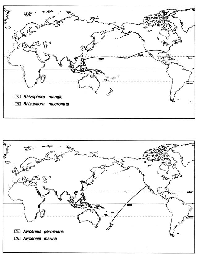
Figure 1. Recent Introductions of Certain Mangroves Outside Their Native Ranges. Mangrove species
generally are well adapted for ocean disposal and have very broad natural ranges. They were, however,
unable to reach some suitable habitats as shown by naturalization following recent artificial introduction.
spreading within the archipelago by natural drift. The neotropical button mangrove, Conocarpus erectus, was also planted in various places along the coast but has not naturalized.
In 1922, four Philippine mangrove species were introduced by the Hawaiian Sugar Planters Association and planted on mudflats around Oahu. Ceriops tagal promptly died; Rhizophora mucronata and Bruguiera parviflora survived for a few years. Bruguiera gymnorhiza has survived and reproduced in several sites on the Oahu coast, in spite of much exploitation of its flowers for leis.
Some of the Hawaiian mangrove colonies depend on artificially modified habitats. The prehistoric rock-walled fish ponds, built in the sea by the Polynesians, offer sheltered habitats for dense mangroves. Mangroves infest canals, including the Ala Wai behind Waikiki, where they must be periodically removed. Extensive stands occupy deltas below sugar mills, where sediment from cane washing is deposited. A 40-acre stand of Rhizophora mangle colonized such a delta in Pearl Harbor between 1951 and 1975. However, other colonies are established on shores naturally sheltered by reefs and embayments. Presumably, these would have been colonized prehistorically if viable seedlings had arrived.
Naturalization of Avicenna, California
(Moran 1980)
Several neotropical mangrove species range naturally up the Pacific coast of Mexico across the Tropic of Cancer. They extend above 29°N latitude in the Gulf of California, but none extend above 27°N on the Pacific side of Baja California.
In 1963, two of these species, Avicennia germinans and Lagunclaria racemosa, were planted experimentally at about 32.5°N latitude in California. The site is a salt marsh dominated by Spartina foliosa on Mission Bay in San Diego. It is administered as a nature reserve by the University of California, San Diego. Neither of these mangroves succeeded, although one Laguncularia survived for several years.
In 1968, seedlings of two Indo-Pacific mangroves were planted in the same marsh: Aegiciras corniculatum from tropical Queensland and Avicennia marina from 37°S latitude in New Zealand. The Aegiciras has survived and flowered but not reproduced. Avicennia marina established thousands of seedlings, now in the third generation; its success threatened the native biota of the marsh. Since 1976, university students have stopped Avicennia reproduction by removal of flowers and seedlings; in 1979 about 12,000 rooted seedlings were pulled up, but a few were left.
Comment
Normal dispersal of mangroves is entirely by ocean currents. Many species are viviparous, that is, seedlings germinate before release from the mother tree and continue to develop while floating. With light, water, and nutrients available, dormancy is pointless. Seedlings occasionally strike root in rock crevices, even on open shores. On loose substrates, they need quiet water. Even where there are only gentle waves, it is common to find dead and dying mangrove seedlings stranded in the drift zone. on the new island of Krakatau (discussed in the section on Fresh Lava and Pyroclastic Deposits), live seedlings of various mangrove species have repeatedly been stranded, but have failed to establish for lack of shelter.
Once established, mangroves are very resistant to storm and wave damage. The catastrophic destruction in the Belize cays (discussed above) is an extreme case. The same hurricane struck Grand Cayman Island less violently than Belize, but Grand Cayman had heavy surf and winds over 100 km/hr; these had little effect on the mangroves. Part of the distribution of mangroves is too close to the equator to be subject to any cyclonic storms. In some sites, mangroves survive in situ indefinitely, as shown by deep peat deposits. However, many populations are only temporary and are inevitably destroyed by gradual or catastrophic habitat changes.
Both the highly disjunct spatial pattern and the temporary survival of local populations imply strong natural selection for dispersibility and perhaps for long-range dispersibility. It is sometimes argued that plants do not evolve adaptations for long-range dispersal through natural selection but that long-range dispersal happens only occasionally and incidentally through adaptation for local dispersal. However, in the case of species obligately dispersed by ocean currents, there is complete elimination of any disseminules that do not complete the voyage to another shoreline. Seeds dropped at random in wind or by bird dispersal have some chance of survival, but seeds that sink at sea do not. Selection in mangroves would not favor long-range dispersal per se but rather long buoyancy, regardless of the rate of drift and distance covered. The more sites, near or far, that a seed or seedling can probe, sometimes by repeated stranding and refloating, the better chance of finding a safe place to take root. In the tropical Indo-Pacific region, which is the center of mangrove diversity, archipelagos of islands offer all degrees of spatial disjunction between suitable sites. Also, the seasonal reversals of monsoonal winds and ocean currents allow genetic feedback from successful distant colonies.
Not all mangroves are known to be capable of long ocean voyages, but various species have ranges spanning the Indian and western Pacific oceans; others span the Atlantic. That their dispersal capacities are not unlimited is shown by the lack of any pantropical species and by the absence of mangroves from Hawaii before the introductions discussed above.
Tropical Sea Beaches
Coral Cays, Belize
(Stoddart 1962, 1963; Stoddart et al. 1982)
Supratidal vegetation, as well as the mangroves discussed above, was mapped on coral cays in Belize just before the devastating hurricane of 1961. The interval since the last storm had probably been long enough for the beach vegetation to reach near equilibrium. The more exposed beaches had a sparse, low outpost vegetation of perennial herbs and vines, all well adapted for long-range ocean dispersal. Many are pantropical, including a beach grass, Sporobolus virginicus ; a beach morningglory, Ipomoea pes-caprae ; and sea purslane, Sesuvium portulacastrum . Others are also widespread but only within the Caribbean region, for example, a spider lily, Hymenocallis littoralis , and a bushy spurge, Euphorbia mesembrianthemifolia .
The larger cays had beach ridge thickets of spray-swept shrubs and trees; these are adapted for both sea and bird dispersal. The dominants included some pantropical species, such as Suriana maritima and Sophora tomentosa , but most are neotropical, such as Thrinax radiata, Coccoloba uvifera, Cordia sebestena, Bursera simaruba, Conocarpus erectus, Tournefortia gnaphalodes, Borrichia arborescens . The East Indian almond, Terminalia catappa , was naturalized on some cays. Many had been largely cleared for coconut plantations.
This beach vegetation was almost identical to that of the Cayman Islands. Before striking Belize, Hurricane Hattie passed close enough to Grand Cayman to cause washing out of the outer few meters of vegetation on some beaches, but the recovery was completed in about 5 years.
On the Belize cays, Hurricane Hattie caused catastrophic damage to beach vegetation over a swath about 65 km wide. Destruction was not as total as in the mangroves. Outpost beach vegetation was damaged mainly by storm waves reworking the substrate. In the most extreme cases, vegetated cays as long as 120 m were completely washed away and have not since reappeared above the sea. More commonly, the outpost vegetation merely lost some ground to beach erosion and washovers or was buried under fresh coral rubble. Parts of the cays were stripped of all loose sand and shingle down to beachrock. In places, losses were selective: waves swept away Ipomoea and Sesuvium but left Sporobolus , and Hymenocallis reemerged where neighboring species were killed by burial.
The beach ridge thickets suffered less from direct wave action than from defoliation and breakage. Here, also, losses were partly selective, Cordia being uprooted more often than neighboring species. The native Thrinax palm stood up to the wind better than the planted Cocos .
Within 6 months, outpost species were recolonizing some of the bare sand, either vegetatively or by seedlings; Sporobolus, Sesuvium , and Ipomoea were among the first. Seedlings of a thicket shrub, Tournefortia , were common. The former distinction between zones was blurred, with outpost species appearing inland of their former position. Some weedy annuals that were not noted on beaches before the hurricane, for example, Portulaca oleracea and Cenchrus incertus , were prominent as early colonizers of fresh sand.
By 4 years after the storm, there was vigorous but patchy colonization of loose sand by both outpost and thicket species. All the outpost species that were common before the storm were well represented and were displacing Portulaca . Among the shrubs that had been prehurricane dominants, Tournefortia was best represented by seedlings; there were also some seedlings of Suriana, Sophora, Thrinax, Conocarpus , and Borrichia . The other thicket species were present as survivors but not as recolonists. Areas of stripped beach rock, coarse shingle, and mats of dead coconut roots remained mostly bare.
By 11 years after the storm, effects of the hurricane were no longer generally obvious except for relic dead and broken trees. Resurveys commonly found more species than the prehurricane roster, perhaps because of more thorough search. However, only a few seedlings of some formerly important thicket species had appeared: Coccoloba, Cordia, Bursera , and the naturalized Terminalia .
Comparative mapping over the same 11-year time span extended to cays south of the swath of Hurricane Hattie. These showed less change, of course, but they still showed quite dynamic cay morphology and vegetation patterns. The maps usually showed only single dominants for each area, so changes may be quantitative rather than advances and retreats of species borders. However, they leave no doubt that micromigrations have gone on, partly as recovery from a storm 15 years before Hattie and partly as a result of chronic instability of sand cays. During the decade, a few species became extinct on some of the smaller cays; some of these had been present originally as individual bushes or trees.
Coral Sand Beaches, Mauritius
(McIntire and Walker 1964; Sauer 1962)
Mauritius is a large, rugged volcanic island, but along with basalt sea cliffs and boulder shores, it has extensive coral sand beaches behind fringing reefs.
Early in 1960, after 15 years without any significant storms, Mauritius was raked by two strong cyclones; the second, Carol, was probably the most
intense in the recorded history of the southwestern Indian Ocean. Instrumentally recorded wind velocities at several stations on Mauritius reached 240 km/hr. Waves superimposed on the storm surge left piles of drift 3 to 4 m above normal wave reach on exposed coasts.
A few months before the storms, the coastal vegetation had been surveyed with belt transects and maps of small sample areas; the vegetation was then in apparent equilibrium and neatly zoned. Outpost vegetation on coral sand beaches was dominated by the same pantropical herbs and vines as on Belize cays. Beach ridge thickets also had the same pantropical shrubs, but two of the dominants were Indo-Pacific species, Tournefortia argentea and Scaevola taccada . Inner beach ridges behind the thickets were generally planted with an introduced timber tree, Casuarina equisetifolia . There were only a few coconut plantations.
Here, as in Belize, destruction by the hurricane of beach outpost vegetation was mostly due to reworking of the sand substrate by storm waves rather than to direct damage to the plants. This was dramatically evident where the same species survived pounding by storm waves where rooted in crevices on basalt but were completely swept away where rooted on sand. Waves also bit into the outer margins of thickets on loose sand and shingle ridges, but survivors of all the species were left in each site.
By contrast, destruction of Casuarina trees extended far beyond the reach of the waves, and mortality in large areas was nearly total. The coconut plantations had mortality of only about 25%.
Three months after Cyclone Carol, a resurvey showed complex changes in beach profiles but little change in shoreline positions because sand had been redeposited as the storm abated. Most of the area reworked by waves was still completely bare, but recolonization was beginning. The commonest new colonists of the outpost zone were Canavalia maritima seedlings and vegetatively propagating Ipomoea pes-caprae and Cyperus stoloniferus , the latter more abundant than before the storm. Some beaches were invaded by seedlings of inland weeds, such as the Mexican prickly poppy, Argemone mexicana , perhaps aided by low salinity after the heavy rains. Except for these weeds, recolonization of the outpost zone was invariably by species that had been present in the same sites before the storm. This outcome was not inevitable, since Ipomoea pes-caprae was the only species that had been present in over 50% of the sites. The storm was evidently ineffective in coastwise dispersal within the outpost zone, probably because seed afloat during the storm was stranded mainly in the thicket zone or farther inland.
In the thicket zone, a few survivors of all the previously present species were found in almost every site; the dominant Tournefortia and Scaevola were resprouting vigorously where damaged. Shrub and tree seedlings were generally few.
Where the storm waves had left bare sand back in Casuarina and Cocos
plantations, there were many new seedlings of species not present before the hurricane. These included all the common outpost and thicket species and also some inland weeds, for example, Portulaca oleracea and Ricinus communis , and crops, for example, Nicotiana tabacum and Ipomoea batatas . Drift stranded during the storm evidently contained a mishmash of propagules derived partly from excavation of beaches and partly from flooding rivers.
During 1961 and 1962 several other cyclones passed near enough to Mauritius to produce heavy surf and beach erosion, mainly on the west coast. The strongest, in 1962, had winds gusting to 200 km/hr. When revisited in 1963, west coast beaches showed additional losses of shrubs that had survived Carol in 1960, but new colonies of outpost herbs, especially Sporobolus and Cyperus , had appeared. On the east coast, recolonization by these and other outpost herbs and vines was further advanced; there were also scattered seedlings of thicket shrubs, mainly Scaevola . The wreckage of the Casuarina plantations had mostly been converted to charcoal, and some replanting had begun.
Pyroclastic Beaches, Krakatau
(Docters van Leeuwen 1936)
After the cataclysmic eruption of Krakatau in 1883, the first expedition to the new island found no sign of plant life. After 15 years, the beaches of volcanic ash and sand had acquired a rich flora including outpost vines, such as Canavalia maritima and Ipomoea pes-caprae ; thicket shrubs, such as Scaevola taccada and Morinda citrifolia ; and beach trees, such as Cocos nucifera, Casuarina equisetifolia, Terminalia catappa, Calophyllum inophyllum , and Pongamia pinnata . Within another 10 years, the island had nearly all the species to be found on beaches of any tropical Indo-Pacific island. The most notable missing species were Tournefortia argentea and Suriana maritima. Tournefortia seedlings have been found occasionally on Krakatau beaches but have not survived. Suriana has not been reported, although there can be little doubt that its sea-dispersed seeds can reach the island. These two species are probably barred from the island by unsuitability of the volcanic substrate; they generally grow on coral and limestone.
The rapid colonization by sea-dispersed beach species is explainable partly by the location in the Sunda Strait between Sumatra and Java. Ocean currents there vary greatly with tides and monsoonal wind shifts, so the island receives drift from both Sumatra and Java, as well as from more distant sources. Success of some species was probably partly due to symbiosis with nitrogen-fixing bacteria; these species include not only the legumes Canavalia and Pongamia but also Casuarina .
Introduced Indo-Pacific Species, Mauritius
(Sauer 1961, 1967b )
Several Indo-Pacific shrubs and trees that are now naturalized along the Mauritius coast would probably be mistaken for natives without the historical record of their introduction.
Mauritius was uninhabited and visited only occasionally by Portuguese and Dutch ships before being temporarily colonized by the Dutch in the seventeenth century. Permanent settlement began with arrival of the French in 1715. Soon after, Mauritius began playing a leading role in the great exchanges of tropical plants between botanical gardens of European colonial powers. Its great botanical gardens at Pamplemousses and Reduit were world famous. Beach species were a very minor part of their collections.
In the mid-eighteenth century, Mauritius acquired Casuarina equisetifolia and Calophyllum inophyllum from Madagascar and Terminalia catappa from Bengal. In the early nineteenth century, Morinda citrifolia was imported from India and Desmodium umbellatum from an unspecified source. In the late nineteenth century, Pongamia pinnata was imported from the Seychelles. All of these have become naturalized as volunteers in natural coastal habitats on Mauritius, probably spreading around the island by floating seeds. Terminalia is also dispersed by the native fruit bats or flying foxes.
The story of Cocos nucifera is less clear. Coconut palms were reported on the Mauritius coast in 1598 by the first Dutch expedition. Whether they arrived on their own or were introduced by the Portuguese is unknown. In any case, coconuts are rarely found today along the Mauritius coast except where planted.
It is not immediately obvious why any of these species should have had to await human transport in order to reach Mauritius. All except Casuarina are known to be capable of long-range dispersal. Casuarina seeds survive immersion in salt water indefinitely but are not buoyant. They are believed to cross ocean barriers by rafting, particularly by floating pumice on which they have been seen germinating. Moreover, all these species were native on various other Indian Ocean islands, including the Seychelles, which lie in the same longitude as Mauritius (fig. 2).
The Seychelles were uninhabited when discovered by a British ship in 1609; wild coconut palms lined the beaches then. The archipelago remained uninhabited until colonized by French from Mauritius in the mid-eighteenth century, initially to exploit the wild coconuts. The first colonists also encountered coastal Casuarina, Calophyllum , and Terminalia groves. They were amazed at the size of the Terminalia trees, which they had known in Mauritius as saplings. Morinda and Pongamia were probably also naturally established
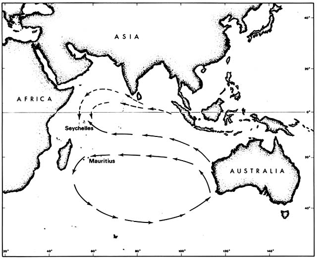
Figure 2. Prevailing Indian Ocean Currents Upstream from Seychelles and Mauritius. Although the currents
are not constant, drifting seeds of tropical beach plants are more likely to reach the Seychelles than Mauritius.
Some such species that arrived prehistorically in the Seychelles have since been artificially introduced to Mauritius.
in the Seychelles, although the first clear records are from the nineteenth century.
The rich native beach flora of the Seychelles, as compared to Mauritius, may result from the pattern of ocean currents. The Seychelles lie in the Equatorial Current downstream from Java, the rest of the East Indies, and many Pacific islands. Mauritius is far enough south to lie within the great counterclockwise circulation around the southern Indian Ocean and is thus downstream from the southern and western coasts of Australia. Such currents are variable, of course, but evidently not enough to erase different effects on dispersal.
Transfers Between Old and New Worlds
(Sauer 1982)
Some of the Indo-Pacific beach species introduced to Mauritius were also introduced through botanical gardens to the West Indies. Casuarina equisetifolia and Terminalia catappa from the East Indies were being grown in Jamaica by 1790, and Morinda citrifolia probably arrived soon after. All three were widely planted in the New World tropics during the nineteenth century, Casuarina for timber and fuel, Terminalia as a shade tree, and Morinda as a medicinal and dye plant. Herbarium specimens show that by mid-nineteenth century, all three had escaped from cultivation and were spreading on their own along seashores. Once in the region, Terminalia and Morinda were quite capable of island hopping by sea dispersal; both are recorded as having arrived in Grand Cayman, for example, as drift seeds. Casuarina and Morinda mainly colonize open seashore habitats, but Terminalia invades dense coastal thickets and overtops native trees.
Not all introduced Indo-Pacific seashore species have been so successful. Cocos nucifera, Barringtonia asiatica , and Scaevola taccada are commonly planted in the Caribbean region, often around beach houses, but are not spreading on their own.
Various Caribbean beach species have been widely planted in the Indo-Pacific region, including Mauritius, and have escaped to a few beaches, for example, spiderlily, Hymenocallis caribaea ; yellow bells, Tecoma stans ; whitewood, Tabebuia pallida ; frangipani, Plumeria spp.; and cocoplum, Chrysobalanus icaco . The cocoplum has become particularly successful on beaches of Viti Livu, Fiji. It had escaped to several beaches by 1962, and by 1984 it was extensively codominant with the native shrubs in beach ridge thickets on Viti Livu.
Anacardium occidentale , the cashew, has naturalized more extensively. Native to coastal dunes of northeastern Brazil, the cashew was introduced
by the Portuguese early in the colonial period to West and East Africa, India, and the East Indies; other people soon joined in planting the trees. The fruits are attractive to many animals, including monkeys, and the seeds are capable of at least local sea dispersal. Herbarium specimens show that by the mid-nineteenth century, the cashew was naturalized on many seashores of East and West Africa, tropical Asia, and the East Indies.
Comment
Like mangrove swamps, tropical sea beaches have a rich and very discrete flora. Few species transgress between these beaches and other kinds of habitats. There are minor exceptions, including the cases noted above when inland weeds temporarily invaded beaches after hurricanes and torrential rains. Conversely, beach species can invade adjacent inland sites when their normal competitors are removed. For example, in the Caribbean and Indian Ocean after World War II, abandoned military installations were commonly overrun by Canavalia maritima and Ipomoea pes-caprae vines.
For the outpost species, normal survival in a habitat within reach of storm waves involves perpetual micromigration, even on a stable coastline. Less extreme situations than the hurricanes discussed above include winter northerly storms and summer calms along the Mexican Gulf coast and monsoonal wind shifts on the East African coast. Beach ridge thicket species live in habitat largely controlled by a salt spray gradient and only marginally affected by storm waves. Where a coastline is progressively eroding or advancing, both outpost and thicket species may survive by local migration without any species extinctions within sites or recruitment of species from other sites.
Sea dispersal of tropical beach species has allowed them to colonize habitats that are spatially extremely discontinuous, not only on islands but on mainland coasts. Both outpost and thicket species are excluded from topographically sheltered shorelines by mangroves and inland species. Some beach species are excluded from bedrock or shingle coasts or from black sand or quartz sand beaches. Moreover, unlike mangroves, beach species need fresh water. They can survive a dry season by drawing on the fresh water lens floating in the sand above the denser salt water, but they are excluded from coasts where there is too little rain to maintain this lens.
Unlike many mangroves, the beach species produce seeds that remain dormant while afloat, with the embryos protected from seawater. As discussed in the Introduction, in two beach ridge thicket species, Tournefortia argentea and Scaevola taccada , breaking of dormancy requires a sequence of flotation in the sea, brief or long, followed by stranding and wetting by rain. Other beach species have seeds with extremely thick, hard integuments that remain impermeable during flotation for at least several months; they also
resist scarification by surf and sand. Presumably they germinate when the integument decays after long burial in moist sand.
As in the mangroves, adaptation for sea dispersal of beach species is probably not the result of selection for long-range dispersal per se, but for persistent buoyancy, since any seeds that sink at sea are eliminated as contributors to the gene pool of their species. The effectiveness of such selection is shown most dramatically by the outpost species, a dozen of which have naturally pantropical ranges. A few thicket species also have long-buoyant seeds and have achieved naturally pantropical ranges. Most thicket species have seeds that float for more moderate time spans or have fruits attractive to birds and bats, or both. It is within this latter group that recent human dispersal has permitted certain species to naturalize on beaches they had not been able to reach before.
Temperate Sea Beaches And Dunes
Mid-Atlantic Barrier Islands, United States
(Dolan et al. 1977, 1980; Leatherman 1979; Martin 1959)
A chain of barrier islands, with salt marshes and lagoons behind them, lies along much of the mid-Atlantic coast of the United States. Beaches are composed mainly of quartz sand, much more easily moved by the wind than the calcareous sand typical of tropical beaches. As a rule, dunes begin not far above the normal high water mark, leaving only a narrow, discontinuous storm beach at the top of the foreshore. This precarious habitat has a small but distinctive native herb flora. Some species are annuals, for example, sea rocket, Cakile edentula ; seaside spurge, Euphorbia polygonifolia ; and a rare beach pigweed, Amaranthus pumilus . Others are perennials, for example, beach pea, Lathyrus japonicus , and beach sandwort, Honkenya peploides . Only the Amaranthus is endemic; most are shared with beaches of the Great Lakes. Lathyrus and Honkenya are circumboreal.
The dunes form primarily under coarse rhizomatous grasses: in the north, beach grass, Ammophila breviligulata , shared with the Great Lakes and the Atlantic coast up to Newfoundland; in the south, sea oats, Uniola paniculata , shared with the Gulf of Mexico coasts as far down as Tabasco. Both are capable of virtually unlimited horizontal and vertical growth. Thriving under sand burial, they build high, steep dunes. These dune grasses grow in irregular clumps and patches, leaving many bare pockets and swales. Toward the dune front, these bare places have scattered individuals of the
same plants that colonize the storm beach. More protected swales and older dunes to the rear have a much richer flora. A few members of this flora are primarily coastal species: salt marsh cordgrass, Spartina patens ; beach plum, Prunus maritima ; bayberry, Myrica pennsylvanica ; beach heather, Hudsonia tomentosa ; and seaside goldenrod, Solidago sempervirens . These have wide coastal ranges outside the mid-Atlantic region and most also occur in scattered inland saline and sandy habitats. The bulk of the species present in the inner dune flora are primarily inland in distribution. Some are pioneers of open habitats, for example, little bluestem, Andropogon scoparius ; red cedar, Juniperus virginiana ; and poison ivy, Rhus radicans . In protected dune hollows, forests develop that have wind-shorn tops but share tree species with inland forests.
Prevailing winds are generally offshore, thus, traumatic events for the beach and dune vegetation are concentrated during storms. Occasional tropical hurricanes, with huge waves superimposed on storm surges, cause washovers and sometimes cut new inlets clear through barrier islands. Each year, 35 to 40 ordinary winter cyclones have onshore winds and waves strong enough to erode beaches. Occasionally one of these causes catastrophic erosion and washovers comparable to hurricane effects.
These barrier islands are believed to be inherently unstable and, in the long run, not under control of the vegetation. Large masses of sediment were moved landward during the great postglacial rise in sea level. About 6,000 years ago, as sea level began to stabilize at nearly its present level, waves, longshore currents, and winds working together formed barrier islands from the surplus sand. As long as the inshore zone contained sufficient sand, the islands built seaward, with the oldest, highest dunes at the rear. This progradation continued until about 2,000 years ago when the islands were much wider than now. Thereafter, net removal of sand offshore began; also blowouts and washovers pushed some sand over the islands into the lagoons. Thus, at present the islands are becoming narrower and migrating landward. As the islands become narrower, washovers are becoming more frequent, causing extensive burial by sand of the salt marsh vegetation along the lagoons. In the southern part of the region, marsh plants, including Spartina patens and Solidago sempervirens , commonly survive in the washover fans by upward regrowth. In the northern part, overwash fans are often colonized by Ammophila breviligulata , initiating a new, inner line of dunes. Remains of former inner dune forests are being exposed on some eroding foreshores.
Air photography is now being used to monitor shoreline changes over a 630-km reach of barrier islands. Transects at 100-m intervals, 6,300 in all, have been plotted spanning 15 years for the whole island chain and 30 years for much of it. Overall retreat averages 1.5 m/year, with more rapid retreat toward the northern ends of most islands and some accretion toward the southern ends. Retreating roughly 1 mile per century, changes are obvious
to residents. Inevitably, attempts to stabilize the islands are being made. A common approach is to develop continuous stands of dune-building grasses by planting, fertilizing, and watering. This commonly produces a higher, steeper foredune. With greater shelter from the foredune, vegetational succession at the rear proceeds toward an inland forest type. However, since the sand budget is not balanced, the steepened foredune is expected eventually to be undercut and washed away by storm waves, with complete washover of the islands following.
Mustang Island, Texas
In 1959, I laid out what were intended to be permanent 1-m-wide belt transects across the dunes of Mustang Island off Corpus Christi Bay. As usual on Texas barrier islands, there was a gently sloping intertidal beach, about 20 m wide. Just above normal high tide mark and at the base of the abruptly rising foredune there were a few widely scattered plants of Cakile geniculata and Amaranthus greggii , annual herbs endemic to Gulf of Mexico beaches on both sides of the tropics. The dunes were dominated by Uniola paniculata (discussed in the preceding section), joined here by the pantropical Ipomoea pes-caprae and the Caribbean Croton punctatus . On the backslope of the foredune were scattered grasses and dicot herbs, such as Spartina patens, Sporobolus virginicus, Oenothera drummondii , and Heterotheca latifolia . About 20 or 30 m behind the foredune, stabilized dunes had dense vegetation in which the outpost species were joined by Physalis viscosa, Rhynchosia americana, Ambrosia psilostachya , and a variety of other species. Nearly the whole assemblage was shared with the tropical Gulf coast. The transects were based on a government triangulation structure and were staked.
In 1961, the eye of Hurricane Carla crossed the coast close to the study site with winds of about 275 km/hr and waves reaching 7 m above ordinary high water mark. In 1962, the triangulation structure and stakes had disappeared and the transects could be only approximately relocated. Instead of being abut 20 m wide, the intertidal bare beach was now 80 to 90 m wide, extending clear through what had been the foredune zone and into the formerly stabilized dunes behind. Above a steep sand bank, freshly cut by the storm waves, the old dune vegetation appeared undamaged. At the top of the new beach and at the base of the cut bank, there were a few isolated seedlings of Sesuvium portulacastrum and Ipomoea pes-caprae and some resprouting rhizomes of Uniola and Spartina . Near the transected area, where washovers of barrier islands had occurred, seedlings of various beach outpost species were colonizing bared areas far back in the wrecked dunes, the seed presumably having ridden in on the storm waves.
Intercontinental Migration of Ammophila
(Cooper 1958; Dicken et al. 1961; Franklin and Dyrness 1973; McLaughlin and Brown 1942; Rosengren 1981; Sweet 1981)
Marram grass, Ammophila arenaria , native to western Europe, is even more vigorous as a dune builder than the eastern North American A. breviligulata (discussed above). Marram grass has been widely planted for dune stabilization. Where it has been introduced, it commonly has naturalized and spread.
On the Atlantic coast of the United States, marram grass is now naturalized locally, but has not generally displaced its native congener. On the Pacific coast, it has widely displaced a native dune grass, the circumboreal Elymus mollis , which is a relatively weak dune builder.
The amount of sand carried down western North American rivers was drastically increased during the nineteenth century by hydraulic mining, grazing, logging, and farming. Beaches near river mouths built out faster than vegetation could follow and surplus sand moved inland in great sheets and moving dunes. Starting in 1869, the active dune field that was to become San Francisco's Golden Gate Park was stabilized by planting marram grass. Soon after, the Coast Guard planted it to stabilize dunes along Humboldt Bay in northern California. Between 1910 and 1934, the Forest Service, other government agencies, and property owners planted marram grass on many dunes along the Oregon coast. Beginning in 1935, a huge dune field on the Clatsop Plains, south of the Columbia River mouth, was planted with marram grass. The eastern North American Ammophila breviligulata has also been planted on Pacific coast dune fields, but to a much lesser extent.
At the present time, Ammophila is thoroughly naturalized on innumerable stretches of the Pacific coast and has become a powerful geomorphic agent by building fairly continuous wall-like foredunes, which were not previously characteristic of this region. Sheltered behind these walls, formerly active sands have become vegetated with a mixture of native and exotic species. Prominent among these is Scotch broom, Cytisus scoparius , native to sands and sea cliffs of western Europe, which was also deliberately introduced in the late nineteenth century for sand stabilization and has now become thoroughly naturalized.
Marram grass has had a similar history in temperate Australia. Two native Australian beach grasses, Spinifex longifolius and S. hirsutus , are moderately effective sand binders, but they do not form steep, stabilized dunes as Ammophila does. Ammophila is currently replacing Spinifex hirsutus at latitudes above 33°S on many Australian beaches. Substituting stabilized linear foredunes for active transverse dune fields allows advance of woody inland
vegetation, especially Acacia spp. at the expense of various beach pioneer species.
Naturalization of Chrysanthemoides , Australia
(Gray 1976)
Chrysanthemoides monilifera is a shrubby composite native to the temperate southeastern coast of Africa, where it grows behind the storm beach on dunes and sea cliffs. The seeds are not buoyant and are probably bird dispersed. The species spreads vegetatively with vigor.
The species has been cultivated in the Sydney Botanical Garden and elsewhere in Australia since the late nineteenth century. Early in the present century, it escaped to beaches in New South Wales and on Lord Howe Island offshore. After 1950, it was much planted by the Soil Conservation Service to stabilize dunes and revegetate sand mining areas. This planting was stopped when it was found that Chrysanthemoides was invading and in places eliminating the complex native dune flora. In 1981, I saw several dense pure stands of this exotic on New South Wales beaches between 28° and 36°S latitudes, but none on any Queensland or Victoria beaches.
A reciprocal invasion of native South African coastal vegetation by introduced Australian Acacia cyclops and A. saligna is out of control (Taylor 1978).
Naturalization of Mesembryanthemum , California
(Blake 1969; Ferren et al. 1981; Moran 1950; Vivrette and Muller 1977)
The genus Mesembryanthemum s.l. (sometimes split into more than 100 genera) has thousands of species native to South Africa. Many of these are widely cultivated by fanciers of succulent plants. For example, M. edule (= Carpobrotus edulis ), native to the Cape Province and Natal, has been cultivated in Europe since the seventeenth century and in Australia and California since the nineteenth century. Although now widely naturalized there on sea beaches, it is generally recognized as an exotic that has escaped from cultivation.
Migration of a species very closely related to Mesembryanthemum edule , namely M. aequilaterum (= Carpobrotus aequilaterus ) is problematic. It is not known from South Africa and is generally considered to be native to either Australia, Chile, or California, or all three. The species was described in 1798 by Haworth from plants cultivated in England that were reported to be
"native to the country around Botany Bay." Either by oceanic drift or by transport on a ship, the species reached Chile before 1810, when it was collected at Valparaiso and named M. chilense . The first California record is from Bodega Bay in 1841. There are various plant species that apparently have naturally disjunct ranges between Chile and California, presumably due to dispersal by migratory birds. However, in this particular case, nineteenth-century human introduction appears likely. Mesembryanthemum aequilaterum is still actively spreading on the California coast. For example, at Point Dume in Los Angeles County, local residents have observed its expansion; in what was planned as a natural coastal reserve, it is spreading as a thick blanket that is overwhelming the native dune vegetation. However this species reached Chile and California, it seems that it originated in Australia along with several very closely related species that are Australian endemics. One of these, M. glaucescens (= Carpobrotus glaucescens ), appears in a water color painted at Sydney by Governor Arthur Philip about a year after the arrival of the first British colonists. The progenitor of these endemic Australian species must have come from South Africa long before, perhaps by oceanic drift.
Several other Mesembryanthemum species that are known to have been imported from South Africa have escaped from cultivation and are naturalized along the coasts of California, Baja California, and the offshore islands, for example, M. crystallinum and M. nodiflorum , which have been spreading since 1890, and M. croceum , which has been spreading since 1940.
Naturalization of Cakile , Australia and Western North America
(Barbour and Rodman 1970; Rodman 1974)
Various species of Cakile , the sea rockets, grow as extreme outpost pioneers on storm beaches. As noted in the Introduction, they have a peculiar mechanism for dividing their seeds between in situ reproduction and sea dispersal. Part of the seed is buried with the dead annual parent and part floats away, remaining viable for at least 10 weeks in seawater, but germinates only after being stranded and rained upon.
Cakile edentula is native to the Atlantic coast of North American from Labrador to Florida and the shores of the Great Lakes. In Australia, it appeared near Melbourne before 1863 and near Sydney by 1870, supposedly brought in sand ballast by an American sealing ship. It soon spread on its own to all the southeastern Australian states, including Tasmania, and to Lord Howe Island (fig. 3). By 1922 it was moving north along the temperate Queensland coast and by 1960 reached Heron Island on the Tropic of Capricorn. In 1981, I did not find it on any tropical Queensland beaches. Moving
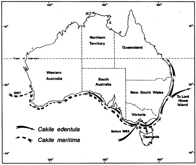
Figure 3. Naturalization of Cakile on Australian Beaches. Temperate beach species have repeatedly found open
niches distant from their native ranges following introduction by human agency. Two species of sea rockets that
arrived in Australia in the late nineteenth century spread by sea dispersal from their entry points along Australian
beaches, often advancing at a rate faster than 50 km/year until reaching their climatic limits. These grow closer to the
sea than native beach plants.
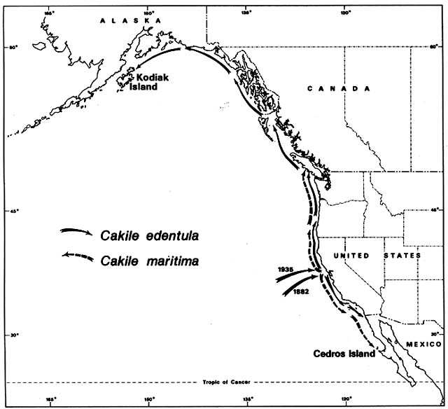
Figure 4. Naturalization of Cakile on Western North American Beaches. The sea rockets that invaded Australian
beaches were also accidentally introduced to the California coast. Cakile edentula from the Atlantic coast of North
America arrived first in San Francisco Bay. It then spread rapidly northward and southward. Before its migrational
history was investigated, some botanists mistook it for a native. Cakile maritima arrived much more recently from
Europe and has always been recognized as introduced.
westward from Melbourne along the south coast, C. edentula met and mixed with another invading sea rocket, C. maritima , which was moving in the opposite direction.
Cakile maritima is native to the Mediterranean and Black seas and to the Atlantic coasts of Europe as far north as southern Scandinavia and Scotland. It arrived at the port of Fremantle, Western Australia, by 1897. By 1963, it was ubiquitous on Western Australia beaches from 31°S southward; I found it on every one of 18 beaches studied in this region. Moving eastward along the south coast, C. maritima had entered South Australia by 1918 and Victoria by 1922. For a while, C. maritima and C. edentula shared the coasts of South Australia and Victoria, but C. martima now has sole possession of these Mediterranean type, dry summer coasts. Cakile edentula remains dominant along the temperate east coasts of New South Wales and Queensland, where summers are wetter.
On the Pacific coast of North America, the same sea rockets have immigrated in a pattern remarkably parallel to that in Australia. Again, Cakile edentula arrived first (fig. 4); the earliest record was on the Berkeley shore of San Francisco Bay in 1882. By 1891 it was common around the Bay, and outside the Golden Gate it had moved 30 km south to Half Moon Bay. By 1906 it had arrived at San Diego, where its southward expansion ended. By 1952 it was on the Channel Islands off the coast of southern California. Meanwhile, moving northward from San Francisco, it arrived in Oregon by 1901, Washington by 1907, British Columbia by 1909, and Kodiak Island off Alaska by 1931. The northward expansion had averaged 65 km/year over a 50-year period.
Local botanists, aware of the rapid spread of Cakile edentula , recognized it as an immigrant. However, the then dominant Harvard taxonomist, M. L. Fernald, temporarily confused the story by suggesting the Pacific coast populations belonged to a native endemic variety, which he named C. edentula var. californica . He postulated a formerly continuous boreal range, which became disjunct during the Pleistocene, a concept closely related to his nunatak hypothesis for other North American disjuncts. This variety is no longer considered distinguishable from the species proper.
The European Cakile maritima arrived in California so recently that no botanists have mistaken it for a native. It was first recorded in 1935 on a popular beach 25 km north of San Francisco. It spread almost as fast as C. edentula , averaging about 50 km/year in both directions. Northward it reached British Columbia by 1951, and southward it reached Cedros Island off the coast of Mexico by 1963. As in Australia, C. maritima almost completely replaced C. edentula in the region of Mediterranean type, dry summer climate. From Oregon northward, in areas with summer rain, C. edentula has remained predominant.
In both Australia and western North America, if only the present, static distributions of the two sea rockets were known, their nearly discrete ranges would appear to be directly controlled by climate. However, the actual history shows that Cakile edentula was quite successful outside its present climatic limits before the arrival of C. maritima . The outpost zone on a storm beach would at first glance seem one of the last places in the world where competitive displacement of one species by another would take place. Only a small part of the area is occupied by plants and for only part of the year. Nevertheless, if we recognize that the beach is not homogeneous, that there may be very limited safe sites for sea rocket establishment, and that the expanse of bare sand may be an uninhabitable wasteland for both species, we can visualize fierce competition in spite of low population density.
Comment
Temperate beach plants, like tropical ones, are relatively indifferent to rainfall gradients provided there is enough rain to maintain a freshwater supply under the sand. The greater seasonality of temperate coasts probably affects beach plants mainly via changing wave energy. Lacking fringing coral reefs, temperate beaches commonly have an annual cycle of strong erosion and accretion. Also, temperate zone beaches are generally composed mainly of quartz sand, which is more restricted in distribution in the tropics. Quartz sand is transported by longshore currents and is easily moved by the wind when dry, unlike calcareous sand, which is of local origin and normally immobile under the wind. Thus, many temperate barrier beach and dune systems are relatively extensive and dynamic. In spite of this, their floras are relatively poor in primarily coastal species except in South Africa and Australia, regions that are also phenomenally rich in primarily inland floras on ancient sand plains.
The primarily coastal, drift-dispersed outpost species have less broad and disjunct ranges in temperate than in tropical regions. A few that now have disjunct circumboreal ranges may be relicts from ancient distributions along former seaways. Similarly, the eastern North American beach species that now have disjunct ranges on the Great Lakes and Atlantic coast may have colonized the interior in early postglacial time when a marine embayment provided a continuous route, subsequently broken by isostatic uplift (Rodman 1974). Clearly, this species group is dependent not on salt water or salt spray but on waves, wind, and moving sand to create its habitat.
Like tropical beach pioneers, temperate outpost species need drift dispersal to occupy a dynamic and discontinuous habitat, but the temperate species have seeds that are buoyant for a shorter time. Perhaps this is because seeds
floating longer distances in temperate latitudes would have less chance of survival because the prevailing currents run north and south along the coasts rather than east and west through island stepping stones. The examples noted above of naturalization and spread following artificial introduction to distant regions demonstrate that the species had been unable to reach parts of their potential areas by natural long-range dispersal. They also demonstrate these species' capacity for rapid stepwise migration along a coastline and to offshore islands. Many similar cases, not discussed above, are known, for example, naturalization of Artemisia stelleriana and Carex kobomugi , native to northeastern Asia, on eastern North American beaches, and naturalization of Rumex frutescens , native to temperate South America, on British and Danish dunes. Some of these naturalized exotics have found an unoccupied niche closer to the sea than the native beach vegetation; others have invaded and displaced native dune species.
Salt Marshes
Limited Successions in Coastal Marshes, Britain
(Chapman 1959, 1976; Ranwell 1972; Tansley 1947)
Salt marshes have long been a favorite object of ecological studies in Britain; their history and dynamics do not support a model of succession leading to climax vegetation. Tansley (1947) concluded long ago that there is no good evidence that salt marshes can develop into nonmaritime vegetation by the mere accumulation of silt or humus.
A time-lapse study of a complex of Norfolk marshes over 25 years showed that in local areas where accretion of sediment happened to outrun regional subsidence, there was a predictable sequence of plant species. Commonly the first colonist of accreting mudflats, just above low tide mark, was a creeping monocot, Zostera noltii , followed in sequence by Salicornia europea, Aster tripolium, and Spartina townsendii s.l. The last is a rank, rhizomatous grass that is an exceptionally effective mud binder, at least temporarily; it is of hybrid origin and has only existed since about 1870.
There are many ways in which such autogenic salt marsh succession can be halted or reversed. Sedimentation may be offset by compaction so that there is little rise in marsh level. Accretion may shift rapidly to erosion because of a change in sediment supply or with strong onshore winds. Established marsh vegetation may be killed by deposition of flotsam and by
formation of stagnant pools and hypersaline flats. Also, marshes undergo cyclical deposition and dissection along tidal creeks. Steep banks inevitably develop along the creeks by a combination of deposition of natural levees under overbank flow on flood tides and scouring of channels on ebb tides. Eventually undercutting and collapse of banks starts the cycle over.
Limited Successions in Coastal Marshes, California
(Pestrong 1965; Warme 1971)
A similar cycle of bank buildup and collapse occurs along tidal creeks on San Francisco Bay mudflats. There is a correlated cycle of two dominant perennials, a pickleweed, Salicornia virginica , which grows on the natural levees, and a tall cordgrass, Spartina foliosa , which grows in the tidal creek channels, where it may endure 20 hr of submergence daily. As sediment is deposited on the natural levees at flood tides and scoured from the bank bases at ebb tides, banks become oversteepened and collapse. Salicornia does not survive submergence on the slump blocks but is replaced by Spartina , which traps sediment until bank buildup allows recolonization by Salicornia .
Salt marsh dynamics are more complex on Mugu Lagoon in southern California. Topographic maps spanning more than 100 years show that the eastern end of the lagoon, about 1.5 km long and as much as 0.5 km wide, has been mostly converted from open water to intertidal marsh. Recent measurements of staked areas show marsh advance at rates as high as 1 m/year. The marsh plants show fairly regular zonation, part of which can be fitted to an autogenic succession model. The subtidal lagoon has beds of eelgrass, Zostera marina , and ditchgrass, Ruppia maritima , which help trap sediment and shells and upgrade the substrate to the low tide mark. There is a barren zone above low tide mark where aggradation must be independent of plants. Spartina foliosa , which occurs at this level in other California marshes, is present here in only small, isolated patches. Above this bare zone, the lower fringe of marsh vegetation is dominated by annual Salicornia europea and perennial Salicornia virginica . Above 1.5 m above low tide mark, these chenopods are joined by 10 or so other species, mostly perennials, including other chenopods. These continue to the upper reach of highest tides, where they are joined by Arthrocnemum subterminale as a dominant. The vegetation of the middle and upper marsh is generally very thick and evidently capable of aiding sedimentation. However, rather than proceeding toward climax upland vegetation, older parts of the marsh become hypersaline areas, with salinities over twice that of seawater during the rainless summers, where expanding bare salt pans develop.
The Mugu marsh is strongly affected by various geomorphic processes that are not under control of autogenic vegetational succession. The marsh lies at the mouth of Calleguas Creek, normally a minor intermittent stream. During exceptionally heavy rains, the creek pours huge quantities of sand into the lagoon. The lagoon and marsh lie behind a barrier beach, the last of a series that formed sequentially offshore on an uplifted fault block since postglacial sea level stabilized. Sand being brought down the coast by longshore currents enters the lagoon through the tidal inlet. Also, during winter storms, ocean sand is poured over the barrier beach by washovers. A deep submarine canyon, with its headwall in unconsolidated sediments, has cut back almost to the mouth of the tidal inlet. It is on the verge of capturing the longshore sand supply and reversing the whole process of marsh development.
Primary Succession on a Mediterranean Lagoon, France
(Braun-Blanquet et al. 1958)
Soon after hearing about Clementsian succession theory, Braun-Blanquet initiated a time-lapse study to test the postulated relationship between salt marsh zonation and primary succession. The site chosen was on an aggrading tidal lagoon shore near Montpellier; initially it included a cove 30 m wide behind a narrow sand spit. The site was mapped nine times over a 43-year span; the study ended when the site was artificially disturbed. Seaweeds and marine angiosperms, for example, Ruppia maritima and Zostera marina , were present below low tide mark but were not mapped.
When the study began in 1915, the sand spit was mainly bare except for a narrow fringe near the high tide mark of annual chenopods, such as Salicornia europea, Suaeda maritima, and Salsola soda, and a few common reeds, such as Phragmites australis , that had taken root from stranded rhizomes. Along the shore of the lagoon was a belt a few meters wide dominated by perennial chenopods, such as Arthrocnemum spp. and Halimione portulacoides ; between them and higher ground was another narrow belt dominated by a rush, Juncus maritimus . Within its original area of about 100 m2 , the site also had 19 other less abundant species, all halophytes, such as sea lavender, Limonium vulgare , and sea aster, Aster tripolium .
By the end of the study in 1958, wave-deposited sand and shells had caused the shoreline at low tide mark to advance about 50 m, adding over 1,000 m2 to the study area. Fresh shell ridges had cut off two depressions within the former cove; the shallower one was covered with perennial Arthrocnemum spp.; the deeper one retained a pool of open water inside an Arthrocnemum ring. The thin fringe of annual chenopods and reeds had moved forward with the advancing shoreline. Behind it, better-drained sand
and shell areas were dominated by a steadily expanding Halimione colony. At the rear of the study area, the initial Juncus zone had remained relatively stationary, but had moved slightly seaward into the Arthrocnemum -dominated area and was in turn being invaded at the rear by Spartina versicolor , a tall grass growing in both saltwater and freshwater marshes. At the same time, the better drained Halimione -dominated areas were beginning to be invaded by tall Juncus acutus and Limonium vulgare .
Interrupting the steady seaward advances were setbacks, when strong mistral winds and waves opened up patches of established vegetation for recolonization by the pioneer fringe species. Also during the rainy season, ephemeral populations of weedy annuals appeared on the tops of shell ridges, including Polygonum aviculare, Stellaria media, Galium aparine, Sonchus oleraceus, and Senecio vulgaris .
Measurements of soil variables and plant osmotic pressures suggested that species distributions were largely controlled by soil moisture, salinity, and aeration. Halimione occupied sites with the greatest contrasts between rainy and dry season soil conditions and had the greatest range of osmotic pressure, from less than 25 to more than 60 atm.
As for testing the model of primary succession, the results are equivocal. The results generally agree with the model in showing a tendency for the vegetation zones to advance as sediment was deposited on the shore. The results do not prove the crucial assumption of a Clementsian autogenic succession model, namely, that changes in the ecosystem are directional and under control of the vegetation. In this case, the changes may have been allogenic, that is, due to surplus shell supply, leaching of sediments by rain, or other processes not under vegetational control. The study site was chosen on an aggrading shore. If vegetation changes passively follow shoreline changes, the zones may be static or retreating on other shorelines.
Natural Colonization of Artificial Inland Salt Marshes,
Europe and North America
(Ogle 1981; Simon 1958; Zumph and Rebmann 1932)
As a waste product of salt mining operations, saline ponds were created 40 km south of Berlin in 1907. Within 3 years the ponds were colonized by halophytes, including Triglochin maritima, Glaux maritima, and Plantago maritima . The botanists who studied the colonization believed the seed had been brought from seacoast marshes by waterfowl; it is also possible the seed had been transported from other saline inland places, although none were known closer than 30 km.
Commercial exploitation of a salt dome at Müllhausen, Alsace, began in
1904. Salt ponds created by slurry dumping were visited by migratory waterfowl. By 1954, the ponds had been colonized by halophytes, including Chenopodium botryodes ; the nearest seed source known for some of the species was 500 km away.
In western Virginia, 400 km from tidewater, pumping of brine wells since the late nineteenth century has created a habitat for various salt marsh species, for example, Salicornia europea and Eleocharis parvula . A new species, Scirpus robustus , was found in 1977; its population expanded rapidly in the next few years. All the species are believed to be dispersed by birds.
Naturalized Exotics, California
(Robbins 1940)
In the late nineteenth century, E. W. Hilgard, head of the California College of Agriculture, imported seed of various species as possible forage plants for alkali lands. From Australia, Baron Ferdinand von Mueller sent seed of several species of Atriplex , including A. semibaccata , which has grown successfully at the Tulare experiment station and from there has been widely distributed in California. The first escape to a tidal marsh was reported by botanist Alice Eastwood in 1901. She found it flourishing in a marsh north of San Francisco. By 1935, it was widespread along the mainland coast and on offshore islands. Today it is extremely common, even dominant, in the upper parts of coastal marshes and other saline habitats.
Several other salt marsh species arrived in California by unrecorded means, an obvious possibility being in sand used for ship ballast. Brass buttons, Cotula coronopifolia , native to South Africa, was found in San Francisco Bay in the Early 1850s and has since become common along the whole mainland coast and on offshore islands. Two grasses native to western Europe and the Mediterranean, Monerma cylindrica and Parapholis incurva , were first recorded near San Diego about 1900 and have since spread far northward along the California coast; Parapholis has also reached offshore islands. A European chenopod, Bassia hyssopifolia , may have arrived in California indirectly via Argentina as a contaminant in alfalfa seed. It was naturalizing in inland alkali and saline habitats by 1920; at present it is invading coastal marshes near Santa Barbara.
Comment
A few exceptional plant species, including Phragmites australis and Cotula coronopifolia are shared between saline, brackish, and freshwater marshes, but
on the whole, salt marshes have a very discrete flora. Most salt marsh species are confined either to coastal marshes subject to tidal flooding or to interior marshes that may be only seasonally flooded, but a few are capable of growing in both. For species capable of coping with the extreme osmotic pressures of these habitats, the reward is escape from competition from ordinary nonhalophytes.
In many salt marshes, plant species can survive indefinitely with only micromigrations and no capacity for long-range dispersal. There are cases of salt marsh species that have evolved as localized endemics, for example, several Atriplex species in the San Joaquin Valley of California. However, many salt marsh species have very wide and disjunct distributions. Some species are known to be capable of long-range dispersal by ocean currents, such as Salicornia spp., which have seeds capable of floating for months (Ranwell 1972). Such dispersal may explain some grand disjunctions, such as the transatlantic ranges of Salicornia europea and S. virginica . It cannot explain the presence of these two species on both Atlantic and Pacific coasts of North America. For many such disjunctions, particularly involving inland populations, bird dispersal seems to be the best explanation. Disjunct salt spring floras in the interior of Europe have sometimes been attributed to fragmentation of populations that were continuous during Pleistocene arid periods, but Aellen (1958) argued that known cases of recent bird dispersal obviate the need for such explanation.
The cases noted above of naturalization following long-range human dispersal involved disjunctions that birds were unlikely to span.
Freshwater Aquatic Habitats
Vernal Pools, California
(Griggs 1981; Jain 1976; Keeley and Keeley 1979; Thorne and Lathrop 1969)
Seasonal lakes and pools in California grasslands are tiny relicts of native herbaceous vegetation in a sea of European annuals. They harbor over 200 species of flowering plants in about 50 genera, many of which are found in no other habitat. Most are in the Central Valley on Pleistocene alluvium underlain by an impervious hardpan or claypan. Some are on ancient lateritic soils on mesas formed by basalt flows.
Under the present Mediterranean climate, habitat conditions vary drastically with the seasons and from year to year. Most of the species are annuals.
These may bank large quantities of seed in the soil in wet years; the seed may remain dormant for years or decades. For example, in one pool a rare grass, Orcuttia pilosa , grew abundantly one year, disappeared completely for 4 years, and reappeared in abundance the fifth year, when the soil still contained 50 dormant seeds for every one that germinated. Orcuttia seed germinates only when infested with certain fungi, which are abundant only when the pond is flooded. Orcuttia seedlings start life as submerged aquatics, then develop floating leaves and become tall emergents when the water level drops; when the pool dries, flowering begins within days.
Annual censuses of the flora of a vernal marsh on the Mesa de Colorado in southern California showed species appearing that had not been seen in previous years, for example, Potamogeton pusillus and Elatine californica in 1968 and Orcuttia californica and Myosurus minimus in 1969. Whether these were new immigrants or from dormant seed is not known.
Some vernal pool species are endemic to California or at least to the far western United States, including several congeners in Orcuttia, Limnanthes, Elatine , and Downingia . Some are disjunct between temperate North and South America, for example, Deschampsia danthonioides, Elatine chilensis , and Lilaea scilloides . Some are shared between North America and Eurasia, for example, Crassula aquatica, Eleocharis palustris, Callitriche palustris, Potamogeton pusillus , and Myosurus minimus . A few range from the Old to the New World and from the northern to the southern hemisphere, such as Juncus bufonis and Lemna minor .
The likelihood of long-range bird dispersal of these species is discussed at the end of this chapter. Local bird dispersal of recently introduced exotics appears likely in a few cases. Naturalization of the South African Cotula coronopifolia in California salt marshes was noted in the preceding chapter. This species has also spread inland around vernal pools, including those on the Mesa de Colorado. Another annual, Lythrum tribracteatum , native to southern Europe and the Near East appeared in California in 1930 in a vernal pool near Sacramento. By 1948 it had spread 200 miles southeast in the Central Valley to a lake that dries each year; other widely scattered populations have since appeared in seasonally flooded central California sites. In 1978, Aponogeton distachyus , the Cape pondweed from South Africa, was discovered in vernal pools on Kearny Mesa in San Diego. The species is widely planted in ponds as an ornamental; it has also escaped to natural freshwater habitats in northwestern Europe, western South America, and southern Australia.
Many California vernal pools have quite recently been destroyed by conversion to rice paddies or drainage for other crops. Preserving a few relicts of this increasingly disjunct habitat type is currently an issue in California.
Intercontinental Migrations of Elodea and Hydrilla
(Mitchell 1977; Sculthorpe 1967; Yeo and McHenry 1977)
Two closely related waterweeds have invaded streams in various continents following long-range human introduction. Both are dioecious perennial herbs, rooting in sediment and with the submerged stems bearing whorled foliage like a bottlebrush. Flowers of the pistillate plants open at the water surface to receive floating pollen. Both species are easily propagated vegetatively and have become favorite freshwater aquarium plants.
Elodea canadensis , native to lakes and slow streams of North America, arrived in the British Isles in the 1840s, supposedly imported accidentally with American water lily rhizomes. Although only female plants were present initially, the species spread rapidly by human and perhaps bird dispersal. It was widely naturalized in the British Isles and on the continent by 1879, when a male clone arrived and seed production began. For some years, Elodea proliferated excessively, impeding water flow and boat traffic; control efforts were futile because of rapid regeneration from fragments of the plants. After a few years, populations generally declined spontaneously, possibly due to buildup of predators. Since 1900, Elodea has subsided to become merely another member of Europe's freshwater flora.
In Australia, Elodea escaped by 1960; its spread is unclear because for a while it was confused with the native Hydrilla . It has become a common weed of rivers and ditches in the New South Wales—Victoria border region.
Hydrilla verticillata is regarded as native in temperate and tropical eastern and northern Australia, the East Indies, southeast Asia, and various western Pacific and Indian Ocean islands. It can reach the surface and establish a dense canopy in water as deep as 15 m. Introduced to North America in the aquarium trade, it was first noticed growing wild in Florida in 1958; by 1967 it occupied tens of thousands of acres of waterways in Florida and neighboring states. Only male plants are present there, but the species is dispersed vegetatively, probably by waterfowl and trailered boats. Drag lines haul it out by the ton to keep waterways open, but it promptly grows back.
In California, Hydrilla was found to have become naturalized in the Sacramento Valley in 1976; it has since spread widely in the state. It has become a serious problem in canals and irrigation ditches in southern California. In 1985, the state Department of Fish and Game authorized the Hydrilla Control Research Project to stock all canals of the Imperial and Coachella valleys with 78,000 Amur River grass carp. A mutant triploid strain of the fish is being used, which is expected to live about 5 years and die without reproducing.
Hydrilla has escaped in many other warm regions in both natural and artificial lakes and streams. Gatun Lake, Panama, has a flourishing infestation.
A similar case of naturalization following long-range dispersal through aquaria involves Lemna minuscula , a tiny floating aquatic native to the New World; it has apparently been spread by bird dispersal through European lakes and streams (Landolt 1979).
Intercontinental Migrations of Eichhornia and Alternanthera
(Bock 1968, Hockley 1974; Maddox et al. 1971; Mitchell 1977; Russell 1942; Varshney and Rzoska 1976; Vietmeyer 1975)
Water hyacinth, Eichhornia crassipes , and alligator weed, Alternanthera philoxeroides , are native to the great river systems of eastern South America from the Orinoco to the Paraná. Both root in shallow water along stream banks and may extend out over deep, quiet water as floating mats. Both are capable of rapid vegetative reproduction. Water hyacinth has nitrogen-fixing bacteria within the leaf and grows well in clean water. Alligator weed grows best in nutrient-enriched water; it can tolerate brackish water better than water hyacinth. In their native habitats, neither species is especially abundant or conspicuous. When introduced abroad, both have commonly produced prodigious biomass, presumably because of release from natural predators.
At home or abroad, both species survive devastating floods. When the bulk of the floating mats are carried off, survivors in backwaters remain. Water hyacinth also stores dormant seed in the mud, which remains viable for at least 15 years. Outside its native area, alligator weed seems to reproduce only vegetatively; although it has bisexual flowers, a clone may be incapable of self-fertilization.
The long-range migrations of water hyacinth are easily explained by deliberate human transport; it produces beautiful flowers and shiny foliage. Alligator weed is an unattractive plant with no known record of deliberate planting. In spite of their differences, the two have had rather similar macro-migrations.
Water hyacinth was introduced from the Orinoco region to New Orleans, Louisiana, in 1884 and spread rapidly as a planted ornamental in pools and ponds all over the southeastern United States. Alligator weed arrived by unknown means in Florida by 1894 and in Louisiana by 1897. These two exotics have profoundly changed the geomorphic processes of the Mississippi Delta and other southeastern waterways. They are more indifferent to water depths than the native aquatics and produce much greater biomass. Bottom sediments under masses of these species are much higher in organic content
and nutrients and lower in oxygen; the whole economy of the water bodies is affected. Moreover, the result is not permanent filling of bayous and marshes with organic sediment that would initiate autogenic succession; the accumulation of weeds and sediment is eventually ripped out by floods.
Expensive efforts to control these species by mechanical or chemical attack have had only brief effect. Alligator weed is exceptionally tolerant of herbicides; herbicides kill water hyacinth plants but not the buried seed. Since 1960, several insect predators found on these weeds in South America have been released in the southeastern United States and are evidently having some effect.
Relatively minor colonies of both species have become established in California. Starting in 1904, water hyacinth spread gradually along the Sacramento and San Joaquin rivers and their tributaries. It has also established a few colonies in southern California, but there are no extensive suitable habitats there. Since 1965, alligator weed has colonized some artificial reservoirs and effluent ponds in southern California. Release of insect predators has been tried; ironically, the weed populations are so small and localized that the insect predators cannot maintain viable populations.
In Australia, water hyacinth has been widely planted since 1894. In New South Wales, it escaped to become a temporary nuisance along some rivers but has been nearly eliminated since 1935. In Queensland near the Tropic of Capricorn, construction of a barrage in 1970 on the Fitzroy River estuary greatly encouraged water hyacinth by stopping incursions of tidal seawater and flushing by freshwater floods. By 1973 the lower Fitzroy was covered with water hyacinth for over 50 km above the barrage. A costly spray and cutting program was followed in 1975 by release of a South American weevil obtained from a biological control program used in the southeastern United States. Alligator weed arrived in New South Wales by 1945, being first noticed on heaps of ship's ballast dumped near Newcastle. It has subsequently colonized about 10 localities, mainly in irrigation canals and rivers with sewage effluent.
In Java, water hyacinth was grown in the Buitenzorg Botanical Garden in 1894 and soon escaped to streams flowing through the garden. In Bengal, it was introduced from Australia in 1897. By shortly after 1900 it was being widely planted in Ceylon, Malaya, Siam, Indo-China, and China; its spread was partly in botanical gardens, largely in private hands. Its flowers were used as temple offerings, and it was planted in farm ponds to produce pig fodder, feed fish, and provide green manure. It has escaped to the Ganges, Mekong, and other rivers where it interferes with navigation and aggravates floods during cyclone passages. It chokes many of the canals in Bangkok. The alligator weed is rather uncommon in the East Indian—Southeast Asian region, although it arrived in Java by 1895 and has reached the mainland.
In Africa, the earliest available record of water hyacinth is from El Gizeh near Cairo, where it was growing in ditches and ponds in 1930. Evidently the lower Nile region offered little suitable habitat because the great invasion came by another route. In 1954, water hyacinth escaped from ornamental plantings in the Belgian Congo; it rapidly exploded into a major pest, interfering with navigation on the Congo River. In 1957, it was discovered in a remote part of the Sudan 300 km upriver from Khartoum on the White Nile. The watershed between the Congo and White Nile is narrow; perhaps cranes or other water birds carried the seeds across. In 1958, a survey found that the species was established along hundreds of kilometers of the White Nile; by 1962, it extended from Juba to the Gebel Aulia dam near Khartoum, a huge expanse bracketing the Sudd region. The Sudd is an enormous freshwater marsh, dominated by emergent aquatics, such as Cyperus papyrus and various species of Typha and Phragmites . Maintaining navigation channels through this morass had required heroic efforts; invasion by water hyacinth frustrated these efforts and, by raising the water level of the marsh and increasing evaporation, reduced the whole flow of the Nile. Work was begun on a 350-km-long canal to bypass the Sudd and increase the Nile flow, but has been halted by a long civil war.
Comment
Freshwater aquatic habitats harbor a rich and discrete flora. Whole genera and even families have evolved in these habitats. Monocots are especially well represented, but there are a variety of dicots and some gymnosperms. Growth forms range from the tiniest of herbs to great swamp trees. As noted in the preceding chapter, only a very few species are shared between freshwater, brackish, and salt marshes.
Geographic patterns of species are heterogeneous, but in general, microdistributions are sharply limited by water depth and other local variables while gross ranges are diffuse and disjunct. In the long run, survival of disjunct populations in dynamic habitats requires constant colonization. Local populations are subject to extinction by both catastrophic habitat change and by autogenic succession in low-energy habitats. In the classic theory of primary succession, Kerner von Marilaun (1863) postulated how a lake becomes a marsh and a marsh becomes a meadow.
Disjunctions in ranges of freshwater aquatics are so great that they have sometimes raised doubts about being caused by natural dispersal. Scirpus californicus , for example, has a highly disjunct range from California to Patagonia, Easter Island, and Hawaii. Heyerdahl (1971) suggested that this reed had been planted in the crater lake on Easter Island by prehistoric South American Indian voyagers who arrived on balsa rafts made from the reed. Howevever, growing in the same Easter Island lake is a species of no known
use, Palygonum acuminatum , which also has a widely disjunct range in the Americas. Heiser (1978a ) argued that bird dispersal of both species was more likely. Study of fossil deposits in Easter Island lake may determine when Scirpus arrived on the island.
Wind dispersal may be responsible for moderately wide disjunctions in some species, such as Senecio spp., and for extremely wide ones in others, such as the cosmopolitan cattails, Typha spp., and the common reed, Phragmites australis .
For most freshwater aquatics, migratory birds appear to be the most important agents of long-range dispersal. Ridley (1930) summarized a wealth of evidence that ducks and other water and shorebirds disperse aquatic plants. Some of the evidence is circumstantial, for example, colonization of isolated ponds and marshes that are visited by waterfowl and lack of colonization of those that are not visited. Much of the evidence, however, is quite direct, including many cases where shot waterfowl had viable seeds and vegetative parts in mud on their feet, adhering to their plumage, or carried internally. More recently, deVlaming and Proctor (1968) fed captive waterfowl seeds of 23 species of aquatic or semiaquatic plants. They found that viable seeds of most species were passed by killdeer or ducks or both after 20 hr or more, long enough for the birds to fly over 1500 km. Viable seeds of Potamogeton pectinatus were retained for 75 hr by both killdeer and mallards, and viable seeds of Eleocharis quadrangulata were retained 120 hr by killdeer.
Some wide disjunctions of aquatic plants fit neatly within major flyways of migratory waterfowl. The southern water hemp, Amaranthus australis , has its main populations in the Everglades and other marshes of the southeastern United States. Its seeds, ripening in the fall, are a major food of migratory birds taking off southward over the Gulf of Mexico and the Caribbean. Distribution of this species south of the United States is extremely disjunct, always in freshwater lakes and marshes: five localities in five different states in Mexico, seven localities in four West Indian islands, one lake in Venezuela, several rivers in the Guianas, and one locality in southern Brazil, which is 4,000 km from the closest Guiana locality but on the same flyway (Sauer 1972). Kloot (1984) noted that nearly all the plants shared between the pre-European flora of temperate South Australia and other continents, mainly Eurasia, are aquatic or marsh species that presumably were introduced from the northern hemisphere by migratory waterfowl.
In North America, slough grass, Beckmannia syzigachne , has evidently been dispersed northward by waterfowl. It has a disjunct but fairly coherent range in marshes of the north central and western United States and in the Canadian prairies, where its seed heads are fed upon heavily by waterfowl moving up the Central Flyway. Farther north its distribution is sporadic. In an intensive study of the arctic Mackenzie River Delta, Gill (1974) found Beckmannia only on lakes frequented by waterfowl and, on those lakes, only in places with especially heavy concentrations of waterfowl.
East—west disjunctions of aquatics between North America and Eurasia are less obviously related to flyways, but there are many records of birds breeding in the Nearctic but wintering in Eurasia and birds breeding in the Palearctic but wintering in the Americas. An example of the latter is the Eurasian widgeon, which breeds in the Palearctic from Iceland to Siberia but has been recorded as a casual visitor over much of North America (Edgell 1984).
The same species of Beckmannia discussed above is found in eastern Asia, the exchange presumably via Alaskan waterfowl breeding grounds. Heslop-Harrison (1953) suggested a similar relay of a number of aquatic plant species shared between eastern North America and Britain; waterfowl from both regions converge on the same summer breeding grounds in Greenland.
The cases of recent naturalization following human dispersal show that, however great the radius of natural aquatic plant dispersal, it was not global.
Riparian Habitats
Mackenzie Delta, Canada
(Gill 1973a,b )
In its great alluvial delta, the complex streams of the Mackenzie River constantly erode banks and destroy old vegetation on the outside of their shifting bends. At the same time, they create new ground for plant colonization on point bars deposited on the inside of their shifting bends. The details of erosion and deposition are complicated by freezing and thawing of the river and of the ground above permafrost and by flooding and ebbing of the river. However, accreting point bars have a fairly consistent sequence of colonization. The first pioneers are typically a nonseed plant, Equisetum , and Salix alaxensis , both capable of surviving regular flooding and rapid sediment deposit. After the site builds up above normal flood level, about 3 to 4 years later, these are joined by seedlings of Populus balsamifera , which for a while is the sole dominant tree. Under the canopy of this poplar, Alnus crispa and several Salix spp. form a shrub layer. The herb layer includes Hedysarum alpinum and several Arctostaphylos and Artemisia spp. The Alnus and Hedysarum have symbiotic nitrogen-fixing bacteria. Eventually, on the uppermost natural levee surface, which is only rarely flooded, Picea glauca invades and becomes the sole dominant as Populus dies out. The other pioneers remain in the understory of the spruce forest and are joined by many shade-tolerant herbs.
An almost identical succession is reported along accreting banks of Alaska floodplains (Van Cleve and Viereck 1981).
Meramec River, Missouri
(Dietz 1952; Sauer 1952)
The Missouri Botanical Garden Arboretum at Gray Summit is largely covered with an Ozark oak—hickory forest, but the Meramec River floodplain has a different kind of vegetation. Every spring the Meramec rises over its banks and changes the topography of its floodplain by erosion and deposition. Old maps and air photographs from eight different time levels over a 100-year span showed that the floodplain vegetation was generally less than 30 years old before being recycled. Pioneer colonization was dominated by Salix interior and other willows. Willow seed floating down the river on the spring flood is viable for only a few days and becomes established only if stranded on fresh alluvium while the flood is ebbing. In the area studied, willow seedlings had formed new rows in only 4 of the preceding 10 years. After 1 year, willows are too deeply rooted to be easily dislodged by the next flood. On accreting sandbars, older willow thickets are invaded by Populus deltoides, Ulmus fulva, U. americana , and Acer saccharinum , which soon become dominant. Other common riparian trees are Platanus occidentalis and Celtis occidentalis . All these trees have seeds dispersed by wind and water.
In addition to the riparian trees, other growth forms colonize sites opened by the river. Sunny sand and gravel bars have clones of switchgrass, Panicum virgatum , a coarse perennial with creeping rhizomes that are very resistant to erosion during floods. Other fresh alluvium unoccupied by trees has patches of rank annual herbs, such as giant ragweed, Ambrosia trifida , and rough pigweed, Amaranthus retroflexus ; both germinate from buried dormant seed when the substrate is disturbed. In a single growing season, one individual of either species may produce tens of thousands of seeds, some of which survive burial in the soil for decades until the soil is again disturbed.
A different colonizing pattern is followed by pokeweed, Phytolacca americana . Like many pioneers, it only germinates in disturbed soil. However, it grows well in both sun and shade and, once established, is not easily eliminated by competitors. The perennial root sends up new shoots every year for 30 to 40 years. The berries attract birds, which disperse the hard seeds widely; the seeds may remain dormant in the soil for decades until disturbed. Pokeweed is not restricted to stream banks, but they probably were its evolutionary cradle.
I mapped the distribution of individual pokeweed in a 500 by 1,500 m study site on the arboretum's Meramec floodplain and adjacent bluffs in 1947
and 1950; the same area was remapped by Alan Covich in 1962 (unpublished data). In 1947 the floodplain part of this site had 175 pokeweed plants, some in areas that had been recently logged, but many others in places with no trace of human activity. In the next 15 years, most of the original plants were carried away by flood erosion or crowded out by competition, so that only about a dozen of the original plants survived in 1962. During the same period, nearly 100 new seedlings became established, mainly in freshly disturbed sites. Such perpetual micromigration is probably the normal way of life for riparian species.
San Pedro River, Arizona
(Zimmerman 1969)
Arid southwestern North America has riparian vegetation remarkably similar to the humid east, considering their quite different regional vegetation. Some eastern species, including pokeweed, drop out west of the 100th meridian, but others, including Panicum virgatum , do not. As a rule, the eastern species are replaced by closely related congeners. In the Sonoran Desert of Arizona, the riparian annuals include Ambrosia aptera and Amaranthus palmeri ; riparian trees include Populus fremontii, Platanus wrightii , and Salix spp. Unlike the adjacent upland desert species, which have seedlings established mainly during summer rains, the Arizona desert riparian trees behave like their eastern congeners. Their seedlings are established on substrates wetted by spring snow melt, and they colonize water courses with sustained flow, not summer flash floods. The same is true of some desert riparian shrubs, such as the seep willow, Baccharis glutinosa .
A separate group of riparian species in the desert region is negatively associated with regularly flowing streams and concentrated along washes with ephemeral flows and no groundwater supply. An example is Chilopsis linearis , a tree with seeds that germinate when buried in warm, wet sand after a summer flash flood.
Tamarix and Other Riparian Invaders,
Southwestern North America
(Everitt 1980; Harris 1966; Robinson 1965; Turner 1974)
The tamarisks or salt cedars include various species of shrubs and trees native to riverbanks and wet saline places of the Mediterranean region and
arid parts of Eurasia. Beginning early in the nineteenth century, various Tamarix species were imported by United States nurseries and widely planted for their graceful feathery foliage and pink flowers. The different species are seldom separately identified by American laymen or botanists, so the tamarisk invasion has to be dealt with on the genus level. In this chapter, only the invasion of natural riparian habitats will be considered; the effect of dam building and altered river regimes will be discussed in Chapter 4.
Herbarium specimens record sporadic naturalization along rivers in the Southwest after 1875, for example, on a sandbar in the Gila River, Arizona, in 1898, but occurrences were local until after 1920. As late as 1926 the U.S. Department of Agriculture was experimenting with planting tamarisk along the banks of the Rio Grande for erosion control. Before 1930, the main tamarisk invasion was under way, and during the 1930s came general awareness from Texas to California of its arrival as an aggressive invader.
The greatest tamarisk infestations in natural habitats in the Southwest are along major rivers that flood from snowmelt in late spring and early summer. Like native riparian trees and shrubs, tamarisk produces seeds that are only briefly viable. Flowering and fruiting, however, extend from late spring through summer, so viable tamarisk seed is blowing in the wind and floating in streams in normal flood season. Tamarisk seeds can germinate while floating. Their best chance of establishment is when they are stranded on fine, fresh alluvium that remains moist enough for rooting.
The native Baccharis glutinosa , tamarisk's most direct competitor, has an advantage in producing seed all year, and if spring melt is early, its seedlings get a headstart. On the Gila and San Pedro rivers, Arizona, however, tamarisk eventually invaded established Baccharis thickets and took over. Tamarisk thickets also prevent establishment of new seedlings of Populus .
Along streams in the southwestern United States and northwestern Mexico that are dominated by summer flash floods, tamarisk has remained a relatively minor component of riparian vegetation. This may not be due directly to the seasonal difference but rather to the coarser sediments and rapid drying. However, scattered tamarisks have colonized sandy washes.
Tamarisk has recently jumped about 40 km of ocean to colonize Santa Cruz Island off the southern California coast. Starting in 1977, isolated tamarisk bushes have been found every few years at various places on the island. Each time the tamarisk was destroyed without being allowed to produce seed. The nearest known seed source is at stream mouths on the mainland coast near Santa Barbara. It seems likely the seeds are blown across the channel by the occasional strong northerly winds.
Several other exotic species deliberately introduced into the southwestern United States have escaped and spread widely on streambanks; Russian olive, Eleagnus angustifolia , and Siberian elm, Ulmus pumila , are examples.
The coastal mountains in southern California have a fairly rich native riparian flora, although few of the streams are perennial. Gallery woodlands are dominated by deciduous species of Alnus, Populus, Salix, Platanus, Acer , and Juglans and by evergreen Quercus and Umbellularia . Understory species include Baccharis glutinosa and Artemisia douglasiana . Yet even where free from human disturbance, this apparently well-stocked community is commonly invaded by exotic shrubs, especially the African castor bean, Ricinus communis , and the South American tree tobacco, Nicotiana glauca . The castor bean is believed to have been introduced during the Spanish colonial period as a source of oil for lamps and medicine. The tree tobacco is native to riverbanks, gullies, and rocky cliffs in the Chaco and Mato Grosso, but may have come to California via Mexico, where it is widely naturalized. The earliest available California record is from 1879 at Los Angeles. German ivy, Senecio mikanioides , native to South Africa, is currently festooning some southern California riparian woodlands with masses of vines.
Riparian Invaders, Australia
(Buckley 1981; Meadly 1954)
In arid central Australia, few alien plants have penetrated most habitats, even along tracks of oil exploration. Water courses are the main routes of invasion. Just as in California, Ricinus communis and Nicotiana glauca are naturalized on stream banks; other aliens include a European sowthistle, Sonchus oleraceus , and a South American cocklebur, Xanthium spinosum . All of these had arrived in coastal Australia during the nineteenth century.
A prickly poppy, Argemone ochroleuca , native to arroyos of Mexico, had arrived in New South Wales by 1845; it has since spread widely, mainly as a weed but also along streams. In 1981, I saw thriving colonies of it along a natural stream channel 150 km inland from Townsville in Queensland where it was growing on fresh sand bars.
In the Northern Territory, a tropical American riparian shrub, Mimosa pigra , arrived at Darwin in 1947, believed to have come via Indonesia. In 1952 it was noticed along the banks of the nearby Adelaide River. By 1983 it was present in masses along various rivers across about 250 km of the Northern Territory coastal region. It is a spiny, rank-growing shrub, up to 4 m tall, that competes effectively with the native floodplain vegetation. The seed is dispersed by both water and animals and remains viable for long periods. Control is currently being attempted with imported New World insects.
Comment
Stream banks have evidently been primary breeding grounds for a large roster of colonizing species. Colonization by riparian species is commonly tightly integrated with river flooding, which opens up new habitat patches, disperses floating seed, and leaves moist sediment for seedling establishment. Vogl (1980) made the same point for trees growing along usually dry washes in the Mojave Desert of California. Flash floods destroy old populations and at the same time create suitable conditions for germination and establishment of new individuals. Some woody legumes, including the smoke tree, Dalea spinosa , require stream abrasion for seed germination.
For riparian species capable of perpetual micromigration, a drainage basin offers a relatively continuous and permanently available territory. However, riparian species are not usually confined to single drainage basins. In addition to being dispersed by water, they are evidently widely dispersed by wind or birds. Numerous cases of naturalization following even longer range human introductions show that species had not all filled their potential areas. Examples could be multiplied for other regions than those mentioned above. An extreme case occurs in New Zealand; according to Dansereau (1964), New Zealand stream banks have been so completely taken over by exotic plants that it is now unclear whether they have displaced native species or invaded an empty niche. The invaders are mostly European species of Salix, Alnus, Ulex , etc., but Lupinus arboreus from the California coast has joined in.
Debris Avalanches And Earthflows
White Mountains, New Hampshire
(Flaccus 1959)
Over 500 debris avalanches and earthflows were located on aerial photographs of the White Mountains. Vegetation was sampled across seven of these of known ages, ranging from 9 to 72 years; most were initiated by intense summer rains. Substrates were heterogeneous, including talus, glacial till, and bedrock. In general, where the slide left areas of stripped bedrock or rock debris, almost no revegetation had taken place. Areas where organic matter and soil were mixed into the displaced material were rapidly revegetated. On a 9-year-old slide, colonists of such areas included native meadow herbs, Achillea millefolium and Epilobium spp.; pioneer trees, Populus tremuloides, Betula lutea , and B. papyrifera ; and a Eurasian weed, Rumex acetosella .
On a 19-year-old slide, the pioneer herbs were almost gone in a dense thicket of aspen and birch. Picea rubens and Abies balsamea , the general dominants of adjacent mature forests, were rare on younger slides but were becoming dominant on a 72-year-old slide; there, shade-tolerant forest herbs were beginning to appear.
Gothic Mountain, Colorado
(Langenheim 1956)
In the spring of 1923, after a winter with twice the normal precipitation, saturated old morainal mantle slid off a steep slope taking some of the underlying friable shale with it. The slide extended from about 3,000 m down to about 2,750 m elevation.
A study 24 years later found the adjacent vegetation to be a sagebrush steppe, grazed by livestock; dominants were Artemisia tridentata and Festuca thurberi with groves of Populus tremuloides . On most of the slide, the dominant was Chaenactis alpina , a perennial herb that ranges widely through the high mountains of western North America on rock outcrops and talus. Other native pioneer herbs included Senecio atratus and Epilobium angustifolium. Populus tremuloides had colonized the slide but was not yet abundant. Eurasian weeds present on both the breakaway headslope and the debris toe included Poa pratensis, Sitanion hystrix, Bromus inermis , and Taraxacum officinale .
Valdivian Andes, Chile
(Veblen and Ashton 1978; Veblen et al. 1981)
In 1960, a great earthquake (8.75 on the Richter scale) in southern Chile set off thousands of dry debris avalanches, landslides, and mudflows. Aerial photographs showed that over 25,000 hectares of land slid, much of it on steep slopes blanketed with deep, water-soaked volcanic ash. The event was not unique; since the Spanish conquest, the region has had 7 comparable great earthquakes and 40 other strong ones. Volcanic activity is also frequent. The regional forests are typically even aged stands dating from slides or ash falls. Some older stands have been invaded by shade-tolerant, late successional species, but even where there has been no logging or clearing, equilibrium steady-state forests are perhaps not found anywhere. Various hardwood trees, mainly Nothofagus spp. and Eucryphia cordifolia , both genera having wind-dispersed seeds, dominate the forests of all ages.
In 1975–1976, vegetation on surfaces exposed by the 1960 slides and adjacent older surfaces was studied. In general, colonizing species were shared
between exposed ash and rock slides, although colonization of unstable ash was slower than on stable ash and rock slopes. Seedlings of the dominant trees in the surrounding forests had evidently begun colonizing within 4 to 5 years of the earthquake. On loose ash, the Nothofagus seedlings invaded gradually from the periphery, perhaps not because of dispersal limits but because of better substrate conditions, including available soil fungi that form symbiotic ectomycorrhizae on the roots.
Shade-tolerant shrub species in the adjacent older forests were rare or absent on the new slides. Some have heavy seeds, such as Persea lingue , but others are widely dispersed, and their failure to establish must be attributed to habitat problems. The common shrub colonists were mostly pioneer bird-dispersed species of forest edges, clearings, and burns, for example, Fuchsia magellanica, Coriaria ruscifolia , and Buddleia globosa . The native bamboos, Chusquea spp., which are extremely abundant in older secondary vegetation of the region, were missing from the slide surfaces. They flower and produce seed only at intervals of decades and vegetative spread is slow.
A native forest margin herb, Gunnera chilensis , colonized rock slides much more successfully than ash slides. It is a perennial with huge leaves and symbiotic nitrogen-fixing blue-green algae within its tissues; its succulent red fruits are probably attractive to birds. Most herb colonists on the slides are weedy Eurasian species, annuals and perennials, mostly wind dispersed, that probably seeded in from artificially disturbed habitats, for example, Poa pratensis, Holcus lanatus, Rumex acetosella, Prunella vulgaris, Digitalis purpurea , and Hypochoeris radicata .
Comment
Landslides are a normal feature of the earth's tectonically and volcanically active mountain systems. Innumerable examples could be cited; for example, an estimated 45,000 hectares of Darien Province, Panama, were denuded by earthquake-triggered landslides in 1976 (Garwood et al. 1979). Slides can be activated without earthquakes simply by saturation with heavy rains. Geomorphologists commonly use a Southeast Asian term, lahar , for slides with a high water content. Lahars are major contributors to the landscape of many regions, including northwestern North America (Franklin and Dyrness 1973). They are especially prevalent on volcanic ash but can occur on a variety of substrates.
Landslides do not have such discrete floras as the habitats previously discussed; they probably occur too erratically in space and time to support an unshared flora. However, it does not follow that this habitat has played an insignificant role in migration and evolution of pioneer plant species. Some generalist pioneer species may have always been shared between landslides and other disturbed habitats, all of which helped shape their adaptations
and distributions. For example, quaking aspen, Populus tremuloides , is one of the most cosmopolitan trees in North America; it pioneers in a wide variety of sites, including glacial outwash and volcanic cinder cones. A significant part of the species population lives on landslides in various mountain ranges. Aspen produces good seed crops every 4 to 5 years, releasing tremendous quantities of seed, buoyed by long silky hairs, that can be carried for miles by air currents. The ripe seed, which is produced in the spring, is nondormant and highly viable, although successful seedlings are infrequent. To survive, a seedling needs constantly moist, bare mineral soil. Once established, a single aspen can spread into an indefinitely large clonal grove by root suckering. Spread by suckering is stimulated by almost any kind of disturbance. A new and wet landslide provides ideal conditions for aspen seedling establishment, and continued instability aids clone expansion. If an aspen clone can escape being overwhelmed by competition from Picea or other later successional trees, within 20 years it will begin producing seed, which may colonize another landslide or other opening.
In the cases discussed above, except for the few species noted as bird dispersed, most of the pioneer colonists of landslides are capable of wide wind dispersal. This applies to both natives and introduced weedy species. However, the bulk of the populations of the latter are in artificially disturbed habitats, and landslides may be relatively insignificant as migrational pathways.
Recently Deglaciated Land
Mount Robson, British Columbia
(Tisdale et al. 1963)
Valley glaciers on Mount Robson, the highest peak in the Canadian Rockies, have been generally receding since 1780, with several halts during which recessional moraines were deposited. In 1963, vegetation was studied on three recessional moraines that had been abandoned by ice 50, 73, and 160 years before. The valley in which the moraines lie is obviously within the seed shadow of a dense, old Picea engelmannii forest growing on the unglaciated slopes above the glacial trim line.
In the moraine available for colonization for 50 years, plant colonization was confined to well-drained gravel and sand ridges. These had sparse, low-growing perennials, mainly Dryas drummondii, D. octopetala , and Hedysarum mackenzii , all three of which have root nodules with nitrogen-fixing bacteria. Rarer shrubs were Arctostaphylos alpina and Salix spp. The entire
roster are delegates, not from the adjacent spruce forest, but from high terrain above timberline. Dryas and Salix are wind dispersed; the others are dispersed by birds or streams.
Ridges exposed for 73 years still had the same species roster and a few Picea seedlings. On ridges exposed 160 years, Arctostaphylos was much denser, and the Picea tree canopy covered about 20% of the area. Wet swales between the ridges still had almost no vegetation.
Glacier Bay, Alaska
(Cooper 1939; Crocker and Major 1955; Lawrence 1958; Lawrence et al. 1967; Mirsky 1966)
Valley glaciers here have retreated nearly 100 km during the last 200 years, but most of the lost area has been invaded by the sea to form fjords. Revegetation of areas above sea level has been followed with the aid of maps and photographs dating back to 1886.
On the youngest moraines, which have been-ice free for 16 years, the first seed plant colonists, along with mosses and Equisetum , were Dryas drummondii, Salix arctica , and Epilobium latifolium . All of these are wind dispersed, presumably from above timberline; none are members of the nearby mature spruce forest, here dominated by Picea sitchensis . On slightly older moraines, these were joined by other Salix spp., Populus trichocarpa , and Alnus crispa , the last of which has root nodules with nitrogen-fixing bacteria, like Dryas .
The raw moraines had a high pH due to a high marble content, but as soon as plant colonization began, the acidity of the surface soil increased rapidly along with organic carbon and nitrogen compounds. During 20 to 40 years of dominance, Dryas increased the nitrogen content of the soil and plant system from about 35 kg/ha to about 400 kg/ha. Populus trichocarpa grew best after establishment of a Dryas cover. The carbon and nitrogen content of the soil increased more rapidly after arrival of Alnus and peaked after about 100 years under alder.
Picea sitchensis seedlings began to invade the alder thickets early but remained rare and stunted, the oldest trees in a given site being all very small compared to some younger spruce on the same site. From about 65 to 170 years after ice retreat, the spruce increased in growth rate and gradually replaced the alder entirely. After that, the nitrogen content of the soil declined. About 200 years after the area was free of ice, the spruce forest was invaded by hemlocks, Tsuga heterophylla and T. mertensiana . Occasional seedlings of these species had appeared much earlier but were suppressed. Like the first pioneers, all the later arriving trees are wind dispersed; it is inconceivable
that the sequence of immigration was controlled by differences in dispersal.
Poorly drained areas had a different history. The only common tree colonist was Pinus contorta . Eventually these areas became blanketed with wet, acid Sphagnum , which formed an expanding peat bog at the expense of conifer forest.
A sequence differing only in minor details was reported from moraines left by retreat of the Juneau Ice Field in Alaska (Crocker and Dickson 1957).
Rhone and Aletsch Glaciers, Switzerland
(Ludi 1958)
Valley glaciers here have been in general retreat since the mid-nineteenth century. The deglaciated valley floors lie below slopes forested with Picea abies , with Larix decidua higher up. Intensive study of areas that had been free of ice only 10 years or less showed that the first pioneers were alpine herbs that grow in meadows above timberline and along mountain streams, such as Saxifraga aizoides , a circumboreal arctic-alpine species. Some of these species were only present briefly and may have been derived from seed that had landed on the glacier and was deposited by meltwater.
About 10 years after ice retreat, some seedlings of woody species were present, for example, Alnus incana, A. viridis, Betula pendula , and Salix spp. By 25 years after exposure of the ground, Alnus thickets were established and producing seed; a few stunted individuals of Picea and Larix were present.
Laguna San Rafael, Chile
(Heusser 1964; Lawrence and Lawrence 1959)
By 1882, a lobe of the huge North Patagonian Ice Field that had reached tidewater in Laguna San Rafael began a slow recession. From 1910 to 1935 recession was rapid. Between 1940 and 1958, the edge remained nearly stationary, with a slight advance that overran some young forest just before the vegetation was studied in 1959. A total of 10 recessional moraines left between 1882 and 1940 were given approximate dates from historical records, maps, and tree rings.
Unglaciated mountain slopes above the glaciated valley bear a cool temperate rainforest dominated by hardwoods, Nothofagus spp., Weinmannia trichosperma, Drimys winteri , and a conifer, Podocarpus nubigens. Chusquea quila forms bamboo thickets where the forests have been cut or burned.
The youngest deglaciated surfaces available for study had been available for colonization about 25 years. Better drained moraines and outwash areas on those surfaces had been colonized by the gigantic herb, Gunnera chilensis , and its smaller mat-forming relative, G. magellanica ; both have nitrogen-fixing blue-green algae in their leaf axils. Other pioneers included tree ferns and flowering shrubs, such as various species of Empetrum, Pernettya , and Baccharis . Also, a few seedlings of rain forest trees, such as Nothofagus and Drimys , and a forest margin shrub, Fuchsia magellanica , had appeared but no Chusquea .
Better drained areas available for 50 to 75 years were covered with young Nothofagus and Drimys trees; the pioneer species were dying out and seedlings of Weinmannia and Podocarpus were establishing. Poorly drained areas on all these surfaces had grassy marshes and ponds with freshwater aquatics, such as Potamogeton and Myriophyllum spp.
Comment
In the cases cited here, freshly deglaciated terrain clearly presents edaphic problems that bar immediate immigration by species from adjacent mature forests. On better drained moraines, these barriers are evidently gradually relaxed after roughly 50 years, evidently by changes in soil under pioneer vegetation; nitrogen fixation by symbiotic bacteria may be crucial. Invasion of poorly drained areas is even slower.
Modern deglaciated terrain is too restricted in time and space to have a special flora. The pioneer colonists have a variety of primary habitats, including alpine tundra, mountain streambanks, and scree. All are adapted for fairly long-range dispersal, many by wind.
Emerging Nonvolcanic Islands
Baltic, Finland
(Barlund 1940; Luther 1961)
The Baltic Sea is constantly gaining new islands as isostatic rebound of the earth's surface, relieved of the weight of the continental glacier, still proceeds. The floras of 22 tiny islets off the southwest coast of Finland have been censused repeatedly, in most cases at least three times over a period of
more than 50 years. The islets are mostly bare granite and gneiss scoured by glacial ice. The largest is about 4 ha in area and about 10 m high. At the calculated rate of emergence of about 45 cm per 100 years, the oldest island has been exposed for about 3,000 years and the youngest about 150 years.
A total of 174 species of seed plants and 7 species of ferns were recorded on the 22 islets. One island had no flora in three censuses spanning over 50 years; it was not the smallest or lowest of the islands but one of the most isolated and exposed. Although about 2 m high and about 400 years old, it was still washed over by storm waves. Numbers of species in the floras of the other islands ranged from 1 to 108 in a given census. Ten of the islands had 1 to 15 species at their first census, and only five of these had more than 15 species at their last census. These low counts were found on islets where plant colonization was restricted to crevices in otherwise bare rock. The commonest species in these crevices were Allium schoenoprasum, Juncus gerardi, Festuca rubra, Puccinellia retroflexa, Agrostis stolonifera, Rumex crispus, Sagina procumbens, Cochlearia danica, Sedum acre, and Matricaria maritima . These are perennial herbs that are widespread in Europe, mainly in salt marshes and rocky seashores; some also grow in open inland habitats. None have obvious mechanisms for long-range dispersal, but they are believed to be carried by birds and flotation.
The other 11 islands had over 20 species at each census. Usually these included all the species noted above in rock crevices. Additional species were found in two other habitat types: pocket beaches and interior flats and hollows beyond reach of the waves. Beaches were colonized intermittently by a few common sea-dispersed species: the annual Cakile maritima ; the perennial vine, Lathyrus maritimus ; and the perennial grass, Elymus arenarius . These colonists did not always persist and may have been recruited repeatedly from the mainland.
Sheltered interior flats and hollows had a richer flora, both wind and bird dispersed. Hollows with freshwater pools had Typha latifolia, Lemna minor, and Triglochin palustre . Fringing the pools were marshy meadows, mossy bogs, and heaths with a rich mixture of sedges, rushes, and grasses, including Poa pratensis and Phragmites australis , and dicot herbs, including Galium palustre, Epilobium plaustre, and Cornus suecica . Shrubs included Juniperus communis and a variety of heaths and their relatives, particularly species of Calluna, Empetrum, and Vaccinium . Tree species mainly colonized the interiors of the largest islands. The only tree present during the first census was Sorbus aucuparia . By the later censuses, Pinus silvestris, Picea abies, Populus tremula, Betula pubescens, B. verrucosa, Salix aurita, and Alnus glutinosa were present.
Successive censuses found many changes in the floras of most islets. For example, one medium-sized islet was censused five times over a 62-year
period; it initially had 43 species of which 34 were found in all succeeding censuses. The number of species present increased with each succeeding census to 89 in the final count. A total of 103 species were found in at least one census, of which 25 disappeared at least temporarily in later censuses. A similar pattern was found on the other islets: almost every census showed more species than the previous one, but often a few species had died out. These ephemeral colonies often consisted of a single or few individuals, often nonflowering. The islets are probably continuously inoculated with seed of beach plants and inland pioneers produced by mainland populations upstream and upwind.
At the last census there was an outburst of seedlings of weeds and crops on islets used as nesting grounds by gulls. Shortly before, the gulls of south Finland had shifted their foraging behavior by increased feeding in agricultural fields and rubbish dumps. Luther (1961) found regurgitated gull pellets responsible for much seed dispersal. Seabirds evidently were also responsible for a few cases of species extinction. One islet originally had a stand of shrubs, including Juniperus, Empetrum, and Vaccinium, which died out completely after a buildup of nesting birds. Extinction of several herb species was attributed to an exceptional buildup of voles.
Plants on these rocky, windswept islands might be expected to be highly vulnerable to drought. Two exceptionally dry years occurred between the last two censuses; August in one of those years was the driest since records had been kept in southern Finland. On seven islets, several species present in small numbers before the drought apparently died out. Dieback of other species was heavy, but recovery by sprouting and seedlings was rapid in most cases.
The steady immigration of new species during the study period is not easily explained. For example, why should the highest island, which has existed for about 3,000 years, have had 33 species at the first census and 58 species 50 years later? On some of the other islands, the increases also seem too abrupt to be due to fortuitous dispersal of species that had not happened to arrive before. Uplift of about 25 cm during the study period would have increased the islet areas only slightly. In some islets, uplift might have raised surfaces above a threshold, beyond reach of sea ice and storm waves. Once freshwater pools are beyond reach of the sea, a slow process of autogenic succession could begin. As peat and turf develop and expand over surrounding rock surfaces, colonization by heath and tree species might begin. Also, there may be a positive feedback between complexity of an islet's flora and vegetation and the amount of bird traffic visiting the islet.
The islets discussed above are mainly bare rock. The processes of colonization and succession evidently proceed faster on nearby islets composed of loose morainic material. For example, in the Ahvenanmaa Islands, some islets
that emerged only 250 years ago already have thickets of Alnus glutinosa and Hippophae rhamnoides .
Gulf Of Bothnia, Finland
(Vartianen 1980)
Isostatic rebound here is even faster, about 75 cm per 100 years, creating shoals of new islands composed of glacial debris that has been reworked by the sea. Plant colonization has been studied by two complementary methods.
Time-lapse vegetation maps were made for four relatively large, old islands that emerged from the sea about 1,000 years ago. Maps in the national archives of the Surveyor General were used to plot vegetation in the years 1770, 1880, 1930, and 1958. Aerial photographs were used to plot vegetation in 1977. All the maps were reduced to the same scale, and they show distributions of sand beaches and dunes, boulder shores and ridges, sedge and grass meadows, swamps, lagoons, fens, heath scrub, deciduous woodland, and pine woods.
The map sequences show fascinating changes as the four islands rose and expanded. The changes may have been modified by sheep grazing, which continued on the islands until the 1940s. The A.D. 1700 maps, made when the islands were more than 700 years old, show bare sand and boulder areas, meadows, and heaths, but no woods. By 1880, the same types, greatly expanded in area, still covered the islands. By 1910, there were small patches of deciduous woodland and swamps in the interiors of the islands, while the meadow and heath areas were displaced toward the expanding peripheries. By 1930, deciduous woodland had expanded on some islands but had changed to a swamp on another; there were small areas of pine woods. The greatest change in vegetation came between 1930 and 1958 when the central deciduous woodlands expanded greatly into former heath and meadow areas; there was also some expansion of pine woods. Perhaps this was partly because the islands had passed a critical threshold of size or age before woodland could develop, and perhaps it was partly because of sheep removal. Between 1958 and 1977, there was less change.
Another study method used belt transects of 150 islands in the same archipelago to characterize species patterns in the modern vegetation. The data have no time depth except as the height above sea level indicates the time available for plant colonization since emergence. Most of the islands are ungrazed, but some have been visited by sealers and fishermen. Nearly 300 species were found. Their patterns show a rough zonation correlated with elevation and thus with age of the surface since emergence. Sea ice pushed ashore by the wind affects the lower margins of vegetation.
Lake Hjälmaren, Sweden
(Birger 1907)
In 1882–1886, this central Swedish lake was partly drained, its level being lowered about 2 m to reclaim 15,000 ha of farmland. A large residual lake remained in which 29 new islets had emerged; although none were more than 2 m high, 26 of them were no longer washed over by the gentle waves of the lake. Most of the new islets were separated by at least a few kilometers of water from older land surfaces. The islets were partly cracked rock surfaces and partly morainic material.
Plant colonists were censused after 4, 10, and 22 years. The first census found 113 plant species, mainly freshwater marsh plants and common annual agricultural weeds, but also found Betula verrucosa, Populus tremula, and Alnus glutinosa . Possible dispersal agents include wind, birds, water currents, and floating ice. It is unknown which species had dormant seed on the lake floor before drainage.
A total of 260 plant species were found in the three censuses combined, many only once. Most islands peaked in species number 10 years after emergence. The pioneer hardwood trees were then joined on some islands by Pinus silvestris and Picea excelsa . By 22 years after emergence, Quercus robur and Tilia europea had appeared; by then some of the pioneers were being crowded out by the developing tree cover. For example, the marsh annual Bidens tripartitus was present on 14 islands at the first census, all 26 islands at the second census, and 10 islands at the third.
Comment
This set of cases shows how difficult it is to generalize about colonization of new islands, even within a relatively restricted and climatically homogeneous region. Some islets had a rich flora, including several tree species, within 4 years of emergence. Another islet of similar size had no plants 400 years after emergence. One archipelago began acquiring trees 900 years after emergence; another was nearly 3,000 years old before it began acquiring trees. Some islands reached a peak in number of plant species 10 years after emergence, and then species numbers declined as pioneers were eliminated by competition. Other islands that were thousands of years old doubled their species numbers during 50 years.
It is impossible to explain such differences by any model based simply on quantitative measures of islands, for example, area, height, distance from seed sources, and age. Habitat quality must be included as a crucial variable. In these cases, the most obvious habitat variables are exposure and substrate.
The most rapidly colonized islands were in a lake with low-energy waves; their substrate included loose glacial till and water-borne sediment. The islands with the slowest colonization rates were exposed to sea waves and brackish spray; their surfaces were mainly rock. Islands with intermediate colonization rates had a complex of different habitats. Habitat complexity may be partly a function of island area and height, but the relationship is not linear. Habitat complexity may increase abruptly when size and height thresholds are passed. Once interior areas are beyond reach of waves and spray, a new flora can colonize and initiate successive changes that create opportunities for additional immigrants.
This set of cases all involves islands that are rather close to seed sources; the islands are probably within the normal seed shadow of far more species than have immigrated. In other words, screening of the colonizing species was generally by environmental selection rather than by dispersal barriers. However, dispersal has not necessarily been constant; for example, a change in seagull foraging patterns evidently led to an outburst of ephemeral crop and weed seedlings on gull nesting lands. Extinction of these unsuccessful immigrants was evidently due to lack of suitable habitats. Also, a few cases of temporarily successful immigrants becoming extinct are attributable to habitat change, for example, pioneer species being eliminated by succession and marginal populations being killed during extreme drought.
Fresh Lava And Pyroclastic Deposits
Paricutin, Mexico
(Beaman 1961; Eggler 1963; Rees 1979)
The town of Paricutin, Michoacan, was built on the slopes of a great Pleistocene volcano, which had been dormant long enough for even the steeper cinder slopes and lava benches to become heavily wooded. There were forests of fir, Abies religiosa, at high elevations, woodlands of Pinus and Quercus species at intermediate levels, and complex broadleaf subtropical forests in the deep barrancas. In the pine—oak zone, gentler slopes with good soil had mostly been cleared for milpas.
The new volcano began erupting in 1943 and continued to be active until 1951, eventually engulfing the town. Although a relatively small flank volcano, it emitted over 2 billion tons of ash and other pyroclasts and over 1 billion tons of lava, mostly of the blocky aa type. Lava flows and cinder cones wiped out all vegetation on about 2,500 ha; ash falls caused partial
kill on about 35,000 ha. Pines and oaks survived ash falls better than the higher elevation firs and the lower elevation subtropical trees. In milpas covered with shallow ash, only a few weeds survived, notably Cynodon dactylon , an African grass now ubiquitous in weedy vegetation of warm regions. Attention here will be focused on areas where revegetation was by colonization, not regrowth.
Colonization on lava flows proceeded faster than on cinder cones or ash. By 1960, lava flows had abundant blue-green algae, lichens, mosses, and ferns; crevices and pockets had scattered individuals of over 30 seed plant species. By 1978, young trees of three species were common on lava: Pinus leiophylla, Clethra mexicana, and Buddleia cordata . Early colonists of cinder cones included a few ferns; native shrub species, such as Phytolacca icosandra, Wigandia kunthii ; and cosmopolitan weeds, such as Digitaria sanguinalis, Conyza canadensis, and Sonchus oleraceus . Areas mantled with deep ash remained barren until the ash was enriched with water-transported soil or organic debris or where erosion exposed underlying soil. Such areas were colonized by shrubs and herbs native to rocky slopes and ravine banks; most were composites, for example, Baccharis, Eupatorium, and Senecio spp., or legumes, for example, Dalea, Desmodium, and Crotalaria spp. One was a Ceanothus species, which, although not a legume, probably has nitrogen-fixing root bacteria.
A few of the colonizing species are adapted for bird dispersal, including Pinus, Phytolacca, and Gaultheria , but most are wind dispersed. Screening of colonizing species from the rich regional flora is, however, obviously mainly by habitat conditions rather than dispersal limits.
Irazu, Costa Rica
(Parsons 1972)
This huge ancient volcano resumed activity in 1964–1965. Ash falls on the slopes below killed many oaks and other native trees and buried the grasses and other herbs in areas cleared for dairy pastures. After the eruption was over, the ash falls were rapidly invaded by Kikuyu grass, Pennisetum clandestinum , native to the volcanic highlands of Kenya. Kikuyu grass had been introduced to Costa Rica about 1928 but was generally considered a pest until the eruption. Because of its vigorous colonization of the ash falls, it has become the preferred grass for dairy pasture at elevations between 1,800 and 3,000 m on Irazu.
In 1976, I found that the new cinder cone at about 3,200 m elevation was still mostly devoid of vegetation. There were patches of Rumex acetosella, R. obtusifolia, and Melilotus alba , Eurasian annuals that are now cosmopolitan
weeds in temperate climates. There were also patches of the native Lupinus aschenbornii and Coriaria ruscifolia. Coriaria ruscifolia is a strikingly unusual shrub with a highly disjunct range in the American Cordilleran system at high elevations and in the southern hemisphere at high latitudes. In the Cordillera it ranges from the western Sierra Madre of Mexico down to Chile in a variety of open habitats, including ravine banks, landslides, and burns. The same species is native to New Zealand, where it was a prominent colonist of the Tarawara Volcano after a great eruption in 1886 (Cockayne 1927). The seeds are enclosed in a succulent fruit and are presumably bird dispersed. Although not a legume, Coriaria has symbiotic nitrogen-fixing bacteria.
Cameroons Mountain, Cameroon
(Keay 1959)
This colossal volcano towers more than 4,000 m above the shore of the Gulf of Guinea. An eruption in 1922 left a fresh lava flow 10 km long and over 1 km wide extending from 1,400 m elevation down to the sea. The adjacent vegetation was a tropical rainforest, the region being one of the wettest in the world. About 15 years later, the lower elevation parts of the lava flow had been colonized by various spore plants and over 40 species of flowering plants. Another study 29 years after the eruption, made by a different person in a slightly different place, produced an almost identical plant list, with only 5 additional species.
The dominant colonist was a tree in the coffee family, Hymenodictyon biafranum , common on open rocky sites in the West African mountains; its seeds are wind dispersed. The next most abundant was a dragon's blood tree, Harunga madagascariensis , with a wide, disjunct range extending to Madagascar and Mauritius. It grows in rocky banks, along streams, and in wet swales; it is evidently bird dispersed. Also bird dispersed were several species of Ficus and Psidium guayava . The figs are native; the guava was introduced from the American tropics as a planted fruit tree soon after 1500 A.D. and promptly escaped. Another common colonist on the Cameroon lava flow was kapok, Ceiba pentandra , one of the world's most enormous trees, also native to the American tropics where it is a pioneer in riparian and other open sites. Baker (1965b ) concluded that Ceiba arrived in West Africa in ancient times, probably by means of ocean-drifted fruits, and spread across Africa as a pioneer of riparian and other open sites. Its seeds are produced in huge quantities and are easily carried by the wind after a mature fruit dries and breaks open.
The lava flow had also been colonized by various herbs, both wind and bird dispersed, including Axonopus compressus, Paspalum conjugatum, Asystasia gangetica, Borreria ocymoides, and Emilia coccinia . These are mostly of doubtful nativity and are now common pantropical weeds.
Mauna Loa, Hawaii
(J. O. Juvik, personal communication 1977; Smathers and Mueller-Dombois 1974)
Kilauea is a still-active volcano at about 1,200 m elevation on the lower slopes of Mauna Loa. Kilauea has produced many prehistoric and historic lava flows, cinder cones, and ash beds. Under the tropical rainforest climate, a dense forest dominated by Metrosideros polymorpha has developed on some of the prehistoric lava, including the floor of a satellite crater, Kilauea Iki. In 1959, an eruption of Kilauea Iki buried this forest under a lava lake 100 m deep and 56 ha in area; the lava was mainly of the smooth, ropy pahoehoe type. The same eruption built a cinder cone covering 19 ha and scattered pumice over a larger area, in part of which the pumice was deep enough to cause total kill of the vegetation.
A study done 9 years after the eruption found that the lava lake had not yet cooled in the center, which steamed after every rain. Even where no longer heated from below, the dark lava was heated intensely by the sun, and water retention on the smooth pahoehoe was nil except in crevices. Around the totally bare, hot center was a wide concentric zone sparsely colonized by algae, mosses, and ferns. Although the lava lake lay downslope and downwind from an undamaged rainforest, less than 1% of the lava surface was colonized by seed plants. The species that had gone farthest onto the lava lake were three endemic woody sclerophylls present in the adjacent forest: Vaccinium reticulatum , which had colonies as far as about 100 m from the edge and about one-third of the way to the center, followed by Metrosideros polymorpha and Dubautia scabra . Behind them, edging onto the first few meters of the lava, were a motley group of soft-leaved perennials, mostly exotics. These included Lythrum maritimum , native to streambanks in the Peruvian coastal desert, which had somehow become naturalized in the mountains of Hawaii in the nineteenth century; Andropogon virginicus , native to savannas and marshes of eastern North America; and three recent garden escapes, Anemone japonica, Buddleia asiatica , and Fragaria vesca .
Moisture conditions on the loose pyroclastic deposits were not much better than on the lava. Water available to plants, defined as the difference between capacity at saturation and the permanent wilting point, was about 3% of the weight of the ash, less than in pure sand. By 9 years after the eruption, the cinder cone had 6 species of seed plants; other areas of total kill under deep pumice had 21 species. The most common species, both native and exotic, were the same as on the lava lake.
Beyond the total kill area, survival increased with decreasing depth of pumice. The Vaccinium, Metrosideros, and Dubautia resprouted even when badly damaged, and seedlings appeared in abundance; thus, retreat of the original species was trivial. The area of partial kill did, however, open a
temporary opportunity for colonization by exotics. About 40 exotic species were present there 9 years after the eruption, including all those found on the lava lake. Two of the most successful were an Asiatic raspberry, Rubus rosaefolius , and an American blackberry, R. penetrans . There were also many sedges and grasses, including Pennisetum clandestinum , Kikuyu grass. However, Kikuyu grass did not blanket pyroclastic deposits here as it did on Irazu (discussed above). On Kilauea Iki in 1977, I found it abundant only on roadsides.
In the same general region in 1977, Juvik conducted a field trip to examine older lava flows, including an 1855 flow on the northeastern side of Mauna Loa. This flow, largely of the blocky aa lava, extended from above 1,800 m elevation to below 1,000 m. The upper part is above the trade wind inversion, has only about 125 cm of rain per year, and was still extremely barren; the lava looked unweathered and very fresh. The middle level, about the same elevation as Kilauea Iki, has about 500 cm of rain per year, and it had a sparse vegetation dominated by the same species of Vaccinium, Metrosideros, and Dubautia that colonized the lava lake on Kilauea Iki. The lower level has about 750 cm of rain and had a similar but denser vegetation.
Metrosideros remains a dominant on the most ancient Hawaiian aa lava flows over a broad range of annual precipitation. This is a good example of the initial floristics model of succession, in which the later dominants are among the pioneer colonizers. Old Metrosideros stands are subject to a patchy dieback, but in a cyclical mortality and regeneration process that does not eliminate it from the vegetation (Mueller-Dombois 1980).
Mount Komagatake, Hokkaido, Japan
(Numata 1974)
In 1929, a violent eruption deposited pumice over a large area of Mount Komagatake from 600 m elevation down to 200 m. The theoretical climax dominant species of forests in the region is Fagus crenata , but the actual forests are mainly secondary, dominated by Quercus mongolica and species of Populus, Betula, Castanea, Prunus, and Sorbus . In the area of total kill, plant seedlings began appearing in 1932 in interstices between the pumice blocks. The colonizing species were mostly wind-dispersed pioneers common in disturbed habitats of the region. The first trees to invade were Salix, Betula, and Populus . The first herbs were widespread weeds: Miscanthus sinensis, Chenopodium album, Epilobium angustifolium, and Anaphalis margaritacea . By 1935, these were joined by other cosmopolitan weeds, including Poa annua and Rumex acetosella , and by a garden escape, Oenothera grandiflora . By 1942, the weedy herbs were being shaded out. By 1960, areas sheltered from the wind had a dense young forest of Populus, Betula , and Salix, with seedlings
of other natives, including Acer, Prunus, Hydrangea, and Rhus . By 1965, this forest had not changed in composition.
Volcanoes on Honshu, Japan
(Numata 1974)
Dated lava flows on several mountains on Honshu permit age and elevation comparisons. Mount Zao had a thick andesite flow about A.D. 750 in the subalpine zone, where Abies mariesii is the theoretical climax dominant species. At the time of study, saplings of this fir had just begun to colonize. The vegetation was still dominated by gnarled scrub of Pinus pentaphylla , with an undergrowth of Empetrum nigrum and other dwarf alpine plants that had moved downslope from their usual zone.
Mount Fuji had a basalt flow in A.D. 864 in a zone where Fagus crenata is the climax dominant. The lava is only slightly weathered, but a recent study found a dense growth of mixed conifers belonging to six genera. Pioneer hardwoods had already begun to colonize, particularly Quercus mongolica and Betula spp.
Mount Asama had an andesite flow in 1783 that extended from the subalpine zone, where the theoretical climax is a conifer forest dominated by Abies mariesii and Tsuga diversifolia , down into the Fagus crenata –dominated zone; at the same time, deep pumice was deposited in the lower zone. A recent study found the subalpine lava flow had been colonized only by lichens, mosses, and a few alpine seed plants, mainly ericads. The lower lava also remained barren of seed plants other than alpine ericads, except that sheltered hollows had scrubby thickets of Pinus, Larix, Alnus, and Betula . Pumice deposits in the lower zone had a dense, young pine forest, with an understory of Quercus, Prunus, and other hardwood seedlings.
Krakatau, Indonesia
(Borssum Waalkes 1960; Docters van Leeuwen 1936; Richards 1964; Whittaker et al. 1984)
The famous eruption of 1883 transformed the old Krakatau Islands, which had been covered with dense forests, into a wasteland of hot pumice and ash. The three new islands are all rugged, the highest peak being over 800 m elevation. Revegetation has been studied by repeated scientific expeditions.
The rapid immigration of sea-dispersed beach species and the assemblage of a rich coastal flora was noted in the section on Tropical Sea Beaches.
Evidently the distances from seed sources were insignificant for this flora, and the environmental obstacles to colonization of fresh pyroclastic beaches were significant for only a few of the member species.
For the inland flora, which is the object of attention here, both dispersal and environmental obstacles have evidently been effective in screening colonizing species. The overseas journey of about 80 km from Sumatra or about 45 km from Java has probably been accomplished by only a fraction of the bird-, bat-, and wind-dispersed floras of those islands.
An 1886 expedition 3 years after the eruption found the only plant life on most of the island surfaces to be blue-green algae and ferns, of which 11 species were reported. There were only 15 seed plant species, mostly sea-dispersed beach plants, and a few wind-dispersed grasses and composites. In the absence of competition, some of the vines normally confined to the beach outpost zone, such as Canavalia maritima and Ipomoea pes-caprae , were moving inland.
By 1897, the inland invasions of beach species were beginning to be contained by competition from inland pioneers that had not been present in 1886. In particular, two coarse perennial grasses, Imperata cylindrica and Saccharum spontaneum , had begun forming savannas over the lower hills and valleys. Both are extremely common and widespread in both naturally and artificially disturbed sites in southeastern Asia and the East Indies. They soon displaced the pioneer ferns and inland incursions of beach plants.
In turn, the savanna grasses were eventually displaced, except on special sites such as steep ridges, by development of a tree canopy. The first trees to arrive were Macaranga tanarius and three species of Ficus . All of these are common on riverbanks and in secondary woodlands in the East Indies, and all are probably dispersed by birds and fruit bats. By 1908, these four species were widespread on Krakatau and fruiting heavily. By then they had been joined by Neonauclea calycina , a secondary rainforest tree from Java which is wind dispersed, and also by Cyrtandra sulcata and Leucosyke capitellata , both understory species in mountain forests of Java and both bird dispersed. Two other bird-dispersed species that are American natives, Carica papaya and Lantana camara , also arrived in Krakatau by 1908; both had escaped from cultivation in the East Indies long ago.
On Krakatau a positive feedback evidently developed between increasing attractiveness of the vegetation to fruit-eating birds and increasing introduction of bird-dispersed species. The earliest plant colonists had been entirely sea and wind dispersed; by 1900, only six bird-dispersed species were present. Since then, the number of bird- and bat-dispersed species has increased over ten-fold, while the number of sea- and wind-dispersed species has increased comparatively slowly.
The first reports of weeds believed to be introduced by human agency were in 1919. From 1916 to 1921, Krakatau was inhabited by a small group of people engaged in pumice extraction. During that time, 17 weedy species
were found on the island for the first time, mainly near the boat landing and around the settlement. An example is Eleutheranthera ruderalis , an American native that had been introduced to the East Indies via botanical gardens; it had escaped in the nineteenth century to become a common weed in Java and Sumatra. Only 5 of these 17 species remained in 1929, the rest probably having been eliminated by competition.
The peak rate of immigration of new species evidently was reached in the 1920s when the developing forest canopy provided suitable habitats for more epiphytes and for species requiring shade and humus.
By 1951, behind the narrow fringe of beach vegetation, forests dominated monotonously by Neonauclea covered almost the entire main island up to 750 m elevation. Macaranga and various Ficus species were subdominants. On the summit above 750 m, Neonauclea and Macaranga were present but did not form a closed canopy; there was a dense shrub layer and patches of Sacharum grassland.
In 1979, a Hull University expedition found that the coastal vegetation had changed little in 60 years, except that Casuarina had lost most of its former area to broadleaf coastal trees. A few more inland species had arrived, such as Dysoxylum caulostachyum , a tree characteristic of primary lowland rainforest in Java, presumably bird or bat dispersed. The rate of immigration appeared to be slowing. Over the preceding 50 years, known additions to the flora averaged about 25 species per decade, while apparent subtractions averaged about 20 species per decade, giving a net observed increase of 5 species per decade. The successive surveys, however, were not equally intensive nor did they sample the same areas, so it is not known what proportion of the apparent species turnover is real.
The cumulative total of all seed plant species observed on Krakatau is slightly more than 300. Even if all these were still present, the flora is not nearly as rich as in comparable terrain in Java or Sumatra.
Surtsey, Iceland
(Fridriksson 1975)
The new island of Surtsey appeared above the sea in 1963. When the eruption was over in 1964, the island had an area of a few square kilometers, about half ash and half ropy pahoehoe lava. Only scientific research workers have been allowed to visit the island; all persons and equipment have been inspected to prevent accidental species introductions. However, some tubs filled with fresh water have encouraged bird visits.
The new island is less than 6 km from an old islet and not much farther from Iceland proper, which has a flora of several hundred seed plant species. Researchers on Surtsey have recorded arrival of seed in abundance, mostly
of species common in Iceland. Some is wind dispersed, for example, Eriophorum, Taraxacum , and Senecio . Seedlings have been found in sea gull droppings and carcasses. Snow buntings from Britain, stopping over on their spring northward migrations, are credited with bringing seeds of marsh plants, such as Polygonum persicaria and Carex nigra . None of these were successful colonists. The only seed plants that have survived to maturity on Surtsey are Cakile arctica and Elymus arenaria , both sea-dispersed beach plants; they may be repeated immigrants from Iceland rather than self-reproducing local populations. No inland seed plant species were established on Surtsey, only blue-green algae, mosses, and other lower plants.
Comment
Fresh volcanic deposits are too erratic in occurrence in space and time to support a discrete flora. Pioneer colonists are a hodgepodge of delegates from various habitats. If pyroclastic deposits are on a seashore, colonists arrive by sea dispersal from ordinary beaches. Inland pioneers are mostly wind or bird dispersed and come from rock outcrops, ravine banks, landslides, burns, and other disturbed habitats; some are weeds and escapes from cultivation.
Because dispersibility and ability to establish in disturbed habitats tend to be correlated, it is hard to sort out their relative importance in determining the roster of immigrants. In the cases of Krakatau and Surtsey, it is unclear how much effect the ocean barrier had on colonization patterns. In all cases, it is obvious that colonization by many species was not barred by failure of seed to arrive but rather by habitat. Fresh lava and pumice are clearly an impossible substrate even for some pioneer species. Lack of lime in pyroclastic beaches evidently prevents establishment of certain beach plants. A more general barrier is evidently lack of available nitrogen; prominent among early colonizers are both legumes and other plants with symbiotic nitrogen-fixing bacteria, such as Casuarina, Ceanothus, Coriaria , and possibly Saccharum .
The case histories generally suggest a relay floristics succession, with the pioneers modifying soil and microclimate until replaced by later colonists. However, the process is slow, even in humid tropical lowlands, and the available histories mostly show early stages.
The Hawaiian succession is anomalous, approaching an initial floristics model. The pioneers on fresh volcanic deposits include Metrosideros polymorpha , the ultimate dominant in old rainforests. For a rainforest tree, Metrosideros is also exceptional in its capacity for long-range dispersal. Its natural distribution extended from New Zealand and Australia through much of Melanesia and Polynesia. In the center of its range it is mainly a forest tree and is important as a pioneer on lava flows on the periphery of its range in New Zealand and Hawaii.
2
Vegetation Subject
To Natural
Perturbations
Recurrent Fire
Arctic and Alpine Timberlines, North America
(Black and Bliss 1980; Heinselman 1981)
Along the Arctic timberline in Canada and in the absence of fire, the dominant black spruce, Picea mariana , can maintain itself indefinitely by vegetative reproduction, regardless of weather. The forests at timberline are probably destroyed by fire at intervals of about 100 to 200 years on the average. Abundant viable seed is released from cones of the burned trees; if temperatures are above normal, a new forest is rapidly established without migration. However, seed germination is suppressed by low temperatures, and after a few consecutive years that are cooler than average, no viable seed remains. The burned area can then be reforested only by gradual reimmigration during favorable years. If the burn is large, which is not unusual, the consequent slow advance of the treeline would be hard to distinguish from migration controlled by climatic change.
Similar oscillations of timberlines may occur on Rocky Mountain subalpine levels, where there is a delicate balance between forest and tundra. Picea engelmannii, Abies lasiocarpa, Pinus albicaulis, and Pinus flexilis are capable of persisting for a very long time in the absence of fires, which may recur
at intervals of up to 500 years. When the forest does burn, recolonization can be expected to be very slow because tree reproduction and growth are very uncertain.
Mosaics in Native Vegetation, California
(J. Keeley 1981; S. Keeley et al. 1981; Minnich, in press; Vogl 1967)
Postulating purely natural fire regimes in western North America is highly hypothetical because burning by aboriginal people has probably been common as long as the present climatic and vegetational patterns have existed. However, natural fire regimes are relevant in a longer evolutionary context. In California, a great many native species have adaptations to survive or regenerate on a site under recurrent burning. Without migrating, they mostly show great resilience under widely fluctuating fire frequencies. There are some cases, however, of chronic local migrations integrated with fire.
Chaparral, a sclerophyll scrub vegetation, is generally burned to the ground about every 20 years, but all the shrub species are capable of either resprouting from the roots or recolonizing immediately from seed stored in the soil or both. The shrub species can be divided into relatively xeric and mesic groups. The large xeric group includes the most abundant species, some, but not all, of which resprout after burning. All of them produce seed that is locally dispersed and stored in the soil until stimulated to germinate by fire. The small mesic group includes Quercus dumosa, Heteromeles arbutifolia, Prunus ilicifolia, and a few other species. They resprout vigorously after a fire but do not establish seedlings in the burns. Their seeds are widely dispersed, usually by birds, and the seedlings are shade tolerant and able to come up under old brush. In scattered places with favorable moisture conditions, these species can outlive, outgrow, and shade out the xeric species; however, the mesic species are decimated in drought periods.
In the mountain woodlands and forests, the potential life spans of the great dominant conifers are much longer than the fire frequency. All the species can live for centuries, Pinus lambertiana to a millennium, and Sequoia gigantea for several millennia. Lightning-set fires are common; under natural conditions they are generally mild surface fires that remove dead fuel and undergrowth, including tree seedlings and saplings, but do not kill older trees. Occasionally, vagaries of burning in irregular topography leave areas unburned for a few decades, allowing growth of dense stands of the more shade-tolerant species, especially Abies concolor . In such stands ground fires escalate into crown fires, resulting in total kill of patches of forest. None of the dominant conifers are capable of resprouting from the roots nor do they store seed in cones or in the soil. After severe crown fires, recolonization depends on immigration. Seed of all the dominant conifers is dispersed by
wind, but usually for very short distances. The combination of erratic burn patterns and local seed dispersal results in a patchy mosaic of different-aged stands with varying species composition. In contrast to the trees, some more ephemeral herb and shrub colonists of fresh burns, such as fireweed, Epilobium angustifolium , are adapted for long-range dispersal.
Below the montane conifer forests on the desert side of the mountains, the low-growing pinyon, Pinus monophylla , has a different pattern of local migration due to fire. This pinyon species grows over much of the great semidesert of western North America in an open scrub woodland that is normally fire free. However, at the upper margin of its range in southern California, pinyon forms denser woodlands; an old, dense pinyon stand is highly flammable. After burning, the trees do not resprout or establish seedlings in fresh burns. Recolonization depends on immigration, probably primarily by bird dispersal. Pinyons have a symbiotic relationship with several species of jays and nutcrackers, which harvest the heavy, wingless seeds and transport them to storage sites, commonly over 10 miles away. The birds bury the pine seed in the soil in open sites, often caching far more than they can consume. However, the vagaries of pinyon seed planting by birds makes recolonization of burns erratic. On the edge of the Mojave Desert, Minnich observed burned pinyon stands in which no pine seedlings have appeared 10 years after the fire; in another, young trees were abundant 55 years after a fire. It may take centuries for one of these stands to again become vulnerable to fire.
Forest—Savanna Borders, Central America
(Kellman 1979; Kellman and Miyanashi 1982; Parsons 1955)
In Central America, many borders between forest or woodland and savanna appear to be in equilibrium; some are evidently controlled by topography or geology. On other borders no such controls are evident, and the pattern may be changing through time. It has often been suggested that in the humid tropics, soils deteriorate through time by leaching and laterization. This could cause a long drawn-out succession from forest on younger, more fertile soil through open woodland to savanna on senile soil. Frequent grass fires, which generally die out under the forest, would accentuate the nutrient, humus, and moisture deficiency of the savanna soils and thus sharpen the vegetational border. Conversely, cessation of burning might allow advance of the trees.
The Miskito Coast has islands of hardwood forest on the same kind of quartz sand and gravel that underlies surrounding savanna. Parsons (1955) suggested that these forests may be remnants of more extensive forest cover that burned during exceptional drought years or after being blown down by
hurricanes. Woodsmen working in the area believe the hardwood forest is in the process of expanding and recolonizing where savanna fires are suppressed.
Kellman (1979) suggested similar recurring fluctuations in woodland—savanna borders in Belize. Once converted to savanna and repeatedly burned, the soils are too infertile to support establishment of tall forest trees, even if fires are suppressed. Savannas can, however, be colonized by scattered populations of small, fire-tolerant trees and shrubs, such as nanche, Byrsonima crassifolia . These create microsites enriched in soil nutrients, which may provide nuclei for a second-stage invasion of savannas by forest trees.
Intercontinental Invasions, America and Australia
(Capeheart et al. 1977; Myers 1983; Westman et al. 1975)
The paperbark tea tree, Melaleuca quinquenervia , is native to the margins of freshwater swamps on the sandy coastal plain of Queensland and New South Wales. The trees are usually inundated by as much as 1 m of water during the wet season. In a dry season fire, the inner layers of spongy, moist bark insulate the trunk, but the loose, dry outer bark is flammable and carries fire into the canopy. After a fire, the serotinous capsules in the scorched crown open and release seed; a single tree can release over 20 million tiny, wind-dispersed seeds. The crown later resprouts.
This Melaleuca was introduced in the early 1900s to both the east and west coasts of southern Florida. It soon escaped from cultivation to become the dominant weed tree of extensive areas disturbed by logging and other human activities. It invades natural vegetation only in the kind of habitat it occupies in Australia, namely, the sandy margins of swamps that are flooded in one season and burned in another. Following a late dry season fire, massive amounts of seed are put on the ground at the most opportune time for germination. Thus, the Melaleuca develops dense stands along the swamp margins, excluding seedlings of pines and other native fire followers.
Baccharis halimifolia is a shrub native to the Atlantic and Gulf coasts of North America, where it grows on coastal foredunes and in freshwater swamps. It is abundant in Florida in swamps now dominated by Melaleuca and along sandy shores where another Australian tree, Casuarina equisetifolia , is naturalized. This Baccharis became naturalized in Queensland about 1900; by 1970 it had spread along the coastal plain of Queensland and New South Wales from about 23° to 31°S latitude. Much of its spread was as a weed of artificial habitats, but it is also invading Melaleuca swamps. A single Baccharis shrub may produce over a million seeds, which are widely dispersed by wind and water. Like Melaleuca, Baccharis is well adapted to survive seasonal flooding and drought; it is able to resprout rapidly after fire.
Comment
The extensive literature on fire and vegetation contains remarkably little evidence that natural fire regimes involve dynamic species distributions. Except in extreme climates—desert, tundra, and rain forest—recurrent fire has generally been a normal part of terrestrial ecosystems throughout their evolution. Adaptations allowing plants or their seeds to survive in burns have obviously been strongly favored by natural selection. They have evolved over the whole spectrum of growth forms, from tiny annuals to the largest trees. Many plant species do not merely tolerate fires; they exploit fires to build up their populations. For example, various hardwood and conifer trees follow the Melaleuca pattern. They retain seed for years in capsules or cones that open after the fire. Such plants that can stake the first claim to burns clearly have an advantage over those that reinvade burns from outside.
The few exceptional cases of reinvasion noted above all involve marginal populations: trees at timberlines, on savanna borders, or in the case of pinyon, on the humid margin of its primarily desert range. The ecological adaptations of all these species are primarily shaped elsewhere.
In the cases of California chaparral and montane conifers, it was suggested that a few species do not reproduce in fresh burns but rather in later successional vegetation. These are rather weak examples of a relay floristics model, in contrast to the initial floristics model more characteristic of fire-perturbed systems.
The recent cases of intercontinental migrations simply demonstrate again, as has been noted for other habitat types, that species may be barred from parts of their potential areas by dispersal limits.
Treefalls And Windthrows
Central American Rainforests
(H. Baker 1983; Brokaw 1985; Estrada et al. 1984; Hartshorn 1980, 1983; Herwitz 1981; Lang and Knight 1983; J. Whitmore 1983; T. Whitmore 1982; Williamson 1983)
Treefalls have been studied in two areas of Costa Rica and one in Panama in regions that have no history of hurricanes or forest fires. Gaps were generally initiated by fall of individual trees, often during torrential rains; whether the trees were senile, diseased, or overloaded with epiphytes is unknown. Some large trees took neighbors down with them or left weakened
neighbors that fell later; gaps resulting from these group falls sometimes exceeded 0.1 ha in area.
In the Atlantic lowlands of Costa Rica, the Organization for Tropical Studies field station, La Selva, contains a large stand of mature forest. The canopy is strongly dominated by a single species, Pentaclethra macroloba , a slow-growing legume tree. Its toxic seeds are scattered as far as about 10 m from the tree by explosive dehiscence of the pods; they must occasionally be carried farther by flowing water. Pentaclethra needs no gaps in the canopy for seed germination or for growth to maturity. However, in Hartshorn's study area, Pentaclethra shares the canopy with over 100 other tree species, about 75% of which Hartshorn classified as shade-intolerant, gap-requiring species. The study area also contains about 200 subcanopy species, of which about 30% are classified as shade-intolerant, gap-requiring species. Unlike Pentaclethra , nearly all the other shade-tolerant trees at all levels—canopy, subcanopy, and understory—are adapted for dispersal by birds, bats, and other animals. Most of the shade-intolerant species are also animal dispersed, but about 15% are wind dispersed.
Riverbanks and clearings in the region of La Selva have abundant populations of wide-ranging neotropical pioneer trees, for example, Ochroma lagopus, Trema micrantha, Cecropia obtusifolia , and Ceiba pentandra . All produce abundant seed that is carried long distances by birds, bats, or the wind and lies dormant in the soil awaiting disturbance to trigger germination. None are important in treefalls in the study area. Cecropia seedlings develop only in unusually large gaps, and an average of only two or three Cecropia trees per hectare are present in the forest; being dioecious, their reproductive success must be low. Cecropia, Ochroma , and Trema do not grow very tall or live very long. Ceiba develops into a towering emergent that can survive indefinitely above the canopy; nevertheless, it is uncommon in mature forests at La Selva.
Treefalls at La Selva are colonized mainly by forest trees that specialize in colonizing small openings with insufficient sun and bare mineral soil for extreme pioneers. The chronology of development of the gap trees is not well known. Some may have been present before the treefall as shade-suppressed juveniles or as dormant seed; others may seed in after the gap opens.
Corcovado, a Costa Rican national park on the Peninsula de Osa on the Pacific coast, has a huge, floristically complex rainforest. Here, also, treefalls in a local study area are colonized by forest species, not by Ochroma, Trema, Cecropia , or Ceiba , although these are common in the region on riverbanks, on earthflows, and in clearings. One of the gap species here is Cryosophila guargara , an understory palm; suppressed trunkless juveniles are abundant under undisturbed forest canopy. After treefalls the palms shoot up slender trunks about 10 m tall and begin to flower. They continue to produce seed for many years after the canopy has closed over them.
The Smithsonian Institution's field station on Barro Colorado Island in Gatun Lake, Panama, has mainly secondary forest on land that had been cleared before the canal was built and the lake formed. Succession has eliminated most of the pioneer trees; some of their successors, mostly about 60 years old, are senescent. Treefalls occur at the rate of about one per hectare per year. Strong pioneers, including Cecropia, Ochroma, Trema , and Ceiba are present locally in riparian sites and clearings. Their seedlings appear in some treefall gaps on the island, but are successful only in the larger gaps. Recruitment in small gaps is dominated by species found in the adjacent forest as suppressed seedlings before treefalls. In other words, succession does not start over at the pioneer stage with individual treefalls.
The Universidad Nacional Autónoma de México's field station at Los Tuxtlas, Veracruz, includes a mature rainforest. Here Cecropia obtusifolia is abundant on the edges of the forest; over 30 species of birds and various other animals have been observed feeding on Cecropia fruits throughout the year. They continuously inundate the forest with seeds, which remain dormant until the soil is disturbed. Cecropia seedlings grow as fast as 3 m/year in a large gap, but rarely live more than 30 years before being shaded out. Large gaps at Los Tuxtlas are mainly produced by strong northerly winds during winter outbreaks of North American air masses. These nortes reach Costa Rica in a weaker form. However, the number of Cecropia trees at Los Tuxtlas and La Selva averages about the same, two or three per hectare. Evidently large windthrows at Los Tuxtlas are too infrequent to maintain populations of short-lived pioneer trees.
Maple—Beench—Hemlock Forests, Eastern North America
Brown and Curtis 1952; Canham and Loucks 1984; Curtis 1959; Spurr 1956)
Mature forests are rare relics in this region today. Before they were cleared, forests in the Great Lakes—St. Lawrence—New England region were kaleidoscopic associations of many hardwood and conifer species; composition varied greatly with site character and disturbance history. Mesic sites protected from fires by lakes or other topography sometimes escaped burning for a few hundred years, long enough for shade-tolerant trees to become dominant. The most important of these was sugar maple, Acer saccharum , followed by beech, Fagus grandifolia , and hemlock, Tsuga canadensis . Less shade-tolerant and less abundant but still widespread associates were yellow birch, Betula lutea ; basswood, Tilia americana ; and elm, Ulmus americana . In the absence of disturbance, sugar maple reproduces more prolifically than any of its associates; the theoretical climax forest would be a pure stand of
sugar maples. Succession is prolonged, however, because all the associates are very long-lived, and their shade-suppressed seedlings or root sprouts occasionally inherit a treefall gap. Also, treefalls provide microhabitats favoring hemlock and yellow birch reproduction; their seedlings and saplings grow best on old logs, stumps, and tip-up root mounds. Hemlock and yellow birch are concentrated in relatively wet mesic sites, where they are shallow rooted and liable to windthrow, which may initiate another reproductive cycle.
Scattered through these mature forests are occasional old individuals or groves of species not normally associated with sugar maple and lacking any representation in the smaller size classes. The most conspicuous of these is the white pine, Pinus strobus , which towers above the maple canopy like Ceiba above the tropical forest. Like Ceiba, Pinus strobus probably evolved primarily in riparian habitats, but is able to colonize other areas of massive disturbance. Other pioneer trees found as relics in mature forests include paper birch, Betula papyrifera ; large-toothed aspen, Populus grandidentata ; and black cherry, Prunus serotina . Their establishment probably dated from catastrophic but very local forest destruction by ice storms and windthrows, with spot fires common in the debris left by the storms. Colonization of local openings in the maple forest implies seed dispersal from beyond the forest.
The trees of all successional stages discussed above, whether shade tolerant or pioneer, are a mixture of species dispersed by the wind, birds, or other animals. None of them except Populus grandidentata , which has very light wind-borne seeds, appear to be adapted for long-distance dispersal and able to colonize openings in the maple forest.
In northern Wisconsin, the original land survey records from mid-nineteenth century report many large areas of complete canopy destruction by windthrow in the maple—hemlock forest region. Those recorded ranged from less than 1 ha to several thousand hectares. A few were evidently tornado tracks, but most were probably due to squall line thunderstorms. (A single such storm system recently destroyed thousands of acres of secondary forest in this region.) Assuming random distribution, the average interval between windthrows at a given site was about 1200 years, several times the life span of late successional trees. About 20% of the presettlement landscape would have been in forest less than 200 years old, in which late successional species were still present. The larger windthrows must have been susceptible to fire.
In 1938 in New England, a hurricane destroyed a tract of primeval forest at Pisgah, New Hampshire, owned by Harvard University. What ensued was unusual in that the site was not burned, logged, or cleaned up. Four years after the storm, the blowdown was still a tangled mass of crisscrossed heavy timber, mostly suspended several feet above the ground. Most of the soil was shaded and moist beneath the fallen boles. Tip-up root mounds exposed
mineral soil on about 8% of the area. After four growing seasons, lower parts of the area were dominated by hemlock and beech seedlings, suppressed under the canopy before the storm, which were already 3 or 4 m tall. There were also many new hemlock seedlings, but few of beech. Higher parts of the area were dominated by posthurricane seedlings, mostly yellow birch, paper birch, black cherry, and two species not mentioned above, red maple, Acer rubrum , and black birch, Betula lenta . No aspen seedlings were found. Exposed mineral soil was colonized mainly by paper birch, black birch, and black cherry. Although old, emergent white pines had been present before the blowdown, pine seedlings were uncommon in the blowdown and not likely to survive; they evidently require a more open site.
Comment
In very low latitudes where strong pressure gradients and cyclones do not develop, rainforest canopy openings are simply a normal part of forest biology. A rich flora of fast-growing, shade-intolerant trees has evolved that fills these small gaps; usually they are recruited from nearby in the surrounding forest. Extreme pioneers arriving from outside the forest occasionally colonize exceptionally large gaps, but they are mostly short lived and unable to maintain forest populations. An exception in this group is the huge, emergent Ceiba , which may sometimes reproduce within a forest by successive colonization of scattered large gaps.
In tropical areas subject to hurricanes, forest dynamics might be different, but studies of stands before and after storms are not available. In Mauritius, the hurricanes that severely damaged some beach vegetation (discussed in Chapter 1) damaged but did not blow down virgin montane rainforests. It seems likely that great hurricanes open some sites for pioneer colonization, but that their return intervals may be too long to sustain a forest pioneer flora.
In some ways, mesic forests of eastern North America are similar to tropical rainforests in dynamics. Canopy gaps maintain a special flora of forest trees less shade tolerant and more diverse than mature forest dominants. Pioneers from streambanks and other open habitats play minor roles in unusually large gaps, but their populations are maintained outside the forest.
3
Invasion And
Elimination In
Established
Vegetation
Competitive Invasion
Naturalized Herbs, California Grasslands and Deserts
(Bartolome and Gemmill 1981; Dwire 1984; Robbins 1940, Twisselmann 1967; Wester 1975, 1981)
Upland vegetation in California varies strikingly in vulnerability to exotic invasion. Chaparral and forest communities are remarkably impervious to invasion, even after fire. Innumerable shrub and tree species have been introduced to California from other Mediterranean climatic regions without naturalizing. For example, European natives widely planted in California gardens include Pinus halepensis, Quercus suber, Ceratonia siliqua, Spartium junceum, Myrtus communis , and Rosmarinus officinalis . Some of these escape in artificially disturbed habitats, but they do not displace native woody species. By contrast, California grasslands are now dominated by exotic grasses and dicot herbs that began immigrating with the beginning of Spanish colonization. Anderson (1952) aptly called California grasslands "transported landscapes." California also has extensive hybrid landscapes in which exotic
grasses and herbs grow beneath open native woodland and desert shrubs.
The popular explanation for this invasion is that the native grasses and other herbs evolved under light grazing and decreased or died out after introduction of European livestock; Eurasian species that had evolved under millennia of grazing pressure then moved into the vacuum. This may not be the whole story. The possibility deserves consideration that some of the invaders could have naturalized with or without change in grazing pressure. The impact of grazing is hard to evaluate because livestock ranching spread very widely before much was recorded about the vegetation. Also, interpretation is complicated by the fact that increased grazing reduces burning. Grassland burning was widely practiced by California Indians before the establishment of missions; if it had continued, it might have barred invading annuals that are not adapted to annual fires.
Wester (1975, 1981) presented evidence that in the southern San Joaquin Valley the plant invaders arrived before the livestock. Livestock ranching developed there after 1870. Some feral horses were present earlier, but probably did not have any general impact on the vegetation. Early nineteenth-century accounts by Spanish expeditions and mid-nineteenth-century accounts by John C. Fremont and others give a consistent picture. Away from marshes and riparian habitats, the country was normally very barren, with only scattered shrubs and little grass. In wet years, however, there were masses of spring wildflowers and other annuals, including filaree, Erodium cicutarium . This species is native to coastal sands and other open habitats in Europe; in the San Joaquin Valley, Fremont repeatedly noted it covering the ground like a sward, as it still does. At about the same time, George S. Torrey reported it as common in Sonora, New Mexico, and California. Filaree seeds are easily carried in fleece and probably arrived with the first flocks of sheep. Filaree seeds have been found in adobe bricks of some of the eighteenth-century California mission structures. They were probably rapidly dispersed away from the missions by the native fauna. Filaree seeds have become a leading food source for many native birds, kangaroo rats, other rodents, and harvester ants. Filaree commonly grows beneath native shrubs, not only in the San Joaquin Valley but in the Mojave Desert and other regions of California.
Some other European natives evidently had similar histories. Seeds of wild oat, Avena fatua , and burr clover, Medicago polymorpha , have been found in early mission adobe bricks. The species were noted in wilderness areas of the upper San Joaquin Valley before livestock ranching began there. Both are well equipped for dispersal in fleece and in fur of native fauna. Subsequent invaders from Europe include red brome grass, Bromus rubens , which arrived in the late nineteenth century and has displaced natives on light, sandy soils even where they are not grazed at all. Arabian grass, Schismus arabicus , was
first recorded in the San Joaquin Valley in 1935; it has since spread over hundreds of thousands of acres, mainly during drought years, when very little competition was offered by native herbs. Wester (1975, 1981) noted that, because of drought and fluctuations in rainfall, soils of this region are especially immature and subject to erosion. They provide naturally open habitats similar to disturbed habitats in moister regions.
In the Mojave Desert, Erodium cicutarium and Bromus rubens are extremely common. In drought years they grow mainly under Larrea and other native shrubs, but in wet years they carpet the open ground between shrubs. Their presence is not correlated with grazing by domestic livestock.
In moister parts of California, invasion of ungrazed grasslands cannot be documented because introduced livestock were ubiquitous before the flora was recorded. However, there are many once-grazed areas that have since become reserves from which livestock are excluded. The introduced grasses have generally remained abundant in these and in some cases have continued to displace native grasses. For example, the University of California's Hopland field station has a 500-acre biological study area from which livestock but not native fauna have been excluded for 20 years; permanent transects were set up to monitor changes in grass cover. Native perennial bunch grasses, particularly Stipa pulchra , were abundant at the outset; subsequently, they increased in density on some transects with protection from grazing. On other transects, the formerly abundant Stipa has been replaced by two exotic annuals, Medusahead grass, Elymus caput-medusae , and Italian thistle, Carduus pycnocephalus , both very recently introduced to California from the Mediterranean. Southwest of Hopland on the Sonoma County coast, livestock was removed from the prairie-covered terraces 20 years ago, when Sea Ranch became a private residential development. Over 90% of the extensive terraces along 10 miles of coast has been reserved as permanent open space; beginning 10 years ago, research has been conducted on response of grass species to cessation of grazing. The grassland community is a rich and complex mixture of native and exotic species, varying greatly in different kinds of sites. The most common native grass when the study began was hairgrass, Deschampsia caespitosa , a large bunchgrass that is much more tolerant of grazing than most natives. During the last ten years, hairgrass has been losing ground to two European perennials introduced to California in the nineteenth century: sweet vernal grass, Anthoxanthum odoratum , and velvet-grass or Yorkshire fog, Holcus lanatus .
Alpine meadows in the Sierra Nevada are commonly sprinkled with dandelions, Taraxacum officinale , native to similar habitats in the Alps. Dandelions were introduced to California as weeds in the late nineteenth century and have spread mainly in artificially disturbed habitats. In Sierra meadows, however, their presence does not appear to depend on disturbance.
Naturalized Annuals, Nevada and Montana Woodlands and Deserts
(Beatley 1976; Bond and Wallace 1941; Forcella and Harvey 1983)
Pyramid Lake, Nevada, has an island about 100 ha in size, which has never been grazed. During the Last Glacial, the lake level was higher and the island smaller. Its upper part is ancient, weathered volcanic rock; the lower part is mantled with recent, unweathered calcareous tufa deposited by the glacial lake. On the upper part, Eurasian annuals, Erodium cicutarium, Bromus rubens, and cheatgrass, B. tectorum , have moved in with an abundant native bunchgrass, Stipa speciosa . On the lower tufa-covered area, the same three exotics have been joined by other Eurasian annuals, Salsola tenuifolia and Bassia hyssopifolia , both chenopods that have migrated widely in North America, mainly as weeds. Here they are growing among native halophytes: saltbushes, Atriplex spp., greasewood, Sarcobatus vermicularis , and saltgrass, Distichlis spicata .
In deserts of south central Nevada, Beatley (1976) reported that Bromus rubens has become so integrated into undisturbed natural communities over so large an area that, were its history of introduction not known, it would be taken for a native. She noted that only a few other exotics, all winter annuals, have successfully invaded relatively undisturbed communities: Erodium cicutarium, Schismus arabicus, Bromus trinii, and B. tectorum ; the last is common in disturbed sagebrush stands but also occurs sparingly at higher elevations in undisturbed pinyon–juniper woodland.
In mountain forest regions of western Montana, Eurasian weeds, such as Bromus tectorum, Cirsium arvense, Melilotus alba, and Verbascum thapsus , are restricted to such places as roadsides and clearcuts. In lower elevation grasslands and open Pinus ponderosa woodlands, the same exotics move out into areas dominated by native grasses, including Festuca spp. and Agropyron spicatum . Grazing by livestock is believed to favor this invasion but not be fully responsible for it.
Reestablishment of Rhododendron Ponticum, Northern European Forests
(Cross 1975, 1981)
This evergreen shrub had a wide distribution in Europe before the Last Glacial. It is known as a fossil from Ireland to Austria and northern Italy to Greece. It survived the Last Glacial only on the Iberian Peninsula and in the Black Sea region. In the latter it grows, along with Ilex aquifolium , as an understory in deciduous hardwood forests dominated by Quercus, Fagus,
Castanea, and Tilia . It is not clear why Rhododendron did not reinvade northern Europe along with its associates in postglacial time.
The species was reintroduced to Britain as an ornamental in 1763 and has since been widely planted. It has escaped from cultivation in many places, including Ireland, the Scottish islands and highlands, Norway, Belgium, the Channel Islands, and France. A single bush can produce more than 1 million of the extremely tiny seeds a year. Seedlings commonly establish in heaths and other open sites and also under deciduous forest canopies. Although they do not succeed on level litter-covered microsites, they get started on windthrown logs, rock outcrops, or places disturbed by deer. The seedlings are very shade tolerant and compete successfully in the forest understory with Ilex aquifolium , which returned to northwestern Europe on its own. While Ilex is palatable to browsing mammals, Rhododendron is toxic and unbrowsed. In places, it forms dense, almost impenetrable thickets that shade out the native ground flora and seedlings of the canopy trees.
Forest Invasions by Pittosporum Undulatum , Australia and Abroad
(Gleadow 1982; Gleadow and Ashton 1981; Grubb and Tanner 1976; Pickard 1984)
This evergreen broadleaf tree has attractive white flowers, orange fruits, and sticky seeds that adhere to almost anything; they are probably dispersed by any vertebrate animal that contacts them. The native range extended over a wide expanse of southeastern Australia's coastal lowlands, from Brisbane nearly to Melbourne. The species tolerates a wide range of climatic and edaphic conditions; it grows as an understory in tall, open eucalypt forests and on sea cliffs and dunes.
The species recently began moving westward in Victoria, spreading about 200 km in a few decades. It is invading coastal bluffs and also wet and dry eucalypt forests, where it is reproducing under its own canopy and suppressing Acacia and other understory species. In places Pittosporum is accompanied by two small evergreen European trees, holly, Ilex europaeus , and cherry laurel, Prunus laurocerasus . The main vector is apparently the European blackbird, but it is unlikely that the native fauna was incapable of spreading it. Possibly fire suppression rather than a change in dispersal is responsible.
Pittosporum undulatum was introduced to Lord Howe Island in 1898, escaped from cultivation, and is still spreading in undisturbed forest there. It is also naturalized on Norfolk Island, Hawaii, and Bermuda and in South Africa. In the Blue Mountains of Jamaica, it escaped from the botanical garden at Cinchona and is spreading in apparently undisturbed montane forests. Two other invaders of Blue Mountain forests are Cinchona officinalis
and C. pubescens , natives of Andean cloud forests. They were brought to the Jamaican garden that bears their name as sources of quinine in the nineteenth century.
Exotic Invaders, Tristan da Cunha Grasslands and Heaths
(Groves 1981; Wace and Holdgate 1976)
Tristan da Cunha is a group of rugged volcanic islands that lies in the South Atlantic about midway between Africa and South America. The climate is cold, wet, and windy; the native vegetation is mostly tussock grasses, heath thickets, and dwarf tree ferns. The native flora included about 60 seed plant species, mostly endemic. Discovered by the Portuguese in 1506, the islands were occasionally visited by sealers and whalers but were not settled until 1810. Potato farming, sheep pasturing, and other human activities have altered the vegetation on parts of the islands, but none of the native flora are believed to be extinct. About 120 alien species have been added to the flora, mostly established as weeds in fields, pastures, and settlements. A few species are naturalized on lava flows, scree, and beaches, and a few have invaded natural grassland and heath.
Nightingale Island is the least affected by human activities of the Tristan da Cunha island group. It lacks potable water and has been only briefly visited, usually to exploit penguins and other seabirds. No alien mammals or birds have ever established themselves there, but several alien plants are naturalized, including weedy European herbs, such as Holcus lanatus, Rumex obtusifolius, and Sonchus oleraceus . A more aggressive invader is New Zealand flax, Phormium tenax , a coarse monocot. In New Zealand it is a common pioneer of seacliffs and coastal dunes and also grows inland in a variety of heath, bog, and rocky sites. Phormium was introduced to the Tristan da Cunha islands about 1910 as a fiber source and windbreak. On Nightingale Island it has spread widely in heath and tussock grassland. Starting in 1968, attempts have been made to eradicate it because it was threatening to alter the nesting ground of great shearwaters; Nightingale Island has the world's greatest breeding population of these birds.
Exotic Invaders, Mauritius and Seychelles Forests
(Lorence and Sussman 1986; Sauer 1967; Vaughan and Wiehe 1937, 1941)
The native biotas of isolated oceanic islands have long been recognized as impoverished and disharmonious because many potential colonizing species
are screened out by lack of natural dispersal. These biotas are thus expected to be vulnerable to human-introduced invaders. Cases are well known of massive replacement of island endemics by aggressive introduced species. However, it is usually hard to tell how successful the exotic plants would have been in competition with the natives if there had been no disturbance of the habitat either by direct human agency or by introduced livestock. This question is especially hard to answer when islands were colonized by prehistoric human settlers, as in the Pacific Ocean from New Zealand to Hawaii.
Indian Ocean islands that were first settled in modern times offer less problematical cases of competitive invasion. In Mauritius, some rugged and remote regions have remained crown land through the colonial period and were never cleared or pastured. In the southwestern highlands above the Black River gorges, one of these areas was set aside in 1944 as the Maccabe Forest nature preserve. It is an evergreen rainforest dominated by a mixture of endemic trees as peculiar as the dodo. It is of only medium height because of the acid, wet soil and cool temperature, but the tree canopy is dense and appears to be a completely fully stocked stand. However, it has been massively invaded by exotics, mainly guavas (Psidium spp.). In their native home in tropical America, guavas are weedy pioneers in open habitats. Both the common guava, Psidium guajava , and the strawberry guava, P. littorale , were introduced to Mauritius gardens in the eighteenth century. The seeds were widely dispersed by birds. During the nineteenth century the species became widespread on the island. Vaughan and Wiehe (1937, 1941) were unable to find sites in the Maccabe Forest that had not been invaded by guavas. During the 1960s, the government attempted to control guava invasion of this forest by cutting and removing saplings and seedlings individually. However, Lorence and Sussman (1986) found heavy guava infestations in native forests in the same region of the island as the Maccabe Forest.
The Seychelles archipelago was first colonized by the French, who arrived from Mauritius in 1770. Two years later a royal spice garden was established on Mahe Island, and clove, nutmeg, black pepper, and cinnamon trees were planted. The French were hoping to break the Dutch spice monopoly, and the Seychelles garden was intended to be secret. The young trees were destroyed in 1780 to prevent discovery by an anticipated English raid, which never took place. By then, however, birds had spread seeds of Cinnamomun zeylanicum from the garden into natural habitats on the rugged granitic islands. The species thrived and multiplied, its high commercial value not being recognized until after 1900, when heavy exploitation of the stands began for export. However, it resprouts vigorously after cutting and remains a common permanent member of the flora in both artificially modified and remote natural habitats.
Comment
As expected, the clearest cases of competitive invasion of apparently closed stands of natural vegetation are on oceanic islands. Continents have some cases of invasion of undisturbed upland vegetation, but mainly confined to open types such as semiarid grasslands and deserts. However, the invulnerability of apparently closed communities may not have been thoroughly tested. Both natural and human dispersal have inoculated the world far more thoroughly with seed of pioneer species than of late successional and climax species.
A case of forest invasion that does not fit stereotypes of succession involves Monterey pine, Pinus radiata . In its native region on the California coast, it is a narrow endemic, but it behaves as a pioneer in both primary succession on dunes and secondary succession in clearings and burns. In Australia, where it has been extensively planted as a timber tree, it has invaded native forest. For example, in the Brindabella Ranges in the Australian Capital Territory, Burdon and Chivers (1977) studied the contact zone between a 43-year-old pine plantation and an adjacent mixed Eucalyptus forest with an Acacia understory. The native forest was ancient and apparently quite undisturbed, but had an understory of volunteer pines for a distance of over 150 m from the forest edge. The understory pines had begun reproducing by the age of 12 years and were surrounded by clusters of second-generation seedlings, which were competing successfully with the Eucalyptus seedlings and accelerating the invasion.
Selective Elimination
Castanea and Ulmus , North American Forests
(Anagnostakis 1982; McCormick and Platt 1980; Strobel and Lanier 1981)
As in many genera of northern hemisphere trees, Castanea and Ulmus are represented by different species in eastern North America, eastern Asia, and Europe. The Chinese chestnut, C. mollisima , and the Chinese and Siberian elms, U. parvifolia and U. pumila , evidently coevolved with parasitic Ascomycetes, the chestnut blight, Endothia parasitica , and the Dutch elm disease, Ceratocystis ulmi . Both fungi invade wounds in the bark and their mycelia grow through the living vascular tissues. On the Asiatic host trees,
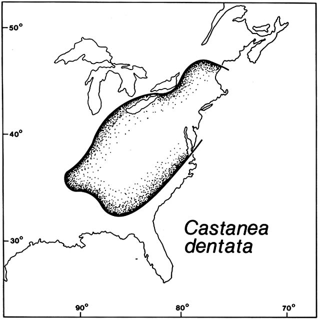
Figure 5. Castanea dentata . The former range of the North American Castanea is shown here before it was
eliminated from the forests by the chestnut blight (adapted from Stevens, 1917). This fungus evolved as a mild
parasite of the Chinese chestnut, following the rule that a successful parasite does not exterminate its host. It
did not follow this rule in North America where it arrived in 1904 with imported Chinese chestnut trees. Its
windborn spores rapidly infected the whole American chestnut population.
the symptoms are mild; on congeneric hosts elsewhere, infection with the fungi is catastrophic.
Chestnut blight arrived in New York in 1904 on Chinese chestnut trees imported as ornamentals for planting in the Bronx Zoological Garden. The spores of the fungus are wind-borne and soon infected the native Castanea dentata , an important member of the hardwood forests over several million hectares of the eastern United States (fig. 5). The tree was valued as a fine hardwood timber, for tanbark, and for the edible nuts. When the trees began dying back on a grand scale, expensive efforts to control the disease were begun. It soon became obvious that there was no hope of stopping the spread of the fungus throughout the range of the host. Attempts to transfer resistance from the Chinese to the American chestnut by standard hybridization and breeding methods were frustrated by the fact that resistant hybrids were ecologically different from their American parent. If introduced to the forests, they would have competed with other native hardwoods rather than reoccupying the chestnut's niche.
Castanea dentata is not extinct in eastern North America because the root systems of trees that have died back continue to send up sprouts, but these are reinfected and killed back again before reaching tree size or reproducing.
Chestnut blight arrived in northern Italy in 1938 and soon spread widely on the European species, Castanea sativa . The situation differed from that in North America in that European chestnut trees are generally planted, commonly as regular orchards, rather than being members of a natural forest. The species was evidently introduced westward from its southeastern European homeland during classic Roman times.
Beginning in 1951, some of the European chestnut trees that had been diseased began to recover; evidently the fungus was being attacked by a disease of its own that reduced its virulence. Research is now aimed at practical methods of spreading this viruslike disease of Endothia and perhaps saving both Castanea sativa and C. dentata .
Dutch elm disease caused by the fungus Ceratocystis , arrived in Europe, by unknown means, before it reached North America. There are several susceptible Ulmus species in both regions. Ceratocystis was first noted in the Netherlands in 1919, soon after in France and Belgium, and by 1927 in England. The fungus is spread by bark beetles of various kinds and thus moved more slowly than the wind-borne Endothia .
Ceratocystis arrived in the eastern United States in the 1930s on elm logs imported from Europe. The native elms are important dominants in floodplain and other moist forests over a huge area. Also, Ulmus americana had been planted over an even wider area as the favorite of all street trees. By 1950 rural and urban elms were dying wholesale from Quebec and Vermont
west to Illinois and south to Virginia and Tennessee. Spread of the fungus was slowed in some urban areas by expensive removal of diseased trees and constant spraying of beetles, but nothing could stop the mortality of forest elms. During the 1950s and 1960s, the fungus spread northeastward into Maine, southeastward into the Deep South and westward to the range limits of wild elms in the High Plains. Beyond there, it spread in town elms through the northern Rockies, reaching Oregon in 1973, northern California in 1975, and southern California in 1978, the end of the trail of elms planted by nostalgic emigrants from the east.
There is some hope of developing biological control of Ceratocystis by injecting elms with cultures of a bacterium antagonistic to the fungus, but this is more likely to save street trees than to bring back the natural stands; their roots are dead, not resprouting like chestnuts.
Panax , Eastern Asia and Eastern North America
(Emboden 1972; Price 1960)
Ginseng, Panax schinseng , has been a legendary plant in Chinese herbal medicine for millennia. Many wonderful powers have been attributed to its root, and it has generally commanded higher prices than any other herb in earth history. The species is native to the shady floor of mature hardwood forests of temperate eastern Asia. Even where uncleared relics of such forests survive, the ginseng is extinct in the wild over much of its native range. However, it has been taken into cultivation, particularly in South Korea, where tens of thousands of persons are currently employed in its production.
A related species, Panax quinquefolia , is native to undisturbed hardwood forests of eastern North America. Early in the eighteenth century, French Jesuits with experience in China organized exports of the American ginseng to China from Canada. Later, ginseng from New England became one of the most valuable cargoes the Yankee clippers had to trade with China. The roots were originally dug mainly by frontiersmen on the fringe of settlements. Later, they were dug from remnant forests, especially in the Appalachians. Not in law but in fact, wild forest ginseng became the property of the finder, regardless of whether it grew on private land, in national parks, or in nature reserves. Some root diggers left young plants and seeds for future harvest, but the species is extinct in much of its former range. Prices have continued to rise, recently to nearly $150/lb. In 1978, the U.S. Endangered Species Authority barred exports of wild ginseng from all states except Michigan, where digging was effectively controlled. Since then other states have started rigorous controls and resumed licensed exports. In 1979, U.S. exports of wild ginseng were valued at about $5 million. Meanwhile cultivation has
begun, mainly based on the Chinese species, which is reported to have been planted in natural forest habitats in the Blue Ridge Mountains once occupied by the American species. U.S. exports of cultivated ginseng in 1979 were valued at about $15 million.
Comment
There are other plants like ginseng that people have sought out individually because of their high value and have exterminated from parts of the original ranges. For example, for centuries extravagant prices have been paid for wood of two unrelated tropical trees, lignum vitae or gayac, Guaiacum officinale , and false gayac, Intsia bijuga . Their woods are among the strongest and hardest known and are also used as a cure for syphilis. Lignum vitae has been eliminated from some of its native dry West Indian forests. False gayac has been eliminated from some Indo-Pacific coastal forests. For example, in the Seychelles it is apparently extinct, and efforts at reintroduction have failed.
When a species is known to be rare, it is especially attractive to plant collectors, including academic botanists. In the Atlas of the British Flora, dots showing locations of very rare species are slightly displaced to frustrate collecting.
Conceivably, introduced insects might selectively eliminate plant species in their native regions in the same fashion that introduced fungi eliminated chestnuts and elms. However, no clear cases are known. The gypsy moth, introduced to Massachusetts in 1869, is still spreading in the United States. It prefers some host trees, for example, Quercus and Prunus , but it is not as specialized a parasite as some fungi. In 1981, the gypsy moth was credited with defoliating 10 million acres of North American forest, but the trees generally recovered and the ranges are apparently unaffected. Cases of elimination of introduced weeds by introduced insects are given in Chapter 4.
4
Artificially Modified
Habitats
Ruderal Vegetation
In the original Latin meaning, ruderals are plants that grow on ruins and rubble. The word will be used here in a broader sense to include weeds of dump heaps, urban wasteland, docks, pathways, railroads, roadsides, and other places heavily impacted by human habitation, industry, and commerce. The term is sometimes defined even more broadly to include all plant followers of humans or colonizers of artificially disturbed sites (Frenkel 1977). Agricultural and pastoral weeds, however, will be considered under other headings below.
Abandoned Villages, Aleutians and Greenland
(Bank 1953, Griffin and Rowlett 1981)
Archaeological sites can commonly be recognized, even in aerial photographs, by distinctive vegetation patterns. A clear example is found in Aleutian villages abandoned early in the nineteenth century when the Aleuts were casualties of Russian fur trade operations. The Aleuts had been primarily marine hunters and fishers with little impact on the tundra of the islands except in their coastal settlements. They built pit houses with stone and earth walls and sod roofs. Today the ruins bear a conspicuously different vegetation than the neighboring tundra. The dominant ruderals are lyme grass, Elymus arenarius , which is native to local beaches, and cow parnsip, Heracleum lanatum , which is native to streambanks.
In Greenland, also, there has been a micromigration of lyme grass from beaches to Viking and Eskimo ruins.
Maya Ruins, Yucatan
(Lambert and Aranson 1982)
Two useful trees, ramon, Brosimum alicastrum , and copal, Protium copal , are so conspicuous on Maya ruins that they have been suspected of being relics from Maya planting. The individual trees, however, are not that old, and it seems likely that the species colonized the sites after abandonment. They are native to nearby dry limestone outcrops; in the archaeological sites, they are concentrated on the steep sides of the highest ruins, built of the local limestone. Their roots often do extensive damage to the masonry.
Roads and Railroads, North America
(Anderson 1952; Baker 1972; Berthoud 1892; Blake 1956; Frenkel 1977; Gill 1973c ; Heiser 1978b ; Mühlenbach 1979; Robbins 1940; Semple 1983; Widrlechner 1983)
In North America, also, various native pioneers were evidently preadapted to exploit sites disturbed by human activities. For example, several annual sunflowers, Helianthus spp., grow wild in coastal sands of Texas, alkali sinks in the California and Nevada deserts, and sandy washes in the High Plains. Berthoud (1892) found sunflower achenes tangled in the coats of bison and the plants growing along bison trails. Some sunflowers spread prehistorically as Indian camp followers. One of these, H. annuus , has a story too complex to discuss here; it involved evolution both as a ruderal and as a domesticate. Helianthus petiolaris has a simpler and more recent migrational history. Until the nineteenth century, it was probably restricted to the High Plains in Colorado. Modern roads opened a pathway through the previously impenetrable vegetation of Kansas and Missouri. From Kansas eastward, H. petiolaris commonly grows in a nearly continuous file along roadsides, not straying into adjacent grasslands or cultivated fields. By 1900, it had crossed the Mississippi and reached Indiana, and by 1960, it had reached the eastern seaboard. Along the way, it became an urban ruderal.
Until 1925, another coarse herbaceous composite, Heterotheca camporum , was confined to prairies and open rocky glades of Illinois and neighboring states. Since then it has spread along roadsides, moving southeastward into Virginia after 1960.
An annual amaranth, Froelichia gracilis , grows wild in open, sandy grasslands
from Colorado and Nebraska south to Chihuahua, and Texas. Until 1920 it was unknown east of the Mississippi; it has since spread, mainly along railroad tracks, into eight eastern states, including New York.
Railroads have been responsible for rapid, often leapfrogging spread of alien ruderals across North America. A dwarf snapdragon, Chaenorhinum minus , which grows wild on European coasts, has long been a widespread weed along European railroads. In North America, it was first recorded at two ports, where it probably arrived in ships' ballast: Camden, New Jersey, in 1874, and St. John, New Brunswick, in 1881. By 1900 it was appearing in scattered places inland, and it has since crossed the continent to both the Pacific and Gulf coasts, being established in hundreds of localities. In each locality, the first record was almost invariably along a railroad; later records have often been along streams that intersect railroads.
The common tumbleweed or Russian thistle, Salsola kali s.l., grows wild on the coasts of Europe and is also a common weed there. It was first recorded in North America in 1886 in South Dakota where flax seed imported from Russia had been sown. (More than one Salsola species may have been introduced to North America, but the species can only be distinguished by specialists and their migrational histories await untangling.) By 1895, Salsola has spread through 16 states and several Canadian provinces and had reached the Pacific coast. The initial spread was mainly along railroads, which simultaneously offered an open habitat and rapid dispersal. The plants are commonly caught in the trucks of the cars and tumble along behind the trains, scattering seed as they go. Salsola is now a familiar ruderal along highways over much of the continent, most abundantly in the Southwest. The California Division of Highways spends over $1 million a year to remove the tumbleweeds from roadsides and drains. Biological control with Eurasian insects is currently being attempted. In 1977 a Pakistani moth was released that is not supposed to feed on beets or native chenopods but only on Salsola and Halogeton , another Eurasian chenopod. The role of Salsola and Halogeton in overgrazed western rangelands is discussed below.
The total ruderal flora of the great railroad yard system of St. Louis, Missouri, has been intensively studied over a 20-year period by Mühlenbach (1979). He found more than 100 species that apparently arrived by train; these had not previously been found within Missouri, although the state is botanically one of the best known in the country. Prominent among the species found were grasses and composites that are common elsewhere in North America, both natives and Eurasian weeds. Most of the species were ephemeral, often disappearing for no apparent reason after successfully flowering and fruiting. The rarest ones, found as single individuals, ended up as pressed herbarium specimens.
Along northern California highways, Frenkel (1977) found that road shoulders had a very simple flora of cosmopolitan herbs, mostly annuals. The
nine most frequent species were all naturalized from Eurasia: Bromus mollis, B. rigidus, Lolium multiflorum, Poa annua, Polygonum aviculare, Spergularia rubra, Medicago polymorpha, Erodium cicutarium , and Plantago lanceolata . Most of these arrived in California during the Spanish and Mexican periods. Only the Spergularia is believed to have immigrated during the twentieth century. Frenkel noted that the limited number of temperate zone species adapted to road shoulders and pathways have spread to form a cosmopolitan ruderal flora in such widely separate regions as North America, Europe, Japan, and Chile. About half of these species have small, hard seeds that are tracked around in soil on feet and tires; most of the rest are adapted for wind dispersal or attachment to animals. None of the common ones have fleshy fruits suggesting internal transport of seeds by animals.
Intercontinental Migration of Pineapple Weed
(Baker 1972; Gill 1973c ; Hegi 1954; Salisbury 1961)
Pineapple weed, an annual composite, is apparently native to both northeastern Asia and western North America. Because of a problem in nomenclature, the species appears in botanical literature under the two names Matricaria matricarioides and Chamomilla suaveolens . Like Helianthus and unlike most composites, pineapple weed lacks adaptation for wind dispersal; the seeds are evidently carried in animal fur and on animal and human feet. Perhaps the species came from Siberia through Beringia to America with prehistoric people and their dogs. It was collected in Idaho by the Lewis and Clark expedition when the region was a wilderness. In the Mackenzie Delta of the Canadian Arctic, pineapple weed grows mainly on riverbank point bars. These are naturally open areas of accreting sandy beaches dotted through the general matrix of bog and forest. These point bars were the traditional campgrounds of Eskimo and Indian canoemen. It is not certain that presence of pineapple weed in such sites depends on human activity because the species is still present 30 years after the sites were last camped in.
Most of the pineapple weed population in western North America, from Alaska to Baja California, is concentrated along pathways and roadsides. On northern California roadsides, Frenkel (1977) found it to be the tenth most abundant species after the nine Eurasian exotics noted above. Its seeds are probably dispersed in mud on tires.
Pineapple weed was introduced to Europe through botanical gardens. It escaped from the Berlin garden about 1850 and was widespread on continental pathways and roadsides by the 1860s. It was introduced to Britain through Kew Gardens in 1869 and escaped within 2 years. Both on the continent and in the British Isles, it continued to spread during the first
quarter of the twentieth century until it became one of the most ubiquitous of all ruderals.
Salted Roads, Mine Dumps, and Bombed Ruins, Britain
(Bradshaw 1983; Matthews and Davison 1976; Salisbury 1943)
A bizarre micromigration was initiated by use of rock salt to melt ice on British roadways. Starting in 1973, halophytes from coastal salt marshes began spreading inland along roadsides, some moving 13 km within 3 years. Species included Suaeda maritima, Spergularia maritima, Plantago maritima , and Aster tripolium ; some are flowering and fruiting in their new sites.
Colonization of British mine and industrial waste dumps is partly by local ruderals but partly by immigrants from a distance. Some plants that pioneer on alkaline lime and soda waste dumps in northwestern England come from calcareous coastal dunes over 40 km away. Some are wind dispersed, such as a gentian, Blackstonia perfoliata , and an orchid, Anacampsis pyramidalis , and some are bird dispersed, such as restharrow, Ononis repens . Some kinds of waste dumps remain barren for centuries. On china clay wastes, there is gradual, orderly development of vegetation and soil, with increasing soil nitrogen evidently controlling the sequence of colonization.
Ruins of British towns bombed during World War II opened sites for population explosions of some ruderals, for example, the circumboreal fireweed or rose bay, Epilobium angustifolium ; the Eurasian groundsel, Senecio vulgaris ; and the Oxford ragwort, S. squalidus . All three have seeds dispersed long distances by the wind and are capable of producing astronomical numbers of seeds. Senecio squalidus is native to rocky places in the mountains of central and southern Europe. It was named by Linnaeus in 1753 from plants cultivated in the Oxford Botanical Garden, where it had been grown since 1699. By 1800 it began volunteering on walls in Oxford. As the railroad network developed in the mid-nineteenth century, the Oxford ragwort began moving along the tracks in clinker ash and stone ballast. By 1930, it was fairly widespread in southern England and some parts of Ireland. Since World War II, it has become one of the commonest ruderals in the British Isles, including the Channel Islands. Curiously, it is only locally present as a ruderal on the continent. The long delay in naturalization and gradual acceleration of its spread suggest evolution of an ecotype adapted to the new region. Also, S. squalidus is highly self-sterile, and the initial introduction may have been incapable of seed production.
The gradual spread of Senecio vernalis on the continent is in some ways a similar case. Senecio vernalis , like its congeners, has light, plumed achenes dispersed by wind. It is an annual, native to the steppes of central and
southern Russia. It moved westward into Lithuania in the eighteenth century, Poland in the early nineteenth, Germany in the late nineteenth, and France in the twentieth century. Its spread has been chiefly on rubble, embankments, and other so-called wasteland (Szafer 1966).
Weeds Imported with Wool and Grain, France and Finland
(Suominen 1979; Thellung 1912)
European botanists have long been drawn to places where imported wool, cotton, and grain were cleaned as good places to find novel exotic plants, sometimes new to science. A classic locale in the study of wool adventives is the French department of Hérault, in which Montpellier lies. Probably no other region of the world has been so carefully studied by plant taxonomists for so long. Since about 1600, a formidable roster of them has worked at the University and Botanical Garden of Montpellier. Thellung, who synthesized the records of adventive plants in this region, was unexcelled as a taxonomist of difficult weedy species.
Thellung (1912) listed 769 exotic species that had been found growing spontaneously in the region since the seventeenth century; many of these were described and named at Montpellier before they were discovered by botanists in their homelands. The richest single source was a wool yard at the Juvenal Gate, where imported wool had been washed for 200 years, starting in 1686. Thellung attributed the introduction of 526 species to seed cleaned out of the fleece. The homelands of the plants matched the source regions of the wool in different periods. Before 1830, nearly all the wool and the associated seeds came from the Near East and other Mediterranean regions. Starting in 1830, the source shifted to the Plata region of South America. Shortly before the wool yard closed, Australian wool and flora were imported. Following closing of the wool yard, the immigrants gradually died out until only 10 species survived there 25 years later. Only four of the wool immigrants had escaped the yard and established weed populations in the surrounding country. Thellung attributed the low rate of survival to climatic incompatibility, which does not seem to be a completely satisfactory explanation.
Of the total of 769 exotic species, 243 were not imported in wool, according to Thellung. He attributed their immigration to escape from cultivation, largely from the botanical garden, imported grain and fodder, ships' ballast, and railroad traffic. Over 100 of these species persisted as reproductive populations, mainly as weeds of artificially disturbed habitats. A disproportionate number of these were North American natives, for example, Phytolacca americana and Amaranthus retroflexus , discussed in Chapter 1.
In Finland, Suominen identified a total of 370 weed species as probably
introduced with imported grain. The study covers the period from 1851 to 1975, so it does not include the many weeds that arrived with grain from the Neolithic to 1850. A massive array of herbarium collections has been correlated, by 5-year intervals, with customs and other records of grain imports.
For a long time after 1850, new weed immigrants were mainly imported with rye and oats from northern Russia. The number of species rose sharply after each Finnish crop failure, when grain imports rose. The adventive weeds grew mainly in the vicinity of flour mills or mill dumps; some grew along railroads and almost none in seaports. Changes in geographic distribution of new ruderals during World War I were correlated with new rail connections and Russian troop movements. During World War II, German troops in Finland were supplied through certain harbors, which temporarily sprouted new immigrant weeds native to central Europe. After World War II, a new set of weeds arrived from the Soviet Union as wheat became the main grain imported; these weeds came from more southern and drier regions than the oats and rye weeds. At the same time, another new set of weeds arrived with large maize and soybean imports from the United States. Most of these were North American natives, such as Datura stramonium, Iva xanthifolia , and Ambrosia artemisiifolia , and some were European weeds naturalized in America, such as Abutilon theophrasti . Imports of Argentinian maize and Australian wheat brought mainly naturalized European weeds, not natives of the southern hemisphere. A local outburst of southern European weeds was tied to a particular shipment of Turkish oats. After 1953, imports of Chinese soybeans brought Setaria faberi , a weedy grass common in fields in China.
The vast majority of the colonies were ephemeral and confined to the mill dumps and other spots where the imported seeds landed. None of the immigrants from southern Europe or overseas were able to reproduce under Finnish climate and day lengths. The minority of new immigrants that did reproduce were almost all from Russia. These did not generally become field weeds but rather remained strictly ruderal, commonly in urban sites with warm, dry microclimates and nonacid soils. Among these precarious immigrants are species that are less demanding weeds in lower latitudes, such as Solannum nigrum, Hyoscyamus niger , and Sonchus asper .
Comment
By definition, ruderal habitats are human creations, but the importance of human seed dispersal in migrations of ruderals is highly variable. It was probably irrelevant in occupation of Aleutian, Mayan, and British ruins. In
the cases of roadside and railroad weeds, human dispersal may have merely accelerated the rate of migration. It was crucial for overseas migrations. Such long-range dispersal has often resulted in ruderal colonies that are unable to maintain themselves. It is commonly considered a trivial pursuit for botanists to record such ephemeral colonies. If the roles of dispersal and environmental selection in plant migration are to be properly evaluated, however, a balanced record of failures and successes is needed. If only successful colonization is considered, it is easy to forget the role of environmental selection and to assume that species are absent from distant regions because they have been unable to get there. Moreover, when a botanist finds a new immigrant, whether it is at a dead end or the founder of a great invasion may be unpredictable.
Ruderal populations have sometimes served as migrational bridges between other habitats, including natural seashore and riparian habitats where many ruderal species originated. For example, Amaranthus rudis , native to stream banks of the south-central United States, began appearing in European ports and railway yards as a trivial ruderal about 1950. It has since moved from Italian railways into natural riparian habitats along the Po River.
Weeds Of Cultivated Ground
Transcontinental and Intercontinental Migrations of Amaranthus
(Sauer 1967a )
Amaranthus is a cosmopolitan genus of annual herbs that includes about 50 species native to stream banks and seacoasts of many temperate and tropical regions. Some of the New World species became especially successful and widespread as agricultural weeds; the migrations of three of these will be sketched here. These three species are native to regions where maize was cultivated before Columbus arrived in America. In traditional American Indian agriculture, maize was interplanted with other crops in milpas, which were treated more like gardens than like Old World small grain fields. No weed seeds rode along on maize ears selected individually for seed grain, which was hand planted in hills that were hoed and hand weeded. Nevertheless, amaranths thrived and spread as milpa weeds. Farmers tolerated them as favorite sources of potherbs and edible seeds and eventually domesticated some amaranths as ancient grain crops, a story that is not relevant here. A healthy amaranth plant produces thousands of seeds, which in the weed
species, germinate gradually over decades whenever the soil is disturbed.
Amaranthus hybridus s.l. (including A. quitensis ) grows wild on riverbanks from eastern North America through the highlands of tropical America to temperate South America. It very likely became a milpa weed in Guatemala or Mexico when maize was first domesticated. It did not accompany maize to Europe in 1493, but finally arrived by means unknown in the early eighteenth century. During the nineteenth century, it became an abundant weed in southern Europe and northern Africa mainly in agricultural land, including maize fields; occasionally it escaped to river banks. North of the Alps, it has appeared repeatedly as an ephemeral ruderal but does not reproduce there. About 1900, A. hybridus appeared in California, South Africa, the Far East, and Australia and has continued to spread as an agricultural weed. In New South Wales, it has become much more abundant since 1960.
Amaranthus retroflexus grows wild on streambanks in eastern North America, as noted in Chapter 1. It is also a common weed in floodplain maize fields. In the mid-eighteenth century, Peter Kalm sent seeds from Pennsylvania to Linnaeus; a specimen grown at Uppsala, the type for the binomial, is still preserved in the Linnaean Herbarium in London. Linnaeus may have been responsible for inoculating Europe with the species by sending seeds to various botanical gardens. Lamarck noted it had escaped at Paris by 1783. By 1800, it was a common agricultural weed throughout much of the continent. Collections in major European herbaria show that during the nineteenth century, A. retroflexus spread as far as Norway, Portugal, the Azores, Algeria, Greece, Turkey, Syria, Astrakhan, and Afghanistan. Recently, Conard and Radosevich (1979) noted that maize yields in Italy and Austria were being seriously reduced by infestations of A. retroflexus that had developed atrazine resistance due to overuse of the herbicide. About 1900, A. retroflexus appeared in California and since then has arrived in China, Japan, and Australia. In New South Wales, it has become widespread since 1950.
Amaranthus powellii (including A. bouchonii ) grows wild in arroyos and desert washes in the Cordilleran system from western North America to the Andes. It was also a prehistoric milpa weed. In California and other far western states, as agriculture expanded in the nineteenth century, A. powellii became the most common weed amaranth in the region. It began to spread east of the Rockies about 1900 and has become a troublesome weed of maize and soybeans in the U.S. corn belt since 1940. Overseas, it showed up sporadically from the 1890s through the 1920s in Europe at scattered places from Scotland to Spain and from Sweden to Austria. For a long time, it remained a ruderal around docks, wool waste dumps, tanneries, grain elevators, and railroad yards. Since 1930, it has become a common weed in maize, potato, and other crops in the British Isles and on the continent; it reached Turkey after 1960. Meanwhile, A. powellii appeared in Australia, New Zealand,
and southern Africa in the late nineteenth century; only recently has it become abundant there. In East Africa, it first appeared in 1949 as a maize weed in Kenya. It invaded southern India after 1960.
Comigration of Cereal Crops and Weeds to California
(Barrett 1983; Robbins 1940)
Old World small grain agriculture, since its Neolithic origins, has depended on mass harvesting and sowing of seed from a mixed population of more or less domesticated cereals and associated weeds. Spanish wheat fields contain such mixtures today. During the colonial period, Spanish weeds inevitably went along with wheat to the New World. Eventually, perhaps via both Mexico and Chile, Spanish wheat and weeds even reached California. The eighteenth-century adobe bricks of California missions contain seeds of black mustard, Brassica nigra , and other European weeds that probably were accidentally carried in the seed wheat. Curiously, the red poppy, Papaver rhoeas , one of the most common Spanish grainfield weeds, has not naturalized in California wheat fields, although the species is grown as an ornamental.
Rice cultivation began in California with seed introduced from Japan in 1912–1915. Various Japanese rice weeds still grow around the Sacramento Valley experiment station where rice was first planted. Some of these weeds have not spread from there. Two species of barnyard grass, Echinochloa oryzoides and E. phyllopogon , which evidently came with the imported rice seed, have spread as major weeds throughout California rice fields. A close relative, E. crus-galli , also native to Asia, arrived in California earlier; it has been a common weed there since the mid-nineteenth century in various crops. Echinochloa oryzoides and E. phyllopogon are almost entirely confined to flooded rice fields. They are believed to have evolved as weed mimics of rice in ancient paddies. Hand weeding caused any genetic changes that made the weed harder to eliminate from the crop to be favored by unintentional selection.
Both species now have seedlings that look almost identical to rice seedlings; both flower and mature their grain synchronously with rice. The seeds are not as heavy as rice but are two to three times as heavy as ordinary E. crus-galli seed. They resemble rice closely enough to pass inspection in certified seed. Both species produce seed with weak dormancy that germinates fully along with planted rice, unlike E. crus-galli . Also like rice and unlike E. crus-galli , the weed mimics are adapted to conduct O2 from the air down to flooded root systems. In retrospect, immigration of these weeds could have been barred by meticulous seed sorting, but they passed routine screening.
Sequential Migration of Glycine and Setaria from China
to North America
(Fairbrothers 1959; Pohl 1951)
A species of bristlegrass, Setaria faberi , noted above as having arrived in Finland with soybeans imported from China, arrived in North America long after the crop. Soybeans were introduced repeatedly from 1765 to 1900, but did not become an important crop until World War I when a phenomenal expansion began that culminated with their regular rotation with maize throughout the U.S. corn belt.
The first record of Setaria faberi in North America was on Long Island, New York, in 1925. During the next 20 years, it spread east of the Appalachians along railroads and roads and in scattered urban sites from New England to the Carolinas. For a long time, it was not recognized as distinct from a related weed, Setaria viridis , which had arrived long before.
Setaria faberi ceased to be a minor ruderal and became a major agricultural weed when it finally reached the corn belt. It was first recorded in Illinois in 1941; by 1950 it was exceedingly abundant across Illinois and Indiana, frequently blanketing soybean fields so densely that the crop could hardly be seen. It was first recognized in Iowa in 1949, and by 1950 it was in 36 Iowa counties and had spread to neighboring states. It grows as an annual in both phases of the standard crop rotation, but is more of a problem in soybeans than in the taller maize.
Comment
Human dispersal of weed seeds may be irrelevant in some situations, as where riparian species are preadapted to colonize cultivated ground within their natural seed shadows. Human dispersal was obviously crucial in cases of weed migration overseas, as in the case of Setaria faberi , and weeds have commonly gone abroad as stowaways in shipments of grain or cotton. Another pattern, not discussed above, is escape of a deliberately introduced crop to become a noxious weed. For example, Tientsin jute or velvetleaf, Abutilon theophrastii , was a fiber crop, domesticated in Asia, which was introduced to the British colonies in North America. Before American cultivation was abandoned in the late nineteenth century, Abutilon had been widely planted by corn belt farmers. It survives there as a major weed of both maize and soybeans, resistant to herbicides and causing losses of hundreds of millions of dollars annually (Spencer 1984). Similarly Johnson grass, a variety of Sorghum halepense , has been widely planted in North America as a fodder crop and has escaped to become a troublesome weed in other crops.
In Central America in 1960, a Mennonite colony struggling to establish itself in Belize planted Johnson grass for the dairy cattle, setting in train a permanent weed problem. The seeds are spread by birds and cattle and invade new land as fast as the forest is cleared (Sawatzky 1971).
Regrowth On Abandoned Fields
Piedmont, North Carolina
(Billings 1938; Christensen and Peet 1981; Egler 1954; Finegan 1984; Keever 1950)
By the mid-nineteenth century, most of the Piedmont region east of the Appalachians was under cultivation for row crops and the rest was exploited for timber and grazing. The native pines and hardwoods retained their former gross ranges but only as patchy remnants. Thereafter, farms were progressively abandoned due to soil exhaustion and economic depression. Because of the drawn out chronology of abandonment, Billings (1938) and other workers were able to compare different ages of regrowth on otherwise similar sites to develop a model of secondary succession that has become a textbook classic.
The native flora and its seed bank in the soil had evidently been exterminated from the fields by long continued cultivation. The dominant species in the study area the first year after abandonment was European crabgrass, Digitaria sanguinalis , which had been present as an agricultural weed. Native pioneer herbs and trees, all with primary populations in riparian and other naturally open habitats, began to invade when their first seed ripened after the last cultivation. Native composites with wind-borne seeds built up populations quickly, first with annuals, such as Conyza canadensis and Ambrosia artemisiifolia , and next with perennials, such as Aster pilosus . By the third year, seedlings of a perennial grass, Andropogon virginicus , began to crowd out the composites. Meanwhile, yellow pines, Pinus echinata and P. taeda , rapidly seeded in, and by the fifth year the dense stand of pine seedlings began to shade out the pioneer herbs. Thus far, the sequence of invasion was evidently controlled by availability of seed rather than by a relay in which early arrivals prepared the site for following species. It was believed, however, that invasion by hardwood trees was delayed until about 20 years after abandonment, when the accumulation of pine litter and humus finally permitted Quercus seedlings to survive. Further development of canopy and soil were supposed to be prerequisite to entry of other hardwoods.
Later workers have suggested modification in the scheme of hardwood succession. In some places, the pines were accompanied from the start by wind-dispersed hardwoods, for example, Liquidambar styraciflua, Liriodendron tulipifera , and Acer rubrum . Various species of Quercus and Carya may also have colonized promptly if there was a nearby seed source. They may be absent from most young stands because of lack of dispersal. Transport of their heavy acorns and hickory nuts may await buildup of animal populations with forest development. Christensen and Peet (1981) suggested that abandoned fields are so fully stocked by rapidly arriving wind-dispersed trees, mainly pines, that more slowly dispersed species cannot invade until the pioneer forest begins to degenerate and thin out.
The process of hardwood forest regrowth in the Piedmont is becoming of mainly academic interest because of a general trend to plantation pine monoculture for pulpwood production.
Cat Island, Bahamas
(Byrne 1980)
Shifting cultivation has been practiced intermittently on Cat Island for about 1,000 years, with a hiatus for about 200 years after the original Arawak inhabitants had been exterminated by the Spanish. The present pattern developed during the British colonial period in the eighteenth century. Fields averaging about 0.1 ha in area are partly cleared in the evergreen scrub woodland covering most of the island; a few shade trees are left. After the slash is burned, many of the stumps resprout and much time is spent the first year removing the sprouts. More effort is spent on herbaceous weeds during the second and third years, after which the field is abandoned. Regrowth is usually allowed to develop over 15 years before reclearing, often over 30 years.
Byrne (1980) conducted an elegant study of shrub and tree regrowth on 300 former fields. The age of the vegetation was determined from successive aerial photographs and groundwork with local informants. The farmers distinguish three kinds of terrain: whiteland, blackland, and flatland, which Byrne identified, respectively, as Holocene beach ridges and dunes, Pleistocene beach ridges and dunes, and Pleistocene marine plains.
Within the first 15 years after abandonment, whiteland fields were invaded by about 15 woody species and the blackland and flatland by over 80 each. Nearly all the species are native to coastal and other naturally open habitats on the island. The only important old field pioneer that is an exotic is Leucaena latisiliqua , a mimosa-like shrub or small tree that was introduced from the tropical American mainland; on Cat Island it is common along
roadsides. A few of the early regrowth species probably survived clearance and cultivation, either vegetatively or as buried seed, but most evidently seeded in. All species are well adapted for local dispersal, mostly by wind, such as Gundlachia corymbosa , and a few by birds, such as Lantana involucrata .
From about 15 to 30 years after abandonment, some of the pioneer shrub species were replaced by taller shrub and tree species. Most of these were present in the early regrowth phase and simply increased in cover. Other tree species invaded only after the vegetation was more than 15 years old, including Metopium toxiferum on blackland and flatland and Coccoloba uvifera on whiteland. In Chapter 1 it was noted that the Coccoloba was slow to recolonize Belize cays where it had been dominant before being wiped out by a hurricane. These later invaders are bird dispersed.
Byrne (1980) pointed out the remarkable contrast between the very limited role of exotic plants here and their overwhelming invasions of disturbed habitats on some other islands. The Bahamas had a rich flora adapted to droughty, sandy, and rocky terrain that is geologically young and naturally disturbed by hurricanes, lightning fires, and dune formation. Evidently this flora was preadapted to exploit temporary human clearings.
Upper Amazon Basin, Peru
(Scott 1978)
Traditional Campa Indian agriculture continues in the Gran Pajonal region of eastern Peru. Unlike so much of the humid tropics, this region is not being converted to pasture for beef cattle. Campa Indian population is not increasing, and about 97% of their region is currently covered with semievergreen forest. Shifting cultivation involves small clearings in mature forest, which are burned during the short dry season and planted with maize, manioc, and a variety of other plants. Most of the forest species are eliminated from the milpas, if not by cutting and burning, then by pulling resprouts and seedlings. Some weeds germinate even before the rains, probably from seed that was dormant in the forest soil, for example, Phytolacca rivinoides and Passiflora coccinea . Both of the species are bird dispersed, and the Phytolacca is known to be capable of long dormancy until released by soil disturbance. Other weed species, largely wind dispersed, appear within a few months. Very abundant are bracken fern (Pteridium aquilinum ); grasses, including Imperata brasiliensis ; shrubby composites, including Baccharis floribunda ; and fast-growing trees, including Cecropia spp. All these pioneers have local populations on stream banks, anthills, or other naturally open sites and are not dependent on seed from other milpas.
After 2 to 3 years, the milpa is usually abandoned to the weeds, and Cecropia trees soon dominate with an understory of shrubs, mainly melastomes. The bracken and grasses are gradually shaded out. After 25 or 30 years, the Cecropia trees die out, and a few saplings of primary forest trees recolonize the area.
This cycle can be sidetracked and stalled if the abandoned field is burned annually. The Campa sometimes deliberately create new grassland patches on former fields by firing them each dry season. This initially favors the Imperata over other weeds and forest regrowth, but as the years go by, the stoloniferous Imperata is gradually replaced by Andropogon spp. and other bunch grasses. The new savanna is then invaded by fire-tolerant shrubs, particularly Byrsonima crassifolia , which is dispersed by birds. The Campa grassland—forest borders are extremely abrupt; the fires normally go out without penetrating the forest. Some bird-dispersed shrubs that are not adapted to either frequent burning or shade survive along the forest margin, including Lantana camara, Rubus urticaefolia , and various melastomes. The Campa do not keep cattle, and they value grassland patches mainly as settlement sites. Settlements migrate every few years, usually rotating among several sites on grassy ridges that offer a view, exposure to sun and wind, and escape from mosquitoes and snakes.
Where non-Indian settlers with livestock enter the region, the Campacreated grasslands are overgrazed and fire frequency and intensity are reduced. The old field succession then resumes; Baccharis floribunda and other wind-dispersed composites return, along with bird-dispersed shrubs and small trees, especially Lantana camara, Psidium guajava , and melastomes.
Tall Forest Regions, Philippines
(Brown and Mathews 1914; Conklin 1957; Holm et al. 1977; Kellman 1970)
Traditional swidden or shifting agriculture in the dipterocarp rainforests and tall seasonal forests of the Philippines relies on a long fallow period during which the forests substantially recover. Even in small, temporary clearings, the primary forest species are usually completely killed out by burning and weeding. During cropping, the weed flora consists mainly of grasses and other herbs. By the second year after abandonment, pioneer trees, mainly bird dispersed, are seeding in. The species are not those that colonize treefalls in mature forest. The seed must come either from wild stands on coastal, riparian, or landslide sites or from other abandoned swiddens. Common pioneer trees include Trema orientalis in the elm family and various species of Homalanthus, Macaranga , and Mallotus , all in the euphorb family.
All are soft wooded and rapid growing; they retain dominance for about 25 years before the reinvading primary forest trees take over.
Here again, a typical cycle can be shunted onto a sidetrack by repeated burning of the regrowth. This commonly begins in swiddens that have been invaded by cogon grass, Imperata cylindrica , and wild sugarcane, Saccharum spontaneum , species discussed above as common on Krakatau and in riparian sites in Malaysia. The abundant plumose seeds of these grasses may blow in the wind for long distances over land and sea, but they drop out of the still air under a forest and seldom find their way to isolated clearings. They spread easily between nearby clearings along paths and roads. Their aggressive growth and spread by tough rhizomes are among the main reasons for field abandonment. If ignited, these grasses burn fiercely even when green; their rhizomes survive while tree seedlings that would otherwise eventually shade the grasses out are incinerated. The fires normally go out right at the forest margin, even in regions with a dry season, so the burning itself does not cause advance of these artificial savannas into undisturbed forest. Imperata and Saccharum are often fired deliberately to maintain them as fresh forage for deer or cattle. Also, as human population pressure has risen and the swidden cycle has been shortened, accidental burning has become common and self-reinforcing. The spread of these artificial savannas has been partly channeled by topography; they are expanding most rapidly on ridges and hillcrests most exposed to fire.
Comment
Finegan (1984) noted that theories of forest succession, particularly on old fields, have suffered from a pendulum swing from one extreme to another, with positions based mainly on deductive logic rather than field observation. Rather than choosing between polar positions that the succession is controlled by either autogenic changes in the environment or by vagaries of seed dispersal, he suggests that a less inflexible theory would allow for the possibility of control by both. Both certainly need to be considered in accounting for the sequence of species invasion in the few cases discussd above.
Whatever factors control the sequence of colonization, there is no doubt that local migration is involved. Abandoned fields are invaded from outside rather than reclaimed by species surviving in situ from a previous cycle; this appears to be true of both the weedy pioneers and the late stages of forest succession. However, in long fallow-shifting cultivation where only a small percentage of the forest is cleared at a time, the pioneers may have to immigrate from farther away than the forest regrowth species.
Ecology textbooks usually lump old field regrowth under secondary succession together with regrowth after blowdowns, fires, and other natural
disturbances or perturbations. This makes secondary succession a messy concept because old field succession approaches a primary succession model in starting with a clean slate and requiring invasion, while the other natural kinds of secondary succession approach an initial floristics model with all the species present on the site from the outset.
Altered Rangelands
Cattle and Sheep, Great Basin of Western North America
(Burkhardt and Tisdale 1976; Christensen and Johnson 1964; Lanner 1981; Mack 1984; Madany and West 1983; Robertson 1971; Rogers 1982; Vale 1974, 1975; West 1983; Yensen 1981; Young and Budy 1979; Young et al. 1972, 1976)
The high, arid intermountain region of western North America has cold, snowy winters and hot, dry summers. Under original pristine conditions, salt flats in the valley floors, where they were not completely barren, had scattered greasewood, Sarcobatus vermiculatus , and other chenopod shrubs. Vast areas on lower slopes around the basins were dominated by less extremely halophytic chenopod shrubs, for example, shadscale, Atriplex confertifolia ; wing-scale, A. canescens ; and winterfat, Ceratoides lanata . At slightly higher levels, big sagebrush, Artemisia tridentata , dominated tens of millions of hectares; it was commonly accompanied by rubber rabbitbrush, Chrysothamnus nauseosus , and other shrubs. At still higher elevations, big sagebush was joined by junipers, and still higher, by pinyons. Juniperus osteosperma and Pinus monophylla were the most widespread of these scrub conifers. Above the scrub conifer woodland in the highest mountains were forests of tall conifers.
The region also had native grasses. Meadows along streams carrying snowmelt from the mountains had a tall perennial wild rye, Elymus cinereus . Among the scattered sagebrush and the scrub conifers grew sparse perennial grasses, such as Agropyron spicatum, Poa secunda, Sitanion spp., and Stipa spp. The grasses aestivated during summer and the dried grass sometimes burned. Most grasses were not killed by fire, but sagebrush, junipers, and pinyons were. Fires did not generally spread far before being stopped by lack of fuel, especially on steep slopes and rocky ridges. Thus, burns created a patchwork of different-aged stands of sagebrush and woodland.
The vegetation was probably originally in near equilibrium with the native herbivores. Bison were few, in contrast to the great herds east of the Rockies. Other ruminants—mule deer, pronghorn antelope, and bighorn sheep—were present in limited numbers. Their facultative browsing and
grazing put little pressure on the vegetation. Rabbits and rodents were generally more important plant consumers.
The Indian inhabitants of the region were hunters and gatherers. They harvested plentiful crops of wild rye and pinyon nuts. There is no evidence that they had a significant effect on the vegetation.
Mormon settlements, starting at Great Salt Lake in 1847, rapidly fanned out through the region seeking irrigable land for intensive subsistence farming. Mormon livestock culture initially followed the North European pattern: community milk and meat cattle, draft animals, and sheep were kept in the settlement at night and herded nearby during the day. The result was severe but very localized overgrazing.
Extensive commercial livestock production developed in the Great Basin from different roots, that is, the Spanish American pattern of open range without fences or stored feed. It was stimulated by the mining booms and demand for meat in California after 1849, in Nevada's Comstock Lode after 1859, and by subsequent mining strikes. The areas of old Spanish settlement in California and New Mexico provided a source of cheap, abundant cattle and sheep to found the Great Basin herds. The range was free and belonged to those who got there first. Except during annual roundups, cattle and reserve horses were essentially free-ranging feral animals. Sheep were herded in large flocks, initially often without a home ranch. Itinerant sheepherders claimed as much right to free grass as anyone and drove their flocks wherever the grazing was best.
Initially, there was enough grass so that livestock could survive normal winters on the open range without unacceptable losses. However, overstocking and recurring droughts during the 1870s and 1880s greatly depleted the grass. In the severe winter of 1889–1890, over 250,000 head of livestock died on the ranges of northern Nevada alone. A new pattern then developed based on home ranches on streams with meadows supplying hay for winter feed for cattle and some sheep. Ranchers who had homesteaded the valley meadows inherited use of the surrounding open rangelands, theoretically federal property. The natural meadows were expanded by irrigation. The Indians commonly became hired hands on the ranches. Instead of harvesting wild rye and pinyon nuts, they fed hay from their ancestral meadows to cattle and cut pinyon and juniper trees for ranch firewood and fence posts. Some itinerant sheep operations still owned no home ranches and wintered the flocks in the lower elevation shadscale deserts.
In spite of occasional setbacks, livestock numbers continued to build up until early in the present century. Between 1900 and 1920, Nevada had an average of over 1,200,000 sheep, 400,000 cattle, and 70,000 horses. Feral horses kept grazing pressure on open ranges in winter, when ranches were feeding cattle at home. Since then, cattle numbers have fluctuated around the same level, while sheep and horse numbers have dropped precipitously to about 200,000 and 20,000, respectively. Droughts and depression in the
early 1930s wiped out most of the large sheep operations. Finally, in 1934 Congress passed the Taylor Grazing Act, under which 70 million ha of federal land in the western United States, including 71% of Nevada, were withdrawn from unrestricted open range and organized into controlled grazing districts. By then much of it had been reduced to nearly pure stands of unpalatable brush. Much of it was so degraded that even where grazing had been completely excluded for over 30 years, little recovery of forage production has taken place. It took less than 90 years for ranching and sheepherding to irreversibly alter the region's plant geography by unintentionally caused local and long-range plant migrations.
The most catastrophic retreats have been by native grasses, while the greatest advances have been by exotic grasses and weedy dicots. The wild rye, Elymus cinereus , in meadows along streams did not survive well under either grazing or mowing for hay and has been largely replaced by irrigated alfalfa, Medicago sativa , and Kentucky bluegrass, Poa pratensis , both natives of Eurasia. On the open range, whatever grasses are now present are predominantly Eurasian annuals with a long history of survival under intense grazing. The most abundant of these is cheatgrass or downy brome, Bromus tectorum ; it was first observed in the region about 1900 in western Nevada. The seed evidently was brought in the coats of sheep driven from California, where cheat had arrived a few years earlier. Unpalatable when mature, cheat has spread to fill the vacuum left on millions of hectares by removal of the native perennial grasses. This substitution appears to be permanent. Even in stands where remnants of the native grasses survive and livestock have been excluded for over 50 years, the natives do not displace cheatgrass. Another unpalatable Eurasian annual grass, Medusahead, Elymus caput-medusae , was also apparently brought from the Pacific coast in the coats of sheep. Arriving in the Great Basin in the 1930s, it spread rapidly in heavier soils than cheatgrass. It is still spreading in overgrazed areas, but in some areas where grazing has ceased, it has been replaced by a native perennial grass, Sitanion .
Various Eurasian annual dicots have also invaded the region. As noted above in Chapter 4, Salsola spread throughout the western states as a railroad ruderal. Accompanied by another Eurasian tumbleweed, Sisymbrium altissimum, Salsola fanned out into rangelands. Salsola obviously benefits from soil disturbance and removal of competition by grazing. A related chenopod, Halogeton glomeratus , was an obscure wild species in deserts east of the Caspian Sea until it showed up as a ruderal near Wells, Nevada, in 1934. It had spread widely along roads and in rangelands before it was recognized as toxic to sheep; it has killed thousands of sheep in the Great Basin. Halogeton now grows on millions of hectares of overgrazed Atriplex confertifolia and Artemisia tridentata rangeland. Halogeton leaf litter enriches the soil surface with salt, which favors its own seedlings over competitors.
Some of the palatable native shrubs have stories parallel to the native grasses. Formerly abundant species of Atriplex and Ceratoides that once supported
ported many sheep are now gone from large areas. Other native shrubs have had more complex changes in distributions, as have pinyon and juniper. They have been buffeted by changes in the fire regime more than by direct effects of browsing. When domestic livestock were first brought into the region, fire frequency may have been increased deliberately, especially by sheepherders, to stimulate grass; the woody vegetation may then have lost ground. Also, the Comstock Lode and later mining operations within the region consumed vast quantities of pinyon and juniper wood for mine timbers, fuel to power machinery, and charcoal for smelting. By the time mining collapsed late in the nineteenth century, trees had been stripped from country around mining centers up to an 80-km radius. How much effect this exploitation had on pinyon and juniper geography is uncertain; seedlings and saplings must have survived.
Meanwhile, as grass was lost from overstocked rangelands, fire could no longer spread. Unrestricted by fire and unbrowsed, big sagebrush spread where more palatable shrubs had been removed. So did junipers, pinyons, and other conifers where they were not being cut.
With the arrival of cheatgrass, the situation in the area it invaded was again reversed. The ungrazed mature grass was commonly dense enough to carry fires that killed patches of sagebrush, pinyon, and juniper. Also, after World War II, extensive areas of sagebrush and pinyon—juniper woodland were killed with herbicides or crushed and uprooted with heavy equipment to destroy the woody vegetation in an effort to increase grass production. Between 1960 and 1972, about 150,000 ha of woodland in Nevada and Utah were destroyed with heavy chains dragged between tractors by the U.S. Forest Service and the Bureau of Land Management. There was no hope of bringing back the native grasses, so the chained areas were generally seeded with Eurasian perennial grasses. Management of federal lands in the Great Basin has become very sensitive politically, with cattlemen and environmentalists in polar positions on continuation of grazing. The cattlemen have a great asset in the popular view of cattle grazing as part of the romantic western tradition. Few people except range scientists are aware of the impact of grazing on the Old West.
Feral Livestock, California Channel Islands
(Brumbaugh 1980; Coblentz 1978; Dunkle 1950; Goeden and Ricker 1981; Goeden et al. 1967; Hobbs 1980; Johnson 1980; Minnich 1980, 1982; Philbrick 1972, 1980; Raven 1963; Thorne 1969; Westman 1983)
After the prehistoric extinction of pygmy mammoths, the vegetation of the islands off the southern California coast was untouched by large herbivores before the introduction of livestock in the nineteenth century. The only
terrestrial mammals were rodents, skunks, and diminutive foxes, all of which may have ridden in the seagoing canoes of the Chumash Indians who frequented the islands. The islands were never connected with the mainland, but during glacial low sea stands, the channel separating some of them from the mainland was only a few kilometers wide and presumably easily swum by the elephants.
The rich native flora included many endemic species, some of which are believed to have originated on the islands by adaptive radiation. Others are survivors of once widespread species known only as fossils on the mainland, such as island ironwood, Lyonothamnus floribundus , and island oak, Quercus tomentella . Many of the native island species are conspecific with those on the nearby mainland, although it has been suggested that shared chaparral shrubs evolved more arborescent forms on the islands. This so-called island gigantism may be an artifact of grazing and browsing by feral sheep and goats. Their voracious consumption of plant material reduced fuel and prevented chaparral burning, which was probably always less frequent than on the mainland because of the maritime climate. The chaparral shrubs thus have prolonged lives while being trimmed up to tree form by browsing.
Each of the eight major islands has had a different history of livestock introduction. Four will be sketched here.
San Miguel is the westernmost and most windswept of the islands. It is rather low and most of its 37-km2 surface is covered with Pleistocene dunes. In Holocene time, these had been stabilized by a cover of coastal sage scrub and grass. In the mid-nineteenth century, the island was stocked with over 6,000 sheep and some cattle and horses. During 3 years of drought in the 1860s, nearly all of these starved to death. Overstocking continued, and during subsequent droughts over half of the island became a waste of drifting sand. Regrowth during wet years was mainly by grass and other herbs. The number of sheep was finally reduced to about 3,000 in the 1930s and most were removed in 1950. After the National Park Service took over the island, the remaining sheep were shot in 1968 and feral burros were removed in the 1970s. Successive aerial photographs show gradual revegetation of some of the dunes since 1960. However, the original coastal sage scrub and grass vegetation has not recovered. Some recolonization is by a native morning glory vine, Calystegia macrostegia , found on coastal bluffs on the islands and mainland. Much of the colonization is by the perennial Australian ice plant, Mesembryanthemum aequilaterum , discussed in Chapter 1.
Santa Cruz is the largest and most rugged of the islands, with an area of 250 km2 and peaks up to 750 m high. Cattle, horses, sheep, and pigs were introduced in the mid-nineteenth century. Cattle and horses have remained under control, mainly in valley grasslands and on gentle slopes. Vegetational changes there are much like those that began earlier in mainland grasslands. The native perennial bunchgrasses have declined under grazing and have been mostly replaced by annuals. Some of the annuals are unpalatable natives,
such as doveweed or turkey mullein, Eremocarpus setigerus , probably originally confined to intermittent watercourses, and a tarweed, Hemizonia fasciculata , which may have been a member of the original grassland. The cattle and horse pastures are now dominated by European annuals, among the most common being a wild oat, Avena barbata ; brome grasses, such as Bromus mollis, B. rubens , and B. diandrus ; filaree, Erodium cicutarium ; burr clover, Medicago polymorpha ; cat's ear, Hypochaeris glabra ; and milk thistle, Silybum marianum . The pastures have also been heavily invaded by a European perennial, Foeniculum vulgare (fennel), which was introduced to California as a culinary herb and has spread widely as a ruderal. On Santa Cruz Island, it dominates pastures near the boat harbor and ranch house. Although eaten by cattle when young, it is evidently unpalatable when flowering. It is currently spreading rapidly, not only in pastures but under scrub oak woodland that appears undisturbed. As on the mainland, cattle have had relatively little impact on the native scrub and woodland vegetation.
Sheep have had far more impact on Santa Cruz Island scrub, both coastal sage and chaparral, and on woodland, both hardwood and pine. By 1870, the island had about 45,000 sheep and by 1875, about 60,000. They were allowed to run free and only about half could be rounded up for shearing annually. Tens of thousands were slaughtered during drought years to prevent total desertification and starvation. Feral pigs also became abundant during the late nineteenth century and prevented reproduction of both scrub oaks and woodland oak trees by rooting for acorns. Late nineteenth century accounts and photographs record progressive destruction of coastal sage and other vegetation and increasing erosion. In the bare areas, a cactus native to coastal bluffs, Opuntia littoralis s.l., spread inland. Most of the denudation took place during the late nineteenth century. Since aerial photographic coverage began in 1929, there has been little further attribution of woody vegetation except near the eastern tip of the island, which continues to be operated as a sheep ranch.
Starting in 1939, the Stanton Ranch, which had acquired all but the eastern tip of the island, began trying to eliminate the sheep. Tens of thousands were shipped to market and tens of thousands of others that could not be caught were shot, along with innumerable pigs. During the 1950s, the Stanton Ranch built a huge network of fences to control the cattle and exclude sheep and pigs from large portions of the island. The fences are often broken through by pigs and by floods in stream channels, so the feral sheep and pigs are seldom completely absent for long. However, the vegetation contrast across some fence lines is dramatic. In wet years, the contrast is less striking because of temporary cover by European annuals in the sheep country. Generally the sheep side of the fence has much more bare ground, browsed shrubs, and no young trees.
Since the 1929 photographs were taken, a stand of bishop pine, Pinus muricata , in sheep country on the north side of the island has decreased
greatly in density. The trees are all 40 to 70 years old with no seedlings or saplings; the average life span of a bishop pine is about 65 years. Two other bishop pine stands on the island had no seedlings and also faced extinction before sheep were fenced out in the 1950s. Pine reproduction is now abundant in various age classes. Reproduction of other native trees and shrubs is virtually nil in sheep country, with a few exceptions, including an unpalatable bush groundsel, Senecio douglasii .
The Nature Conservancy is in the process of taking over the Stanton Ranch and faces the formidable task of eliminating feral livestock. It is probably already too late to save some species, for example, an endemic monkey flower, Mimulus brandegei , first seen in 1888 and last seen in 1932.
The invasion of the interior of Santa Cruz Island by the coastal Opuntia littoralis has been reversed by a biological control program, the oldest one in North America and the only one anywhere to successfully control a native weed with purposely introduced insects. In 1939, an estimated 40% of the rangeland was considered useless because of dense Opuntia infestations. In 1940, entomologists from the University of California, Riverside, and the Stanton Ranch began working to establish insects that fed on Opuntia littoralis on the mainland coast but that were not present on the island. The most successful was a cochineal bug, Dactylopius opuntiae , which since 1951 has destroyed most of the Opuntia populations of the island. At present the situation appears to be equilibrating, partly because the cacti are less dense and more resistant kinds have survived, but mainly because the cochineal bug was followed to the island by some of its own predators, particularly a moth, Laetilia coccidivora , which arrived in the early 1970s. Areas of dead cactus have commonly been recolonized by native coyote brush, Baccharis pilularis .
Santa Barbara Island has a surface area of only 2.5 km2 , mostly on a low mesa that emerged from the sea in Pleistocene time. In spite of its recent origin, the island has a native flora of about 70 species, all but one shared with other islands or the mainland; a species of live-forever, Dudleya traskiae , is endemic to the island. Vegetation on the mesa top was largely destroyed by cultivation of crops, a topic outside the scope of this chapter. However, the peripheral bluffs and sea cliffs are relevant here because they were invaded by feral livestock in the form of domesticated European rabbits. These were introduced by military personnel stationed on the island during World War II, after the island had been declared a national monument and farming was excluded. The rabbit population peaked at about 2,600 in 1955, destroying most of the native coastal bluff vegetation, which had been dominated by the arborescent sea dahlia, Coreopsis gigantea , and a morning glory vine, Calystegia macrostegia . An annual South African ice plant, Mesembryanthemum crystallinum , took over much of the denuded area. The National Park Service began shooting rabbits in 1954, and by 1958 so few rabbits were left that the native species began to regenerate from sprouts and seedlings. Even the endemic Dudleya traskiae , which had been considered extinct, reappeared in 1974 in former rabbit territory.
Santa Catalina is almost as large and rugged as Santa Cruz and has similar natural vegetation, except that Catalina has no pine forests. Feral goats were probably present by 1840. The island had commercial sheep and cattle ranching from about 1850 to 1950, when domestic livestock other than some bison were removed. Late nineteenth-century photographs of Catalina show that overgrazing was already widespread and severe: coastal sage scrub was nearly gone, chaparral had been opened up to a scrub savannah, and the coastal Opuntia littoralis had invaded bare inland areas. Pigs were introduced in the 1930s. Today feral goats and pigs are abundant on much of the island. Goat browsing has selectively eliminated most chaparral and coastal sage species, leaving unpalatable Salvia apiana, S. mellifera, Rhus integrifolia , and R. laurina . In the worst goat-occupied wastelands, the only perennials are Opuntia littoralis s.l. and the South American Nicotiana glauca . The Catalina Island Company chose not to introduce cactus-feeding insects, preferring cactus cover to bare ground.
Development of the resort town of Avalon in the 1890s was followed by dramatic reinvasion of surrounding parts of Catalina by native shrubs. Slopes within sight of the town are shunned by the goats. What was in the 1880s an overgrazed landscape of sparse grass, cactus, and scattered browsed shrubs had by 1900 become covered by coastal sage scrub. Since 1940 the area has been invaded by chaparral species, notably the bird-dispersed Rhus integrifolia and Heteromeles arbutifolia . The same two species are invading stands of Quercus dumosa in goat-free areas where pig rooting has completely stifled oak reproduction. The Island Company has carried out goat removal and fencing in parts of the islands. This work may be expanded because most of Catalina has been placed in a conservation easement with the Los Angeles County Department of Parks and Recreation. In areas where the goats are gone, native shrubs are recolonizing rapidly. One of the most successful of these is the endemic St. Catherine's lace, Eriogonum giganteum . Of about 200 species in the original native flora, about 40 have not been seen in the last 25 to 30 years. Some of these survive on neighboring goat-free islets. Others are shared with other major Channel Islands or the mainland and may return to Catalina some day. Others are believed extinct, such as Mimulus traskiae , known only from Catalina and not seen for 50 years.
Rabbits, Lisianski Island, Hawaii
(Clapp and Wirtz 1975)
Lisianski is a low, coral sand island, about 200 ha in area, located about 1600 km northwest of Oahu. In the early nineteenth century, it was described as having a few patches of coarse grass and shrubs (the species not named), abundant elephant seals and green turtles, and teeming seabird rookeries. Between 1904 and 1909, the island was occupied several times by Japanese
landing parties, who killed several hundred thousand seabirds for sale of feathers to the French millinery trade. In 1909, Theodore Roosevelt declared the island a bird sanctuary. When the Japanese left, they did not take their domestic rabbits. By 1914, the rabbits had eaten all the vegetation on the island except for some tobacco plants near the abandoned houses and two vines of an Ipomoea sp., perhaps I. pes-caprae , the pantropical beach morning glory; most of the rabbits had starved to death. By 1916, all the rabbits were dead and there were no traces of plant life except some algae.
A scientific expedition in 1923 found four plant species on Lisianski: Eragrostis variabilis and Nama sandwicensis , which are Hawaiian Island endemics that are probably bird dispersed, and Portulaca lutea and Sesuvium portulacatrum , which are pantropical, sea-dispersed beach plants. They also found an unidentified Ipomoea seed and planted Barringtonia asiatica , an Indo-Pacific beach tree, which did not survive. The vegetation in 1923 was restricted to tiny areas. By 1943, much of the island had sparse vegetation, and thickets of Scaevola taccada had developed along some beaches. This Scaevola is a wide-ranging Indo-Pacific seashore shrub, dispersed by both ocean currents and birds. By 1969, the vegetation was thick and included 13 species. Two of these had been deliberately planted: Casuarina equisetifolia and Chenopodium oahuense .
Pigs, Clipperton Island
(Sachet 1962)
Clipperton lies in the tropical eastern Pacific about 1,000 km off the coast of Mexico. This island consists mostly of a ring of coral sand and rubble surrounding a brackish lagoon. In the lagoon is a small outcrop of the volcanic rock on which the atoll is founded. When the island was first described in 1711, it had some low bushes on it, but by 1858 the vegetation had disappeared. The island then teemed with nesting seabirds and swarmed with land crabs.
Clipperton was occupied by guano diggers between about 1897 and 1917. Pigs were introduced by 1897 and about a dozen were left behind when the island was abandoned in 1917. The pigs survived on the abundant crabs and bird eggs.
A scientific expedition to Clipperton in 1958 found the island biota very different from that reported a century before. There were about 30 species of seed plants, mostly weedy grasses and dicot herbs, probably introduced by the guano diggers or later visitors. There were also masses of Ipomoea pes-caprae vines, probably derived from drift seeds. Various species of sedges had colonized the marshy lagoon edge, and various submerged aquatics, including Najas marina, Potamogeton pectinatus , and Ruppia maritima , grew
in the lagoon. Birds were much less abundant than in 1858, but various species of seabirds and shore birds were present. American coots were swimming in the lagoon with chicks; Sachet (1962) suggested that coots had brought seed of the sedges and aquatics. She also suggested that the feral pigs had been responsible for reducing the bird and crab populations and, in so doing, had permitted plant species to become established that had previously been barred from the island.
On Canton Atoll in the South Pacific, Degener and Degener (1974) noted that drift seeds of many species not present on the atoll commonly wash up on the beaches and germinate, only to be eaten by crabs; Ipomoea pes-caprae was specifically cited as an example. Clipperton has undoubtedly always been within the seed shadow of this beach morning glory, but could not escape the crabs until pigs entered the system. On Clipperton, pigs, functioning as carnivorous predators, played a role in vegetation change opposite to their role on many islands.
The 1958 expedition to Clipperton found 58 pigs hiding in the masses of beach morning glory; all 58 were killed on charges of molesting the nesting birds. The effects of their removal await study.
Cattle Rangeland, New Caledonia
(Barrau 1980)
In New Caledonia, traditional Melanesian shifting cultivation was displaced in the mid-nineteenth century by French colonial cattle ranches. In this seasonally dry tropical island, prehistoric slash and burn agriculture had probably been responsible for some expansion of savanna woodland and grassland at the expense of forest, but the Melanesians had no grazing animals and no incentive to convert forest to grassland. Savannas were more difficult to prepare for cultivation than forest fallow. Their irrigated terraces and yam mounds were permanent structures, but were periodically allowed to grow up to forest for later clearance by burning. The precolonial landscape had villages and gardens interspersed with stands of forest and patches of savanna woodland and grassland. The French could not see such a landscape without thinking of cattle ranching. By 1859, 1,000 head were imported from Australia, and by 1883, New Caledonia had 88,000 cattle. The Melanesians were driven out of large areas and their gardens converted to open range. Very quickly the vegetation became simplified, with overgrazing and spectacular erosion in some areas. There were die-offs of cattle during drought, and burning was extensively practiced to induce palatable regrowth. Though perennial grasses, particularly Imperata cylindria and Heteropogon contortus became dominant. A fire-resistant tree, Melaleuca leucadendron , originally confined to marsh margins, invaded more and more savanna areas. It was joined by
weedy shrubs from the American tropics, especially Lantana camara and Psidium guajava .
Desertification, Sahel
(Ibrahim 1980)
Between the Sahara and mesic Subsaharan Africa, the Sahel is a huge, semiarid savanna, a seasonally green grassland with scattered thorny acacias and other shrubs and trees. Since antiquity, most of it has been the domain of nomadic pastoral peoples moving northward during the rains, leaving the mud and disease of the south for the temporary grass and watering places of the Sahel. The nomads shared parts of the region with seminomadic or sedentary agriculturists, who planted millet, sesame, and other crops that required only brief rains. The economy and the natural vegetation were perhaps roughly in equilibrium, although under stress in drought years.
In the present century, with the advance of modern human and veterinary medicine and the drilling of water wells, this relative stability was changed. In North Darfur between 1917 and 1977, for example, human populations increased sixfold; sheep, goats, and camels more than ten-fold; and cattle twenty-fold. Starting in 1965, there was a 12-year period of below average rainfall. Similar droughts had often happened before, but not with the same grazing pressure. Unprecedented deterioration of the vegetation was widely evident by 1977, less in areas where traditional nomadic grazing had continued than where newly sedentary population had become concentrated around modern pumped wells. In a wide ring around these, all palatable grasses, including Cenchrus biflorus, Eragrostis tremula , and Aristida pallida , disappeared. Browsing coupled with fuel wood cutting eventually destroyed the acacias. In some places, removal of vegetation reactivated fossil dunes that had formed under an ancient, more arid climate. The newly bared areas were invaded by some native pioneer shrubs, such as Capparis decidua and Ziziphus spina-cristi , that had formerly been restricted to dunes and wadis. Sheep burr, Acanthospermum hispidum , an unpalatable annual composite native to tropical and subtropical America, has invaded overgrazed areas. The burr is carried in the coats of livestock. It is eaten by starving camels, donkeys, and goats where nothing else grows.
Overstocked Game Reserves, East and South Africa
(Barnes 1983; Cumming 1981; Owen-Smith 1981)
A serious problem has developed in the famous African wild animal reserves as large herbivore populations have increased above the carrying
capacity of the vegetation. Formerly free-ranging herds have been compressed into small remnants of their former territories.
In the Imfolozi Game Reserve in Natal, rhino-proof fences have confined a population of white rhinos, which has increased since 1930 from a few hundreds to thousands, reaching a density of over five per square kilometer. The reserve is shared with other ungulates, and their combined grazing has far exceeded the carrying capacity of the grassland. The formerly dominant tall grass, Themeda triandra , is gone from much of the area; it was partly replaced by creeping grasses, but much ground is bare and eroding. Because the sparse grass no longer carries fire, unpalatable woody plants have invaded it.
The problem is different for elephants because woody vegetation suffers most. Elephants not only break foliage and branches off trees for feed, but also damage or destroy trees for amusement. A single elephant may push over 1500 trees a year. After being decimated by ivory hunters for centuries, with the kill peaking in the mid-nineteenth century, elephant populations protected in reserves have rebounded dramatically and are now destroying their resources. In a study area in Zimbabwe, a woodland dominated by miombo, Brachystegia boehmii , lost 50% of its biomass in 4 years; in another study area, a miombo woodland was destroyed in 6 years. In a study area in Tanzania, during 5 years, a Commiphora ugogensis woodland lost 67% of its trees and a woodland of Acacia albida lost 40%; there was no tree regeneration in either area. In Kenya, elephants have been eliminating baobab, Adansonia digitata , from Tsavo National Park. Under primeval conditions, before people and their livestock had taken over most of the land, elephants would have moved on to greener browse after destroying a stand of trees. The open area could have become a grassland, maintained by fire and supporting herds of antelope and other grazing animals. In the absence of fire, trees would have recolonized until the elephants returned, in an endless cycle. The elephants have no place to go now; game managers have the horrible choice of letting them destroy their food supply and starve or shooting them wholesale.
Rise and Fall of Opuntia, Australia
(Hosking and Deighton 1979; Mann 1970; Osmond and Monro 1981)
About 30 species of cacti native to various regions of North, Central, and South America have become naturalized at least locally in Australia. Nine of these have become pests over considerable areas of southeastern Queensland and northern New South Wales. Australian botanists generally identify the worst pest cacti as belonging to two species, Opuntia stricta and O. inermis . American botanists generally consider O. inermis to be a synonym of O. stricta . What is called O. inermis in Australia may be called O. dillenii in the Americas. Whatever they are called, these prickly pears are native to
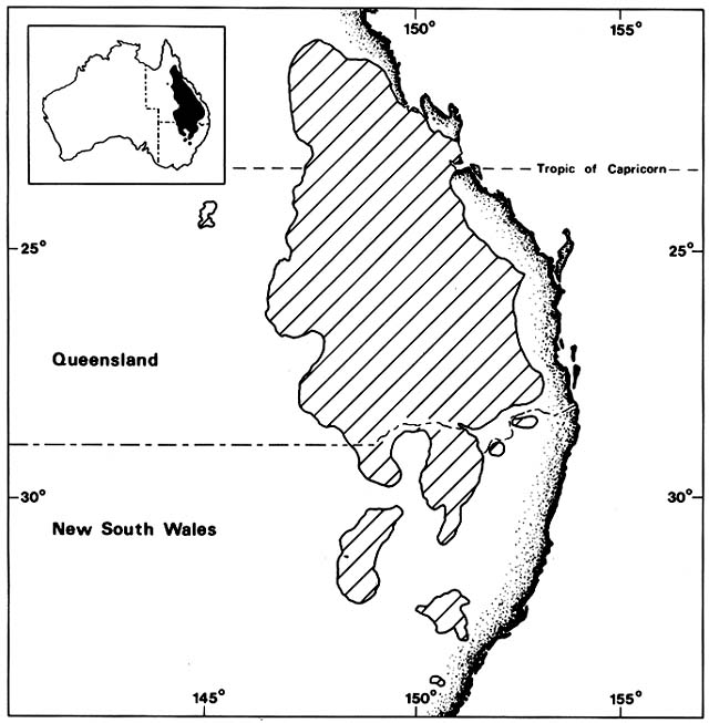
Figure 6. Maximum Range of Two Introduced Cacti (Opuntia stricta and O. inermis ) in Australia. Many plants
have become aggressive invaders when dispersed to regions free from their former parasites and herbivores.
Australia had no cacti until the nineteenth century when various New World species were introduced in cultivation.
Several of these escaped and spread rapidly in spite of control efforts. The map shows the combined ranges of the
two worst pest species in the early 1920s, before they were eliminated by insects introduced from South America.
(Adapted from Mann, 1970)
seashores of the Gulf of Mexico and Caribbean. How and when they reached Australia is unknown, but by the mid-nineteenth century they were being widely planted for hedges by homesteaders in eastern Australia. Both spread on their own on the cattle and sheep ranges and were recognized as a nuisance by the 1880s. Dispersal was partly by vegetative propagation from pads adhering to livestock and partly by seed. The fruits were attractive to feral pigs, emus, and many other mammals and birds.
How successful the cacti would have been if the region had been ungrazed is uncertain. They spread mainly in open savanna woodlands, largely dominated by brigalow, Acacia harpophylla , and Casuarina spp., vegetation types in which grass fires were a normal part of the system. Hotter fires in ungrazed grass would presumably have been harder on the cacti than on the native plants. Although the two Opuntia species did naturalize in some coastal sites similar to their home habitats, their main infestations were inland, on both sides of the Great Dividing Range, up to elevations of about 800 m. The western limit was about 650 km from the coast. At their peak in the early 1920s, the two Opuntias infested about 25 million ha of land between 21° and 33°S latitude (fig. 6). Mechanical removal and chemical control cost more than the value of the land. Many sheep and cattle holdings were abandoned as useless.
In 1924, the Queensland government paid bounties for the slaughter of 335,000 emus and other birds blamed for spread of cactus seeds. The following year it was estimated that the cacti spread at an average rate of 100 ha/hr.
The tide was turned by biological control, an approach pioneered by Australian entomologists. Work had begun in 1912, when the Queensland government sent an expedition abroad to find cactus-feeding insects. They brought back a moth species native to Argentina, Cactoblastis cactorum , which unfortunately did not survive. They also imported cochineal bugs, Dactylopius spp., which were successfully reared, but work was suspended for the duration of World War I. In 1919, the Commonwealth Prickly Pear Board was set up. New expeditions to the Americas collected many kinds of cactus-feeding insects, including about 50 new to science. These were reared in quarantine and screened by starvation tests on economic plants. The first insects to be released were cochineal bugs, Dactylopius opuntiae , native to the southwestern United States. The bugs were successfully established on pest cacti in several Australian localities in 1921–1923; by 1924 patches of the cacti began to die. The government, enthusiastically helped by private initiative, spread the bugs along all the roads in the cactus-infested territory. The effect, however, was somewhat disappointing as cactus mortality was highly variable.
The catastrophic wiping out of the cacti was not accomplished by Dactylopius but by Cactoblastis cactorum . This moth was reimported from Argentina and finally released throughout the cactus-infested territory in 1926–1927. Moth eggs were supplied by the hundreds of millions free of charge
to landholders. The larvae fed on the cactus pads, riddling them with tunnels; most of the cacti promptly collapsed and died. By 1933, 90% of the Queensland cacti were gone. The crash of the cacti was followed by a crash of the insect population; then there was some cactus regeneration and resurgence of the insects. The cycles continued in constantly damping waves. At present, only a few cacti and their obligate parasites survive in scattered colonies, carrying on a stable hide and seek, host—predator relationship.
The story is not over. The tiger pear, Opuntia aurantiaca , native to Argentina and Uruguay, became a relatively minor pest in eastern Australia after 1911. It is currently spreading in east-central New South Wales in spite of large sums spent on attempted control. Cactoblastis larvae feed on the tiger pear, just as they do in their joint homeland, but they are not lethal to the cactus and do not stop its spread.
Comment
Pastoral peoples have commonly introduced domesticated pasture plants, both grasses and legumes, along with their livestock. This kind of comigration of symbiotically associated plants and animals occurred during European colonization of eastern North America and New Zealand, for instance. Since crop migrations are outside the scope of this book, the cases considered here follow other patterns.
Many cases have involved turning domestic animals out to shift for themselves on wild vegetation composed of species they had never met before. When this was done on islands that had previously lacked large herbivores, the effect on vegetation was catastrophic. There are many cases other than those discussed above; three additional examples on uninhabited islands can be cited. Ilha da Trindade in the tropical South Atlantic had forests that were destroyed by goats and pigs liberated by the famous scientist, Edmond Halley, in 1700 (Eyde and Olson 1983). Macauley Island in the Kermadec group in the temperate South Pacific had several dominant forest tree species that were exterminated by goats and pigs liberated in the early nineteenth century (Sykes 1969). Lastly, Rabbit Island, located 3 km off the Australian mainland in Bass Strait, acquired its rabbits in the mid-nineteenth century. The exterminated most of the flora. After the rabbits were in turn exterminated in 1960, plant recolonization from the mainland was rapid. The number of native species in the flora increased from 20 in 1960 to 49 in 1980 (Norman and Harris 1981). The losses of plants in these three cases may be partly attributable to island plants being poorly adapted to cope with herbivory, but they can probably be mainly blamed on uncontrolled growth of animal populations. Feral livestock on islands have commonly been free
from diseases as well as predation. The ultimate control on their populations is starvation.
Recent introduction of domestic herbivores to new continents, specifically Australia and the Americas, has also had catastrophic effects. Ecosystems with rough equilibrium between native plants, herbivores, and predators were replaced with new systems in which the predators were eliminated and grazing pressure increased by orders of magnitude. Although the native floras had coevolved with herbivores, the plants were unprepared for the escalated consumption, and the more palatable species generally retreated from large areas. In southwestern North America, various wild plants that were formerly gathered in quantity for food by the Indians are now extinct over large regions; some survive only where protected from grazing (Bohrer 1978).
The other side of the coin is the advance of plant species that benefit, in one way or another, from increased herbivory. Some of these are native pioneers from nearby riparian, coastal, and other open sites that invade areas formerly closed to them. With overgrazing, opening up of bare ground and reduction of burning are so tightly correlated that it is often hard to sort out their roles in allowing these advances. This question arises in many cases in addition to those cited above, for example, in advances of mesquite (Prosopis spp.) in overgrazed grasslands in southwestern North America (Fisher 1977; Gilbert and Moore 1985) and in Argentina (D'Antoni and Solbrig 1977).
Along with the native pioneers, exotic invaders usually thrive with increased grazing. Occasionally, some species arrive in the coats of the introduced livestock, but usually they arrive later by accidental or deliberate human dispersal. It is commonly assumed that this is because they had to await habitat disturbance, but this is not always proven. In western North America, for example, Bromus spp. and other Eurasian annuals have spread on both overgrazed and undisturbed ranges. These annuals grow so fast and abundantly in the spring that they are only partly consumed by livestock. Unpalatable when mature and dry, they accumulate as dead fuel. Commonly this has resulted in reversal of the advance of fire-sensitive native species after grazing removed the original fire-carrying native grasses. Furthermore, in the Mojave Desert of California, these Eurasian annuals have invaded ungrazed regions dominated by creosote bush, Larrea divaricata , and cacti, Opuntia spp., which were originally fireproof because of sparse herb cover. Repeated burns decimate and may eventually eliminate native shrubs.
Drastic effects of increased herbivory are not confined to islands and continents where herbivores are invaders. The African examples discussed above show that even where plant and animal species have lived together since prehistoric time, recent human-controlled buildup of animal populations has also resulted in local retreats and advances of native species and invasion of exotic, unpalatable species.
Altered Forest, Woodland, And Brushland
Fire Regimes
Conifer and Hardwood Forests, Great Lakes Region
(Curtis 1959; Flader 1983; Heinselman 1981; Loucks 1983)
Finley (1976) and other workers have made magnificent maps of vegetation of the Great Lakes region from the original land survey records preceding white settlement. These showed an intricate forest mosaic with kaleidoscopic associations of dominant tree species. The patterns included a great climatically controlled gradient between boreal conifer forest and temperate deciduous hardwood forest. Other patterns resulted from edaphic variables, largely due to recent glaciation. Superimposed on these were dynamic patterns resulting from natural and artificial disturbance. Windthrow, lightning-set fires, and Indian burning were pervasive factors in the region. Only small parts of it were in the maple—beech—hemlock forest type discussed in Chapter 2, which had gone long enough without disturbance for fire-dependent species to have been eliminated by succession.
Fire can probably be treated more realistically as a partial function of vegetation than as an independent variable. Allowing for some chance variation in ignition and spread due to weather, fire regimes and vegetation may covary as roughly predictable feedback systems.
The original boreal conifer forests were subject to large, intense crown fires in a cycle of roughly 50 to 100 years. Of the dominant conifers, black spruce, Picea mariana , and jack pine, Pinus banksiana , reoccupied burns immediately from seed that survived on killed trees in unburned cones. White spruce, Picea glauca , and balsam fir, Abies balsamea , did not survive on burns but recolonized more slowly from wind-borne seed from outside the fire perimeter. The conifers were often joined on new burns by Populus tremuloides and Betula papyrifera . Both resprouted vigorously after burning and could persist indefinitely on sites where fires recurred often enough to prevent takeover by the longer lived conifers. Dry sandy regions had grassy jack pine barrens kept open by frequent ground fires. The southern margin of the boreal forest had scattered groves of white and red pine, Pinus strobus and P. resinosa . These pioneer pines were incapable of invading undisturbed forest, and the groves may have been initiated by windthrow followed by hot fires. These pines grew taller and lived longer than other trees in the region; mature groves survived recurrent ground fires.
South of the boreal forest was a wide belt of mixed conifer—hardwood forest with very complex, patchy species patterns. All the trees mentioned above ranged down into this zone, with fire regimes similar to those in the north. The importance of these northern species decreased gradually southward,
and they became increasingly restricted to marginal sites, for example, black spruce in swamps and pines on cliffs, while various oaks and other deciduous hardwoods became increasingly dominant. The hardwood forests, even those that had not reached the maple—beech—hemlock stage, commonly were too shady to have much undergrowth, and crown fires were unlikely. Perhaps some occurred during extreme droughts at intervals of centuries.
The transition from hardwood forest to prairie in the southwestern Great Lakes region was a patchy mosaic of forest, oak savanna, and open prairie. The prairies had a rich flora of perennial grasses and dicot herbs, all adapted to frequent, even annual, fires. The parklike oak savannas were generally dominated by burr oaks, Quercus macrocarpa , mostly huge, old fireproof trees. The savannas also contained various species of oaks that were killed back to the ground by grass fires but resprouted repeatedly; these developed massive root systems, locally known as grubs, but had only low, bushy shoot systems.
Throughout the region, fires were commonly set by lightning and by Indians. Most of the Indian groups in the Great Lakes region were hunters, fishers, and gatherers. In the southern part of the region, sedentary agricultural groups opened clearings in the hardwood forests for milpas to produce crops of Mexican origin. The abandoned fields were colonized by white pines and other pioneer trees.
This whole fabric, from boreal forest to prairie, was torn apart and rewoven into a different pattern in less than 100 years. Boom and bust logging moved westward through the region in the late nineteenth century, concentrating on old growth white and red pines. Groves were clear-cut and hardwood forests were scavenged for scattered pines, even if there were only one or two per acre. By itself, this selective logging would have been a brief perturbation with no great effect on the forest in the long run because the pine species were not eliminated. However, the logging was merely the beginning of general deforestation. In part, this was due to accidental conflagrations, commonly started in logging slash. In the drought year of 1871, crown fires starting in slash burned 1.5 million ha of Michigan and Wisconsin forests. Much more forest was deliberately cut and burned by settlers, largely land-hungry immigrants from northern Europe who regarded hardwood forests as indicators of good soil. Many worked part-time as loggers or miners while gradually clearing a farmstead. The region's copper and iron mines also consumed hardwood as charcoal for smelting. Later, there was some commercial cutting of hardwoods for flooring and other lumber. However, by and large, the Great Lakes forests were destroyed through persistent hard work by would-be farmers trying to execute a national policy: the plow follows the axe.
By the 1920s and 1930s, it became obvious that much of this region, now known as the Cutover, was submarginal for agriculture. Farm abandonment and population exodus began. By then, seed sources for most of the
conifers and nonsprouting hardwoods had been so reduced that direct recovery of former species distributions was impossible. Huge expanses of country became blanketed with nearly pure stands of scrubby aspen and birch, persistent sprouters with wind-borne seed.
Pulpwood exploitation of the boreal forest conifers had begun in the region about 1900. As the stands of these trees were depleted, the paper companies switched to aspen and birch. Formerly considered useless weed trees, these are now a major resource of the region, with stands deliberately maintained by clear-cutting on a short rotation. Aspen and birch, formerly minor pioneers, now dominate far more of the Great Lakes forests than any other species.
Where the Cutover is not being exploited for pulpwood, fire suppression is permitting gradual spread of later successional trees. However, this does not mean that forests are returning to their former patterns. Modern fire suppression programs have been so effective that most of the Great Lakes forests can now be expected to die of old age before experiencing a fire. As compared with presettlement fire regimes of burns every 50 to 300 years, the current fire rotations are mostly in thousands of years. If maintained, only a few extremely shade-tolerant species will reproduce and survive.
South of the Cutover, in the regions formerly in a mosaic of hardwood forest, savanna, and prairie, permanent agriculture and pasture were successfully established in the nineteenth century. Even before they were plowed, the prairies and oak savannas were generally converted to pasture for livestock. Burning was promptly stopped. The consequences for the patterns of species distribution would have been profound, but the point is moot because invention of the moldboard plow in the mid-nineteenth century made it possible to completely destroy prairie vegetation and open up the rich black earth beneath for crops. Like the bison, prairie plant species survive only in a few protected reserves. There are a few exceptions; some prairie species of low palatibility, such as Solidago rigida and Artemisia caudata , survive on farms on pastured slopes too steep and dry to plow. They grow mixed with immigrant Eurasian species, such as Poa pratensis and Taraxacum officinale . In the oak savannas, with end of burning, oak grubs and seedlings rapidly grew up to young forests. Remnants of these and of the older hardwood forests of the region that have not been cleared are now generally used as farm woodlots; they also serve as shady refuges for cattle in the summer. Browsing eliminates tree seedlings, and trampling changes the herb layer composition, with Plantago major and other Eurasian weeds now common.
Conifer Forests and Woodlands, Western United States
(Arno 1980; Gibbens and Heady 1964; Habeck 1976; Harvey et al. 1980; Houston 1973; Johannessen et al. 1971; Kilgore 1981; Kilgore and Taylor
1979; Lockmann 1981; Lunan and Habeck 1973; McBride and Jacobs 1980; Minnich 1977, in press; Rundel 1972; Vankat 1977; Zedler 1977)
For millennia, uncontrolled wildfires were a normal part of the coniferous forest ecosystems of western North America. The spatial pattern of species and the pattern of burning were interrelated in a feedback system, each being partly dependent on the other. Different kinds of conifer stands tended to generate and be a consequence of different fire regimes. For example, at higher elevations in the Rocky Mountains, dense Picea engelmannii forests were typically fire free for about a century in spite of occasional lightning strikes before the inevitable crown fire during extreme drought. On north slopes, spruce seedlings would generally reoccupy the burn at once; on south slopes, there was often a simple succession, with Populus tremuloides and other pioneer trees dominating the site for about 50 years before the spruce regained dominance.
Douglas fir, Pseudotsuga menziesii , had varying fire regimes in different parts of its range. In the normally humid maritime climate of the Pacific Northwest, Douglas fir typically grew in huge, approximately even-aged stands initiated by catastrophic crown fires. A Douglas fir can live for over 1,000 years, but most stands in the Northwest burned within 500 years, probably after rare lightning strikes during abnormal summer droughts. Dominance of the species was maintained by these fires that had long return intervals and replaced entire stands. Otherwise the species would have eventually been displaced by more shade-tolerant conifers, for example, red cedar, Thuja plicata ; hemlock, Tsuga heterophylla ; and grand fir, Abies grandis . In the drier interior east of the Cascades and in the Rockies, Douglas fir commonly grew in an open grassy park landscape, where small surface fires set by lightning were very frequent. Occasionally a stand was fire free for 30 years or more, long enough for reproduction to build up a dense stand of saplings vulnerable to crown fire.
At slightly lower elevations than Douglas fir, Pinus ponderosa also grew in open grassy park landcapes over huge areas of the interior. Most of the old trees but few seedlings survived frequent fires; some old ponderosa pines survived repeated lightning strikes that ignited grass beneath them. The Sierra bigtree, Sequoiadendron gigantea , grew in scattered groves surrounded by a sea of other conifers. Mature and old trees invariably have scars of repeated fires on their trunks; the fires burned under the trees without crowning. Sequoiadendron cones open when heated by fire, releasing seeds that find optimum conditions for establishment on a fresh burn.
These generalizations about fire regimes are, of course, oversimplified. Fire frequencies and intensities were highly variable from time to time and place to place within a given type of forest. Vagaries of firekill and postfire recolonization produced a dynamic patchwork of stands differing in age
structure and species composition. The scale of the patches varied with topography, tending to be finer in more rugged terrain.
Incursions of sheepherders, ranchers, and loggers and disruption of the Indian populations undoubtedly had some effects on fire regimes, but it is unclear what those effects were. Later on, as settlement proceeded and concern about uncontrolled fires grew, it became customary to blame human ignitions by Indians, sheepherders, or whomever for catastrophic destruction for forests. Few people recognized that wildland fires might be natural and inevitable. In southern California, for example, it was widely believed that fires caused by humans had destroyed formerly continuous stands of conifer forests, leaving only degraded chaparral. Widely scattered groves of bigcone spruce, Pseudotsuga macrocarpa , obviously scarred and damaged by fire, were taken to be relics of former great forests, although the species was probably always confined to little habitat islands in a sea of chaparral. It is the only conifer in the region that can survive having its crown scorched and defoliated.
During the early part of the twentieth century, fighting forest fires became a moral crusade, and during the 1920s and 1930s enough technology and manpower was thrown into the fight that suppression became extremely effective. Foresters eventually realized, however, that they had grabbed a tiger by the tail. The longer the fire was postponed, the denser the forest became, the more fuel accumulated, and the harder fire was to control. When one finally got away, usually under the worst possible fire weather conditions, the larger and hotter the burn. By the time policy shifted from indiscriminate fire suppression to controlled burning, it had become extremely difficult to make headway against the huge areas of aging forests with heavy fuel loads. As a temporary expedient, most fires in western forests are still being suppressed.
Fire suppression has had very uneven effects on distributions of different species. Effects have probably been least in very high elevation forests of Pinus contorta and Abies lasiocarpa and other subalpine species, where fire suppression generally began only about 50 years ago, recovery from past long-interval crown fires is slow, and the mosaic pattern of different-aged stands still persists. Changes have been most marked at the other extreme, namely, in lower elevation ponderosa pine woodlands and savannas. There, the end of ignition by Indians and the onset of livestock grazing may have ended burning long before effective government intervention in fire suppression. Also, grazing favors pine reproduction by reducing competition with pine seedlings by the grass. As a result, former pine woodlands and savannas now commonly have a dense understory of young pines. Toward their upper limits, some formerly pure ponderosa pine stands are being invaded by Douglas fir.
In the Sierra Nevada, Sequoiadendron groves that were kept open by
surface fires have been strongly invaded by young white fir, Abies concolor , not only preventing bigtree reproduction but threatening the old trees with immolation.
Conifers also invaded areas formerly dominated by oaks. In Oregon's Willamette Valley, extensive park savannas with scattered Quercus garryana and Q. kelloggii have been invaded by dense stands of young Douglas fir. The namesake of the tree, David Douglas, recorded Indian burning of these savannas in 1826. Similarly, when Indian fires were stopped in Yosemite Valley, meadows with scattered Q. kelloggii trees were soon invaded by dense stands of ponderosa pine and other conifers. Overgrazing of the meadows by livestock probably accelerated this invasion, but it continues today even where meadows are not grazed; the National Park Service currently uses frequent prescribed burning to prevent conversion of the meadows to conifer forest.
The other side of the coin has been retreat of pioneer species. In several national parks in the Rockies, Populus tremuloides groves are senile and dying out. They were formerly regenerated by hot fires and had a headstart on conifers by root sprouting, but in the absence of fire, the clones have a short life. In Sierra Nevada bigtree groves, shade-intolerant shrubs, such as bitter cherry, Prunus emarginata , snowbush, Ceanothus cordulatus , and manzanita, Arctostaphylos patula , have died out under dense canopies of young Abies concolor . Fire suppression has not lasted long enough to cause retreat of fire-dependent conifer species. Although their reproduction has been suspended, most are so tall and long-lived that loss of territory by successional replacement would require centuries. it is now recognized that postponement of fires that long is unlikely.
A more immediate concern is possible conifer mortality due to abnormal fuel accumulation. Replacement of a mosaic of largely immature stands by a homogenized blanket of aging forests or brush may make formerly tolerable fire so intense as to be lethal. The most vulnerable species would be those with poor seed dispersal that depend on survival of old trees for subsequent reproduction. It is ironic that Pseudotsuga macrocarpa , which fire suppression was expected to restore to former imaginary abundance, may have lost ground because of fire suppression. Minnich (1977, in press) has evidence from sequential aerial photography and ground study that P. macrocarpa groves that recovered from earlier, smaller fires have been wiped out by hotter fires.
A quite different road to extinction may be traveled by Tecate cypress, Cupressus forbesii . As with Pseudotsuga macrocarpa , its natural pattern consists of small groves scattered throughout a sea of southern California chaparral. Unlike bigcone spruce, however, Tecate cypress trees are killed by fire but recolonize the burns with seed stored in closed cones until scorched. However, the trees do not produce any cones until they are about 10 years old.
Zedler (1977) believes that the natural return interval of fire in the Tecate cypress habitat is more than 40 years. Recently, human set fires have burned some of the groves repeatedly at much shorter intervals than that; some groves are unlikely to survive continued unnaturally frequent fire.
Retreat of Proteaceae, South Africa
(Vogts, 1982)
In the Cape of Good Hope region, the native sclerophyll scrub or fynbos had a rich endemic flora including many Proteaceae. The shrub species characteristically were strong colonizers of burns, seed being released from dormancy by the fires. Originally, the brush probably burned at intervals of a decade or a few decades, long enough for an accumulation of stored seed but within the life span of the shrubs. Presumably, vagaries of fire patterns caused some micromigrations, but species patterns were in rough equilibrium.
In the early colonial period, European settlers commonly increased the frequency of burning so greatly that the fynbos species lost much ground to grasses and other herbaceous vegetation. More recently, efforts to conserve remnants of the fynbos have involved fire suppression. Often fire frequency was pushed to the other extreme, being delayed beyond the normal life span of the shrubs, which thus lost more ground. For example, the spectacularly beautiful blushing bride (Serruria florida ) had declined to a single population in the Franschhoek Mountains. When in 1930 the number of plants declined, the cause was attributed to frequent fires and the area was rigidly protected. In 1962, not a single plant could be found in the protected area and only a few outside it. The species appeared to be about to become extinct in nature, although it was being cultivated in gardens. Then, an accidental fire swept the protected area, and seed stored underground germinated and new plants were established. The so-called marsh rose (Orothamnus zeyheri ) also became nearly extinct until discovery that reproduction of the few surviving plants was favored by burning.
The South African ecologists are studying proper fire intervals to encourage regeneration of different species of Proteaceae. Not only individual Proteaceae species but whole communities are adversely affected by the total absence of burning. In the Marloth Reserve at Swellendam, an area dominated by Proteaceae was fenced off and protected from fire and alien vegetation for 50 years. By then, Proteaceae were becoming senile and the area was being taken over by other fynbos species.
Eucalyptus Forest Dieback, Western Australia
(Shea 1979, 1982)
More than 1.5 million ha of lateritic uplands in southwestern Australia originally had a tall forest of jarrah, Eucalyptus marginata . The forest was rather open, with Acacia spp. dominating the understory, and was subject to occasional medium-intensity fires that did not kill the jarrah. Since early in the nineteenth century, jarrah forests have been logged for their fine timber. Fire was uncontrolled until World War I, when a policy of complete fire suppression was begun. After 35 years of suppression, it was decided that the policy was a failure because the forest was adapted to fire. For the next 25 years, prescribed low-intensity burning of the whole jarrah area was instituted on a 5- to 7-year cycle. This tended to eliminate the Acacia understory, which needs hotter fires to stimulate seed germination. The understory became dominated by Banksia spp., formerly minor components.
Jarrah dieback began in small areas soon after 1900, expanding slowly until the 1950s, when it accelerated. In 1966, the cause of the disease was finally identified as Phytophthora cinnamomi , a saprophytic soil fungus and root parasite. The fungus is believed to be native to southeastern Asia, Indonesia, and Queensland, but it is common in much of the world on many host plants. Why it did not reach Western Australia and attack the jarrah earlier is a puzzle. Possibly it had to wait for logging and disruption of the original fire regime. There is evidence that the fungus is spread by logging trucks. Also, the replacement of Acacia by Banksia in the understory evidently favored the fungus. Acacias are not susceptible to Phytophthora and emit soluble compounds that suppress it. Banksias are highly susceptible, their roots acting as pathways for spread of the fungus. Death of banksias and jarrahs raises soil temperature and favors fungal infection. In patches of the forest, all jarrahs of all ages have died, but mortality varies greatly with local edaphic conditions. Whether the dieback can be controlled by changes in fire regime remains to be seen.
Comment
Prehistoric human effects on forest fire regimes are outside the scope of this section. Also excluded are historical cases where native forests have been replaced by forestry nurseries and tree plantations. In the cases dealt with here, recent human intervention in fire regimes has had relatively subtle effects on tree species distributions.
Artificially increased frequency of burning, if continued longer, might
eventually cause more drastic retreat and even extinction of species too slow to mature and reproduce, like the Tecate cypress.
In the United States, the policy of complete forest fire suppression ran its course in far too short a time to eliminate most fire-dependent tree species. It would probably have been impossible to postpone fires beyond the life span of the tall fire-dependent conifers. In some places, fire has been postponed long enough to convert the former mosaic of different-aged forest patches to a homogeneous blanket of old growth where any wildfire would be extremely intense. It is not clear how much effect this would have on species distributions. Fire suppression has caused local retreats of some short-lived pioneer trees, such as the trembling aspen, but these species also have populations in other kinds of habitats, and there is no threat of their becoming regionally extinct.
The vagaries of natural fire regimes were evidently such that trees did not become rigidly adapted to a precise timetable. Moreover, many individual species have such broad ranges and occupy such diverse sites within those ranges that they had to have flexibility in surviving and exploiting fires.
Some South African fynbos endemic shrubs were so restricted geographically that extinctions by changes in fire regimes are conceivable. However, the gradual disappearance of species observed in old brush when fire is artificially excluded does not prove they are becoming extinct. Perhaps they can survive on unburned sites for long intervals as dormant seed.
Altered River Flood Regimes
High Plains, North Dakota and Nebraska
(Johnson et al. 1976; Williams 1978)
In North Dakota, the formerly wild Missouri River has been converted to a series of reservoirs and stabilized channels with controlled flow. Dam construction, primarily for flood control downstream, was completed mainly in the 1950s and 1960s. The extensive floodplain formerly had a dynamic pattern of deciduous hardwood forests. During the great spring floods with snowmelt in the Rocky Mountains, the meandering channel swept away patches of established forest and deposited fresh alluvium to be colonized by pioneer trees. The first of these were seedling willows and cottonwoods, particularly Salix amygdaloides and Populus deltoides . If these were left undisturbed by the river in later years, they were invaded by ash, Fraxinus lanceolata ; box elder, Acer negundo ; elm, Ulmus americana ; and finally, burr oak,
Quercus macrocarpa . Since damming, river meandering has all but ceased and no young willows or cottonwoods are establishing. Flooding has been eliminated on areas more than 2 m above mean river level, thus decreasing moisture and nutrients on most of the former floodplain. Elm and box elder reproduction are declining, and there has been a significant decrease in growth rates of all the floodplain forests. It is expected that in the future, all the species will retreat to fragmented remnants of their former distributions.
Change in riparian vegetation has been quite different along the Platte River system in western and central Nebraska. Explorers and travelers in the 1800s reported that islands in the river were heavily wooded with willows and cottonwoods but that the riverbanks had hardly any trees, perhaps because of prairie fires. At that time, the river flooded wildly in spring and was commonly completely dry in late summer. Dam construction began in 1970, primarily for irrigation rather than downstream flood control. Comparisons of channels in 1865 and 1969 over a 480 km reach show a reduction in channel width by 90% in the upper reaches and 30% in the lower reaches. Peak discharges and annual discharges have been greatly reduced, but return seepage from irrigation keeps the river flowing through the summer in the lower reaches. Time-lapse photographs show a huge increase in vegetation in the former channels and along the banks. Sandbars in former channels were colonized by sedges and grasses, followed by willow, cottonwood, elm, ash, box elder, and hackberry, Celtis occidentalis .
Similar dramatic time-lapse changes below dams have been recorded on several other High Plains rivers (Williams and Wolman 1984).
Dammed Rivers, Arizona
(Graf 1982; Turner and Karpiscak 1980)
Before Glen Canyon Dam was completed in 1963, the discharge and water level of the Colorado River running through the Grand Canyon varied vastly from season to season and year to year. Since the dam was built, these variations have been almost eliminated in normal years; discharge has varied mainly on a daily cycle with demand for electrical power from the generators.
Predam vegetation was recorded by a long series of river-running expeditions; starting in 1871, excellent photographs were taken. Ten years after Glen Canyon Dam was built, the National Park Service began rephotographing the riparian vegetation from the same camera stations as the old pictures. These matched pairs show two different effects of the dam on plant distribution.
First, species that were locally present above the former floodline have colonized the zone below the line that was formerly scoured clean of plants.
For example, Acacia greggii, Prosopis glandulosa , and Brickellia longifolia , which grow on stabilized talus and sand above the former floodline, now have abundant seedlings below it. These are not strictly riparian species.
Second, a different pattern of migration has been the spread of truly riparian species along the new daily high waterline into reaches where they were previously unable to withstand the scouring action of floods. Some of these are natives of the general region, for example, cattails, Typha latifolia and T. dominguensis ; common reed, Phragmites australis ; willows, Salix exigua and S. goodingii ; cottonwood, Populus fremontii ; arrowweed, Pluchea sericea ; and seep willows, Baccharis glutinosa and B. emoryi . Seeds of all these may have blown and floated along the main river; some probably also invaded from tributary canyons. The cottonwood, for example, was present before the dam only in tributary canyons in the Grand Canyon region.
Three recently introduced Eurasian shrubs also spread along the new waterline: camelthorn, Alhagi camelorum ; Russian olive, Eleagnus angustifolia ; and tamarisk or salt cedar, Tamarix spp. Invasion by tamarisk of natural riparian habitats in the southwestern United States was discussed in Chapter 1. Tamarisk was present along much of the Colorado River, including the Grand Canyon, by the 1930s, but only in widely scattered sites. The Glen Canyon Dam allowed spectacular expansion of Tamarisks as a dense, almost continuous fringe along the daily high water mark.
After 20 years under control, in June 1983 the Colorado River, fed by phenomenal snowmelt, overwhelmed the storage capacity of Lake Powell behind Glen Canyon Dam. The Bureau of Reclamation opened the spillways on the dam. By June 25, 1983, the river was destroying vegetation and removing beaches up to the predam floodline. The effects await restudy.
Tamarisk has also benefited from controlled flow below dams on other Arizona rivers. Before the 1920s, the middle Gila River and its tributary, the Salt River, were perennial streams. Their banks were lined with willows and cottonwoods, and the sand bars temporarily colonized by seep willows and arrowweeds. After dam construction, water was diverted for irrigation rather than stored for power generation, and surface water flows below the dams were reduced to rare floods. Much of the former channel was occupied by tamarisk, forming dense and extensive thickets. Tamarisk was mapped over a 100-km reach of the river from aerial photographs taken at seven different times between 1937 and 1979. These show that the main spread was completed by the early 1940s; since then, there have been great fluctuations in the tamarisk populations. Some have died out during periods when the channel had a very low groundwater table; others have been ripped out in the rare floods, but colonization has been rapidly resumed.
Tamarisk has also benefited throughout the Southwest from sedimentation behind dams; it forms dense jungles on delta deposits at the heads of reservoirs.
Mississippi River Deltaic Plain
(Baumann et al. 1984; Becker 1981; Coleman 1966; Coleman and Gagliano 1964; Russell 1967)
Prior to construction of artificial levees, the Mississippi River behaved much like the uncontrolled Mexican rivers discussed in Chapter 1. Since the postglacial eustatic rise of the sea approached the present level about 5,000 years ago, the main river channel has wandered back and forth across the great deltaic floodplain over an east to west span of more than 250 km. During this time, the river built six different deltas, each containing several subdeltas where an active distributary was located for about a century. The total land area did not increase greatly during this time because, while sediment deposited during floods was building new natural levees and marshes at active river mouths, subsidence and coastal erosion caused loss of land in the rest of the region. This is because continued loading of sediment causes crustal downwarping and compaction of the thick, ancient sediments under the whole plain. Local plant colonization followed advancing natural levees, beach ridges, and freshwater marsh development. Cores from deep borings through sediment sequences show that when a distributary was abandoned and input of fresh river sediment was shut off, formation of organic peat by marsh plants sometimes kept pace with subsidence for a while, but eventually large open water bays developed. Wave erosion along their shorelines caused rapid retreat of plant species until the next cycle of deposition began.
Since the foundation of the city of New Orleans on the current main river channel, artificial levee construction has brought the river under increasing control; by 1920, it was considered to have been tamed. A phenomenal flood in 1927 led to even more massive engineering, and the river was walled in by great mainstream levees along its entire length. The one major opening above New Orleans has been the Atchafalaya River, which branches off the main river 80 km above Baton Rouge. The Atchafalaya has taken an increasing part of the Mississippi discharge every decade since 1860. By now it would have become the main mouth of the Mississippi if the U.S. Army Corps of Engineers had not restrained the diversion. They currently allow a maximum of 30% of Mississippi floodwater to be captured by the Atchafalaya. This supplies fresh sediment to the marshes and swamps of the great Atchafalaya basin, and a new subdelta is being built into the Gulf at the river mouth. The new mudflats are being colonized by Salicornia, Spartina , and other salt marsh plants. Eventually, the subdelta should build out about 50 km onto the shallow continental shelf and provide extensive new habitat for freshwater marshes and cypress swamps.
However, this local accretion of new land is not offsetting losses elsewhere.
Levee construction has kept the main flow of the river down the same old channel past New Orleans for so long that the active subdelta was extended out to the edge of the continental shelf. Every year since then, hundreds of millions of tons of alluvium have been wasted by being dumped into deep water instead of building new land. This weight still causes crustal downwarping and regional subsidence accompanied by expansion of open water and shoreline erosion. Loss of sinking marshland has been accelerated by digging of canals for navigation and oil exploration; these have helped expose marshes to severe damage during hurricane passages.
By 1960, net losses of Louisiana wetlands to open water were estimated at over 40 km2 /year and by 1980 at about 130 km2 /year; losses are accelerating. Bald cypress, Taxodium distichum , and freshwater marsh plants are the major losers. Salt marsh species have shifted landward. Also, beach plants often persist along a retreating coast, riding on sandy beach ridges that are pushed landward by the advancing sea.
Comment
Artificial levees on the Mississippi River deltaic plain have had profound and complex effects on the plant geography of the region. By contrast, case histories of dam building show rather simple, predictable effects on riparian plant patterns. Elimination of floods and evening out of flow through the year narrow the zone in which riparian species can live and at the same time make this narrow zone more continuous. However, if the dams are incompetent to handle great floods, the continuity may be only temporary, and there may be episodes of decimation and recolonization along the riverbanks that are longer in time scale than in the original, natural regimes.
The available case histories do not suggest that engineering works have been responsible for changes in gross species ranges. Rather, there has been local repatterning of species that were present in natural habitats within the region.
5
Discussion Of Modern
And Historical
Migrations
In the abstract model presented in the Introduction, geographic patterning of seed plant species is the product of interplay between opposing forces tending to expand or restrict the distribution. The main centrifugal force is usually seed dispersal; the main centripetal force is environmental selection. When dispersal and environment are sufficiently stable, fluctuating within normal limits, these forces eventually equilibrate and the species borders become static. Migration, whether advance or retreat, occurs when equilibrium is upset by changes in dispersal or environment or both. The case histories that have been discussed thus far show a variety of migration patterns resulting from such changes.
Changes In Dispersal
Changes in dispersal alone, with no change in environmental selection, can result in both local and long-range colonization. An example of local colonization is the arrival on Baltic islets of new plant species after a change in the foraging grounds of gulls nesting on the islets. An example of long-range colonization is the introduction from overseas of ruderal plants with wool imported to France. New colonies produced by such long-range dispersal are commonly ephemeral and nonreproductive. However, there are also a great
many cases of successful establishment of widely disjunct populations following long-range dispersal. Most of these are weeds of artificially disturbed habitats or wild pioneers of seashores, streambanks, and other naturally disturbed habitats, but there are also cases of introduced exotic plants invading undisturbed native vegetation, both on remote islands and on continents.
As would be expected, recent establishment of new, widely disjunct colonies is mainly due to human introduction, the major new agency of long-range dispersal. Only occasionally are new colonies attributed to natural long-range dispersal, for example, the arrival of an orchid, Spiranthes romanzoffianum , in the British Isles in the nineteenth century by wind-borne seed from North America. For two reasons, however, formation of disjunct colonies by natural long-range dispersal may be going on without being recognized. First, the mode of dispersal may be unrecognized. For example, if plant species were to arrive in Hawaii by ocean, wind, or bird dispersal in the present day, as they undoubtedly did many times prehistorically, they would inevitably be assumed to have been artificially introduced. Second, the recency of the colonization may be unrecognized. For example, Madroño: A West American Journal of Botany regularly has a section reporting new collections that extend the known ranges of native plant species. Some of these involve disjunctions of only a few tens of kilometers, but many report populations several hundred kilometers outside the formerly known ranges. These are normally assumed to have been simply newly discovered rather than newly established.
None of the case histories showed retreats of species due to decreased dispersal. Conceivably, extinction of animal species could have caused contraction of seed shadows of plant species, followed eventually by dying out of marginal colonies outside the reproductive core of the plant species. Perhaps this occurred with oaks and other trees that provided mast for the North American passenger pigeon or with aquatic plants with seeds carried in the fur of the European beaver, but no examples are known. A more extreme case, in which the whole population of a plant species may have ceased to reproduce after extinction of an animal, involves two species endemic to Mauritius. The dodo, a giant, flightless relative of the pigeon, became extinct about 1680, soon after the island was colonized by the Dutch. Temple (1977) suggested that a tree species, Calvaria major , was totally dependent on the dodo for reproduction. Calveria was originally common on the island and was cut for lumber in the early colonial period but is now nearly extinct. Only 13 trees survive, all believed to be over 300 years old. Temple fed some of the thick-shelled Calvaria seeds to domestic turkeys as stand-ins for dodos; the seeds germinated after passing through a turkey gizzard.
Changes In Environment
In a great many cases, especially but not exclusively local migrations, advances and retreats are evidently due to changes in the environment, while any dispersal changes appear irrelevant. A change in a single factor in the plant environment, such as introduction of a new herbivore, a new disease, or a new fire regime, commonly causes retreats of some species and advances of others. Such linked migrations are not necessarily on the same scale; the catastrophic retreat of elms in North America was accompanied only by micromigration of the species that replaced them. Sunflowers marched across the continent along roadways that had pushed previous plant occupants back only a few feet.
Disjunctions in species ranges can result from environmental change both by colonization of isolated new habitats and by fragmentation of formerly continuous distributions. Examples of the former include new islands emerging within the reach of sea-dispersed beach plants and artificial marshes formed under the flyways of migratory waterfowl. Many plant distributions have been fragmented by clearing and grazing. Dramatic recent changes in plant environments, like changes in dispersal, have been largely but not exclusively due to human activities.
Changes In Both Dispersal And Environment
Some cases of plant migration involve interconnected changes in dispersal and environment. For example, herds of sheep driven into the Great Basin of western North America evidently carried in their wool seeds of Eurasian grasses that invaded ranges overgrazed by the sheep. On Krakatau, the establishment of figs and other trees dispersed by birds and fruit bats evidently attracted more of those animals to the island and started a positive feedback between forest development and animal introduction of more tree species.