Stormy Flood Period:
1884–1891
Unlike the floods of 1862, those beginning in 1884 could have been predicted in many areas, though with less certainty in California than in other parts of the world. It now seems clear, as previously indicated, that weather changes following the eruption of Krakatoa were the principal cause.
This second extremely wet period began in 1884 and lasted, with intermittent dry years, until 1891 (Kuhn and Shepard 1981). The events of the period are documented in memoirs, letters, and newspapers of the day. The weather was characterized by tremendous downpours; the highest daily, monthly, and annual rainfall levels of record in San Diego County were established during this period. The winters of 1884, 1886, 1889, 1890, and 1891 saw severe cyclonic sea storms, which are unusual for southern California. The intensive rainfall
caused sediment saturation of the bluffs along the coast, and large storm swells and high tides coincided with river basin flooding.
In 1884 there were two separate floods. The first was in February, when the railroad line to San Bernardino was washed out, and for nine months San Diego was cut off from San Bernardino. Several miles of track and all but one bridge between Encinitas and San Diego were washed out, and it was nearly two months before the rail connection between Encinitas and San Diego was reestablished.
Food supplies ran out in Encinitas so a ship was dispatched from San Diego with ten tons of provisions for the stranded settlers. But the heavy rain continued falling, and the waves were breaking far out in the kelp beds or even farther away, so the vessel stayed offshore for over a week, waiting for a chance to unload its supplies. A gale then approached from the southeast, and the ship ran for the lee of Santa Catalina Island. After remaining there for another week, the vessel returned to San Diego, its cargo still undelivered.
The California Southern Railroad station, located directly to the north of Oceanside, near the Santa Margarita Ranch house, reported on 14 February 1884, that in fourteen days rainfall totaling thirteen inches had fallen. This was more rain than had fallen at the same location during the entire previous year. Severe storms were reported throughout San Diego County. The mountainous region to the east was affected by the storms, as reported by the San Diego Union (26 February 1884) following one cloudburst on the southwest slope of Palomar Mountain:
Cloud Burst on Smith's Mountain—A private letter from Agua Tibia near Pala, dated on the 19th, says: "We had the most awful storm Sunday and Sunday night, I ever saw or heard. None of us slept that night. It was frightful. About half past four on Sunday afternoon a terrifying crashing and roaring was heard, and standing in the door we saw a wall of water, seventy feet high, coming down the creek, tearing trees, huge boulders, etc. to pieces, roaring and boiling in its course. It was a
frightful sight. Everything was swept before it. Enough wood was crushed up by this torrent to give us firewood for years. The once thickly wooded glen is swept bare as a sandy beach on the ocean shore. Every tree, shrub and branch is gone. It is absolutely desolate. Surely great destruction must have been wrought along all water courses in the county."
As of 1 April 1884, the California Southern Railroad, which had begun operations between San Diego and San Bernardino only a year earlier, declared bankruptcy on account of the storms and the flooding. By the second week of June, the city of San Diego had measured twenty-five inches of rain, and fifty to eighty inches had fallen in other parts of San Diego County, but the rains began to lessen. By July 1, the rainy season was over.
Between 1889 and 1891, southern California was again battered by violent subtropical storms and exceptionally heavy rainfall. During this period the U. S. Coast and Geodetic Survey (USCGS) was conducting topographic and bathymetric surveys along the coast of San Diego County. The USCGS (1889a ) topographic notes indicate that the bluffs show "new erosion during each winter storm as the characteristic feature of this coast." One thunderstorm hit Encinitas on the evening of 12 October 1889 (U. S. Signal Service 1889), and in eight hours 7.58 inches of rain fell there, while only 0.44 of an inch was measured at San Diego, and 0.04 of an inch at Los Angeles on the same date.
Examination of the 1889–90 San Diego County Tax Assessor records of land parcels located at the mouth of Cottonwood Creek, Encinitas, and south of there (fig. 8a ) indicate that seaward property was greatly devalued or stricken from the tax roles, and land parcels directly inland increased temporarily in value (fig. 8b ). The weather varied greatly from month to month throughout the world during the winter of 1889–90. A stormy condition seems to have prevailed generally throughout much of the United States. During February 1891, there were destructive floods in California, Arizona, and on all major rivers east of the Rockies. Extremely large snowpacks existed in southern California prior to the warm rain that fell from 17–27 February 1891. Pourade (1964:224) noted:
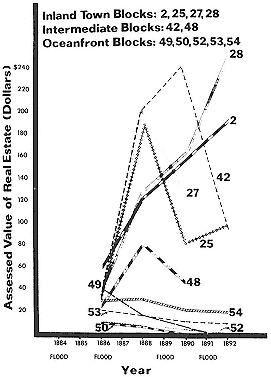
Figure 8a
The assessed value of the former oceanfront and
inland subdivided blocks of Encinitas in the 1880s.
As former seaward parcels of land were devalued,
the blocks directly inland temporarily increased in value.
From San Diego County Tax Assessor
Records, 1886–1892.
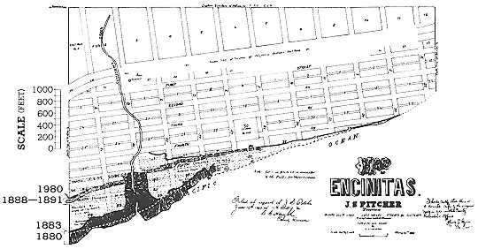
Figure 8b
Subdivision map of Encinitas, 1883. Seaward hachured data are from California Southern Railroad
Topographic Survey, 1880. The white dashed line is from the 1883 subdivision map and the California
Southern Railroad right-of-way location map (January 1, 1883). The 1888–1891 lines derive from the
U. S. Coast and Geodetic Survey, and solid black line farther inland represents the approximate 1980
bluff top. Note that more than 600 feet of retreat occurred between 1883 and 1891.
For its brief duration, scarcely more than a week, the storm that struck Southern California and Arizona in February of 1891 was probably the worst on record. . . .
The San Diego River quickly rose to flood level and hundreds of residents flocked to ride the cable cars to the pavilion park overlooking Mission Valley. A solid sheet of water spread across the valley floor and over the tide flat to False Bay [Mission Bay]. Every telephone and telegraph line was out, railroad connections were severed and a heavy storm at sea with gale winds interrupted shipping. Virtually everything that had been built in the riverbeds or on the alluvial plains between the great watersheds and the sea was gone or reduced to wreckage [presumably referring to much of the coast of southern California]. . . .
Bear Valley [south of Escondido near the present Wild Animal Park] reported thirty inches of rain in thirty-seven hours; Cuyamaca, eighteen inches in forty-eight hours, the City [of San Diego] recorded only 2.57 inches for the storm and 4.77 inches for the month.
As these storms moved east, Arizona was devastated. Flooding in Arizona reached a peak in the last week of February 1891, and the U. S. Army reported that the Colorado River was twenty miles wide at the former crossing at Yuma.
August 1891 was the warmest August recorded up until that time along the Pacific coast (U. S. Signal Service 1891:188, 191). Although no rainfall was reported over the greater part of California, a world record rainfall was verified at Campo (near the Mexican border) on 12 August 1891 when 11.5 inches fell in only eighty minutes!
Perhaps the significance of these floods, as far as coastal erosion is concerned, is that the rains that produced them were very concentrated. In more recent times such rains have caused immediate erosion of sea cliffs. One can imagine how this much more concentrated rainfall would have cut deeply into the cliffs and canyons and would have been responsible for landslides of far greater devastation than those we have experienced in recent years.
When stormy seas and heavy rain of this magnitude attack the sea cliffs, erosion can be so disastrous that any buildings on top of the bluffs, so common now, can be seriously damaged if not destroyed. The one foreseeable alternative to this scenario is that the rivers, swollen by the floods, might carry such a large quantity of sediment to the sea that wide beaches would be formed which would, for a time, protect the cliffs from the waves.