Territoriality and Redistribution of Land Rights
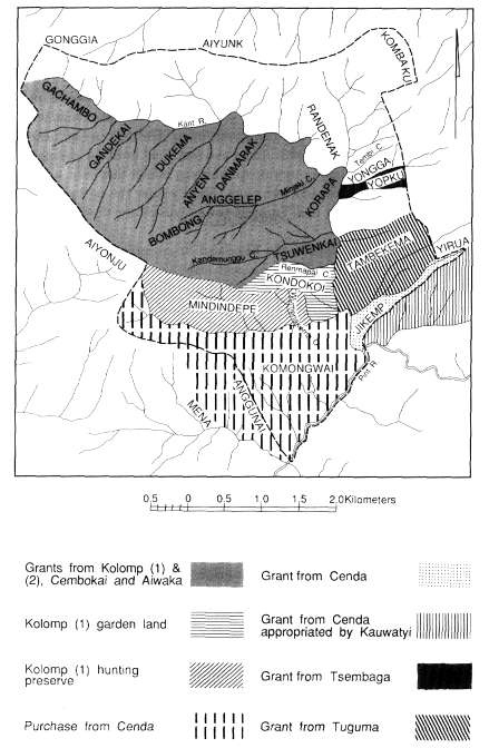
The present boundaries of Tsuwenkai territory (map 3) encompass an area appreciably larger than the earliest known territory held by the Wendekai-Amankai-Afikai cognatic cluster and the original Kolomp settlers. Wendekai, Amankai, and Atikai clans jointly owned the land stretching from the Simbai River at Kinimbong over the Bismarck crest to the Kant River. In the Kant Valley this territory was bounded in the west by the Gacambo saddle and in the east by Tembi Creek. All land southward from here west of the Kant belonged to the Kolomp, whose territory also included Yongga. On the departure of the Kolomp the autonomous Kwibukai clan from near Kinimbong gained ownership of Yongga, though by what means is forgotten. When the Kwibukai clan ceased to exist as an independent population, the upper part of Yongga was incorporated into Tsembaga territory when some Kwibukai joined that clan cluster. The rest became Kundagai land, and the two adult male descendants of Kwibukai clan now resident in Tsuwenkai are today "fathers of the land" of the lower part of Yongga.
The Mating term translated as "fathers of the land" is ren kump ni yoko (literally, "land belly father its"). "Title holder" is an inappropri-
Map.3.
Tsuwenkai Geographic Features and Territories
ate translation, as this implies a sense of absolute ownership. "Fathers of the land" are ultimate custodians of rights to the land. Often, however, they do not retain exclusive, or even primary, usufruct rights, for they may make grants of land to others. The underlying principle of land grants is that it is primary use rights to land which are generally transferred, not absolute custodianship. "Fathers of the land" may thus cede primary usufruct rights, retaining only residual rights. Recipients of primary rights may themselves extend use rights to other individuals or groups, or even make subsidiary grants to third parties. Individual and corporate rights to land thus operate at several levels, being residual or active, older and more general and diffuse, recent or in relation to more clearly defined sites or particular kinds of resources. In certain circumstances, "fathers of the land" may relinquish even residual rights to land which thereby are transferred to new custodians.
The Kundagai recognize several principles by which land rights may be transferred to other groups or individuals. Rights may be given in perpetuity or temporarily for purposes of occupancy or gardening. Rappaport (1968) and LiPuma (1988) have discussed both types of grants. I am concerned here with grants in perpetuity, especially of more extensive tracts of land. These grants are usually made in connection with marriages, but groups can also obtain de jure rights in exchange for a prestation of valuables, or de facto rights that in time come to be regarded as de jure by the occupation of ren wabera , "deserted land."
Affinal transfers of land take two forms. The simplest is where rights of land are granted by wife receivers to wife givers, that is, where there is a counterflow of land against women. In the second type wife givers are also land-right givers. The rationale behind this is that the land is given by a woman's agnates to ensure that she has sufficient gardening land in her new home.
I learned of three such cases involving large tracts of land (see Healey 1985c for a detailed treatment). In two of these, wife and land receivers gave valuables in return for the land to their affines in addition to bridewealth. The third case is more complex, as the same tract of land, or parts of it, were subject to a number of grants but involved differing donors and recipients. The land between Renmapai Creek in the south and the Kant River to the east and north was formerly Kolomp territory. In the mid-1800s all this area was given to Wendekai Kolompepe and Atikai Kolompepe subclans to support their Kolomp wives. The recipient groups extended use rights to all members of the
Wendekai-Amankai-Atikai cognatic cluster. After the fission of the Kolomp, some Kundagai say that the Kolomp (2) clan granted rights over the same area to Cembokai and Aiwaka clans of Bokapai, though the circumstances are unknown to my informants. Kolomp (1) made a further grant of part of the land—Tsuwenkai ridge—to Atikai Kolompepe subclan as part of ongoing affinal transactions, by now consolidated by sister exchanges. After the 1920s fight with the Aikupa, Bokapai clansmen invited the Kinimbong Kundagai to settle in the Kant Valley, and Kolomp (1), Cembokai, and Aiwaka clans jointly granted rights to the whole tract. In return Wendekai and Atikai clans gave women in marriage to the three donor groups. These marriages are viewed as being payment for the land, in consequence of which Tsuwenkai men say the donors cannot dispossess them: they have acquired primary use rights. Nonetheless, if one asks who are the "fathers of the land," informants generally reply Kolomp (2) or Cembokai and Aiwaka for the land north of Kandemunggu Creek, and Kolomp (1) for Tsuwenkai ridge. The Bokapai-based clans retain residual rights to the land although they ceded usufruct rights to Wendekai, Amankai, and Atikai; the Bokapai clans own the land but have no superior right to use it.
The granting of land does not necessarily deprive grantors of active usufruct rights, provided these are periodically activated by productive activity and the sacrifice of pigs in raku . The Kundagai regard the sacrifice of pigs as an essential expression of occupancy and usufruct rights. Success in gardening and hunting is bound up with the maintenance of proper relations with the ancestral spirits that inhabit the land, and clan spirits abandon any land once sacrifices cease there. Kolomp (1) is the only Bokapai-based clan that maintains active raku in Tsuwenkai and which therefore retains usufruct rights in the area.
This principle of pig sacrifice is also given importance by the Kundagai when discussing two other major grants of land that subsequently became subject to dispute. In the early 1900s the Tsembaga granted in perpetuity the lower part of Yopku to support Tsembaga women married to the Kundagai. (The two groups were still on friendly terms.) The recipients (two men of Atikai clan) were assisted by fellow clansmen and cognates of Wendekai and Amankai in making a prestation of valuables in return for the land. The Tsembaga ceased sacrifices at Yopku and, in view of this and the exchange of valuables, the Kundagai argue that all rights in the land have passed to the Atikai descendants of the original recipients, who are now the "fathers of the
land" of Yopku. Other Tsuwenkai residents wishing to garden the area should first seek permission of these men.
In similar vein, an adjoining tract of land was given by the Tuguma to two Tsuwenkai men: a matrilateral parallel cousin of Atikai clan and an affine of Amankai. Both men joined a party of Tuguma resident at Tambekema in the Kant Valley. The Atikai man gave valuables in return for the grant, and when the Tuguma returned to the Simbai they ceased use of the land and sacrifices of pigs there. The senior descendants of the original recipients are again the "fathers of the land" and have extended usufruct rights to all coresidents.
More recently, the Tsembaga and Tuguma have pressed claims to be recognized as "fathers of the land" previously granted to the Kundagai and to regain exclusive primary usufruct rights. The Kundagai justified their own superior claims to all rights to the land by recounting the history of the grants and stressing that they periodically sacrificed pigs at Yopku and Tambekema, whereas the Tsembaga and Tuguma had long since ceased to do so.
Aside from grants, Kundagai territory has also increased through the purchase of land from other groups in recent times. These transfers are complicated by the de facto rights the Kundagai held in these areas by virtue of their occupation of what they considered was deserted land.
Before their defeat and rout at the hands of the Kauwatyi in 1955 the Cenda territory included large tracts of land in the Pint and Kant Valleys. The Kundagai helped both the Cenda and Kauwatyi and supported many Cenda in refuge after their defeat. In appreciation the Cenda transferred to the Kundagai the tract of land shown on map 3, most of which became part of Tsuwenkai territory. Much of this area was formerly part of the territory of the original Kolomp settlers of Tsuwenkai but was incorporated into the Cenda territory when some Kolomp joined that clan cluster. Most of this land had long been neglected by the Cenda, and the Kundagai, considering it ren wabera , deserted land, had gardened on it. Some Kauwatyi had also gardened on Komongwai and, at the time of the grant, were extending their cultivations there. The Kundagai saw this as an attempt by the Kauwatyi to establish de facto rights to this land. The grant from the Cenda was timely, as it gave the Kundagai primary rights to the land and legitimacy to demand the removal of the Kauwatyi. The Kundagai were not entirely successful in pressing their demands, although the Kauwatyi withdrew their gardens on Komongwai to the lower slopes above the Pint River, where they continue to garden. The Kauwatyi, however,
also quickly occupied most of the wedge of land stretching from the Kant River to Mount Yirua. The Kundagai did not press their rights here, and they now consider that the Kauwatyi have become "fathers of the land" south of Jikemp ridge by virtue of long and continued occupation and sacrifice of pigs. Significantly, LiPuma's ethnography of the Kauwatyi indicates a heightened concern for access to land compared with other Maring local groups. This may be attributable to a comparatively high population density and local perception of pressure on land (see also Lowman 1980).
In about 1959 or 1960 the Cenda demanded payment for the land. The Tsuwenkai Kundagai made a payment only for the land on the west of the Kant. Several women were given in marriage, as well as shell valuables, steel tools, and bird plumes. Bridewealth was received for the women. The Bokapai Kundagai made a similar payment. The Kundagai now claim to be "fathers of the land" and therefore to be free to make use of it for cash-earning ventures, such as coffee plantings. Since the Kundagai do not consider themselves "fathers" of the Jikemp grant, they say it would be unwise to use the land for bisnis (TP: "cash-earning activities").
The Kundagai of Kinimbong and Tsuwenkai seem never to have appropriated land vacated by defeated enemies. The Bokapai Kundagai have expanded their territory in this way on at least one occasion. About the turn of the last century the Went-Kai clan lived in the Mieng Valley near Bokapai. Their land extended into the high-altitude forest at Aiyonju. Following a dispute the Went-Kai were routed by the Kundagai and fled to Rinyimp where they still live with the Kolomp-Kambek. Somewhat later two Wendekai men of Tsuwenkai gave a pig to their Went-Kai mother's brother for sacrifice in his sickness. In appreciation they were granted permanent usufruct rights to Aiyonju. The Kundagai had already gained de facto rights there, by gardening in the lower slopes and harvesting forest products in the high forest. The Went-Kai still consider themselves, nonetheless, to be "fathers" of Aiyonju land and have forbidden the Kundagai to make bisnis from the land by hunting valuable birds for trade—an injunction that has so far been ignored.
The grants of usufruct rights discussed here differ from those treated by Rappaport (1968) and LiPuma (1988) in that they involve large tracts of land of marginal use to their original owners because of the distance from settlements. Generalizing from these few cases, I suggest it is easier to obtain both exclusive usufruct rights to and custodianship
of land obtained from other clan clusters. This is perhaps partly a function of distance—other populations are less able systematically to exploit the land because of its distance from their homes, and they are therefore less likely to press their claims as "fathers of the land," either implicitly by the sacrifice of pigs there or explicitly through statements of ownership. The Tsuwenkai Kundagai have acquired land in exchange for valuables or women or both from the Tsembaga, Tuguma, Cenda, and Bokapai Kundagai. Only the Bokapai Kundagai are still acknowledged as "fathers of the land," although all Tsuwenkai informants agree that no Bokapai clans, with the exception of Baikai (l), have any right to garden or harvest valuable forest products on this land. The transfer of ultimate custodianship thus may also be a function of ideas of in-group and out-group. It is not possible, however, to draw any firm conclusions concerning such transfers, in view of the vagueness of Kundagai notions regarding them. The situation is further complicated by recent claims by the Tuguma, Tsembaga, and Went-Kai to continuing rights and custodianship.
The Kundagai assert that all residents of Tsuwenkai are free to clear gardens in any part of the whole territory. Although the area south of Renmapai Creek is Kolomp (1) land and the area to the north is held jointly by the Wendekai-Amankai-Atikai cognatic cluster, individual sites are held by particular males. Initial ownership of garden plots is achieved by clearing the primary forest. Such sites generally are inherited patrilineally, but grants in perpetuity to other cognates or affines are commonly made. By these means individuals gain primary gardening rights to specific sites located in landholdings of other clans. To plot the garden sites of individuals does not reveal any clear pattern of clan territorial holdings. Garden sites of Wendekai, Amankai, and Atikai men are more or less evenly distributed throughout the whole area of agricultural land from Anggunai to Danmarak. Most Kolomp (l) gardens, however, have been cut south of Renmapai Creek within Kolomp (l) territory and the land purchased from the Cenda. Although specific garden sites are spoken of as being owned by individuals, these men in fact own usufruct rights, while the "father of the land" is the corporate group within whose territory the site is located.
During his first patrols to Tsuwenkai, kiap Griffin, who established the government station at Tabibuga, recorded boundaries for Tsuwenkai territory, an exercise no doubt prompted by armed clashes between several Jimi groups over territorial disputes. Griffin evidently relied largely on Tsuwenkai informants to determine the boundary, for the
line he declared as the official boundary corresponds to Kundagai notions (see map 3) with exceptions at only two points. Griffin declared that the northern boundary of Tsuwenkai should follow the Bismarck crest. The Kundagai, however, assert that there is no territorial division between Mounts Aiyunk and Kombaku but that Tsuwenkai and Kinimbong lands constitute a single territory within which members of either settlement are free to garden or harvest forest products, because members of both settlements comprise a single clan subcluster. Members of the Wendekai-Amankai-Atikai cognatic cluster have equal usufruct rights to the whole estate of lands occupied by them in Tsuwenkai and Kinimbong. Other Kundagai clans that do not share rights of usufruct to this land are not entitled to garden on it or extract valuable forest products without permission. Few Kinimbong Kundagai avail themselves of their right to garden or harvest in Tsuwenkai because Kinimbong is more fertile. Many Tsuwenkai members of Wendekai, Amankai, and Atikai clans occasionally garden in the lower altitudes in Kinimbong, and most maintain groves of breadfruit and Gnetum trees (TP: tulip ) and marita pandanus there, as these fare badly in Tsuwenkai's colder climate. Baikai (1) technically shares this right, though it is unclear if Baikai (2) does also. The issue has not arisen and informants are reluctant to express an opinion. No other clans based in Bokapai or Tsuwenkai have this right except on invitation. There is ample lower-altitude land in Bokapai where special crops may be grown or game hunted.
The second section of the boundary established by Griffin which is not recognized by the Kundagai lies on the east side of the Kant Valley. Griffin ruled that the boundary should follow the Bismarck crest from above Jikemp to Mount Kombaku. Some Kundagai also state this to be the present boundary. Most declare that the site of the new road has been the eastern boundary of Kundagai land since the Tuguma and Tsembaga land grants. The Tuguma and Tsembaga's claim to repossess the land below this level, mentioned earlier, occurred sometime before I entered the field, and there had been some discussion of the issue in informal kot (TP: "courts," but here referring to discussion of disputes) at Tsembaga. The Kundagai say these claims were inspired by the expectation that the road being cut in the Kant Valley might open up the forests to commercial exploitation. No further kot were held during my major period of fieldwork. By 1978, the matter had been referred to a committee of the Jimi Local Government Council, but no decision was reached, and by 1985 the claims seem to have been in abeyance.
With the grant of Komongwai and Anggunai from the Cenda and its subsequent purchase, the southern boundary of Tsuwenkai was extended so that Bokapai and Tsuwenkai land met in the zone of human habitation. Formerly the two territories met only in montane forest. Residents of either territory, as members of different clan subclusters, do not have the right to extend their gardens across the Anggunai border. Baikai (1) may garden north of Anggunai because of their association with Atikai. Informants suppose that Baikai (2), associated with Wendekai, might also do this, but none could recall any case where they had gardened in this region.
Tsuwenkai Kundagai claim that they do not garden in Bokapai territory but complain about encroachments on their land at Anggunai by Bokapai men. The incursions of the Kauwatyi on the lower slopes of Komongwai do not prompt serious complaints, probably because their activities are at a distance from Tsuwenkai settlement and gardens, whereas sites cleared by Bokapai Kundagai abut onto Tsuwenkai gardens, thus reducing the amount of land in easily accessible regions available for new Tsuwenkai cultivations. Tsuwenkai complaints about encroachments by Bokapai men have gone no further than occasional grumblings and fistfights.
The Kundagai tolerated the Kauwatyi annexation of much of the Cenda grant on the east of the Kant Valley because this area was far from the settlement and therefore unsuited to more intensive cultivation. It is probable that they also did not wish to antagonize a powerful ally who had already revealed expansionist designs by occupying Cenda land adjoining Kauwatyi borders elsewhere. Since this annexation, however, the Kauwatyi have attempted to include more of this former Cenda land within their territory, a move that the Kundagai have successfully resisted with the aid of government personnel.
Although most Kundagai are fairly clear about the location of territorial boundaries, it would be incorrect to suggest that they are concerned about the occasional transgression of gardening rights that these boundaries demarcate. They believe that they have ample land, and although they evidently do not wish to relinquish ownership of large tracts of land, such as are claimed by the Tsembaga and Tuguma, they are tolerant of their Kauwatyi and Bokapai neighbors making gardens inside their territory.
This chapter has reviewed the ecological, social, cultural, and historical context within which the exploitation of forest products and the
exchange of goods is located. In the last few pages I have shown that the population of the Tsuwenkai region has fluctuated considerably and that continuous Kundagai occupancy is relatively recent. There is, however, circumstantial evidence of human occupation of the Tsuwenkai area extending back at least two hundred years (Healey 1985c ). Oral historical material indicates that there was a succession of small, sporadic settlements until around the turn of the century. Tsuwenkai has been occupied continuously since then, although the population remained small but fluctuating for two or three decades. The area thus remained an essentially pioneer zone until recently. In this period much of the land was owned by clans in Bokapai or Kinimbong and exploited primarily as a hunting preserve and only to a very limited extent as garden land by a few resident households. As the region was periodically subjected to more intensive exploitation by larger concentrations of people seeking refuge from hostilities elsewhere, so grants of extensive tracts of land were made to occupants. Although the parameters of past population numbers and the kind and intensity of exploitation cannot be drawn with any accuracy, this historical material points to an important conclusion. There are no grounds for assuming that the ecological relations of humans to the environment in the Tsuwenkai region have achieved a dynamic equilibrium. Most particularly for the present study, one cannot posit any long-term homeostatic relationship between human exploitation of the environment and its direct and indirect effects on bird populations. As it happens, however, the period of continuous occupation, with a population approximating and sometimes exceeding present levels, roughly coincides with the period for which I was able to gather case material from individuals on their hunting and trading histories. The period from the mid-1920s saw a consolidation of a regime of extensive shifting horticulture in Tsuwenkai and an expansion of the zone of human habitation. The effects of human presence on habitat and bird numbers by clearing, hunting and, less directly, by the ravages of pigs, are mainly the consequence of the last few decades. This is a relatively short time in the ecology of both humans and birds. Although the forests had long been exploited for game, in all probability the impact of hunting on bird populations was considerably less than it has been in the last fifty or sixty years. The analysis of the impact of habitat restriction and of hunting by the Kundagai, as revealed by present horticultural practices and case histories of hunting, thus covers the greater part of the period of most intensive,
continuous human occupation of the area. Before presenting an analysis of the ecology of hunting focused on the exploitation of birds of paradise for their plumes, it is necessary to outline the significance of plumes within Maring culture, a matter to which I turn in the next chapter.