Riparian Vegetation Planting for Flood Control[1]
J. Fred Chaimson[2]
Abstract.—The area around Murphy Slough on the Sacramento River near Chico is critical in the operation of the Sacramento River Flood Control Project. Erosion at this location threatens the proper function of the area with potentially catastrophic results. This paper describes a planting plan intended to alleviate some of these problems.
Introduction
Usually flood control maintenance is much more involved in clearing riparian vegetation than in planting it. However, in some cases erosion and wave wash protection are of greater concern than channel capacity. This paper describes an instance of planting riparian vegetation on a site previously cleared for agriculture where erosion control and deposition of sediment is considered desirable.
Background
The area around Murphy Slough on the Sacramento River southwest of Chico, Butte County, is a key element in the Sacramento River Flood Control Project. It is the beginning of the overbank flow of excess water from the river to the Butte Sink and Sutter Bypass. It is also an area of considerable river dynamism, with areas of almost one section (259 hectares) each having changed sides of the river (and ultimately ownership) as late as 1921 (fig. 1).[3]
A review of the current USDI Geological Survey 7.5' quadrangle map dated 1949, and photorevised in 1969, shows a surprising amount of vitality; with the river continuing to erode laterally, narrowing the neck of the oxbow between river mile (RM) points 187.5 and 189.5 in that 20 years. Subsequent erosion has opened the mouth of Murphy Slough to the full force of the Sacramento River (reversing the direction in which it once flowed in this channel).
The problem with this is that when an excessive amount of water is directed into Murphy Slough, some of it returns to the river, across the narrow neck to RM 187 (fig. 2). With the energy of 4.8 km. (3 mi.) of river concentrated in .4 km. (.25 mi.) of cutoff, erosion is inevitable. If the river were to cut off almost 4.8 km. of channel at this location, the headward erosion of the river bottom would lower the water surface upstream of the cutoff, reducing or eliminating entirely the overbank flow at the Chico weir site and carrying the additional water down the channel with the streambed gravels and sands.
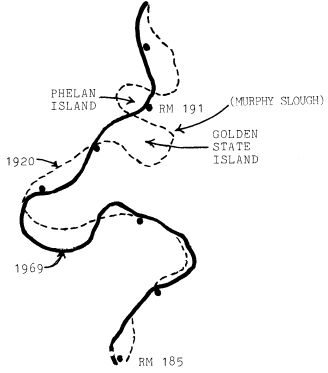
Figure 1.
Centerline meanders of the Sacramento River near
Golden State Island, 1920 and 1969 (from Brice, 1977).
[1] Paper presented at the California Riparian Systems Conference [University of California, Davis, September 17–19, 1981].
[2] J. Fred Chaimson is Chief of the Flood Control Maintenance Branch for the State Department of Water Resources, Sacramento, California.
[3] George Carter, Manager of the M&T Ranch, Chico, California. Personal communication.
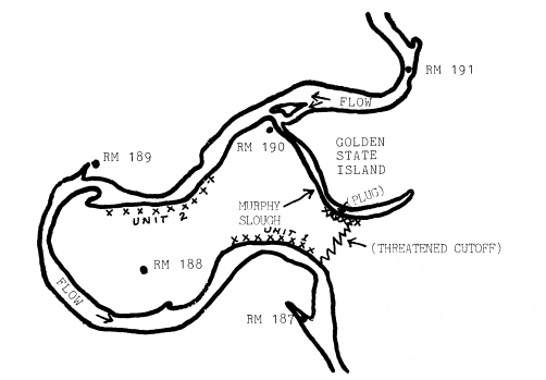
Figure 2.
Bank lines, Sacramento River, 1980, RM 187 to RM 191
(from Sacramento River Aerial Atlas, September 1980,
Sacramento District, US Army Corps of Engineers).
There are three alternative scenarios to this.
1. The resulting increased flow and debris would stay in the river channel and overtax the levees downstream.
2. The increased velocity and flow, coupled with a rising river bottom (caused by the adjustment of the eroding river bottom upstream), would cause the river to complete eroding of its natural levees somewhere between Sidds Landing (RM 178) and Kimmelshew Bend (RM 186.5), diverting the Sacramento River into Butte Basin (Brice 1977). This would cause widespread flooding in Butte Basin, possible failure of the levees of the Sutter Bypass, and loss of usefulness of the levees of the Sacramento River from Ord Ferry to Verona.
3. The third alternative is similar to the second except that the breakout would be to the west, flooding the nearby towns of Colusa and Princeton. This alternative is considered much less likely, however.
To forestall these possibilities, in 1974–75 the US Army Corps of Engineers (CE), with the usual State participation, constructed two revetment areas on the narrow waist of the peninsula and built an embankment or plug at the cutoff on Murphy Slough. The embankment was outflanked in high water of 1978 with some damage and again in 1980 with considerable damage, including erosion of the unit three revetment at the return to the river. Using emergency funds, the CE repaired and extended the embankment at the cutoff in 1980.
Flood Control Vegetation Studies
Recognizing the value of riparian vegetation in preventing flood damage under some circumstances, the Reclamation Board commissioned the firm of Murray, Burns, and Kienlen to identify areas of riparian vegetation of value to the stability of the river. Of the 38 sites identified, three of them are in this area and two of these, sites 35 and 36 (fig. 3), are pertinent to the problems of the division of flows at Murphy Slough.
Flood Control Planting on Golden State Island
In 1980, the Department of Water Resources and the Reclamation Board entered into an agreement with the Department of Fish and Game and M&T Ranch (the landowners) to provide for revegetation of the riverside slope of Golden State Island. The landowner agreed to provide right-of-entry for the revegetation and agreed not to remove or cause the removal of any resulting vegetation. In addition, he provided irrigation for the first planting and has agreed to do so for the replanting this year.
The planting plan includes:
1. grading of the riverside slope of Golden State Island to a three-to-one or four-to-one slope to prevent rain-caused gullying,
2. planting a mixture of Bermuda grass and rye grass on the slope face, and,
3. planting willow and cottonwood cuttings in the lower part of the slope in the fall season
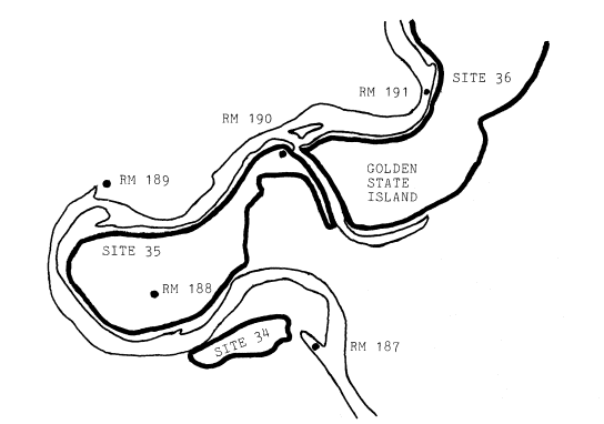
Figure 3.
Proposed riparian vegetation retention sites in vicinity of
Murphy Slough (from Murray, Burns, and Kienlan 1978).
in accordance with the availability of moisture, and extending the cuttings up the slope in succeeding years as appears necessary or desirable.
In late summer/early fall of 1980, the initial planting of the Bermuda/rye grass mixture was made. Unfortunately, before it was sufficiently established, high water in the relatively mild winter of 1980–81 washed out most of the lower part of the slope (fig. 4). This year, with the promise of irrigation sprinkling being available after mid-August, we will get an earlier start and have better growth before winter (fig. 5). Also, when the California Conservation Corps crews are available, after the fire season in the fall of 1981, we will have the willow/cottonwood plantings made.
One purpose of these plantings, in addition to obvious ones of habitat replacement and erosion control, is to encourage deposition of river-borne materials. Figure 6 shows the deposition of sediments downstream of a willow clump.
The plan is to promote a growth of willows and cottonwoods along the slope of Golden State Island, so that deposition will eventually reclose the mouth of Murphy Slough, reducing the flow of water into it and the resulting pressure on the Murphy Slough Cutoff.
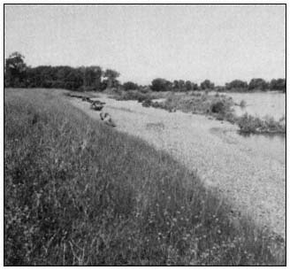
Figure 4.
Eroded bank of Golden State Island.
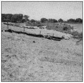
Figure 5.
Re-sloped bank of Golden State Island.
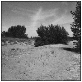
Figure 6.
Depositions downstream of willow bush.
Conclusions
While flood control maintenance at times involves removal of riparian vegetation to maintain channel capacity, there are selected areas where vegetation is beneficial for wave wash control, erosion control, and in this case sediment deposition, velocity reduction, and the redirection of flows.
Literature Cited
Brice, James. 1977. Lateral migration of the Middle Sacramento River, California. U.S. Geological Survey, Water Resources Investigation 77–43. 51 p. Menlo Park, Calif.
Murray, Burns, and Kienlen. 1978. Report to the Reclamation Board, Sacramento, California, on retention of riparian vegetation. February, 1978.