Geologic History of the McGuire Creek Area
A geologic history spanning the upper Hell Creek and lower Tullock formations at the McGuire Creek area can be constructed based on superposition, cross-cutting relationships, and interfingering between the facies described above. This sequence of events applies only to the study area at McGuire Creek.
Sediments within the upper but not uppermost Hell Creek Formation at McGuire Creek consist primarily of floodplain facies (Facies A; Plates 2-4). Floodplain facies also contain evidence of small-scale stream and extensive peat swamp development (e.g. TL: Tonstein Lignite). In situ dinosaur remains above and below the TL indicate that dinosaurs inhabited these floodplains.
The predominantly floodplain deposits of Facies A were then scoured by a series of major streams. Channels created by these streams were filled by sediments representing Facies B, E, and F. The thickness of IHS sets (up to 10 m; Sections 861, Q, R, Plate 3) and of the channel fills themselves (up to 20 m; Section II, Plate 4) indicate that these streams were very large. Over 15 m of relief is present on the contact between floodplains (Facies A) and channel-fill facies (Facies B, E, F; see Sections II through 811, Plate 4; and Sections H through B, Plate 2). The 15 m of relief indicates that stream channels were deeply entrenched into floodplains. As a result, the erosion surface developed on floodplain deposits (Facies A) is traceable for over 3 km (Sections K through R, Plate 3; Sections R through II and O through 855, Plate 4). An immense volume of previously deposited strata (mostly Facies A) was removed during these channeling events, and the likelihood that vertebrate remains were reworked is high. Channels were filled by vertically accreted (Facies F) or laterally accreted (Facies E) sandy sediment, while others were abandoned and filled primarily by finer-grained sediment that settled from suspension (Facies B).
A complex record of superpositional and cross-cutting relationships between laterally accreted (Facies E) and vertically accreted (Facies F) channels indicates the occurrence of multiple channel and fill events within this stratigraphic interval (below MCZ, above TL). Channels were deeply entrenched into pre-existing channel facies as well as floodplains (Facies A), and considerable reworking of vertebrate remains must have occurred. Eight mapped channel-fill units, six of which represent individual channel fills, are evidence of this complexity (Plates 1-4). Excellent exposures permit temporal sequencing of a limited number of these channeling events (a simplified version of channel-fill relationships is presented in Figure 5 and should be referred to in the following discussion). Superpositional and cross-cutting relationships indicate that the oldest demonstrable channel fill (of the six that were individually mapped) is the Little Roundtop Channel, which is scoured and overlain by the Second Level Channel (Plates 3, 4). The Second Level Channel is cut by both the Black Spring Coulee and Upper Tedrow Channel fills (Plates 3, 4). The Upper Tedrow channel cuts both the Brown-Grey and "Lower Tedrow" channel fills (Plate 3) ("Lower Tedrow" and Upper Tedrow channels may be equivalent, see section below on The Tedrow Area). These cross-cutting relationships reveal that both the Upper Tedrow and Black Spring Coulee channel fills are younger than the Little
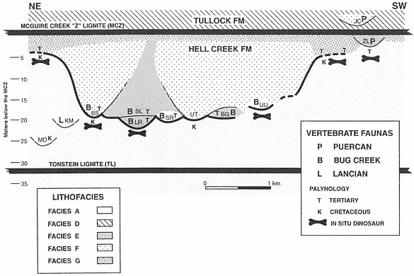
Figure 5
Schematic stratigraphic relationships of lignites, channel fills yielding vertebrate faunas, floodplain deposits
with in situ dinosaur remains (horizontal long-bone figures), sediment samples analyzed for pollen, and age
interpretation of palynofloras. Horizontal distance depicted is approximately 5 km in NE-SW orientation.
Channel fills (or Local faunas) are: (MD) Matt's Dino Quarry; (KM) K-Mark; (BS) Black Spring Coulee;
(LR) Little Roundtop; (SL) Second Level; (SR) Shiprock; (UT) Upper Tedrow; (BG) Brown-Grey Channel;
(UU) Up-Up-the-Creek; (ZL) Z-Line; (JC) Jacks Channel. KM and MD are not superpositionally overlain by
the MCZ as shown, but are actually at the tops of isolated buttes.KM, MD, UU, and SR could be either
Facies E or F. Heavy line denotes the erosion surface created by successive channeling events.
Roundtop Channel. Temporal relationships that remain uncertain are those between the Black Spring Coulee and Upper Tedrow, Brown-Grey and Little Roundtop, and Brown-Grey and Second Level channel fills. Physical relationships of the Z-Line Channel to any of the other five channel fills cannot be determined.
Three types of vertebrate assemblages (Lancian, Bug Creek, and Puercan) were collected from lag deposits in Facies E, Facies F, or undifferentiated channel fills within this stratigraphic interval. Z-Line (Facies E) is the only channel fill that preserves a Puercan fauna below the MCZ (refer to Figure 5). Bug Creek assemblages are present in the Little Roundtop, Second Level, Black Spring Coulee, and Brown-Grey channel fills, and the Shiprock and Up-Up-the-Creek sites. A Lancian assemblage is present only in the K-Mark Channel, an erosional remnant of a channel fill of unknown size and facies (Plate 3). Matt's Dino Quarry yielded an associated hadrosaur skeleton in a channel fill of undetermined facies (Plate 3), but mammals were not recovered.
The presence of Lancian, Bug Creek, and Puercan vertebrate assemblages in nearly identical facies in the same stratigraphic interval undoubtedly indicates that some degree of faunal change was occurring at this time. However, because of discontinuous exposures and the lenticular nature of channel facies, temporal sequencing of the three assemblages by superpositional or cross-cutting relationships cannot be determined. Interpretations of faunal change at this stratigraphic interval are ambiguous because they cannot be clearly supported by a superposed stratigraphic sequence of faunas.
Channel fills (Facies B, E, F) commonly fine upward and/or grade laterally into floodplain deposits (Facies G). These floodplains were accreted in unison with channel migration (Facies E) or were developed after vertically accreted channels (Facies B, F) were filled. Facies G floodplains also overlie Facies A floodplains. Areas that preserve this relationship are Sections II and 811 (Plate 4; Figure 5, base of BS traced to left) and Sections B through H (Plate 3; Figure 5, just right of UU, then traced to right). These sections show that channels (Facies F) which produce Bug Creek assemblages (Black Spring Coulee Channel) interfinger with floodplain deposits (Facies G) that contain aquatic vertebrates but lack dinosaurs. In the absence of a facies bias, it appears that the lack of dinosaurs in Facies G floodplains indicates that they were extinct by this time, at least locally. Paradoxically, where it can be determined, floodplains (Facies G) that lack dinosaur remains appear to have accreted in unison with channels (Facies F) that yield dinosaurs in lag concentrations (Section II, Black Spring Coulee Channel, Plate 4; Sections H-B, Plate 2). However, the presence of dinosaur remains in these channel fills is probably the result of reworking (see Lofgren at al., 1990). Reworking would explain why disarticulated remains of dinosaurs are present in channel facies (Facies F) but are absent in contemporaneous floodplain facies (Facies G).
Based on topographic elevation, the stratigraphic level of the basal lags of channels (Facies E, F) which contain Bug Creek assemblages are equivalent to floodplains (Facies A) containing in situ dinosaurs. However, lateral correlation of Facies F channels containing Bug Creek assemblages indicates that these channels interfinger with Facies G floodplains, not Facies A floodplains (Sections II through 8111, Plate 4; Sections B through H, Plate 2). This is a reflection of the deep entrenchment of channels into older floodplain
deposits (Facies A), where as much as 20 m of relief is observed. Therefore, correlation of facies provides a more reliable method of determining relative age than elevation or relative (to laterally persistent coals) stratigraphic level. Analysis of facies relationships of vertebrate-bearing fluvial deposits is critical because faunas present at the same stratigraphic level or elevation could differ significantly in age.
In contrast to the examples where channels containing Bug Creek assemblages can be traced into age-equivalent floodplains, the relationship of channel fills bearing Puercan or Lancian vertebrate assemblages to age-equivalent floodplain deposits (Facies A or G) cannot be determined. The K-Mark Channel and Matt's Dino Quarry site are located at the top of isolated buttes, making lateral correlation to floodplain deposits impossible. The margins of the Z-Line Channel (Facies E) are not exposed in contact with floodplain deposits.
Complete channel-fill (Facies B, E, F) sequences fine upward into floodplains (Facies G) and are all overlain by a laterally extensive lignite (Facies C), the MCZ (base of the Tullock Formation). This indicates that, following the episode of major channeling and erosion, a large peat swamp was developed which blanketed most of the study area. This swamp was in turn replaced by development of extensive areas of standing water, represented by thick sequences of pond deposits (Facies D).
Pond deposits (Facies D) are overlain by fluvial sediments that aggraded in various depositional settings. Of interest are channels (Facies F) with lag concentrations containing vertebrate fossils that are deeply entrenched (up to 15 m) into pond deposits (Facies D) overlying the MCZ (Facies C). These channels, for example, Jacks Channel (Plates 2, 3), contain Puercan assemblages (which lack dinosaurs and typical Lancian mammals). Remains of dinosaurs are not present above the MCZ in the McGuire Creek area, and apparently dinosaurs were extinct by this time (but see Rigby, 1989).