1—
The Historical and Geographic Background of Mobility
The purpose of a geographic description in anthropological studies is to acquaint the reader with the physical terrain and climatic conditions in which specific human behavior takes place. This is only part of the goal I have in mind here. The individuals and families that are the focus of this study have conveyed, indeed, have instilled in most of their offspring, a regional, familial allegiance to Baja California. The peninsula was the home of their fathers and mothers and the birthplace of the families, like my own, now in San Diego. This deep feeling was produced by the Californios' close ties with the geography and families of the peninsula. They tell stories not only about people and social events but about places in the desert and the mountains and in the hometowns from which they came. To migrants on the difficult desert routes north and south, place-names and geographic particulars acquired special meanings as they became part of social interactions and individual histories.
As geography is tied to the movement of twentieth-century migrants, so too is it intimately tied to early historical processes. Geography and climate in the peninsula were the single barrier that consistently defeated early attempts at colonization. And once colonization and settlement occurred, only unique geographic locales allowed Spanish settlement. The majority of the peninsula was never penetrated. Because of geographic obstacles, roads and paths seemed to develop only in naturally passable areas between early missions and towns. These same paths became wagon roads and main routes be-
tween the early settlements in Baja and Alta California. The roads were well but sparsely traveled and in the twentieth century they were the main arteries that connected the migrants of this study to the developing frontier. Peninsular geography maintained a dominant role throughout the colonial period and into the present. In 1972, when the first transpeninsular highway was paved and completed, it followed much of the early route of the original El Camino Real.
The Geography
Baja California was born about twenty-five million years ago. After quiet millennia the San Andreas fault split California and northwestern Mexico apart, creating the Gulf of California. Although this action was a slow process and continues today, the result was an isolated peninsula, approximately eight hundred miles long, torn away from the motherland some hundred miles across the gulf. As the break came the peninsula was slowly uplifted and tilted. The land became a broad, gentle, rolling plain. The old river systems that had drained across Mexico into the Pacific were cut off and began to flow into the gulf. The creation of the gulf produced current and air pressure systems along the peninsula that increased aridity. Today the peninsula is dependent for rainfall on outside pressure systems in the north and northeast.
The flat alluvial plains and deserts are broken by abrupt, jagged peaks dispersed throughout the peninsula. These mountains have been described as "granite blocks." Deserts and plains have earned the land a reputation for fiery heat and distinctive cactus vegetation. These extremes have forced modern as well as historic travelers in the peninsula to make their way between the peaks and through the deserts—for there was no other way.
Natural historians generally break the peninsula into three regions (Coyle and Roberts 1975; San Diego History Museum 1977; Hendricks 1971 ), primarily for ease of description. Typically, there are no distinct beginnings or endings of ecological zones. These three zones are the northwestern or frontera zone, the desert zone, and the cape region. Each zone delimits specific flora and fauna as well as specific climatic conditions.
The Northwest:
The Frontera
The first ecological zone is the northwestern, often referred to as the frontera in Baja California history. The frontera has always been the northern frontier zone of Baja California. This zone includes the present U.S.-Mexican border region and extends south to El Rosario about 360 miles. It is also called the California region because of its topographical similarity to Southern California. This area consists primarily of the high mountains in the northwest, but the peaks of the Sierra de Ja Gigante and the range of Las Tres Vírgenes (a recently extinct volcanic chain) are often included because of their vegetation. This zone consists basically of the peninsular range, including the Sierra Juárez and the San Pedro Mátir range. The granite peaks of the north range rise over 5,000 feet in elevation and encompass an area some 160 miles south of the Alta California border. Sections of the Guadalupe and Cedros islands and the west coast strip from San Diego to San Quintín also form part of this region. The major types of vegetation are coniferous forests, piñon and juniper woodland, chaparral, and coastal sage. In the northwest the native Cucupah, Pal-Pal, and Southern Diegueno have forested these regions, and today piñon nuts are collected and sold commercially by families in the mountains.
The Desert
The majority of land on the peninsula is desert. This desert runs the entire length of the peninsula, beginning with the San Felipe Desert on the east side of the northern mountains and extending to the Vizcaíno Desert on the Pacific in a long midsection. The central desert, beginning south of El Rosario, includes the Vizcaíno on the Pacific, branches out toward the Bay of La Paz in the south forming the Gulf Coast Desert, and includes the Magdalena Plain on the west.
The central desert begins just south of El Rosario and ends about six hundred miles south near La Paz. This is a lush desert that boasts rugged peaks and clear, dry skies. The diverse vegetation is generally of low growth, except for the giant cardon and cirio, but it is widely spaced, leaving flat sand surfaces for the zigzagging of travelers. The desert is bounded by the jagged peaks of the Sierra de la Gigante on the southeast. On the west the sandy flats of the Vizcaíno Desert extend to the Pacific Ocean.[1]
Before the arrival of the Spanish in the sixteenth century the central
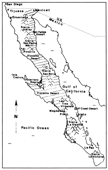
Map 1.
Baja California
desert was the most populated region. Of a total estimated population of 50,000, about 25,000 people lived in the central desert (Aschmann 1967). The early missionaries coerced the native groups into Spanish-style settlements and cut off their balanced pattern of seminomadic foraging. This alteration in life-styles, coupled with the decimation wrought by the introduction of European diseases, resulted in the total extermination of Indians from this region.
The extreme aridity and economic sparseness of the central desert isolated the northern region from the cape. Although the north was settled by Spanish from the south, the central region was passed over (for the fertile north) and left virtually unpopulated. During the mid and late 1800s some gold mining prospects brought small populations of miners from both the north and south into these areas. Once the ore was gone, people abandoned the region. Today small pockets of people live throughout the area in deserted mining and mission spots. Today it is the region least populated on the peninsula.
The Cape
The Tropic of Cancer bisects the cape zone, which begins near Loreto, in scarce mountain forest and fans out to include La Paz and the southern tip of the peninsula. The vegetation there is primarily tropical, although the cardon cactus is still present among lush growth and a variety of tree life. As in the other regions, the mountains—the Sierra La Victoria—are rugged peaks rising to heights of over 7,000 feet.
The towns of the cape are among the oldest in the peninsula, and it is in this region that the Spanish first met their defeat. La Paz was the first site of discovery in 1533 and there in 1535 the first settlement in the Californias was begun. But Indian uprisings and the harsh environment forced the Spanish out. Settlers returned in 1596, establishing the settlement permanently. La Paz, the capital of Baja California Sur, is the gateway to San José del Cabo and Cabo San Lucas, where land's end meets the turquoise water of a tropical Pacific.
The Climate
The climate, like the geography of the peninsula, made initial settlement difficult for the Spanish. The peninsula was viewed as a hot, arid, and inhospitable frontier in which all settlement relied on imports from the
mainland across the gulf. Early as well as modern travelers consistently remark about the peninsular heat, the lack of water, and the vast stretches of desert terrain. The Jesuit Baegert wrote in the eighteenth century:
If I wished to describe California (of which it is said in jest that of the four elements it received only two: air and fire) in a few words I could say with the prophet in the sixty-second psalm that it is a waterless desert, impassable because of rocks and thorns, or that it is a long rock jutting out of the sea, overgrown with extraordinary thorn bushes, and almost devoid of grass, meadows, forests, shade, rivers, and rain . . . (Baegert 1772)
Baja California's general location between the Tropic of Cancer and 32° 50́ N contributes greatly to the varying climatic conditions throughout the peninsula. The greatest climatic influences are the ocean currents and winds that bring precipitation in varying amounts. Annual peninsular precipitation varies from no rainfall in some localities to thirty inches in the higher mountains of San Pedro Mártir. The California current, originating in the western Pacific, travels north along the coast of Japan, circles across the Pacific around 40° N, then turns south along the west coast of Alta California and Baja California (Schwenkmeyer 1977). It brings cool ocean temperatures (55°–65°F) and produces mild temperatures and frequent fog on the west coast of the peninsula. Because there are no significant mountain ranges on the west, the great plains of Magdalena and the coastal sections of the Vizcaíno Desert are generally cooler than other desert regions, averaging 75°F. The California current dissipates at the cape, where both land and water temperatures are higher.
The cape region receives much of its precipitation from the west coast of Mexico. This comes in the form of tropical cyclones known as chubascos, which generally occur in late summer or early fall.[2] Only the cape in the far south, the iushest region on the peninsula, and the mountains of the north receive rainfall that at times exceeds 40 inches annually (San Diego Natural History Museum 1977:2). Cyclonic air masses from the northern Pacific bring winter storms to the northern part of the peninsula, but these rains dissipate as they head south, extending to about El Rosario, a little over 200 miles south of Tijuana. The average annual precipitation in Tijuana and San Diego is 10 inches (8 inches in Ensenada and 5 inches in San Quintín).
The central peninsular desert and the northern cape, north of La Paz, is the country from which early exploratory travelers headed inland and from which twentieth-century migrants moved north. It is the hottest and driest region of the peninsula and has presented the most consistent challenge in all periods of exploration and settlement.
Discovery and Settlement
The Spanish quest for discovery and settlement in the sixteenth and seventeenth centuries established a northerly pattern of movement. Although I provide a brief history of the settlement of peninsular mission towns, my primary focus here is this mobility and the lines of communication that became prominent in Baja and Alta California during this period. This movement pattern is embedded in the processes of discovery and encompasses the important events that brought discoverers and settlers to the peninsula and eventually to the Frontera in the eighteenth, nineteenth, and twentieth centuries.[3]
Before discovery California had been a mere legend, fueled by tales recounted by mainland natives. The land was believed to be an island of fabled Amazons in which gold and treasure would surpass all booty taken in previous pursuits. This legend played an important role in the successive attempts at northward expansion, in the discovery of California (named after the legendary queen of the Amazons), and in the persistent, though incredibly difficult, exploration of the gulf and peninsula of Baja California.
When the Spanish, under Cortéz, entered Baja California during the first century of exploration, they met a hostile land that was to defeat many settlement attempts. Yet however poor the economic possibilities and resistant the geography and climate, explorers continued to attempt settlement and colonization on the peninsula. The search for more suitable settlement sites continued, and when the more hospitable lands and coast of Alta California were discovered, Baja California became a migratory way station to the north. Missionaries, settlers, and the Manila galleons skirted her shores as they headed north to Alta California and returned south to New Spain.
The pattern of northward movement eventually left Baja California virtually unsettled and physically unconquered. Exploration had
stemmed first from the quest for a western sea passage to the Indies and then from the race for the fabled riches of the new northern continent. Baja was a desolate place that offered ceaseless hardship. Only a handful of missionaries saw this frontier as worthy of time and dedication and they eventually developed the towns and routes that likewise headed north.
The Context of Discovery
Cortéz became the key figure in the discovery of the peninsula because when he heard of the island legend soon after conquering Mexico[4] he became obsessed with its discovery and settlement. He first heard of an Amazon province through the Tarascans, and in 1524 he wrote Charles V of the existence of such a land, rich in gold and pearls, to which Colima natives had traveled. In 1522 (when word reached Spain of Magellan's successful voyage to the Philippines via the southernmost straits of the Pacific), Cortéz ordered his lieutenants west in search of gold mines and a water passage to the South Sea. They explored the isthmus of Tehuantepec (Cristóbal de Olid), Oaxaca (Pedro de Alvarado), and the coast of Guerrero (Pedro Alvarez Chico). In May of that year Cortéz began to outfit and build a fleet that was to be used for an expedition in search of the rich islands off the Pacific coast.[5] But Cortéz had to wait five years before ordering the fleet into the Pacific because the king supported a new expedition from Spain. Charles V hoped to establish a direct route from Spain to the Indies in order to take direct control over the Spanish spice trade. But this expedition was lost and the king issued Cortéz a Royal Order of Pacific Exploration (Schurz 1939:15). Cortéz lost no time and in 1527 sent his cousin, Alvaro Saavedra Leron, on an ill-fated voyage to the Spice Islands. Saavedra was lost in the Moluccas attempting to find a return passage to New Spain, but the expedition had immediate consequences for successive sea exploits. The search for a return route from the Indies became a prime goal in ongoing exploration to counter the Portuguese monopoly of the Indies trade.[6] Spain's immediate hope to take an active part in the trade was to establish a western route via the New World.
The struggle between the major explorers and conquistadores also forced Cortéz out of mainland exploration and into the Gulf of California. In Mexico City the infamous Guzmán, as member of the audencia,
began using his powers for personal gain, and the viceroy Mendoza attempted to limit Cortéz.[7] Although Cortéz had been issued the royal license to explore and conquer the islands of the Pacific and the unknown coasts of the mainland, Guzmán wrote the king that he (Guzmán) planned to search for the country of the Amazons.
Cortéz, attempting to reclaim what had rightfully been his by earlier conquest and exploration, in 1532 sent Diego Hurtado de Mendoza just north of Guzmán's territory. Mendoza was killed by native Sinaloenses but Cortéz did not give up. In the following year the peninsula was "discovered." Cortéz sent two ships into the gulf, but they became separated early in the voyage, and one managed to land on the peninsular shores. One ship returned to Acapulco and the continuing vessel was seized by Ortuno Jiménez in a mutiny. Jiménez, in 1533, became the first European to sail into the Bay of La Paz and land on the peninsula.
Jiménez received no welcome, and from the outset the peninsula became known as inhospitable country. The mutineering captain and most of his men were killed by natives, but a few men managed to escape to the mainland where they were seized by Guzmán. One survivor escaped, however, and reached Cortéz with news of the discovery of an island rich in pearls and gold (Wagner 1929:6).
When Cortéz learned of the discovery, he lost no time in preparing a follow-up expedition. Cortéz himself commanded this fleet. He set sail in 1535 with provisions for a settlement and entered the present Bahia de La Paz. Baja California again gave no welcome and was to become as isolated as if it had been the island it had always been deemed by the Spanish. The Europeans found the peninsula harsh. There was no prosperous settlement and the colony struggled along until 1537. Then Cortéz found it necessary to return to Hew Spain to defend his rights of conquest and acquisition and he never again saw the New World. The settlement at La Paz failed and the peninsula was left unsettled for over a century and a half.
This earliest expedition to Baja California as well as those that were to follow in the next century contributed knowledge of sea travel along the gulf. The siting and attempted settlement of La Paz created sealanes that the Spanish continued to use between the cape and the mainland. Furthermore, La Paz became a major harbor from which the Spanish galleons explored both gulf and Pacific. For the next two centuries mobility in Baja California was restricted to the sea.
After Discovery:
Exploration and the Manila Galleon
By the early 1540s, just twenty years after the conquest of Mexico, both coasts of the peninsula had been explored and the northern territory of California was soon to be penetrated. In 1540 Díaz entered western Baja California by land via the mainland route that still stands today. Two years later Cabrillo stood at the Pacific. The principal routes to the Californias had been discovered, but unlike their mainland counterparts, they would not be used for immediate settlement. California remained unimportant except insofar as its coasts could aid in the burgeoning Manila trade.
The Manila Galleon
The route of the Manila galleon[8] was paramount not only in the further exploration of the California coast from Cabo San Lucas to the northern California region but in the establishment of permanent sea-lanes between the north and south. Once established, these sea routes helped maintain communication between Baja California, Alta California, and the mainland. These sealanes remained permanent migration routes between Baja and Alta California to the present. At the turn of the twentieth century families in the extreme south used these same passages as primary migratory routes between San Diego and Baja California.
The California coast became an immediate concern of the Spanish Crown because of the need for coastal refuges for the Manila galleon on its long voyages. The winds and ocean currents of the Pacific produced natural sea-lanes (the California current) that brought the galleons to the cape, and Cabo San Lucas became a natural resting spot where the ships could readily put in for water and repairs. But additional ports were needed elsewhere along the coast, and new explorations centered around their discovery.
The ensuing years saw several exploratory voyages to the northwest to seek a passage for the Philippine galleons. These included the voyage of Sebastian Rodriguez de Cermeño, who sailed first to the Philippines from Acapulco. Almost simultaneously with Cermeño's return, the viceroy commissioned Sebastian Vizcaíno to explore the Gulf of California and to establish settlements on the peninsula (Bolton 1908:44). On two successive voyages in 1599 Vizcaíno explored the
inner gulf coast from La Paz and later Magdalena Bay, Cedros Island, San Diego Bay (which received its name on this voyage), Santa Catalina, and Monterey Bay (Bolton 1908:46–48). But the search for a port on the Pacific coast ended with the voyage of Vizcaíno. He had explored and mapped the Pacific coast thoroughly but had failed to secure a port for the galleon.
Until the late sixteenth century the exploration of the Pacific coast had kept pace with the general Spanish penetration of the continent, but continuing failure to secure good settlements and harbors along the coast and the growing recognition that the peninsula was a marginally productive region combined to shift attention away from the coast and peninsula. The seventeenth century witnessed surging development on the mainland while Baja California stagnated. This peripheral nature of Baja California within the New Spanish system was furthermore compounded by the threat posed by the English buccaneers, Drake, Cavendish, and later Woodes Rogers and George Shelvoke (Englehardt 1929:29–31), who all roamed the open seas plundering Spanish vessels. In addition, Dutch freebooters had established themselves at Pichilingue outside of La Paz and were a constant menace to mainlanders (Engelhardt 1929:80).
The Spanish population of the mainland had settled in the sixteenth century and by 1550 had begun to branch northward to open new lands and eventually new economic bases for the Spanish. Mexico itself was becoming more and more independent of Spain. The clergy, who had entered Mexico during the conquest, made the northern expansion successful. The church made a great investment in evangelization on the mainland, but this interest was not to be seen in Baja California until the next century.
In brief, Baja California provided no riches, no great cities, and no great populations to evangelize. Furthermore, colonists saw Baja as a barren wasteland in which the European could not live. All the settlements attempted between 1533 and 1680 had failed. There was no water, and all provisions had to be imported across a sea plagued by dangerous currents and winds. The only predictability in Baja California was the lack of rain. Expeditions up the Pacific coast in search of suitable harbor and settlement locations brought no immediate benefit to the Spanish. They did place California on the cartographic map of the world and set the stage for communication, future settlement, and mobility in the Californias.
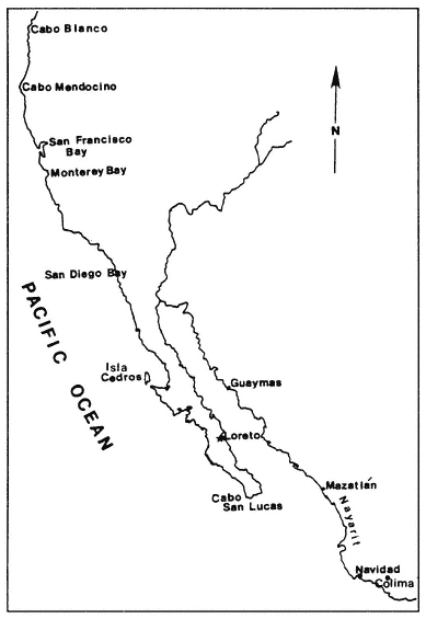
Map 2.
Pacific West Coast of Alta and Baja California
The Settlement and Colonization of the Peninsula
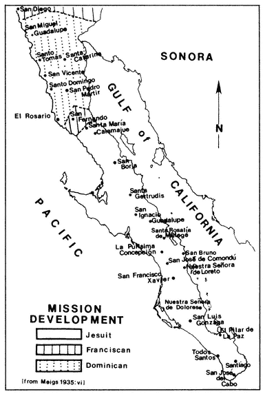
Not until 1678, over a century after discovery, did the Spanish government make a determined effort to establish a permanent settlement in Baja California. The government made plans, built ships and entrusted the spiritual conquest of California to the Society of Jesus (Engelhardt 1929:83).[9]
The Jesuits, Franciscans, and Dominicans
Fray Eusebio Francisco Kino entered the Baja peninsula in 1683 and became the key figure in the establishment of the Jesuits in Baja California. Kino's expedition went first to La Paz, but because of conflicts with indigenous groups he was forced north to San Bruno. There Kino and his fellow friars established contacts with the natives of the region and began learning their language. San Bruno was a barren outpost and displeased the military contingent, under the command of Admiral Isidro Otondo y Antilion. They decided to abandon the settlement. Kino begged to remain on the peninsula and, when forced to leave, promised the natives he would return. Impressed with the Indians' good nature, Kino committed himself to the establishment of a mission chain in California. He thought the natives were ready for conversion and he visualized future mission sites where native rancherías were located.[10] (Some of these sites became twentieth-century townships from which migrants headed north along the same trails and roads developed in the missionary period.) Although Kino was committed to return to San Bruno, he could find no immediate support in New Spain from either his superiors or the viceregal government. He was assigned to Sonora, where he remained his entire career.
The difficulty of gaining authorization for the peninsula mission chain illustrates the unfavorable disposition of the Mexican religious and political authorities. The government had made successive expenditures in the Californias, had received little in return, and had abandoned any thought of successful economic gain. The peninsula had become a reality of successive failures. There was no gold, no great population, only a barren, inhospitable, and waterless region from which no civilized man could squeeze even his subsistence. The difficult condition of life there secured Baja California's isolation from the mainland even after colonization, settlement, and population of the peninsula had taken place.
Juan María de Salvatierra, the new visitor-general for the Jesuits in Sonora and Sinaloa, met Fray Kino a year after his return from Baja and became empassioned with the concept of developing a mission chain in California. For the next ten years Salvatierra and Kino argued for the mission chain at all levels of religious and governmental administration. But not until 1696 did they find sympathetic ears. The idea of a mission settlement in Baja California was then finally approved (by the superior general of the Jesuits and the audencia), whereupon Salvatierra solicited alms for the project. Fray Kino was forced to stay behind because of an Indian uprising in Sonora. Before Fr. Salvatierra left Fray Francisco María Pícolo was named to replace Kino, but Salvatierra could not wait and left for the peninsula; Pícolo joined him later (Engelhardt 1929:101–102).[11]
Fr. Salvatierra embarked for the peninsula in 1697, accompanied by Captain Luis de Torres y Tortolero, first ensign of the garrison of California, five soldiers, and three mainland Indians (Venegas 1759:227). This small group[12] formed the basis for a successful settlement and for the establishment of a permanent mestizo/criollo populace in the Californias. (Among these individuals was Nicolas Marquez, a Sicilian soldier whose descendant, Loreto Marquez, is a principal figure in the family migration I describe in later chapters.) Father Salvatierra and his group landed at Loreto (named after Nuestra Señora de Loreto), but it took them two years to establish themselves. During these first two years Salvatierra learned the local language and began successful evangelization and conversion. These years were not without their difficulties. Several skirmishes with Indians, confrontations between local groups, and the struggle for subsistence made frontier life on the peninsula a constant threat to survival. All provisions continued to be supplied from the mainland. Regardless of the hardships, by 1700 there were seventy colonists at Loreto, including Spaniards, mestizos, and Christian Indians from Mexico (Engelhardt 1929:105–113).
Loreto became not only the first successful settlement in the Californias but also the capital and hub of peninsular activity. As inland settlements grew, the majority of Spanish and mestizo movements into the interior came from Loreto. The town was the political and religious capital of the Californias and the base of operations for all religious and military expeditions that entered the northern frontera region of the present U.S.-Mexico border.
The second mission site, San Xavier (1699). was vitally important
because in addition to expanding the Spanish colonial territory it provided a peninsular source of provisions and firmly rooted the Jesuits on the peninsula. Friar Juan de Ugarte, who had joined Salvatierra and Fray Pícolo (Kino's replacement) on the peninsula, made San Xavier the breadbasket of the colony. There he cultivated the first grapes in the Californias, exported the first California wines to the mainland, bred horses, raised sheep for their wool and wheat for bread. He taught weaving and carpentry and was known to participate in all the work of the mission (Engelhardt 1929; Venegas 1759; Clavigero 1937, 1971).
By 1702 the mission chain was a reality and the Jesuits had managed to secure further support in New Spain. Three missions had been founded: Loreto, San Francisco Xavier, and Nuestra Señora de los Dolores del Sur. Furthermore, rancheías throughout each of the mission areas were visited regularly by the fathers. That same year Fray Pícolo went to Mexico for support of the missions of California. In addition to securing much needed supplies, Pícolo managed to obtain donations for new missions. These missions were to be San José de Comondú, La Purisma Concepción, Our Lady of Guadalupe, and Santa Rosalía de Mulegé.
The Jesuit period came to an abrupt end when the society was expelled from the New World in 1767. But in a seventy-year period the Jesuits had succeeded in establishing fourteen successful mission sites that extended from the cape at San José del Cabo to Santa María de Calamajue at about the thirtieth parallel. Their explorations of the northern area paved the way for the Franciscan entrance into the north and set the stage for the initial settlement of the Californias.
Although the Jesuits succeeded in colonizing the peninsula, the natural environment confined them to specific areas. Geography remained a constant barrier to missionary as well as Spanish colonial. They were forced to use the natural paths and roads used by native Californios in seasonal migrations between springs, water holes, and areas of subsistence gathering. Individual Jesuits founded mission sites within areas of denser native populations and through visitas to neighboring and surrounding rancherías the religious chain spread throughout the southern portion of the peninsula. Once established at mission sites, settlers continued to use the natural paths and travel routes between towns and localities.
The Jesuit experience in the peninsula set the pattern of settlement and mobility in the peninsula. Mission sites grew into small but prominent populations of individuals who came to call Baja California Sur
their home. The combined effect of the geographic barriers of the peninsula and the isolation from the mainland created strong ties between towns and their populations.
At the time of their expulsion, the Jesuits had reached the boundaries of the frontera region in the north and had established the present route of El Camino Real. It became the main artery to the north as it passed through prominent mission and town sites. In later years news about the north came through the mission spots as travelers moved between the sectors.
Following the Jesuit expulsion the Franciscans (1768) and Dominicans (1773) entered the peninsula, but they turned the emphasis of settlement toward the north. Baja California Sur reverted to its peripheral position as it lost the interest of the missionaries. The move toward the north was the result of growing competition between the Dominican and Franciscan orders as well as the product of the king's desire to control northern Pacific ports. Upon expulsion of the Jesuits the Dominicans had petitioned for their share of California. But the Franciscans had already established themselves in San Diego and Monterey. These ports were vital to the Crown and the government of New Spain required their immediate occupancy. Since the Franciscans had laid claim to the ports, under Fray Junipero Serra they became advocates of the settlement of Alta California. The resulting conflict between the orders resulted in the division of California. Through a concordat in 1772 the Dominicans took charge of the old Jesuit missions, which the Franciscans had allowed to fall into disrepair, and were assigned the frontera region extending from the last northern missions of the peninsula almost to San Diego. The Franciscans took charge of Alta California, including San Diego and the area north. Three Franciscan sites were established north of San Diego in 1772, while the Dominicans extended the peninsular missions north to the frontier.
The Dominican chain facilitated travel and communication between the Californias. Once missionaries had pacified the natives, the frontera became safe for travel to the north. The Dominican-dominated frontera became the northern connection to the southern peninsular towns as well as to New Spain on the mainland. The richer lands in Alta California became the targets of planned settlement, but Baja California remained a way station in the process.
Loreto, however, remained the religious and political capital of the Californias. All supplies, communication, and exploratory expeditions were initiated in Loreto. El Camino Real, as the developed route to the
Map 3.
north, kept the peninsula within the active northward expansion. Lines of communication were kept open for continuing expeditions as well as for later movement between the peninsula and Alta California.
The historical and geographic settlement processes that contributed to a regional pattern of mobility in Baja and Alta California were initiated by the Spanish in their explorations along the Pacific coast in the sixteenth and seventeenth centuries. The progress of the missionaries from south to north and their ultimate emphasis on the frontera region and Alta California strengthened the northern orientation of these patterns. As a result, the peninsular population was continually oriented northward. The region from Monterey to the cape became a Spanish-dominated sociocultural domain in which the towns of the peninsula became points in a matrix of mobility and communication which lasted until the twentieth century.