The Oratory Terrace
This station, lying about two hundred meters above the ocean and some fifteen meters below the summit, offers a magnificent view of the seascape east of the island (Figs. 30, 31). Until we cleared away the sea campion, it flourished, almost covering the remains of two walls of the oratory. Beyond the terrace, on the other side of Christ's Saddle, the domes of the monastery's beehive cells are seen on the northeastern summit, with the dramatic silhouette of Little Skellig rising behind. In the background, the delicate curve of the mountains of the Iveragh Peninsula, more than eleven kilometers to the east, frames the seascape.
Over time, the oratory terrace has suffered so severely from the collapse of its retaining walls that it is perilous to examine, and its original
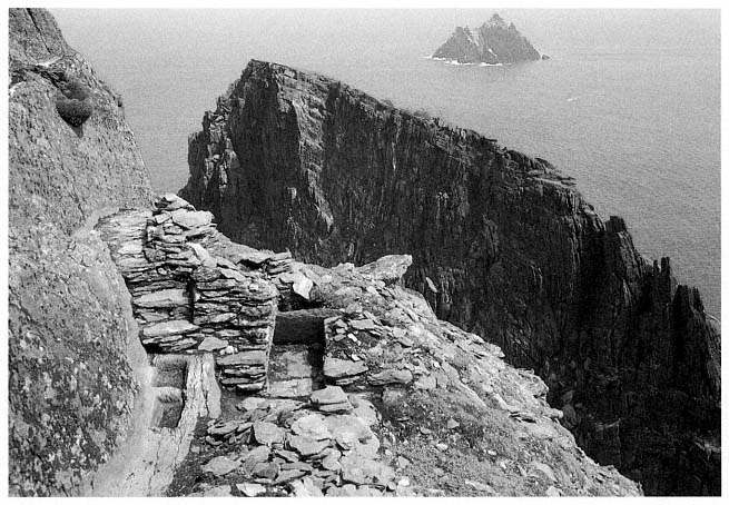
Fig. 31
Skellig Michael, South Peak. Oratory terrace, with the west wall of the oratory freed from its overgrowth of sea
campion, revealing a flagged path and steps descending to the water basins on the north side of the oratory.
Photograph by Jenny White Marshall.
form is hard to establish. O'Leary and Snodgrass, belayed by ropes, surveyed the site with plumb lines in the summer of 1982. In 1986, Rourke resurveyed the South Peak with a plane table, and on the basis of that survey he drew the plan shown in Figure 32. The surviving remains, according to his findings, are
1. The north wall and much of the entrance wall of an oratory.
2. Two interconnecting water basins located at the base of a flagged path at the northwestern corner of the oratory.
3. Flagstones under fallen masonry at the entrance to and in front of the oratory, believed to be the remains of a completely paved terrace.
4. A rectangular leacht , a low dry-stone structure shaped like an altar, at the place where Eugene Gillan's plan (see Fig. 11) shows three objects labeled slabs. Hidden from sight by a dense overgrowth of sea campion, this structure is probably what the Ordnance Survey plan of 1841 identified as a burial ground.
5. Midway between the oratory and the leacht , lying flat on its back, a cross inscribed on a slab that, like the leacht , was hidden from sight by sea campion. This is most likely the standing cross mentioned by Lord Dunraven in 1875.
6. A small extension of the terrace east of the oratory that contains two stone slabs placed on edge at right angles to each other (Eugene Gillan mentioned them but did not show them on his plan) and a third upright slab, or orthostat, hidden by sea campion, slightly behind the other two.
7. Fragments of masonry that once formed part of a retaining wall around the perimeter of the oratory terrace.
Many of these features, with the exception of the slab incised with a cross and the paving slabs, are visible in aerial photographs like that of Figure 29. They are described in the following pages.
The Oratory
The remains of this structure consist of much of the north wall and adjoining west wall. The north wall is the more intact because it was built on bedrock as close to the rock face as possible. Its maximum height is 1.35 meters above the level of the threshold. Corbeling is evident. The internal length of the remaining north wall is 2.55 meters; the internal width of the oratory wall is 2.1 meters, with a narrow entry (.57 meter) midway in the wall. Precise overall dimensions are difficult to determine owing to collapse, but when the proportions of the small oratory in the monastery are related to this structure, they yield an estimated length of 2.75 meters. On the western, entry, side there is a plinth approximately .36 meter above the level of the threshold.[10]
[10] Plinths on the east and south sides at a slightly higher level than the one on the western side are conjectured for two reasons: tradition and the knowledge that this arrangement increases the strength of a structure that has no plinth on the north side but a path 1.18 meters above the pavement level.
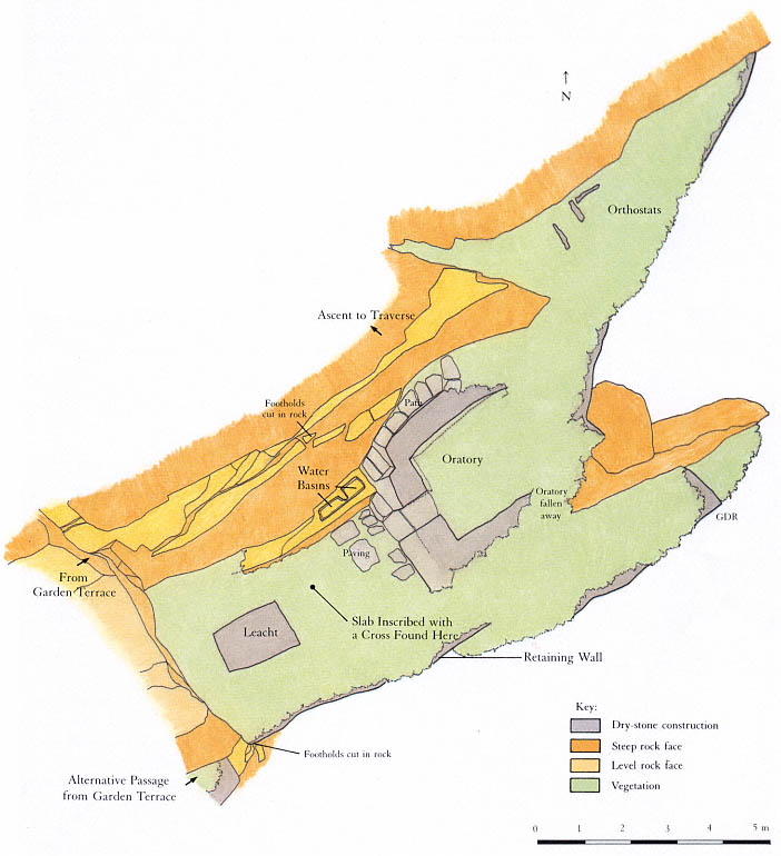
Fig. 32
Skellig Michael, South Peak. Plan of the oratory terrace by Grellan Rourke, based on the plane-table survey of 1986 made
by John O'Brien and Grellan Rourke, assisted by Aidan Forde of the Kerry Mountain Rescue Team.
These fragments of wall indicate a rectangular structure aligned east to west and built of dry-stone masonry. Of the buildings in a monastery of the Early Christian period, only an oratory fits this description. All oratories—and oratories alone—were rectangular structures with longitudinal axes running east to west. The monks of this period, by contrast, dwelt in circular houses, a custom inherited from their secular ancestors. A typical example of this architectural distinction is seen in the layout of the monastery that the monks of Skellig Michael built on the other side of Christ's Saddle. It comprises six circular beehive cells and two rectangular oratories, the larger one measuring 2.44 by 3.67 meters inside, the smaller one 1.83 by 2.44 meters.[11]
The dry-stone architecture of the hermit's oratory is typical of Early Christian oratories commonly found on the islands off the west coast of Ireland, where timber was unavailable. In part, their design translated into stone the curved walls and roofs of the cruck-built timber churches that abounded during this period on the mainland of Ireland, where timber was easily obtainable.[12]
The masonry technique of the hermit's oratory, as exemplified in the remains of the north and west walls, is identical with that of the two oratories in the monastery. The smaller of the two is illustrated in Figure 33. All oratories built in this style have very thick corbeled walls with stones laid horizontally; none use mortar, dressed stones, or a rigid system of coursing. The walls in these structures were built of well-chosen medium-sized stones filled in with small stones to produce a well-compacted, even surface.
The Leacht
At the western end of the terrace approximately one meter east of the rock face are the remains of a rectangular stone-built structure 1.1 by 1.6 meters; its present height above the level of the pavement is .45 meter (Fig. 34). The basic structure is well preserved, but the uppermost level has been damaged by weathering. This setting of stones is the remains of a leacht .
Leachta , square or rectangular structures built of rough, unmortared stones, are associated with Irish Early Christian monastic sites. Today they are found primarily at the island monasteries off the west coast of Ireland. Their original distribution is unknown, as they are easily destroyed, but because some have been found in northern Britain, we know they were not limited to the western coastline. Outstanding examples are found today in the monasteries of Skellig Michael, Illauntannig, and Inishmurray. A typical example of a leacht from Inishmurray is shown in Figure 35. It is a quadrangular mass of masonry roughly one meter high, with a tall engraved cross slab set in its center (Wakeman 1893, 71, Fig. 34).
The function of leachta has long been debated. They may have been used to mark burial places, particularly for special saints, or to house relics, mostly the bones of saints; or they may have served as places for prayer, either as stations of the cross or as altars for celebrating mass. It is quite possible that all of these conjectures are correct and that leachta served different functions in different times and places.[13] Only the systematic excavation of a carefully selected group of Irish leachta might ascertain their precise function
[11] Other well-preserved examples illustrating this distinction between the designs of oratories and dwellings exist at the monasteries of Inishmurray and Illauntannig, both built, like Skellig Michael, on treeless islands. For further discussion of the distinction between circular dwellings and rectangular oratories see Horn, 1973, 23–31.
[12] On the adoption of architectural features peculiar to timber construction in Irish stone churches see Leask, 1955, vol. 1, chaps. 5 and 6. His theory has been generally accepted (Thomas, Early Christian Archaeology , 1971, 75; and de Paor and de Paor [1958], 1967, 58–60).
[13] Thomas, in Early Christian Archaeology , 1971, 169–75, gives the best summary of our current state of knowledge.
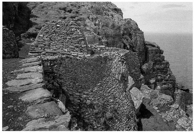
Fig. 33
Monastery of Skellig Michael. View from the south of the small oratory that served as the model for Grellan Rourke's
reconstruction in Figure 39.
Photograph by Walter Horn.
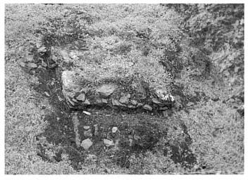
Fig. 34
Skellig Michael, South Peak. Remains of a leacht .
Photograph by Walter Horn.
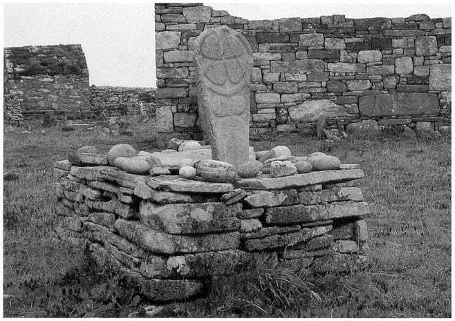
Fig. 35
Island monastery of Inishmurray, County Sligo. A leacht , referred to locally as altóir beag , "the little altar," one of
approximately fifteen leachta on Inishmurray of similar construction. Three lay within the monastery's walls; twelve
along the periphery of the island served as pilgrimage stations.
Photograph by Walter Horn.
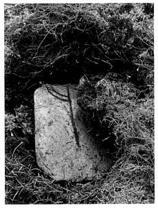
Fig. 36
Skellig Michael, South Peak. Oratory
terrace. The cross slab discovered in
1982 at the location indicated in
the plan of the terrace (Fig. 32).
Photograph by Lee Snodgrass.
Some leachta , however, are known to contain human bones. The larger of the two leachta in the Skellig Michael monastery is situated north of the large oratory; the other, smaller, one is built against the monastery retaining wall south of the large oratory. In the course of badly needed repair to the perimeter of these leachta , the National Monuments Service found some human bones. Because the bones were discovered by chance during the rebuilding of the wall face, not in the course of an excavation, no attempt was made to explore the leachta in depth, and the bones were returned to their original position.
The remains of a leacht on the South Peak oratory terrace give evidence of a structure too small to be the original burial place of anyone. Possibly this leacht was either a memorial shrine, containing the translated bones of a hermit, or an altar.
The Stone Slab Fragment Inscribed with a Cross
While taking measurements on the oratory platform, Snodgrass noticed the unusual shape of the top of a rabbit burrow. Carefully pulling aside a few tufts of sea campion, she discovered a smooth thin slab of slate with a ring cross engraved on it (Fig. 36). This is almost certainly the cross slab Lord Dunraven described in 1875 as "standing near" the oratory (see p. 18). It is a fortunate discovery because the design of the cross furnishes a clue to the date of the hermitage. Unfortunately, the slab is broken, and much of the upper part of the ring-cross design is missing. The missing fragment was not in any place accessible to surface inspection and would be difficult to find without excavation unless rabbits in the future decide to burrow in strategic places. The cross slab was placed in the care of the National Monuments Service.[14]
Such a cross slab located in the open space in front or to the side of an oratory is a classic feature of early Irish hermitages and monasteries, as Michael Herity has shown in a recent study (1984, 105–16). The chronological implications of the design on the slab are discussed in the Appendix.
The Water-Collecting Basins
To gain access to the oratory terrace, one follows a natural ledge with steps cut into it that zigzags down the face of the cliff to a flagged path below. The existence of this path was unknown until Rourke removed sea campion from around the north wall of the oratory. At the western end of the path, steps lead down to the oratory; at the foot of these steps a critical feature turned up: two interconnecting basins chiseled out of the rock (Fig. 37). Their shape and location clearly indicate that they were used for collecting water.
This dramatic discovery gave us tangible proof of our hypothesis that a hermit lived on the South Peak. Anchorites tended to reduce their dietary needs to the lowest margin, but water was an indispensable daily requirement. The purpose for planning and constructing sophisticated water basins could only have been to enable someone to inhabit this barren crag.
On the cliff face north of the oratory two man-made grooves direct water into the basins. Water was also collected and fed into them by a channel cut under the flagstone path, visible near its termination at the base of the steps. When the water reached a certain height in the first basin, it overflowed
[14] O'Sullivan (1987) believes that this slate slab may have been brought to the island.
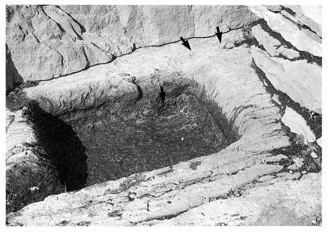
Fig. 37
Skellig Michael, South Peak. Oratory terrace. Detail of one of the water basins.
A channel under the steps of the flag-stone path ended at the groove (upper arrows) in
the rim of the basin at the upper right; a circular depression in the basin itself (lower
arrow) allows silt to settle. The end of the channel under the steps can be seen clearly
in Figure 31.
Photograph by Grellan Rourke.
into the second, slightly bigger, basin. This arrangement permitted the cleaning of one basin while water was retained in the second and also helped filter the water. Another component of this clever filtering system is the circular depression that collected silt at the feed end of the first basin. Careful consideration had been given to long-term use of these basins. They were near the oratory simply because there, coincidentally, the large fractured surface of the rock wall provided the best source of water.
This whole area was meticulously planned. That the masonry of the north oratory wall was built over the channel that directed water into the basins shows that the basins were carved prior to the construction of the oratory. Moreover, the northwestern corner of the oratory near the bottom of the steps is notched so that someone descending the steps has a space to turn and can avoid stepping into the water basins.
Water is always in short supply on Skellig Michael, which possesses no natural springs or wells, and must be collected from the rain that trickles down sloping rock surfaces into man-made cisterns. The vast inclined surface of rock rising behind the monastery was the source of water for the monastic community. The monks constructed two large cisterns to collect and store water running off this surface. The shortage of water on Skellig Michael and the logistics of carrying it from the monastery across Christ's Saddle and up the South Peak are practical reasons for a hermit to have established his own water supply. An equally important spiritual reason would be the desire to maintain solitude and independence from the monastery—the same desire that prompted hermits to establish gardens.
The Retaining Wall
In its original form the oratory terrace consisted of two parts: the principal area, accommodating the features just discussed, and an extension toward the east. The present length of the oratory terrace, including its eastern extension, is eighteen meters. Its greatest width is 6.7 meters. Access to the eastern extension today is dangerous; sea campion hides whatever is left of the wall that once supported a level and secure passage. There are hints of a stone wall along the outer edge of the terrace, but this area has collapsed so severely and the drop is so sheer that one can gain a sense of the extension's original condition only from a helicopter.
Arrows in Figure 38 show the surviving fragments of the retaining walls at the outer edge of the oratory terrace. A three-dimensional reconstruction and plan based on the plane-table survey and aerial photographs are shown in Figures 39 and 40. If the conjectural reconstruction of the retaining wall is accurate, there was barely space for the oratory. So tight was the fit that the retaining wall must have formed the eastern wall of the oratory itself.
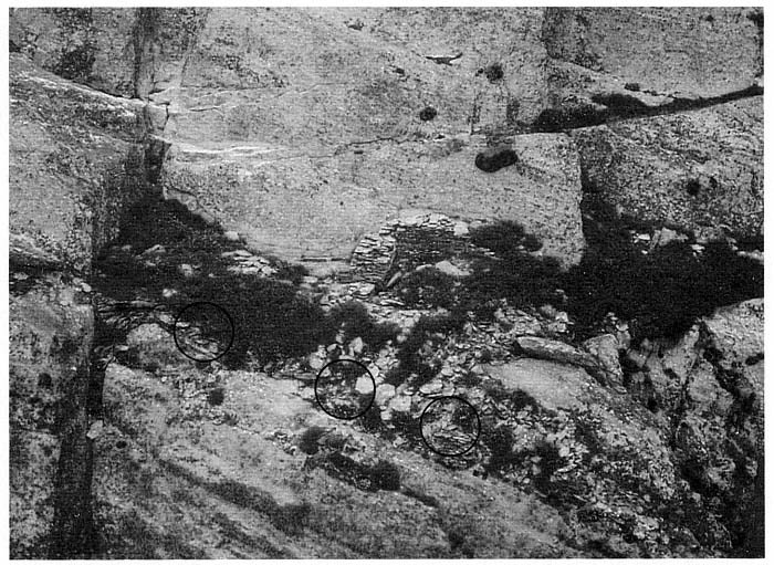
Fig. 38
Skellig Michael, South Peak. Aerial view of the oratory terrace. Circles indicate the masonry fragments of a high retaining wall
that once formed the outer boundary of the terrace. This wall may have risen to the level of the oratory floor in successive
stages, as in Figures 39 and 40, or it may have risen in a straight line all the way up, as shown in the frontispiece.
Photograph by Con Brogan. Courtesy Office of Public Works.
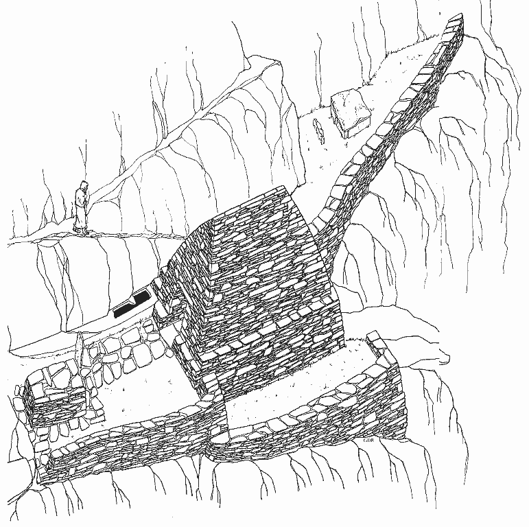
Fig. 39
Skellig Michael, South Peak. Conjectural reconstruction of the oratory terrace by Grellan Rourke, based on the plane-table
survey of 1986.
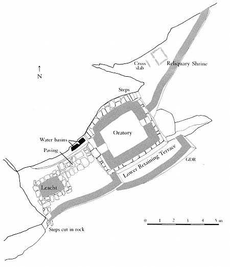
Fig. 40
Skellig Michael, South Peak. Conjectural plan of the oratory terrace by Grellan
Rourke, based on the plane-table survey of 1986.
Retaining walls had to be built on this terrace before any other construction could take place. The remaining fragments of masonry suggest that two walls were necessary on the southern side, related in a complex manner to the layers of sloping bedrock beneath them. The lower, outer wall brought up the level of the terrace to provide a firm foundation for the south wall of the oratory. At the southeastern corner, where the retaining wall turns in toward the eastern extension, it must have been at least 2.5 meters high. Walls built on precariously inclined surfaces were common in the construction on Skellig Michael. Striking parallels are found, for example, in the retaining wall supporting the terrace of the small oratory of the monastery of Skellig Michael (see Fig. 33). Like the South Peak oratory, this sanctuary was built at the upper end of a surface that falls steeply away. To create a level terrace here required the construction of a retaining wall that reached a maximum height of seven meters. This wall has survived, but until repairs were made on it in 1986, its state was so perilous that it threatened momentarily to collapse.
The Eastern Extension of the Oratory Terrace
The eastern extension of the terrace measures roughly 7 by 3 meters (see Figs. 29 and 32). A narrow triangular-shaped space, it slopes steeply to both the south and the east and was originally joined to the principal terrace by a wall.[15] The extension is clearly part of the original plan for the terrace, an integral part of its construction. The labor required to create even a small amount of usable space suggests that this extension served some fundamental, important purpose.
Three stone slabs on the extension furnish a clue to this purpose. Two of them stand at right angles to each other; the third lies somewhat west of the other two (Fig. 41).[16] These upright slabs, or orthostats, were very likely part of a rectangular reliquary shrine constructed of stone slabs. The relics of holy men were venerated in Ireland, as in the rest of the Christian world during this period, although the manner in which the relics were contained and displayed varied according to local custom. In Kerry outdoor reliquary shrines may still be seen on several ecclesiastical sites, such as the island of Illaunloughan, in the Portmagee channel (Fig. 42).[17] Here, as in other known examples, the shrine is constructed of stone slabs set to form an A-shaped structure. Rectangular reliquary shrines formed by upright slabs are unknown. But at the monastery of Skellig Michael orthostats were used to form rectangular frames for the graveyard and for a leacht .
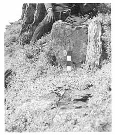
Fig. 41
Skellig Michael, South Peak.
Oratory terrace. The vertical slabs, or
orthostats, on the eastern extension of
the terrace, possibly the remains of
a reliquary shrine.
Photograph by Jenny White Marshall.
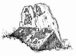
Fig. 42
Island of Illaunloughan in Portmagee channel,
County Kerry. An A-shaped reliquary
shrine formed by slabs.
Drawing by Grellan Rourke.
The creation of a separate place for a reliquary shrine makes sense if we consider the small area of the oratory terrace, but spatial separation may also reflect a symbolic significance. The area surrounding several of the Kerry slab shrines was marked off by small rectangular enclosures, a tangible reminder that the shrines were sacred.
Could a reliquary shrine have been constructed here to venerate a holy monk who had used the South Peak as a place of temporary retreat before the hermitage was built? It is easy to imagine that the arduous struggles of such an extraordinary monk might have inspired the construction of the South Peak hermitage.
[15] The total area of the terrace extension is 10.5 square meters.
[16] The first stone is .45 meter long, .35 meter high, and .15 meter thick; the stone at right angles to it measures .65 meter long, .35 meter high, and .05 meter thick. The third orthostat, located to the west of the other two, is .6 meter long, .25 meter high, and .1 meter thick.
[17] County Kerry has five extant above-ground examples of such shrines: at Caherbarnagh, Illaunloughan, Killabuonia, Killoluaig, and Kilpecan. See Henry, 1957; Thomas, 1971, 142, 143. Fanning, 1981, and O'Kelly, 1958, found, after excavating at Church Island and Reask, the remnants of two others. Thomas comments that four of the extant examples of reliquary shrines in Kerry are set within rectangular enclosures formed by vertically set stone slabs.