Reversion of Irrigated Land to Dryland
Irrigation water will become limited or nonexistent in some areas as groundwater supplies are depleted or become unprofitable to use, and as other sources are partially diverted to other uses. Recreation, energy, municipal, and industrial uses will become increasingly competitive for water supplies. Each of
these uses has definite impacts on the environment. Consequently, it is important that environmental safeguards be provided.
Declining Groundwater Supplies
Overdraft of groundwater in specific areas, particularly in the western United States, is causing concern because of the impact it has on the future of irrigated agriculture. Examples of overdraft areas are the San Joaquin Valley of California, central Arizona, and the Ogallala Aquifer area of the High Plains. Depletion of groundwater is not the only factor causing reversion of irrigated land to dryland in these areas. The cost of energy for pumping groundwater has risen in recent years much faster than the value of crops produced, and has made irrigation unprofitable in some cases. For example, high pumping lifts and sharp increases in prices for natural gas resulted in a sudden drop in irrigated acreage in the Trans-Pecos areas of Texas.
Significant amounts of irrigated cropland in overdraft areas will revert to dryland in future years. Because of its large size and severity of overdraft, particularly in the southern part, the Ogallala Aquifer area has received considerable attention in recent years. Therefore, it seems appropriate to look specifically at this area as a case study. The detailed studies being made on the area may not only lead to more efficient use of the remaining water in the aquifer, but also lead to better utilization of other aquifers as well.
The Ogallala Aquifer Area
A huge underground layer of sand, gravel, and silt saturated with millions of acre-feet of water, the Ogallala Aquifer underlies some 115 million acres of land, largely in six High Plains states. Before World War II, land in the High Plains was primarily used for producing cattle and dryland crops. Irrigation began in the early 1900s, but did not begin to accelerate until the late 1930s. Following World War II, and particularly during the great drought of 1951-56, irrigated acreage expanded rapidly. The combination of a seemingly unlimited supply of excellent quality water, highly fertile soils, newly developed hybrid grain sorghum and other crops, and a favorable climate resulted in tremendous expansion of agricultural production and associated agribusiness. In a matter of a few years, acreage irrigated from the Ogallala Aquifer accounted for more than 25 percent of all irrigated land in the United States. As irrigation accelerated, however, it
became apparent that the aquifer was being mined at a rate far in excess of the rate it was being replenished by the sparse snowmelt and rain.
The Ogallala Aquifer has in recent years become of great concern to the nation and world, but particularly to the people whose livelihood is directly affected. The United States Congress initiated the six-state High Plains Study in 1976 to assess the present and future status of the aquifer. Research results and recommendations from the study were to be reported to the Congress in July 1982.
As a part of the High Plains Study, projections through time were made regarding dryland and irrigated acres by crop, value of agricultural output, input costs, employment, and income for each of the six states under a number of alternative development strategies. The baseline analysis was designed to project, from the base year 1977 to 2020, possible changes in the pattern of irrigated and dryland production and water use, by state, under the general assumptions that no new purposeful public action would be initiated to restrict or otherwise regulate irrigation water use in the area. Therefore, the baseline reflects future changes in acreages if no new voluntary or regulatory water management schemes are implemented and if no new water sources are developed. However, interactions between crop yields, water use, improved technology, declining well yields and rising pumping costs, competing crops and cultural practices were considered in the analysis. Mapp (1981) summarized the findings of the analysis and discussed some of the more important of the many assumptions required to perform the study.[5] Space does not allow full discussion of the assumptions, but we report a portion of the results here because of the important environmental implications of the projected changes.
Results from the High Plains Study
Data presented in Figure 15.1 for the High Plains region project a continued increase in irrigated acreage. There is a slight decrease between 1985 and 1990 which results from anticipated deregulation of natural gas prices. After 1990, however, increases in crop yields and real product prices outstrip further increases in energy prices, and irrigated acreage continues to expand. It is especially significant to note in Figure 15.1 that the amount of irrigation water pumped from the aquifer decreases markedly through the 1980s even though irrigated acreage is continuing to increase. After 1990, the water pumped
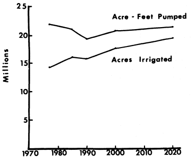
Figure 15.1
Projected Acres Irrigated and Acre-Feet Pumped
for the High Plains Ogallala Aquifer Area
Source: Adapted from H.P. Mapp, "The Six-State
Ogallala Aquifer Area Study: Baseline Results
for the Agricultural Sector," 1981.
increases somewhat in proportion to the increase in irrigated acreage. In 1977 about 1.5 acre-feet of irrigation water were pumped for each acre of land irrigated in the region; this is projected to decrease to 1.3 by 1985 and 1.2 by 1990, and then remain fairly constant. Water use will vary greatly between states, however, because of availability. For example, usage in Texas, where underground water supplies are becoming quite limited, is assumed to drop from 1.38 acre-feet per acre in 1977 to about 0.65 acre-feet per acre in 2020. This decreased usage in applied water for each acre of irrigated land is expected to result in marked changes in crops grown, irrigation application methods, and cultural practices.
Significant differences in water supply exist among the High Plains states that overlie the Ogallala Aquifer. The aquifer contains an estimated 21.8 billion acre-feet of water, which if evenly
distributed would be about 190 acre-feet of water under each acre of land. Texas, Oklahoma, and New Mexico, however, contain approximately 30 percent of the aquifer area but only about 15 percent of the water, whereas Nebraska contains 36 percent of the aquifer area but 64 percent of the volume.
The baseline projections for the six states studied are shown in Figure 15.2. Nebraska is expected to continue to rapidly expand its irrigated acreage while other states show fairly sharp decreases, or remain constant. The projections for Nebraska also show that irrigated acreage will expand much more than dryland acreage will decrease. Consequently, large acreages of land presently used for purposes other than cropland will be brought under cultivation, much of it undoubtedly in sandy areas presently in grass. The large expansion of irrigated land in these areas, particularly on sandy soils, will present pollution potentials because of the marked increase in fertilizer and pesticide usage that will be associated with intensive crop production. Natural recharge of the aquifer is higher in this area than any other area in the region, and with added irrigation, the possibilities of leaching nutrients and salts into the aquifer will be greater. Good management systems which address pollution hazards will be needed.
Projections for Kansas and Texas show substantial decreases in irrigated acreage and corresponding increases in dryland acreage. The dryland acreage in Kansas is projected to increase even more than irrigated acreage will decline, which again indicates that total cropland acreage will have to come from somewhat marginal lands with perhaps higher than average erosion potential.
The data for Colorado and New Mexico (Figure 15.2), and Colorado in particular, suggest that irrigated acreage will decrease without an accompanying increase in dryland acreage. Therefore, much of the irrigated land in these areas is expected to go out of cultivation. In some areas within other states this will also happen; in many cases these will be sandy areas that were not in cropland until center-pivot sprinkler irrigation systems were installed. Much of this land will not be suitable for dryland farming, and unless special care is given, serious environmental consequences could be encountered. Wind erosion will be a major problem and revegetation of the areas will be very difficult, unless it is done before irrigation is stopped. A bill was introduced in the Nebraska legislature that would have required center-pivot irrigators to revegetate wind erosion-prone
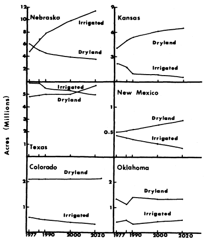
Figure 15.2
Projected Acreage of Irrigated and Dryland Cropland
in Six States of the Ogallala Aquifer Area.
Source: Mapp, 1981.
land before irrigation systems could be removed. Although it is unlikely a bill of such nature will be passed, its introduction recognized the potential environmental hazard of irrigated lands reverting to dryland.
In areas where cropland was primarily dryland-farmed prior to the time it was irrigated, the land can generally be returned to its former use without serious environmental impacts. The production from dryland areas will be extremely variable, ranging from fairly high yields in above average rainfall years to very low yields or even crop failures in drought years. There is very little likelihood, however, that widespread dust storms such as those that occurred during the "Dirty Thirties" will reoccur. For example, recently improved cropping methods and cultural practices result in more efficient storage of soil water during fallow periods. Large farming equipment developments allow more timely and effective cultivation. Better crop varieties are less prone to complete failure. Other technologies are also emerging that, when coupled together into integrated farming systems, are very effective in controlling erosion. This is not to say that there will not be localized areas where environmental hazards are acute, but the region as a whole is not expected to be seriously damaged.
The conversion of irrigated land to dryland in the High Plains states will result from either a declining supply of water, the inability to realize enough profit from irrigated farming to pay for the associated energy costs, or a combination of the two. If water availability is the primary constraint, the conversion of irrigated land to dryland will be gradual and will generally move from fully-irrigated to limited-irrigated to dryland. Limited irrigation will involve only one or two irrigations, or perhaps only preplant irrigations during the winter to reduce evaporation losses. This orderly conversion to dryland presents little environmental hazard.
The most serious environmental threat would result from a situation in which energy costs, or some other economic condition, causes a sudden abandonment of large areas of irrigated land. The most environmentally-critical areas, as already mentioned, would probably be sandy areas presently irrigated with center-pivot systems. These lands were broken out of native range due to economic incentives and generally have low dryland production potential. Unless some orderly plan is developed to revegetate these lands with permanent cover, serious environmental hazards will result. The most serious hazard, of course,
would be wind erosion. Figure 15.3 shows the principal soils overlying the Ogallala Aquifer. The sandy soils that present the greatest environmental hazard are illustrated by crosshatched areas. The double crosshatched soil areas represent the most severe environmental hazard potential. Irrigated acreage has expanded substantially in some sandy areas in recent years. It is evident that if irrigated acreage expands further, as projected in the High Plains Study (Figure 15.2), much of the increase will likely occur on soils having a severe environmental hazard potential.
Similar problems occurred during the 1930s when many farmers abandoned sandyland farms near Dalhart, Texas. To alleviate the vast erosion from the area, the federal government bought the farms and charged the USDA Soil Conservation Service with the task of revegetating the land. These lands now are part of the National Grasslands managed by the U.S. Forest Service. Similar projects occurred in other parts of the Great Plains.
The discussion above points out some of the complexities of the High Plains region. It is clear that there will be a gradual decrease in irrigated acres for all states in the region except for Nebraska, where the water-to-land ratio is high. The decline in acres irrigated will likely be much slower than the actual decline in acre-feet pumped from the aquifer. Improved irrigation techniques and equipment are being developed which allow more efficient use and distribution of irrigation water. Also, cropping systems are being developed that emphasize utilizing limited amounts of irrigation water; fully irrigated systems of the past were designed for maximum yields rather than efficient use of water. The primary benefit of limited irrigation in this region is that it allows for much more efficient use of the natural precipitation. The average amount of irrigation water pumped for each acre of irrigated land in the region is about 20 inches. The addition of just 8 inches of irrigation water to the natural precipitation of the region could have a very beneficial effect on crop yields and would help stabilize production and reduce risks.
Groundwater pumped from other major aquifers in the western United States will also likely decrease in future years as a result of overdraft or uneconomic conditions. Unlike the High Plains region, much of the irrigated land in other areas of the western United States is in arid areas. In general, 14 inches or more of annual rainfall are required to sustain dryland agriculture. However, water harvesting technologies and more drought tolerant crop varieties are emerging that may extend dryland crop production in areas previously considered too dry.
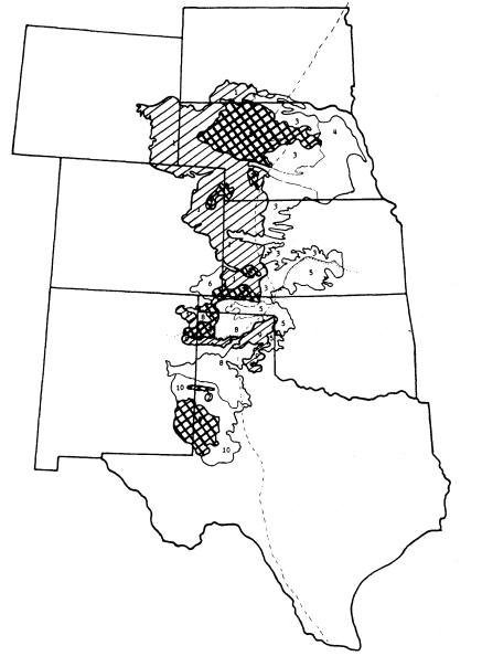
Figure 15.3
Principal Soils Overlying the High Plains Ogallala Aquifer
Areas of sandy loam and loam soils are cross-hatched, and sandy soils are
double cross-hatched. Soils in other areas are primarily loams and clay loams.
Source: Fred Pringle and Gerald Ledyard, USDA Soil Conservation Service.