Facies Analysis and Geological Correlations
Fastovsky (1987) has published a detailed facies analysis of vertebrate-bearing strata spanning the K-T transition in parts of eastern Montana. General classes of lithofacies
|
Figure 3
Comparison of terminology employed in this and other analyses of lithofacies in the upper
Hell Creek and lower Tullock formations of eastern Montana.
at Bug Creek (Fastovsky and Dott, 1986; Fastovsky, 1987), which is only 1 km north of the McGuire Creek study area, can be recognized and employed at McGuire Creek (see Figure 3). Additions or modification of these facies based on strata at McGuire Creek are given below when necessary. Two additional lithofacies (Facies B and G) were recognized at McGuire Creek and are described in detail.
Facies A
This facies is lithologically similar in part to the Siltstone Facies of Fastovsky, 1987, and Facies B of Fastovsky and Dott, 1986.
Description : Facies A is composed primarily of very thick to medium interbeds of green, gray, and purple, laminated to massive, siltstones and mudstones. Thick (up to 70 cm) lenticular sandstones that fine upward to siltstone or mudstone are also present but rare. Isolated and associated remains of larger-bodied vertebrates, primarily dinosaurs, are present. These occurrences usually are limited to isolated dinosaurian skeletal elements that are widely separated both geographically and stratigraphically. However, occurrences of more complete dinosaurian material were observed. The eroded and scattered remains of a partial ceratopsian skull are present in Section D (Plate 2). Mammalian remains were not recovered from this facies.
Interpretation : Facies A includes floodplain deposits that underwent soil development (Fastovsky, 1987; Fastovsky and McSweeney, 1987). Vertebrate fossils probably represent animal remains that were lying on the floodplain surface or in localized depressions that were subsequently buried by suspended sediment during flooding events. Fossils found in this depositional setting are unlikely to have been reworked from older strata, especially in the case of the ceratopsian skull cited above.
The absence of mammalian and other small-bodied vertebrate remains may be a reflection of the size of skeletal elements. Small bones have high surface-to-volume ratios and would be more readily destroyed during soil formation (Retallack, 1984).
Facies B
Description : Thin to medium interbeds of dark brown, brown, and gray sandstone, siltstone, and mudstone are present. Lenticular, fine-grained sandstones comprise 30-40% of this facies. Sandstone lenses are usually 15-20 cm thick and 15-20 m wide, and the largest observed is 1 m thick and 30 m wide. Sandstones also occur as thin laminated beds interbedded with siltstones and mudstones. Internally, sandstones exhibit ripple and small-scale tangential, planar, and trough (rare) cross-stratification sets. Siltstones and mudstones are laminated or massive, and all lithologies commonly have organic debris and plant macrofossils on laminae. Root casts are present but are rare. Siltstones and mudstones are more laterally continuous than sandstones, and usually can be traced laterally for over 25 m. Facies B fines upward and is overlain by Facies C.
The best exposures of Facies B near Section V (Plates 1, 2) indicate a channel-form morphology with steep bank margins which are deeply entrenched into Facies A beds. The base of Facies B is not exposed here, but a minimum of 6 m of relief is developed on this erosion surface, which dips 25-30 degrees to the east. The orientation of Facies B beds adjacent to this surface conforms to the eastward slope but levels out when traced toward the axis of the channel. This Facies B and Facies A contact trends 165 degrees and can be traced for 1.5 km to the southeast (Plate 1). Exposures of Facies B adjacent to Section V are over 150 m wide. East of these exposures are poorly exposed cross-stratified sandstones (Plate 1).
Articulated and associated remains of aquatic vertebrates including turtles, crocodiles, and champsosaurs are present in Facies B. Mammal and dinosaur remains were not recovered from this facies.
Interpretation : Facies B represents channels that were abandoned and slowly filled with suspended silt and mud. Lenses of cross-stratified sand indicate periodic influx of sand as channelized traction load during flooding events. The abundance of plant fossils but rarity of root traces suggests that the abandoned channel usually contained standing water. The presence of aquatic vertebrates supports this interpretation. Cross-stratified sandstones lateral (east) of Facies B outcrops (Section V) probably represent previously deposited thalweg channel-fill material.
Facies C
Facies C is lithologically similar to the Facies of Organic Accumulation of Fastovsky, 1987, and Facies D of Fastovsky and Dott, 1986.
Description : Facies C is composed of very thick to medium-bedded black to purple lignite and carbonaceous shale, containing 1-10 cm thick mud partings. Discontinuous or laterally persistent, 2-5 cm thick volcanic ash layers are present in both the McGuire Creek Lignite (MCZ) and Tonstein Lignite (TL). The MCZ and TL each contain a particularly persistent volcanic ash layer whose presence was useful for mapping across disjunct exposures. The MCZ is locally overlain by a 20-50 cm thick, massive, black to dark gray mudstone which is devoid of plant macrofossils and roots. This mudstone is useful for correlation of the MCZ between isolated exposures. Amber granules are abundant in the TL. Vertebrate remains were not recovered from Facies C.
Interpretation : Facies C represents the development of widespread coal-swamp deposits in the McGuire Creek area. Extensive coal-swamp development is evident because the MCZ and TL are laterally traceable over more than 20 and 4 sq. km, respectively (Plate 1). The extensive development of lignites in the McGuire Creek study area is noteworthy because coal horizons at or below the formation boundary can be extremely localized elsewhere (Archibald, 1982; Fastovsky and Dott, 1986; Fastovsky, 1987).
It appears that the TL, and possibly the MCZ, may have significant utility as correlation tools in biostratigraphic studies because they are evidently present in regions north and west of the McGuire Creek study area. A Hell Creek Formation lignite, the Null Coal, mapped within the Bug Creek drainage by Smit et al. (1987) and Rigby and Rigby (1990), almost certainly is equivalent to the TL based on elevation, stratigraphic position, and general lithologic similarity. However, the absence of ash layers in the Null Coal precludes definite correlation (NW quadrant of Section 16, Plate 1, and directly below the Bug Creek Anthills channel fill, NW quadrant of Section 9, T 22 N, R 43 E).
A coal in the upper Hell Creek Formation containing one or two ash layers and amber is exposed at Jawbone Coulee and Thomas Ranch, 5 and 15 km west of the McGuire Creek study area, respectively. The Jawbone Coulee lignite has two ash layers and amber, and closely parallels the TL in general stratigraphic position, lithologic character, and position of ashes within the coal (Section 13, T 22 N, R 42 E). In the opinion of Dr. Carol Hotton (pers. comm., 1989), the TL may also be equivalent to the Tonstein Coal at the Thomas Ranch locality (Hotton, 1988; Section 14, T 22 N, R 41 E) based on approximate stratigraphic position, presence of an ash layer, and abundant amber granules.
The MCZ is difficult to trace into the northern part of the study area, and correlations become questionable (Plate 1). Correlation between lignites is especially difficult to the northwest (Section HH) because of discontinuous exposures and thinning of coals. It appears that the MCZ and upper "Z" coal of the lower Bug Creek drainage (not including Russell Basin) are two different units (Section OO, Plate 4). However, mapping north of Section DD (Plate 4) indicates that the MCZ is traceable northward into the headwaters of the Bug Creek drainage and is equivalent to the uppermost lignite of the "Z" complex at Russell Basin (upper "Z" of Smit et al., 1987 and Rigby and Rigby, 1990). It appears that the upper "Z" and MCZ (Section OO) are two units of a series of thin lignites that comprise the upper "Z" complex of Russell Basin.
Facies D
Facies D is lithologically similar to the Variegated Facies of Fastovsky, 1987; Facies E of Fastovsky and Dott, 1986; and the "variegated" beds of Archibald, 1982.
Description : Facies D is composed of thin to medium interbeds of yellow-brown or gray laminated siltstone and mudstone. Thin individual beds can be traced for hundreds of meters laterally in continuous exposures. Facies D, as a whole, is laterally traceable for over 25 sq. km in the McGuire Creek area. Facies D contains isolated occurrences of articulated elements of turtles and champsosaurs.
Interpretation : Facies D represents extensive pond deposits (Fastovsky, 1987).
Facies E
Facies E is lithologically similar to the Facies of Epsilon Cross-Stratification of Fastovsky, 1987, and Facies C of Fastovsky and Dott, 1986.
Description : Facies E is composed of 3-20 m thick gray sandstones in elongate sheet morphologies whose base is scoured into Facies A or another Facies E unit (Plate 3). Basal scours are commonly flat but can also exhibit over 5 m of relief (Little Roundtop Channel, Sections Q and 861, Plate 3). Weakly to well-defined inclined heterolithic stratification (IHS) (following Thomas et al., 1987, this term replaces "epsilon cross-stratification") sets are present that exceed 15 m in thickness and exhibit dips of 10-20 degrees. IHS is defined by alternating beds of sandstone, siltstone, and mudstone. It extends down to the basal scour in some cases (Little Roundtop Channel, Plate 3), but in others (Second Level Channel, Plates 3 and 4) the basal 1-7 m is composed of thick, vertically stacked sets of trough cross-stratified sandstone (similar to Facies F) which fine upward in both grain size and scale of sedimentary structures before interfingering with IHS (Sections 861, Q, R, Plate 3; Section T, Plate 2; Sections R, 871, Plate 4; Sections O, P, Plate 4). Paleocurrents of trough cross-strata are approximately perpendicular to IHS surfaces (Figure 4). Complete Facies E sequences fine up to siltstone and mudstone and are overlain by Facies C, or Facies G and C.
Poorly sorted, clast-to matrix-supported lag concentrations of clayball conglomerate, carbonized plant debris, fossil wood, and vertebrate fossils are commonly present at the base of Facies E channels. Basal lags consist of discontinuous 30-100 cm thick lenses of poorly sorted, clast-supported, pebble-cobble conglomerates composed of rounded mudstone and siltstone clasts. Conglomerates also occur as lenses within or underlying trough cross-bedded, medium to fine grained sandstone. Fragments and impressions of carbonized plant debris are abundant, while fossilized wood is rare. Localized depressions in channel floors are commonly filled with conglomerates containing rich concentrations of microvertebrate fossils. These fossil remains usually consist of isolated teeth and disarticulated elements (complete elements are rare) of aquatic and terrestrial vertebrates which have undergone hydraulic transport and sorting. Fossils are commonly fragmentary and abraded, but many pristine bones and teeth were also recovered. Fossils are intermixed with pebble-sized intraclasts that apparently have similar settling velocities (this is not true for larger fossils). Isolated teeth of mammals and dinosaurs are common, and fragments of shed ceratopsian teeth com-
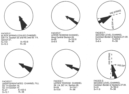
Figure 4
Trough cross-bedding orientations measured in the upper Hell Creek Formation at McGuire
Creek. Data presented are grouped by mapped channel fill except where noted N= number of
measurements; X= vector mean in degrees; S= circular dispersion in degrees; R= vector
magnitude. See Plate 1 for location of channel fills measured.
prise the great majority of dinosaurian dental remains. Mammal jaws are uncommon, and mammalian maxillary fragments are rare. In comparison to the number of dental remains at any one site, mammalian postcranial elements are under represented and usually consist of dense elements such as phalanges, carpals, tarsals, and distal or proximal fragments of other limb bones. Vertebrate fossils were not found on IHS surfaces or immediately above the base of Facies E sequences.
Facies E lag concentrations which produce Bug Creek vertebrate assemblages are the Brown-Grey, Second Level, and Little Roundtop channel fills. The Z-Line Channel does not cut deeply into Facies A beds and yields a Puercan assemblage. Well-preserved teeth and many heavily abraded fragments of dinosaur bone are present at locality V87072 (Brown-Grey Channel).
Interpretation : Facies E represents laterally accreted channel-fill deposits. IHS is interpreted as lateral accretion surfaces of point-bar deposits (Fastovsky, 1987), while thick trough cross-strata in the lower region of Facies E channel fills represent vertically accreted thalweg sandstones (Mossup and Flach, 1983). Facies E channels were
entrenched into pre-existing Facies A units. Superposed Facies E fills (Little Roundtop and Second Level channels, Plates 3 and 4) indicate that multiple channel cutting and filling events also occurred. Therefore, considerable reworking of pre-existing strata and their entombed vertebrate remains probably occurred.
Facies F
Facies F is lithologically similar to the Cross-Stratified Sandstone Facies of Fastovsky, 1987, and Facies A of Fastovsky and Dott, 1986.
Description : Facies F is composed of 10-20 m thick, multi-storied, gray sand bodies which are commonly overlain by Facies G and C, and usually sharply bounded below by Facies A. Facies F units truncate Facies E channels and also Facies D and C deposits above the MCZ (Plates 2-4). Relief on these erosion surfaces exceeds 15 m (Sections II and 811 or Sections O, P, 856, and 855, Plate 4; Sections H-B, Plate 2).
Individual stories are lenticular, have a sharp undulatory base, and are about 2-10 m thick and 10-50 m wide. Successive stories are commonly incised into preceding channel-fill cycles, and several erosion events can be seen in good exposures (for example, Section H, Plate 2). Limited three-dimensional exposure of some stories shows that they have channel-form geometries with subparallel axes. Paleocurrent data indicates a south-southeast flow direction with a markedly unidirectional trend (Figure 4). Mapped Facies F sand bodies exhibit widths of approximately 0.5 km perpendicular to paleocurrent means (Plate 1).
Relatively complete stories exhibit a decrease in scale of sedimentary structures from very thick or thick sets of trough and planar cross-stratification to medium or thin sets of trough, planar, and ripple cross-stratification, overlain by siltstone. Sediments within most stories fine upward from medium grained sandstone with minor amounts of mudstone pebble conglomerate at the base to organic rich fine-grained sandstone or siltstone at the top.
Basal scours of Facies F sand bodies commonly exhibit localized lag concentrations of poorly sorted, clast- and matrix-supported, clayball conglomerates which contain fossil wood, carbonized plant debris, and vertebrate fossils (see Facies E for a general description of the depositional setting of these vertebrate remains). In Facies F, vertebrate fossil remains were rarely found above the basal lag of the lowest story.
Facies F lag concentrations which produce Bug Creek assemblages are the Black Spring Coulee and possibly the Upper Tedrow and "Lower Tedrow" channel fills. Jacks Channel produces a Puercan vertebrate assemblage. Vertebrate fossil occurrences in lag concentrations usually consist of isolated elements, but abundant well-preserved dinosaur material is present at Black Spring Coulee (V87030; see the following chapter on Reworking of Fossils for discussion).
Interpretation : Facies F multi-storied sand bodies were probably developed through vertical aggradation in laterally stable channels of low sinuosity. The subparallel channel-form geometries of each story, low divergence of paleocurrents, and absence of lateral accretion features such as IHS support this interpretation. Upward decrease in grain size and scale of sedimentary structures within each story records waning paleoflow strength between flood events. Multiple scour and fill events occurred within channels, as evidenced by entrenchment of superposed stories. The deep entrenchment of Facies F channels into pre-existing sediments suggests that considerable reworking of fossils occurred.
Other channel fills, not assignable to a channel facies because of poor exposures, contain important occurrences of vertebrate fossils. The K-Mark Channel yields a Lancian vertebrate assemblage. Matt's Dino Quarry Channel produces disarticulated but closely associated hadrosaur skeletal elements and a complete turtle shell. The Shiprock and Up-Up-the-Creek sites yield Bug Creek assemblages.
Facies G
Description : Facies G is composed of tabular interbeds of thin to thick brown, gray, and greenish-gray sandstone, siltstone, and mudstone. Sandstones comprise 20-30% of this facies and are commonly laminated, but also exhibit ripple and small scale planar cross-stratification. Sandstones also occur as elongate lenses up to 10 cm thick within siltstones. Siltstones and mudstones are laminated and contain organic debris and well-preserved plant macrofossils on laminae. Complete leaves are extremely abundant locally in all laminated lithologies, and large palm fronds were observed. Fossilized in situ tree stumps are present at sections B and H (Plate 2). Root casts are present, but are not common. Individual sandstone, siltstone, and mudstone units are commonly traceable over tens of meters.
Thin black carbonaceous shales-mudstones composed of fissile mats of laminated plant debris are also present, and are traceable for hundreds of meters in continuous exposures. Articulated and associated remains of turtles, champsosaurs, and crocodiles are abundant in carbonaceous shales-mudstones. Neither mammals nor dinosaurs were recovered from this facies.
Facies G overlies floodplain facies (Facies A, east part of Plate 2) and overlies and interfingers with channel facies (Facies E and F, Plates 2-4). Facies G can be a continuum with Facies, A, E, and F and boundary recognition must be arbitrarily determined in many cases. However, with respect to Facies G and A, they differ in color, and Facies G beds are more tabular and laterally continuous. Also, Facies G sediments contain well-preserved plant macrofossils (including in situ tree stumps) and internal bedding features (laminations and ripples).
Interpretation : Facies G represents floodplain deposits developed in association with channel facies. These floodplain deposits comprise the culmination of fining upward sequences of channel facies (E and F), or the lateral floodbasin deposits of these channels. Extensive but short-lived swamps were developed on floodplains, as evidenced by the thin but laterally continuous carbonaceous shales containing abundant aquatic vertebrates. Cross-stratified sandstones probably represent minor crevasse-splay development on the floodplains. The presence of tree stumps, abundant plant macrofossils, and root traces indicates that these floodplains were probably heavily vegetated. However, paleosol development was generally not as advanced as in Facies A because delicate sedimentary structures such as laminations and whole-leaf plant fossils are extremely abundant and well preserved.