Proven (Drilled) Geothermal Fields
Meager Mountain
Meager Mountain in British Columbia, Canada, with a volume of 70 km3 and a cone height of 1500 m, comprises nine overlapping andesitic and dacitic volcanic assemblages that range from late Pliocene to 2440 years BP (Souther, 1985). Its multiple vents are aligned along a north-south trend. The volcano overlies a high-relief surface of older plutonic and metamorphic rocks (late Mesozoic to early Tertiary Coast Plutonic complex and late Miocene epizonal plutons). The older rocks consist of andesitic flows and volcanic breccias, and the younger rocks are dacitic flows and domes, ashfall deposits, and ignimbrites.
Warm springs of ~60°C issue from faults within the basement rocks at the base of the volcano. Much of the anomaly is masked by near-surface meteoritic water. Fifteen
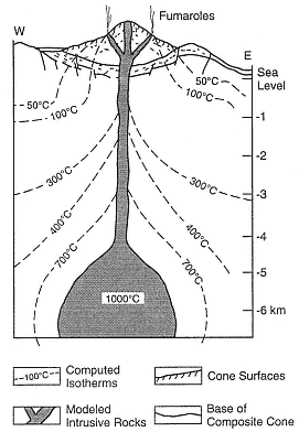
Fig. 7.20
This computed temperature profile of
Hakone volcano in Japan was created for a
composite cone located within a small caldera.
(Adapted from Iriyama and Oki, 1978.)
coreholes were drilled on the northern and southern flanks of the volcano (Adams et al ., 1985). Argillic alteration of the basement rocks was detected on the northern slope, but no hydrothermal fluids were found. Below the southern slopes, a plume of hot water (~200°C) rises along north-south-trending faults and along fractures within basement rocks; 233 to 264°C fluids were encountered at depths of 3 to 3.5 km in fractured plutonic rocks.
The hydrothermal resource is fracture-dominated and follows the Meager Creek fault zone, where the host rocks have low permeability and porosity. It is likely that the fluids are heated by subvolcanic intrusive rocks, but the amount of thermal energy contributed by cooling dikes and plugs is not known. The system may be related to deep circulation of fluids along the Meager Creek fault zone. Souther (1985) reported on two drilled reservoirs; the shallow, low-temperature (<140°C) reservoir has been clogged with authigenic minerals and forms a barrier for deeper, hotter fluids; the deeper reservoir, in fractured basement rocks, has temperatures >200°C.
Momotombo
The Nicaraguan Depression in Central America, which lies parallel to a northwest-southeast-trending plate boundary, encompasses most of the Quaternary-to-historical volcanic fields of Nicaragua. Momotombo Volcano, located on the northwestern shore of Lago de Managua, is a 1258-m-high symmetrical cone, with a volume of 12 km3 (Fig. 7.21 and cover photo). Momotombo is a submature composite cone within a northwest-southeast-trending graben and adjacent to a 4-km-diameter caldera. The somma ridge of an undated but older cone is located ~900 m above the base of Momotombo. The youngest rocks here are andesitic lavas that were erupted in 1905 AD (Mooser et al ., 1958).
Surface geothermal manifestations include active fumaroles in the summit crater and hydrothermally altered ground over a 4 km2 area along the southern slope of the volcano. This altered ground follows hydrothermally active, northwest-trending fractures (Figs. 7.21 and 7.22). Drillholes up to several kilometers deep were sited in interbedded andesitic lavas, welded tuffs and ashes, basaltic lavas and ashes, and dacitic lava; the most common rock type is andesitic lithic tuff (Moore et al ., 1982). Some of the rocks have been interpreted as phreatomagmatic—which is certainly possible because Momotombo sits on the shore of Lake Managua.
Maps of the alteration aureoles suggest structural control and fracture permeability within the reservoir and have provided an excellent basis for siting both exploration and production drillholes. Most of the wells with high permeability are within 100 m of a high-angle reverse fault and a right-lateral strike-slip fault. Some of the fractures show signs of secondary brecciation and may have formed by hydraulic fracturing (Moore et al ., 1982). Drilling has determined that there is good correspondence between surface and subsurface structure. The highest temperatures (225°C) are within a lens-shaped reservoir at depths of 244 to 366 m. In 1979, six production wells supported a 30-MWe plant; Rowley (1982) estimated field capacity is 800 MWe , although that is an optimistic estimate.
Ahuachapán
The Ahuachapán geothermal field in El Salvador Central America is associated with the Laguna Verde volcanic complex, which consists of north-northeast-trending lines of craters and small cones. The 500- to 600-m-diameter craters at the summit of these composite cones may be phreatomagmatic. These volcanoes are composed of interbedded andesitic tuffs, lavas, and agglomerates that range from Pliocene to Holocene (a very general estimate by Romagnoli et al ., 1976).
Also associated with the Laguna Verde volcanic complex and north-northwest-trending
normal faults are two major hot spring areas and three fumarolic fields with temperatures as high as 123°C. The geothermal wells located in this area are producing fluids from interbedded pyroclastic rocks and lavas with temperatures of 228°C at a depth of 900 m. Production wells have been drilled to average depths of ~800 m. The fumaroles, hot springs, and most of the drillholes are located near intersections between north-northwest-trending faults and east-northeast-trending faults. Two 30-MWe - and one 35-MWe -capacity electrical generating plants were completed by 1987.
Ohnuma
The Ohnuma geothermal field of Japan is located on the flank of Hachimantai Volcano, an 800-m-high, flat-topped lava shield composed of mafic andesitic lava flows (Kuno, 1962). This immature composite cone, where lavas range from 0.5 to 1.0 Ma, has a volume of ~13 km3 .
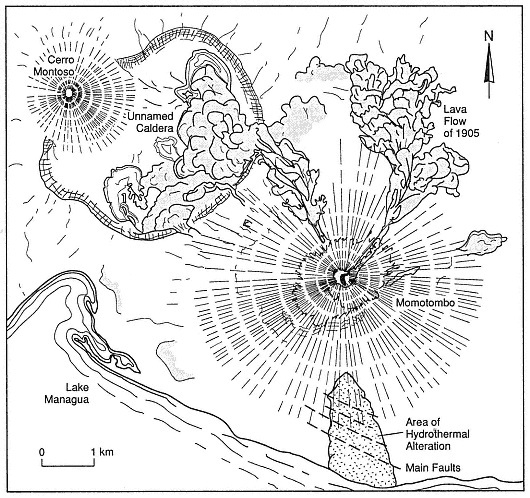
Fig. 7.21
Map of Momotombo Volcano in Nicaragua shows the main faults and
areas of alteration, which are marked with a stippled pattern.
(Adapted from Mooser et al ., 1958; Moore et al ., 1982.)
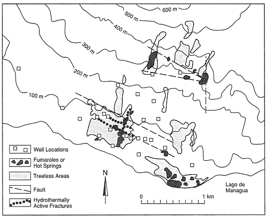
Fig. 7.22
The Momotombo geothermal field is located on the southern slopes of
Momotombo volcano and on the edge of Lake Managua.
(Adapted from Moore et al., 1982.)
Thermal areas marked by geysers, mudpots, fumaroles, and hot springs cover 5 km2 . The hydrothermal system may not be directly related to the composite cone, but rather to an older caldera and a north-south-trending graben. The reservoir is located within highly fractured dacitic and andesitic lavas and interbedded pyroclastic rocks (Nakamura et al ., 1981; Kimbara, 1986). Production wells have been drilled to depths of 1.3 to 1.7 km.
Matsukawa
The Matsukawa geothermal area of Japan is located between the Maru Mori and Iwate volcanoes. The area's largest cone is 800 m high and the volcanic complex has an approximate volume of 45 km3 . This complex includes composite cones, a dome, and a 1.8- by 3.0-km-diameter summit caldera. Kuno (1962) reported that its lava flows and volcanic breccias consist of augite-hypersthene andesite (in the older part of the cone) and olivine andesite (in the main cone). The summit crater contains fumaroles and small areas of acid alteration. This complex is believed to be of Pleistocene and Holocene age.
The geothermal area is marked by a 0.5- to 1- by 7.0-km east-northeast-trending zone of argillization, silicification, and hot springs. The zone overlies a geothermal reservoir at a depth of 1.0 to 1.2 km in fractured welded tuff and shale; there is a caprock of welded tuff (Nakamura et al ., 1981; Kimbara, 1986).
Because the geothermal system is located on the rim of a caldera, it may be only partly related to the cone.
Tamagawa Spa
The Tamagawa Spa of Japan is a group of acidic hot springs located at the western foot of Mount Yake (Yakeyama). Mount Yake is a 750-m-high mature composite cone with a volume of 10 km3 (Kuno, 1962); the cone's 600-m-diameter summit crater contains a small dome and four small explosion craters. There is also a parasitic dome on the southern flank of the main cone. Mount Yake is composed of mostly hypersthene-olivine andesitic lava flows and pyroclastic rocks, and the domes are andesitic. The most recent eruption products are Holocene. This cone may overlie the rim of an older caldera and the hydrothermal system could be associated with that caldera.
The geothermal area (spa) comprises lines of fumaroles, hot springs, and deposits of silica sinter, all of which are oriented east-west and north-south. The springs have temperatures up to 98°C and pHs of <1.2. The main geothermal area is located in a depression that has been interpreted as both a phreatic crater and a landslide. The reservoir is located within fractured Tertiary-age tuff, shale, and andesitic lava (Nakamura et al ., 1981).
Bouillante
The volcanoes of Guadeloupe, in the Lesser Antilles, include composite cones and domes and are located along the north-south-trending spine of Basse-Terre (the high, volcanic portion of the island). Soufrière de Guadeloupe is a dacitic dome with a summit 1467 m above sea level and is the site of historic eruptions that included explosive phreatic activity 1976 to 1977 AD. Eruptions of Soufrière de Guadeloupe have produced phreatic deposits, pyroclastic fall deposits, ignimbrites (mostly nonwelded), andesitic lavas, laharic breccias, and dacite domes. Vatin-Perignon et al . (1984) documented ages from 0.3 Ma to the present.
The summit region of Soufrière, site of the youngest cones and domes, is cut by northwest- and northeast-trending faults, along which there are surface manifestations of the geothermal system such as summit fumaroles and large areas of acid alteration. Hot springs are located around the base of the most recent dacite dome, which was recently modified by phreatic eruptions (Heiken et al ., 1980).
A commercially developed hydrothermal system is located on the island's west coast along a northwest-trending fault and a line of small cones that extends from Soufrière de Guadeloupe down to the coastline (Fig. 7.23). At Bouillante, there are areas of hydrothermal alteration and silicification as well as a 98°C spring. The geothermal reservoir, located within Tertiary tuffs and andesitic lava flows, has both fault (fracture) and formation permeability. Temperatures at a depth of 500 m are >240°C (Demians et al ., 1972; Vatin-Perignon et al ., 1984). Epidote appears in rocks below 100 to 300 m.
Kawah Kamodjang
The fumarole field of Kawah Kamodjang in Indonesia is located in western Java, where its specific association with a composite cone or cones is not clear. The nearby volcanoes of Rakutak, Chihara, Danou, Pangkaban, Gandapura, Masagit, and Guntur are part of a 15-km-long, 4- to 5-km-wide volcanic chain, which is parallel to a graben that trends west-southwest and east-northeast; most faults strike N60°E. The highest cones have elevations of ~1500 m and are composed of well-bedded, massive pyroclastic rocks that are interbedded with thick andesitic flows (Neuman van Padang, 1951; Robert et al ., 1983). Robert et al . (1983) postulated that the geothermal area may be located within a small (2-km-diameter, 500-m-deep), poorly defined caldera.
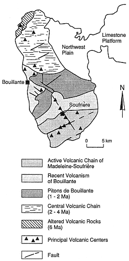
Fig. 7.23
Sketch geologic map of the western part of the
island of Guadeloupe (Basse-Terre) in the
Lesser Antilles. The Bouillante geothermal
area is located along northwest-trending
faults that extend downslope from the active
volcanic chain of Madeleine-Soufrière.
(Adapted from Gérard et al. 1981.)
Within the 2-km-wide depression is a 1200-m-long, 100- to 700-m-wide zone of fumaroles, mudpots, phreatic craters, and hot springs with temperatures of 80 to 105°C. Six production wells supplying a 30-MWe generator were drilled in small grabens within the larger graben. The drilled reservoir is located within hydrothermally altered, fractured tuffs and lavas, where temperatures reach 200 to 230°C, at a depth of 900 m (Robert et al ., 1983). The main caprocks are hydrothermally altered pyroclastic deposits.