Geological and Palynological Correlations
The Hell Creek Formation of eastern Montana was deposited as the continental facies of the last major Late Cretaceous regression of the Western Interior Epeiric Sea (Frye, 1969; Cherven and Jacob, 1985). The overlying Tullock Formation is also continental in origin and was deposited during a transgression of the same sea (Cherven and Jacob, 1985) (see Figure 2). Both formations were deposited by fluvial systems on the proximal part of deltas formed from debris eroded primarily from the Elkhorn Mountains volcanic arc in southwestern Montana (Gill and Cobban, 1973; Cherven and Jacob, 1985).
Fluvial paleoenvironments during the K-T transition in eastern Montana were reconstructed by Fastovsky (1987). The results of this analysis indicate that:
a broad fluvial plain, dissected by meandering, sediment-rich, suspended-load rivers, was aggraded by recycled, volcanic-rich clastic sediment. These were deposited by avulsive and sweeping channel migration, as well as by suspension settling during periodic floods. Vegetation was abundant, and collected in depressions, forming layers of matted plant debris. A high, fluctuating water table promoted the formation of weakly developed gleyed soils in moderately unstable flood-plain environments . . . A rise in water table, probably attributable to increased rainfall, induced a change in the paleoenvironments of this region at a time approximately coincident with that of the faunal and floral changes that define the K-P boundary. The elevated water table caused the gradual appearance of large ponded deposits and peat swamps, which resulted in discontinuous coal layers that characterize the K-P boundary. (Fastovsky, 1987:292)
The discontinuous coal layers produced by peat swamps are employed as a criterion for recognition of the lithostratigraphic boundary between the Hell Creek and Tullock formations (Calvert, 1912; Brown, 1952). In any single stratigraphic section, the formation boundary is defined as the first coal above the highest occurrence of dinosaurs (Brown, 1952). This "lowest" coal is termed the "Z," employing the letter terminology for designating coal beds in McCone County developed by Collier and Knechtel (1939). In this scheme, each stratigraphically higher coal bed receives a successive letter designation: Y, X, W, V, U. This system of lettering, especially the "Z" coal designation, has been employed in biostratigraphic studies in
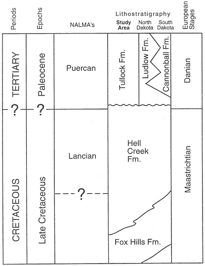
Figure 2
Correlation chart (modified from Bryant, 1989: figure 2), showing lithologic
units in the study area (McCone County, Montana) and North and South
Dakota. Correlation of lithologic units, geochronologic units, and NALMA's
(North American Land Mammal "Ages" from Wood et al., 1941 and
Russell, 1975) based on Archibald and Lofgren, 1990, and this study.
eastern Montana (Sloan and Van Valen, 1965; and many others). However, use of this terminology in more than a limited area without qualification can cause confusion because it implies regional continuity of each coal bed. When originally proposed, it was stated that this lettering system was not suitable for application in regional correlation: "Bed Z, is probably not a continuous bed but rather a succession of lenses of coal in about the same stratigraphic position" (Collier and Knechtel, 1939:18). And with respect to coals of the Tullock Formation, "correlation of coal beds from place to place is difficult, and beds V, W, X, and Y, are all probably discontinuous, each being merely several lenses at about the same horizon" (ibid., p. 19). Therefore the employment of coal beds as regional correlation tools is problematic because coal beds in eastern Montana can be demonstrably discontinuous (Sholes and Cole, 1981; Archibald, 1982; Fastovsky, 1987).
At McGuire Creek the formational boundary is also recognized as the base of the first coal above the last dinosaurian fossils, but to eliminate potential confusion in correlation, this coal is mapped and designated the McGuire Creek Lignite (MCZ) (Plates 1-4), not the "Z" coal. Therefore, the MCZ is a local stratigraphic unit and has no implied regional significance.
In the McGuire Creek area, the upper Hell Creek Formation is composed primarily of gray and light to dark green sandstones, siltstones, and mudstones. Lesser amounts of purple or dark to light brown siltstones and mudstones are also present. Weakly lithified, very thick (15-20 m) gray sandstones, containing Bug Creek assemblages, are locally abundant in the uppermost 30 m. These sandstones are overlain by a thick and laterally persistent coal, the McGuire Creek Lignite (MCZ), which defines the base of the overlying Tullock Formation. Organic-rich sediments are rare in the upper Hell Creek Formation and usually consist of thin beds of black carbonaceous shale which have limited lateral continuity. However, a thick shaly coal, the Tonstein Lignite (TL), is present about 30 m below the MCZ and is laterally traceable for over 4 km (Plate 1). Studies of the Hell Creek Formation in eastern Montana and the Dakotas are presented by B. Brown, 1907; R. Brown, 1952; Jensen and Varnes, 1964; Frye, 1969; Moore, 1976; Butler 1980; Archibald, 1982; Fastovsky, 1987; and Rigby and Rigby, 1990.
The Tullock Formation at McGuire Creek is composed primarily of gray, yellow, and light brown sandstones, siltstones, and mudstones. In contrast to the Hell Creek Formation, well developed coal beds are common in the Tullock Formation. Tullock sediments are, in general, more resistant to erosion, more tabular and more laterally continuous than Hell Creek beds. The difference in erosive properties is clearly evident in topographic expression in the McGuire Creek area; major cliff development is commonly associated only with the Tullock Formation (Plate 1). Additional descriptions of the Tullock Formation in eastern Montana are provided by Rogers and Lee, 1923; Collier and Knechtel, 1939; Archibald, 1982; Fastovsky, 1987; and Rigby and Rigby, 1990.
Facies Analysis and Geological Correlations
Fastovsky (1987) has published a detailed facies analysis of vertebrate-bearing strata spanning the K-T transition in parts of eastern Montana. General classes of lithofacies
|
Figure 3
Comparison of terminology employed in this and other analyses of lithofacies in the upper
Hell Creek and lower Tullock formations of eastern Montana.
at Bug Creek (Fastovsky and Dott, 1986; Fastovsky, 1987), which is only 1 km north of the McGuire Creek study area, can be recognized and employed at McGuire Creek (see Figure 3). Additions or modification of these facies based on strata at McGuire Creek are given below when necessary. Two additional lithofacies (Facies B and G) were recognized at McGuire Creek and are described in detail.
Facies A
This facies is lithologically similar in part to the Siltstone Facies of Fastovsky, 1987, and Facies B of Fastovsky and Dott, 1986.
Description : Facies A is composed primarily of very thick to medium interbeds of green, gray, and purple, laminated to massive, siltstones and mudstones. Thick (up to 70 cm) lenticular sandstones that fine upward to siltstone or mudstone are also present but rare. Isolated and associated remains of larger-bodied vertebrates, primarily dinosaurs, are present. These occurrences usually are limited to isolated dinosaurian skeletal elements that are widely separated both geographically and stratigraphically. However, occurrences of more complete dinosaurian material were observed. The eroded and scattered remains of a partial ceratopsian skull are present in Section D (Plate 2). Mammalian remains were not recovered from this facies.
Interpretation : Facies A includes floodplain deposits that underwent soil development (Fastovsky, 1987; Fastovsky and McSweeney, 1987). Vertebrate fossils probably represent animal remains that were lying on the floodplain surface or in localized depressions that were subsequently buried by suspended sediment during flooding events. Fossils found in this depositional setting are unlikely to have been reworked from older strata, especially in the case of the ceratopsian skull cited above.
The absence of mammalian and other small-bodied vertebrate remains may be a reflection of the size of skeletal elements. Small bones have high surface-to-volume ratios and would be more readily destroyed during soil formation (Retallack, 1984).
Facies B
Description : Thin to medium interbeds of dark brown, brown, and gray sandstone, siltstone, and mudstone are present. Lenticular, fine-grained sandstones comprise 30-40% of this facies. Sandstone lenses are usually 15-20 cm thick and 15-20 m wide, and the largest observed is 1 m thick and 30 m wide. Sandstones also occur as thin laminated beds interbedded with siltstones and mudstones. Internally, sandstones exhibit ripple and small-scale tangential, planar, and trough (rare) cross-stratification sets. Siltstones and mudstones are laminated or massive, and all lithologies commonly have organic debris and plant macrofossils on laminae. Root casts are present but are rare. Siltstones and mudstones are more laterally continuous than sandstones, and usually can be traced laterally for over 25 m. Facies B fines upward and is overlain by Facies C.
The best exposures of Facies B near Section V (Plates 1, 2) indicate a channel-form morphology with steep bank margins which are deeply entrenched into Facies A beds. The base of Facies B is not exposed here, but a minimum of 6 m of relief is developed on this erosion surface, which dips 25-30 degrees to the east. The orientation of Facies B beds adjacent to this surface conforms to the eastward slope but levels out when traced toward the axis of the channel. This Facies B and Facies A contact trends 165 degrees and can be traced for 1.5 km to the southeast (Plate 1). Exposures of Facies B adjacent to Section V are over 150 m wide. East of these exposures are poorly exposed cross-stratified sandstones (Plate 1).
Articulated and associated remains of aquatic vertebrates including turtles, crocodiles, and champsosaurs are present in Facies B. Mammal and dinosaur remains were not recovered from this facies.
Interpretation : Facies B represents channels that were abandoned and slowly filled with suspended silt and mud. Lenses of cross-stratified sand indicate periodic influx of sand as channelized traction load during flooding events. The abundance of plant fossils but rarity of root traces suggests that the abandoned channel usually contained standing water. The presence of aquatic vertebrates supports this interpretation. Cross-stratified sandstones lateral (east) of Facies B outcrops (Section V) probably represent previously deposited thalweg channel-fill material.
Facies C
Facies C is lithologically similar to the Facies of Organic Accumulation of Fastovsky, 1987, and Facies D of Fastovsky and Dott, 1986.
Description : Facies C is composed of very thick to medium-bedded black to purple lignite and carbonaceous shale, containing 1-10 cm thick mud partings. Discontinuous or laterally persistent, 2-5 cm thick volcanic ash layers are present in both the McGuire Creek Lignite (MCZ) and Tonstein Lignite (TL). The MCZ and TL each contain a particularly persistent volcanic ash layer whose presence was useful for mapping across disjunct exposures. The MCZ is locally overlain by a 20-50 cm thick, massive, black to dark gray mudstone which is devoid of plant macrofossils and roots. This mudstone is useful for correlation of the MCZ between isolated exposures. Amber granules are abundant in the TL. Vertebrate remains were not recovered from Facies C.
Interpretation : Facies C represents the development of widespread coal-swamp deposits in the McGuire Creek area. Extensive coal-swamp development is evident because the MCZ and TL are laterally traceable over more than 20 and 4 sq. km, respectively (Plate 1). The extensive development of lignites in the McGuire Creek study area is noteworthy because coal horizons at or below the formation boundary can be extremely localized elsewhere (Archibald, 1982; Fastovsky and Dott, 1986; Fastovsky, 1987).
It appears that the TL, and possibly the MCZ, may have significant utility as correlation tools in biostratigraphic studies because they are evidently present in regions north and west of the McGuire Creek study area. A Hell Creek Formation lignite, the Null Coal, mapped within the Bug Creek drainage by Smit et al. (1987) and Rigby and Rigby (1990), almost certainly is equivalent to the TL based on elevation, stratigraphic position, and general lithologic similarity. However, the absence of ash layers in the Null Coal precludes definite correlation (NW quadrant of Section 16, Plate 1, and directly below the Bug Creek Anthills channel fill, NW quadrant of Section 9, T 22 N, R 43 E).
A coal in the upper Hell Creek Formation containing one or two ash layers and amber is exposed at Jawbone Coulee and Thomas Ranch, 5 and 15 km west of the McGuire Creek study area, respectively. The Jawbone Coulee lignite has two ash layers and amber, and closely parallels the TL in general stratigraphic position, lithologic character, and position of ashes within the coal (Section 13, T 22 N, R 42 E). In the opinion of Dr. Carol Hotton (pers. comm., 1989), the TL may also be equivalent to the Tonstein Coal at the Thomas Ranch locality (Hotton, 1988; Section 14, T 22 N, R 41 E) based on approximate stratigraphic position, presence of an ash layer, and abundant amber granules.
The MCZ is difficult to trace into the northern part of the study area, and correlations become questionable (Plate 1). Correlation between lignites is especially difficult to the northwest (Section HH) because of discontinuous exposures and thinning of coals. It appears that the MCZ and upper "Z" coal of the lower Bug Creek drainage (not including Russell Basin) are two different units (Section OO, Plate 4). However, mapping north of Section DD (Plate 4) indicates that the MCZ is traceable northward into the headwaters of the Bug Creek drainage and is equivalent to the uppermost lignite of the "Z" complex at Russell Basin (upper "Z" of Smit et al., 1987 and Rigby and Rigby, 1990). It appears that the upper "Z" and MCZ (Section OO) are two units of a series of thin lignites that comprise the upper "Z" complex of Russell Basin.
Facies D
Facies D is lithologically similar to the Variegated Facies of Fastovsky, 1987; Facies E of Fastovsky and Dott, 1986; and the "variegated" beds of Archibald, 1982.
Description : Facies D is composed of thin to medium interbeds of yellow-brown or gray laminated siltstone and mudstone. Thin individual beds can be traced for hundreds of meters laterally in continuous exposures. Facies D, as a whole, is laterally traceable for over 25 sq. km in the McGuire Creek area. Facies D contains isolated occurrences of articulated elements of turtles and champsosaurs.
Interpretation : Facies D represents extensive pond deposits (Fastovsky, 1987).
Facies E
Facies E is lithologically similar to the Facies of Epsilon Cross-Stratification of Fastovsky, 1987, and Facies C of Fastovsky and Dott, 1986.
Description : Facies E is composed of 3-20 m thick gray sandstones in elongate sheet morphologies whose base is scoured into Facies A or another Facies E unit (Plate 3). Basal scours are commonly flat but can also exhibit over 5 m of relief (Little Roundtop Channel, Sections Q and 861, Plate 3). Weakly to well-defined inclined heterolithic stratification (IHS) (following Thomas et al., 1987, this term replaces "epsilon cross-stratification") sets are present that exceed 15 m in thickness and exhibit dips of 10-20 degrees. IHS is defined by alternating beds of sandstone, siltstone, and mudstone. It extends down to the basal scour in some cases (Little Roundtop Channel, Plate 3), but in others (Second Level Channel, Plates 3 and 4) the basal 1-7 m is composed of thick, vertically stacked sets of trough cross-stratified sandstone (similar to Facies F) which fine upward in both grain size and scale of sedimentary structures before interfingering with IHS (Sections 861, Q, R, Plate 3; Section T, Plate 2; Sections R, 871, Plate 4; Sections O, P, Plate 4). Paleocurrents of trough cross-strata are approximately perpendicular to IHS surfaces (Figure 4). Complete Facies E sequences fine up to siltstone and mudstone and are overlain by Facies C, or Facies G and C.
Poorly sorted, clast-to matrix-supported lag concentrations of clayball conglomerate, carbonized plant debris, fossil wood, and vertebrate fossils are commonly present at the base of Facies E channels. Basal lags consist of discontinuous 30-100 cm thick lenses of poorly sorted, clast-supported, pebble-cobble conglomerates composed of rounded mudstone and siltstone clasts. Conglomerates also occur as lenses within or underlying trough cross-bedded, medium to fine grained sandstone. Fragments and impressions of carbonized plant debris are abundant, while fossilized wood is rare. Localized depressions in channel floors are commonly filled with conglomerates containing rich concentrations of microvertebrate fossils. These fossil remains usually consist of isolated teeth and disarticulated elements (complete elements are rare) of aquatic and terrestrial vertebrates which have undergone hydraulic transport and sorting. Fossils are commonly fragmentary and abraded, but many pristine bones and teeth were also recovered. Fossils are intermixed with pebble-sized intraclasts that apparently have similar settling velocities (this is not true for larger fossils). Isolated teeth of mammals and dinosaurs are common, and fragments of shed ceratopsian teeth com-
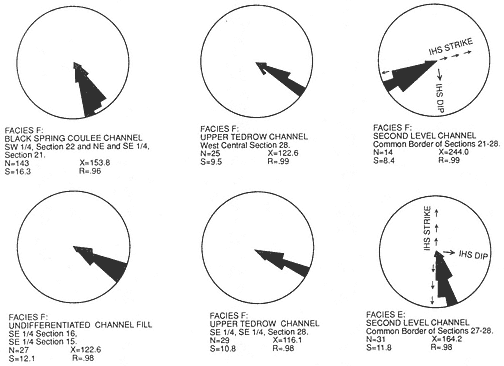
Figure 4
Trough cross-bedding orientations measured in the upper Hell Creek Formation at McGuire
Creek. Data presented are grouped by mapped channel fill except where noted N= number of
measurements; X= vector mean in degrees; S= circular dispersion in degrees; R= vector
magnitude. See Plate 1 for location of channel fills measured.
prise the great majority of dinosaurian dental remains. Mammal jaws are uncommon, and mammalian maxillary fragments are rare. In comparison to the number of dental remains at any one site, mammalian postcranial elements are under represented and usually consist of dense elements such as phalanges, carpals, tarsals, and distal or proximal fragments of other limb bones. Vertebrate fossils were not found on IHS surfaces or immediately above the base of Facies E sequences.
Facies E lag concentrations which produce Bug Creek vertebrate assemblages are the Brown-Grey, Second Level, and Little Roundtop channel fills. The Z-Line Channel does not cut deeply into Facies A beds and yields a Puercan assemblage. Well-preserved teeth and many heavily abraded fragments of dinosaur bone are present at locality V87072 (Brown-Grey Channel).
Interpretation : Facies E represents laterally accreted channel-fill deposits. IHS is interpreted as lateral accretion surfaces of point-bar deposits (Fastovsky, 1987), while thick trough cross-strata in the lower region of Facies E channel fills represent vertically accreted thalweg sandstones (Mossup and Flach, 1983). Facies E channels were
entrenched into pre-existing Facies A units. Superposed Facies E fills (Little Roundtop and Second Level channels, Plates 3 and 4) indicate that multiple channel cutting and filling events also occurred. Therefore, considerable reworking of pre-existing strata and their entombed vertebrate remains probably occurred.
Facies F
Facies F is lithologically similar to the Cross-Stratified Sandstone Facies of Fastovsky, 1987, and Facies A of Fastovsky and Dott, 1986.
Description : Facies F is composed of 10-20 m thick, multi-storied, gray sand bodies which are commonly overlain by Facies G and C, and usually sharply bounded below by Facies A. Facies F units truncate Facies E channels and also Facies D and C deposits above the MCZ (Plates 2-4). Relief on these erosion surfaces exceeds 15 m (Sections II and 811 or Sections O, P, 856, and 855, Plate 4; Sections H-B, Plate 2).
Individual stories are lenticular, have a sharp undulatory base, and are about 2-10 m thick and 10-50 m wide. Successive stories are commonly incised into preceding channel-fill cycles, and several erosion events can be seen in good exposures (for example, Section H, Plate 2). Limited three-dimensional exposure of some stories shows that they have channel-form geometries with subparallel axes. Paleocurrent data indicates a south-southeast flow direction with a markedly unidirectional trend (Figure 4). Mapped Facies F sand bodies exhibit widths of approximately 0.5 km perpendicular to paleocurrent means (Plate 1).
Relatively complete stories exhibit a decrease in scale of sedimentary structures from very thick or thick sets of trough and planar cross-stratification to medium or thin sets of trough, planar, and ripple cross-stratification, overlain by siltstone. Sediments within most stories fine upward from medium grained sandstone with minor amounts of mudstone pebble conglomerate at the base to organic rich fine-grained sandstone or siltstone at the top.
Basal scours of Facies F sand bodies commonly exhibit localized lag concentrations of poorly sorted, clast- and matrix-supported, clayball conglomerates which contain fossil wood, carbonized plant debris, and vertebrate fossils (see Facies E for a general description of the depositional setting of these vertebrate remains). In Facies F, vertebrate fossil remains were rarely found above the basal lag of the lowest story.
Facies F lag concentrations which produce Bug Creek assemblages are the Black Spring Coulee and possibly the Upper Tedrow and "Lower Tedrow" channel fills. Jacks Channel produces a Puercan vertebrate assemblage. Vertebrate fossil occurrences in lag concentrations usually consist of isolated elements, but abundant well-preserved dinosaur material is present at Black Spring Coulee (V87030; see the following chapter on Reworking of Fossils for discussion).
Interpretation : Facies F multi-storied sand bodies were probably developed through vertical aggradation in laterally stable channels of low sinuosity. The subparallel channel-form geometries of each story, low divergence of paleocurrents, and absence of lateral accretion features such as IHS support this interpretation. Upward decrease in grain size and scale of sedimentary structures within each story records waning paleoflow strength between flood events. Multiple scour and fill events occurred within channels, as evidenced by entrenchment of superposed stories. The deep entrenchment of Facies F channels into pre-existing sediments suggests that considerable reworking of fossils occurred.
Other channel fills, not assignable to a channel facies because of poor exposures, contain important occurrences of vertebrate fossils. The K-Mark Channel yields a Lancian vertebrate assemblage. Matt's Dino Quarry Channel produces disarticulated but closely associated hadrosaur skeletal elements and a complete turtle shell. The Shiprock and Up-Up-the-Creek sites yield Bug Creek assemblages.
Facies G
Description : Facies G is composed of tabular interbeds of thin to thick brown, gray, and greenish-gray sandstone, siltstone, and mudstone. Sandstones comprise 20-30% of this facies and are commonly laminated, but also exhibit ripple and small scale planar cross-stratification. Sandstones also occur as elongate lenses up to 10 cm thick within siltstones. Siltstones and mudstones are laminated and contain organic debris and well-preserved plant macrofossils on laminae. Complete leaves are extremely abundant locally in all laminated lithologies, and large palm fronds were observed. Fossilized in situ tree stumps are present at sections B and H (Plate 2). Root casts are present, but are not common. Individual sandstone, siltstone, and mudstone units are commonly traceable over tens of meters.
Thin black carbonaceous shales-mudstones composed of fissile mats of laminated plant debris are also present, and are traceable for hundreds of meters in continuous exposures. Articulated and associated remains of turtles, champsosaurs, and crocodiles are abundant in carbonaceous shales-mudstones. Neither mammals nor dinosaurs were recovered from this facies.
Facies G overlies floodplain facies (Facies A, east part of Plate 2) and overlies and interfingers with channel facies (Facies E and F, Plates 2-4). Facies G can be a continuum with Facies, A, E, and F and boundary recognition must be arbitrarily determined in many cases. However, with respect to Facies G and A, they differ in color, and Facies G beds are more tabular and laterally continuous. Also, Facies G sediments contain well-preserved plant macrofossils (including in situ tree stumps) and internal bedding features (laminations and ripples).
Interpretation : Facies G represents floodplain deposits developed in association with channel facies. These floodplain deposits comprise the culmination of fining upward sequences of channel facies (E and F), or the lateral floodbasin deposits of these channels. Extensive but short-lived swamps were developed on floodplains, as evidenced by the thin but laterally continuous carbonaceous shales containing abundant aquatic vertebrates. Cross-stratified sandstones probably represent minor crevasse-splay development on the floodplains. The presence of tree stumps, abundant plant macrofossils, and root traces indicates that these floodplains were probably heavily vegetated. However, paleosol development was generally not as advanced as in Facies A because delicate sedimentary structures such as laminations and whole-leaf plant fossils are extremely abundant and well preserved.
Geologic History of the McGuire Creek Area
A geologic history spanning the upper Hell Creek and lower Tullock formations at the McGuire Creek area can be constructed based on superposition, cross-cutting relationships, and interfingering between the facies described above. This sequence of events applies only to the study area at McGuire Creek.
Sediments within the upper but not uppermost Hell Creek Formation at McGuire Creek consist primarily of floodplain facies (Facies A; Plates 2-4). Floodplain facies also contain evidence of small-scale stream and extensive peat swamp development (e.g. TL: Tonstein Lignite). In situ dinosaur remains above and below the TL indicate that dinosaurs inhabited these floodplains.
The predominantly floodplain deposits of Facies A were then scoured by a series of major streams. Channels created by these streams were filled by sediments representing Facies B, E, and F. The thickness of IHS sets (up to 10 m; Sections 861, Q, R, Plate 3) and of the channel fills themselves (up to 20 m; Section II, Plate 4) indicate that these streams were very large. Over 15 m of relief is present on the contact between floodplains (Facies A) and channel-fill facies (Facies B, E, F; see Sections II through 811, Plate 4; and Sections H through B, Plate 2). The 15 m of relief indicates that stream channels were deeply entrenched into floodplains. As a result, the erosion surface developed on floodplain deposits (Facies A) is traceable for over 3 km (Sections K through R, Plate 3; Sections R through II and O through 855, Plate 4). An immense volume of previously deposited strata (mostly Facies A) was removed during these channeling events, and the likelihood that vertebrate remains were reworked is high. Channels were filled by vertically accreted (Facies F) or laterally accreted (Facies E) sandy sediment, while others were abandoned and filled primarily by finer-grained sediment that settled from suspension (Facies B).
A complex record of superpositional and cross-cutting relationships between laterally accreted (Facies E) and vertically accreted (Facies F) channels indicates the occurrence of multiple channel and fill events within this stratigraphic interval (below MCZ, above TL). Channels were deeply entrenched into pre-existing channel facies as well as floodplains (Facies A), and considerable reworking of vertebrate remains must have occurred. Eight mapped channel-fill units, six of which represent individual channel fills, are evidence of this complexity (Plates 1-4). Excellent exposures permit temporal sequencing of a limited number of these channeling events (a simplified version of channel-fill relationships is presented in Figure 5 and should be referred to in the following discussion). Superpositional and cross-cutting relationships indicate that the oldest demonstrable channel fill (of the six that were individually mapped) is the Little Roundtop Channel, which is scoured and overlain by the Second Level Channel (Plates 3, 4). The Second Level Channel is cut by both the Black Spring Coulee and Upper Tedrow Channel fills (Plates 3, 4). The Upper Tedrow channel cuts both the Brown-Grey and "Lower Tedrow" channel fills (Plate 3) ("Lower Tedrow" and Upper Tedrow channels may be equivalent, see section below on The Tedrow Area). These cross-cutting relationships reveal that both the Upper Tedrow and Black Spring Coulee channel fills are younger than the Little
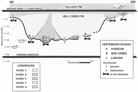
Figure 5
Schematic stratigraphic relationships of lignites, channel fills yielding vertebrate faunas, floodplain deposits
with in situ dinosaur remains (horizontal long-bone figures), sediment samples analyzed for pollen, and age
interpretation of palynofloras. Horizontal distance depicted is approximately 5 km in NE-SW orientation.
Channel fills (or Local faunas) are: (MD) Matt's Dino Quarry; (KM) K-Mark; (BS) Black Spring Coulee;
(LR) Little Roundtop; (SL) Second Level; (SR) Shiprock; (UT) Upper Tedrow; (BG) Brown-Grey Channel;
(UU) Up-Up-the-Creek; (ZL) Z-Line; (JC) Jacks Channel. KM and MD are not superpositionally overlain by
the MCZ as shown, but are actually at the tops of isolated buttes.KM, MD, UU, and SR could be either
Facies E or F. Heavy line denotes the erosion surface created by successive channeling events.
Roundtop Channel. Temporal relationships that remain uncertain are those between the Black Spring Coulee and Upper Tedrow, Brown-Grey and Little Roundtop, and Brown-Grey and Second Level channel fills. Physical relationships of the Z-Line Channel to any of the other five channel fills cannot be determined.
Three types of vertebrate assemblages (Lancian, Bug Creek, and Puercan) were collected from lag deposits in Facies E, Facies F, or undifferentiated channel fills within this stratigraphic interval. Z-Line (Facies E) is the only channel fill that preserves a Puercan fauna below the MCZ (refer to Figure 5). Bug Creek assemblages are present in the Little Roundtop, Second Level, Black Spring Coulee, and Brown-Grey channel fills, and the Shiprock and Up-Up-the-Creek sites. A Lancian assemblage is present only in the K-Mark Channel, an erosional remnant of a channel fill of unknown size and facies (Plate 3). Matt's Dino Quarry yielded an associated hadrosaur skeleton in a channel fill of undetermined facies (Plate 3), but mammals were not recovered.
The presence of Lancian, Bug Creek, and Puercan vertebrate assemblages in nearly identical facies in the same stratigraphic interval undoubtedly indicates that some degree of faunal change was occurring at this time. However, because of discontinuous exposures and the lenticular nature of channel facies, temporal sequencing of the three assemblages by superpositional or cross-cutting relationships cannot be determined. Interpretations of faunal change at this stratigraphic interval are ambiguous because they cannot be clearly supported by a superposed stratigraphic sequence of faunas.
Channel fills (Facies B, E, F) commonly fine upward and/or grade laterally into floodplain deposits (Facies G). These floodplains were accreted in unison with channel migration (Facies E) or were developed after vertically accreted channels (Facies B, F) were filled. Facies G floodplains also overlie Facies A floodplains. Areas that preserve this relationship are Sections II and 811 (Plate 4; Figure 5, base of BS traced to left) and Sections B through H (Plate 3; Figure 5, just right of UU, then traced to right). These sections show that channels (Facies F) which produce Bug Creek assemblages (Black Spring Coulee Channel) interfinger with floodplain deposits (Facies G) that contain aquatic vertebrates but lack dinosaurs. In the absence of a facies bias, it appears that the lack of dinosaurs in Facies G floodplains indicates that they were extinct by this time, at least locally. Paradoxically, where it can be determined, floodplains (Facies G) that lack dinosaur remains appear to have accreted in unison with channels (Facies F) that yield dinosaurs in lag concentrations (Section II, Black Spring Coulee Channel, Plate 4; Sections H-B, Plate 2). However, the presence of dinosaur remains in these channel fills is probably the result of reworking (see Lofgren at al., 1990). Reworking would explain why disarticulated remains of dinosaurs are present in channel facies (Facies F) but are absent in contemporaneous floodplain facies (Facies G).
Based on topographic elevation, the stratigraphic level of the basal lags of channels (Facies E, F) which contain Bug Creek assemblages are equivalent to floodplains (Facies A) containing in situ dinosaurs. However, lateral correlation of Facies F channels containing Bug Creek assemblages indicates that these channels interfinger with Facies G floodplains, not Facies A floodplains (Sections II through 8111, Plate 4; Sections B through H, Plate 2). This is a reflection of the deep entrenchment of channels into older floodplain
deposits (Facies A), where as much as 20 m of relief is observed. Therefore, correlation of facies provides a more reliable method of determining relative age than elevation or relative (to laterally persistent coals) stratigraphic level. Analysis of facies relationships of vertebrate-bearing fluvial deposits is critical because faunas present at the same stratigraphic level or elevation could differ significantly in age.
In contrast to the examples where channels containing Bug Creek assemblages can be traced into age-equivalent floodplains, the relationship of channel fills bearing Puercan or Lancian vertebrate assemblages to age-equivalent floodplain deposits (Facies A or G) cannot be determined. The K-Mark Channel and Matt's Dino Quarry site are located at the top of isolated buttes, making lateral correlation to floodplain deposits impossible. The margins of the Z-Line Channel (Facies E) are not exposed in contact with floodplain deposits.
Complete channel-fill (Facies B, E, F) sequences fine upward into floodplains (Facies G) and are all overlain by a laterally extensive lignite (Facies C), the MCZ (base of the Tullock Formation). This indicates that, following the episode of major channeling and erosion, a large peat swamp was developed which blanketed most of the study area. This swamp was in turn replaced by development of extensive areas of standing water, represented by thick sequences of pond deposits (Facies D).
Pond deposits (Facies D) are overlain by fluvial sediments that aggraded in various depositional settings. Of interest are channels (Facies F) with lag concentrations containing vertebrate fossils that are deeply entrenched (up to 15 m) into pond deposits (Facies D) overlying the MCZ (Facies C). These channels, for example, Jacks Channel (Plates 2, 3), contain Puercan assemblages (which lack dinosaurs and typical Lancian mammals). Remains of dinosaurs are not present above the MCZ in the McGuire Creek area, and apparently dinosaurs were extinct by this time (but see Rigby, 1989).
Palynological Correlation of McGuire Creek Lithofacies
It has long been known that a palynological change that could be recognized in stratigraphic sequences in eastern Montana was roughly coincident with R. Brown's (1952) formula (first coal above highest dinosaur) for the terrestrial K-T boundary (Norton and Hall, 1969; Oltz, 1969; Tschudy, 1970). Based on more recent refinements, Cretaceous strata can be differentiated from Tertiary strata by the absence or great reduction in abundance of Cretaceous indicator species in the latter (Smit et al., 1987; Hotton, 1988). Therefore, palynology can be used for determining the relative age of vertebrate-bearing strata in the upper Hell Creek Formation where lithostratigraphic relationships are unclear, if one facies yields a Cretaceous palynoflora while another contains a Tertiary pollen assemblage. (For discussion of palynological recognition of the K-T boundary, see chapter below on Cretaceous-Tertiary Correlations). Thus, palynology is useful in correlating between disjunct exposures of channel (E, F, B) facies and/or floodplain facies (A, G). The results of palynological analyses of rock samples from McGuire Creek are given in Table 2.
Palynological correlation indicates that channel facies with Bug Creek or Puercan assemblages (Facies E, F) are younger than floodplain facies containing in situ dinosaur
| ||||||||||||||||||||||||||||||||||||||||||||||||||||||||||||||||||||||||||||||||||||||||||||||||||||||||||||||||||||||||||||||||||||||||||||||||||||||||||||
| ||||||||||||||||||||||||||||||||||||||||||
remains (Facies A). Facies G floodplain deposits were not analyzed for pollen, but they are Paleocene, because they unequivocally overlie channel fills or Facies A floodplain deposits that produce Paleocene pollen. In contrast, Facies A floodplain deposits may be Paleocene or Cretaceous in age, depending upon the stratigraphic interval sampled. Where channel facies are deeply entrenched into Facies A floodplain deposits, these floodplain deposits are Cretaceous in age, based on pollen (Section FF, Plate 3, and Sections II and O, Plate 4). Where Facies G overlie Facies A floodplain deposits, the uppermost portion of Facies A deposits are palynologically Paleocene (Sections D and B, Plate 2). Smaller-scale channel entrenchment (less than 3 m) into Facies A floodplains containing Paleocene pollen occurs at Section N (Plate 2). Where sampled, Facies A beds that contain in situ dinosaurs produce Cretaceous pollen (Section O, Plate 4; the same bed in Section E from which rock sample 87DLL7-16-21 was collected produced a disarticulated ceratopsian skull 150 m to the south). In situ dinosaurs have not been found in Facies G floodplain deposits that yield Paleocene pollen (but these floodplain deposits yield turtles, champsosaurs, and crocodiles; Sections B-D, Plate 2). Without exception at McGuire Creek, in situ dinosaur remains have not been found in the stratigraphically lowest Paleocene floodplain deposits (as identified palynologically). This is also true in other K-T transition stratigraphic sequences of floodplain deposits in eastern Montana,
where the highest in situ dinosaur remains are never found within 2 m (below) of the palynological boundary (Archibald, 1987c).
Channel fills containing vertebrate fossils in the uppermost Hell Creek Formation were sampled for pollen when suitable lithologies were present. Otherwise, ages of channel fills were determined by superpositional or cross-cutting relationships with another rock unit whose age was determined palynologically. The results of these analyses are given in Table 3 and Figure 5.
All channels containing Bug Creek or Puercan vertebrate assemblages are demonstrated to be of Paleocene age where palynological determination is possible (Table 3; Plates 2-4, Figure 5). Therefore, channel fills containing Bug Creek or Puercan assemblages are palynologically equivalent to floodplain deposits that lack in situ dinosaurs (Facies A and G) and are palynologically dissimilar to floodplain deposits that contain in situ dinosaurs (Facies A).
Similar conclusions, based on lithostratigraphy and palynology, are reached concerning the timing of geologic events in the uppermost Hell Creek Formation at McGuire Creek. Lithofacies correlation indicates that channels (Facies B, E, and F) are entrenched into floodplain deposits (Facies A) containing in situ dinosaur remains (Figure 5; Plates 2-4). Limited lateral correlation of channels (Facies F) suggests interfingering with floodplain deposits that lack dinosaurs (Facies G) (Figure 5; Plates 2, 4). It appears, on the basis of palynology, that deep entrenchment of Paleocene channels into a pre-existing landscape composed of mostly Cretaceous and less commonly Paleocene floodplain deposits occurred; this erosion surface denotes the palynological K-T boundary (shown by heavy line in Figure 5). Correlation of channel facies (Facies E, F, B) laterally to floodplain facies (Facies G) is corroborated by palynological analysis. If present, the uppermost parts of Facies A floodplain deposits that lack in situ dinosaur remains are Paleocene. These strata may be remnants of floodplain deposits accreted lateral to Paleocene channels whose isolated vestiges (for example, the Little Roundtop or Brown-Grey channels) cannot be traced laterally into floodplain sequences because of repeated channeling.
In no case at McGuire Creek is a Bug Creek or Puercan vertebrate assemblage clearly associated with a Cretaceous palynoflora. The basal lags of these channels may contain reworked mud pebbles, cobbles, and boulders that produce Cretaceous pollen (Lofgren et al., 1990) but the channel fills yield Paleocene pollen where sampled (Table 3; Figure 5).
Relative age discrimination of individual channel fills containing Lancian, Bug Creek, or Puercan assemblages in the upper Hell Creek Formation at McGuire Creek is severely limited because all but one yield Paleocene palynofloras (Table 3; Figure 5). Matt's Dino Quarry Channel contains associated hadrosaur skeletal remains (but lacks mammals), yields a Cretaceous palynoflora, and is the only site that is demonstrably older than the others listed in Table 3. The only identifiable Lancian site, the K-Mark Channel, probably is palynologically Cretaceous, but this cannot be confirmed because the sediments are unsuitable for pollen analysis.
McGuire Creek Biostratigraphy
Development of biostratigraphic units at McGuire Creek that span the uppermost Hell Creek Formation is limited because of the lack of stratigraphic control on channel fills that yield fossil assemblages. References to Plates 2-4 are given to demonstrate biostratigraphic relationships in the following discussion (simplified version in Figure 5).
In spite of poor stratigraphic control, superpositional or cross-cutting relationships between channel facies or lignite beds (TL or MCZ) can be determined in some cases. The Jacks Channel local fauna (Puercan) is younger than the others listed in Table 3 because Jacks Channel lies entirely above the MCZ (Section EE, Plates 2 and 3). The other local faunas were collected from channel fills that are (or apparently were) capped by the MCZ prior to Holocene erosion.
Below the MCZ, limited temporal ordering of local faunas containing Bug Creek assemblages can be determined. The Little Roundtop Local Fauna is older than the Second Level Local Fauna because these respective channel fills are in superposition (Sections 861-R, Plate 3). The crosscutting relationship between the channel fills reveals that the Black Spring Coulee Local Fauna is younger than the Second Level Local Fauna (Section 871-II, Plate 4). The Upper Tedrow Channel cuts and/or overlies both the Second Level (Sections O-P-856-855, Plate 4) and Brown-Grey (Section GG, Plate 3) channels. The biostratigraphic utility of these relationships is limited, however, because only one mammal, Meniscoessus robustus , has been found in the Upper Tedrow Channel. The "Three Buttes Local Fauna" is an informal grouping of vertebrate assemblages found in the erosional remnants of channel fill(s) in an area adjacent to exposures mapped as Upper Tedrow or Second Level channels (Plate 1; NE quadrant, SE quadrant, Section 28, T 22N, R 43 E). However, lag deposits which produce fossils included within this "local fauna" are poorly constrained stratigraphically and cannot be correlated with either channel fill because of Holocene erosion of intervening exposures ("Three Buttes Local Fauna" is placed in quotations in Appendix 2 to denote this uncertainty).
The remaining channel fills containing the Lancian (K-Mark, Section BB, Plate 3), other Bug Creek (Shiprock, Section M1, Plate 3; Up-Up-the-Creek, Plate 1), and Puercan (Z-Line, Sections JJ-N-W, Plate 2) local faunas lack stratigraphic control, making their temporal relationships uncertain (other than relative to Jacks Channel). Usually lateral correlation of strata that cap each channel fill would aid in determining relative age, but all upper Hell Creek channel fills are (or apparently were) capped by the same laterally traceable stratigraphic unit, the MCZ.
Palynological data adds little information useful for more detailed biostratigraphic zonation of the uppermost Hell Creek Formation because all sites yielding vertebrates (with the exception of Matt's Dino Quarry Channel) yield similar palynofloras (Table 3, Figure 5).
In summary, it is virtually impossible to develop a local biostratigraphic zonation for the upper Hell Creek Formation at McGuire Creek that orders the three kinds of vertebrate assemblages. The uppermost 25 m of the Hell Creek Formation contains the records of a major faunal turnover, but the transition is recorded within channel-filling events that are not amenable to biostratigraphic subdivision.
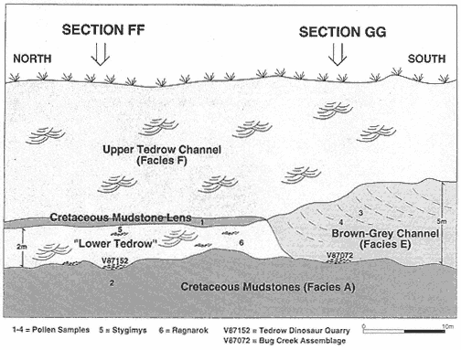
Figure 6
Idealized cross-section of the Tedrow Area showing location of fossil and rock sample sites,
channel fills, and contacts between depositional units. The position of measured sections FF
and GG are shown on Plate 3. Rock samples analyzed for pollen are: (1) 86DLL7-29-1:
Cretaceous; (2) 86DLL7-29-2: Cretaceous; (3) 88DLL7-14-30: Paleocene; (4) 88DLL7-14-13:
Paleocene. Isolated mammal specimens are: (5) Stygimys incisors. (6) Ragnarok lower molars.
The Tedrow Area
The complexity of channel cutting and filling in the uppermost Hell Creek Formation is shown in the Tedrow area (the term "Tedrow area" describes exposures adjacent to and including Sections FF-GG, Plate 3; Figure 6). The Brown-Grey, Upper Tedrow, and "Lower Tedrow" channel fills, and a mudstone lens containing Cretaceous pollen, are exposed in the Tedrow area, but determination of a sequence of depositional events for the channel fills and mudstone lens is difficult because Holocene erosion has removed critical information. These difficulties highlight the uncertainty inherent in biostratigraphic study of complex fluvial channel deposits, even in an area in which three-dimensional exposures are available.
The "Lower Tedrow" Channel is a trough cross-stratified sandstone containing a sparsely sampled vertebrate fauna consisting of associated ceratopsian skeletal remains (Figure 7) and a few isolated mammal teeth referable to Ragnarok and
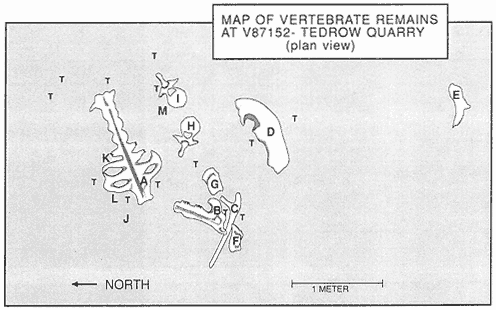
Figure 7
Plan view of Tedrow Dinosaur Quarry (V87152). Letters on quarry map identify the following
elements: (A) Sacrum: broken at base of neural arch over nearly entire length, entire dorsal
part of sacrum absent. Transverse processes missing on many vertebrae. (B) Mandible (right):
edentulous; dentary, surangular, and possibly angular present. Dental battery fractured-
weathered. (C) Dorsal rib #2 (left): distal end of shaft lost. (D) Squamosal (right): lateral edge
and posterior portion of parietal suture present; broken medially at site of large ventro-medial
depression. (E) Squamosal fragment (left): only posterior portion present. (F) and (G) Squamosal
fragments (left): can be rearticulated; groove for quadrate (F) and heavy ridge of bone
(across F-G) against which process of exoccipital abuts present; E-F-G from same squamosal.
(H) Cervical vertebra #7: end of right transverse process lost. (I) Cervical vertebra #6. Note: J, K,
L, M, and T not figured. (J) Cervical vertebra #8?: 50% of vertebra recovered as float; neural
arch reconstructed. (K) Two unidentified fragments: wedged against sacrum; one fragment
well rounded. (L) Frill? fragment (27×10 cm) nestled against sacrum. (M) Frill? fragment
(14×10 cm). (T) Turtle shell fragments scattered throughout quarry; many from one individual
of Adocus . Also present, but not shown, are many unidentifiable bone fragments (<12 cm length).
Stygimys . The dinosaur remains were quarried from the basal lag of the channel fill, which also contained clay balls, fragments of turtle shell, and carbonized plant debris (V87152, Figures 6, 7). Two molars of Ragnarok and two incisors of Stygimys were collected .7-.8 m and 1.5-1.7 m above the base of the channel fill, respectively (Figure 6). These specimens occur within troughs containing clay balls and other vertebrate fossils. It is uncertain if the dinosaur remains and the mammals occur within sediments deposited in the same depositional event (see discussion of Upper Tedrow Channel below).
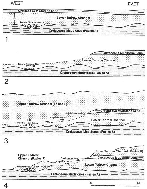
Figure 8
Scenario 1 sequence. (1) Deposition of Lower Tedrow Channel fill with dinosaur remains in
basal lag, capped by mudstone lens with Cretaceous pollen. (2) Partial removal of 1 during
entrenchment of Upper Tedrow Channel. Dinosaur remains in Lower Tedrow Channel fill not
disturbed. (3) Deposition of Upper Tedrow Channel fill, including the mammals Stygimys and
Ragnarok . (4) Area as exposed today. In this scenario, the associated dinosaur remains
and the mammals were deposited in separate filling events or stories. Based on pollen,
the lower story with the dinosaur bones would be Cretaceous and the higher story with
the mammal teeth would be Paleocene.
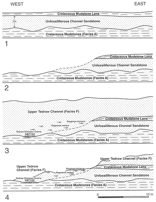
Figure 9
Scenario 2 sequence. (1) Deposition of unfossiliferous sandstone channel fill, capped by
a mudstone lens containing Cretaceous pollen. (2) Partial removal of 1 during entrenchment
of Upper Tedrow Channel. (3) Deposition of Upper Tedrow Channel fill, with dinosaur remains
in basal lag and the mammals Stygimys and Ragnarok higher in the fill. (4) Area as exposed
today. In this scenario, all the vertebrate remains in the "Lower Tedrow" Channel are Paleocene
unless reworked from Cretaceous sediments. Also, the "Lower Tedrow" Channel is a localized
depression in the Upper Tedrow Channel, and both were filled at about the same time.
The "Lower Tedrow" Channel could be Cretaceous or Paleocene, depending on whether it is part of the Upper Tedrow Channel. Situated 2 m above (topographically) the base of the "Lower Tedrow" Channel is a thick mudstone lens containing Cretaceous pollen (Lofgren and Hotton, 1988), which is overlain by the Upper Tedrow Channel (Figure 6). It is uncertain whether this mudstone ever extended across the part of the channel fill that produced the dinosaur remains (contra Lofgren and Hotton, 1988) and mammal teeth. Erosion has removed the critical area in which the Cretaceous mudstone lens would have been either in superposition above part of the "Lower Tedrow" Channel or clearly cut out by the Upper Tedrow Channel (Figures 8, 9). If the latter were true, then the "Lower Tedrow" Channel would represent a localized depression in the Upper Tedrow Channel (Figure 9, nos. 2-3).
The Brown-Grey Channel contains a well sampled Bug Creek assemblage in its basal lag (V87072, Figure 6) and its palynological age is Paleocene. This channel fill cuts the mudstone lens containing Cretaceous pollen. Lofgren and Hotton (1988) thought that the mudstone lens overlay the Brown-Grey Channel; this is now known to be incorrect.
Upper Tedrow is a multi-storied channel fill whose lowest story may include part or all of the "Lower Tedrow" Channel. The Upper Tedrow Channel is Paleocene because it cuts the Brown-Grey (Figure 6; Section GG, Plate 3) and Second Level channels (Sections P, 856, Plate 4), both of which produce Paleocene pollen (Table 3). Therefore, if part of the "Lower Tedrow" Channel is a localized depression of the Upper Tedrow Channel, it is probably Paleocene in age.
On the basis of preliminary palynological and geological investigations outlined in Lofgren and Hotton (1988), it was thought that the sequence of events in the Tedrow Area was: (1) deposition of the Brown-Grey Channel; (2) entrenchment of the "Lower Tedrow" Channel containing the dinosaur remains and subsequent filling; (3) deposition of the mudstone lens overlying "Lower Tedrow" during the Cretaceous; (4) entrenchment of Upper Tedrow into all three of the above. If this sequence of events were correct, then the "Lower Tedrow" and Brown-Grey channels would be Cretaceous and the Upper Tedrow Channel would be Paleocene. Trenching in the Tedrow area in 1989 revealed that the Brown-Grey Channel cuts the Cretaceous mudstone lens. This is corroborated by the presence of a Paleocene pollen assemblage in samples 88DLL7-14-13 and 88DLL7-14-30 from the Brown-Grey Channel, which also indicates that this channel is younger than the Cretaceous mudstone lens. However, the "Lower Tedrow" Channel appears to cut the Brown-Grey Channel when traced westward. This is impossible, because the Brown-Grey Channel cannot be cut by a channel ("Lower Tedrow") that is capped by a unit (mudstone lens) cut by the Brown-Grey Channel (Figure 6). Therefore, part of the "Lower Tedrow" Channel must be equivalent to the Upper Tedrow scouring event (that cut the Brown-Grey Channel and the Cretaceous mudstone lens). This fact negates a two-stage channeling hypothesis in which all vertebrate remains in the "Lower Tedrow" Channel are Cretaceous, and the "Lower" and Upper Tedrow channels are two distinct cut-and-fill events (contra Lofgren and Hotton, 1988).
Based on available geologic data from the Tedrow Area, two possible scenarios of
depositional events are presented in Figures 8 and 9, and neither can be falsified by direct field observation. If correct, the first hypothesis (Figure 8) would indicate a Cretaceous age for the dinosaur remains and a Paleocene age for the mammals. The second (Figure 9) would indicate a Paleocene age for both the dinosaur remains and the mammals, unless reworking of fossils occurred.
If the dinosaur remains were not reworked, then choosing between the two hypotheses has important implications for the timing of dinosaur extinction. The first hypothesis is more in line with conventional palynological-faunal correlations in which dinosaur remains indicate a Cretaceous age and the mammal Ragnarok indicates a Paleocene age. Ragnarok is only known to occur in clear association with Paleocene palynofloras at McGuire Creek and elsewhere in McCone County (Sloan et al., 1986; Rigby et al., 1987; Rigby, 1989). The associated ceratopsian remains would indicate a Cretaceous age for the base of the channel fill.
The second hypothesis is more controversial, because the presence of associated dinosaur remains in a Paleocene channel fill might suggest dinosaur survival into the Paleocene. The association of disarticulated skeletal material (Figure 7) might suggest that the bones were not reworked. However, reworking of dinosaur remains that persist in near association would be possible if the remains were eroded from nearby bank material and underwent little or no transport. Dinosaur remains have been found in channel deposits containing Paleocene pollen at McGuire Creek and elsewhere (Sloan et al., 1986; Rigby et al., 1987) but that these remains are not reworked from Cretaceous sediments has not been satisfactorily documented (Lofgren et al., 1990). Therefore, if the second hypothesis is correct, the dinosaur remains probably were reworked from nearby Cretaceous sediments into which the Upper Tedrow Channel was entrenched.
In summary, difficulties encountered in biostratigraphic study of complex fluvial deposits in the Tedrow Area indicate that determining a clear sequence of depositional events in even a limited area can be difficult. The complexity of channel cutting and filling in the upper Hell Creek Formation is imposing.