Well-Mapped Examples of Eroded Composite Cones
Composite cones formed during Tertiary time usually have been deeply eroded and their interior structures are exposed. However, these cones are still sufficiently preserved to allow interpretation of the relationship between rock types and the structural framework. The cones we discuss here were chosen because their carefully executed three-dimensional maps with cross sections provide excellent examples of older composite cones.
Broken Top Volcano
At Broken Top volcano, in the southern Cascade Range of Oregon in the U.S., dissection by glaciation has provided a clear view of its interior workings (Crowe and Nolf, 1977). The cone consists of interbedded lava flows, laharic breccias, and other pyroclastic deposits illustrated in Fig. 7.17. The tall cone could not have remained standing without its complex internal framework, which is composed of dikes, sills, and small plutons. Early phases of cone construction were followed by collapse and the formation of a small summit caldera. After further cone construction, the edifice was intruded by plugs, radial and concentric dikes, and sills. Intrusions at Broken Top volcano constitute 5 to 20% of the cone volume.
Tieton Volcano
The Miocene-age Tieton Volcano of Washington has been deeply eroded, exposing radial dike swarms and plugs (Swanson, 1966). Originally, Tieton volcano had a basal diameter of ~11 km and a height of 2.4 km. The composite cone, made up of interbedded breccias, pyroclastic deposits, and block lava flows, overlies a shield composed of andesitic lavas. Within the southern, exposed half of the volcano, 200 dikes form a radial swarm; individual dikes are 2 to 6 m thick, are steeply dipping (70 to 90°), and are mostly andesitic. These dikes would have provided a substantial heat source if they were intruded over a fairly short period of time, but not if they were intruded piecemeal over tens of thousands of years. Such dikes
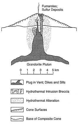
Fig. 7.16
This idealized cross section of a composite
cone and associated intrusive rocks is based
on observations of copper-porphyry
deposits in the Andes of Chile and northern
Argentina. Hydrothermal systems
responsible for the porphyry copper
deposits were established late in the history
of the composite cone; the intrusion and
eruption of rhyolitic magmas followed. In
this model, which is based on a region
with thick crust, the vertical and
horizontal scales are the same.
(After Sillitoe, 1973.)
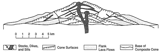
Fig. 7.17
A cross section of Broken Top volcano in the southern Cascade Range of Oregon,
in the U.S. The cone consists of interbedded lava flows, laharic breccias, and other pyroclastic
deposits. The cone could not have supported itself without the complex internal framework of
dikes, sills, and small plutons—all of which give tall composite cones their stability.
(Adapted from Crowe and Nolf, 1977.)
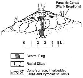
Fig. 7.18
Diagram showing typical dike patterns radial
to the central conduit of a composite cone
and the parasitic cones on the volcano
flanks. The dike swarms follow the trend
of maximum horizontal compression.
(Adapted from Nakamura et al., 1977.)
also act as barriers to groundwater flow and thus can "compartmentalize" aquifers or parts of a hydrothermal system.
Volcanoes of the Aleutian Arc and Alaskan Peninsula
In their study of arc volcanoes of the Aleutian Islands and Alaskan Peninsula, Nakamura et al . (1977) mapped radial dike patterns and parasitic cones on volcano flanks. They concluded that dikes and flank vents on composite cones form elongate swarms in regions under compression and that the swarms follow the trend of the maximum horizontal compression (Fig. 7.18). Inference of the location and dimensions of such dike swarms must be made when siting exploration wells because although they provide the heat source, they also may act as barriers to groundwater flow (see Chapter 6).
Nakamura's observations can be applied to many composite cones that exhibit sector collapse. This type of collapse may occur parallel to the dilational stress within the volcano when the volcano's flanks are forced outward (Siebert, 1984). However, it is more likely that the collapse process is related to the shape of the dike-sill complex within the cone. Composite cones devel-
oped in regions with homogeneous stress are supported by a radial framework of dikes and sills, whereas cones developed in regions strongly influenced by the regional stress regime have dikes that are located mostly along a line parallel to the maximum horizontal compression. Parallel dike systems support only the part of the volcano below a line of parasitic vents; unsupported flanks, with only rare dikes or sills, are subject to sector collapse.
Summer Coon Volcano
The mid-Tertiary-age Summer Coon composite cone in Colorado, mapped by Lipman (1968), is a deeply dissected cone in which the nearly circular complex of stocks is exposed, as are the radial dikes shown in Fig. 7.19. These silicic dikes are as much as 4.8 km long and 60 m wide. Remnants of the cone consist of interbedded tuff-breccias and lava flows of mafic to intermediate
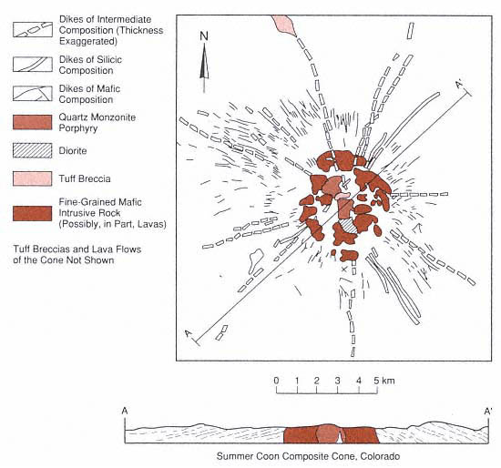
Fig. 7.19
Geologic map and cross section of the mid-Tertiary-age Summer Coon
composite cone in Colorado. This is a deeply dissected cone in which both the
nearly circular complex of stocks and the radial dikes are exposed.
(Adapted from Lipman, 1968.)
compositions. The symmetry of the dike complex reflects fracturing and dike emplacement controlled by stress around the central pluton or plutons and little superimposed tectonic control. The volcano's location on thick continental crust makes the Summer Coon volcano model more similar to volcanoes of the Andean altiplano than to the island arc volcanoes.
Mount St. Helens
Major structural changes to Mount St. Helens in Washington were caused by the sector collapse and eruption on May 18, 1980, in addition to subsequent dome growth. Before the eruption, Mt. Saint Helens consisted of (1) an older volcanic center with nested dacite domes, pyroclastic flows, and mudflow breccias, which was cut by dikes (Fig. 7.13); (2) andesitic and basaltic lava flows interbedded with volcanic breccias and scoria; and (3) dacitic domes (the 370-year BP summit dome and the 180- to 138-year BP domes of the north slope).
After the sector collapse and an avalanche that preceded the most explosive phase of the eruption at Mount St. Helens, an ampitheater-shaped crater remained. The dacite dome within the crater continues to grow (Voight et al ., 1981).