The Age of Master Plans
The first French law on "urbanism" dates from 14 March 1919. Considered "the charter of modern urbanism," this law called for a master plan for every town having more than ten thousand people in
order to regulate growth and enable "beautification" (embellissement ). The plan would thus determine the street network once and for all, specifying the layout and width of all the streets (including the design of new ones and modification of old ones) and the location and character of all open spaces—public parks, gardens, and squares—as well as of monuments and public service buildings.[22] Undoubtedly, the technological, social, and aesthetic lessons learned from city planning practices previously undertaken in French colonies played a primary role in devising official policies for urban development in both metropolitan France and outre-mer . Similar regulations for orderly urban development were in place in other parts of Europe at the time, and while the French were influenced by these trends, they relied more heavily on their own ideas about urban planning. To reiterate a familiar argument, the colonies were true laboratories of modern planning.
Yet although Algiers was the foremost among France's colonial cities, it had never been a real laboratory. Its development had followed a haphazard pattern; decisions were made on the spot, in accordance with the ambiguous and unsettled policies of the early colonial period. In fact, the mistakes made in Algiers were in part responsible for the more orderly planning in other colonies. In turn, the urbanistic lessons learned from the later colonies and empowered by the growing confidence in modernism were reformulated in the 1930s to be applied to France's oldest colonial city. The curious story of Algiers's "rational" planning after 1930 is indicative of the waves of changes in colonial policies, as well as the city's unusual status vis-à-vis France.
Algiers's master plan, a pioneering scheme that put the 1919 law into practice, was approved in 1931 and revised twice, in 1933 and 1934. Initiated by the newly created Service Municipale de l'Urbanisme, it was drafted by Henri Prost, René Danger, and Maurice Rotival. Prost was considered an especially fortunate choice to correct the former errors and offer "new and sound" rules because of his extensive experience in Morocco and the "happy and rational" results he had obtained there. Nevertheless, given the "disordered and incoherent character" of Algiers, expectations were conservative. Lespès, for example, could foresee only "partial improvements" succeeding in the old built fabric; he displayed more optimism for new quarters planned for vacant zones.[23]
Following the new trend in urban planning, the Prost plan (as the master plan came to be known) called for strict zoning, qualified as "methodical discrimination" but based on current needs and tendencies (Fig. 36). The city was divided into four zones, A, B, C, and D. The commercial area, zone A, covered the lower part of Bab el-Oued, the
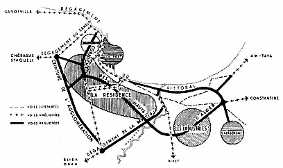
Figure 36.
The Prost plan, 1930–37. Zone A follows the coastline; zone B covers the
area marked as "la résidence"; zone C is on the heights of "la résidence"; zone
D comprises the areas marked as "agglomération" and "industries."
Esplanade Quarter, the old town, Agha, and the middle and inner parts of Mustafa all the way to the Jardin d'Essai; it would be filled with apartment buildings, offices, shops, cafés, restaurants, small workshops, and garages; the roads would be a minimum of 12 meters wide. Zone B was residential and consisted of small, single-family houses (whose maximum height could not exceed 15.2 meters) covering a large and longitudinal area from Bab el-Oued to Mustafa; the streets would again be a minimum of 12 meters wide. Zone C, located on the heights of Mustafa, had "country cottages" in gardens, in an effort to preserve the natural beauty of the particular site. The industrial region, zone D, was on the southern border of Bab el-Oued, as well as to the south, past the Jardin d'Essai. But the real industrial suburb of Algiers was Hussein-Dey. The main roads of the industrial zone were envisioned as 18 meters wide, whereas the secondary ones could be 12 meters. In accordance with the tendencies already in place, industrial working classes were to be housed close to their workplaces, whereas the upper regions of the "amphitheater," which enjoyed a better climate and were in demand by upper classes, would be reserved for villas in gardens and parks.[24]
Within these general outlines, the plan had specific provisions. For example, the Marine Quarter would be demolished completely and re-built; new quarters were to be designed in the area gained by the appro-
priation of the Champs de Manoeuvres, in Mustafa, and on the waterfront near Bab el-Oued; in the densely built quarters, many existing streets would be enlarged and new ones cut through; and the greenbelt defining the heights of Algiers would be preserved, because it was essential for the health, charm, and beauty of the city. The construction of four new roads would improve the communication system of Algiers radically. The corniche along the waterfront would continue the Boulevard de l'Impératrice toward Hussein-Dey and extend for another 13 kilometers; a "ring road" on the zone cleared from the fortifications would add picturesque and aesthetic values to the city; the middle region (the residential section) would be crossed with the help of tunnels which also linked the waterfront to the heights; and, finally, another belt road would envelop the entire agglomeration.[25] One of the first segments of the Prost plan to be completed was the ring road. The Boulevard Laferrière (on the site of the demolished French fortifications), considered to be a great urbanistic achievement, was extended to a vast esplanade of about 3,000 square meters—the "real forum of new Algiers."[26] No longer a traffic artery, it was turned into a lushly planted park with spectacular views. Prost and his colleagues proposed a tunnel under Boulevard Laferrière that would start at the docks (at the Maritime Terminal) and connect to the ring road at the heights (Fig. 37). An exit at Rue d'Isly would enable access to a central location in "downtown" Algiers, close to the Central Post Office, and another exit would lead to the new development of Tagarins farther up the hill.
Rotival justified this ambitious plan by defining the new role that Algiers would play as the capital of an African empire, as a business, commercial, and industrial center, and as a residential town. He likened the task ahead to the rebuilding of Paris under Napoleon III. Confronting the criticism directed at the plan he and his colleagues had drafted, he argued that if Baron Haussmann had not been supported by Napoleon III against his own critics, Paris would now be a "poorly designed village without a future."[27]
The main challenge to the Prost plan came from Le Corbusier, in the form of several (unimplemented) projects for the city between 1932 and 1942.[28] Le Corbusier was not officially commissioned to develop a master plan; his involvement with Algiers had started through an invitation from the Friends of Algiers in 1931 (to deliver a series of lectures on urbanism within the context of the centennial celebrations) and was pursued on his own initiative. While his designs are commonly seen as a critique of French urbanism, in essence they did not diverge radically

Figure 37.
Proposal for a tunnel under Boulevard Laferrière by Prost, Danger,
and Rotival, 1937. (1) Entrance to the tunnel from the maritime
station, (2) access to Rue d'Isly, (3) exit from the tunnel at Tagarins,
(4) rectified rail connection to Télemy, (5) terrace, (6) corniche of
Fort l'Empereur, (7) Ta-garins park, (8) exit from the tunnel at
Frais Vallon.
from the proposals of Prost and his colleagues; the differences were formal, not conceptual, and exaggerated mainly by Le Corbusier's own vast and vigorous propaganda. Le Corbusier began his critique of contemporary urbanism by arguing that French interventions during the last five decades had caused the destruction of Algiers. He wrote: "The last fifty years of European colonization abolished without any regrets the natural richness and petrified the new city into a desert with its crowded houses leaning onto noisy streets." Like the cities of Europe and America, Algiers had sickened, for it had been shorn of its poetry.[29]
Curiously enough, Le Corbusier respected the original achievements of the French colonial oeuvre and credited the first decades of French rule with good urbanism. He had already clarified his standpoint in La Ville radieuse , where, including a plan that indicated the first interventions (the Place du Gouvernement and the Bab Azzoun and Bab el-Oued streets) he expressed his admiration for early colonial urbanism: "The military rulers of the conquest knew how to make beautiful city plans. They knew how to urbanize."[30]
While Le Corbusier's diplomatic plot to obtain the commission by associating the current administration with the glorified conquerors is quite transparent in this statement made on the centennial of the occupation, his repetition of the same theme in various contexts reflects his firm support of French colonial policies. For example, celebrating the mission civilisatrice in Morocco, he praised the instruction, loyalty, and justice brought by the French, as well as the network of roads and cities they had built—all "signs of civilization." These achievements, he argued, had created an atmosphere of admiration, enthusiasm, and respect among the Arabs: "The Arab discovered his educator, his instructor. He did not bat an eyelid of doubt. With two hands outstretched, leaving all his hopeless deceit behind, he loved, admired, understood the new times and respected France with all his conviction. Architecture and urbanism can be the great educator."[31]
In accordance with the colonial mission, Le Corbusier's Algiers—the "French capital of Africa," the "head of French Africa," and the "phoenix of France . . . reborn out of the ashes of the mother country"—would reinforce French rule not only in Algeria, but throughout the entire continent.[32] The architect expressed this view passionately in his writings, but also in several drawings where an axis originating in the north continues into Africa, connecting France, from Le Havre via Paris to Marseilles and across the Mediterranean, to Algiers and farther in (Fig. 38). Sketches of skyscrapers indicate the cities along the
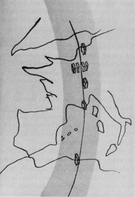
Figure 38.
Le Corbusier, sketch showing the unification of
the French colonial empire by urbansim.
axis, proposing to unify the greater France through a new architecture and urbanism. With such drawings, Le Corbusier was reiterating the notion of a geographical axis between France and Algiers, a repeated theme in colonial discourse. For example, Cotéreau, a prominent engineer who worked for the urban administration of Algiers, argued in 1933 that the city must be renovated by means of a "sane architecture, following Aryan traditions," because of "its position on the axis of France."[33] Le Corbusier's sketches depict, furthermore, the idea of la plus grande France , which represents not only an imperial French doctrine, but also a colonial consciousness developed in 1930. Minister of Colonies Paul Reynaud summarized this new mindset at the time: "Everyone among us must feel he is a citizen of the greatest France [la plus grande France ] that expands to five parts of the world."[34]
Le Corbusier's 1932 Obus A plan (the word obus being a reference to the trajectory of an exploding shell) ignored the existing city by and large and superimposed a new system. A curvilinear viaduct along the

Figure 39.
Le Corbusier's Obus A plan, 1932.
waterfront connected Hussein-Dey to St. Eugène, emphasizing the linear development of the city and reinterpreting the corniche in the Prost plan (Fig. 39).[35] Le corbusier's desire to respond to the geography of the site and to muster views of the Mediterranean was the driving factors behind his proposal; the viaduct (which would house working classes) can be regarded as a second, and raised, corniche running parallel to the first one, the Boulevard de l'Impératrice. The Marine Quarter, entirely demolished and transformed into a cité d'affaires , reflects a conceptual similarity to zone A of the Prost plan. Yet the scale is radically different, as Le Corbusier's scheme is dominated by high-rises. The housing blocks of Fort-l'Empereur on the hills, intended for the middle and upper classes, can be seen as the equivalent to the zoning of the heights of Mustafa for upper-class residences by Prost and his colleagues. The last major element of the plan, the elevated highway that connected the housing on the hills of Fort-l'Empereur with the business center in the Marine Quarter, addressed the much-debated problem of linking the coast to the heights—a problem that Prost and his colleagues had attempted to resolve by means of underground transportation.
Obus A was formally the most spectacular of Le Corbusier's Algiers plans. In successive plans, he modified the original scheme in accordance to the responses he received. In Obus B of 1933, for example, he eliminated the viaduct and gathered all the functions of the business center in a single skyscraper. Obus C of 1934 was restricted to the Marine Quarter only and again proposed a single skyscraper. This building
became the principal focus of the proposals and took different forms: in 1938 it acquired a Y-shaped plan (Obus D), and in 1939 it was transformed into a building whose facades were defined by Le Corbusier's hallmark brise soleils (Obus E).
The 1942 project was the last and the most conventional of Le Corbusier's schemes for Algiers. Although it came closest to Obus A in its scope as a master plan, it diverged dramatically from the proposal of 1932 in terms of its formal qualities. A coastal road replaced the viaduct, approaching closer to Prost's corniche, and zoning dominated the plan, delineating separate functions that were not connected to each other. The business center was moved from the Marine Quarter to the eastern end of Boulevard Laferrière, away from the casbah and clearly serving the European community. Similarly, the civic center was transported to Agha, again shifting the center toward the European town. Recreation facilities were placed along the coastline of Bab el-Oued and in the vicinity of the Jardin d'Essai; industry was concentrated in Hussein-Dey, and the port maintained its commercial and transportational functions. Residential zones, distinguished with their Y-shaped high-rises, dominated the hills, affording good views and providing for public gardens and parks. The Marine Quarter was now reserved for "Muslim cultural institutions," with the argument that this transformation would enable the cleaning of the lower part of the casbah and bring a new vitality to the casbah-Marine ensemble.[36] The separation between the European and indigenous communities would thus be secured even more firmly than in the previous schemes.
Le Corbusier's progression from Obus A to the plan directeur reflected the architect's persistent efforts to secure the commission by conforming to established norms. As argued by Mary McLeod, the architect's involvement with the landscape became limited to details and moved away from broad gestures that had endowed Obus A with its lyrical plasticity.[37] Not surprisingly, it is the more "realistic" aspects of Le Corbusier's later plans that made an impact on the future architecture of Algiers. While the Algiers plans have become keystones in the architectural discourse on modernism, their impact on the city of Algiers itself remained minimal. The most memorable urbanistic aspects on paper—the daring proposals of Obus A—were the least influential, whereas the plan directeur surfaced in small fragments now and then in subsequent efforts to regulate the city. Le Corbusier's influence on Algiers remained on the architectural level and manifested especially in the 1950s.[38]