
The Shortage of Land
Intensive settlement, as indicated above, has left the region's older cities with relatively little land that is easily available for development. Few large tracts of vacant land remain in the cities, except in the more isolated parts of Staten Island and in Newark's meadowlands. Most of the remaining undeveloped land is in small parcels that are difficult to use for large-scale development. Moreover, vacant land in the older cities has usually been bypassed for good reasons—often because of difficult terrain, which requires substantial grading, large amounts of fill, or expensive pilings. Undeveloped areas often lack sewers, streets, access to public transportation, and other improvements. As a result, much of the open land in the older cities is costly to build on, or inaccessible, or both.
The lack of usable vacant land has a number of important consequences for the politics of development in the older cities. It reduces the usefulness of zoning as a means of influencing development, since zoning tends to have its greatest impact when land is initially used. Moreover, the absence of easily developed land combines with intensive settlement patterns to drive up prices, which increases the costs of acquiring land in the older cities for public housing, industrial parks, highways, and every other public project. In addition, most city development programs involve land that is already being used, usually complicating government's role even more. In urban renewal, for example, city officials have to select areas for redevelopment, secure a private developer interested in using the site, acquire the land, relocate those using the property, resell land to the developer, and improve public facilities serving the area, all within the framework of detailed federal regulations.
Intensive development also increases the number of people affected and the degree of conflict, particularly for programs of urban renewal, highways, industrial development, and other activities that require large amounts of land. In the case of urban renewal, more people are disadvantaged by the clearance of densely populated slums than will benefit from the new dwelling units. The fact that very few residents of renewal areas can afford to live in the new buildings further exacerbates discord. Large-scale private development efforts in the older cities cause similar problems. For example, the expansion plans of Columbia University and other major institutions in the Morningside Heights section of Manhattan have been steadfastly opposed by local residents. From Columbia's perspective, "the problem was a physical one. It simply isn't possible for institutions to grow the way the institutions
feel we must grow and for the residents to remain here in the same number and location they are in now. Something has to give and a considerable number of people will have to move."[14] On Morningside Heights as elsewhere in the older cities, however, local residents refused to give in without fighting for their densely settled turf, and in the process successfully enlisted to their cause political leaders who were able to limit Columbia's expansion.[15]
Conflict over scarce land means that most major development activities in the older cities are plagued by long delays. An example is New York City's experience with the Flatlands Urban Industrial Park, the city's initial venture into industrial land development. First, local residents bitterly protested Mayor Wagner's plan to condemn the 96-acre site, and work on the project was delayed while the homeowners carried an unsuccessful legal action all the way to the U.S. Supreme Court. Then a struggle developed between the city and black groups that wanted the site developed as an educational park complex to foster integration. After years of controversy, instead of being covered by two million square feet of factories as envisaged by City Hall, Flatlands was "a glacier of mouldy mattresses, unsprung sofas, and a strange gamut of debris," populated by "rats . . . as big as cats."[16] When construction finally began in the middle of 1966, Mayor Lindsay was reminded of the intensity of competition for land in the city as he was met at Flatlands by 1,000 black and Puerto Rican demonstrators from Brooklyn's ghettos, who chanted "Industrial Park, No; Educational Park, Yes."[17]
Lindsay sought to mollify the Flatlands demonstrators by insisting that "we can do a lot of things at once. We can do this and still build more and better schools."[18] In fact, however, the scarcity of land in the older cities guarantees that industrial land acquisition will produce conflict. Implementation of Newark's $11 million industrial renewal project in the black Central Ward was delayed for years by the litigation of property owners and the protests of affected residents and their allies, who valued new housing more highly than job development in the renewal area. In New York City's 38-acre Washington Street Market urban renewal area, conflict arose between public agencies pursuing different development objectives. In line with the original plans to develop the Washington Street site for commercial and industrial use, the Public Development Corporation urged the construction of a center for the city's printing industry, which would help to keep the industry's 165,000 jobs in the city. The Housing and Development Administration, on
[14] Lawrence H. Chamberlain, vice-president, Columbia University, quoted in Steven V. Roberts, "Columbia's Expansion to Uproot Area Residents," New York Times, November 2, 1966.
[15] The major victory of local interests over Columbia involved a proposed gymnasium on a two-acre site in a city park that separates Columbia from Harlem. Announced in 1961 and initially supported by most city political leaders, the gymnasium was opposed by a broad coalition of neighborhood and minority interests, leading to second thoughts on the part of city officials, and the plan's ultimate withdrawal in 1969.
[16] Homer Bigart, "Industrial Park Spelled D-U-M-P," New York Times, March 30, 1966. Delays also were caused by difficulties in finding a suitable developer and differences over the project between the Wagner and Lindsay administrations.
[17] See Douglas Robinson, "Mayor Walks Alone into Angry Crowd and Draws Cheers," New York Times, July 20, 1966. Flatlands finally was opened in early 1969; for a useful review of these developments, see Joseph P. Fried, "Park Opens for Industry in Brooklyn," New York Times, January 12, 1969.
[18] Quoted in Robinson, "Mayor Walks Alone."
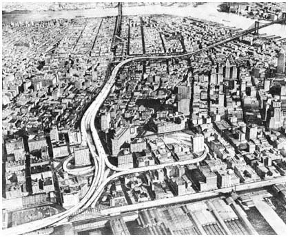
The route of the Lower Manhattan Expressway
as proposed by Robert Moses.
Credit: Triborough Bridge and Tunnel Authority
the other hand, argued for comprehensive development in the area, including public housing and educational facilities. As with other development projects, conflict caused delays, compounded in this instance because federal and state approvals were required for a change in land use for an urban renewal site.
Nowhere is the impact of scarce land on the politics of development in the older cities more striking than in the case of road building. Highway construction in densely settled sections of the core adversely affects far more people than in the suburbs. A single mile of Robert Moses's Cross-Bronx Expressway demolished 1,530 dwelling units in the East Tremont section of the Bronx.[19] The Lower Manhattan Expressway, another major highway designed by Robert Moses in his capacity as New York's City Construction Coordinator, would if built have displaced 2,000 families and 800 businesses with 10,000 employees along a 2.5-mile corridor between the Holland Tunnel and the Brooklyn Bridge.
As the implications of urban expressways for local neighborhoods were grasped by city dwellers, highway plans met increasingly fierce opposition in the region's core. A lengthening list of projects were shelved in the late 1960s
[19] For an excellent discussion of the routing of the Cross-Bronx Expressway through East Tremont, see Robert A. Caro, The Power Broker: Robert Moses and the Fall of New York (New York: Knopf, 1974), Chapters 37–38.
and 1970s in the face of intense resistance from local interests and responsive public officials. Successful opposition to the new roads developed sooner in densely settled sections of the cities than in the suburbs, and depended less on the environmental factors discussed in Chapter Four, although antihighway groups in the older cities were quick to capitalize on environmental considerations when ecological concerns moved to the forefront of the debate over road-building in the early 1970s.
The first major casualty among inner-city highways was the Lower Manhattan Expressway. Despite impressive support from downtown business interests, and substantial political backing from City Hall prior to the election of John Lindsay in 1965, the Lower Manhattan Expressway could not survive prolonged and well-organized opposition from residents of the area. First the opponents prevented the construction of the highway for over a decade, then they forced the city to redesign the road as a partially depressed expressway, and finally they persuaded Mayor Lindsay to abandon the project in 1969. The years of controversy and uncertainty also delayed implementation of urban renewal, middle-income and public housing, and other public and private projects in areas adjacent to the stillborn expressway.
In Newark, the Midtown Connector aroused the same kinds of passions as the Lower Manhattan Expressway, with the added element of racial conflict intensifying feelings in the racially divided city. Designed to connect two highways that flanked the city—Interstate 78 and Interstate 280—the 2.5 miles of road were to cut through Newark's black Central Ward, in the process eliminating almost 3,000 residential units housing 10,000 low-income blacks. Initially, the expressway was strongly supported by the city's business and political leaders, who saw the road as a means of relieving congestion, fostering economic growth, and eliminating slums. In promoting the project, Mayor Hugh J. Addonizio emphasized "the benefits Newark will derive from this undertaking," as well as "the necessity" of the road "as part of a large regional transportation network."[20] Opposition began in the affected black neighborhoods, with community, antipoverty, and church groups in the forefront. Other black interests joined in the struggle, including militant organizations like the Black Panthers. By 1970, protests against the road had escalated to the point where city leaders feared a replay of Newark's 1967 revolt, which had been triggered by black anger over the proposed clearance of a large site in the Central Ward for the construction of a state medical school.[21] Facing the prospect of another devastating conflict, city officials reluctantly capitulated to community pressure. As one explained, we "want the road, but we don't want the issue . . . [W]e're not antihighway, but we are anti-confrontation."[22]
Among other major road projects killed by the intensity of opposition in the land-scarce older cities were the Mid-Manhattan Expressway, the Bush-
[20] Quoted in Moray Epstein, "Rt. 75 Line Gets Airing," Newark News, February 28, 1964.
[21] The medical school proposal, community opposition, and the black revolt are discussed in Chapter Nine.
[22] See Douglas Eldridge, "Confidential Report Ready on Rt. 75 Plan," Newark News, February 15, 1970.
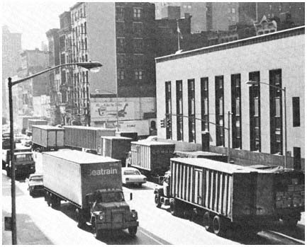
Trucks inch their way across Canal Street in the
transportation corridor that would have been
served by the Lower Manhattan Expressway.
Most of the buildings in the photo would have been
demolished to make way for the highway.
Credit: Louis B. Schlivek, Regional Plan Association
wick Expressway in Brooklyn, and the Cross-Brooklyn Expressway.[23] The Cross-Brooklyn road, which was to link the Narrows Bridge with the Nassau Expressway near Kennedy Airport, was the heart of an ambitious "linear city" scheme designed by the Lindsay administration, involving a six-mile strip of new housing, schools and other public facilities, and with commercial and industrial development to be built over the road. The attempt to market the expressway as part of a comprehensive plan intensified rather than reduced opposition, however, since even more land would be taken for the entire plan than for the road alone. Responding to widespread local opposition, legislators from Brooklyn killed the project in Albany. "The people in Brooklyn are up in arms," explained one of the borough's most influential political leaders, because "the Mayor wants to run an expressway through the heart of the residential area of Brooklyn."[24]
[23] The Mid-Manhattan Expressway, joining the Lincoln Tunnel and the Queens-Midtown Tunnel, was part of Moses's plan for several elevated highways across Manhattan. The Bushwick Expressway was another Moses project, and was designed to link the Williamsburg Bridge with the Nassau Expressway. Responding to local opposition to the Bushwick road, the Lindsay administration replaced it with the equally unpopular Cross-Brooklyn Expressway.
[24] Assemblyman Stanley Steingut, quoted in Maurice Carroll, "Plans for Brooklyn RoadHalted by Mayor's Order," New York Times, March 4, 1969. Steingut was the leader of the Democratic Party in Brooklyn, and minority leader of the New York State Assembly at the time; his successful effort to block Lindsay's scheme was supported by every member of the state legislature from the borough.
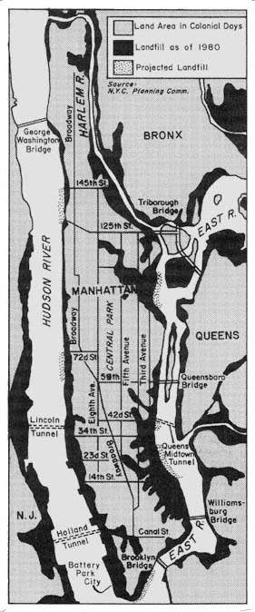
Landfill: Manhattan
and Adjacent Areas
Map 10
One way around some of the problems resulting from the shortage of turf in the older cities is the creation of new land. Over the decades, new land has been formed on both sides of the Hudson by fill and other means, as indicated by Map 10. About 3,650 acres have been added to Manhattan since the city's founding, and land reclaimed from the surrounding waters now accounts for about 25 percent of the island's area. Extensive reclamation has been necessary in the development of marine terminal areas in Newark and Elizabeth. With the growing scarcity of land, its high cost, the problems of relocating residents and businesses, and the intensity of pressures that confront efforts to change existing land uses, the creation of new land has become increasingly attractive to leaders in the older cities. "We're adding more land by means of platform development to lower Manhattan," explained Mayor Lindsay in connection with his ambitious plans for the eastern tip of Manhattan, "because we're not satisfied with the size of the island we bought."[25]
Creating new land, however, does not eliminate conflict. The very scarcity of land in the older cities almost always leads to disagreements over the use of newly formed acreage, as illustrated by the competing plans of New York City and New York State for 91 acres along the Hudson River created in the construction of the Port Authority's World Trade Center. City Hall saw the parcel as an integral part of its comprehensive and imaginative $2 billion plan for lower Manhattan. The state government wanted to develop the site as a $600 million free-standing project called Battery Park City, containing housing, office, commercial, and industrial development. Only after two years of disputes and hard bargaining did a compromise emerge, which retained the state's Battery Park concept, but reframed the project to comply with the city's general plan for lower Manhattan.
Particularly contentious has been the question of what kind of housing should be built on new land. In the case of Battery Park City, the state advocated a mix of housing to serve a broad range of income groups, while New York City favored heavy emphasis on luxury units, because of the high cost of reclaimed land and its desire to complement downtown office development with walk-to-work housing for executives. In the negotiations over the Battery Park project, the city's views on housing prevailed. Less than 7 percent of the project's units were to be for low-income families, and even this commitment disturbed Mayor Lindsay, who saw it as "equivalent to putting low-income housing in the middle of the East Side of Manhattan."[26] Lindsay's position was strongly criticized by black leaders and spokesmen for low-income groups, who assailed the city for using public money to house the rich in "the Riviera of the Hudson" while housing conditions for
[25] Quoted in David K. Shipler, "Massive Complex Planned for Platform in East River," New York Times, April 13, 1972.
[26] Quoted in David K. Shipler, "Battery Park Plan Is Shown," New York Times, April 17, 1969. Because of the high costs of landfill a unit of low-income housing in Battery Park City was about 2.5 times as expensive as the average unit constructed elsewhere in the city.
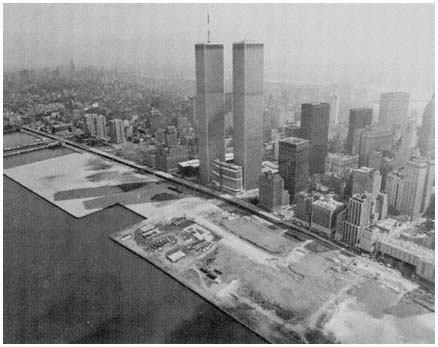
New land created from the excavation of the
World Trade Center will be the site of the
Battery Park City development.
Credit: Port Authority of New York and New Jersey
the poor deteriorated.[27] A similar dispute arose over the housing mix in the city's Waterside development, involving 1,450 apartments constructed on a six-acre platform over the East River. The controversy combined with financial problems to delay the project for years, before critics were mollified by an increase in the proportion of low- and middle-income apartments.