From the Needle's Eye to the Hermit's Garden
Climbing is easier near the top of the chimney where the central rock develops into well-defined steps (Fig. 20). The climber stepping out of the Needle's Eye discovers the first of several perplexing structures on the South Peak. Two crescent-shaped masonry platforms (see Fig. 57) were built here, one slightly higher than the other, that have no connection with the climb to the top. Possibly the monks used them as construction platforms, level areas on which to pile building materials brought up the chimney by rope.[2]
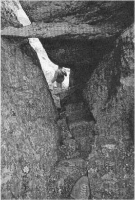
Fig. 20
Skellig Michael, South Peak. The Needle's Eye.
View down the shaft from the last of the four
steps cut into the inner wall of the chimney
above the spine of rock shown in Figure 19.
Photograph by Walter Horn.
The remains of another odd structure lie nearby, separated from the trail leading to the top and visible only from above. On the far side of the Needle's Eye are the remains of a small U-shaped enclosure built on a level spur facing west to the sea (Fig. 21). Access is awkward, requiring a scramble up and over the large rock that is the west side of the Needle's Eye. This time no helpful handholds or toeholds mark the way.
[2] After negotiating the chimney, the climber steps onto the lower of these platforms (not visible in photographs), which extends almost 4 meters. Up three rock-cut steps is the second platform, which runs for 7 meters, ending abruptly at a rock face. Another possible reason for their construction may have been the need for access to areas for bird hunting on the north side of the peak.
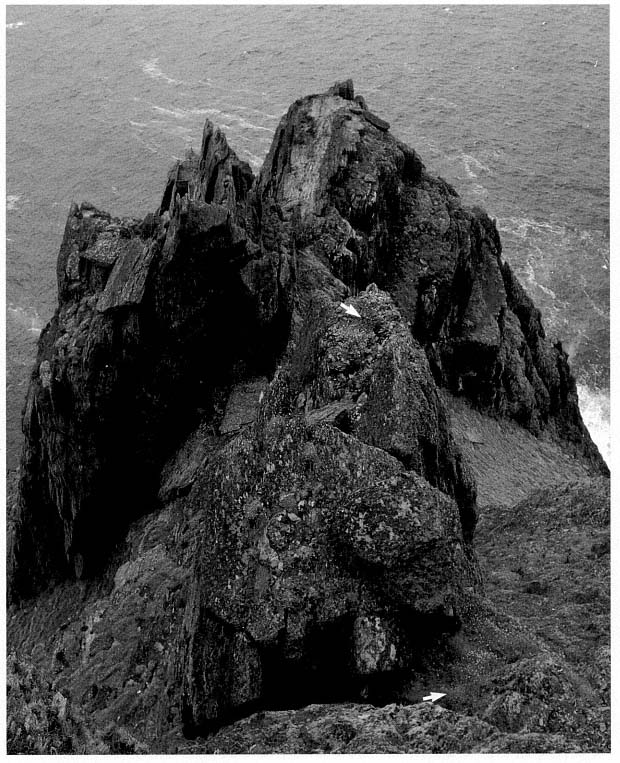
Fig. 21
Skellig Michael, South Peak. The rectangular masonry enclosure (upper arrow) at the outer edge of the
Needle's Eye. The exit from the Needle's Eye is at the lower arrow, and in the background, at left,
are the ruins of the Upper Lighthouse.
Photograph by Walter Horn.
The inside of the enclosure is about 2.3 meters long and 1.2 meters wide; the wall varies in thickness from .35 to .50 meter (Fig. 22). Although the enclosure wall now is rather low, with stone rubble filling the interior, it is still possible to trace both the inside and the outside except at the entry and externally at the southwestern corner, where it has fallen away. The masonry, of fairly small-sized stones, is difficult to judge, but the scale and technique of construction are those of a rectilinear enclosure wall, not those of the base of a cell. Judging from the amount of fallen stone and taking into consideration stone that has fallen over the edge, we calculate that the original wall may have been from 1 meter to 1.5 meters high.
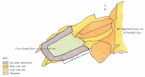
Fig. 22
Skellig Michael, South Peak. Drawing by Grellan Rourke of the small enclosure near the Needle's
Eye, based on the 1986 survey of the hermitage by Grellan Rourke and Richard Stapleton.
A short length of wax candle and a fragment of a rude stone cross, identical to crosses in the monastery graveyard, lay under collapsed stone in the enclosure (Fig. 23). Was this a place for a hermit to pray and meditate?
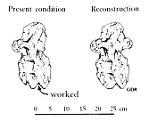
Fig. 23
Skellig Michael, South Peak.
Fragment of a cross found in the
small enclosure.
Drawing by Grellan Rourke.
After the detour to the enclosure, the climber returns to the trail above the Needle's Eye and continues to ascend, making a sharp turn to the right. The next task is scaling a rough-textured rock gully nearly fifteen meters high (see Figs. 12, 13). Here again progress is aided by toeholds, although these are not always easy to recognize because plants, also seeking a foothold on the irregular surface, fill the crevices of the gully.
At the top of the gully the climber finds, in a narrow rock cleft (Fig. 24), masonry steps that lead to the first and lowest of the three hermitage stations, one that has never before been recognized and is nowhere mentioned in the accounts of previous visitors to the site (Fig. 25).[3] The reason for this omission is simple: the climber stepping onto this terrace with surprise and relief cannot see that it has been constructed. The walls holding the terrace in place, invisible to anyone ascending the gully to the terrace or standing on it, can be seen only if one leans far over the edge, something few visitors would think of doing.
[3] The cleft has been artificially widened; at least .5 square meter was removed (presumably by the monks) from the western, entrance, side to facilitate access to the terrace (O'Sullivan 1987).
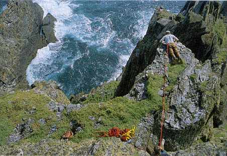
Fig. 24
Skellig Michael, South Peak. The garden terrace from above. The narrow rock
cleft that provides access to the terrace is at the lower right. Paddy O'Leary (top),
secured by a rope held by Lee Snodgrass, examines the retaining wall.
Photograph by Walter Horn.
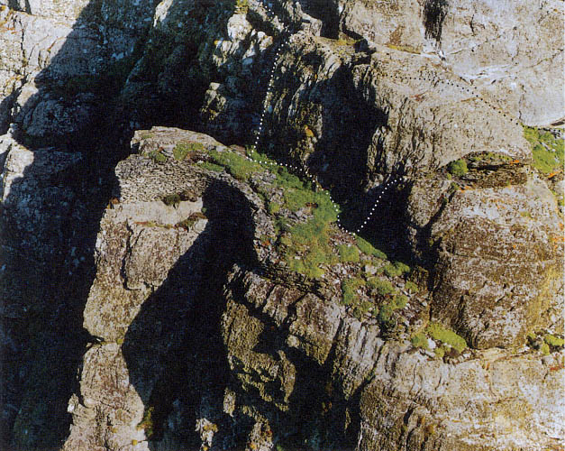
Fig. 25
Skellig Michael, South Peak. Aerial view of the garden terrace. Photograph taken in 1987 by Con Brogan.
Courtesy Office of Public Works. Dotted lines indicate the two passages to the oratory terrace, the upper
one over the hump of rock that separates the two terraces, the lower one around its outer face.
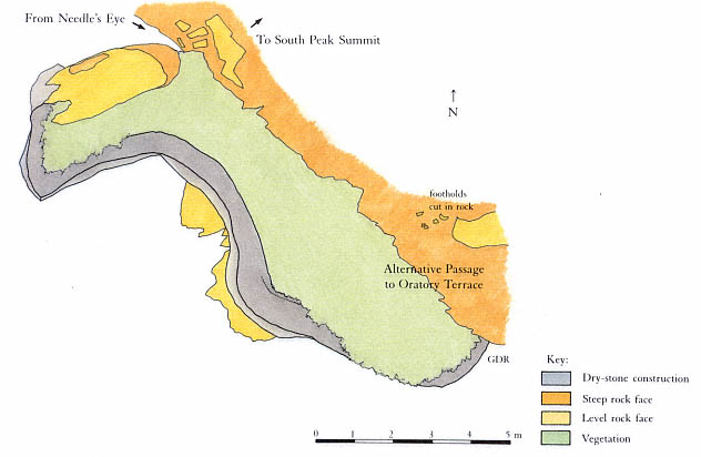
Fig. 26
Skellig Michael, South Peak. Plan of the garden terrace by Grellan Rourke, based on the plane-table survey of 1986
made by John O'Brien and Grellan Rourke, assisted by Aidan Forde of the Kerry Mountain Rescue Team.
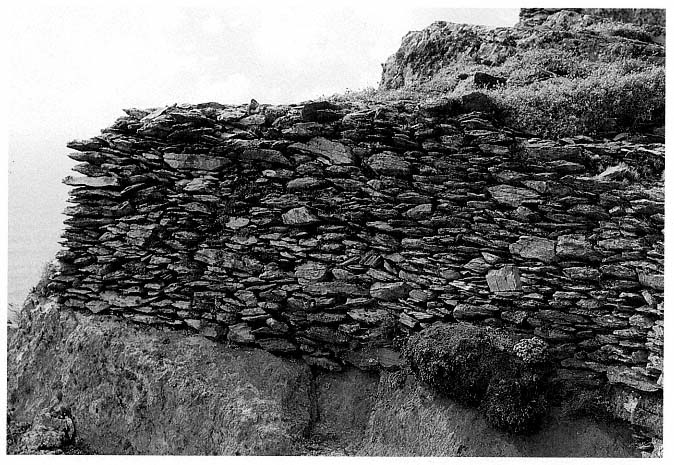
Fig. 27
Skellig Michael, South Peak. Garden terrace. Northwestern end of the retaining wall built on a solid ledge of bedrock
and therefore still in excellent condition.
Photograph by Walter Horn.