Réunion Island in the Indian Ocean
The geothermal drilling project on the Island of Réunion in the western Indian Ocean provides an example of where one might not expect to find a hydrothermal system. Piton de la Fournaise, an active basaltic shield volcano on Réunion, was constructed on the southeast flank of an older shield volcano, Piton de Neiges. Fournaise has erupted about every 2 years during the last 250 years (Stieltjes, 1985). Broadly curving faults define a series of large blocks stepping down to the sea (Fig. 6.22); these features were interpreted by Stieltjes (1985) as a caldera and by Duffield et al . (1982) as large gravitational slumps. The faults flank a
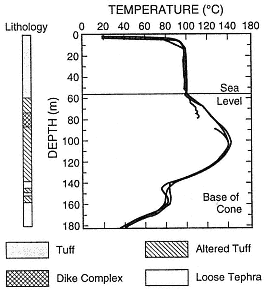
Fig. 6.20
Temperature profiles and simplified lithologic
descriptions for the Surtsey borehole. Excess
heat encountered at ~80-m depth is probably
related to a 13-m-thick dike
complex in the core of the cone.
(Adapted from Jakobsson and Moore, 1982.)
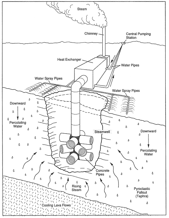
Fig. 6.21
Diagram of the emplacement of shallow collectors (steamwells) in scoria deposits overlying a thick
basaltic lava flow from the 1973 eruption of Heimaey, Iceland. Water from surface pipes supplies
the recharge to the solidified, fractured lava flow, where steam is generated and collected in
a steamwell. This geothermal energy source is
successfully operating as a district-heating system.
(Adapted from Björnsson, 1980, and Williams and Moore, 1983.)
broad trough that slopes from the summit elevation of 2600 m to sea level. Kieffer et al . (1977), Duffield et al . (1982), and Stieltjes (1985) propose that the rift zones trend northeast, southeast, and northwest. Historic eruptions have occurred at vents in the summit caldera and along the flanking rifts. The Cratère Bory and Cratère Brûlant form a 1.2- by 0.7-km summit crater complex.
Two geothermal wells have been drilled on Réunion Island. One was sited on the east coast, in the outflow area of Piton de la Fournaise and the other on the older Piton des Neiges volcano. The Fournaise well, drilled on the shield flanks—inexplicably away from the active rifts—reached bottom in a dense gabbro intrusion and was cold. The second well reached rock at temperatures of 200°C but did not produce any fluids.
Geothermal heat sources in basaltic volcanoes rely on frequent but small eruptions. In contrast, along convergent plate boundaries and on the continents, eruptions are less frequent, but heat sources are shallow and large. Chapter 7 discusses the most common volcano type found at these convergent margins—composite cones.
Fig. 6.22
Piton de la Fournaise on Réunion Island in the Indian Ocean.
(a) Map of Piton de La Fournaise volcano Shaded areas indicate rift zones.
(Adapted from Duffield et al., 1982).
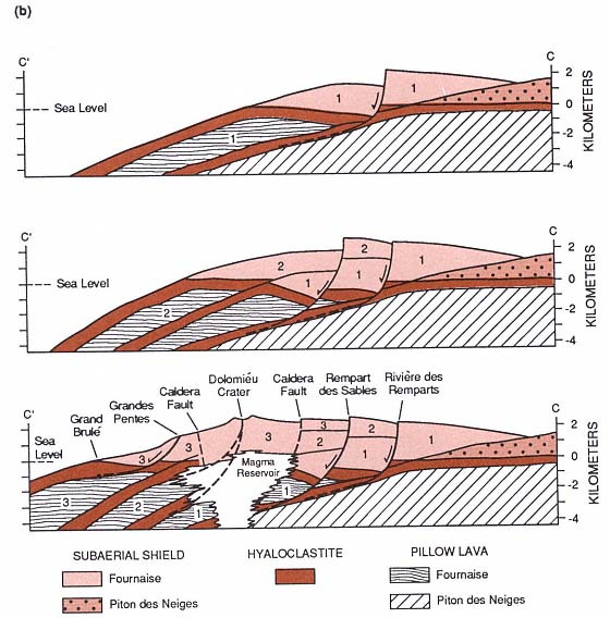
Fig. 6.22
(b) Diagrammatic cross-section C'—C. Features noted 1, 2, 3 refer to major periods of eruptive
activity. Gravity slump blocks from earlier stages are believed to be bounded by formerly active pairs
of northeast and southeast rift zones. A possible future slump block, shown with dashed line,
is located below fracture systems of the presently active rifts.
The position of the magma reservoir is speculative
(Adapted from Duffield et al., 1982).