PART II—
SEVEN TOWNS
The first part of this book has studied the course of royal policy toward agriculture in the second half of the eighteenth century. It observed the failure of Carlos III's attempts to increase the number of small farmers and the modifications in the philosophy of agricultural reform and the demands of the royal fisc that culminated in the disentail of ecclesiastical properties under Carlos IV. The second part aims to be a parallel study of the evolution of rural society and agriculture at the local level. Its subject is seven communities in the provinces of Salamanca and Jaén, two provinces in distinct parts of Castile that experienced high levels of disentail. In each community it will analyze the farming patterns, the social structure, the level of income of the communities as a whole and of the occupational sectors within them, the economic relations with the outside world and their effect on local conditions, and the power structures. When possible, it will indicate the direction of evolution, especially of the population, the agricultural patterns, and income. For each community it will then observe the process of desamortización and relate it to prior conditions and current developments. This part thus proposes to describe, in these individual cases, the local reality that royal policy sought to improve and the effect on the local reality of the execution of the royal decrees. One may then form some judgment of the accuracy of the perceptions of the king's counselors and of the wisdom of their policies. The developments in seven towns can also suggest conclusions on the wider evolution of Spanish agriculture and rural society at the end of the old regime. These conclusions can be put to more general
tests in Part 3, which deals with the provinces of Salamanca and Jaén as a whole.
Within these provinces, I selected for detailed study rural communities in which the Madrid records show that there were numerous sales and for which the provincial archives have full or nearly full records. The two major sources at this level are the catastro, or survey of individual and institutional property and personal income, executed in the provinces of Castile in the 1750s under the direction of the Marqués de la Ensenada and the archives of the contadurías de hipotecas founded by Carlos III in 1768.
Undertaken to make possible the substitution of a single tax on income to replace the complex tax structure of Castile inherited from the Middle Ages and the Habsburg era, the catastro is one of the most extensive sources in existence for social history in the early modern period. Its basic feature is a series of town-by-town surveys conducted under the guidance of royal agents. Where preserved these town surveys are bound in volumes, with several volumes for each place unless it was tiny.[1] The first part, known as the respuestas generales or autos generales, consists of answers to forty questions covering the geographic limits of the town; the number and kinds of buildings; the crops raised and their average price; the different qualities of land in the town and their average yield; the income from livestock, forests, and other natural resources; the amount of tithes, seigneurial dues, royal taxes, and other impositions on the town; and the number of people engaged in each kind of occupation, with their daily wage or annual income. This part is followed by the libro personal de legos and the libro personal de eclesiásticos. These are lists of all the individuals in each household, the first of laymen and the second of households headed by an ecclesiastic. They provide the name and occupation of the heads of household (male or female) and a list of all others in the household with their relationship to the head of household. Frequently all personal names are given and the ages of all males. Much miscellaneous information is also preserved in these volumes, but it varies from town to town. They are invaluable sources for studying family size and structure and its relation to social class and occupation. The third main part of each town's catastro, the most extensive, is formed by the libro maestro seglar and the libro maestro eclesiástico. These give household-by-household and institu-
[1] See Matilla, Única contribución, 77 n. 64, for a list of those provinces where the volumes are in existence. It records Jaén as missing, but this is incorrect; most of the volumes are available.
tion-by-institution surveys of all the property, real and animal, in the town. They give the name and occupation of the owner, followed by his livestock (pigs, sheep, goats, and larger animals, not dogs, chickens, and small animals), his houses, and his fields. Individual income from official positions, professions, and commerce is also listed, but not from daily wages and sale of the products of handicrafts (the latter information appears in the respuestas generales). Real properties are identified by their location within the town limits (property that the vecinos owned in other towns would be listed in their catastros) with the names of owners of adjoining properties, number of rooms and size of buildings, extent and quality of fields, number of trees in orchards, and so forth. Municipal and ecclesiastical properties are surveyed in equal detail (the latter in separate volumes), and the volumes can be hundreds of folios long.
The planners of the catastro took pains to keep the records of lay property (including municipal property) separate from those of ecclesiastical property. The latter records served the crown well when Carlos IV began the disentail of the endowments of obras pías. They are also useful to the historian, for they make possible the identification of the properties sold and their place in the economy of the town. Furthermore, they can be presumed to be fairly accurate, because the volumes were read aloud at town meetings that often lasted more than a full day and were then certified as correct by the leading vecinos. It would have been difficult for any privileged person to falsify his record unless he had the town completely under his thumb. In only a few cases have I found properties sold that do not appear in the catastro.
The other main source at the provincial level is the records of the contadurías de hipotecas. By a pragmatic sanction of 1768, Carlos III ordered each cabeza de partido to establish an oficio de hipotecas under the charge of the notary of the municipal council. It was to keep a record of transfers of real property and liens on property. These offices later became known as contadurías de hipotecas. In the nineteenth century their name changed to registros de propiedad, as they are known today. From my experience, as late as 1969 the registry of sales or transfers of property with these offices was voluntary, and the archives indicate that the contadurías were not very active until the beginning of disentail, when they were ordered to record the sales. Most of their records from 1799 to 1808 concern the disentail. The registros de propiedad took over their records, and recently care of them has been assigned to the provincial historical archives.
Not all their records have been preserved in either Jaén or Salamanca
province, but those that do exist give vital information for the study of the process of disentail under Carlos IV at the local level. They furnish synopses of the notaries' records of sales, providing the name and domicile of the former owner and the buyer and a description of the property that usually makes possible its identification in the catastro. Information that is vague or incomplete in the Madrid records is here specific. Furthermore, the records are kept by town; thus they make relatively rapid a process that would be almost interminable if one had to search for the original deeds of sale of a certain town in the records of all the notaries who might have executed them, even if none of them had been lost. Unfortunately, some buyers were lax about registering their titles, so that there is no assurance that the contadurías provide a complete record of sales of any one town. Sales turn up in the Madrid archive that they do not list; nevertheless, without them it would be very difficult to recreate the process of disentail at the town level.
Finally, when they are available, one of the most valuable sources for information on local economic activity is the parish tithe rolls. In the second half of the eighteenth century, the prelates of Salamanca began to require the parish tithe collectors (cilleros ) to keep accounts of the payments made by each farmer, instead of noting only the total of the various crops collected in the parish each year, as had been the prevailing practice. This reform lets us see not only how many people were farming in a town but how much each one harvested. We can draw an economic pyramid of the farmers and locate in it those persons who bought property in the disentail. Unfortunately few parish tithe rolls (tazmías ) seem to have been preserved, and those that have been are hard to locate since they are uncatalogued in the shelves of the village churches or the homes of the incumbent priests. Two were already known in Salamanca province, those of La Mata and Villaverde, both close to the capital, and an extensive search on my part through the south of the province unearthed a third, in El Mirón (today in Ávila province). I chose these three towns to study because of the completeness of the information on them. I selected a fourth, the rural estate of Pedrollén, as an example of a different kind of region and community.
In Jaén province, as probably in most of Andalusia, where parishes were large, the ecclesiastical authorities farmed out the collection of tithes to private individuals. These tithe farmers (administradores ) contracted to pay fixed amounts of money or crops to the religious institutions entitled to receive the tithes and collected the payments due from the farmers, keeping as their profit the difference between what they col-
lected and what they paid. In bad years their profit could turn to loss, and they had to demonstrate in bidding for the contract that they had the financial resources to be able to absorb losses. What accounts may have been kept of payments by individual farmers were in the hands of the administradores and have most likely been lost or destroyed. I found no trace of any and therefore I selected three towns in different parts of the province for which we have catastro and contaduría records, where a considerable amount of land was disentailed and which were not too large to be manageable. They are Baños, Lopera, and Navas de San Esteban del Puerto.
These seven rural communities run the gamut from a large estate through small villages to a town of nearly two thousand people. For simplicity I refer to them all as towns, begging the indulgence of sticklers for definitional accuracy. Let us turn first to the towns of Salamanca, which are smaller than those of Jaén and for which I have fuller information.
Chapter VII—
La Mata
The city of Salamanca is built on a group of low hills on the northern bank of the Rio Tormes some distance upstream from its confluence with the Rio Duero. The Duero is the major river of the northern meseta, and the Tormes is its main tributary from the south, bringing waters from the northern slope of the massive Sierra de Gredos. An impressive Roman bridge of twenty-six stone arches crosses the Tormes at Salamanca, a witness both to the volume of the river at its height and the secular importance of the city as the center of a rich agricultural region.
The urban skyline stands out above the valley, marked by the two cathedrals, the new one of the sixteenth century with the older Romanesque one tucked in its shadow, and the numerous convents and parish churches, so many that Salamanca has been known familiarly as Little Rome. Lying lower and less visible are the buildings of the university and associated colleges, mainly of the Renaissance. Under Felipe V, a more worldly age, the heart of the city was torn out to create the Plaza Mayor, a large open square surrounded by a four-storied building with arcades and shops on the street level and apartments above. The city hall dominates its northern side. The Plaza Mayor is a beautiful example of early modern city planning and a reflection of the wealth pouring into the metropolis in the eighteenth century, for it rivals the older Plaza Mayor of Madrid in size and surpasses it in elegance.
Behind the eighteenth-century limits of the city is a rise; over the top of it stretches to the north a broad, gently rolling plain marked by the beds of a few streams and an occasional low hill. The plain of La Ar-
muña is one of the richest grain regions in dry Spain, characterized by thick, red soil that can be plowed deeply and holds its moisture when regions of thinner cover have dried up. In the eighteenth century many nucleated villages dotted the plain, as they still do today. They lie only three or four kilometers from each other, so that the view from any of the low rises includes a number of distinct settlements, each surrounded by wheat fields, green and lush in the spring, brown and dry after the summer harvest. Communication by cart was easy from town to town and into the city.[1]
Near the center of the plain, at an altitude of 818 meters, lies the village of La Mata, about twelve kilometers due north of Salamanca. Like most of the villages of the region, in the eighteenth century it was classed as a lugar, the lowest administrative entity with its own government. Approaching La Mata one saw first a stocky granite church sitting on a slight knoll in the middle of undulating fields. The church was squat and simple, lacking the square stone tower that decorated those in neighboring villages and suggesting that this community might be less wealthy than its neighbors. Around the church and running down the gentle gradient to the southwest were the public buildings and the low stone houses of the townsmen. The casa consistorial, or town hall, faced a small square below the church and held also the town jail. In addition the town council possessed a butcher shop and a smithy, which it rented out, and a storehouse that was used as the town granary (pósito). La Mata had sixty inhabited houses and two others that were empty, thirteen barns (pajares ), eight corrals, and two more granaries (paneras ), which belonged to the church and stored the product of the tithes. In one of the houses a vecino ran a tavern, where he sold wine and a few groceries.[2]
La Mata had a population of somewhat more than two hundred. According to the catastro, fifty-nine of these, including ten widows, were vecinos or heads of household. Twenty-two vecinos, including two widows, one-third of the total, made their living from farming. Twenty-three were arrieros, muleteers who transported goods for hire. A linen weaver, a shoemaker, the tavernkeeper, a schoolmaster, a surgeon-bloodletter, and the parish priest were the remaining male vecinos,
[1] For a fuller description of the geography of La Armuña, see Chapter 17 and Appendix Q.
[2] AHPS, Catastro, La Mata, libro 1421, resp. gen. QQ 22, 23, 29; libro 1419, maest. ecles., ff. 8, 48.
| |||||||||||||||||||||||||||||||||||||||||||||||||||||||||||||||||||||||||||||||||||||||
while the other eight widows had no specified means of support (Table 7.1 and Figure 7.1).
The término, or area of the town, was small; only half a league from east to west and three-eighths from north to south was what the vecinos reported to the makers of the catastro.[3] From the top of the knoll they could see similar towns in all directions. To the east La Mata bordered
[3] La Mata, resp. gen. Q 3. A legua was traditionally the distance covered in an hour's walk, about five kilometers.
Figure 7.1.
La Mata, Employment Structure, 1753
on Carbajosa de Armuña and to the west on Castellanos de Villiguera. Slightly further to the south was Monterrubio, at the foot of the small reddish hill that gave it its name, and to the northeast the twin towns of Palencia de Negrilla and Negrilla de Palencia, hardly a stone's throw apart. In addition, La Mata bordered on three despoblados or alquerías (the terms meaning literally "depopulated place" and "grange" were used almost interchangeably and indicated that a caretaker, a herder, and a few others might live there, but probably not the owner): Narros de Valdunciel on the northwest and Aldealama and Mozodiel del Camino on the south.[4] These occupied poorer land, some of it good only for grazing. So flat is the terrain, despite its gentle roll, that, even today, on clear days the vecinos of La Mata see La Peña de Francia, a sharp mountain on the southern border of the province, seventy-five kilometers away (see Map 7.1).
The catastro, dated 1753, and the register of tithe payments at the end of the century permit the reconstruction of the economic and social
[4] Ibid. Q 2.

Map 7.1.
La Mata and Its Environs
structure of this small rural community.[5] It is convenient to determine first insofar as possible the income of the different households and the total income of the village. With this economic profile before us, we can then observe how this society was evolving in the second half of the eighteenth century and what impact the disentail of Carlos IV had on the course of its development.
The makers of the catastro recorded the area of La Mata outside the town nucleus as 1,073 fanegas (480 hectares).[6] This is about 18 fanegas
[5] For the tithe records, see Archivo Parroquial, La Mata. I was able to copy this record thanks to the hospitality of the late parish priest, don Jerónimo Pablos, who made me welcome in his house for some ten afternoons in 1964 and 1969. This venerable gentleman also told me much about the town itself and the Armuña district. The pleasure of such interchanges is one of the unsung perquisites of the historian's craft.
[6] This is the total given at the beginning of maest. segl. La Mata, resp. gen. Q 10, says 1,100 fanegas but is less accurate. The local fanega was 400 estadales of 16 square varas each, or .447 hectares 1.13 acres) (ibid. Q 9). See Cabo Alonso, "La Armuña," 113.
for each of its vecinos, far below the Armuña regional average of 48 fanegas per vecino.[7] The fertility of La Mata's land, however, compensated partially for what it lacked in extent. The catastro's estimate of the productivity of the land in La Mata averages out at an annual return of forty reales per fanega. This is well above the regional average of twenty-seven; only five towns in La Armuña had more valuable land, and La Armuña was the richest district in the province. The value of La Mata's soil lay in its ability to produce first-class wheat, trigo candeal. Ninety-one percent of the término was wheat land (sembradura de secano que produce trigo ), 3 percent was devoted to rye (centeno ), and the rest was meadow (prados de secano para pasto ). None of the land in the town was barren or waste. Furthermore, both wheat and rye fields were sown every other year, whereas in most parts of arid Spain the land could produce a crop only once every three years or less often. The meadows were mowed for hay every year. Few towns in arid Spain could match the fertility of La Mata's soil.
The término was divided into many plots, very irregular in shape, scattered higgledy-piggledy across the rolling fields. The biggest plots were one of nine fanegas (four hectares) belonging to the town council and one of eight fanegas of the parish church. Altogether the catastro listed 551 arable plots and 33 meadows, which means that the average size of the first was under two fanegas and of the second hardly one. The larger holdings did not consist of larger plots but only of a greater number of them. As was common practice under such a system, the término was divided into several large fields (hojas ), and all the plots in each field were sown and harvested in the same year. In the late spring, the landscape of La Mata and its region would alternate between large patches of rippling green and others of fallow red and brown earth.
The scene had not always been so neat. Records preserved from earlier times suggest that prior to the population expansion of the late fifteenth and sixteenth centuries, when much of the region was still waste and available for pasture, farmers planted and harvested their individual plots as they wished. As more of the land of a community was put under the plow, an arrangement had to be made to feed the livestock: draft animals and sheep, both essential to the local economy. The solu-
[7] The data on the Armuña region refer to one of the geographic zones into which I divided the province for analysis (see Appendix Q). The data come from an analysis of the provincial returns of the catastro, AHN, Hac., Catastro, Salamanca, libros 7476, 7477, 7478, in each volume under letra D, "Producto de cada medida de tierra en reales de vellón."
| ||||||||||||||||||||||||||||||||||||||||||||||||||||||||||||||||||
tion in the fertile grain regions of Castile, which could produce wheat regularly, was to establish large fields within each término, alternating between a year of grain and another of fallow, half the fields in one cycle and half in the other. After the summer wheat harvest, the fields would lie untilled through the winter, and the animals would pasture on the stubble (rastrojo ) and weeds. Fallow plowing followed in the spring, to renew the soil and retard evaporation, until time for the autumn sowing of the next wheat crop. Henceforth all farmers of a village had to follow the same pattern, called familiarly año y vez, but each farmer needed to have plots scattered through all the hojas in order to equalize his harvest.[8]
The information in the catastro provides an easy estimate of the annual harvest of La Mata, since it includes the number of fanegas there were of each quality of land and the size of crop each quality produced annually per fanega. The latter figure was obtained by halving the expected harvest because each plot was sown only every other year (Table 7.2). These figures can hardly be expected to be exact. The makers of the catastro did not survey the plots but had to accept the best estimate of their size, and it was a matter of judgment into what class of land they
[8] García Fernández, "Champs ouverts," 705–9.
assigned each plot, since there was a continuum in the quality of the soil from the poorest to the best.
A more reliable measure of the harvests is provided by the tithes (diezmos ) reported in the catastro for the five-year period ending in 1752. In describing the different plots, the catastro defined them as being planted in either wheat or rye, but in fact the tithe returns show that the farmers also planted other crops, barley, oats, algarrobas (carob beans), and garbanzos (chick-peas). The farmers paid one-tenth of their harvest of all these crops as tithes.[9]
The tithes fell into three categories. The larger part were lumped together for distribution to those institutions that were entitled to a share of the town tithe fund, the cilla . These were known as the divisible tithes, or partible . The property of certain religious institutions was exempt from tithes, and the owners required the tenants who farmed these lands to pay them a substitute for the tithes. These payments were called the diezmos privativos, or more commonly the horros, from the expression horro de diezmos, exempt from tithes. Rather than a stated proportion of the harvest, the horros were a fixed payment, such as some proportion of the rent, and were usually less than a full tithe.[10] The property of the benefice of the parish church (emolument of the priest), of the fabric (building and maintenance fund) of the church, and of a monastery and two convents in Salamanca enjoyed this privilege.[11] Finally, by a special concession, the cathedral of Salamanca received for its fabric the tithes of the fourth largest tithe payer of each parish in this region, the cuarto dezmero .[12] The horros were paid into the tithe fund, which then distributed them to the owners of the land; the tithes of the cuarto dezmero, however, never entered the tithe fund but went directly to the cathedral.[13]
The catastro recorded the average amounts collected in tithes from 1748 to 1752 shown in Table 7.3. The total harvest indicated by the reported tithes has about 17 percent more wheat and 41 percent more ryethan estimated in Table 7.2 from the size and quality of the fields and
[9] La Mata, resp. gen. Q 15.
[10] See Archivo Parroquial, La Mata, tazmía, f. 1, where horros are stated to be 1/10 of the rent of the lands of the benefice of the parish and 1/15 of the rent of other lands subject to horros.
[11] La Mata, resp. gen. Q 15 and maest. ecles., ff. 41, 48, 177 (Convento de Santa Clara), 179 (Convento del Corpus Christi), and AHN, Clero, libro 10668, f. 74 (Monasterio Nuestra Señora del Jesús, whose exemption is not mentioned in the catastro).
[12] La Mata, resp. gen. Q 15.
[13] This information is revealed by the tithe records of the end of the century, Archivo Parroquial, La Mata, tazmía.
| |||||||||||||||||||||||||||||||||||||||||||||||||||||||||||||||||||||||||||||||||||||||||||||||||||||||||||||||||||||||||||||||||||||
| ||||||||||||||||||||||||||||||||||||||||||||||||
includes other crops as well. I shall consider the figures in Table 7.3 more reliable and proceed on this basis.
To analyze the economy of the town, one must know the combined value of the harvest of all crops. It is possible to state this in reales because the catastro gives the current local prices of each crop, but I shall convert all the crops into their equivalent value in fanegas of wheat on the basis of their prices. The fanega of wheat was the unit in which most rents were paid and a unit that remained constant, whereas prices rose and fell. To make this conversion, one calculates the total value of each crop in reales and divides the result by the price of one fanega of wheat, which at the time of the catastro was fourteen reales in La Mata. Table 7.4 shows that the average total harvest of the town was equivalent in value to approximately 4,186 fanegas of wheat (hereafter the abbreviation "n EFW" will be used for "equivalent in value to n fanegas of wheat").[14]
Information provided by the records of the nearby village of Villaverde, which will be studied next, shows that it was the custom in this region for a farmer who tilled lands outside the limits of his town to
[14] See Appendix N on the use of EFW as a unit of value. Le Roy Ladurie agrees that grain is a more reliable medium than gold or silver to measure purchasing power in the early modern period (Paysans de Languedoc, 28).
divide the tithes on the crops from these lands evenly between his parish's fund and that of the parish in which the harvest was grown. If the harvest of vecinos of neighboring villages on fields inside La Mata was the same as that of vecinos of La Mata from land they farmed outside the town limits, then the two balanced out, and the harvest indicated by the total tithes represents the gross harvest of La Mata farmers; but if one harvest were greater than the other, then the difference between them should enter into the calculation of the total income of the vecinos of La Mata. The catastro gives no information on this question, since it does not say who farmed the plots, only who owned them. One can obtain an answer from the tithe roll (tazmía), which has been preserved for the years 1762–1823.[15] Only after 1791 does this book list the names of the individual tithers and their payments of each kind of crop. For the three years 1800–1802, the average tithes given to other towns by La Mata farmers was 2.7 percent of the total tithes collected; while the average tithes paid to La Mata by outsiders for harvests collected within its limits were 2.0 percent of the total. At that time the balance was slightly in favor of La Mata, but so little that we can omit it from our calculations, especially since the situation might have been different in midcentury.
In order to estimate how much of the total harvest represented net income for the town, one must deduct the various charges against it. First among these was the seed for next year's planting. The makers of the catastro asked how much seed each quality of land needed. From the answers one can calculate the total seed requirements, keeping in mind that each field was sown only every other year. One recalls that the tithe returns showed the wheat crop to be 17 percent more than the catastro figures predicted and the rye crop 41 percent more (Tables 7.2 and 7.3). I shall assume that the seed was equally underestimated and that the requirements should be corrected upward by these proportions, as shown in Table 7.5. The requirements were then 482 fanegas of wheat and 9 EFW of rye. These data can be converted to predicted yield-seed ratios (compare Tables 7.2 and 7.5): 8 : 1 for first-quality wheat land, 7.2 : 1 for second quality, and 6 : 1 for third quality, or 7.2 : 1 overall. For rye it was 9 : 1.
The farmers also had to provide seed for minor crops. The catastro does not say how much, but the approximation will be not far off if we use the same ratio as for wheat, one-seventh of the crop. The minor
[15] Archivo Parroquial, La Mata, tazmía.
| ||||||||||||||||||||||||||||||||||||||||||||||||||||||||||||||||||||||||||||||||||
crops were 623 EFW (Table 7.4), so that their seed was approximately 89 EFW. This brings the total seed requirement to 580 EFW, leaving a net harvest of 3,606 EFW.
2
After paying their tithes and deducting their seed, the vecinos had to meet their obligations to their landlords. Although they were blessed by living in the midst of fertile fields, it was their misfortune that very little of the land belonged to them, a condition made dramatically clear by the information in the catastro. By totaling its records of the different properties of each individual and institution, one can determine the amount in the hands of the different categories of owners, in number of plots, in area, and in value. The catastro measured the value of land by the sale price of the average annual crop and the value of houses and
other buildings by their fair annual rent. In analyzing the structure of land ownership, I have used the value assigned by the catastro rather than the area of the holdings as the basis for comparison because it has more economic significance (Table 7.6 and Figure 7.2).
In all, the vecinos, including the priest, owned only 3.2 percent of the land in the town. The vecinos also profited from the propios, council lands that were rented to them to provide town income and were worth more than all the local private property. Adding the property of vecinos of nearby villages who lived near enough to farm themselves, one finds that about 10 percent of La Mata's land was in the hands of local residents. A larger proportion belonged to the benefice and the fabric of the parish, and the four confraternities (cofradías ) of La Mata, while a
| ||||||||||||||||||||||||||||||||||||||||||||||||||||||||||||||||||||||||||||||||||||||||||||
Figure 7.2.
La Mata, Ownership of Land, 1753
small amount belonged to similar church institutions in neighboring villages. Among vecinos, town council, and ecclesiastical funds, about 29 percent of the land by value (it was 31 percent by area) was owned locally, but two-thirds of this belonged to religious institutions.
The situation of the buildings in the town was strikingly different. Of the sixty-two houses, lay vecinos owned fifty-three, the priest, the town
council, and the parish church one each. There were thirteen barns (pajares); lay vecinos owned ten and the priest one. Of the nine corrals, vecinos owned seven and the town council one. Based on value, altogether 91 percent of the buildings was owned locally, but because the total value of the buildings was only 7 percent of that of the land, the property in local hands still represented less than one-third of the total value of all property.
By far the largest part of the land belonging to nonresidents was in the hands of persons and institutions located in Salamanca city, and again the church held the lion's share. Ecclesiastical funds of Salamanca owned 52 percent of the agricultural land in the town. This was divided among the benefices (beneficios ) of two parish priests and four other benefices (capellanías ) attached to parish churches, the fabric of another church, five secondary schools (colegios ) of religious orders, six convents (male and female), two hospitals, and five endowments (memorias ), three in the cathedral and two in convents. An additional 11 percent belonged to individuals, lay and clerical, living in the city. Two percent belonged to individuals located elsewhere, including the Vizconde de Villagonzalo of Valencia. A capellanía of Madrid owned 5 percent of La Mata's land, and a convent in another town in Salamanca province owned 1 percent.
In sum, nonresidents owned 71 percent of the land. Or looking at the situation through the eyes of the statesmen who planned the catastro, religious institutions, both local and outside, owned 78 percent of the land. These were the hard economic facts facing the peasants who plowed and reaped the fields.
How the nonresident owners exploited their land is shown by account books of monasteries and convents in Salamanca that were confiscated when the state dissolved the religious orders in 1837.[16] These provide examples of the agreements between the ecclesiastical owners of land and those who did the actual farming. I have not seen rental agreements of lay owners, but their practices must have been similar if not identical. Contracts were usually signed formally before a notary for six- or nine-year periods, "de tres en tres," meaning that they could be renegotiated at the end of each three-year period. The tenant (rentero ) had to have a third party sign as guarantor of his payments, the fiador, usually another farmer in the town. The tenant agreed to deliver to the owner's granary in Salamanca (or elsewhere) a specified number of fan-
[16] I have used the following account books: AHN, Clero, libros 10653, 10668, 10854, 10869, 10880, 10888.
egas of first-class wheat (trigo candeal) on 15 August of each year, to care for the land, to maintain the drainage ditches, and not to sublet. Sometimes other payments were stipulated in addition to wheat: rye, barley, garbanzos, straw, firewood, and, for Christmas, chickens.[17] Monetary rents were collected for pastures and houses but not normally for arable land. The tenant was also to pay the tithes on the harvest, or the horros in lieu of tithes to those owners whose property was exempt from tithes.
The tenant kept for himself all the harvest over and above the rent and tithes. These were not sharecropping agreements, for the rent was fixed. In a good year the tenant would get a larger share of the total crop than in a bad year. The account books show that tenants sometimes fell behind in their payments, usually as the result of a poor harvest. On such occasions the religious institution usually e xacted no penalty but kept a record of the amount of grain due, which the tenant paid along with the following year's rent or at the next possible opportunity.[18] Sometimes a tenant fell so far behind that his lease was not renewed, "por haberse perdido este rentero";[19] but the standard practice was to renew the lease, usually on the same terms, time after time. When a tenant died, his widow or sons would take over the contract. If the property was more than one peasant could handle, two or more joined to sign the lease, with each specifying the amount he was to pay. This was often the case when the religious institution owned lands in several towns and leased them as a single block.
The account books do not say what share of the average crop was represented by the rent. The catastro states, however, that the usual practice of ecclesiastical owners was to charge as rent a flat rate of 1 fanega of grain for each fanega of land, whatever the quality.[20] This must have been the local rule of thumb in renting land; in the twentieth century absentee owners still calculated the rent of their fields in La Armuña according to their extent, regardless of the quality.[21] A comparison of the property recorded in the catastro and the accounts of three
[17] For example, AHN, Clero, libro 10653, f. 2v.; libro 10668, ff. 50, 113.
[18] In 1802 the Convento de Corpus Christi added 9 1/2 fanegas of wheat as "costas" to the amount owed by two farmers of Calzada de Valdunciel. Their annual rent was 46 fanegas. They were 67 fanegas in arrears in 1799, and their deficit had grown to 97 fanegas in 1802 (ibid., libro 10880, f. 40). In 1803 the lease was renewed. One of the farmers was dropped but the other continued with a new partner (libro 10869, f. 76). This is the only example I observed of a penalty for falling in arrears.
[19] Ibid., libro 10854, f. 11r.
[20] La Mata, maest. ecles., f. 274v.
[21] Cabo Alonso, "La Armuña," 377.
institutions owning land in La Mata indicates, however, that the owners in practice received somewhat less than this rule would provide. The monastery Nuestra Señora del Jesús of nuns of the Order of Saint Bernard owned twenty-four plots in La Mata with a total area of 38.25 fanegas, but the account book shows that the nuns rented the holding in 1751 for 35 fanegas of wheat delivered to their door. In 1777 they raised the rent to 38 fanegas but dropped it to 30 in 1789, where it remained until 1809, when the book says the holding was sold.[22] The convent of La Concepción of sisters of the Order of Saint Francis owned twenty-five arable plots totaling 53.5 fanegas, and one meadow of little value. The rent was 37 fanegas in 1756, raised to 39 in 1781. In 1804, at the height of the great famine, the nuns renewed the agreement for only 33 fanegas, and they were still collecting this amount in 1810.[23] Finally, the convent of Corpus Christi of sisters of Saint Francis owned thirteen plots measuring 16.5 fanegas. Account books for the years 1800 through 1805 show that the rent was 14 fanegas of wheat. The sisters, however, were having difficulty collecting even this much. The tenant was behind almost a half year's rent in 1799. By 1802 the arrears were over three-fourths of a year's rent, they tripled as a result of the disastrous harvests in 1803 and 1804, and at the end of 1805 were still over two years' rent.[24] This was not the only tenant of the convent in such straits. At the end of 1802 it had thirty-one tenants in different towns, of whom nineteen were in arrears. Either the nuns were complacent landladies or they were asking more than their tenants could provide.
In all three cases the owner received less than 1 fanega of wheat per fanega of land. From 1751 to 1776 the monastery Nuestra Señora del Jesús got 92 percent of this figure; from 1756 to 1780 the convent of La Concepción got 69 percent; and from 1800 to 1805 the convent of Corpus Christi asked 85 percent but failed to get this amount. These three cases cover about one-seventh of the land owned by outsiders. Lacking other information, I shall take them as a representative sample of both secular and ecclesiastical owners and use the figure 0.8 fanega of wheat as the best estimate of the rent for each fanega of arable land, whether used for wheat or rye. The fields owned by outsiders totaled 718 fanegas, according to the catastro. The annual rent for these would then
[22] AHN, Clero, libro 10668, ff. 74, 100; La Mata, maest. ecles., ff. 152–63. The account book speaks of twenty-two tierras in 1803. Had the nuns sold two plots in 1789, when the rent went down? Religious institutions did not often sell their land.
[23] AHN, Clero, libro 10854, f. 24; La Mata, maest. ecles., ff. 164–77.
[24] AHN, Clero, libros 10880, 10869, f. 91; La Mata, maest. ecles., ff. 179–89.
have been roughly 575 fanegas of wheat. One can calculate that the expected harvest on these fields would be 2,547 EFW, so that the rent amounted to 23 percent of the harvest.
In addition, the vecinos would have rented the fields in the town belonging to the churches of La Mata and neighboring parishes. These totaled 172 and 25 fanegas respectively, and the rent on all of them would have been about 158 fanegas of wheat.
Two minor payments to the church completed the charges on the farmers. In addition to the tithes, people who grew more than meager harvests had to contribute first fruits (primicias ). These consisted of 0.5 fanega of each crop from every farmer who harvested at least 6 fanegas of that crop, and the annual average of first fruits was 27 EFW. Farmers in Castile paid also the Voto de Santiago to the cathedral of Santiago de Compostela in fulfillment of a legendary vow to the saint made by the ninth-century King Ramiro of León at the battle of Clavijo. Every farmer liable for first fruits contributed to the voto 0.5 fanega of his best grain ("de la mejor semilla que coge media fanega"). In La Mata twenty-eight persons together paid 12.5 fanegas of wheat, 1 of algarrobas and 0.5 of garbanzos, or 14 EFW.[25]
3
Besides their harvest, the farmers drew income from raising various kinds of livestock. The number of animals and the selling price of their young are given in the catastro. Those born each year would represent income for their owners and for the town, whether they were slaughtered for food or sold at outside markets, except for those animals, particularly draft animals, that replaced ones that died. One can estimate the number born annually as somewhat less than would be expected today and the life span also less because of poorer nutrition and medication. The process is described in detail in Appendix K, and the calculation for La Mata is worked out in Table 7.7. It shows that the income to the vecinos from livestock was approximately 4,946 reales, or 353 EFW. The vecinos also raised an unstated number of chickens, but since they sold for 1 real each, their total value could not have been much.
From the total income from their animals the vecinos had to pay the cost of pastures. Outsiders owned meadows that according to the catas-
[25] La Mata, resp. gen. Q 15.
| |||||||||||||||||||||||||||||||||||||||||||||||||||||||||||||||||||
tro produced 40 reales per year; one can consider this their rent. Local churches owned others that brought in 8 reales. Half the year the vecinos pastured their animals in the town and half outside, probably in adjoining despoblados.[26] Within the town the vecinos had the right to graze their livestock on the meadows of the town council and after the day of San Juan, 24 June, on all private meadows, but the town council charged them 500 reales per year for the use of these meadows even though it was considered a common right.[27] One may assume that for the half year that the herds were pastured outside the town the vecinos paid more, perhaps 750 reales. Pastures thus cost the vecinos 1,300 reales per year, 93 EFW, but the town economy lost only the amount paid to outsiders, 800 reales or 57 EFW.
By assembling all this information, one obtains an estimate of the net income of the vecinos from agriculture. One must keep in mind that its reliability depends on the accuracy of the data provided by the catastro. Table 7.8 summarizes the information. The total net income of the vecinos from agriculture is 2,682 EFW.
[26] Ibid. Q 20.
[27] Ibid. Q 24.
| ||||||||||||||||||||||||||||||||||||||||||||||||||
4
To give meaning to this figure and to clarify the agricultural economy of this small community, one must attempt to determine how this total net income was distributed among the population. Of the sixty vecinos, twenty-two, including two widows, were engaged in agriculture. Except for a mule herd (guarda de ganado mular ) and a warden of the fields (guarda de campos ), whose task would have been to keep the livestock off the crops and watch them when they were pasturing outside the town, all the others of this group were described as husbandmen (labradores) or day laborers (jornaleros), eleven of the former plus two
viudas labradoras, and seven of the latter (Table 7.1). The difference between a labrador and a jornalero was not whether he owned land or not, for only six labradores owned land and one jornalero did, but whether or not he owned a team of animals for plowing. All but one of the labradores owned one or more yokes of oxen (the other owned a pair of horses), while jornaleros had none. Since the word labrador comes from the verb labrar, to plow, possession of a yoke of draft animals was evidently the requirement for belonging to this category. The jornaleros probably worked on the land for a daily wage, as their name implies. In addition, some vecinos who were not labradores raised crops as a marginal source of income. These were called senareros, and the catastro says there were thirteen of them, including, presumably, the jornaleros and guardas.[28]
Of all these people only one could be considered an independent landowner. This was the richest layman in town, Juan Rincón, who had ten oxen and twenty-two other large animals, five arable plots, one meadow, and five houses. He owned half the land belonging to the lay vecinos.[29] He also had the largest household in the village: a wife, a twenty-year-old son, two daughters, and five children not his own called enternados, three boys and two girls, whether children of relatives or charity cases we have no way of knowing. Seven other vecinos and two children owned land, but each had only one or two arable plots or a small meadow. Except for Juan Rincón, all labradores had to rely on lands they rented to provide their livelihood, and even Rincón's fields produced too small a harvest for his family. Like the other labradores, he got most of his crops from rented plots.
The catastro does not say who rented the fields of La Mata, so that one cannot calculate directly the harvest of each farmer. One can approach the problem indirectly, however, from two sets of data, the number of draft animals each farmer had and the individual payments recorded in the tithe records of the end of the century.
According to the catastro, the eleven labradores and two viudas labradoras owned forty-eight oxen and two horses. At the other extreme from Rincón, with his ten oxen, were three labradores and one labradora with two oxen each and the labrador with two horses. Contempo-
[28] Ibid. Q 35. The register of tithes calls the tithers labradores and senareros, or sometimes all jointly cosecheros (harvesters). According to ibid. Q 15, twenty-eight persons raised sufficient crops to pay first fruits.
[29] La Mata, maest. segl., ff. 63–70.
raries calculated that a yoke of oxen could plow 22.5 fanegas per season.[30] Since La Mata sowed its fields every other year, the twenty-four yokes of oxen were theoretically sufficient for 1,080 fanegas, a figure very close to the 1,017 fanegas of arable land reported in the catastro. One can thus hypothesize that the individual harvests of the labradores were roughly proportional to the number of oxen they owned. It is possible that they rented teams to each other or to the senareros in return for goods or services, and this would alter our results some, but the general pattern of land tilled was probably closely related to the number of yokes owned. If one assumes that two horses were equivalent to one and a half oxen, and that the senareros each averaged the share of one-half ox, the total net harvest (2,422 EFW, Table 7.8) can be divided into fifty-seven shares, each representing the output of one ox (about 42.5 EFW per ox). These shares can then be distributed among the farmers as shown in Table 7.9.
Labradores with more than one yoke of oxen had to have help to use all their teams regularly. Juan Rincón needed four men besides himself, and the others with more than two oxen needed another eight men (assuming the labradores with five and three oxen combined their odd oxen into one yoke and shared it). Only four, including Rincón, had sons in the household fifteen years of age or over. The two widow labradoras had sons above fifteen who could do their farming. The eight remaining hands would have been those of the seven jornaleros and a resident servant (criado ). The wages of these hired hands would have to come out of the net harvests of the labradores. The catastro credits the jornaleros with income of two and a half reales per day for 120 days,[31] 17 EFW. If the wages of eight men are prorated among the labradores with more than one yoke according to the number of their oxen, their net income from farming is shown in the last column of Table 7.9.
These results can be checked by using the tithe register of the end of the century. After 1791 it lists each tither by name and states how much he paid of each crop. It thus permits one to determine with considerable accuracy the relative size of the individual harvests at that time. One should use reports of two consecutive years, when all the fields would have been harvested once, averaging over the two years the percent of
[30] The "Capítulos que deben observarse en la repoblación de Salamanca," 15 Mar. 1791, Nov. rec. VII, xxii, 9, says 22 1/2 fanegas "is what a yoke of oxen can plow [in one year]." Cabo Alonso says that in the nineteenth century a yoke of oxen was needed for each 40 fanegas for a two-year cycle in neighboring Monterrubio ("La Armuña," 382).
[31] La Mata, resp. gen. Q 35.
| ||||||||||||||||||||||||||||||||||||||||||||||||||||||||||||||||||||||||||||||||||||||||||||||||||||||||||||||||||
the total harvest of each year accruing to each farmer.[32] I shall use 1801–2, when crops were plentiful. The first year sixty-seven people paid tithes and sixty-six in the second, but twenty-four of these, many of them women, contributed only small amounts and clearly were not fulltime farmers. On the other hand, two of the richest vecinos did not appear on the tithe roll. One was the fourth tither, the cuarto dezmero, whose tithes went directly to the cathedral. The other was the largest tither, the casa excusada or casa mayor dezmera. In 1571 the pope conceded to the king of Spain the tithes of the most wealthy farmer in each parish. Known as the gracia del excusado, the grant was renewed regu-
[32] The French rural sociologist Henri Mendras holds that ten years, or at least more than one rotation, are needed to determine the profitability of a farm (Vanishing Peasant, 71–72). I use one rotation here, as the only practical time span to deal with individual farmers rather than farms. Later it will become apparent that the harvests of individual farmers relative to each other changed considerably in less than ten years.
larly until the middle of the eighteenth century. During this period the crown gave the administration of the excusado to the church, and it appears to have collected these tithes along with the others. The excusado is not recorded as a separate payment in the catastro returns of the towns I have studied, whereas the cuarto dezmero is identified in that of La Mata. In 1760, however, on obtaining a renewal of the gracia del excusado, Carlos III took over its administration, and the tithes of the casa excusada would no longer have been collected with the rest of the town tithes.[33] Therefore, in establishing the relative standing of the farmers from the tithe rolls in 1801–2, one should posit a tither whose harvest is larger than any listed on the rolls, the casa excusada, and another after the next two, the cuarto dezmero.
The largest three tithers on record for 1801–2 averaged respectively 7.13, 7.09, and 6.88 percent of the total tithes recorded for the two years.[34] I shall project that the casa excusada paid about 7.20 percent and the cuarto dezmero 7.00 percent. (The casa excusada may have had a larger harvest, but I can only estimate a figure from the pattern of those below.) The total harvest was therefore 14.2 percent greater than that represented by the recorded tithes, and each individual's share was correspondingly a smaller percentage than the figures just given. Table 7.10 gives the approximate percentage of the various farmers' shares in La Mata at the turn of the century.
In 1801–2 the number of men engaged in agriculture was twice that of 1753, the date of the catastro.[35] If one assumes that one man harvested in 1753 the share of two men in 1801, one obtains the distribution of the harvest in 1753 shown in Table 7.11, and this may be compared with the distribution calculated from the number of plow teams, as shown in the table.
Despite the differences in detail, there is considerable agreement between the two estimates of the distribution of net income from harvests. Both show three labradores with harvests larger than those of the main body of farmers, and both show about half the farmers cultivating their plots as a marginal occupation. Both agree that the minimum net har-
[33] Nov. rec., II, xii, 3. See Appendix G.
[34] Since the purpose here is to compare the harvests of the different farmers, I have applied the prices of the crops stated in the catastro in order to obtain the total value of the harvest of the town and of each farmer. Prices had risen in the fifty-year interval, and the relative price of the crops may have changed; but since wheat made up about 80 percent of the total harvest, it is not misleading to use the price ratios of 1753 (see Appendix H).
[35] In 1753 twenty-eight people paid first fruits; in 1801, fifty-five did and in 1802, fifty-seven.
| ||||||||||||||||||||||
vest of a labrador (first through thirteenth farmers) was about seventy fanegas of wheat. Unless the estimate for the casa excusada in 1801–2 is in great error, no single individual stood out then as the rich farmer of the town, and this fact is reflected in the projected table for 1753. It seems more likely that in fact Juan Rincón had a considerably larger harvest than the others in the way that the distribution based on draft animals indicates, although perhaps not this much larger. On the other hand, the projection is surely more accurate in dividing the lower half of the farmers into two distinct groups and is probably more accurate in showing more inequality among the lower labradores (fourth through thirteenth farmers). Despite Rincón's prominence, both tables lead to the conclusion that no individual or small group dominated the village economy. One had to go down more than half the labradores to get to those who harvested less than a third what Rincón did, even if one adopts the higher estimate of his yields.[36]
In addition to their grain harvests, the farmers profited from raising livestock. They had almost all the oxen, cows, horses, and sheep, about half the pigs, and one-quarter of the donkeys. The estimated income from these was 3,364 reales or 240 EFW (Table 7.7). Against this one should set about two-thirds of the rent of meadows, 62 EFW. The net income, 178 EFW, was 7.4 percent of the total net income from har-
[36] See Appendix I.
vests. If the size of the farmers' herds was proportional to their harvests, then we can predict that the total income of each farmer was about 7 percent more than what he received from farming. The mean of the two estimates of the income from farming plus the estimated income from raising livestock is given in the last column of Table 7.11, which represents the best available estimate of the income of individual farmers.
To translate these incomes into some concept of a standard of living, one must determine the needs of an individual measured in fanegas of wheat. Lacking direct figures, one can approach the answer indirectly from available information on grain consumption in early modern Spanish and other societies. David Ringrose provides information on the grain consumed in Madrid at the end of the eighteenth century. In 1784 a population of about 180,000 needed between 2,000 and 2,250 fanegas of wheat per day, or 4.0 to 4.5 fanegas per person per year. In 1797, a year of high consumption, 200,000 people used 2,570 fanegas a day, 4.7 fanegas per person per year.[37] Bartolomé Bennassar gives figures for Valladolid in the sixteenth century that work out to 4.2 fanegas per person per year.[38] Similar estimates for other parts of western Europe vary widely, from 5.0 fanegas of wheat per person in rural England (a contemporary estimate that a modern historian believes should be lowered to 3.7 fanegas)[39] to as low as 2.3 fanegas in the Netherlands in the seventeenth century.[40] A comparable figure to the Madrid one comes from information on Paris in the 1780s provided by the contemporary scientist A.-L. Lavoisier, which gives 3.8 fanegas.[41]
Although bread was the staff of life everywhere, local agricultural production and eating habits would vary the proportion of bread in the diet, and the Spanish rural pattern was probably more like that known
[37] Ringrose, "Madrid y Castilla," 71–72, 94–96, 121.
[38] Bennassar, Valladolid, 71–72. He estimates 234 liters of wheat per capita per year; the fanega was 55.2 liters.
[39] Deane and Cole, British Economic Growth, 63–65, quotes the estimate of Charles Smith, Three Tracts on the Corn Trade and Corn Laws (1766), of 8 bushels of wheat consumed per person per year in the wheat-growing regions of England. The contemporary bushel was 35.24 liters (0.64 fanegas). A modern English scholar, G. E. Fussel, believes this estimate too high and proposes 6 bushels (3.7 fanegas) as more likely (cited in Deane and Cole, British Economic Growth, 63–65).
[40] De Vries, Dutch Rural Economy, 172, says estimates ran from over 200 kg. to under 100 kg. per person per year (from over 4.6 to under 2.3 fanegas). De Vries also provides the estimate of 105 kg. (2.4 fanegas) for the city of Haarlem in 1733–35 (272 n. 161). A fanega of wheat weighs between 43 and 45 kg. (Porres Martín-Cleto, Desamortización en Toledo, 14–15, says 44–45 kg.; Cabo Alonso, "La Armuña" 112–13, says 43 kg.)
[41] Philippe, "Opération pilote," 60–67: 100,940 metric tons of bread per year for six hundred thousand people.
for Madrid and Valladolid, that is, 4.5 fanegas of wheat per capita per year, than the lower consumption reported for northern Europe. This is also the per capita minimum need of a rural family of four in the eighteenth century, according to the geographer Angel Cabo Alonso.[42] One might imagine, however, that a rural community, doing harder work than an urban population and with food normally more available, would consume more per capita than people in the city. An allowance established by the Mesta for rations for able-bodied rural laborers was 1 fanega of wheat per month.[43] In southern France a similar allowance for rural labor was about 10 fanegas per year.[44] Adult males consumed more per head than a population that included women and children; nevertheless the 12 fanegas per year of the Mesta would have been generous. Let us propose that 6 fanegas of grain (3.3 hectoliters or 270 kilograms) per year, mostly wheat, was an adequate per capita allowance of grain for a population of all ages and both sexes for rural Spain in the eighteenth century.
Grain or bread, while the largest item in the individual budget, would be only part. Other items of food that the vecinos of La Mata produced—pulses and meat—have been counted in calculating their net income. Part of their harvests went to feed their livestock. In addition, however self-sufficient the village was, the peasants needed wine, oil, salt, wood for fuel, probably some additional preserved meat and maybe salt fish, items of clothing, occasionally tools and building supplies; some farmers needed to pay for the transport of their harvest to market or to their landlord's granary. There also had to be what the social anthropologists call a family ceremonial fund, savings to pay the expenses of the formalities and celebrations that marked rites of passage as well as the regular expenditures for religious ceremonies and festivals. One can estimate that the grain consumption for food represented about half the needs of a family. For a normal subsistence, then, a rural community required roughly the equivalent in income of 12 fanegas of wheat per person per year. Although only an estimate, the figure of 12 EFW can serve as a standard measure of adequate individual income, a benchmark against which to compare the conditions in our towns as we proceed. Individual families could, however, do with less, perhaps little
[42] Cabo Alonso, "Antecedentes históricos," 81–82. Cabo speaks of 800 kg. per year as the consumption of a family of four members.
[43] Le Flem, "Cuentas de la Mesta," 64. The exact amount is 1 fanega and 1 cuartillo (1/48 fanega) per person per month.
[44] Le Roy Ladurie, Paysans de Languedoc, 98: 5.6 hectoliters per capita for a travailleur de force.
more than half as much, if they went without sufficient bread, meat, clothing, fuel, and the amenities of life. And if the proportion of infants to adults in a family was high, its per capita need was also less.
From the lists of families in the catastro, one can know the average size of households in La Mata. Of labradores' households where both parents were alive, this was 5.1, of jornaleros', 3.6. The labradores not only had more children (2.6 per family compared to 1.6) but Juan Rincón's five enternados added to their average. At 12 EFW per capita, household needs averaged about 60 EFW for labradores and 43 EFW for jornaleros. The two viudas labradoras had an average household size of 4 and needed 48 EFW each. According to Table 7.11 the top thirteen farmers whose net annual income ranged down to 75 EFW had more than enough for their family needs. These would have been all eleven labradores and the two viudas labradoras. The five labradores whose net income was 190 EFW or more were prosperous, able to hire help, live at ease, and save as well—buying bedclothes, copper and brass cooking utensils, embroidered woolen garments, and amassing coins and jewelry. The large filigreed gold and silver buttons and necklaces of the Salamanca charro are famous and in a pinch would be readily exchanged for money by a cambiador at a rural fair.[45] The next four labradores, with net incomes of 105 to 140 EFW, if not wealthy, were comfortably off, and the remaining four, at 75 to 85 EFW, easily had enough for their needs. The remaining fifteen farmers were in the 20 to 30 EFW range, not enough by itself for the average family; they either were engaged in other activities as well—as senareros whose main activity was not agriculture or as jornaleros who also had wages—or were incomplete families. If the jornaleros did earn the 17 EFW with which the catastro credits them, they had enough for their households, between 3 and 4 in size., to live adequately. On the whole Ceres was kind, even generous, to the vecinos of La Mata who tilled the fields.
5
Many vecinos were not farmers, however. The district of La Armuña was one of the few in Castile that had a sizable number of muleteers, or arrieros, and La Mata, with twenty-three, had the highest proportion of arrieros among its vecinos of any town in La Armuña. Some specialized
[45] On the rural custom of putting savings into gold and silver jewelry and exchanging it for cash at rural fairs, see Fernández de Pinedo, "Actitudes del campesino," 377–78.
in the transport of local grain to nearby markets, Salamanca, Zamora, and other provincial centers,[46] while others traveled regularly on a northern route to Vitoria and Bilbao, taking wheat and bringing salt and salt cod on the return journey.[47] Among them they owned 18 mules and 152 donkeys, most of which they used in their trade.[48] The makers of the catastro estimated that each arriero worked two hundred days per year and earned 1 real per day with each donkey and 2 with each mule.[49] At this rate their total gross annual income would have been 37,600 reales, but the figure arrived at by the makers of the catastro was 33,200 reales (2,370 EFW), after allowing for animals declared not in service.[50]
Against this income, the arrieros had to charge the expenses of feeding their animals and replacing those that died. They probably occupied the pastures available to the vecinos not being used by the farmers. This represented a cost of 31 EFW. Since the animals were on the road over half the year, they also had to pay for pastures where they went.[51] These may have cost them another 75 EFW. In addition, they had to supply fodder, which they would buy since they had few crops of their own. They may have consumed a quarter of the fodder grown locally and bought an equal amount on their journeys. Barley and algarrobas were the local crops for feeding livestock; a quarter of the local production was 121 EFW (Table 7.4), so that the arrieros spent about 240 EFW for fodder. The total cost of feeding their animals was then some 345 EFW.
Owning three-quarters of the donkeys in the town, the arrieros raised those they needed to replace the ones that died, but they would have to buy a couple of mules a year from the farmers for about 550 reales.[52] Their net gain on breeding donkeys was about twelve animals (because they used their animals for traffic, they would not have bred as many young as was possible), or 240 reales.[53] Some arrieros, the catastro tells us, also traded in mules, and together they had about 800 reales a year income from this activity. Their net balance from raising and dealing in livestock was about 500 reales, or about 35 EFW.
[46] La Mata, resp. gen. Q 32.
[47] Cabo Alonso, "La Armuña," 126–27. For salt, see Klein, Mesta, 23.
[48] La Mata, maest. segl., shows this many owned by arrieros. La Mata, resp. gen. Q 32, says 136 donkeys and 8 mules used for transport.
[49] La Mata, resp. gen. Q 32.
[50] AHN, Hac., libro 7476, letra F, f. 108.
[51] The oxen of the Cabaña Real de Carreteros (Royal Association of Carters) had the privilege of grazing free on pastures along highways, but this did not extend to muleteers (Ringrose, Transportation, 104).
[52] A young male mule was worth 200 reales, a young female mule 350 reales (La Mata, resp. gen. Q 14).
[53] See Appendix K.
| ||||||||||||||||||||||||||||||||||||
Adding income from traffic and livestock and subtracting the cost of feed, the balance of the arrieros was 2,060 EFW. They had their costs of doing business, but these can be considered part of their cost of living, like tools in the case of the farmers.
The number of animals each arriero owned was a measure of his relative income, with one mule bringing in the equivalent of two donkeys. The arriero with the most animals owned two mules and eleven donkeys (but he declared only ten donkeys in use), the man with the fewest had four donkeys (but said he worked with only three). Calculating an annual income equivalent to 12.5 EFW for each donkey and 25 EFW for each mule declared in service, one obtains the net income of the individual arrieros shown in Table 7.12, between 37.5 and 175 EFW per household.
The average size of the families of the arrieros was 3.5 virtually the same as those of the jornaleros. Forty-two EFW would supply each family adequately. All but one of the arrieros earned at least this much, and this man did not declare one of his donkeys in service and thus may have understated his income. Although as a group they were not so well-off as the labradores, the top third could live comfortably and have money to save.
Fewer men were engaged in services and crafts. The most respectable was the "surgeon-bloodletter," whose annual income was seven hun-
dred reales (50 EFW).[54] Less distinguished but better off was the tavernkeeper, who also acted as farrier. In the role of tavernero he made three hundred reales from the sale of wine and one hundred reales from groceries, while as herrador he was judged to earn three reales a day, say six hundred a year.[55] His income was 65 EFW. There was also a schoolmaster, but the catastro fails to record his income. The two artisans were a linen weaver, assigned three reales a day for 100 days work per year, and a shoemaker, at two reales a day for 120 days.[56] These convert to only 21 and 17 EFW, not enough to live on (they had three and four members in their families, respectively), so that these two men must have been among the senareros, who farmed part-time. The linen weaver acted as town record keeper (fiel de fechos) and received eighty reales for the job.[57] Crafts were obviously a marginal occupation in La Mata. Indeed one labrador was also a tailor, but no income is recorded from this activity;[58] while one man, evidently the son of an arriero, acted as a blacksmith (herrero ). He was paid in wheat for shoeing the oxen—twenty-two celemines (1 5/6 fanegas) for each ox—and earned 45 EFW this way. The cost of renting the smithy from the town council, 6 EFW, and of buying coal, 19 fanegas paid in kind, rendered his net income 20 EFW, a marginal sum.[59]
Farming and transport were the major activities of the town, and those engaged in them were the better-off members of the community. Except for one person, that is. Among the wealthiest men in the town was the priest, don Juan Matute. Part of his wealth was personal, patrimonial as it was called; for he owned six arable plots and a house and barn, more than Juan Rincón, the richest layman. In addition he received the income from his benefice. Fifty-five plots that measured 117 fanegas belonged to it. Most probably don Juan did not farm himself but collected the rent from both his own fields and those of the benefice, at an average rent of 0.8 fanega of wheat per fanega of land a total of 102 fanegas of wheat.[60] The property of the benefice was exempt from tithes, so that the horros went to him, 36 fanegas (Table 7.3). Finally, as beneficiado he received one-third of the partible tithes and two-thirds of
[54] La Mata, resp. gen. Q 32.
[55] Ibid. QQ 29, 33; AHN, Hac., libro 7476, letra F, f. 108.
[56] La Mata, resp. gen. Q 33, and AHN, Hac., libro 7476, letra F, f. 108.
[57] La Mata, resp. gen. Q 32, and AHN, Hac., libro 7476, letra F, f. 108.
[58] La Mata, maest. segl., f. 61r.
[59] La Mata, resp. gen. Q 33, and libro personal de legos. The name recorded is Felipe Pablos; no vecino has this name. Francisco Pablos was an arriero; we do not have the first name of the twenty-four-year-old son of Geróonimo Pablos, the poorest arriero.
[60] La Mata, maest. ecles., ff. 8–41.
the first fruits,[61] and these amounted to 131 and 18 EFW (Table 7.3). His gross income was then 287 EFW. Out of this he had to pay one-third of the expenses of collecting and storing the tithes, including the salary of the cillero (tithe collector)—in 1800 these were 300 reales—rent of the granary, and incidental expenses including refreshments (refrescos ) distributed on the day the tithes were paid. The benefice's share of these expenses in 1800 was 142 reales.[62] At current prices this was about 3.3 EFW,[63] but probably salaries and rents had risen more slowly than prices, so that the cost was perhaps 6 EFW in 1753. Don Juan's net income was then about 280 EFW, at the level of the top labradores, but he most likely had additional undeclared income in the form of compensation for conducting individual services—baptisms, weddings, burials—that one cannot calculate. He lived with a boy servant aged sixteen and a girl servant and a nine-year-old nephew, whom he was probably rearing to become a priest, as was a common obligation of Spanish rural curates in the eighteenth century.[64] No doubt he was expected to perform acts of charity, but the regular expenses of the church were cared for by the fabric and. various endowments. His economic standing supplemented his religious curacy to make him the leading figure in the town, a position symbolized by the appellation "don," to which he alone of the villagers was entitled.
This occupation-by-occupation survey shows the relative position of the different vecinos and points up those who were most wealthy. It can be tabulated in schematic form in a "socioeconomic pyramid" (Table 7.13 and Figure 7.3). Its calculation is based, however, only on income that can be identified in the catastro and tithe rolls. Within the town many payments were made and goods exchanged of which there is no record. Someone, the catastro does not say who, earned three fanegas of wheat and forty-four reales as sacristan;[65] someone else was cillero (keeper of the tithes) and earned perhaps 15 EFW for his services. Poorer vecinos performed services for the richer ones, children did tasks for their neighbors, the town council paid men to perform the public work of the community, and gifts changed hands. The church gave charity and spent money that ended in the pockets of vecinos. Widows were not
[61] La Mata, resp. gen. Q 15.
[62] Archivo Parroquial, La Mata, tazmía (1800).
[63] In 1800 the average price of a fanega of wheat in Salamanca was 43 reales, based on thirty-six weekly returns in the Correo mercantil.
[64] La Mata, personal de eclesiásticos. On rural priests rearing their nephews, see Richard Herr, "Comentario," 276.
[65] La Mata, resp. gen. Q 25.
| ||||||||||||||||||||||||||||||||||||||||||||||||||||||||||||||||||||||||||||||||||||||||||||||||||||||||||||||||||||||||||||||||||||||||||||||||||||||||||||||||||||||||||||||||||||||||||||||||||||||||||||||||||||||||||||||||||||
Figure 7.3.
La Mata, Socioeconomic Pyramid, 1753
Note: This is a bar graph based on Table 7.13, with an indication
of dispersion. It is not a set of frequency distributions.
destitute, although no income can be assigned them. To complete the economic picture of the town and judge its overall well-being, one may look at it as a single unit rather than as a collection of discrete households and consider it in relation to the outside world.
6
The income of the town as a separate economic unit came from its agricultural production and the value added to goods and services it sold
outside. The net harvest after deduction for seed was 3,606 EFW, the gross income from livestock 353 EFW (Table 7.8). The arrieros brought in most of the income from outside. While they transported some of the local harvests and brought in goods, most of their services were rendered to others. It seems reasonable to attribute 75 percent of their gross income from haulage (2,370 EFW) to outside sources: 1,780 EFW. If three-quarters of their income from trading mules also came from outside, this was another 43 EFW. It is possible that the linen weaver and the shoemaker sold some goods outside the town, but their incomes were so small that they hardly added to the total.
Against these incomes one must charge the payments made outside the town. These included rent on the fields owned by nonresidents, on pastures in adjoining despoblados, and on pastures used by the arrieros while on the road, as well as the cost of the fodder they bought while traveling, all of which have already been calculated. It was likely that vecinos of La Mata and its church owned as much land in neighboring towns as vecinos and churches of those villages owned in La Mata, so that rent received from nearby farmers would offset the rent paid for land in neighboring towns (about 23 EFW). This amount can be subtracted from the rent paid outsiders (575 EFW; Table 7.8), while none of the rent paid to local churches will be charged against the town.
A good proportion of the payments to the church also left the town. Two-ninths of the partible tithes of Castile had been granted to the king by the pope in the thirteenth century. Known as the tercias reales, the grant was extended to all Spain and made permanent in 1487.[66] In La Mata and other places around Salamanca, these now went to the University of Salamanca by royal cession (87 EFW, Table 7.3). In addition another third of the partible tithes (131 EFW) belonged to the prestamo, a form of ecclesiastical perpetual right, whose current holder was a member of the faculty (maestre de escuela ) of the university.[67] These beneficiaries had to pay their share of the cost of collection and storage of the tithes, and this expense remained in the town economy. The holder of the prestamo was also entitled to one-third of the first fruits (9 EFW), while, as described earlier, various institutions received horros in lieu of tithes on the crops of their fields, the tithes of the cuarto dezmero went directly to the cathedral, and the Voto de Santiago to the archbishop of Santiago de Compostela through his local agent. After the local benefice took its third of the partible tithes, the local fabric received the remain-
[66] Desdevises, L'Espagne 2 : 369.
[67] La Mata, resp. gen. Q 15.
ing ninth.[68] Besides the tithes of the villagers of La Mata, its church also received those of the neighboring despoblado of Narros, which was an anexo of the parish. These totaled 97 EFW[69] and had the same destination as the partible of La Mata: five-ninths left the town. A good part of the ninth paid the fabric as well as the rent of the fields belonging to the parish church (exclusive of those of the benefice) must have been spent outside the community for supplies for the church and religious services, perhaps 25 percent (28 EFW).
Finally the village as a civil unit met specific annual impositions. Fifteen fanegas of wheat went to the city of Salamanca as La Mata's obligation under a foro perpetuo, a form of feudal dues.[70] The village also paid one fanega of wheat to the convent of Calced Trinitarians of Salamanca, "they do not know for what reason."[71] Then there were royal taxes, thirty reales (2 EFW) for the servicio ordinario y extraordinario y su quince al millar (a direct levy consented to by the Cortes of Castile under the Habsburg kings, for which most towns had since compounded at a fixed annual payment [encabezamiento]) and five hundred reales (36 EFW) for sisas, an excise tax on certain consumer goods that had also been compounded for and that the tavernkeeper now paid for the town.[72] The payments made by the town council could be met by the rent on its buildings and fields.
From this information one can strike a balance for the net annual income of the community of La Mata, as done in Table 7.14. The figure is 4,683 EFW.
To convert the net town income into a per capita income, one must determine the population of La Mata at the time of the catastro. The libros personales list the members of each family, with the ages of the males. One can estimate the ages of the females by their marital status and the age of their fathers, brothers, husbands, or sons. In this fashion one finds a total population of 225 divided into age groups as shown in Table 7.15 and Figure 7.4.
To check the accuracy of this table, one can compare it to the census of 1786, using both the return of La Mata and of the medium sized towns of the Armuña region, shown in Table 7.16. The demographic structures in 1786 suggest that the catastro failed to record a number of young females and perhaps also some males under seven. To correct
[68] Ibid.
[69] AHPS, Catastro, Narros de Valdunciel, libro 2559, resp. gen. Q 16.
[70] La Mata, resp. gen. Q 23.
[71] Ibid. Q 26.
[72] Ibid. Q 29.
| ||||||||||||||||||||||||||||||||||||||||||||||||||||||||||||||||||||||||||||||||
| ||||||||||||||||||||||||||||||||||||||||||||||||||||||||||||||||||||||||||||||||||||||


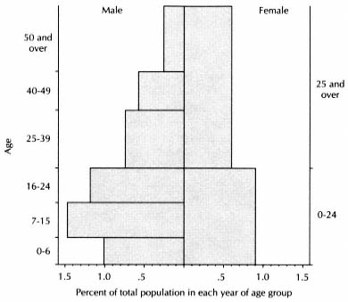
Figure 7.4.
La Mata, Population Structure, 1753
Note: Since there is no limit to the top age groups, a span
of seventeen years for males is used for convenience only.
| |||||||||||||||||||||||||||||||||||||||||||||||||||||||||||||||||||||||||||||||||||||||||||||||||||||||||
these omissions, I shall consider the catastro complete for males over sixteen and females over twenty-five. In the table for Armuña in 1786, these groups represent 53.1 percent of the population. In the catastro of La Mata, these groups total 129 persons; and if these are 53.1 percent of the total, the total is 243, or 18 more than the catastro recorded. The same operation using the 1786 structure of La Mata yields a figure of 260 for the 1753 population. It appears probable that the catastro did underenumerate young people, and we can use 243 as a minimum population in 1753 and 260 as a maximum.
Dividing the net town income from Table 7.14 (4,683 EFW) by these estimates, one obtains a per capita income of between 18.0 and 19.3 EFW per year. This was half again more than the 12 EFW per capita that I have estimated provided an adequate subsistence for the rural Spanish population.
In addition, the censuses reveal an indirect source of income that the catastro could not record. A population beehive of the town in 1786 shows a remarkable shortage of females between seven and fifteen (Fig-
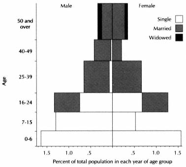
Figure 7.5.
La Mata, Population Structure, 1786
NOTE : Since there is no limit to the top age group, a
span of seventeen years is used for convenience only.
ure 7.5).[73] There were forty boys and only sixteen girls in this age group. Even allowing for underenumeration, one can be reasonably sure that there was a shortage of unmarried girls in 1786, and this phenomenon was probably already present in 1753. In all likelihood their absence is evidence of a practice of sending girls to serve in the city, with the intention of returning to marry when they reached the proper age.[74] Meanwhile they represented fewer mouths to feed, and their labor, unlike that of their brothers, was not needed in the fields or on the road.
In the middle of the eighteenth century, La Mata was a prosperous town of some sixty families. All thirteen labradores, all but one of the twenty-four arrieros, and the priest, altogether two-thirds of the households, had incomes that allowed them to live with ease. Of these at least
[73] For the data of the 1786 census of La Mata, see Appendix N, Table N.6.
[74] See Scott and Tilly, "Women's Work," for an analysis of this widespread practice in the nineteenth century.
nine labradores, eight arrieros, and the priest earned twice or more what their families needed for an adequate standard of living. The tavernkeeper and surgeon-bloodletter turned a fair penny, and only the large size of their households kept their per capita income from being among the higher levels. Most of the other families, headed by artisans, jornaleros, herders, and widows, no doubt supplemented their direct income by tilling a small plot as a senarero or doing odd jobs for others or for the church or the town council. The town profited from a dual economy based on agriculture and muleteering. The income of the arrieros represented about 6.5 EFW per capita. Had these men been engaged in agriculture, even if in so doing they had increased the harvests through more intensive cultivation, the per capita income would have declined to close to the adequate mean. Their activity made possible the flourishing economy of the town in the face of the small extent of land per vecino.
This little community would have warmed the hearts of the Madrid reformers. It is true that its vecinos did not live on separate, enclosed homesteads or own their own land as the reformers propounded, but they had fairly stable, assured leases, which allowed them to make a comfortable living and produce a healthy excess for the market. They could keep six fanegas of wheat for each person in the community and all the other grains and pulses from the harvest and still leave two thousand fanegas of wheat to export, as rent, as tithes, or for their own account. Fewer than four hundred such communities, one hundred thousand people in all, could supply all the wheat Madrid needed. Campomanes recommended that rural communities introduce domestic manufactures that would use local raw materials and give remunerative occupations to the women and children.[75] Although we do not know what the women and children did in their homes, La Mata had no active artisan sector, but the arrieros did provide a mixed economy and were responsible for the substantial margin of well-being of the community as a whole. If all arid Spain had been like La Mata, agricultural reform would never have become the dominant domestic issue of the last decades of its old regime.
For their well-being, the people of La Mata paid with the timeless labor of rural folk. The labradores, their jornaleros, and their sons hitched their oxen to their plows and worked their tiny scattered plots in the cold winds of the winter and early spring; later they bowed under the parching July sun to harvest the ripe wheat with their sickles and
[75] Rodríguez de Campomanes, Industria popular.
rode their heavy threshing boards behind their oxen round and round the town threshing floor, the eras, to separate the grain from the chaff—a task in which wives and children could join—loaded their carts or animals in August with the wheat they owed their landlords in Salamanca and in the fall cared for their newborn lambs and slaughtered their pigs. The arrieros heaved the bags of grain on their mules and donkeys after the harvest, heading for the main regional markets or setting out on the long journey north to Burgos and Bilbao, walking beside their beasts in all kinds of weather, unloading in the evening and loading again in the morning the goods that provided their livelihood. They returned in time for Christmas but set out again as soon as the roads were passable, getting home once more for the June fairs. Following the local custom, the arrieros of La Mata traveled together for security and company. They helped each other and needed few additional hands, and their sons stayed to work for other vecinos until they were ready to set up in their fathers' trade. Then they would join the group to learn the routes and the best pastures and watering holes.[76] Meanwhile the wives kept the hearths alive, prepared the thick bread soup of breakfast and supper, washed and mended the clothes, and in the fall made the farinato sausages of pork and crumbs.[77] The daughters of the poorer families spent their adolescence serving in the city, and the widowed grandmothers took care of the children too young to work.
Religious holidays solemnized the revolution of the seasons that marked the life of La Mata. The town council's budget provided 110 reales for a preacher in Lent, possibly a friar from Salamanca, and another 60 reales for the parish curate to say extraordinary masses on other occasions.[78] The parish had four confraternities that supported special services out of the income provided by the lands they owned. They were dedicated to Corpus Christi (ten weeks after Easter), Saint Michael (29 September), Our Lady of the Rosary (7 October), and All Souls (2 November).[79] These were all occasions for pageantry, but they could not compare with the town fair of 26 June, the feast of San Pelayo, patron of the parish.[80] Then the grain fields were almost ripe, and
[76] On the lives of the arrieros, Cabo Alonso, "La Armuña," 127–29. The author's source is evidently the community memory, for he is a native of La Mata.
[77] On the soup and farinato sausages, Cabo Alonso, "Antecedentes históricos," 81–82.
[78] La Mata, resp. gen. Q 25.
[79] Cofradías del Santísimo, de San Miguel, de Nuestra Señora del Rosario, and de Animas, La Mata, maest. ecles., ff. 64–77.
[80] The parish was named San Pelayo Magno, according to the census return of 1786.
the farmers knew if the harvest would be plentiful. The muleteers had returned from their spring trip with wares to hawk—iron tools and copper and brass pots and pans from Basque forges, perhaps woolens from northern Europe. Vecinos of nearby towns brought livestock to trade. Solemn mass and the inevitable procession sanctified the occasion, a symbiosis of religion, business, and festivity.[81] Different but equally central to the year's course was the day in August when the vecinos who harvested grain paid their tithes "to God our Lord," as the catastro says, and the earthly vicars who received them for Him provided refreshments for the parishioners.[82] To judge from the tithe rolls of the end of the century, the farmers followed an accepted custom in delivering their holy dues. The larger tithers held back, letting those with smaller harvests settle their accounts with the cillero. As the day advanced one or two labradores would come forward among the senareros. Then as the procedure neared the end, the wealthy farmers produced their large contributions, until all had paid except a few who farmed on the side and now closed the accounts with their pittances. On these occasions Francisco Rodríguez, the tavernkeeper, must have dispersed a good share of the 800 reales' worth of wine he imported each year.[83] Religion dominated the public life of the community, and the figure who embodied religion for the people was don Juan Matute, the priest. More than anyone else, he was the hinge figure of the community, their procurator before the outside world, earthly as well as heavenly. The vecinos were conscious of course of the economic differences arising from their varied occupations and incomes—the labradores and arrieros must have had their little rivalries, and they preferred to marry their children to children of their fellows—but except for don Juan, they were socially homogeneous, a close community ruled by tradition and the demands of the seasons.
7
Perhaps the condition of La Mata was too favorable to endure. Within a generation its well-being was shaken, victim of the fecundity of its vecinos and its attraction for outsiders. The evidence for its demographic development comes from the five known censuses of La Mata made be-
[81] Cabo Alonso, "La Armuña," 127.
[82] La Mata, resp. gen. Q 15. This expense is listed in the tithe records (1800) and passim.
[83] La Mata, resp. gen. Q 29.
fore the nineteenth century. All but the last one, of 1786, count only the vecinos, but we can also use our estimate of the total population in 1753. Since the census of 1786 includes the population of the neighboring despoblado of Narros de Valdunciel with that of La Mata, one does well to look at the two places together.
The censuses tell a tale of demographic decline and recovery (Table 7.17). In the sixteenth century Narros was a going village of perhaps fifty people. It virtually disappeared in the next century. The vecindario of 1712 records only one vecino, and there was still only one at the time of the catastro, the warden of the fields (guarda de panes ), who lived with his wife and one son.[84] La Mata was a bigger community and declined as well in size, although the figure of fifteen vecinos in 1712 is assuredly too low. An analysis of that vecindario indicates that it underenumerated the population throughout the province. In 1729 twenty-two farmers paid tithes, and the number of vecinos would have been greater.[85] The catastro count of vecinòs in 1753 and the census of total population in 1786 are reasonably trustworthy. The town grew throughout the century. In the thirty-three years between 1753 and 1786, the total population and the number of vecinos of the two towns grew about 39 percent.
The marriage pattern reveals the main cause for this growth. In 1753 only one man over twenty-four besides the priest was single, a criado (servant) aged thirty. Yet only one of the twenty males between sixteen and twenty-four was married, an arriero aged twenty. In 1786 two men over twenty-four besides the priest were single, but twenty-one of the forty-four males between sixteen and twenty-four were married.[86] The average age at marriage for men had declined from about twenty-five to between twenty and twenty-one. One suspects that the decision to marry younger was an effect of the favorable economic situation at midcentury, and it meant that the town in 1786 could be expected to have a higher birthrate than a generation earlier. Because no one owned all the plots he tilled and the calling of muleteer was not closed, there were no economic "niches" that had to become empty before one could marry.
But the prosperity of the town did more than encourage early marriage; it drew outsiders to the town like a magnet. Migration is hard to document historically, but here we are helped by the various listings of the inhabitants. The tithe rolls of the end of the century record the
[84] AHPS, Catastro, Narros de Valdunciel.
[85] Cabo Alonso, "La Armuña," 114.
[86] See Appendix N, Table N. 6, for the census returns of 1786.
| ||||||||||||||||||||||||||||||||||||||||||||||||||||||||||||||||||||||||||||||||||||||||||||||||||||||||||||||||||||||||||||||||||||||||||||||||||||||||||||||||||||||||||||||||||||||||||||||||||||||
names of all vecinos who raised crops. Of fifty-two tithers in 1799, seventeen (one-third) had surnames (apellidos ) that did not figure among those of the vecinos of 1753. Nine of them paid small amounts and were senareros, perhaps farm laborers recently come in search of work and settled in the community. But six were substantial labradores, in the top quarter of the tithe roll. These figures do not mean that a third of the population had come in from elsewhere. Antonio, Bernardo, and Joseph Prior, respectively the sixth, tenth, and eleventh labradores, could all be sons of a worker who arrived in the 1760s and married well. Yet the appearance of eleven different surnames in a couple of generations is clear evidence of a generous infusion of new blood into the community.
The number of men engaged in the major economic sectors, agriculture and transportation, rose faster than the population as a whole, by 120 and 70 percent respectively (Table 7.18). On the other hand, the census of 1786 lists no artisans, where there had been two in 1753. Both of them, as we saw, had miserable incomes and had to farm part-time. Was someone keeping the crafts alive in 1786, but listed as a jornalero because he worked in the fields too? Or were the crafts abandoned as unproductive? The answer is probably yes to both questions. The scene
| ||||||||||||||||||||||||||||||||||||||||||||||||||||
with which this book begins shows a linen weaver present in 1800. On the other hand, when we study the next town, Villaverde, we shall see that there, too, the number of artisans was declining. At the end of the century La Mata was becoming divided more than ever into two distinct economies.
With so many more people farming, one would expect their more labor-intensive economy to result in greater income from the land, even if the marginal product of labor declined. Yet they do not appear to have achieved this growth. One can follow the evolution of the harvests in the tithe records. Table 7.19 compares the tithes collected over three periods centering on 1750, 1772, and 1798. It reveals a clear trend toward a smaller proportion of the harvest in grains and a greater one in pulses. Rye, barley, and oats, never very important, virtually disappeared, and wheat, the crop for which La Armuña is famous, declined from 81 to 72 percent of the value of the harvest. Garbanzos rose from 4 to 21 percent of the harvest, and the farmers experimented with vetch (arvejas; the vecinos called them both hervejas and alberjas ), a fodder crop, and peas. They were evidently trying to rotate their crops, using fast-growing pulses like garbanzos, peas, and vetch, which could be planted in January, permitting a half year of fallow after the previous wheat harvest.[87] The makers of the catastro complained bitterly over the practice of planting garbanzos, algarrobas, and barley in what should have been the year of rest, accusing the practice of reducing the wheat harvest.[88] The farmers, on the other hand, with increasing labor available, may have been responding rationally to the market. If one evaluates the harvest at the end of the century in EFW using the prices of midcentury, the total value of the yield did not rise. On the other hand, if garbanzos were a superior good and rising faster in price than wheat, as some evidence suggests, then the switch to them brought a net gain (Appendix H). Also, with agricultural prices rising somewhat more than nonagricultural prices after 1760 (Table 7.20), the terms of trade were moving in favor of the rural sector, making the harvest more valuable against outside purchases. The gain would not have been great, however, and it will not vitiate my analysis to assume a harvest of constant value.
The peasants did not try a rotation different from the año y vez, although it has been argued that a triennial rotation was possible in this region, with a year of spring grains or legumes, part of which would
[87] See Cabo Alonso, "La Armuña," 368–69.
[88] La Mata, resp. gen. QQ 4, 11.
| ||||||||||||||||||||||||||||||||||||||||||||||||||||||||||||||||||||||||||||||||||||||||||||||||||||||||||||||||||||||||||||||
| ||||||||||||||||||||||||
serve as fodder, inserted between the winter wheat and the fallow year. The rotation was not unknown, but the peasants were under pressure to produce wheat, both to meet the terms of their leases and because it was more marketable than barley or rye. Although a three-year rotation was more productive, it would reduce wheat production by 33 percent, a choice they could not afford.[89]
By 1800 the number of farmers had doubled since midcentury. They had to compete for leases, and the effect was that the number of plots per farmer was halved, with a corresponding decline of income per head. Moreover, the farmers had to struggle to keep the rents down. The 1770s saw a series of good harvests (see Table 7.19), and landlords used the occasion to increase the rents, which remained at the new level until the end of the century.[90]
The proceeds from farming could not keep abreast of the growth in population. Other solutions had to be found, and they involved a search for income from outside the town. In the 1780s opportunity came from the despoblado of Narros de Valdunciel, bordering on La Mata to the northwest. Eighty-five percent of its area belonged to the monastery Nuestra Señora del Jesús of the Sisters of Saint Bernard, whom we have already met as one of the owners of land in La Mata.[91] The rest belonged in small lots to other institutions in Salamanca and to vecinos and churches of nearby towns. Although its area was one and a half times that of La Mata, we have seen that in 1753 its sole permanent inhabitants were the warden of the fields and his small family. The monastery rented its entire share of Narros to eight vecinos of Carbajosa de Armuña, which bordered it on the opposite side from La Mata. The lease called for 300 fanegas of wheat, 75 of barley, 2 7/12 of garbanzos, and a cart of straw annually for the arable, and 825 reales for the grazing rights.[92] By 1769 the town council of La Mata was subleasing onequarter of Narros from its tenants, paying 100 fanegas of wheat.[93] In 1777 the town council of Carbajosa took over the lease, but in 1780 La Mata joined it in the contract. By now the rent had risen to 450 fanegas of wheat, 100 of barley, 3 of garbanzos, eleven chickens, a cart of straw, and 2,000 reales, an increase of about 50 percent since the catastro, no doubt
[89] García Fernández, "Champs ouverts," 699–701.
[90] See above, Chapter 7, section 2.
[91] AHPS, Catastro, Narros de Valdunciel. The monastery owned 1,344 fanegas out of a total of 1,584. Technically Narros was an alquería, or grange, but the difference from a despoblado was not very clear.
[92] AHN, Clero, libro 10668, f. 113.
[93] Archivo Parroquial, La Mata, tazmía, f. 1.
reflecting an increase in harvests and herds. Two keepers and their families now lived on the estate. How the town councils exploited their lease is not known; they probably sublet the contract to several of their labradores. Here was one way for La Mata's farmers to fight their declining income: by breaking new ground in the despoblados around them.
The joint lease lasted nine years. In the 1780s the royal government pushed the colonization of the despoblados of Salamanca province, following its settlement policy in Andalusia and Extremadura.[94] With royal urging, the nuns agreed to repopulate Narros, and they turned to La Mata and Carbajosa for colonists. In 1789 twelve vecinos of La Mata and three of Carbajosa moved with their families, animals, and tools to the depopulated village. In a low hollow, hardly more than a kilometer from La Mata but hidden by a slight knoll, where only the houses of the wardens had stood, nineteen more were being built for the "new settlers of Narros." An agreement had been reached the previous fall in time for the settlers to benefit from the winter pasture, and a notarized contract confirmed it in April 1789. The fifteen farmers leased the lugar of Narros on the same terms as the contract of 1780, with the substitution of a 90-to-100-pound heifer for the eleven chickens, and two reales for each house as a permanent quitrent (foro perpetuo).[95]
To undertake such a venture, the settlers had to be enterprising, respectable men. Among them was Antonio González, alcalde of La Mata in 1786.[96] Most of them were heads of families in the prime of life: in 1798 nine of the twelve emigrants from La Mata still appeared on the tithe rolls, but by 1808 only four were alive.[97] Under their care, the community took root and prospered. They raised sheep as well as grain and cattle; in 1802 they paid the nuns forty sheep in lieu of the two thousand reales for the pastures. By 1826 Narros had sixteen vecinos and a population of sixty,[98] and it is still there today.
In this way La Mata disposed of one-seventh of its vecinos and over a quarter of the men engaged in agriculture, easing the economic threat to its farming population. Muleteering offered another source of additional outside income. The number of arrieros rose 70 percent between 1753 and 1786 (Table 7.18). Available evidence indicates that in the second half of the century the price of muleteers' haulage rose at about the
[94] See Chapter 18, section 4.
[95] AHN, Clero, libro 10668, f. 121v.
[96] He is identified in the census return.
[97] The tazmía of La Mata includes the tithe returns of Narros, its anexo.
[98] Table 7.17.
same rate as the general price level.[99] If each of the arrieros of La Mata continued to operate with as many animals as before—animals, unlike fields, could be multiplied—their average real per capita income remained the same, with a resulting gain for the community as a whole. I assumed that 75 percent of their gross income in 1753 came from outside the town. Since local harvests had not increased, almost all their new business would have been external. In 1753 their net income from haulage was 2,070 EFW. Now, the additional arrieros would have increased this amount about 70 percent, or 1,450 EFW, of which perhaps 1,300 EFW (90 percent) was additional income for the town from outside. This amount was 28 percent of the net town income of midcentury (Table 7.14), and it went far toward balancing the population growth of 39 percent over this period. The per capita income was still 17.5 EFW in 1786, and the emigration of twelve vecinos or about forty-five people three years later meant that it rose to almost 20 EFW.
Thus La Mata solved the demographic threat to its economic standing. In 1790 the vecinos felt wealthy enough to construct the handsome espadaña that decorates the parish church, a sculptured prolongation upward of the facade that serves as a belfry, rivaling in elegance the square church towers of their neighbors. But a change had taken place in the social structure. Whereas before the labradores had been the dominant class in the town economically, now the arrieros were their match, if not their superiors.
8
Such was the situation in La Mata when the king decreed the disentail of the properties of charitable and other religious endowments in September 1798. Since religious institutions owned 78 percent of the land in the town, a good half of this subject to sale, his decree opened the possibility for a radical change in the structure of local property and indirectly of the society.
Sales began in La Mata at the end of 1799. The first consisted of seven arable plots in the town and three in neighboring San Cristobal de la Cuesta that belonged to a memoria in a parish church of Salamanca.[100] The second was of six plots in La Mata and two in Narros, property of a memoria in the cathedral of Salamanca.[101] Both lots were bought by don
[99] Ringrose, Transportation, 81–86, esp. 84.
[100] AHPS, Contaduría, libro 850, ff. 455r, 477r–478r.
[101] Ibid., ff. 478r–479r.
Joseph María Cano Mucientes, military commander of the province of Burgos[102] and a knight (caballero ) of the Order of Carlos III, a resident of Madrid. He also made the third purchase, first of 1800, larger than the others, seventeen arable plots and three meadows in La Mata plus assorted lands in Valdunciel and Narros, property of another memoria in the cathedral.[103] The fourth sale went to a member of the faculty of the University of Salamanca, don Antonio Reyrruard, four plots in La Mata and two in Narros that belonged to a third memoria of the cathedral;[104] and the fifth, a plot in La Mata sold along with others in Narros and other nearby towns that belonged to a capellanía in the town of Negrilla, went to a priest whose parish was in Aldeadávila de la Rivera, on the Portuguese frontier.[105] After the first six months of disentail, La Mata faced the prospect of exchanging one set of outside landlords for another.
By the summer of 1800, the vecinos became aware that they must compete with the wealthy men of the cities if they were not to lose the opportunity the king had given them. Several took up the challenge. In July Pedro González of La Mata obtained a large arable field belonging to a capellania of Salamanca, paying 2,330 reales.[106] A month later Antonio Alonso López, one of the wealthier labradores, bought a block of lands in La Mata, Narros, Valdunciel, and Carbajosa de Armuña for 12,200 reales.[107] Thereafter other vecinos entered the bidding and frequently won the auction. Of thirteen sales of land in La Mata in 1800, five went to its vecinos and two to those of nearby towns.[108]
To see how the vecinos defended themselves we can follow one of their purchases in the notarial records.[109] In October 1800 the commissioner of the Amortization Fund selected for sale the properties located in the towns of La Mata, Narros, and Negrilla de Palencia belonging to the Cofraía de Animas of the parish church of San Juan de Jerusalén of Salamanca. Two assessors were chosen, a labrador of Monterrubio and another of the Puerta de Zamora, a suburb of Salamanca, who spent three days evaluating the lands. Three plots totaling 4.25 fanegas in
[102] Sargento mayor del Regimiento Provincial de Burgos.
[103] Ibid., libro 851, ff. 145r–146r.
[104] Ibid., f. 146r–v.
[105] Ibid., ff. 146v–147r.
[106] Ibid., f. 148r–v.
[107] Ibid., ff. 149r–v, 114r, 296r.
[108] Ibid., ff. 148v–152r; libro 852, ff. 92r–94v. The last sales were recorded in 1801 but the money was paid in 1800. See AHPM, López Fando, C1346, C2752. Two sales recorded in Madrid but not in the Salamanca contaduría are C1347 and C1348.
[109] AHPS, Sección Notarial, libro 3844, ff. 23r–45v. The sale is in AHPS, Contaduría, libro 852, ff. 92v–93r.
Negrilla they agreed were worth 2,925 reales, and seven plots in La Mata and Narros measuring 9 fanegas, 6,305 reales. Four days after they submitted their report, on 16 October 1800, a notary of Salamanca, don Carlos María Pérez Albarez de Rueda, made a bid on all the lands, offering 9,400 reales payable in vales reales, only a few reales above the total assessment. The alcalde mayor of Salamanca city, the competent royal authority, declared his bid in order and set the date for the auction as 19 November, allowing thirty days for public announcements. Notices were posted in Salamanca, Palencia de Negrilla, and La Mata, the last on the main church door, beneath the espadaña. Every day for thirty days the public crier of Salamanca proclaimed the description of the lands, the amount bid, and the date of the auction. Within ten days, two vecinos of La Mata, Santiago Cabo and Juan Hernández, appeared at the office of the notary in charge of the sale and made a second bid: 9,233 reales in vales reales for the 9 fanegas in La Mata and Narros. In effect they requested that the properties be divided in two lots, and to obtain their request they offered almost as much for those in their vicinity as Pérez Albarez had for all the lands. Cabo signed the document, Hernández merely scribbled some swirls, "since he does not know how to sign," as the notary delicately put it. Their bid was declared satisfactory, and the public crier henceforth proclaimed it in his announcement.
On 19 November the public auction, in the entrance hall of the royal jail of Salamanca, opened at eleven o'clock in the morning. The crier announced the pending bid and invited whoever wished to raise it. Many people attended, including Juan Hernández acting for himself and his partner, but try as he might, the crier could raise no response. When he paused, the alcalde mayor ordered him to keep on, and unexpectedly Hernández, who was illiterate and perhaps confused by the strange event and the imposing setting, broke the silence to raise his own bid by two hundred reales. His was the only voice from the public. Finally the alcalde mayor closed the session and awarded the fields to Hernández and Cabo.
According to practice at public auctions, however, this was not the end. The closing bid was published in Salamanca and La Mata, and prospective buyers were given forty days to raise it by 25 percent (la mejora de la cuarta parte ) and thereby reopen the bidding. Again the announcement on the church door in La Mata had the desired effect, for on 26 November two different vecinos, Francisco and Marcos González, went to the notary's office in Salamanca and offered 11,808 reales for the
9 fanegas, also in vales, barely more than the required raise. A new date for the auction, 7 December (a Sunday), and new announcements. The act took place in the accustomed manner, and again, despite the coaxing of the public crier, no one raised the bid. This time the decision was final, and the two Gonzálezes received the lands. On the next day they paid the money to the commissioner of the royal fund, and the alcalde mayor signed the necessary papers.
On 11 December the notary went in person to La Mata to deliver the lands. The symbolic act of transfer to the new owners before the assembled residents of the village is the opening scene of this book. The final act took place two weeks later. The two Gonzálezes and Juan Hernández, the active partner in the earlier bid, journeyed to the notary's office to have the deed drawn up. The two buyers ceded three of the fields to Hernández and divided the other four between them. Santiago Cabo, the other early bidder from La Mata, had lost out, but the vecinos had defeated the notary of Salamanca who first bid on the land and had raised the price even further in their competition with each other. The confraternity received from the king an obligation for almost double the assessed value of its fields.
After 1800 the amount of land put up to auction declined. In 1801 there were six sales, in 1802 three, in 1803 two, and in 1804 one. Vecinos of La Mata made eight of these twelve purchases and vecinos of neighboring towns two others. Outsiders seemed to lose interest when faced with a serious local challenge. Residents of Salamanca made only two purchases involving five plots.[110]
These sales exhausted the lands specified in the instructions of January 1799, which stated that properties of hospitals, asylums, and similar institutions not be touched until all others had been sold. On 30 September 1805 a circular ordered the disposal of the properties of these institutions.[111] Amorg them was the largest landowner in La Mata, the General Hospital of Salamanca, which held sixty-eight arable plots and one meadow, evaluated by the catastro at 15 percent of all the property in the town. They went on sale early in 1806 in twenty different sets. This time the vecinos were prepared. Sixteen of them, including a man called don Josef de la Iglesia, and his wife, doña María Antonia de Rivas, banded together to bid for the lands. They obtained nineteen of the sets, the twentieth going to a member of the university, don Josef
[110] These twelve sales are in AHPS, Contaduría, libro 852, ff. 94v–98r; libro 853, ff. 37r–40r; libro 854, ff. 65r–66r; libro 855, f. 75r.
[111] Circular, 30 Sept. 1805, AHN, Hac., libro 8057, no. 6716.
Pando.[112] Two other sales, lands of the orphanage of Salamanca, closed out the year and the disentail in La Mata under Carlos IV. They went to a vecino.[113]
Most of the properties that changed hands already belonged to religious endowments in 1753 and can be identified in the catastro: 204 arable plots, eight meadows, and a house. Others not identified in the catastro as religious holdings were presumably acquired by the church between 1753 and 1798. Altogether 222 plots were sold, 40 percent of the 551 plots listed in the catastro; of the total property value, 42 percent was sold. Taking place in eight years in a town where virtually no land had been put on the market in centuries, the disentail constituted a massive revolution in the ownership of property.
After a bad start, the people of La Mata had rallied to exploit the opportunity. They obtained 116 of the 222 grain plots, and in addition vecinos of nearby towns obtained 24 plots. Most of the rest went to residents of Salamanca. Table 7.21 and Figure 7.6 reveal what these exchanges did to the property structure of the town. There are two major features to the changes. On the one hand, local ownership rose sharply, from about 10 percent to 35 percent, mostly in gains by the vecinos, who had eight times as much property as at midcentury; ownership located in Salamanca declined from 63 to 41 percent. On the other hand, ecclesiastical institutions lost half their holdings; their share fell from 78 to 39 percent. Where previously ecclesiastical landlords dominated the town, there were now three fairly equal forces present, religious institutions, nonresident individuals (some of them clergymen), and the vecinos of La Mata and neighboring towns. La Mata ceased to be in the absolute grip of the nearby city.
If La Mata was a typical example of the effects of the disentail of Carlos IV, the royal ministers had every reason to congratulate themselves on their achievement. They had provided property to industrious farmers while raising money for the urgencies of the crown. Their success depended, however, on local conditions. Although in recent decades the economic status of La Mata's farmers had been under threat, they had maintained a level of income that permitted them to live adequately and save. Some muleteers also had earnings beyond their needs. Until 1798 the vecinos had little opportunity to invest their savings in ways that would increase their income. The purchase of land had been virtually
[112] AHPS, Contaduría, libro 856, ff. 117r–124r.
[113] Ibid., ff. 124r–125r.
| ||||||||||||||||||||||||||||||||||||||||||||||||||||||||||||||||||||||||||||||||||||||||||||||||||||||||||||||||||||||||||||||||||||||||||||||||||||||||||||||||||||||||||||||||||||||
out of the question, since four-fifths of the land in La Mata was in religious entail. Not entirely fortuitously, the royal decree came when farmers were able to take advantage of it.
For the town as a whole, the greatest benefit was to be freed from part of the rent it paid to outside owners. Vecinos bought 220 fanegas of arable land; 196 of this had belonged to outside religious institutions.
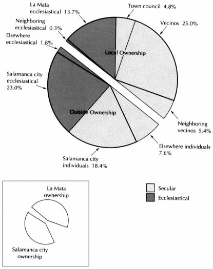
They also bought at least thirteen plots measuring 26 fanegas in Narros and other nearby villages, all of which had belonged to institutions in Salamanca.[114] Meanwhile residents of Salamanca had bought 14 fanegas of land in La Mata belonging to churches of La Mata and nearby towns. The net gain for the town economy was rent from 208 fanegas of land.
[114] Ibid., libro 851, ff. 114, 296r; libro 852, ff. 92v–93r; libro 853, f. 48r–v; libro 856, f. 131v.
Under the decree of 15 September 1803, the new outside owners were free to raise the rent, but we have seen that the monasteries were unable to do so without the tenants falling behind, so that it is doubtful that the new owners could squeeze much more out of the tenants. At the rate of 0.8 fanega of wheat per fanega of land that was the usual rent, the land transfers netted the town economy about 167 EFW more per year. In 1753 vecinos paid outside owners 575 EFW; this would now be about 410 EFW, and the net income from agriculture would rise from 3,132 to 3,299 EFW (Table 7.14). The overall benefit was to raise the town income from agriculture about 5 percent. The farmers as a group benefited more because they were also freed from the rent paid to local churches on 25 fanegas of land, about 22 fanegas of wheat. Their net income rose from about 2,682 (Table 7.8) to about 2,871 EFW, an increase of 7 percent.
9
Had other conditions remained stable, this increase would have meant a distinct improvement in the position of the farmers. But their number did not stop growing. From Table 7.17 we know that the population of La Mata was about 333 in 1786, with about 80 vecinos (allowing for 2 vecinos and 8 people in Narros). The next date for which we have population figures is 1826. La Mata then reported 107 vecinos and 482 people. The growth between these dates was not consistent, however. The 12 families that emigrated to Narros in 1789 took perhaps 48 people. In 1803 and 1804 the harvests were very poor in Salamanca province, as in most of Spain, and the ensuing famine brought on an epidemic that carried away a large number of people.[115] One would have to study the parish registers of baptisms and burials to get a full sense of the demographic impact on La Mata, but the tithe records provide convincing evidence (Table 7.22). The number of people on the rolls fell about 20 percent from 1802 to 1805. This loss did not represent an elimination of marginal farmers, for the number who paid first fruits declined more, about 23 percent. La Mata must have lost a fifth of its adults in the epidemic and at least as many children.
[115] In La Mata the wheat tithes in these years were 158 and 160 fanegas. In the previous three years they averaged 317, in the following three, 270. The records of the convent of La Concepción of Salamanca, speaking in 1804 of the death of two tenants in Tardáquila, just north of La Mata, mention "la epidemia que hubo en los lugares" (AHN, Clero, libro 10854, ff. 41r–44v). See Peset and Carvalho, "Hambre y enfermedad," esp. Appendix E. The authors do not believe there was a major increase in mortality, but the evidence here is different.
| |||||||||||||||||||||||||||||||||||||||||||||||||||||||||||||||||||||||||||||||||||||||||||||||||||||||||||||||||||||||||||||||||||||||
| ||||||||||||||||||||||||||||||||||||||||||||||||||||||||||||||||||||||||||||||||||||||||||
If one assumes that the growth rate was constant for the rest of the period (there was another famine during the Napoleonic war, but its effect can be discounted here), then we can approximate the population and the number of men in agriculture at different dates as in Table 7.23.
We have seen that the total net income from agriculture did not rise much, if at all, after the middle of the eighteenth century, and that the income of the farmers increased about 7 percent as a result of the disen-
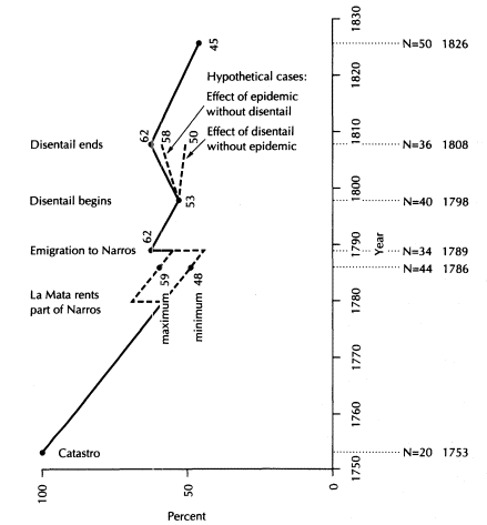
Figure 7.7.
La Mata, Index of Per Capita Income of Men in Agriculture ( base = 1753 )
Note: N = number of men engaged in agriculture (from Tables 7.1 and 7.23).
tail. This information makes it possible to plot the evolution of the average per capita income in EFW of the men in agriculture (not to be confused with the per capita income of the town as a whole). Figure 7.7 shows that the major factor affecting the income of the farmers was their number. The rush into agriculture after 1753 rapidly brought down the individual income until the vecinos turned to farming land outside the town, first by renting part of Narros in 1780 and then by sending emigrants to it in 1789. Even so, the index of per capita income
of men in agriculture, with the base 100 in 1753, stood at only 62 by 1789. The decline continued until two factors combined between 1798 and 1808 to bring the level of income back to that of 1789: the disentail and the epidemic. Of the two, the epidemic had the greater effect. Without disentail, it would have raised the index from 53 in 1798 to 58 in 1808. Without the epidemic, disentail would not have prevented the income of farmers from continuing to decline. The income of the town as a unit held up much better, because the large sector engaged in haulage would continue to increase its contribution. One can suppose that some of this income filtered over to the families of farmers through services rendered, so that they were not so badly off as the graph suggests.
What the graph does reveal, however, is the weakness of property redistribution as a means of social reform in a period of demographic expansion. One could hardly find a place where the effects could have been more favorable to local residents, both because of the large amount of property sold and because they managed to acquire over half of it. Even if all the land disentailed had gone to the vecinos, 366 fanegas, their rent would have been reduced 293 fanegas of wheat, and their income would have risen 11 percent. Indeed, if all the land and pastures except the land of the town council had been turned over to the vecinos, representing rent of 733 EFW (Table 7.8), their total net income would have risen about 27 percent, bringing the index for 1808 up to 74, still well below the level of 1753.
Ending rent payments was not, however, the only benefit conceived by the planners in Madrid. They counted on private ownership to increase the harvests, but given contemporary technology this was unlikely. The labradores continued to experiment modestly with crop variations. Garbanzos, which had risen to 21 percent of the value of the harvest in 1797–99, fell back to 7 percent in 1805–9, only to rise again to 17 percent in 1815–19. At the latter date peas had appeared, after being sown in small amounts at the turn of the century, and were now 6 percent of the crop. But the value of the harvests in EFW changed little. In 1807–8, both good years, the average of the tithes recorded by the cillero was almost exactly the same as in 1801–2, also good years. In 1815–19 tithes averaged 91 percent of this amount, and all of these figures indicate harvests below the record years of 1770–74. Until farming technology changed, which hardly occurred before the twentieth century, only extensive breaking of new ground in nearby despoblados (so long as they were available), massive emigration, or turning to other oc-
cupations like muleteering could maintain the standard of living of the farming sector.[116]
10
If disentail brought only marginal benefit to those in agriculture as a group, perhaps it changed more radically the condition of the persons who actually acquired land. Thirty-five people bought property in La Mata, twenty-two of them vecinos. Table 7.24 shows the residence of each buyer and what percentage of the total value of the town's land (as assessed at the time of the catastro) each bought. They are listed in descending order of the value of their purchases.
The table reveals a fairly clear pattern. Of the top four, each of whom bought considerably more than the others in the list, only one was a vecino, the others being urban residents, from Salamanca and Madrid. The middle ranks, from fifth through twenty-sixth, were made up almost entirely of vecinos of La Mata, with a scattering from bordering towns. The first of the latter, Blas Rodríguez, was one of the original emigrants to Narros in 1789. Of the remaining nine buyers, seven lived outside La Mata (although three in neighboring towns). The very narrow range of the purchases made by vecinos is striking; nineteen of the twenty-three each bought between two and seven plots, the largest purchaser of these acquiring less than double the land value of the smallest. It is true that this similarity is exaggerated by assigning equal shares to the sixteen who banded together in 1806 to get the lands of the General Hospital, but I do not know how they divided these lands among themselves. Outside this range are only Francisco González, who bought twenty-three plots, valued at more than twice the amount of any other vecino's purchases; two men, who bought very little; and Joseph Prior, who bought no lands in the término but together with Ignacio Alonso bought two plots in Castellanos de Villiguera to the west. Who were these vecinos?
The records of the sales do not tell their occupations. We can, however, learn much from the tithe register. It reveals how large their harvests were and how these compared to those of other vecinos, both before and after their purchases. Table 7.25 shows the average harvest of each individual who bought land and the rank of his harvest among the
[116] See Cabo Alonso, "La Armuña," 373 and 382, on the limited possibilities for increased agricultural output in the nineteenth century.
| |||||||||||||||||||||||||||||||||||||||||||||||||||||||||||||||
| |||||||||||||||||||||||||||||||||||||||||||||||||||||||||||||||||||||||||||||||
| ||||||||||||||||||||||||||||||||||||||||||||||||||||||||||||||||||||||||||||||||||||||||||||||||||||||||||||||||||||||||||||||||||||||||||||||||||||||||||||||||||||||||||
| ||||||||||||||||||||||||||||||||||||||||||||||||||||||||||||||||||||||||||||||||||||||||||||||||||||||||||||||||||||||||||||||||||||||||||||||||||||||||||||||||||||||||||||||||||||||||||||||||||||||||||||||||||||||||||||
tithers, for four separate two-year periods (since a two-year cycle was needed to till all the fields of each individual) from 1799 to 1808, omitting 1803–4, the years of famine. Not all buyers paid tithes, and others paid only in some years. Those who disappeared from the rolls probably died, and those who were added probably appeared when they set up separate households or began farming. Finally, the table indicates the years in which the buyer made his purchases, in order that one may observe any immediate effect of his purchases on his harvests or rank among tithers.
The census of 1786 reported twenty-seven labradores. Considering the emigration to Narros in 1789 and the intervening growth, there must have been between twenty-five and thirty labradores in 1799. If this is the case, then all but two of the nine top vecino buyers, those ranked third through fifteenth, were labradores, for they were among the top twenty-six tithers in 1799–1800. All of these men made purchases in the first years of the disentail, and five of them also participated in the joint purchase of the properties of the General Hospital in 1806. The economic potential of the seven who were labradores can be judged from their harvests. Net income from harvests after deduction of seed, tithes, and rent was about 58 percent of gross harvests (see Table 7.8). Four of these men had gross annual harvests in 1799–1800 of between 129 and 180 EFW, net between 75 and 105 (Table 7.25). In the two excellent years following, their net harvests were about two-thirds greater. Their position in the socioeconomic pyramid would correspond to the top levels (4 and 5) (compare Tables 7.10 and 7.13). If they had families of five and their needs were covered by 60 EFW, as I have proposed, they had available to save the equivalent of between 40 to 90 EFW per year. If they saved half this amount, one can calculate how many years it would have taken them to accumulate the amount of their purchases,[117] and in most cases the calculation shows that a few years would suffice. Pedro González, who spent 2,330 reales in 1800 and 11,410 reales in 1806, could save about 1,700 reales per year and needed only two years' savings on hand before the sales started. Ignacio Alonso, who spent 10,030 reales in 1802, could have covered this amount with ten years' savings; but in fact if he had put all his surplus of 1801 and 1802 aside in the hope of buying land, this would have covered his purchase. Of the four, only Antonio Alonso López would have had difficulty in financing his successful bids out of savings. It would have taken
[117] Using 40 reales as the price of a fanega of wheat (see above, n. 63).
him twenty years to accumulate the 15,450 reales he spent inside and outside La Mata. But if, as was likely, he paid in vales reales (the record does not say), which were being discounted over 50 percent, he could have saved the necessary money much faster. It is less easy to understand how the other three labradores in this top group made their purchases, since all sales were paid for on the spot and there is no record of any loan or mortgage taken out by the buyers. Nevertheless, it is clear that agriculture was the main source of livelihood of the larger local buyers and very likely also the main source of their capital.
Below these nine local buyers are eleven people who had shares in the properties of the General Hospital but otherwise bought nothing. Six of these eleven also drew their income from agriculture. The next three were marginal farmers, who did not farm every year or harvested only small amounts. Their main occupation lay elsewhere, most likely in haulage. Finally, there are two people in this group who never appeared on the tithe rolls, don Josef de la Iglesia and doña María Antonia de Arrivas, "his wife." The records of the sales of the properties of the General Hospital always name them first among the sixteen buyers. Who were they? The title don indicates an hidalgo, or at least a recognized notable.[118] The catastro and the census of 1786 show no hidalgo in the town. The priest of La Mata, who signed the tithe rolls during the decade of the sales, was don Francisco Ignacio Arribas. Were doña María Antonio and don Josef his sister and brother-in-law, who decided to move to the town, buy land, and live off their income? This seems a likely explanation, and it suggests that their shares of the General Hospital's lands were larger than the others. Their case and those of the other nonfarmers among the buyers indicates that even if the economic position of labradores had declined, land was an attractive investment for people who did not regularly farm. Husbandry still had more prestige in La Mata than muleteering.
The cases of Francisco González and Francisco de la Cruz, first and fourth among La Mata buyers, support this conclusion. De la Cruz was not a farmer in 1799–1800 and only a marginal one thereafter, despite buying three plots in 1802 and sharing in the properties of the General Hospital. Very likely he was an arriero who invested in land but did not make agriculture his main occupation. The case of Francisco González sets him apart from the other vecinos, for he was the only one to rank among the top buyers. He bought nine plots in 1800, eleven plots and a
[118] For the meaning of the appellation "don," see below, Chapter 15, section 4.
meadow in 1801, and three plots in 1802, yet he was not farming in 1799–1800. We saw him take possession of his first fields, which he obtained by outbidding local and Salamanca residents. In 1801 he was twentieth on the tithe roll; in 1802, after three years of buying land, he was fifth.[119] He disappeared from the tithe list after 1803. Did he replace the former first tither (casa excusada) or fourth tither (cuarto dezmero), neither of whose tithes are recorded in the rolls, or did he die? I believe the latter. The name Ana Hernández appeared for the first time in 1804 near the top of the list. She may have been the former first or fourth tither, but more likely she was González's widow. In 1805–6 she was sixth, in 1807–8 third. This appears to have been a household that rose from nothing to obtain the third largest harvest in town. One can guess that González was a wealthy arriero who was inspired by the sales to engage in agriculture.
His case illustrates the importance of the arrieros to the well-being of La Mata. The town defended itself successfully against outside buyers because of its dual economy. The leading labradores had the savings that they and their forebears had set aside for half a century or more. But the agricultural sector did not account for all the town's gains. The muleteers also were amassing capital, and some put it into land when they had the opportunity.
Their judgment was sound, for on the whole those who bought land rose economically. We can follow the development in the second part of Table 7.25. Francisco González is only the most obvious case. Vicente Alonso had the sixth largest harvests in 1799–1800; he was just below the first tither in 1807–8. Antonio Alonso López was tenth at the beginning, fifth at the end; Marcos González rose from twenty-fourth to seventh. Not all were so successful; Pedro González fell from second to sixth; Ignacio Alonso from fifth to eighth. But compare the fate of Agustín de Dios, who was number three in 1799–1800. Since 1787 he and Juan López had rented jointly the lands of the Discalced Franciscan Nuns.[120] Agustín did not buy lands; in 1807–8 he had fallen to number eleven. Bernardo Prior, who was number six in 1799–1800, bought no lands and dropped to number 19 in 1807–8.
It would be wrong to conclude that the increase in a buyer's harvests came just from the lands he bought. In most cases the buyers tilled more fields than those they acquired, as one can tell by comparing their har-
[119] The rank 12 assigned him in Table 7.24 for these years is a result of averaging the two years.
[120] AHN, Clero, libro 10854, f. 24.
vests with the areas they purchased. The account book of the monastery Nuestra Señora del Jesús shows that one of them, Pedro González, second among the buyers, and another man rented its fields in La Mata from 1789 to 1808. González's half share of the crop would have been about 60 fanegas of wheat per year.[121] The plots he bought would have produced only about 46. After 1800 his total harvest averaged over 250. Francisco González, who had never farmed before, bought 30 fanegas of land, which would have produced about 105 fanegas of wheat per year.[122] In 1802 he paid tithes on 262 fanegas of wheat, plus other crops. The plots he bought accounted for less than half of his harvest. The next three buyers who were labradores could produce only between one sixth and one-quarter of their harvests on the lands they purchased.
One can conceive of an explanation for the changing relative size of the vecinos' harvests that has little to do with the disentail. A. V. Chayanov, in his classic studies of the economy of rural Russia before the Revolution, described how the peasant exploitation expanded and contracted as the family proceeded through its life cycle. For a newly married couple the farm was limited to what the peasant could till himself, but as his sons reached an age where they could work, he extended his farm by renting new fields. The exploitation would increase in size until all children reached adulthood, then decrease as the sons left to form their own families.[123] One should consider whether the rise and decline in the harvests of the individual vecinos of La Mata responded to some similar life cycle.
Such an explanation has a certain appealing simplicity, but the knowledge we have developed leads one to reject it as the primary cause. First of all, the monastic account books of the eighteenth century cited at the beginning of this chapter[124] show very little change in renters. Leases were inherited by widows and children, and only tenants who fell seriously in arrears appeared in danger of losing their leases. The free market in rented farms that Chayanov observed in Russia was not present in La Mata. Besides, an increase in the harvests of an individual regularly followed his purchase of disentailed land. In other words, purchases of land were being made when the life-cycle model predicts that sons had not yet reached working age. Yet this is precisely when the peasant, a
[121] The weighted average crop of wheat land according to description in the catastro was 3.0 fanegas of wheat per year per fanega of land (Table 7.2). This must be raised 17 percent to 3.5, because harvests were greater than the catastro predicted.
[122] AHN, Clero, libro 10668, f. 100.
[123] Chayanov, "Nature of Peasant Economy."
[124] Above, n. 16.
struggling young father of hungry children, would be least likely to have savings. According to the life-cycle model one would expect purchases to occur when the family work force was largest and the per capita income therefore greatest, or shortly afterwards. Purchases would be followed by a decline in harvests as adult children left. The relationship between purchases and harvests observed in La Mata thus flies in the face of the life-cycle explanation.
By 1808 all the first nine tithers except the casa excusada and the cuarto dezmero were labradores who had bought land, and perhaps one could identify these as buyers too if one had their names. Furthermore, the share of those at the top was greater than before the disentail. In 1799–1800 the largest tither on the rolls (number two after the casa excusada) paid 7.0 percent of the tithes collected; in 1807–8 the person in this position paid 9.2 percent. The top seven tithers listed in 1799–1800 had 42 percent of the total; in 1807–8, when all of them were people who had bought land, their share was 48 percent. This fact adds further support to the belief that the purchase of properties was a direct cause for an increase in harvests, even one that was greater than the additional return provided by the lands bought.
Disentail benefited ambitious men in more ways than offering land to buy. Every time a vecino purchased a plot to farm himself, he took it out of the supply available to rent and forcibly depressed the remainder of the local farmers. Furthermore, the royal legislation permitted outside buyers to change the conditions of tenure or to rent to new tenants. Although leases had been traditionally renewed rather automatically, new absentee owners would be looking for the best lessee, and a successful farmer would be their first choice. Buying land gave a farmer a reputation that helped him acquire leases held by other vecinos. One cannot explain the meteoric rise of Francisco González in any other way, or the more modest gains of others who also rose in rank. Whereas disentail could only mitigate the decline in per capita income of the farming sector caused by demographic growth, it permitted the more enterprising men to rise within the economic hierarchy of the town. Population growth in the second half of the eighteenth century had reduced the disparities in farmers' income. Disentail reversed this trend and produced a somewhat more stratified society.
11
The war against Napoleon put an end to this period of disentail and struck the town harshly. French armies engaged in Portugal passed
through the province of Salamanca and lived off it, and the campaign of 1812 brought heavy fighting to the region. In November 1812 French troops sacked La Mata.[125] Between 1810 and 1813, the tithe records show harvests scarcely half the size of ordinary years, and monasteries settled for much less rent than their leases called for.
Peace brought back normal conditions and harvests recovered. For the rest of the century the history of La Mata revolved around the forces we have observed. The number of men engaged in transportation increased until midcentury. In 1850 there were fifty-one muleteers and five carters (carromateros ), and ten years later sixty-two muleteers and thirty-eight carters. Thereafter, the appearance of the railroad led to a steady decline of haulage as an economic resource; in 1900 only two arrieros were left in La Mata. Meanwhile the vecinos benefited from the successive waves of disentail. By the turn of the twentieth century, they owned 71 percent of the land in the town, and the renting of fields from nonresidents had almost disappeared as a practice, as outside owners sold off their plots in search of investments with more growth potential. Harvests per hectare rose slowly, but not enough to offset the disappearance of transportation as a source of income. In 1863 the number of vecinos reached 165, its highest point ever.
After 1900 the discovery of a simple chemical process to keep lentils from spoiling before reaching market brought a revolution in crops, and the introduction of artificial fertilizers reduced the need for fallow.[126] Thereafter, the end of haulage and the new farming technology gave the town a very different economy from the one studied here. The half century between the catastro of la Ensenada and the end of desamortización of Carlos IV thus appears as the early stage of a cycle that lasted through the nineteenth century, during which this rural community remained dependent on early modern technology in both agriculture and transportation. Disentail operated as one factor in economic change, along with population pressure and evolution in the means of transportation.
[125] Cabo Alonso, "La Armuña," 387 n. 122.
[126] Ibid., 374–411.
Chapter VIII—
Villaverde
Twelve kilometers due east of La Mata, about eighteen kilometers northeast of Salamanca, is the lugar of Villaverde. It lies just off the main highway from Salamanca to Valladolid, at 831 meters altitude, near the source of the small Rio Guareña. Here the land is flatter than at La Mata, and the town nucleus can be seen from all directions, dominated by its square church tower rising like the prow of a ship at its western end.
Although not large, the town had features in the eighteenth century that gave it a modest urban flavor. At its center was an irregular unpaved plaza, on which faced a public building that served both as council house and prison. The town council also owned a tavern, a blacksmith shop, and a butcher shop, which it rented to the vecinos who operated them. In addition, 116 houses faced on the streets that led off in various directions from the plaza. Of these 2 were in ruin and 10 others were empty—the town had had more inhabitants in the sixteenth century. Three granaries (paneras), one belonging to the town council and two to the receiver of the tithes, eleven barns (pajares), four corrals (two of them belonging to the town council), and some baking ovens completed its structures.[1]
Villaverde is on the eastern edge of the rich Armuña district, where the land gets poorer. In the eighteenth century it was surrounded by two despoblados and two alquerías. Only to the west did it border on a popu-
[1] AHPS, Catastro, Villaverde, libro 2813, resp. gen. QQ 22, 23, 24, 29, and information in maest. segl., and maest. ecles. The total number of houses comes from the libros maestros, more accurate than the respuestas generales.
lated town, Pedrosillo el Ralo, slightly larger than Villaverde.[2] Yet Villaverde itself was in a fertile spot; the catastro returns indicate that on the average its soil produced thirty-eight reales per fanega per year, close to La Mata's forty and well above the regional average of twenty-seven. The total area was 1,650 fanegas, or huebras as they were called locally[3] (740 hectares), and there were 97 lay vecinos and 1 ecclesiastic, for a total population of 357.[4] Both in area and in population Villaverde was half again as large as La Mata.
Its employment structure was also more complex, as Table 8.1 and Figure 8.1 show. The proportion of men engaged in agriculture was higher, and next after them came the craftsmen, whereas in La Mata there were only two craftsmen. The muleteers of Villaverde, on the other hand, were only a ninth of the vecinos.
The farmers of Villaverde devoted themselves primarily to the raising of wheat, as could be expected in the Armuña district. According to the catastro, the town had 1,354 plots devoted to wheat, 88 meadows, and 13 enclosed plots (cortinas ) for growing fodder (herren ).[5] Despite this description, however, wheat was not the only crop sown in the open fields; the tithe records show that there was a sizable harvest of algarrobas, used for fodder, and lesser ones of barley, rye, and garbanzos.
A first approximation of the annual harvest comes from the recorded area and quality of the arable plots, and the average yield and seed requirements stated in the catastro (Table 8.2). The seed requirement, 858 fanegas of wheat, is 19 percent of the gross harvest. The predicted yield: seed ratios for the three classes of land are 5.3 : 1, 6 : 1, and 3.6 : 1, with the overall average 5.2 : 1. It is hardly possible for middle-quality land to have a higher ratio than first quality, but there is no way of checking the data provided by the catastro. In any case, the land was substantially less productive than in La Mata, where the overall ratio was 7.2.
The figures for the gross harvest can be checked by the tithes (Table 8.3). Not all the partible tithes in Table 8.3 represent harvests grown within the limits of the town, for its tithe collector also kept half of the tithes paid by the vecinos on the crops they harvested outside the town, sending the other half to the parish where the harvest was grown.[6]
[2] Villaverde, resp. gen. Q 3.
[3] Villaverde, maest. segl., introduction.
[4] Villaverde, personal de legos. The listing of family members is careful and appears complete.
[5] Totals of maest. segl. and maest. ecles.
[6] Villaverde, resp. gen. Q 15; the partible is "los diezmos del término y la mitad de los que arrastran de otros." The catastro of the neighboring despoblado of La Cañada, repeats this information (AHPS, Catastro, La Cañada, resp. gen. Q 16).
| ||||||||||||||||||||||||||||||||||||||||||||||||||||||||||||||||||||||||||||||||||||||||||||||||||||||||||||
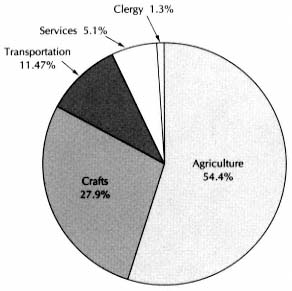
Figure 8.1.
Villaverde, Employment Structure, 1752
| |||||||||||||||||||||||||||||||||||||||||||||||||||||||||||||||||||||||||||||
| ||||||||||||||||||||||||||||||||||||||||||||||||||||||||||||||||||||||||||||||||||||||||||||||||||||||||||||||||||||||||||||||||||||||||||||||||||||||||
| ||||||||||||||||||||||||||||||
Similarly, other parishes sent to the cilla of Villaverde half the tithes on the crops their farmers harvested within its limits. The catastro does not say how much these portions amounted to, but one can obtain a reliable approximation from the tithe book for the years 1773–1811, now in the provincial archive of Salamanca.[7] It breaks down the payments between towns for the years 1776–80 and 1805–7. Table 8.4 shows the different shares for the first period. It separates the payments to the two adjoining despoblados of La Cañada and La Cañadilla, both anexos of the parish of Villaverde, from those to other towns; the former were increasing during the period covered by the tithe book, an indication that the vecinos of Villaverde were extending the land that they farmed in the despoblados. By projecting back from 1776–80, one can estimate the payments to these two places at midcentury. There is no sign of change in payments to or from other towns, and I shall use the same proportions for midcentury as in the table.
We are now in a position to calculate the total harvest from the tithes reported in the catastro. To do so I shall apply the percentages of 1776–
[7] AHPS, Hacienda, libro 167.
| ||||||||||||||||||||||
1800 to the total tithes of 1747–51, with the difference indicated for the two despoblados, and include an estimated payment of the first tither at the earlier period, which no longer went into the partible after 1761.[8] Table 8.5 provides the data and indicates that the total crop, which was ten times the tithes, was 4,688 EFW. This figure is 5.6 percent higher than the 4,441 EFW predicted from the extent and different qualities of land (see Table 8.2), evidence of remarkable accuracy in the catastro's survey. Since the tithe returns are a more exact measure of the harvests, I shall use them and increase the estimate of the net harvest by the same proportion to 3,783 EFW.
How much of the net harvest remained within the town economy depended in large measure on the ownership of the land, shown in Table 8.6 and Figure 8.2. At first sight the distribution recalls that of La Mata, for most of the land belonged to nonresidents and outside institutions, but closer observation reveals significant differences. Outside owners held almost as much as in La Mata, 69.3 percent of the land, compared to 71.4 percent, and similarly, of this share the larger part belonged to owners located in Salamanca city. On the other hand, although ecclesiastical ownership was high in Villaverde, 47.5 percent, it was far less than the 77.5 percent of La Mata. Moreover, vecinos were
[8] See Appendix G.
| ||||||||||||||||||||||||||||||||||||||||||||||||||||||||||||||||||||||||||||||||||||||||||||||||
in a better position, with 19.6 percent compared to 9.8 in La Mata. The vecinos also owned most of the houses, 79 of 116, with another 20 belonging to the parish church and nearby vecinos.[9]
Following instructions, the makers of the catastro reported the rate of rent collected by ecclesiastical owners, which Table 8.7 lists.[10] With a different rate for each quality of land, it is a subtler calculation than the
[9] Villaverde, maest. segl. and maest. ecles.
[10] Villaverde, maest. ecles., f. 325.
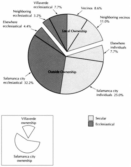
Figure 8.2.
Villaverde, Ownership of Land, 1752
rule of thumb in La Mata of 1 fanega of wheat for each fanega of land, regardless of quality. Unfortunately, I have little data to check its accuracy. Although the records of several monasteries that rented fields in Villaverde are preserved, their leases usually lumped plots outside Villaverde with those in its limits. Only two of those available cover property entirely within the town. The convent of Corpus Christi of Franciscan
| ||||||||||||||||||||||||
nuns owned in Villaverde 1.5 fanegas of first-quality land, 9.5 of second, and 3 of third.[11] The catastro's rule would indicate a rent of 10.125 fanegas of wheat. The convent's accounts for the years 1800–1805 show that the rent was 12.5 fanegas. The tenant fell behind in the bad year, 1803, but made up his arrears with the harvest of 1805.[12] Evidently the convent was not charging too much, although 20 percent more than the reported rule calls for. It also got the horros on its land. The second case involves seven plots bought in 1794 by the nuns of the monastery of Nuestra Señora del Jesús of the Order of Saint Bernard. They had the plots surveyed accurately; there were 3.92 fanegas of first-class land, 3.08 of second, and 0.45 of third. The rule indicates a rent of 8.30 fanegas of wheat; the actual rent from 1795 to 1798 was 10 fanegas, and in 1799 the nuns raised it to 11.5 fanegas. In addition they received the horros.[13] Here the rent was 20 to 40 percent above the rule. Had the rents been raised since the catastro? We do not know, but the next case suggests that this is not the explanation for the disparity.
The nuns of Jesús also owned a group of fields in Villaverde and Pajares, the next town to the north. The holdings in Villaverde consisted of thirty-three arable plots, a meadow, a cortina, and a house. The predicted rent for the plots in Villaverde is 21.125 fanegas of wheat.[14] The predicted rent for its holdings in Pajares is 13.05 fanegas of wheat, for a total in both towns of about 34 fanegas.[15] In 1758 these lands were
[11] Ibid., ff. 201–5.
[12] AHN, Clero, libro 10880, f. 24; libro 10869, f. 47.
[13] AHN, Clero, libro 10668, f. 217r–v.
[14] Villaverde, maest. ecles., ff. 268–81: 5.5 fanegas of first-class land; 9.5 second; 23, third.
[15] AHPS, Catastro, Pajares, maest. ecles., ff. 69r–74r, 199.
| ||||||||||||||||||||||||||||||||||||||||||||||||||||||||||||||||||||||||||||||
rented to a vecino of Villaverde for 46 fanegas of wheat plus the horros. In 1775 the nuns raised the rent to 50 fanegas but dropped it in 1788 to 26, presumably because the lease no longer included all the above property.[16] In 1758 the rent was about 35 percent above that predicted from the information in the catastro.
This limited evidence indicates that the tenants paid more rent than the rule stated in the catastro. In La Mata the rule proved too high; the more complex calculation reported for Villaverde gives results that are probably too low. Under the circumstances, I shall use an estimate for rent 20 percent above that predicted by the rule in the catastro. Table 8.8 lists the property of outside owners and the estimate of the rent they would have collected, 1,050 fanegas of wheat. The total harvest on this property, using the yields shown in Table 8.2, would be 3,225 EFW. Increasing this amount by 5.6 percent, according to the correction derived from the tithe returns, one can predict a total harvest of 3,406 EFW. The rent would then be about 31 percent of the total harvest.
This rate is a surprising amount higher than the 23 percent calculated for La Mata.[17] In both towns the estimated rent is based on evidence from actual rental agreements. If the rule given in the catastro for Villaverde is applied, the rent would be 26 percent of the harvest, and in La Mata it would be 27 percent, almost the same, although the rules were
[16] AHN, Clero, libro 10668, f. 173.
[17] Above, Chapter 7, section 2.

Map 8.1.
Villaverde and Its Environs
NOTE : In the nineteenth century despoblados were incorporated in adjoining
towns. La Cañada and La Cañadilla went to Villaverde. I am indebted to
Angel Cabo Alonso of the University of Salamanca for identification of
the eighteenth-century roads that served Villaverde.
different. Is this pure coincidence, or is it possible that the accepted rates were established some time in the past to produce similar rents but had since been altered by economic forces to the benefit of the farmers of La Mata and the disadvantage of those of Villaverde? Let us keep in mind the possibility of such a development.
At 31 percent of the predicted harvest, the rent paid by the vecinos for the grain fields of the town church and endowments it controlled would be 113 EFW, and for fields belonging to nearby churches, 48 EFW.
An important share of the town land belonged to vecinos of nearby towns, more in fact than to vecinos of Villaverde itself (Table 8.6). As Map 8.1 shows, most of the nearby owners lived in the larger town of Pedrosillo el Ralo, four kilometers to the west. The question arises whether Villaverde was exploited by nearby vecinos or there was a pattern in this area of ownership across town boundaries. Without a full study of the catastros of towns within walking distance, no firm answer
is possible, but a review of the catastros of the three nearest towns reveals that in them the vecinos of Villaverde owned less than half the property that their vecinos owned in Villaverde.[18] I shall therefore estimate that Villaverde's vecinos owned about half as much outside its término as nearby vecinos did in it.
In assigning the income from these lands, one must know who farmed them as well as who owned them. Even though vecinos of Villaverde owned less land outside the town than nearby vecinos did in it, the tithe records indicate that they harvested about four times as much outside as others did in their town (Table 8.5). Obviously even locally owned fields were not always farmed by their owners, and the vecinos of Villaverde had to pay rent to nearby owners as well as to more distant landlords. The lands of nearby vecinos would produce an estimated harvest of 396 EFW, with a potential rent of 123 EFW, at 31 percent of the harvest. From the tithes we know that nearby vecinos harvested about 140 EFW in Villaverde (twenty times the tithes they paid to the parish of Villaverde, Table 8.5), which is 35 percent of the total crop in the fields belonging to them. Villaverde vecinos must have farmed the rest, paying some 80 EFW in rent.
If vecinos of Villaverde owned half as much land outside the town as nearby vecinos in their término, the harvests on these lands would have been about 198 EFW. But the tithe records indicate that Villaverde vecinos actually brought in 556 EFW from outside (twenty times what they paid the parish of Villaverde on outside harvests, Table 8.5). They therefore rented lands outside the término that produced 358 EFW. At the ratio for seed and rent found in Villaverde, their net harvest from outside, after deduction for seed, would be 450 EFW and the rent for these lands would be 111 EFW.
From the tithe records, we have also estimated that the farmers of Villaverde harvested 630 EFW in the despoblados of La Cañada and La Cañadilla. Their net crop after seed would have been about 510 EFW, and their rent, 195. One must remember that on all harvests grown outside the término, half the tithes remained in the town where they were grown.
Besides the tithes, the farmers paid also the first fruits and Voto de
[18] Vecinos of Pedrosillo el Ralo owned land in Villaverde evaluated at 2,098 reales per year; those of Villaverde owned land in Pedrosillo el Ralo evaluated at 607 reales. The corresponding figures for Gomecello are 71 and 40, for Pajares 50 and 356. Totals: outsiders held 2,219 reales' worth in Villaverde, vecinos of Villaverde 1,003 in the other towns. These are the three towns that bordered on Villaverde. AHPS, Catastro, Pedrosillo, maest. segl.; Gomecello, maest. segl.; Pajares, maest. segl.
Santiago, following the same rules as in La Mata. The first fruits averaged over the previous five years at 66 EFW and the Voto at 23 EFW.[19]
Raising animals was an integral part of local agriculture. The catastro lists oxen and cows, horses and pigs. Among the tithes paid were thirty chickens per year, which meant that at least three hundred were born.[20] The catastro does not mention sheep, but there was a shepherd, seventy years old, helped by his sixteen-year-old son.[21] The tithe book occasionally lists the receipt of wool, 90 pounds in 1777, 51 pounds in 1779, 81 in 1781. This represents a shearing of about 750 pounds per year, so that there would have been some 500 sheep, and they were probably there already in 1752.[22]
Following the method described in Appendix K, one can draw up Table 8.9 for the income from raising livestock in Villaverde. It shows a gross income from livestock of 758 EFW. From this one must deduct the cost of pastures. Most of the animals were pastured in the despoblados of La Cañada and La Cañadilla,[23] where there were 186 fanegas of pasture valued by the catastro at 920 reales per year. If this was indeed the amount of the rent, the vecinos paid 66 EFW to feed their animals outside the town.[24]
Breeding livestock was such a central activity of the town that twenty vecinos reported income as dealers in livestock (tratantes y cambistas de ganado ) ranging from 150 to 1,200 reales per year.[25] They included fifteen labradores (who earned 8,800 reales), four craftsmen (2,550 reales), and one man classed only as a tratante (but who declared only 150 reales income from this occupation). The total income from these activities was 11,500 reales per year, 820 EFW. Seven dealt only in mules and four in cattle and mules, while three dealt in pigs, cattle, and mules. Since the town did not produce many mules, the tratantes were dealing to considerable extent in animals raised elsewhere. And since the town was self-sufficient in animals, the dealers sold as well as bought outside. The total local production of oxen, horses (including mules), and pigs was
[19] Villaverde, resp. gen. Q 16, and maest. ecles., f. 323.
[20] Villaverde, resp. gen. QQ 15, 16.
[21] Villaverde, personal de legos.
[22] Sheep in this region produced about 1.4 pounds (libras) of wool each; see Tables 9.3 and 9.6 (748 sheep produced 1,028 lbs. of wool in Pedrollén). In the sierra town of El Mirón, 2,100 sheep produced 3,550 lbs. of wool, 1.7 lbs. per sheep.
[23] Villaverde, resp. gen. Q 20.
[24] I have not used the catastro volumes of La Cañada and La Cañadilla. The provincial summary indicates that these were the pastures in these two towns (AHN, Hac., Catastro, libros 7476, 7477, 7478), and the tithe register lists them as rented to Villaverde farmers.
[25] Villaverde, resp. gen. Q 31; AHN, Hac., libro 7476, letra F, f. 108.
| ||||||||||||||||||||||||||||||||||||||||||||||||||||||||||||||||||||||||
worth 420 EFW. Half of this may have been sold outside by the tratantes (and the rest consumed or used locally) and should not be counted again as town income, so that dealing in livestock brought in a net return to the town of some 610 EFW.
We now have the information needed to calculate the net income from agriculture of the vecinos of Villaverde (Table 8.10). It produces a total of 3,077 EFW.
2
To see how this income was divided among the inhabitants, the best source is the book of tithe rolls, which begins in 1773, twenty-one years after the catastro was completed. The book identifies the tithers as either labradores or senareros, those for whom farming was the main occupation and those who used it to supplement other income. Thirty-two labradores were listed in each of the first two years (thirty-one of them the same individuals), and fifteen senareros (but only eight individuals
| ||||||||||||||||||||||||||||||||||||||||||||||||||||||||||||||||||||||||||
| ||||||||||||||||||||||||||||||
appeared both years). (We recall that because of the two-year farming cycle, one must average each farmer's share of the harvest over a two year period to determine his economic position.) As before, the harvests of the casa excusada and cuarto dezmero are not listed.[26] The fourth tither's harvest can be interpolated between those of the third and fifth, and I project that of the first above that of the second with a difference slightly larger than between those of the second and third tithers. These are only rough approximations, for the evidence from La Mata indicates that once named to one of these positions, a person was usually kept there, although his harvests might no longer entitle him to it.[27]
On this basis Table 8.11 calculates the distribution of harvests of the first two years of the tithe rolls. To project this pattern back to the time of the catastro, one must adjust for the fewer number of men in agriculture at that time. The catastro lists twenty-eight labradores, four less than in 1773–74. It does not say how many senareros there were, but eighteen is a good guess, four fewer than in 1773–74. Table 8.12 readjusts the individual shares of the harvest in Table 8.11 to these lower
[26] The two individuals are identified by name in 1773, 1774, 1775, and 1804.
[27] See Appendix I.
| |||||||||||||||||||||||||||||||||||||||||||||||||||||||||||||||||||||||||||||||||||||||||||||||||||||||||||||||||||||||||||||||||||||||||||||||||||
numbers and then applies the information on income from agriculture to estimate the individual incomes in 1752.
As was done for La Mata (see Table 7.10), one can check the distribution of the individual harvests in Table 8.12 by a distribution based on the number of oxen owned by each labrador, as recorded in the catastro (Table 8.13). The check proves to be rough because the range in number of oxen is not great, but there is consistency between the two calculations. The labradores owned seventy-seven oxen and one draft horse (which may have been hitched with a mule). According to the rule
| ||||||||||||||||||||||||||||||||||||||||||||||||||||||||||||||||||||||||
that one yoke of oxen could plow 22.5 fanegas per year, forty yokes sufficed for 1,800 fanegas of land in a two-year cycle. Villaverde's catastro recorded 1,650 fanegas of arable, but the oxen were also used outside the town.
One can also check the table by the tithes of the fourth tither. These indicate a gross harvest of 252 EFW, which means a net income from harvest of 105 EFW (see Table 8.10). This is below the 130 EFW predicted in Table 8.12 and, if correct, would mean larger harvests for the first three tithers than predicted in the table. We recall that the tithes of the fourth tither of La Mata were also less than predicted (Appendix I). Perhaps fourth tithers fudged on their tithes because the cathedral of Salamanca, to which these tithes went, could not keep a strict control throughout the many towns of the partido or perhaps, as suggested, the "fourth tither" had fallen from fourth place but had not been replaced. In any case, his tithes do not seem adequate evidence to discredit Table 8.12.
In addition, most of the income from raising livestock went to the labradores, who owned the largest number of each kind of animal ex-
cept donkeys; and fifteen of the labradores also dealt in livestock as tratantes. Table 8.12 indicates the estimated income from these activities for the individual labradores.
Out of their gross income, the wealthier labradores had to pay the cost of hired labor. Thirteen labradores had more than one yoke of oxen, ranging from one and a half to three. There were ten jornaleros in the town, to each of whom the catastro assigned wages of two reales per day for 180 days per year, or 26 EFW.[28] One can divide the total wages of the ten jornaleros among the top labradores according to the number of extra yokes of oxen they owned. The approximate results are given in Table 8.12, together with the net income of the labradores from all sources after deducting the cost of labor, and the net income of the senareros from agriculture.
The range of the net income of the labradores is great. The casa excusada, with 315 EFW per year, received ten times the amount of the most modest labradores. How well-off they were depended on the size of their households. The fifteen labradores who were also tratantes had larger households than the others; they averaged 5.2 people as opposed to 3.4. Ten of the fifteen labradores-tratantes had a male servant in the household eighteen years or more of age, and four of them had servant girls. The other labradores had only two male servants and one female servant among them. Neither group had many children, and the two largest households had only 7 members including servants. If, as established earlier, an adequate household income consisted of 12 EFW per person, the average requirements of the labradores-tratantes was 62 EFW and of the others 41. All the labradores-tratantes had more than required, and the first six, with net incomes of 165 EFW or more, could be considered wealthy. At the other extreme, however, at least five of the bottom six families, who had incomes estimated at 31 EFW and 3 or more members (one family consisted of a childless couple), were below the line of comfort.
A comparison with the income of the labradores of La Mata is revealing (see Table 7.11). All these had an income of at least 75 EFW, whereas 40 percent of those of Villaverde were below this level. At the other extreme, 40 percent of the labradores of La Mata can be considered wealthy (over 100 EFW annual surplus above the 12 EFW per person require-
[28] Villaverde, resp. gen. Q 34. The catastro of La Mata says its jornaleros worked 120 days a year. The disparity is too great to be credible, but I follow the information of the catastro. The effect on family income is not great (Table 8.18).
ment), but only 20 percent of the labradores of Villaverde. While the wealthiest labradores in Villaverde were as well-off as their counterparts in La Mata, as a group the labradores of Villaverde did not have the economic strength of those in the nearby town. The most obvious reasons for the difference that have come to light are that the land in Villaverde was less fertile and the proportion of the harvest taken as rent was higher. Although there may have been errors in drawing up the catastros of the two towns, it is hardly likely that all the differences are merely the fault of bad data. In both cases, the rate of rent is based on actual contracts. One can assert with confidence that the labradores of Villaverde were poorer than those of La Mata.
The other people in agriculture skirted the threshold of poverty. These were mostly older villagers, some possibly retired from more active occupations, with smaller families and fewer needs. The shepherd was seventy and had a daughter and a sixteen-year-old son. The four guardas de campo averaged forty-seven years of age, the ten jornaleros forty-two. The youngest were three jornaleros of thirty-two. Most of the jornaleros probably leased a few plots and were senareros as well and had incomes of 6 to 11 EFW from this activity plus their animals (Table 8.12). Almost all these people had families of three; even so, as Table 8.14 shows, they barely eked out an adequate income, and the elderly widowed shepherd did not.
3
La Mata owed much of its well-being to its flourishing sector of muleteers (arrieros). In Villaverde the sector devoted to haulage was much less important. Nine vecinos were arrieros, and so were two adult sons of widows. The individual income of these men depended on the number of animals each had. As in La Mata, the catastro calculated income at two reales per day for each mule and one for each donkey, but whereas the arrieros of La Mata were reported to work 200 days per year, those of Villaverde were credited with only 150 working days.[29] Evidence of lack of reliability in the rough estimates of income in the catastro? Perhaps, but more likely a reflection of a real difference in the two towns. The arrieros of each town, we are told, usually went out as a group and had their established routes. Those of La Mata went to Burgos and Bilbao, carrying the wheat of La Armuña and bringing back fish
[29] Villaverde, resp. gen. Q 32.
| ||||||||||||||||||||||||||||||||||||||||||||||||||||||||||||||||||||||||
| ||||||||||||||||||||||||||||||||
and other products.[30] Those of Villaverde went to Salamanca and Zamora,[31] or south across the sierra to Plasencia and from there east to Madrid and other points in Castile.[32] They had virtually no return freight.[33] The makers of the catastro evidently knew what they were doing in showing less income for arrieros in Villaverde.
In La Mata, we estimated an annual net income from mules of 25 EFW and from donkeys of 12.5, after taking account of the cost of feeding and income from breeding. In Villaverde, if gross income per animal was 75 percent of that in La Mata, the proportion of net income was lower, because the cost of feeding an animal would be more than 75 percent of that for La Mata. The relevant calculations indicate 18.6 and 9.3 EFW as reasonable estimates of annual income from each mule and donkey. These produce Table 8.15, giving the net income of the arrieros from haulage. It is unlikely that many arrieros were also senareros. Juan Mellado, a senarero in 1773, the first year of the tithe rolls, was probably the same person as the richest arriero in 1752, for this was the only person with this surname in the catastro. My estimate of eighteen senareros allows for ten jornaleros and eight artisans, but no arrieros, however, so I shall attribute them no income from this source.
In any case, the available evidence indicates that arrieros' income was marginal. The average family size was 4.5 for complete households, 2.5
[30] Above, Chapter 7, section 5.
[31] Villaverde, resp. gen. Q 32.
[32] Cabo Alonso, "La Armuña," 127–28.
[33] Ringrose, Transportation, 23. His Map 13 identifies only six transport routes in the whole country with two-way loads, and two of these are between La Armuña and Bilbao.
for those of widows. Unless they had substantial income that I have not been able to trace, all but the top four arrieros were below the 12 EFW line. There were none who could live comfortably and have money to save, as the top third of La Mata's arrieros did. Their total gross income from haulage was about 720 EFW;[34] and if, as in La Mata, 75 percent of this represented income from outside the town (a generous assumption since there was a larger harvest in Villaverde and fewer arrieros to take it to market), their contribution to the net income of the community was 540 EFW, about 50 per capita, compared with 75 per capita by the arrieros of La Mata.
Artisans were a more important group in Villaverde, over a quarter of the vecinos. Their income, however, was not impressive. The catastro lists their earnings from their crafts and from other sources: dealing in livestock (as tratantes) or acting as town drummers (tamborileros ) to provide music for local festivals. Four of their names appear as senareros in the tithe rolls of 1773–74. They were probably the same persons, for in 1752 their ages were between twenty-six and forty-two. No doubt these four and other craftsmen farmed on the side in 1752. All these sources of income are included in Table 8.16.
The incomes of the artisans were low, about the same level as those of the arrieros and the bottom half of the labradores. It is true that the catastro's figures are only rough estimates, reported as a daily income and a specified number of days worked per year, but they were an attempt to represent reality and so are very unlikely to have indicated poverty where there was comfort. The blacksmith was "igualado" (that is, he was paid a fixed salary, or iguala, by the town) and had the largest income in the town from dealing in livestock, placing him economically with the first quarter of the labradores. Otherwise, the artisans lived a marginal existence.
The artisans could compensate for their income by having small households, and this they did. The blacksmith, who could afford it, had the only large family, with 2 sons and 5 daughters. Without him, the craftsmen averaged 3.7 persons per household. None but the blacksmith earned enough to think of saving, and the known income of several placed them below the 12 EFW line. Yet they were a large group, obviously producing for a market outside the town itself, although not for an urban market. (The tailors "make clothes for the use of the labrador.")[35] If two-thirds of their income as craftsmen came from outside
[34] From four mules and fifty-nine donkeys.
[35] Villaverde, resp. gen. Q 33.
| ||||||||||||||||||||||||||||||||||||||||||||||||||||||||||||||||||||||||||||||||||||||||||||||||||||||||||||||||||||||||||||||||||||||||||||||||||||||||||||||||||||||||||||||||||||||||||||||||||||||||
| ||||||||||||||||||||||
the town for goods sold or labor done elsewhere, they brought in about 720 EFW to the economy of the community.
Finally, Villaverde had a small service sector. The net income of the butcher (oficial de carnes mayores ), after paying the town 18 reales rent per year for his shop, was a bare 25 EFW, but he must have eaten meat and offal without cost. He lived alone with a daughter. The farrier made "between one activity and another" about 43 EFW. He was thirty-eight, and his wife was the only other member of his household. In contrast, the surgeon-barber received an annual income (iguala) from the vecinos of eighty fanegas of wheat. Only twenty-four, he supported a wife and a brother-in-law. Someone in the town earned additional income as sacristan, 331 reales from first fruits and 150 reales for ringing the church bell. He thus added 34 EFW to his income, but we do not know who he was.[36] The service sector did not bring in income from outside the town.
In economic terms, the priest also belonged to this sector, but don Francisco Repila's income set him apart from the others. It came entirely from his benefice, for his only possession was a donkey (Table 8.17). Don Francisco's household consisted of his mother, a sister, and a maid. His income of 210 EFW was below that of the top labradores. Nevertheless, the considerable material rewards of his office, of which the catastro does not tell the full story for it includes nothing for services
[36] Villaverde, resp. gen. QQ 32, 33, and maest. segl.
| |||||||||||||||||||||||||||||||||||||||||||||||||||||||||||||||||||||||||||||||||||||||||||||||||||||||||||||||||||||||||||||||||||||||||||||||||||||||||||||||||||||
| |||||||||||||||||||||||||||||||||||||||||||||||||||||||||||||||||||||||||||||||||||||||||||||||||||||||||||||||||||||||||||
conducted for private individuals, combined with his sacramental role to endow him with unique local prestige, similar to that of his colleague, don Juan Matute, in La Mata.
To conclude our survey of the income of the different households of Villaverde, Table 8.18 and Figure 8.3 plot their relative position in a socioeconomic pyramid. In studying it, one must always keep in mind that it is created out of the income distribution that can be identified in the catastro and tithe records and that in any small rural community, much real income would have changed hands without being covered by any formal acknowledgment or occupational label that an official survey could categorize.
4
Because of all these hidden internal transfers of income, a final assessment of the well-being of Villaverde needs, besides the income of the
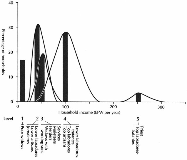
Figure 8.3.
Villaverde, Socioeconomic Pyramid, 1752
NOTE : This is a bar graph based on Table 8.18, with an indication
of dispersion. It is not a set of frequency distributions.
various sectors and individuals, an estimate of the condition of the economy as a whole. The sources of income have been seen, but of the payments made to the outside world only the rents have been established. Most of the others were religious in nature, and of these the most substantial came out of the tithes (Table 8.3). Two-ninths of the partible tithes, the tercias reales, went to the University of Salamanca. Three-ninths went to the owner of the prestamo of the town, the Colegio de San Gregorio of Valladolid, but the colegio was required to give one-twentieth of this payment to the cathedral of Salamanca. These two shares of the partible were 104 and 156 EFW. (Of the remaining four-ninths, three went to the parish benefice and one to the fabric.) The tithes of the fourth tither (cuarto dezmero) went to the cathedral of Salamanca, and the outside owners of lands free from tithes took the horros on the lands. The minor tithes (diezmos menudos ) on animals and wool were divided in the same way as the partible; of a total of 8 EFW, 4 left the town. The first fruits, 66 EFW, were all taken away, two-thirds to the holder of the "beneficio simple servidero," the second priest of the parish, who had chosen not to reside in the town, and one-third to the aforementioned Colegio de San Gregorio. The Voto de Santiago, 23 EFW, went to the cathedral of Santiago de Compostela.[37] Finally, as in the case of La Mata, one can estimate that about one-quarter of the income of the parish church was spent outside the town. Taking into account its share of the tithes, the horros, and the rent on the plots that belonged to the church and the endowments attached to it, the amount leaving would be 26 EFW.
The final deductions are obligations that the town council met for the vecinos as a whole. It paid a hospital in Salamanca 2.5 fanegas of wheat and 1 fanega of garbanzos (5 EFW), presumably for the right to send its sick to the hospital, and 206 reales (15 EFW) variously to a preacher for Lent, the insane asylum of Valladolid, and the bula de la cruzada. The administrators (sexmeros) of the partido of Salamanca received 380 reales (27 EFW).[38] (La Mata must also have paid them its dues, but its catastro overlooks the item.) The town council also paid royal taxes, established as an annual fixed sum through encabezamiento (Table 8.19). These taxes were almost nine times as high as those reported by La Mata, which in fact did not mention alcabalas y cientos (a sales tax originating in the Middle Ages). As with its high rents, Villaverde appears to have been burdened with charges that dated from an earlier, more prosperous time.
[37] All from Villaverde, resp. gen. Q 16 and maest. ecles., ff. 314–23.
[38] Villaverde, resp. gen. Q 23.
| ||||||||||||||||
The information is now at hand to establish the best estimate of the net annual income of the town, and it is 4,919 EFW (Table 8.20).
The family lists of the catastro, which appear reasonably complete for Villaverde, give a total population of 357[39] and a per capita income of 13.8 EFW. Although this is above the 12 EFW line, it is only about 70 percent of La Mata's per capita income. Most families lived frugally, while the poorer labradores, the jornaleros, and most artisans (Level 2 in the socioeconomic pyramid) were on the borderline of an adequate income. Only three labradores-tratantes and the priest (Level 5) were wealthy, while the remaining twelve labradores-tratantes and the blacksmith (Levels 4A, 4B) were well-off. A poorer economy than La Mata's, Villaverde's was also less egalitarian, for the wealthy labradores stood out above the body of the community. These men almost had to save or use their surplus to perform pious works. As husbandmen, they would be eager to buy land if it came on the market.
5
Such an economy did not offer encouragement for demographic expansion. The majority of the families were small; only the upper labradores, the muleteers, and the linen weavers averaged more than four in a household. Yet the population was not particularly old, as the age structure in 1752 reveals when compared to that of La Mata (Table 8.21 and Figure 8.4). Nevertheless, even though the population of La Mata was expanding rapidly, the available census information indicates that that
[39] Villaverde, personal de legos and personal de eclesiásticos.
| ||||||||||||||||||||||||||||||||||||||||||||||||||||||||||||||||||||||||
| |||||||||||||||||||||||||||||||||||||||||||||||||||||||||||||||||||||||||||||||||||||||||||


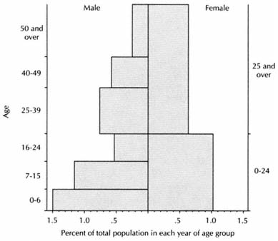
Figure 8.4.
Villaverde, Population Structure, 1752
NOTE : Since there is no limit to the top age groups, a span of
seventeen years for males is used for convenience only.
| |||||||||||||||||||||||||||||||||||||||||||||||||||||||||||||||||||||||||||||||||||||||||||||||||||||||||||||||||||||||||||||||||||||||||||||||||||||||||
of Villaverde was almost stagnant (Table 8.22). These counts indicate that Villaverde was slightly more populated in the sixteenth century (its impressive church looks as though it were built about 1600), declined slightly in the seventeenth century (the vecinos of 1712 are probably underreported), and recovered little in the eighteenth century. The catastro and census of 1786 are the most reliable counts and give full population. Over this thirty-four-year period, while La Mata grew 39 percent, Villaverde declined 3 percent. But demographic stability was not new to Villaverde in the second half of the eighteenth century.
One of the methods employed to keep the population down was late age at marriage. In La Mata 46 percent of the women and 44 percent of the men aged sixteen to twenty-four were married in 1786, in Villaverde only 10 and 12.5 percent respectively (Figure 8.5).[40] Six laymen over twenty-five were bachelors, 7 percent; in La Mata 3 percent. While Villaverde's population was slightly younger in 1786 than in 1752, it was
[40] For data on the 1786 census of Villaverde, see Appendix N, Table N.6.
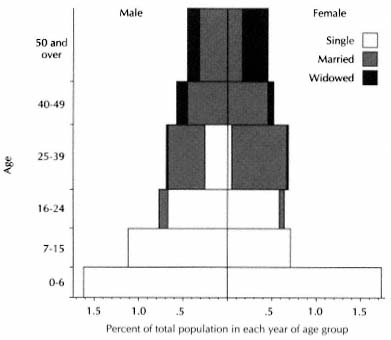
Figure 8.5.
Villaverde, Population Structure, 1786
NOTE : Since there is no limit to the top age group, a span
of seventeen years is used for convenience only.
now old by comparison with La Mata's (see Table 7.17). Twenty-seven percent were forty and over, in La Mata 18 percent. New people arrived in Villaverde as in La Mata, but not so many. Of forty-one regular tithers in 1798, ten had last names not present in 1752; in La Mata one-third were new. These features reveal why Villaverde was demographically stationary while its prosperous neighbor multiplied.
Villaverde also followed the practice of sending young girls away to serve—there were only twenty-two girls present in 1786 in the 7–15 age group compared to thirty-five boys. In La Mata they returned at about the age of sixteen and married soon, but in Villaverde they came back older—there were twenty females and twenty-four males in the 16–24 age group. There is a strong indication, moreover, that young men were also absent in the 16–24 age group both in 1752 and 1786 (see the age pyramids, Figures 8.4 and 8.5). It will become evident later that many unmarried young men served in the despoblados and alquerías of Salamanca, and very likely this is where some of those of Villaverde went to
| ||||||||||||||||||||||||||||||||||||||||||||
work.[41] The small size of households was the result not only of births averted but of an absence of part of the families.
The vecinos were also seeking other ways to improve their lot. One way was to move into more rewarding forms of work. The list of occupations in the census of 1786, although not so detailed as the catastro, gives evidence of this change (Table 8.23). Along with the jornaleros, the artisans had made up the poorest sector in 1752, and the next generation responded by leaving the trades. In La Mata artisans were also poor, and they disappeared by 1786. The depressed state of the crafts was apparently a general phenomenon in central Spain in the eighteenth century. Pierre Vilar has concluded from a study of the provincial returns of the catastro that throughout the Castilian meseta the crafts were in the last stages of a long decline.[42] The very increase in transportation that benefited the muleteers of La Armuña destroyed the monopoly of its artisans over local markets and hastened their disappearance.
Muleteering had absorbed much of the decline in craftsmen in Villaverde. There were five more arrieros in 1786 than in 1752. Their mean income had been slightly higher than that of artisans in midcentury, and it was a calling whose income did not decline in the next decades. Farming too was drawing more people. The census lists five more labradores, and the tithe records give independent confirmation that their number
[41] See below, Chapter 18, section 3, and esp. Figure 18.1.
[42] Vilar, "Structures de la société espagnole," 435–39.
| ||||||||||||||||||||||||||||||||||||||||||||||||||||||||||||||||||||||||||||||||||||||||||||||||||||||
was increasing. By the mid-1790s there were sixteen more labradores than at the time of the catastro, an increase of 32 percent.[43] By giving up crafts in favor of muleteering and husbandry, the community was specializing in areas of local comparative advantage.
In La Mata the increase in the number of farmers led to the sowing of more labor-intensive crops of the pulse family. In Villaverde, too, the vecinos experimented with various crops (Table 8.24). Between the catastro and the five-year period 1778–82, they reduced the amount of algarrobas, a fodder, and planted more wheat, with a resulting 17-
[43] In the early 1770s the tithe register lists about thirty-two labradores, in the mid-1780s about thirty-five, in the mid-1790s thirty-seven, and the number peaked at forty-four in 1800 (52 percent above 1752) After the epidemic of 1803–4, it declined to thirty-six in 1806 and rose to thirty-eight in 1808.
percent growth in the value of the harvest (at 1752 prices). In the next five years they tried a much larger garbanzo crop (in 1785 it was 28 percent of the harvest), the same years when La Mata increased its output of garbanzos. The total yield within the término was disappointing, only 11 percent above 1752 figures, and they abandoned the experiment. Between 1788 and 1797, they emphasized wheat again and planted pulses in more modest quantities. This proved to be the most profitable mixture, for the value of harvests was higher than ever.
Nevertheless the value of harvests grown within the town limits increased less rapidly than the number of labradores, but the tithe records indicate that the vecinos had another card up their sleeves. At the time of the catastro, the estimate of the vecinos' crops from neighboring towns was 556 EFW and from the despoblados of La Cañada and La Cañadilla 630 EFW, for a total of 1,186 EFW (Table 8.10). The tithe returns show that the outside harvests increased as follows (in EFW value and indexed against 1747–51):
|
By the end of the century, Villaverde farmers were harvesting over three times as much in neighboring towns and despoblados as at midcentury.
Most of the increase came from La Cañada and La Cañadilla. In two separate periods, 1776–80 and 1805–7, the cillero of Villaverde kept a detailed record of the tithes paid to outside towns for crops harvested in them instead of giving only a total figure for these payments. In the three intervening decades, the crops harvested by Villaverde farmers in nearby towns rose from about 625 EFW to about 900 EFW, but at the same time the harvests in La Cañada and La Cañadilla went from about 865 to about 3,900 EFW (Table 8.25). The Marquesa de Castelar, who lived in Madrid, owned 80 percent of the 974 fanegas of La Cañada, while the Encomienda of San Juan de Barbalos of Salamanca owned about 75 percent of the 367 fanegas of La Cañadilla.[44] Absentees, they would be glad to have the land of the despoblados broken to bring in more rent.
[44] For the area, AHN, Hac., Catastro, libro 7476, letra D; for the owners: AGS, Dirección General de Rentas, Unica Contribución, Mayor Hacendado, libro 536.
| ||||||||||||||||||||||||||||||||||||
If one considers the net income from harvests rather than the gross harvests, the growth in the two despoblados is even more impressive. The tithe book occasionally mentions the rent paid by the vecinos. In 1789 the rent for La Cañada was 520 fanegas of wheat and 180 of barley (total 610 EFW). In 1803 it was raised to 640 fanegas of wheat but was lowered to 600 after the bad harvests of 1803–4. For La Cañadilla the rent was 180 fanegas of wheat in 1801.[45] Subtracting rent, tithes, and seed (19 percent of gross harvest), the net return from harvests of the Villaverde farmers in the two despoblados was 1,990 EFW in 1805–7. The estimate for 1752 was 252 EFW;[46] it was now eight times as much.
The harvests of 1805–7 were unusually good and do not provide a representative picture of the situation at the turn of the century, for in good years the tenants profited more. Nevertheless, the farmers of Villaverde obtained a major increase in their harvests by exploiting the two despoblados. They were breaking ground where previously there had been pastures. The development was similar to that of La Mata and its anexo Narros, but with an important difference. The labradores of La
[45] From the entries for La Cañada and La Cañadilla for these years. I base the decline after 1804 on the decline in horros for these despoblados, which were 42 2/3 fanegas of wheat in 1803 and 40 in 1807. The records indicate that the horros were 1/15 of the rent.
[46] Table 8.10. Net harvest 510 EFW, less rent 195, and tithes 63.
Mata extended their farming into the despoblado of Narros until, in 1789, twelve vecinos moved to Narros and formed the core of a new town. Thereafter La Mata lost this resource. The farmers of Villaverde also turned to despoblados anexos for new land, but they did not move out of their town, so that the new fields added to the local income. These are two specific examples of how new land was assarted in Spain in the second half of the eighteenth century and how the economic condition of the local population changed as a result.
The evolution of the farmers' income can be followed by considering their total harvests inside and outside the town limits (Table 8.26). The harvests grown within the término by nearby vecinos almost disap-
| ||||||||||||||||||||||||||||||||||||||||||||||||||||||||||||||||||||||||||||||||||||||||||||||||
peared by the 1790s. The residents of neighboring towns who owned plots in Villaverde must have given up farming most of them and rented them to vecinos of Villaverde. With this additional harvest and those they brought in from outside, the farmers of Villaverde had between 50- and 60-percent larger harvests than at the time of the catastro. Meanwhile the number of labradores increased by a third, from twenty-eight in 1752 to thirty-seven in the mid-1790s.[47] Since the relation between the gross income and the net income from harvest probably changed little, the labradores had managed to raise their per capita income, not because of their experiments with different rotations but because of the new leases they had obtained within the término and outside it.
At the same time, the tithe rolls show that the disparity in income among labradores had declined since midcentury. In 1773–74 the first three of thirty labradores gathered 23.9 percent of the harvest. In 1798–99, the first four of forty-two gathered only 17.6 percent of the harvest.[48] A comparison of the net income from harvest of the top half of the labradores in 1752 (estimated from the harvest distribution of 1773–74) and 1795 gives the results in Table 8.27. The income curve had flattened out. The top labradores had noticeably less income than in 1752, but the income of those in the middle had risen. There are no figures for the end of the century on income from livestock, dealing in cattle, or cost of labor. In 1752 the total income of the first tither was 25 percent above his net income from harvest. This proportion increased as one went down the rank order until in the middle range it was 50 percent, because the share of work done by hired labor was progressively less. (Below these ranks, the labradores did not deal in livestock, and the proportion fell again, Table 8.12.) If this pattern still held true at the end of the century, then the income curve for the top half of the labradores was even flatter than Table 8.27 indicates.
The overall effect of the changes in occupational structure and farming activity can be observed by summing up the individual changes in the town income (Table 8.28). The net town income had risen about 30 percent. In 1786 the population was 346; in 1826 it would be reported as 394 (Table 8.22). One can interpolate for 1795 a population of 357, the same as in 1752, so that per capita income also rose 30 percent, from 13.8 to 17.9 EFW. These figures are only approximations, of course, for there are many unknowns. Income from livestock breeding and trading and the rate of rents inside Villaverde have been held con-
[47] Table 8.1 and n. 43 above.
[48] The crop of the casa excusada is estimated.
| ||||||||||||||||||||||||||||||||||||||||||||||||||
stant for lack of information. Additional information would undoubtedly change the estimate of per capita income at the end of the century, but not necessarily down, and if down, not enough to wipe out known gains.
Although part of La Armuña, Villaverde had had a relatively depressed economy at midcentury. Now it was flourishing. The vecinos had used with success the various means at their disposal to improve their economic position: sending their sons and daughters away to work, marrying late, moving into more profitable occupations, experimenting with different mixtures of crops, taking over leases of arable plots from outsiders, and above all breaking new ground in the neighboring despoblados. It was their good fortune to live next to vacant places with fertile land that needed only cultivation to make it produce, and to obtain their use for a modest rent. Those who benefited were the middle and lower-level farmers, for the most prosperous labradores lost some in the changes. About twenty labradores, perhaps an artisan and an arriero or two, and the priest would find it natural to put some of their income into savings, but there would be few strong fortunes when disentail began.
| ||||||||||||||||||||||||||||||||||||||||||||||||||||||||||||||||||||||||||||
6
The first sales in Villaverde were concluded in September 1799,[49] and the last of which I have a record took place in May 1806.[50] Within this period 221 of the 1,354 arable plots were sold and 9 out of 101 meadows: 19 percent of the land according to its value. Two houses were also sold.[51] Between the making of the catastro and the disentail the proper-
[49] AHPS, Contaduría, libro 850, f. 404r.
[50] Ibid., libro 856, f. 152r.
[51] Most of the properties can be identified in the catastro, but because this document does not give accurate names of all the religious institutions that owned land in Villaverde, some can only be identified on the basis of size, quality, and number of plots involved andby a process of elimination. Three plots sold do not appear to have been recorded in the catastro at all, but their value can be calculated from their size and quality. The Villaverde sales are in the following sources: ibid., libro 850, ff. 400v, 404r; libro 851, ff. 154r, 162v, 165r, 181v–191r; libro 852, ff. 123r–125r, 131r–137r; libro 853, ff. 112v–117r; libro 854, ff. 57v–58v; libro 856, f. 152r–v. Sales recorded in Madrid not entered in Contaduría are C1291, C12681, C15981. C19980, C31845, C31872. Vecinos of Villaverde bought some lands outside the town: AHPS, Contaduría, libro 851, ff. 94r–95v, 223r, 253r, 285v; libro 853, f. 102v; libro 855, f. 32r; libro 856, ff. 94r, 97r.
ties of four laymen (31 plots, 1 meadow, and 1 house) had been transferred to religious endowments and were among those disentailed.[52] In two cases these properties were purchased by vecinos of the same town as the 1752 owner, so that there was no net change of type of owner.
The situation after the disentail in 1808 is compared to that of 1752 in Table 8.29 and Figures 8.2 and 8.6. The change in ownership of land was not so extensive as in La Mata, where 42 percent of all land changed hands. The main cause of the difference was that ecclesiastical endowments owned less land in Villaverde, for they also lost massively here, 38 percent of their land being sold. The parish church and its funds were most affected, losing 53 percent of their property. In absolute terms, however, the religious institutions of Salamanca suffered most: their share of the town property fell from 33 to 22 percent.
A more significant difference between the two towns was in the buyers. La Mata's vecinos bought 55 percent of the property sold, Villaverde's only 16 percent. Vecinos of towns near La Mata bought 8.5 percent, vecinos of towns near Villaverde only 2.3. Nearby vecinos had made two bequests of land in Villaverde to religious foundations since 1752, and this land was now bought by residents of Salamanca, with the result that the share belonging to nearby vecinos declined by a fifth. Disentail did help the vecinos of Villaverde redress their position vis-à-vis their neighbors, extending to ownership a process that had been going on in rentals for several decades. In the sales Villaverde farmers acquired twenty-two plots and a meadow outside the término, while nearby vecinos bought only seven plots in Villaverde. The gain was modest, and on the whole the disentail hurt the town economy slightly. By contrast in La Mata the value of land in local hands almost doubled.
The massive buyers in Villaverde were residents of Salamanca, who
[52] Twenty-two plots owned in 1752 by the priest of Gomecello, Villaverde, maest. ecles., ff. 213–20; sold, AHPS, Contaduría, libro 851, ff. 154r–158r; two plots owned in 1752 by a vecino of Salamanca, Villaverde, maest. segl., ff. 217–31; sold, Contaduría, libro 851, f. 186v; four plots, one meadow, one house owned 1752 by a sister and brother in Pedrosillo el Ralo, Villaverde, maest. segl., ff. 275–79, 283–87; sold, Contaduría, libro 850, f. 404r; and three plots probably owned in 1752 by a vecino of Espino de la Orbada, Villaverde, maest. segl., f. 323, sold, Contaduría, libro 853, f. 115v.
| ||||||||||||||||||||||||||||||||||||||||||||||||||||||||||||||||||||||||||||||||||||||||||||||||||||||||||||||||||||||||||||||||||||||||||||||||||||||||||
bought 64 percent of the property sold and raised their share of the village's land from 25 to 37 percent. Residents of other distant places also increased their share. Among these individuals was don Francisco Alonso y Moral of Salamanca, one of the largest buyers in the province. He made five purchases totaling sixty-three plots and four meadows, 4.7 percent of the property in the town, as well as a house. Don Lorenzo Piñuela, a priest and prebendary of the Salamanca cathedral, in two purchases acquired forty-two plots, while don Cosme de Trespalacios, an advocate of Madrid, bought thirty-six plots and a meadow. Together these three gentlemen acquired two-thirds of the land sold in the town. We shall meet them again in Chapter 20, when we consider the persons who obtained most from the disentail.
Thirty-two people bought land in Villaverde. Table 8.30 gives their identity and the percent of the land in the town that each bought. The list shows a clear pattern. Residents of Salamanca and Madrid dominate the top quarter; they are seven of the top eight buyers. Vecinos of Villaverde make up most of the next quarter. Those in the bottom half of the
| ||||||||||||||||||||||||||||||||||||||||||||||||||||||||||||||||||||||||
| ||||||||||||||||||||||||||||||||||||||||||||||||||||||||||||||||||||||||||||||||
list, people who mostly bought only one or two plots, had scattered residences, two certainly and two probably in Salamanca, one in Valladolid, and eight in nearby towns.
Chance did not dictate this pattern. On the whole, lands were purchased by residents of the place in which the religious institution that owned them was located. Twenty-seven of the 28 plots and all 3 meadows that the vecinos of Villaverde bought belonged to the funds of their church. Residents of Salamanca bought most of the holdings of Salamanca institutions, all but 34 of their 148 plots (29 of the other 34 went to Trespalacios, a vecino of Madrid who soon was to move to Salamanca). Vecinos of Villaverde would have found it difficult to bid for most of these properties, for they formed parts of endowments that consisted of plots scattered over various towns and, sold in blocks, were beyond the means of any local farmer. One may recall, however, that two buyers of La Mata were able in at least one case to bid on and buy those plots that lay within their town and neighboring Narros of a large endowment that spanned other towns. Vecinos of Villaverde did not achieve any such success. And when the large property of a confraternity of Villaverde, 25 plots and 2 meadows, went on sale, Alonso y Moral stepped in to acquire it.[53] He had to pay more than the assessed value in hard currency to get it, seventeen thousand reales, which he would not have done unless forced to by competing bidders. One suspects that the vecinos made a concerted effort to get these lands but failed before his wealth. In comparable circumstances, the vecinos of La Mata obtained the vast property in their término of the General Hospital of Salamanca.
Nine vecinos bought land in the town, two of them and five others bought land outside. Among these fourteen were four women. What can we tell about them? Our main source of information is the tithe book; except for two of the women, all their names appear in it at sometime or other. They were seven labradores, two labradoras, two senareros, and a priest. That is, nine of the fourteen were already full-time farmers.
The largest purchaser was the priest, don Alonso González. The parish supported two clergymen, the curate and the beneficio simple servidero, holder of a capellanía without specific duties. The census of 1786 identifies don Alonso as the latter person. In 1752 the holder of this capellanía had not been resident, but don Alonso's name appears on the tithe register as a senarero from 1774 to 1797. He bought one plot in
[53] AHPS, Contaduría, libro 853, ff. 112v–114r.
1800 for 7,700 reales, which had belonged to the benefice he held;[54] the same year he headed a group of six buyers who purchased two plots in Villaverde and ten plots, one meadow, and two vineyards in nearby towns.[55] These properties had formed the endowment of another capellanía of Villaverde, which don Alonso may also have held. The purchase seems to have been a family affair: besides don Alonso there were three other Gonzálezes, Antonio and Manuel, labradores of Villaverde, and Josepha. The two other buyers were María and Isabel Albarez, sisters perhaps, the last a vecina of Negrilla. They paid 30,620 reales, a respectable sum. We do not know the source of this capital or how much each person's share was. Don Alonso had the income of his benefice; Antonio and Manuel were small labradores. Antonio disappeared after 1802, and Manuel died after the harvest of 1804. The priest was evidently the driving force of the group. He was no longer farming, probably because of his age, and so he rented his newly purchased fields.
Several of the other labradores who bought lands were among the upper third of the farmers, and it is easy to explain their resources. Manuel Romo Borrego, who spent about 3,900 reales for three plots and a meadow as his share of a purchase made in 1801 by three vecinos (one of whom, Manuel González, has already been mentioned), was an elderly and distinguished member of the community.[56] We first find his name simply as Manuel Romo in 1766, when he shared a lease for the lands of the monastery of Discalced Franciscan Nuns of Salamanca in Villaverde and six surrounding towns.[57] His name is regularly in the tithe book from its inception in 1773, and in 1786 he signed the census return as one of the two alcaldes of the town. He was second tither in 1798–99, with an annual net income from harvest in excess of 150 EFW. At 1800 prices (43 reales for a fanega of wheat in Salamanca) he could have had much more money put away than he spent on his purchase. Manuel Romo Martín, a tither since 1786 (his appearance was the cause of the other Manuel Romo adding his matronymic surname Borrego), was the third of the men making the joint purchase in 1801. He bought four plots for about 2,800 reales. In addition he and Gerónimo Romo together purchased two plots in Pajares, the next town to the north, paying 5,170 reales.[58] Manuel Romo's net income from harvest of 135 EFW would have permitted him to save the total of these
[54] Ibid., libro 851, f. 162v.
[55] Ibid., ff. 94r, 182v, 223r, 253r, 385v.
[56] Ibid., libro 852., ff. 133r–134v.
[57] AHN, Clero, libro 10854, ff. 111–21.
[58] AHPS, Contaduría, libro 856, f. 97r.
purchases by himself in five years. Since Gerónimo Romo appears to have been the heir of Manuel Romo Borrego (on the latter's death, he took over his lease to the lands of the Franciscan nuns), he could easily have paid whatever his share was. The labradora Juana Encinas was the widow of Juan Rodrigo, who died in 1798.[59] Rodrigo had been on the tithe register since its inception, and in 1786 he signed the census as the second alcalde. Before his death he had risen to be third tither, just below the other alcalde. When his widow first appeared on the tithe lists in 1798–99, she was sixth, having given up some of his leases. Her net income from harvest averaged about 135 EFW. In 1803 she bought four plots for 5,409 reales;[60] she would not have had trouble financing the purchase.
Where the others got their money is less clear. Josef Carvayo, fourth largest buyer among those of Villaverde, was thirteenth in the ranking of harvests for the years 1798–99 with an annual net income from harvest of about 120 EFW. In 1801 he bought six plots in Villaverde for 12,100 reales.[61] Perhaps he saved forty fanegas of wheat a year, at current prices over an eighth of his purchase, but since prices had risen recently, his purchase represented a minimum of nine or ten years' savings, or less if he paid in vales reales (the contaduría records do not specify the form of currency). He had been on the tithe rolls since 1791, but one suspects that he had an inheritance or other income. Mariana Martín, the other labradora, bought five plots in Pajares in 1806, paying 5,000 reales.[62] She first appeared in the tithe rolls in 1804; in 1807–8 she was sixteenth tither, putting her at the top of the group that netted about 100 EFW in 1795. It would have been hard for her to save the price of her fields; she was probably a widow with inherited wealth. The origin of the capital of Francisco Laso, the last of the labradores who bought land, is the most difficult to understand if it came only from farming. He appeared on the tithe rolls in 1798 almost at the bottom of the labradores. In 1803 he bought six fields lying outside the town, four of them in La Cañada and La Cañadilla, paying the relatively modest sum of 2,620 reales.[63] Farming could hardly have provided his savings; did he engage in other activities? We do not know.
I have classed the other two local purchasers as senareros, although
[59] She took over his lease to the lands of the monastery Nuestra Señora del Jesús in 1799 (AHN, Clero, libro 10668, f. 217r–v).
[60] AHPM, C31872.
[61] AHPS, Contaduría, libro 852, f. 132v.
[62] Ibid., libro 856, f. 94r.
[63] Ibid., libro 855, ff. 32r, 32v.
the identity of one is in doubt. This is Manuel Martín, who paid 6,250 reales in hard currency for a large plot in 1803.[64] His name appears only once in the tithe book. in 1801 as a senarero. Was this unlikely person the buyer, or did the notary in Madrid corrupt the name of Manuel Romo Martín the labrador, who could easily have added this to his other acquisitions? There is no doubt about the identity of the second senarero, Cayetano Prieto. He first paid tithes in 1800. In 1802 he bought five plots and two meadows in two separate purchases, paying altogether 3,500 reales. Furthermore he paid this in hard currency at more than the minimum price; he had beaten out other bidders.[65] His case is particularly interesting. Listed as a senarero until 1806, he appeared as a labrador in 1807 and 1808. In 1798–99 his harvest was about 38 EFW; in 1807 it was 145 and in 1808, 117. Yet the plots he bought produced only 10.5 fanegas per year in 1752, so that most of his harvests in 1807–8 came from rented lands. Whatever his profession before the disentail, he seized the opportunity to buy land and went on to become a labrador.
Prieto's case reveals the economic mobility induced by the sales, not as striking in Villaverde as in La Mata but clear in some cases. Manuel Romo Martín had the ninth harvest in 1798–99; by 1807–8 he was sixth. Josef Carvayo was even more successful: number thirteen in 1798–99, he rose to number two in 1801–2 and was still there in 1807–8. One recalls that his resources are not clear; it is clear that he had great individual drive. At a lower level, Francisco Laso, among the poorest labradores in 1798–99, after his purchase in 1803 rose to be tenth by 1807–8. Two purchasers did not advance, but in both cases their age can account for their declining harvests. The widow Juana Encinas, number six in 1798–99, fell to number twelve in 1807–8. Since her late husband was already farming in 1773, she was probably getting too old to administer all her leases and passed on some to others. The alcalde Manuel Romo Borrego was number two in 1798–99, dropped to number seven in 1801–2, and died after the harvest of 1803. He had been farming since at least 1766; age and infirmity may have forced him to restrict his activities.
In none of these cases do the lands purchased alone account for the change in status. Josef Carvayo's six plots produced 13.5 fanegas of wheat in 1752, his gross harvests went from about 245 EFW in 1798 to almost 700 in 1807–8. His is only the most striking case. As in La Mata, the purchase of lands evidently made a farmer a more attractive
[64] AHPM, C31845.
[65] Ibid., C19978, C19979; AHPS, Contaduría, libro 853, ff. 114v–115r.
tenant, and he could extend his leases at the expense of his more passive neighbors. Here, as in La Mata, disentail reversed the trend toward flattening out the income curve of labradores. In 1798–99 the top tither on the rolls (second after the casa excusada) paid 4.3 percent of the tithes collected; in 1807–8, 6.0 percent. The top five tithers listed in 1798–99 paid 20 percent of the tithes; in 1807–8, 26 percent.
Most of the purchasers were in the top half of the labradores, those with excess income, but they were scattered through this group. Only three of the top ten in 1798–99 bought land. They included number two and the widow of number three but not the head of the casa excusada nor the cuarto dezmero.[66] The well-to-do of the town benefited as a group but not all the richest individuals, only those who leavened their resources with personal ambition.
Religious institutions and endowments had owned 48 percent of the land; their share was reduced to 32 percent. In La Mata the transformation favored the town. In Villaverde this was not the case; after disentail the land controlled by the town, its church and residents, including land outside the término, had declined slightly. The formula established earlier indicates that the rent paid by the vecinos to nonresident owners increased about twenty fanegas of wheat per year as a result of the sales. The amount is small, hardly affecting the town economy, but it is symptomatic of the fact that desamortización did not help Villaverde. The wealthy citizens of Salamanca, by acquiring more than the churches of the city lost, raised the city's share of Villaverde slightly. Villaverde remained as much an economic dependency of Salamanca as before, despite the gains it had made in the second half of the eighteenth century.
At first sight, the failure of Villaverde to do better comes as a surprise when one considers the success of La Mata. At this time their populations were about the same, but the vecinos of Villaverde spent only about 74,000 reales on disentailed land, those of La Mata 251,000. La Mata's major success, the purchase by sixteen vecinos of the properties of the General Hospital of Salamanca, for which they paid 174,000 reales, was led by a man addressed as don who was a newcomer to the town. This man may have brought a major share of this capital with him. Nevertheless, one would have to credit the other vecinos with providing at least 150,000 of the 251,000 spent, twice the amount of those of Villaverde.
The vecinos of Villaverde could not compete with the buyers of Sala-
[66] The casa excusada and cuarto dezmero are identified in the tithe roll of 1804; they were Manuel Escudero and Antonio García. Neither was a buyer.
manca for large blocks of properties scattered across a number of towns, but they let escape lands in their own town that were easily within their reach: eleven plots and four meadows bought in 1800 by a resident of Salamanca for only 9,285 reales, two small plots of first quality land that went to another buyer in Salamanca in 1801 for 800 reales, and the only properties of the General Hospital in Villaverde, seven plots, bought by a vecino of Salamanca in 1806 for only 8,150 reales.[67]
Since the middle of the century, the vecinos had improved their economy substantially. When disentail began, their estimated per capita income of 17.5 EFW was not far below that of La Mata, 20 EFW. Yet they did not take advantage of the royal decree as the vecinos of La Mata did. A number of reasons have come to light for their differing responses. Villaverde had only recently recovered from what appears to have been a long, drawn-out depressed economy. According to the data, at midcentury it had a lower yield-seed ratio, higher rents, and heavier royal taxes than La Mata; a large sector of its population engaged in declining crafts; and its arrieros followed less remunerative routes. Its physical aspect as well, with abandoned houses and an elegant old church, indicates a more prosperous past when artisans were thriving, more productive land justified higher rents, and the crown compounded its taxes at a corresponding level. Times had gotten worse, but the burdens of rents and taxes were fixed by tradition. La Mata had a more modest past, witness its taxes and its church, not completed until 1791. Since before the catastro it had experienced a heady growth, which led to its seizure of the opportunity of disentail.
The story of the two towns since the catastro was almost reversed, with Villaverde improving its economy and La Mata struggling to stay where it was, and this may be the major factor in the difference in their responses. With rapid population growth induced by the town's prosperity, La Mata's farmers had declined relative to the population of the town as a whole. For a while in the 1780s the despoblado of Narros offered them a way to keep their marginal productivity from falling, but when it became a separate town in 1789, they lost this resource. The town was still prosperous; the families had savings accumulated over recent generations; and the labradores with large harvests had immediate means to pay for purchases, as did the arrieros, whose position had not declined. Disentail offered them a possible way out of their straits, and one that looked especially attractive at a time of high grain prices. The pressure of circumstances encouraged them to unite against the
[67] AHPS, Contaduría, libro 851, f. 181v; libro 852, f. 123r; libro 856, f. 152r–v.
world represented by their landlords in Salamanca, as they did in buying the lands of the General Hospital.
It would be hard to argue that the labradores of Villaverde were less enterprising than those of La Mata, for the remarkable expansion of their harvests, in part at the expense of neighboring towns, shows that as a group they had plenty of drive. Rather, one can say that for Villaverde the disentail came at a less opportune moment. Prosperity had come more recently, and the cause of it, the expansion of farming into the two despoblados anexos of the town, was still working. Families probably had fewer savings, and labradores could see less advantage in buying land when they could rent virgin soil relatively cheaply next door. In economic terms, the opportunity costs of investing in disentailed land were higher for the farmers of Villaverde, and so they let slip out of their grasp some easy acquisitions.
Chapter IX—
Pedrollén
If instead of going north from the city of Salamanca the Cuarto de Armuña, one goes south and southwest toward the mountains that separate the province from Extremadura, one crosses a very different countryside. The rise out of the valley of the Rio Tormes is more gentle, and, going southwest, one passes through a region in which the land rolls in long waves, with outcroppings of shale like whitecaps on the waves. The rich, deep earth of Armuña rapidly gives way to brownish gray soil, often too thin to plow. Today grass pastures studded with live oaks (dehesas is the term for such lands) alternate with regions of grain fields. Towns are few and small, and cultivation is carried on in large estates, many of them devoted to raising cattle, for which the acorns of the live oaks (encinas ) are one of the main sources of food. This is the Charro district of Salamanca, as famous in its own way as La Armuña is in its.
Almost thirty kilometers southwest of Salamanca, in a saddle between two hills of encinas, is Las Veguillas, the only sizable town for about ten kilometers in any direction. Just before one reaches it, one passes a well-cared-for estate called Pedrollén. It occupies a broad hollow, 940 meters above sea level, surrounded by a rise of low hills. The hollow has carefully tilled grain fields, flat enough to serve as an airfield in the Spanish Civil War. Some of the hillsides are farmed; the rest are dehesas supporting. handsome black cattle. At the center, by the road, is a cluster of houses surrounded by trees and flowers, the living quarters and farm buildings of this prosperous finca.
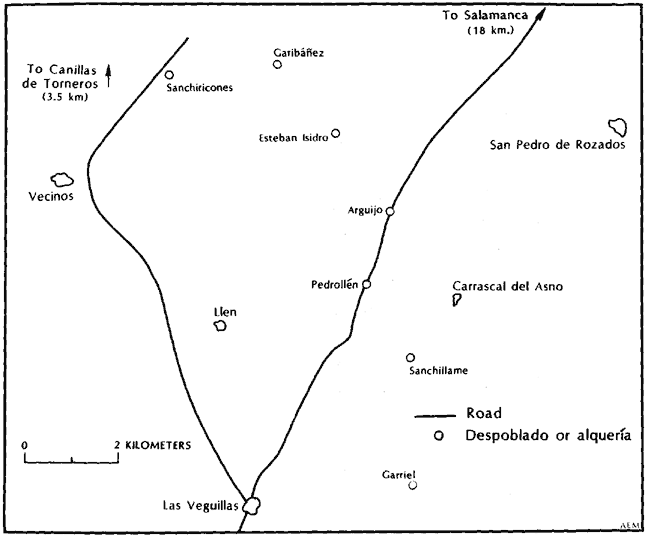
Map 9.1.—
Pedrollén and Its Environs
At the time of the catastro, Pedrollén was within the Cuarto de Peña de Rey of the partido of Salamanca. The catastro describes it as one-fourth league from east to west and three-fourths from north to south.[1] An alquería, it lacked a government of its own and came under the jurisdiction of the alcalde of San Pedro de Rozados, seven kilometers to the northeast.[2] It was what was known as a término redondo or coto redondo, that is to say, the entire unit was a single property, although in this case various individuals owned shares in it and divided the income from it.[3] Bordering on it were the despoblado of Sanchillame, the alquerías Arguijo and Garriel, and the lugar Llen (Map 9.1). In 1786 Pedrollén, Arguijo, Garriel, and Llen had only six households among
[1] AHPS, Catastro, Pedrollén, resp. gen. Q 3. The entire catastro of Pedrollén is in one volume.
[2] Pedrollén, maest. segl., f. 2r.
[3] Pedrollén, resp. gen. Q 3. According to David Vassberg, Land and Society, 169–70, the terms coto redondo and término redondo were applied in the sixteenth century to areas for which the crown had sold enclosure permits that prohibited open grazing by animals of other owners. This is probably the origin of the terms.
them, forty people. Sanchillame, a despoblado, did not have a separate census return; one guesses another family lived there.
The region had not always been so thinly populated. In 1534 Llen (then called Layn) had twenty-three vecinos, over eighty people. At that date Pedrollén and Carrascal del Asno were counted together and had sixteen vecinos, about sixty-five people; in 1786 they had populations of ten and seventeen respectively. The decline appears to have been continual since the sixteenth century. The census of 1712, which was usually underenumerated, shows seventeen vecinos for Pedrollén, Arguijo, Garriel, and Llen; at the time of the catastro there were twelve; in 1786, I estimate nine and a half (the half a widow) (Table 9.1).
The catastro records the area of Pedrollén as 1,009 fanegas, but how this compared with La Mata's 1,073 fanegas is hard to say, because Pedrollén followed an old practice of defining a fanega of land as the area sown with a fanega of grain (with the result that a fanega of good soil was smaller than a fanega of poor soil).[4] There was little further resemblance between the two places. In Pedrollén only 220 fanegas (22 percent) was used as arable, and this was divided in three fields, or hojas, each of which was sown only once in three years. One hundred forty-five fanegas was classed as pasture (prados de secano), and the rest, 64 percent, was uncultivated monte alto covered with encinas, used for the harvest of acorns and for wood to make charcoal. The average annual product of a fanega of land was five reales; in La Mata it was forty.[5] Four houses marked its center, along with two granaries (paneras), two haylofts (pajares), and three smaller buildings used for a forge and shelter for the animals.[6]
The income, or aprovechamiento, from Pedrollén was legally divided into eighteen shares (partes ), which belonged to two artistocrats and two religious foundations (Table 9.2 and Figure 9.1). The catastro does not say when or how this unusual division took place, but it went back a long time, for we know from another source that don Andrés Villalón and his wife doña María Villafaña established a patronato in the church of San Julián of Salamanca in 1501, endowing it with nine of the eighteen shares in Pedrollén.[7] The four current owners did not manage the
[4] See Pedrollén, maest. ecles., at end. On this widespread European practice, see Mendras, Vanishing Peasant, 62. Measures of land varied depending either on the time it took to plow the land or the amount of seed the land required. In Spain the amount of seed appears to have been the most common basis for measurement.
[5] Statistics on income per fanega come from analysis done for Part 3.
[6] Pedrollén, maest. segl.
[7] The record of the sale in AHPS, Contaduría, libro 850, ff. 410v–411r.
| ||||||||||||||||||||||||||||||||||||||||||||||||||||||||||||||||||||||||||||||||||||||||||||||||||

| ||||||||||||||||||||||||||||||||||||||||||

Figure 9.1.
Pedrollén, Ownership of Shares, 1752
estate themselves but rented it to a single individual (colono ), who became responsible for its administration. The catastro has no information on how the contract between them was made, whether the tenant negotiated with them individually or, what was more likely, the four employed a common agent to deal with him.
The makers of the catastro were required to specify the rent and income of tenants on ecclesiastical lands. We have seen before how their replies make possible an estimate of the total rent paid by the vecinos of a locality. I have assumed that secular landowners charged the same rent as ecclesiastical; in the case of Pedrollén this is certain since it was all leased under one contract. The makers of the catastro calculated that the tenant paid one-sixth of the grain harvests as rent, and they assigned the entire income from the meadows and monte to the owners (meadows and monte were never attributed a large annual product; in Pedrollén it ran from 2 to 6 reales per fanega). According to the extent and quality of land and the expected harvest from it, the total rent comes to about 41.5 fanegas of wheat, 11.0 fanegas of rye, and 2,700 reales per year. At prevailing local prices, these payments convert to 242 EFW.[8] As will be explained soon, the catastro may have overestimated the productivity of Pedrollén's arable by about a third, and if so, the rent is also overestimated by 17 EFW. In the absence of the lease, we can posit that the tenant paid 225 EFW, although one must be suspicious of the figure because it rests so heavily on the amount paid for pasturage, calculated on a very rough measure.
The farmer who could undertake such a contract was a man of considerable substance. His name was Francisco García Serrano, a widower forty-eight years old, whose only family living with him was a son of nineteen. Besides the furnishings of his house, his farm utensils, tools, carts, and other equipment, he owned an extensive assortment of livestock (Table 9.3). From its listing one can see that in addition to his crops, García Serrano produced for the market wool, cheese, cattle, lambs, pigs, goats, chickens, and turkeys. In fact he had so many animals that Pedrollén could not support all of them, and all except the oxen pastured elsewhere part of the year, "where there is best accommodation" ("donde mas comodidad halla").[9]
His was a diversified establishment, geared to extract all possible profit from the estate, and it required a number of hands to run. Living
[8] Pedrollén, resp. gen. Q 14: fanega of wheat, 15 reales; fanega of rye, 9 reales.
[9] Pedrollén, maest. segl., f. 2v.
| ||||||||||||||||||||||||||||||||||||||||||||||||||||||||||||||||||||
with him, García Serrano had eleven men servants, ranging in ages from twelve to thirty-eight, and three women servants. Three men were vecinos of nearby towns; they must have left their families behind to come to work in Pedrollén. Three others had the same last name as the tenant, García (Gerónimo, aged twenty-four, Lorenzo, aged eighteen, and Marta, age not given); it is a common name but perhaps they were relatives taken in partly as a family obligation. In addition there were two shepherds, one sixty and the other forty-two, both married, with four sons and five daughters between them, the youngest a baby boy of two months at the time of the count. García Serrano and the two shepherds were the three vecinos of the alquería. Altogether twenty-nine people were living in its four houses, with only the four or five youngest children not contributing labor to its economy.[10]
As for La Mata and Villaverde, the catastro provides sufficient information to formulate an approximation of the income of this small group, both collectively and individually. Multiplying the number of fanegas of each class of arable land by the stated annual harvest, one obtains a total annual harvest of 248 fanegas of wheat and 66 of rye, that is, 288
[10] Pedrollén, libro personal de legos.
| ||||||||||||||||||||||||||||||||||||||||||||||||||||||||||||||||||||||||||||||||||||||||
| ||||||||||||||||||||||||||||||||||||||||||||||||||||||
EFW (Table 9.4). More of the harvest here was in rye than in La Armuña, because it was needed to supplement pastures for the large number of livestock.[11] One can expect a more reliable figure, however, from the record of the tithes for the previous five years (1747–51), which indicates a mean harvest of 215 EFW (Table 9.5). This is only 75 percent
[11] See García Fernández, "Champs ouverts," 694.
of what the catastro evaluated that the land produced. There is, of course, the possibility that the tenant of Pedrollén succeeded in hiding some of his crops from the tithe collector, perhaps not very difficult since the latter had to come from the town of Canillas de Torneros, twelve kilometers away, to whose parish Pedrollén was attached. I shall proceed, however, on the assumption that the tithes were an honest tenth of the crops.
Since a fanega of arable was the area sown by a fanega of grain and there was a three-year rotation, the annual seed requirement must have been one-third of the total area of each kind of arable land (Table 9.4), 57 fanegas of wheat and 16.5 of rye (a total of 67 EFW). The yield-seed ratio varied from 3.5 to 6 for wheat (overall 4.4) and 3.5 to 4.5 for rye (overall 4.0). These are low returns, emphasizing the marginal quality of the soil in this region.
The vecinos also paid tithes on their animal products, partly in kind and partly in money, so that one can again estimate their income from this source (Table 9.6). Lambs, wool, and cheese were said to be contributed at the rate of one in ten. It is less easy to know how many other animals were produced because the tithes on them were paid in money. On cattle, horses, mules, and donkeys, the rate was eight maravedís per head (thirty-four maravedís is one real). The average annual payment over five years was thirty-four reales and nine maravedís, equivalent to 146 animals. Since there were only 136 of these kinds of animals in the estate, the figure is too high. On the other hand, a mean of 16.4 lambs per year in tithes (only 10 for the latest year reported, 1751) did not
| ||||||||||||||||||||||||||||||||
| ||||||||||||||||||||||||||||||||||||||||||||
cover all the lambs born, for García Serrano and the shepherd Juan Benito between them had 332 lambs under one year at the end of 1752.[12] They must have paid some of the tithes on lambs in coin, and the tithes in coin may also have included payments for goats, chickens, and other minor animals. We can estimate the annual income from the larger animals (including sheep and goats) by using the method in Appendix K (Table 9.7). This method covers cheese and wool as well, so that Table 9.6 will not figure in the calculation of the gross and net income of Pedrollén. The method does not cover fowl. Chickens were worth twenty-four maravedís, and turkeys, two reales. Let us guess another seventy-five reales from them.
The total income from livestock comes to 596 EFW. From farming the gross harvest is 215 EFW. If the rent was 225 EFW, as estimated, it represented 28 percent of the product of the exploitation. The share taken by the rent was really higher, however, for part of the livestock was pastured elsewhere.
The other regular charges and expenses of the establishment must be deducted to obtain the net income. The tenant and one shepherd paid for pastures part of the year outside the alquería. No figure is specified, we can only guess 500 reales of 33 EFW. The tithes and other charges all left the community, since it had no church. Four-ninths went to the par-
[12] Pedrollén, maest. segl.
ish of Canillas de Torneros, three-ninths to the owner of the prestamo (a convent in Segovia), and two-ninths (the tercias reales) to the University of Salamanca. The first fruits were 2 EFW, and the Voto de Santiago, 1 EFW.[13] The catastro specifies only one payment to the crown, the servicio ordinario y su quince al millar, 9 reales and 3 maravedís. It says the place also paid rentas provinciales and millones, but does not state the amounts.[14] However, from a summary of the royal taxes of the province in 1795, we learn that the "old encabezamiento" of Pedrollén, presumably the one in effect in 1752, still valid in 1795, was 147 reales and 24 maravedís for alcabalas, 118 reales and 6 maravedís for cientos, and 29 reales and 2 maravedís for millones, a total of 19.7 EFW.[15]
Striking a balance of expenses against gross income produces a net income for the estate of 424 EFW (Table 9.8). Divided among the twenty-nine people living on the estate, this gives a per capita income of 14.6 EFW. Yet a close look at the resources of the community uncovers an additional source of income. García Serrano owned fifteen yokes of oxen and employed eleven hired hands. With his son and himself, he could keep thirteen plow teams at work. They planted only about seventy-five fanegas of land a year in Pedrollén, roughly enough to use the time of three and a half plow teams and drivers.[16] The time of the other workers and yokes must have been applied outside in the neighboring alquerías and despoblados. Within Pedrollén three and a half yokes would each account for a net harvest of 25 EFW, after deduction is made for seed, rent (one-sixth of the grain harvest), tithes, and other charges. If each yoke returned the same net harvest outside, then García Serrano received about another 240 EFW from this source, raising the net product to 664 EFW and the per capita income to 22.9 EFW (Table 9.8).
This is the highest per capita return that we have encountered so far, but it should not mislead us into thinking that all the inhabitants were wealthy. Virtually all the gross income went initially to García Serrano, except for what the shepherd Juan Benito obtained from his animals. According to Appendix K a fair estimate is that Benito's eighty female sheep and fifteen female goats produced 43 EFW, but probably 5 EFW went for rent on pastures and tithes. Out of the balance left to him, García Serrano would have to pay wages and keep for his servants. The
[13] Pedrollén, resp. gen. Q 15.
[14] Ibid. Q 27.
[15] AGS, Dirección General de Rentas, Hacienda, legajo 2664, Salamanca (1795), Relación de los Pueblos.
[16] See Chapter 7, n. 30.
| ||||||||||||||||||||||||||||||||||||||||||||||||||||||||||||
catastro says that he, his son, servants, and one jornalero earned 2.5 reales a day but does not say for how many days a year. In La Mata the figure was 120 days per year, in Villaverde 180. The latter figure, more suitable to a place with multiple activities, gives them an annual income of 30 EFW. The three vecinos of nearby towns would have had to take this much back to their families to make their stay worthwhile. The eight male servants (four were under eighteen) and three female servants probably earned little more than their keep, the adult males perhaps 12
| ||||||||||||||||||||||||||||
EFW, the others 10 EFW.[17] The two other vecinos of Pedrollén, both shepherds (also called jornaleros, the catastro erred in speaking of only one jornalero in specifying incomes) had families. Benito had a wife, a son of twelve, and three daughters; Manuel Martín a wife, three sons (aged fourteen years, ten years, and three months) and two daughters. If they had incomes of 12 EFW per capita, Benito would have taken an additional 32 EFW from the net income of Pedrollén and Martín 72 EFW (not counting the baby). Wages and subsistence of the twenty-nine persons in the community then come out as in Table 9.9, a total of 330 EFW. The balance remaining to García Serrano would be 300 EFW. There are many unknowns in calculating both his gross income and his expenses, so that this is a very rough figure, but one can say that his economic status resembled that of the top labradores of La Mata, whose net income was between 230 and 350 EFW, possibly equal to that of Juan Rincón, the richest of them all. In Pedrollén, however, he stood alone above his servants and employees as a man of wealth and power. With only one son, he could well save, probably investing in extending his establishment, if land were available in the vicinity for arable and pastures.
[17] These are the wages I have used in La Mata and Villaverde (Tables 7.13 and 8.18).
Yet his position as tenant of a coto redondo left him vulnerable to the demands of the owners. The dangers he faced are evident in cases that came to the attention of the Council of Castile. In the decade of the 1760s, when the advisers of Carlos III undertook to reform the conditions of landholding, they had before them, among complaints from various parts of the country, two from tenants of the cotos redondos of the Charro district. The tenant of Sanchiricones, about ten kilometers northwest of Pedrollén, protested that the cathedral chapter of Salamanca, owner of six of eight shares in the place, had raised his annual lease from 6,406 to 16,112 reales in 1763. Similarly the tenant of Terrones, about the same distance from Pedrollén to the southwest, reported in the same year that the cathedral chapter, full owner of this coto redondo, was demanding 20,000 reales rent, whereas at present it was 12,500 and only six or eight years previously it had been 9,400. The tenants affirmed that they could not pay such rents and, if dispossessed, would be ruined for lack of pasture to support their livestock. Nevertheless, the cathedral chapter was relentless and threatened to move its own herds into the places. At the petition of the two tenants and the sexmeros procuradores generales (deputies) of the cuartos (or sexmos ) of the partido of Salamanca, who defended the interests of the vecinos, the Council of Castile stepped in to protect the tenants, forcing arbitration in the first case and encouraging a settlement out of court in the other but in neither case stating that the rent should be held at its current level.[18] The experience of these two tenants shows that such men, including García Serrano of Pedrollén, were under pressure to pay to the limit of their abilities. Their potential for saving was under the keen observation of the owners of the alquerías or their agents, who were intent on squeezing as much as they could out of their colonos. Whether García Serrano was able to maintain the income of 1752 is thus open to question. If he and his successors could continue on similar terms, they should have been in a good position to respond to the disentail of Carlos IV, perhaps not to buy a share in Pedrollén but at least to invest in land elsewhere.
2
Something happened to the establishment, however, about which I have no information. Thirty years later, at the time of the census of 1786,
[18] Mem. ajust. (1784), expedientes 2 and 4, §35–50 and §57–59. Expediente 2 is reprinted in Revista de trabajo 17 (1967): 148–53.
only ten persons remained in Pedrollén. There was a girl under seven, two boys and two girls between seven and fifteen, and five adults, all between twenty-five and thirty-nine. The adults consisted of a married couple, two single males, and a widow. We do not know their names or the relationship among them. García Serrano would have died, but his son would now be fifty-three. The census lists no such person. Perhaps he and other residents of Pedrollén had succumbed to an epidemic of malaria that struck much of central Spain including this region in 1785 and 1786.[19] If so, the widow may have been his, raising several of their children and keeping the establishment going with the aid of a married couple. The rest would have been shepherds and servants. Still, three adult men would have had difficulty maintaining the entire establishment that had existed in 1752. They must have given up leases to neighboring places. One senses that the estate had been through a crisis and a new start was being made, but control over its fate lay elsewhere, with the owners or their agent.
When the intendant of Salamanca received the royal orders calling for disentail of ecclesiastical properties, Pedrollén was just the kind of place that would first attract his attention. Its shares belonging to religious institutions fell under the terms of the decree of September 1798; they could be readily transferred by a simple deed; and they would command a high price. He put them up for auction in 1799, and the final deeds were both signed in November of that year. The same person bought both, doña María del Rosario Vélez y España, widow of a regidor of the ayuntamiento (city councillor) of Salamanca.
The 1 3/4 shares belonging to the benefice of the parish of San Martín fetched 26,320 reales. The 9 shares (half the entire property) of the patronato founded by don Andrés Villalón and his wife in 1501 in the parish church of San Julián cost her 135,350 reales. She paid for both with vales reales.[20] The rent for Pedrollén in 1752 was 225 EFW, and if it had kept pace with the rise in price of wheat, doña María del Rosario's 10 3/4 shares would give her 5,375 reales (at the current wheat price of about 40 reales). She was expecting a return of 3.3 percent on her capital, but since she paid in vales reales, which at the end of 1799 were worth only about one-third their face value in hard currency,[21] her real expected re-
[19] Pérez Moreda, Crisis de mortalidad, 336–44. Pérez Moreda cites a contemporary document listing 7,606 ill and 271 dead in Salamanca province in 1786.
[20] First sale: AHPS, Contaduría, libro 850, f. 410r–v; second sale, f. 410v–411v. They are recorded in Madrid, AHPM, A2965 and A3063, where it is stated that payment was in vales reales.
[21] See Appendix D.
turn was about 10 percent. This is a far higher rate of return than the annual 2.5 percent on arable fields that buyers were prepared to get[22] and provides evidence that large properties went relatively cheaply.
Within a year of the royal order, 60-percent interest in Pedrollén had changed hands. Whereas laymen held 40 percent of it before, they now held 100 percent. Since the new owner resided in Salamanca city, the city did not lose any interest in the alquería, but the transfer represented a serious blow to its religious institutions. Furthermore 60 percent of it was now in the hands of one person; previously the largest share had been 50 percent. And this 60 percent was not entailed, as all the shares had previously been. A major step had been taken in the process that made the Pedrollén of today the property of a single individual.
In this process the tenant never had a chance of participating. The smaller share was sold for about 660 EFW, the larger for 3,400 EFW. Even the smaller share cost one and a half times the net annual production of the estate. García Serrano might have achieved savings to acquire the smaller share, but only because he owned the means to farm in more than one alquería. The current tenant probably had no such economic potential. He could only watch his landlords change and hope that the new one would be no more exacting than the old. A quarter of a century later, in 1826, the population of Pedrollén was twelve, with three vecinos (Table 9.1). There were only two more people than in 1786, and their future was no brighter than it had been then. Disentail did not reverse the demographic decline that began in the sixteenth century or improve the condition of the men and women who worked the land and tended the livestock.
[22] See above, Chapter 5, section 3.
Chapter X—
El Mirón
Today the southern border of the province of Salamanca is formed by the Sierra de Candelario and the Sierra de Gata, which are western extremities of the mountain range that cuts across central Spain and separates Old Castile and León from New Castile and Extremadura. In the eighteenth century the southern part of the province extended farther east than it does today to include two valleys lying in the shadow of the more imposing Sierra de Gredos, which boasts the highest mountains in central Spain. One of these runs along the northern flank of the range and contains the headwaters of the Rio Tormes, flowing here from east to west before turning north at Barco de Ávila eventually to pass the city of Salamanca and join the Rio Duero at the Portuguese frontier. The other is the broader and gentler valley of the Rio Corneja, separated from the valley of the Tormes by the low Sierra de Villafranca. In the nineteenth-century reorganization of provinces both of these valleys were transferred to the province of Ávila.
The dominant town of the valley of the Corneja is Piedrahita. The cabeza of the partido that contains most of the fertile valley, it has long been a center of some prominence. In the early sixteenth century it gained notoriety as the home of a mystic nun of the suspect sect of Alumbrados, the Beata de Piedrahita.[1] In the eighteenth century the Duques de Alba, who were señores of both these valleys together with much of the rest of the southeast of the province, built an austere granite
[1] Bataillon, Erasme et l'Espagne, 73–74.
palace just above the town. Local tradition, hardly reliable, holds that Goya painted the Maja Désnuda in one of its rooms.
Piedrahita lies at the foot of the Sierra de Villafranca, and from its vantage point one can see the valley of the Corneja stretching out to the north, almost circular and surrounded by hills in all directions. Straight across the valley, about twelve kilometers away, a rocky outcropping juts up sharply from the valley floor. At its western end is an impressive rounded peak of barren rock. Still today it is surmounted by the ruins of an ancient fortification known simply as the castillo. Just behind and beneath the castillo lies a town known as El Mirón, "the lookout," whose name testifies to its strategic value. The site is so distinctive that legends surround it—one is that an old escape tunnel runs all the way from the garden of the palace of the Albas in Piedrahita under the valley to come out at the castillo. In the Civil War, fires were lit beside this fortification to guide Nationalist airplanes returning to Salamanca from bombing Madrid.
The town of El Mirón is built against the northern shoulder of this rock, out of sight of the Corneja valley. Its fields fall away gradually to the northwest, north, and northeast, on a harsh plateau. In the eighteenth century, El Mirón was legally a villa and cabeza de partido. Five towns (lugares) were under its jurisdiction; together they constituted the smallest partido of the province. (Piedrahita had twenty-three towns under it.)[2] The mountainous southern part of the province was characterized by larger towns than the plains around Salamanca, but four of the towns of the partido of El Mirón were small by any standard. Valdemolinos, Navahermosa, El Collado, and Villar de Corneja had populations of 46, 71, 116, and 124 respectively in 1786. Three of them bordered on El Mirón and were closely tied to it: Valdemolinos, in a rocky valley to the west, El Collado on a pass in the hills to the east, and Navahermosa on the edge of the broad valley beneath the rock (Map 10.1). El Collado and Navahermosa were anexos of El Mirón and paid tithes to its parish.[3] Villar de Corneja lies off to the southwest, outside the immediate orbit of El Mirón. The fifth lugar, however, was a different case. Santa Maria del Berrocal, located on the northern edge of the valley, below the rocky hill of El Mirón, had a population of 517, two-thirds again as large as El Mirón's 311, making it the demographic center of gravity of the partido. Finally, in constructing a picture of this eco-
[2] España dividida en provincias ," 453–54.
[3] See AHPA, Catastro, El Mirón, libro 548 f. 14.
Map 10.1.
The Partido of El Mirón and Nearby Towns
NOTE : Since the eighteenth century El Mirón has
incorporated Aldeaelabad, and Santa Maria del Berrocal
has incorporated Navahermosa and Valdemolinos.
nomic region, one must also take into account Gallegos de So el Mirón (Gallegos under El Mirón, today Gallegos de Solmirón). By road it is the closest town to El Mirón, lying below it a few kilometers to the northwest and visible from the castillo. In the eighteenth century it was a villa eximida, which meant that it lay outside the jurisdiction of any partido, and in 1786 it had 682 inhabitants, more than twice the population of El Mirón.
El Mirón was the most isolated of all the places in the partido. Two
roads lead north from Piedrahita to Salamanca. One runs west of the rock of El Mirón, through Santa María del Berrocal, Valdemolinos, and Gallegos de Solmirón, and its traffic helps explain the greater size of the first and last of these. The other runs east of El Mirón, crossing the rocky outcropping at El Collado. El Mirón itself can be reached only by spurs off these roads and requires a person coming from Piedrahita to make a wide circle around its rock. It owed its prominence to its selection, centuries earlier, to be the legal head of this tiny partido, very likely because of its castle and strong defensive position.[4]
The available evidence indicates that since the sixteenth century El Mirón, despite its administrative primacy, had been losing out economically to Santa María del Berrocal, beneath it in the valley. The census of 1534 shows a total of 131 vecinos for El Mirón and its two anexos and 63 vecinos for Santa María.[5] But by 1752 El Mirón and its anexos had declined to 106 vecinos, while Santa María had risen to 90. In the next thirty-five years El Mirón's relative decline continued, both with respect to Santa María and to the partido as a whole. In 1752 it had 32 percent of the vecinos in the partido; in 1786 it had 26 percent of the total population. Conversely Santa María rose from 39 percent of the vecinos in 1752 to 44 percent of the total population in 1786 (Table 10.1). Although the census figures are not fully reliable, the trend is so clear that it can hardly be the effect of census errors.
The structure of the partido fostered a struggle between El Mirón and Santa María del Berrocal. El Mirón, high on its rocky hill with its harsh plateau and numerous flocks, clung to its privileged position as cabeza de partido. Santa María, blessed by land in the valley and a highway, found its strength in farming and transit. One can almost imagine the forces pitted against each other as a microcosm of the tensions in Spain as a whole: the eighteenth-century economic conflict between a politically dominant meseta and a fertile trading periphery.
In 1752, at the time of its catastro, the nucleus of El Mirón consisted of 81 houses, of which 6 were empty and another in ruins; there was no population pressure on this resource.[6] It was thus larger than La Mata (62 houses) but smaller than Villaverde (116 houses). Its public buildings included the town hall (casas consistoriales ), a smithy ( fragua ), a
[4] In 1534 it was already a cabeza de partido; see the census of that date in Tomás González, Censo . . . siglo XVI, Appendix 5.
[5] Ibid.
[6] El Mirón, maest. segl. and maest. ecles., show eighty houses and one in ruins. Resp. gen. Q 22 says seventy-two houses, of which six are empty and one in ruins. I accept the first as accurate for the number of houses, the second on the number empty.
| ||||||||||||||||||||||||||||||||||||||||||||||||||||||||||||||||||||||||||||||||||||||||||||||||||||||||||||||||||||||||||||||||||||||||||||||||||||||||||||||||||||||||
| ||||||||||||||||||||||||||||||||||||||||||||||||||||||||||||||||||||||||||||||||||||||||||||||||||||||||||||||||||
Figure 10.1.
El Mirón, Employment Structure, 1752
butcher shop (carnicería ), a granary (alfondiga, that is, the town pósito),[7] and an early sixteenth-century church with a square stone tower and late medieval arches over the altar but only a wooden roof over the nave. Even in the eighteenth-century El Mirón had a very modest appearance, much more like an ordinary lugar than a villa and cabeza de partido.
The catastro records sixty-seven lay families and two priests, each with his household. Table 10.2 and Figure 10.1 give the occupational distribution. Although El Mirón had nine artisans, all associated with the making and tailoring of cloth, it was more completely an agricultural community than either La Mata or Villaverde. Farming and pasturage occupied almost three-quarters of the male heads of household.
Its land was its major source of income, stretching out on the rolling plateau beyond the rocky ridge on which the town is located. The catastro indicates that it had an area of 2,841 fanegas outside the town nucleus.[8] One cannot, however, compare this figure with the 1,073 fanegas of La Mata or 1,650 fanegas of Villaverde, because the fanega of El Mirón, or fanegada as they preferred to call it, was not a fixed area. In
[7] El Mirón, resp. gen. Q 23.
[8] Total of tables at the beginning of the El Mirón, maest. segl. and maest. ecles.
the custom of this region, as in Pedrollén, a fanega or fanegada was the area of arable that took a fanega of seed, a fanegada of good land being smaller than one of poor land. The informants did not say how much these might measure in area. The fanegada of woodland (monte) was defined as an area that contained fifty live oak trees (pies de encina ), again not a fixed measurement. A unit of pasture was called a peonada and described simply as equivalent to a fanegada.[9] Despite these uncertainties, it becomes clear that the término of El Mirón was far greater than that of either La Mata or Villaverde.
On the other hand, the information provided by the makers of the catastro reveals a mediocre soil. Almost a third, 931 fanegadas, was pasture and wooded hills of live oak, to which no value could be assigned "because of its bad quality and location and also because the oaks are usually eaten by worms so that in most years they do not bear acorns, and when they do the crop is so small that it does not provide enough fodder for the few animals of the vecinos, nor do they provide more wood than is needed for their houses and farm implements."[10] The vecinos did not intend to hide their hardships from the king. Of the remaining 1,910 fanegadas, only 18 percent was good enough to plant wheat. Sixty percent produced rye. The plowed land consisted of small plots distributed through three great fields (hojas), each sown only once every three years. A small number of fields enclosed by stone walls (cortinas), totaling 4 percent, produced rye for green forage (herren) every year; the rest was meadows from which hay was cut: 12 percent produced hay every year, 7 percent only once every three years. The average annual income from a fanegada of productive land in El Mirón averages out to be twelve reales, far below La Mata's forty reales or Villaverde's thirty-six reales per fanega.
Following the method with which we are now familiar, from the stated amount of each quality of land and the predicted harvest on it, one can obtain a predicted total annual harvest of 457 fanegas of wheat and 1,180 fanegas of rye, at fifteen reales per fanega of wheat and ten reales for rye,[11] 1,244 EFW. According to the makers of the catastro the yield-seed ratios for both kinds of grain were 5 : 1 on first-quality land, 4 : 1 on second, and 2 : 1 on third; overall 4.0 : 1 for wheat and 3.1 : 1 for rye. These ratios are so low as to be suspicious.
[9] El Mirón, resp. gen. Q 9. The Real Academia Española, Diccionario de la lengua española (17th ed., Madrid, 1947), defines the peonada as 380 square meters, about 6 percent of a fanega, but this definition clearly does not apply here.
[10] El Mirón, maest. segl., "Propios," ff. 4–15.
[11] El Mirón, resp. gen. Q 14.
When one attempts to compare the predicted harvest with the tithes, one runs into difficulties. The parish collected the tithes of El Mirón along with those of its two anexos, and the catastro reports only the total figures for all three. One can, of course, calculate the predicted harvests of the anexos from their catastros and determine El Mirón's share of the total of all three. For Navahermosa the prediction is 444 EFW, for El Collado 250 EFW.[12] According to these predictions, El Mirón's harvest represented 64 percent of the total of all three. A more reliable source is the tithe register of the parish of El Mirón, available for 1788–1815 in the town church archives.[13] For the six-year period 1796–1801, the mean annual share produced by El Mirón of the total partible tithes of these three towns was 53.1 percent. In these two three-year cycles, the harvest of El Mirón and the corresponding percentage was lower in the middle year. If the cycles had been repeated regularly since midcentury, in the five-year period 1747–51 for which the catastro gives the average tithes, the hoja of El Mirón with the low return would have been farmed only once, and El Mirón's share of the partible would have been about 54.2 percent. I trust this figure more than the 64 percent derived above from the evaluation of the land in the three towns.[14]
A second difficulty arises in predicting the harvest from the reported tithes because the catastro gives two sets of figures for the tithes. One appears to be a preliminary working sheet, the other is the information reported in the respuestas generales. When the reports are converted to EFW, the total of the first is 2.05 times the second. One might suspect that the larger quantities are correct, the smaller ones doctored to avoid reporting the town's full wealth. When one compares the two returns with the predicted harvests, however, one discovers that the working sheet indicates harvests far in excess of what the land could produce, whereas the smaller return, adjusted to cover lands exempt from tithes, matches the predicted harvest from the three towns within 1.5 percent. Such astounding accuracy impresses one with the capacities of the makers of the catastro and gives confidence in the reliability of the predicted harvest. It gives such confidence, that is, until on using it to calculate the
[12] AHPA, Catastro, Navahermosa; ibid., El Collado.
[13] Archivo Parroquial, El Mirón. I am indebted to don Antonio Hernández Sánchez of Gallegos de Solmirón, former curate of El Mirón, and don Juan Victor García Gómez, its alcalde and schoolmaster, for locating this book. While I performed the tedious task of copying this document in 1964 and 1969, don Juan and his wife made me welcome for many hours in their home, keeping alive a brasero under the skirt of a round mesa camilla to warm my legs, a pleasure of the centuries since destroyed by butagas stoves.
[14] In 1797 and 1800 El Mirón's share of the tithes of its parish was 50.1 percent and 46.1 percent respectively.
| ||||||||||||||||||||||||||||||||||||||||||||||||||||||||
| ||||||||||||||||||||||||||||||||||||||||||||||||||||||||||||
town income one obtains a net total from both farming and animal husbandry of under 1,000 EFW, about 3 EFW per capita, far below any rational subsistence level!
Only the larger figures in the working sheet could reflect a viable economy. Further inspection reveals that the makers of the catastro indeed consciously falsified the tithes reported in the respuestas generales, for they left the original figures elsewhere to betray them. The tithes once collected were divided among various authorities, 2-ninths to the señor, 1.5-ninths to the bishop of Ávila, and so forth. In the libros maestros, these shares are included among the property of these individuals, and they turn out to be the proper fraction of the larger figures. If one attempts to reconstruct the reasoning that led the town authorities to falsify the tithe figures, the obvious answer—that they hoped to defraud the state—may not be the correct one. It is at least as possible that after they had totaled the measures of arable land and the harvest each measure produced, a simple multiplication led them to discover that their information could not account for the size of the harvest revealed in the tithes. Rather than revising upward the harvest on a measure of land (which would have entailed a revision of the estimated income of each individual), they simply reduced the amount they reported for their tithes. Unexplained except by oversight is the fact that they left the preliminary work sheet in the bound volume. Be that as it may, for the first time we have proof of conscious misstatement, if not cheating, in the catastro. Nothing in the provincial summaries of the catastro in the archives of Simancas and Madrid would reveal the error, only a detailed analysis of the town volumes.
The preliminary working sheet on tithes is thus the best available evidence for the harvests of El Mirón and its anexos. Table 10.3 indicates that they convert to 337.9 EFW, and if, as calculated above, 54.2 percent of these tithes represent the payments from El Mirón, its annual gross harvest covered by the partible tithes was about 1,831 EFW. To get the entire harvest, one must add the harvest on lands exempt from tithes (payments called locally diezmos privativos) and also the one on the adjoining despoblado of Naharra. The latter had been taken over by the vecinos of El Mirón, who farmed it once every three years as part of one of the hojas. Table 10.3 calculates the payments on these lands from the available information, and one can conclude that they cover a harvest of about 356 EFW, giving a total for the town of 2,187 EFW.
We may return now to the yield-seed ratio. One recalls that the fanegada was defined as the area that required a fanega of grain for sowing.
Since the townspeople reported 345 fanegadas of wheat land and 1,138 of rye land, each piece sown once every three years, their mean annual requirement should have been 368 EFW. On the basis of the reported area of arable land, we calculated an annual harvest of 1,244 EFW. The more reliable estimate obtained from the tithes, however, is 2,187 EFW, 1.76 times as great. Does that mean that the seed requirement should also be multiplied by 1.76, or that the yield-seed ratios that the information in the catastro indicates are lower than the reality, as one suspected? A requirement of 368 EFW set against the better harvest estimate of 2,187 EFW gives an overall yield-seed ratio of 5.9 : 1. La Mata had 7.2 : 1 for wheat and 9.1 : 1 for rye, Villaverde 5.2 : 1 for wheat. El Mirón had poorer land, but it was sown every third year instead of every second and most of it was rye, so that a corrected ratio of 5.9 : 1 is reasonable. It gives a net harvest after seed of 1,819 EFW.
2
Although the vecinos of El Mirón had poor land, they owned a much greater share of it than did those of La Mata and Villaverde. Table 10.4 and Figure 10.2 show that local secular ownership accounted for over half the land, with 35 percent in the hands of vecinos. Since local ecclesiastical ownership was 28 percent, only 21 percent was in the hands of outside owners, a far cry from the 72 percent of La Mata and 69 percent of Villaverde.
In response to the question on the amount of rent paid for ecclesiastical lands, the vecinos said it was one fanega of grain for each fanegada of first-class land, three-fourths fanega for second-class land, and one-half fanega for third-class land, whether wheat or rye, in the year the land was sown.[15] Unfortunately, I have no records of the rents actually charged for specific pieces of property, such as those of the monasteries in Salamanca that permitted a check on the rents reported for La Mata and Villaverde. One can, however, work out how much rent would have been paid and what percentage it represented of the total harvest, both as predicted by the catastro measurements and as corrected according to the tithe returns (Table 10.5). If the vecinos paid the rent indicated in the catastro, it would be only about 10 percent of the corrected harvest, far below the 23 percent paid in La Mata and 31 percent in Villaverde. On the other hand, the stated rate of rent would be
[15] El Mirón, maest. ecles., ff. 322–27.
| |||||||||||||||||||||||||||||||||||||||||||||||||||||||||||||||||||||||||||||||||||||||||||||||
about 20 percent of the uncorrected predicted harvest, a credible figure. It seems likely that the makers of the catastro indicated rents that would be a reasonable share of the harvests they reported. I shall assume that the vecinos paid about one-fifth of their actual gross harvests, for which the best estimate is the corrected figure in Table 10.5. This would mean that 121 EFW left the town economy as rent (20 of this to nearby churches; rent on the land of nearby vecinos will be treated next), and another 107 EFW went to the funds of the parish church.
One must also take into account the harvests on the lands owned by vecinos in nearby towns. The example of Villaverde shows that local men who owned land in a neighboring town sometimes farmed it themselves and sometimes rented it to vecinos of the town in which it was located. The opportunity costs probably determined their decision. We
Figure 10.2.
El Mirón, Ownership of Land, 1752
know how much land nearby vecinos owned in El Mirón, but to obtain a full picture, one would need the catastros of the surrounding towns to determine the holdings of El Mirón's vecinos in them. Unfortunately not all the catastros have survived. A review of the three others that are extant from the partido gives the picture of ownership across town borders shown in Table 10.6. Vecinos of towns in the valley owned very
| ||||||||||||||||||||||||||||||||||||||||||||||||||||||||||||||||||||||||||||||||||||||||||||||||||
| ||||||||||||||||||||||||||||||||||||||||||||||||||||||
little property in El Mirón, and vice versa. They probably found it economically uninteresting to travel the required distance to farm what they did have. Vecinos of neighboring towns on the plateau, however, did own a number of fields in El Mirón. Whether the converse is true, I cannot say. The only such town whose catastro has been saved is El Collado, whose vecinos owned more property in El Mirón than all other nearby vecinos together. Vecinos of El Mirón owned virtually no land in El Collado. If the imbalance were the same for the other términos of the plateau, the vecinos of El Mirón would have owned property in them producing harvests of only about 5 EFW. If, however, the balance were equal across these town lines, the outside harvests would rise to 97 EFW. Our estimate for outside harvests will be 51 ± 46 EFW.
Unable to obtain a firm figure, one can propose reasonable upper and lower bounds to the income of El Mirón from these sources. If all the
properties owned by nearby vecinos were farmed by their owners, then the owners would have taken 420 EFW from the total town harvest.[16] The parish of El Mirón would receive half the tithes on these harvests.[17] Not counting those of vecinos of its anexos, El Collado and Navahermosa, whose tithes it received anyway, these would amount to 10 EFW. If all the lands in question had been rented to farmers of El Mirón, the harvest would stay in the town, except for the amount paid in rent, 20 percent or 84 EFW. To judge from the pattern at the end of the century revealed in the tithe register, which shows about fifty outside farmers per year paying tithes to the parish, the real situation was probably closer to the first than the second scenario.
Income from lands that the vecinos owned in neighboring towns is even less clear, but the amounts involved are small. If they rented out all their lands, their rent would be 10 ± 9 EFW. If they farmed it all themselves, their harvest (less tithes and seed) would come to them. Now, other factors being equal, one would expect farmers in different towns to follow similar practices in the matter of farming or renting out their outside lands, so that what each town economy lost in harvests to nearby vecinos, it gained in harvests from outside. Table 10.8 calculates the income to the vecinos under these two limiting patterns.
If it is difficult to approximate with accuracy the income of El Mirón from farming, one enters even more insecure terrain in calculating how much the vecinos received from raising livestock. This was one of the few sources of income that the catastro did not seek to estimate. The value of real property was given in terms of the income it produced; and wages, salaries, and commercial income were reported, as was income from tithes and seigneurial dues. But chattel were simply enumerated, along with their value per head. No information was provided on how many animals were born and sold each year, how much cheese, milk, or wool was produced or sold, how many animals were slaughtered. One is forced to rely on what the tithe returns say and on what can be deduced from the head count of animals. For towns such as La Mata and Villaverde, a relatively small part of whose income came from livestock, the issue is secondary; but in Pedrollén our assessment of the profitability of the enterprise depended heavily on the estimate of income from
[16] Counting the harvests at 2.05 times the catastro predictions, to make the correction noted earlier.
[17] There is no statement on the rate for tithing outsiders, but the practice of La Armuña probably held here also. The tithe register of El Mirón shows that outsiders did pay tithes to the parish on their harvests in the parish limits.
| ||||||||||||||||||||||||||||||||||||||||||||||||||||||||||||||||||||||
animals. In El Mirón also animal husbandry was of major importance, and uncertainty about income from this source weakens the assessment of town income.
Appendix K describes the method I have settled on to estimate income from animals. There is the additional difficulty that here, as in the harvests, the vecinos understated their wealth. The authorities who compiled the provincial summary appear to have uncovered their deceit, for the provincial summary attributes El Mirón more animals than the town catastro. Table 10.7 uses the numbers in the summary to calculate the town income from livestock, 1,771 EFW.
It is proper to note that the information provided by the reported tithes (in the working sheet, not the reduced figures in the respuestas generales), does not indicate such large reproduction for sheep and goats, as Appendix K, Table K.2 establishes. It says the parishioners paid ninety-nine lambs and nine kids per year, at the rate of one for every ten born. Since the farmers of El Mirón owned about one-half of the sheep and four-fifths of the goats in the parish, this would mean they had about five hundred lambs and eighty kids born per year; whereas
the ratios adopted in Appendix K result in about fifteen hundred lambs and five hundred kids per year. If the reported tithes were an honest reflection of the animal births, the birth rate was far lower than the estimate in Appendix K and the resulting income lower than in Table 10.7. The estimated income, of course, includes the production of wool and cheese, and the tithes report on this, too. For the entire parish they were 711 pounds of wool and 55 pounds of goat cheese. With wool valued at 1.0 real per pound and cheese at 0.6 real per pound, the share of El Mirón represented a gross production from these two sources of about 3,800 reales, or 255 EFW. The number of births indicated by the tithes multiplied by the stated value of lambs and kids (5 reales each) results in an income of about 210 EFW, for a total income of 465 EFW from these two breeds, barely 40 percent of the estimate in Table 10.7. This result seems unreasonably low, but the contrast between it and my figure means that one cannot dispel the uncertainty about the income from animals. The queston must remain open.
Most if not all the pastures must have been within the town limits, but the owners of livestock had to pay rent on meadows and cortinas belonging to the parish and outsiders. If the rent were the annual income attributed by the catastro to these properties, the vecinos paid for them 108 and 131 EFW respectively.
One can now tabulate the income from agriculture of the farmers. Table 10.8 provides two figures for net income from agriculture, which represent the maximum and minimum estimates from harvests and animals. The larger estimate, 2,710 EFW, is almost 50 percent greater than the minimum figure, 1,836 EFW, yet the two estimates do provide limits within which we can proceed.
Because so much income came from livestock (44 percent of the minimum estimate; 55 percent of the maximum estimate), the methods used previously to determine the distribution of this income among the labradores and others engaged in farming are of limited value. Nevertheless the available information must be milked for all that it can produce. The catastro states that twenty-seven "labradores and senareros" had large enough harvests to pay first fruits, one less than the number of men identified as labradores in the list of vecinos.[18] (Here a farmer had to pay first fruits if he harvested ten fanegas of any single grain; in La Armuña the amount was six fanegas.) In the three years 1799–1801,
[18] El Mirón, resp. gen. Q 16.
covered by the tithe register, an average of forty-four farmers harvested enough to pay first fruits. (Three years are needed because of the local three-year rotation.) Table 10.9 shows the distribution of the gross and net harvests among them, and it projects this distribution onto the twenty-seven harvesters in 1752.
The striking feature of the table is the low income of the labradores. At the end of the century, the first tither had a net income from harvests that I estimate at only 100 EFW.[19] Only five farmers out of forty-four who paid first fruits had net incomes from harvests over 50 EFW. At midcentury, the harvests had been as large and the number of labradores smaller, yet my maximum estimate of the net income from harvest of the most wealthy labrador is only 150 EFW, and only six out of the twenty-seven who paid first fruits received more than 60 EFW. This is a far cry from La Mata, whose thirteen labradores had net income from harvests ranging from 75 to 300 EFW (see Table 7.11), or Villaverde, where seventeen out of twenty-eight labradores had net incomes from harvest of 60 to 260 EFW (see Table 8.12). In fact, farming was done on a different scale in El Mirón than in the Armuña district, carried on with yokes of cows instead of oxen. The twenty-eight vecinos of El Mirón who called themselves labradores in 1752 had only eight oxen among them, and only two had pairs. The others teamed their oxen with cows or had only cows. Five had only one cow and had to borrow to form a yoke.[20]
At first sight the explanation appears simple. Since about half of the income from agriculture came from livestock, one need only double the net return from harvests to determine the total income of the farmers, which would then be comparable to that of the other towns. The catastro and tithe register reveal, however, that the situation was far less simple than this. All the labradores had some pigs and cows and many had horses and donkeys, but less than half also owned flocks of sheep. The labradores owned virtually all the cows in the town, half the sows, two-thirds of the mares, and 60 percent of the female donkeys. (Only one owned any goats.) We can thus attribute to them these proportions
[19] As before, I assume a first tither with harvests projected above the largest tither recorded in the register. There is no explicit statement in the register that El Mirón followed the practice of separating the tithes of the casa excusada from the partible tithes after 1760, but all Spain was covered by the papal grant. If there were no such unrecorded tither, the harvests at the end of the century would be considerably smaller than those at midcentury.
[20] El Mirón, maest. segl.
| |||||||||||||||||||||||||||||||||||||||||||||||||||||||||||||||||||||||||||||||||||||||
| ||||||||||||||||||||||||||||||||||||
of the income from these animals, for a total of 454 EFW. The eleven who owned sheep had 92 percent of the ewes of the town, adding 813 EFW to their income. From the catastro one cannot rank the sheep owners among the harvesters, but the tithe register shows which labradores had sheep and goats at the end of the century, for they paid tithes on lambs and wool or kids and cheese. Eighteen of the forty-four labradores were in this group. We do not know about the first tither, but the next four owned sheep, including the first, third, and fifth flocks in size. The next seven tithers had no such income, the rest of the owners of sheep and goats being scattered among the bottom 70 percent of the harvesters, with some who owned the largest flocks among the middle range of harvesters. (Five vecinos paid tithes on animals but had no harvests. They would have been the goatherds and shepherds, who at the time of the catastro all owned goats.) Thus at the end of the century there appears to have been a small elite among the farmers that garnered the largest harvests and owned flocks of sheep as well, a second group with medium harvests, a third group that supplemented small harvests (net under 50 EFW) with sheep and goats, and a bottom group, almost half the farmers, that survived on small harvests and what they got from cows and pigs.
The catastro bears out this picture and complements it, for it provides information on the ownership of land and livestock and the size of households. The twenty-eight men called labradores at midcentury can
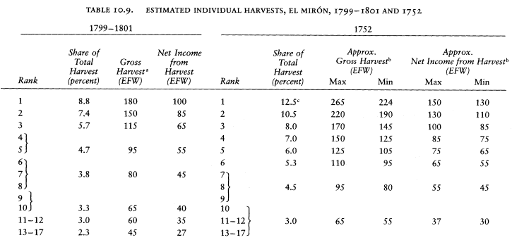
| |||||||||||||||||||||||||||||||||||||||||||||
be classified as shown in Table 10.10, broken down into four groups according to their ownership of land and animals. Although there is no information on the size of their individual harvests, the four groups follow a pattern that can be associated with the one derived from the tithe register half a century later, which I have inserted in the last column of the table. The economy was divided between arable farming and sheep raising, as it was in the medieval community of the French Pyrenees, Montaillou, studied by Emmanuel Le Roy Ladurie.[21] In both places, wealth and social standing were determined by the ownership of land and the ownership of sheep, neither form of property apparently out-ranking the other.
This information can now be used to complete the table of the income of the labradores. Their return from cows, pigs, horses, and donkeys can be divided evenly among them, for most of it came from pigs, and these were distributed fairly much at random among the farmers. This source gave each labrador 16 EFW. Eleven labradores divided the income from sheep, but the top group on average had larger shares, to judge from the tithe register. To the top seven I assign 80 EFW each, to the other four 60 EFW each, using the estimate of income from sheep in
[21] Le Roy Ladurie, Montaillou, 53–54 and passim.
Table 10.7. The smaller estimate, drawn from the reported tithes, would reduce the amounts to 32 and 24 EFW, but I discount these figures.
Those who owned fields collected harvests on them totaling between 18 and 193 EFW annually,[22] from which they would not have to deduct rent. The largest owner was Juan González de la Vega maior, who also had the largest flocks. If one sets him aside, the size of the harvest from the land the other labradores owned was not related to whether they had sheep. It ranged from 18 to 82 EFW, with a mean of 45. To simplify calculations, I shall assume that all landowners except the first received 45 EFW of their gross harvest without paying rent from it. Other farmers, and these farmers on any harvests above this amount, paid 20 percent of the gross harvest in rent, the standard rate for the town.
Finally, one must deduct the cost of pastures and labor. The meadows and the forage grown in cortinas were intended for the cows, horses, mules, and donkeys. The farmers used most of them and their share of the rent would be about 200 EFW (Table 10.8), or 7 EFW per labrador. Sheep would have grazed freely, but the owners of the flocks had to pay the six shepherds, and all shared the cost of the three cow and pig herders. All herders were said to earn two reales per day for 180 days: 24 EFW each. That is about a 2 EFW charge on each labrador and an additional 15 EFW on owners of large flocks and 10 on owners of small flocks. The top group of seven labradores also had labor costs for plowing. All owned four cows or more. Two of these, with six and four yokes, had five resident adult male hands between them, who would cost perhaps 12 EFW each to maintain. With the other five, they probably supported the three jornaleros and three serviciales, for a total wage bill of 144 EFW, to be prorated among the labradores.
All this information has been combined to produce Table 10.11. When income from livestock is included, the position of the farmers appears more favorable; nevertheless their livelihoods are very modest. Only those who owned both fields and sheep lived comfortably at or above the 12 EFW per capita level, and of these the top three or four would have been in a position to save with ease. The labradores who owned sheep but not fields had incomes somewhat above the 12 EFW level, but the owners of fields and no sheep were somewhat below it, and the households of those who owned neither fields nor sheep were well below this threshold, half of them, in fact, receiving less than 6 EFW per
[22] El Mirón, maest. segl.; reported income corrected for understatement.
| |||||||||||||||||||||||||||||||||||||||||||||||||||||||||||||||||||||||||||||||||||||||||||||||||||||||||||||||||||||||||||||||||||||||||||||||
| |||||||||||||||||||||||||||||||||||||||||||||||||||||||||||||||||||||||||||||||||||||||||||||||||||||||||||||||||||||||||||||||||||||||||||||||||||||||||||||||||||||
capita, so far as one can determine from the sources. In sum, only one-quarter of the men called labradores had incomes above the 12 EFW level. These conclusions are based on the higher estimate of income from animals and the mean of the two estimates for income from arable; they are more likely to overestimate than underestimate the household incomes. The data are more shaky than for the other towns we have looked at, but they are not so poor that they hide a thriving agrarian economy. El Mirón was much closer to a subsistence economy than towns in the plains around Salamanca. There was little if any excess grain to export, but the townsmen may have sold some pork in the form of jamón serrano (smoked ham) or chorizo (spiced sausages), specialties of the region even today. Wool was also a commercial product, turned into cloth perhaps by the local artisans, who bought it from the labradores. But there was no need for a large transportation sector, and to point this up, the town had only one muleteer.
3
The other fifteen heads of families in agriculture garnered an even more modest livelihood: jornaleros, serviciales, shepherds, and other herdsmen. All were credited with working 180 days for a daily wage of two reales, 24 EFW per year. All, however, had other recorded income. Each had one or two sows, for a net income from this source of 2 to 3 EFW. Eight owned one or more grain plots, which they probably tilled and obtained net income from harvests of from 0.5 to 7 EFW. (The others, of course, may have cultivated plots they rented, we do not know.) Five of the six shepherds owned goats, all together three-quarters of those in the town, and on average each received 38 EFW from the kids and cheese they produced.[23] Domingo Sánchez de la Calle, a shepherd with ninety-six goats, a sow, and six arable plots, was the most prosperous of these men, with an estimated income of 64 EFW. The other four had known incomes of between 39 and 51 EFW. The remaining ten men in agriculture had a few animals, mostly sows, and a few plots among them, but their known income was hardly more than what their labor brought in. One servicial had a household of 10 (including seven children), but the average household size of the others was a modest 3.8. The shepherds with their own flocks enjoyed incomes at the 12 EFW
[23] This is their share of the larger estimate of income from goats (Table 10.7). The smaller estimate, based on the reported tithes would be 9 EFW each. This is the greatest disparity in any of the estimates; the tithes appear obviously underreported.
| ||||||||||||||||||||||||||||||||||||||||||||||||||||||||||||||||||||||||||||||||||||||||||||||||||||||||||||||||
threshold. The others were well below it, but no worse off than the lower range of labradores, thanks to keeping their households small.
Beside the agricultural sector, the nine artisans of El Mirón were a small group. The catastro reported the income from their crafts as between 24 and 40 EFW (Table 10.12). Except for a linen weaver who was one of the town's two sacristans and received half the first fruits, they had very little additional known income. All kept one or two sows, and four had donkeys. Three owned plots of land, which they probably farmed, for 2 to 4 EFW. Although the fact cannot be discovered from the documents, all probably farmed on the side, adding slightly to their income. If so, with families of four to five members, they lived on per capita incomes of some 8 to 12 EFW, about the same as the majority of people in agriculture (the family of the sacristan-weaver received 15 EFW each). While they made less than artisans in Villaverde, the difference was not so much as between the labradores of the two regions.
El Mirón had the only tailor in the partido, and Santa María was the only other town with weavers, so that the craftsmen had an outside
market available for their goods.[24] If half their products were destined for other towns, they brought 130 EFW into the town economy.
The small tertiary sector was better off and also provided some income for the community. El Mirón's single arriero worked with five donkeys and earned five reales a day for two hundred days (67 EFW). Applying the cost of feeding a beast of burden established for La Mata, 2 EFW, gives him a net income from his trade of 57 EFW. He also owned seven plots from which he could harvest 19 EFW, and a sow. His total income then was about 80 EFW, ranking with the middle range of arrieros of La Mata (Table 7.13). With a family of seven, he was at the 12 EFW level. The catastro tells us, "His regular traffic is to carry wine for this town and nearby places,"[25] a description that underlines the subsistence economy of El Mirón, for he did not transport its agricultural products as part of his normal activities. If half his income from muleteering came from outside, and he bought half his fodder while away, he brought into the town economy 28 EFW.
The barber and surgeon-bloodletter was maintained by the community. Each vecino and each widow with children over fourteen gave him a fanega of wheat per year, and the vecinos of El Collado gave him half a fanega each,[26] a total of sixty-eight. With two sows and two donkeys, which he must have used for travel, his total income was in the range of 73 EFW. Only twenty-three and married with no children, he was well-off and could easily support the twelve-year-old boy servant who helped him in his activities until a son could replace the servant. His maintenance from El Collado brought 10 EFW into the town economy.
The allotment of the blacksmith was more modest, an iguala of fifteen fanegas of wheat and fifteen of rye paid by the town.[27] But the town furnished the smithy, and the vecinos bought him the coal and iron he used, so that he had few expenses. In addition, he farmed and was called also a labrador, although I have not counted him among them. His four plots produced 24 EFW, and an ox, a cow, seven goats, and two sows probably brought in another 7 EFW. He was sixty and married but with no children at home, so that his known income of 56 EFW left him comfortably established. One of the shepherds, thirty-year-old Miguel Martín de Castilla (married, one child), had the same last name and was probably his son, due to inherit the living.
[24] AHN, Hac., Catastro, Salamanca, libro 7476, f. 185.
[25] El Mirón, resp. gen. Q 32.
[26] El Mirón, El Collado, resp. gen. Q 32.
[27] El Mirón, resp. gen. Q 33.
| ||||||||||||||||||||||||||||||
By now it should come as no surprise that among the most prosperous men in the town were its two priests: the curate and the holder of the sinecure, "beneficio del simple servidero." Don Juan Alvarez, the curate, received two-ninths of the partible tithes of the parish (including the anexos). He had to furnish one-thirteenth of this to the fabric of the church, but he also received income from the rent and diezmos privativos (horros) of the properties of his benefice, thirty-two grain plots and nine meadows in El Mirón, for 27 EFW, and other lands in nearby towns for at least another 9 EFW, and he had four sows, two mares, and other animals of his own.[28] The benefice also had a few censos in its favor, from which he got the interest, and it provided him with one of the best houses in the town. His income thus comes out as shown in Table 10.13, some 176 EFW. Don Juan's household included his sister and four servants, two boys and two girls, all of whom he could easily support while living in relative style and putting some coins aside for himself or his heirs.
The sinecure of don Joseph Fernando Pérez was less munificent, for it gave him only a share of the tithes half that of Don Juan, but his personal wealth and industry made up the difference. He owned the most commodious house in the town, seventeen grain plots, three cortinas,
[28] El Mirón, El Collado, Navahermosa, Santa María del Berrocal, maest. ecles.
| ||||||||||||||||||||||||||||||
and four meadows, and a number of animals, including two oxen and four cows. With three yokes and two adult male servants, he evidently tilled his own fields and those of the benefice (and perhaps others that he rented but we have no way to identify). His income was about 180 EFW (Table 10.14). In his household he had a niece and a serving girl as well as his two farmhands.
In this town near the sierra, as in those of the plains around Salamanca, the clergymen's income put them at the top of the economic pyramid (only one labrador had revenues equal to theirs), and their estate placed them socially apart. Their position was even more imposing because there were two of them, supported by the tithes and rents of the parishioners. Only one other person might have been their equal, the town escribano (notary), who, like them, would have been entitled to the appellation don. The post was worth two thousand reales a year (133 EFW) and probably produced considerably more in fees and perquisites, but it was currently vacant.[29] It could not remain so for long, because the partido needed someone to witness contracts and act in official capacities. By the time of the census of 1786, El Mirón had two escribanos.
[29] AHPA, Catastro, El Mirón, libro 549, f. 23, letra F.
Table 10.15 and Figure 10.3 summarize the information developed so far in a socioeconomic pyramid of the town. It reveals a very marginal economy. Almost two-thirds of the households headed by males had per capita incomes below 12 EFW. Even the occupation of labrador, as it was practiced here, did not guarantee an adequate living, for labradores were scattered from top to bottom of the pyramid and 60 percent of them did not reach this threshold. The artisans were low on the scale here as in La Armuña, at least according to the income attributed to them, which, unfortunately, there is no way to check. Perhaps, however, the calculations of individual income have been skewed, and substantial revenues have escaped our household-by-household survey. If so, their existence should become apparent in an analysis of the town economy as a unit.
4
The most obvious impersonal income went to the ecclesiastical funds. The parish church had various sources of outside revenue, the most important one being the tithes and first fruits of its anexos, El Collado and Navahermosa. The rent on the parish lands owned outside the town also went to the church and its two clergymen. Thirteen EFW in rent came from three nearby towns, and one can guess an additional 5 EFW in rents from other towns.
Five-ninths of the partible left the local economy. El Mirón lay in the bishopric of Ávila, and its bishop and cathedral chapter (cabildo ) divided equally three-ninths. The royal two-ninths (tercias reales), which in La Armuña had been ceded to the university, here went to the seigneurial lord, who was then the Duquesa de Alba. In addition, these three authorities received special tithes, small but symbolic amounts. As a form of homage (razón de reconocimiento ), El Mirón and El Collado each gave the duchess 2.5 celemines of wheat, rye, and barley, and the despoblado of Naharra this amount of wheat and rye every third year when its fields were tilled. The bishop received a mejora (enhancement) consisting of one fanega each of wheat, rye, and barley, one lamb, one fleece (interpreted to mean four pounds of wool), and one cheese (two pounds); the cathedral chapter had a fanega each of wheat and rye from Naharra every third year.[30] The Voto de Santiago and the diezmos
[30] El Mirón, resp. gen. QQ 16 and 28, maest. segl., and maest. ecles.; El Collado, resp. gen. Q 16.
| |||||||||||||||||||||||||||||||||||||||||||||||||||||||||||||||||||||||||||||||||||||||||||||||||||||||||||||||||||||||||||||||||||||||||||||
| ||||||||||||||||||||||||||||||||||||||||||||||||||||||||||||||||||||||||||||||||||||||||||||||||||||||||||||||||||||||||||||||||||||||||||||||||||||||||||||||||||||||||||||||||||||||||||
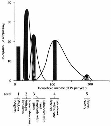
Figure 10.3.
El Mirón, Socioeconomic Pyramid, 1752
NOTE : This is a bar graph based on Table 10.15, with an
indication of dispersion. It is not a set of frequency distributions.
privativos also were paid out. The tithes received from the anexos did not cover all the outside payments, but they meant that the demands of the church bore less heavily on the economy of El Mirón than on the normal parish (Table 10.16).
As before, one should also consider that the parish church spent part of its income outside the town for supplies and expenses. This income was the ninth of the partible and some minor payments assigned to the fabric, the rent on the lands of the fabric and the other endowments. The total is 239 EFW, and one-quarter of this, I have guessed, left the town.
The weight of the payments of El Mirón to its sovereign and its señor was greater than we have previously encountered. The Duquesa de Alba received from the whole partido 7,195 reales for "alcabalas, mostrenco,
señorío, and other rights," the first two being royal taxes that had been alienated to the dukes at some time in the past. Part of this money represented a commutation of twenty partridges, twenty hens, twenty rabbits, and four rams. The towns could not explain what was the share of each, perhaps because an administrator collected it for the duchess for a 6-percent fee.[31] If the share of El Mirón was proportional to its population (in 1752 or 1534), it was some 2,300 reales or 153 EFW. The duchess also received a subsidio y excusado of 191 reales, and El Mirón's share would be about 7 EFW. The king's levies were also considerable. The partido owed 3,931 reales annually for servicio ordinario y extraordinario, but the duchess paid 417 of this as "assistance," for reasons not stated.[32] El Mirón's share of the balance by our calculations was 1,110 reales, or 74 EFW. The crown and the lord between them made off with some 10 percent of the net income from agriculture.[33]
The necessary information to draw up the table of the approximate income of El Mirón as an economic unit is now available, and the result is given in Table 10.16, between a maximum of 2,900 EFW and a minimum of 2,000 EFW, depending on the calculations adopted for the harvest and the income from livestock.
The list of households in the catastro indicates a total population of 312 in 1752. When broken down by age and sex, the population pyramid appears complete, at least for males (Table 10.17 and Figure 10.4). There were nine fewer females than males under twenty-five (10 percent), a difference that can be explained by the departure of girls to work elsewhere, perhaps in nearby Piedrahita, where females aged seven to twenty-four outnumbered males by thirty-five in 1786 (14 percent). A likely maximum figure for the population of El Mirón would be 320. The per capita income, assuming the maximum estimate of town income and the smaller population, is 9.3 EFW. At the other extreme, with the minimum town income and the larger population, it is 6.3 EFW.
Even if one recognizes the poor quality of the physical endowments of El Mirón, the lower estimate is unduly pessimistic. Livestock must have brought a return closer to the figure produced by the general method described in Appendix K than the one indicated by the tithe
[31] AHPA, Catastro, El Mirón, unnumbered folios in libro 549, and El Mirón, resp. gen. QQ 2 and 28 and maest. segl.
[32] El Mirón, resp. gen. Q 27. The duquesa's entry in El Mirón, maest. segl., makes clear that this levy was on the whole partido, not just El Mirón.
[33] Although two lists of royal taxes of the towns of Salamanca province in 1795 give different figures, they confirm the weight of these payments: AGS, Dirección General de Rentas, Hacienda, legajo 2664.
| |||||||||||||||||||||||||||||||||||||||||||||||||||||||||||||||||||||||||||||||||||||||||||||||||||||||||||||||||||||||||||||||||||||||
| ||||||||||||||||||||||||||||||||||||||||||||||||||||||||||||||


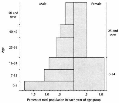
Figure 10.4.
El Mirón, Population Structure, 1752
NOTE : Since there is no limit to the top age groups, a span
of seventeen years for males is used for convenience only.
return. Even the higher estimate, which I judge to be close to reality, leaves the town with less than any place encountered hitherto and corroborates the low household incomes developed above. Perhaps even it is too low. The vecinos may have developed a habit of hiding their real wealth from official scrutiny. Perhaps they did so beyond my ability to detect, but surely they could not do so to the extent of covering up a prosperous economy. There may have been some activities that the census did not record. Some women, for instance, may have spun wool thread for sale on the market, as we shall see below. But this would represent only a minor adjustment in the figures. All the vecinos except a few of the labradores and the two priests lived in or near poverty, victims of the poor, rocky terrain that had centuries earlier made their community the defensive and administrative center of this small corner of Castile and now condemned it to stagnation.
For not all their region was so poor. The three other extant catastros of the partido permit a comparison of their economic condition. The populations, reported tithes, number of animals, and income of the artisans provide rough estimates of gross per capita incomes (far in excess of the net incomes that only detailed analysis can establish; Table 10.18). El Mirón was far poorer than its neighbors, with a per capita income
| ||||||||||||||||||||||||||||||||||||||||||||||||||||||||||||||||||||||||||||||||||||
less than two-thirds of its anexos (but their true incomes would be comparatively lower than the table shows because it does not take into account that all their tithes left their town economies) and four-fifths that of its large neighbor in the valley, Santa María del Berrocal. The comparison goes far toward explaining the long-term demographic decline of El Mirón vis-à-vis Santa María and the partido as a whole, which was observed at the outset. Its economy could not match its position as cabeza de partido.
5
A depressed town in a growing region, El Mirón responded defensively in the next decades. The total population reported in the census of 1786 was 311, almost the same as the number of individuals listed in the catastro. Meanwhile El Collado rose 38 percent, Navahermosa 13 percent, Santa María 65 percent.[34] There are errors in the age grouping reported in the census for El Mirón. All unmarried young people of both sexes except three males were put into the 7–15 age group, which is excessively large, while many married people over twenty-four were put in the 16–24 group (Figure 10.5).[35] It is therefore useless to speculate on the evolution of marriage patterns, but a constant population is not surprising; by 1826 the population had dropped 13 percent (Table 10.1).
The evolution of occupations is also hard to assess. By 1786 the number of men calling themselves labradores had declined, but in 1752 several labradores were marginal farmers so that the difference may not have been real (Table 10.19). On the other hand, the increase in the number of people in agriculture that can be inferred from the large number of jornaleros reported in 1786 reflects a real change, for the tithe register at the end of the century shows about forty-six people harvesting crops, an increase of 60 percent over 1752. Marginal labradores as well as herdsmen and farm laborers were evidently called jornaleros by the census takers.
According to the census, El Mirón had no artisans in 1786. In view of the large number of sheep in the town, however, it is hard to believe that the carders and weavers present a generation earlier had left no successors at all. In 1826, when Sebastián Miñano, the royal geographer, requested information for his dictionary of Spanish towns, El Mirón re-
[34] Compare Tables 10.1 and 10.17.
[35] For the 1786 census of El Mirón, see Appendix N, Table N.6.
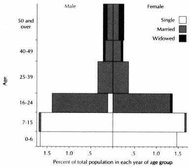
Figure 10.5.
El Mirón, Population Structure, 1786
NOTE : Since there is no limit to the top age group, a
span of seventeen years is used for convenience only.
| ||||||||||||||||||||||||||||||||||||||||||||||||||||||||
sponded that it produced coarse woolens and specialized in the spinning of wool on the wheel, selling black, blue, red, brown, and white thread to other towns and cities.[36] The census of 1786 shows no artisans in any town of the partido, yet Miñano also lists the production of woolen cloth in El Collado, Navahermosa, and Santa María del Berrocal and says a large part of the population of Gallegos de Solmirón was engaged in linen weaving. Since the takers of the census of 1786 did not believe that anyone in the partido fitted the category "artesano," it appears likely that weaving was a part-time occupation and the census classed the weavers as jornaleros. On the other hand, El Mirón's specialty of fine spinning could have been limited to the distaff side, which did not show up with the male occupations in the catastro or the census. Spinning and weaving continued to provide a modest income to the town and the region.
The economy depended as much as ever on agriculture, but there was no growth in output. The average gross harvest projected from the partible tithes of El Mirón in 1799–1801 was 2,027 EFW (Table 10.9n); in 1747–51 it was 2,187 EFW. In fact, the harvest may have been lower than this at the end of the century, for I have assumed a casa excusada (first tither) that did not pay tithes to the parish. The catastro shows a payment to the señor of subsidio y excusado. If the crown had granted the tithes of the first tither (the excusado) to the Duque de Alba at some time in the past, they would not have been collected by the crown after 1760, as happened in the towns studied earlier. My estimate of the harvest in 1800 would then be only 1,869 EFW, 86 percent of that at midcentury.
The farmers had altered their crop mix to no avail. They had reduced their wheat planting, not so much in favor of garbanzos, as in La Mata, but of rye (Table 10.20). The total volume of grain declined only slightly, but rye was worth less than wheat.[37] Had the farmers discovered that wheat was exhausting the soil? Had the climate worsened? I do not know. No growth in income from livestock offset the loss of harvests. The estimated yield of wool in 1752 was 3,342 pounds, of goat cheese 225 pounds. In 1798–1801, the tithes indicate yields of 2,518 and 298 pounds respectively. Ell Mirón was a community in crisis at the end of the eighteenth century. The royal decree placing its ecclesiastical properties up for sale did not catch it at a propitious moment.
[36] Miñano, Diccionario geográfico 6 : 53.
[37] Wheat declined from 186 to 119 fanegas in the partible tithes, rye rose from 186 to 242.
| ||||||||||||||||||||||||||||||||||||||||||||||||
6
The first sale in El Mirón was concluded in October 1800, two years after the decree. The last recorded in this period were made in 1805.[38] Altogether thirty-eight sales disposed of fourteen grain plots, thirty-five meadows (prados), and eight enclosed fields (cortinas) (Table 10.21).[39] According to the catastro evaluation, these properties amounted to only 7.2 percent of the value of the land in the town, far below the 42 percent sold in La Mata or the 19 percent in Villaverde. Ecclesiastical property had amounted to 36 percent of the total in 1752, so that about one-fifth of it was sold. These figures are misleading, however, because most of the lands disentailed were meadows. The prices paid for them, more than one hundred times the catastro value in hard currency, a markup that was six times the average markup for arable and three times that for olive groves (Table E.1), show that they were more highly prized than the catastro evaluation indicated. The commissioner of the Consolidation Fund probably put them up for sale in preference to open
[38] Contaduría, El Mirón (1800); Contaduría, El Mirón (1806); AHPM, C1146, C42461, C42466.
[39] ARPP, Contaduría, sections for El Mirón. Not all sales were recorded here; the following appear only in AHPM: C3229, C7796, C8993, C13193, C15991, C17267, C17919, C17936, C17939, C19582, C19583, C20178, C24830, C29416, C38274.
| ||||||||||||||||||||||||||||||||||||||||||||||||||||||||||||||||||||||||||||||||||||||||||||||||||||||||||||||||||||||||||||||||||||||||||||||||||||||||||||||||||||||||||||||||||||
| ||||||||||||||||||||||||||||||||||||||||||||||||||||||||||||||||||||||||||||||||||||||||||||||||||||||||||||||||||||||||||||||||||||||||||||||||||||||||||||||||||||||||||
fields because of the high price they could fetch, and the effect of the disentail on the town economy would have been greater than Table 10.21 indicates.
Twenty-eight individuals bought land (Table 10.22). Their places of residence reveal that the transfer of property was a local affair in this upland country, far from provincial capitals and major cities. Only one sale went to persons who were clearly outsiders, the sisters doña Ramona and doña Francisca Martín y Thobar of Piedrahita, who bought three properties owned by a memoria in Santa María del Berrocal, two of them meadows in El Mirón.[40] In La Mata, three of the top four buyers were outsiders (who together obtained 30 percent of the land sold); in Villaverde all the top four were outsiders (who together obtained 71 percent of the land sold). In El Mirón three of the top four (who bought 30 percent of the land sold) were vecinos of El Mirón and the other one lived next door in Santa María del Berrocal.
Thirteen of the twenty-eight buyers were vecinos of El Mirón, and the various sources provide information about a number of them. Three of the top six buyers of the town were among the leading tithers, respectable labradores. María Antonia González de Antonia, the largest buyer in the town, was the biggest tither in the book (and thus the second farmer of the town, if there was a casa excusada). Juan González Verguío y Vega, fourth buyer in the town, was just below her, and Juan González de la Vega, sixth buyer, was the next tither. These farmers had net income from harvests of between 55 and 85 EFW (see Table 10.9). By themselves these were hardly adequate resources to explain where they obtained the money for purchases that cost from 6,500 to 11,200 reales (about 160 to 280 EFW), but all three were also owners of livestock, paying wool tithes that indicated that they had flocks of one hundred to two hundred sheep. One can visualize them as members of the top of the four categories of farmers in the town, those who owned both land and sheep, two of them descendants of Juan González de la Vega and Domingo González Verguío, farmers in this category at the time of the catastro. They could well afford their purchases.
It is less easy to explain the source of the money of the other four buyers who appear on the tithe list. Francisco Hernández Vaquero was eleventh tither (net income from harvest about 35 EFW) and had no sheep, yet he was third buyer in the town, spending the equivalent of about 250 EFW. He could not save this out of his harvests, nor would
[40] ARPP, Contaduría, Santa María del Berrocal (1802).
his farming allow him extensive time for another occupation. Did he have some other income, as sacristan, for instance? Gertrudis Cabello, one of the smallest buyers, who joined three others in a purchase of meadows and grain plots, was a widow who farmed and owned about fifty sheep.[41] Although only twenty-fourth among tithers, she may have inherited the 50 EFW of her purchase, or she could have saved it out of current income in less than a decade. Miguel Sánchez Mayoral paid tithes only on chickens in 1800 and on a fanega of oats in 1804.[42] He was clearly not a farmer. Jacinto Martínez de la O had some sheep and raised garbanzos occasionally, but he was not a regular farmer. Yet he bought two meadows for which he paid 2,000 reales in hard currency (50 EFW).[43] Perhaps he was a shepherd. Other members of the de la O family were farmers and may have helped him.
What is more surprising is that a number of buyers do not appear among the tithers, either for crops or animal products. This is the case of Gabriel González Verguío (second buyer in the town), Antonio González Verguío, and Clemente González Verguío, who may have been brothers. Perhaps they were sons of Juan González Verguío y Vega, third tither and one of the main buyers noted above, who gave them money to establish properties of their own. Miguel González Reveriego was one of the smallest buyers; I have no information on him, but Reveriego was a common name among the labradores. Simón Reveriego was fifth tither in 1799–1801. Of Josef Ximénez, who shared two purchases, I know only that he was one of several alcaldes mayores ordinarios of El Mirón in this period.[44] Was he a craftsman? Or retired from active work and the father of Narciso Ximénez, who was fourteenth tither and owned seventy-five to one hundred sheep? Family connections and inheritance must go far toward explaining where those buyers not listed in the tithe register got their funds.
This is not the case for the one remaining buyer of the town. Don Juan Barjacoba y Berguío (or Verguío, like the others) was town notary, the only one at the time of the sales.[45] One recalls that the catastro showed the notary's office to be officially worth 133 EFW per year. Don Juan owned a few animals but did not farm; he bought two meadows.
[41] Identified as a widow in AHPM, C17819.
[42] I recorded the full list of tithers and their payments for 1799, 1800, 1801, 1804, omitting 1802, 1803. Records for 1805–8 were not kept by the parish.
[43] ARPP, Contaduría, El Mirón (1806). He shared the purchase with Francisco Hernández Vaquero.
[44] Identified in ARPP, Contaduría, El Mirón (1803).
[45] "Escribano propio único del número y ayuntamiento de El Mirón," ibid., El Mirón (1798); ibid., El Mirón (1806).
| |||||||||||||||||||||||||||||||||||||||||||||||||||||||||||||||||||||||||||||||||||||||||||||||
| ||||||||||||||||||||||||||||||||||||||||||||||||||||||||||||||||||||||||||||||||||||||||||||||||||||||||||||||||||||||||||||||||||||||||||||||||||||||||||||||||||||||||||||||||||||||||||||||||||||||||||||||||||||||||||||||||||||||||||||
| |||||||||||||||||||||||||||||||||||||||||||||||||||||||||||||||||||||||||||||||||||||||||||||||||||||||||||||||||||||||||||||||||||||||||||||||||||||||||||||||||||||||||||||||||||||||||||||||||||||||||||||||||||||||||||||||||||||||||||||||||||||||||||||||||||||||||||||||||||||||||||||||||||||||||
Curiously, we can know more about the buyers who did not live in the town. Two men from each of the anexos, El Collado and Navahermosa, were among them, and all four turn up in the tithe register. Three were substantial labradores. Although their crops were not large (gross harvests of 70 to 95 EFW), all owned good herds of sheep, from 130 to 400 head. The fourth was more modest, harvesting 20 EFW and owning some 70 sheep. He bought two meadows in El Mirón but nothing in Navahermosa, his home.[46] One of two buyers living in Gallegos de Solmirón farmed grain plots in one of El Mirón's three fields and also paid interest on a fair-sized censo to the parish of Gallegos, indicating that he owned land in his town.[47] The other buyer of Gallegos does not show up in the available records. Five buyers lived in Santa María del Berrocal. The earliest tithe register of this parish to list individual names begins in 1819. In that year four of these men were prosperous farmers with gross harvests between 150 and 330 EFW (assuming that the names still belonged to the same individuals).[48] One of them, Julián Sánchez, bought more property than anyone else in El Mirón; he also owned a flock of 300 sheep. The fifth, don Francisco Hernández Casado, was a priest and holder of a capellanía in Santa María.[49] All of these outside purchasers except the small farmer of Navahermosa also acquired properties in their own towns, and Julián Sánchez, the largest buyer, bought a meadow in Valdemolinos as well. Except for the two sisters of Piedrahita and the priest of Santa María del Berrocal, all outside buyers whom one can identify were farmers in neighboring towns who were adding to their holdings. In El Mirón they sought primarily meadows and enclosed fields on which they could support their animals (Table 10.21). In this region prosperous labradores readily crossed town lines in their activities, especially to sustain their livestock.
The purchases across town lines provide another, more revealing lesson. Table 10.23 and Figure 10.6 give the relevant information, based on all the sales recorded for El Mirón and five surrounding towns.[50] In El Mirón, where sales involved more money than in any of the other towns, 60 percent of the disentailed property belonged to endowments and funds located in its parish church, but its vecinos bought only 48
[46] Ibid., El Mirón (1802, 1805, 1807); AHPM, C3228, C17267, C19581, C24830.
[47] Josef Sánchez Lucas, El Mirón, Cuentas de diezmos, 1801, 1804; Archivo Parroquial, Gallegos de Solmirón (Ávila), Censos 1799–1800.
[48] Archivo Parroquial, Santa María del Berrocal (Avila), Tazmía, 1818–37.
[49] Identified in ARPP, Contaduría, El Mirón (1806).
[50] ARPP, Contaduría.
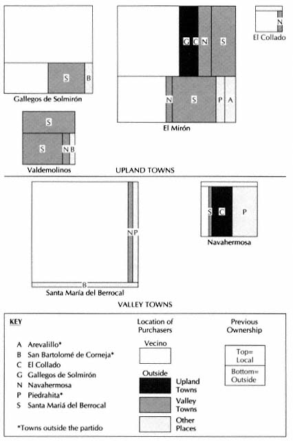
Figure 10.6.
Partido of El Mirón, Purchases of Disentailed Properties, 1800–1805
NOTE : Areas are proportional to the amount of the sales in the town (see Table 10.23).
percent of the property sold.[51] The town economy was a net loser. (Of the properties that were sold, they got slightly more than half those that belonged to their church, but less than half those of outside parish funds.) Vecinos of all nearby towns except Valdemolinos, a tiny place of forty-six people in 1786, shared in the purchases of its lands.
By comparison, in Gallegos de Solmirón 67 percent of the property sold belonged to local church funds, but the vecinos bought 84 percent of the property: all the properties of their church and half the rest. They also bought some property in El Mirón, coming out well ahead on the disentail.
The picture in Santa María del Berrocal, the expanding town in the valley, was more complex. Its economy lost out in the sales in El Mirón, its church owning 36 percent of the property sold in El Mirón and its vecinos buying only 26 percent, and also in Gallegos, where its church was the only outside owner to have properties sold, half of them, as was said, going to vecinos of Gallegos. To judge from the pattern of sales in the five towns, religious funds in Santa María had gained considerable hold over the economies of nearby towns before the disentail began. Since these funds had been formed by bequests from the faithful, in the past either its vecinos had bought outside lands that they then donated to their own religious funds, or landowners in nearby towns had preferred to invest in their celestial future by giving to the parish of this prospering town rather than to their own. Probably the former was the case, but either way, Santa María had been economically expansive. Only 4 percent of the lands sold within its limits belonged to an outside fund, located in Piedrahita, the largest town in the region.
Well placed before the sales, the economy of Santa María lost some through the disentail within the region studied. Properties that its church owned in other towns were sold for 97,644 reales, its vecinos bought lands in these towns that went for 73,433 reales. I do not know about sales in other valley towns, including Piedrahita. In Santa María itself there was a slight loss of about 8,000 reales, most of the outside purchases being made from Piedrahita. By comparison, even though outsiders bought much property in El Mirón, its vecinos bought absolutely nothing in the five towns nearby.
Figure 10.6 shows graphically the meaning of these exchanges. Vecinos of upland towns, except El Mirón and Valdemolinos, made purchases in other upland towns, but they made only one purchase in the
[51] All percentages are based on sales prices.
| ||||||||||||||||||||||||
valley (by a vecino of El Collado in Navahermosa).[52] Vecinos of valley towns bought lands in other valley towns, but they also bought lands in upland towns. Perhaps residents of the upland towns made purchases in other valley towns that I have not studied, but it is highly improbable that any such purchases would have negated the pattern observed here.
In the eighteenth century the changing demand for agricultural products and the growth of rural population gave comparative economic advantage to towns with good farmland. Rough as they are, the figures in the catastro for the value of agricultural land show this. The mean annual product of a measure of land (a fanega or its local equivalent) in upland towns was lower than in valley towns (Table 10.24). The towns of the region that were engaged primarily in farming had the economic strength to profit from the disentail at the expense of those dedicated to pasturage.
To judge from the tithe register of El Mirón, the disentail confirmed and solidified a development already taking place. During the three-year cycle 1799–1801, fifty farmers from seven outside towns paid tithes to the parish for harvests within its limits (not including farmers of Navahermosa and El Collado, which were part of the parish). Sixteen of them
[52] A vecino of El Collado (upland) participated in the purchase of a large block of lands in Navahermosa (valley) belonging to a fund in Piedrahita, the rest of the lands going to a purchaser in Piedrahita. The records do not indicate how the shares were divided. Table 10.22 and Figure 10.5 are based on a hypothetical equal division, but the vecino of El Collado may well have got less than half.
had harvests in more than one year of the cycle. Their payments indicated a total average annual harvest of some 330 EFW. At the time of the catastro individuals living in nearby towns did not own nearly enough land to produce such harvests (Table 10.6). Unless vecinos of El Mirón had sold much land to outsiders in the intervening fifty years—hardly likely—outsiders were renting plots within the town, probably from church funds. Was this a recent development? I have no information, but I suggest that it was a practice that had been growing as El Mirón got relatively poorer. The sales continued the outside takeover. The partido of El Mirón is the clearest case we have seen of disentail accelerating a regional redistribution of economic resources that had already been going on despite restrictions on the free exchange of property.
After the desamortización of Carlos IV, the decline of El Mirón continued. By 1826 its population was down to 270 from 311 in 1786, and it had less than 18 percent of the population of the partido, compared to 26 percent in 1786 (Table 10.1). Santa María increased from 517 in 1786 to 780 in 1826 and now had nearly 52 percent of the people in the partido (against 44 percent in 1786). Administrative reorganization added to El Mirón's woes. By 1826 its two anexos, Navahermosa and El Collado, had parishes of their own.[53] In 1833 its towns were incorporated in the partido of Piedrahita and El Mirón ceased to be a cabeza de partido. Santa María, with its rich fields and major road, on the other hand, had its municipal boundaries extended to include Navahermosa and, by the twentieth century, Valdemolinos as well. If, as was suggested earlier, one can see here in microcosm the national conflict between the harsh Castilian meseta and the lower, more commercial periphery, an oversimplified comparison but one of some validity, the history of this small partido suggests that after the eighteenth century only the persistence of government institutions and patterns of authority inherited from earlier times made possible the continued dominance of upland Spain over lowland Spain.
[53] Miñano, Diccionario geográfico 3 : 147, 6 : 223.
Chapter XI—
Baños
The rugged surface of the Iberian Peninsula affords only two easy routes between Andalusia and Castile. One, in the west, runs north from Seville to Mérida in Extremadura. It was the route preferred by the Romans, who from Mérida continued it over the central sierras to Salamanca and León. After the Visigoths made Toledo the capital of Iberia, this route lost its primacy in favor of one to the east. Leaving Seville, it follows the valley of the Guadalquivir to the town of Bailén in the province of Jaén and then turns north to pass through the Sierra Morena where it is relatively easily crossed into La Mancha, and thence it has an almost flat course to Toledo and Madrid. Between these two roads, the low, broad, labyrinthine ranges of the Sierra Morena separate Castile from Andalusia.
Today the main railroad and highway from Madrid to Andalusia follow the eastern route and traverse the sierra through the pass of Despeñaperros, a spectacular, narrow, rocky gorge beneath overhanging peaks, on which, its name suggests, even dogs lose their footing. Great human effort was needed to make it passable for anything but pack animals. This effort was undertaken in 1779 at the initiative of the Conde de Floridablanca, who engaged a French engineer to blast a road beneath the precipices, to the awe of contemporary travelers. Before then the main road crossed higher but easier terrain by way of El Viso del Marqués, the last town in La Mancha, which lies five kilometers to the west of the present road.
Since the Middle Ages this line of communication has been of great
commercial and military value, used by travelers, merchants, and armies descending from Toledo and Madrid to Seville, Cádiz, and beyond to America, or heading north toward the capital. After passing south through the Sierra Morena the old and new roads join at Las Navas de Tolosa, scene of the critical Christian victory of 1212, which opened Andalusia to reconquest. Six centuries later, in 1808, Napoleon's troops under General Dupont, marching to subdue southern Spain, succumbed to a superior Spanish army near Bailén. To make this highway safe from bandits and to bring a desolate region into cultivation, Carlos III founded the colonies of Sierra Morena, one of his most successful undertakings, which provided fame and ultimate tragedy to their director, Pablo de Olavide, as we observed in Chapter 1.[1]
At the time of the catastro these colonies were not yet there, and the road between Las Navas de Tolosa and Bailén ran most of the way through the término of Baños. The first two inns south of the pass of Despeñaperros were located here, the large Venta de Miranda that travelers stopped at just beyond the pass, and the smaller venta at Guadarromán, halfway down the slopes. From there, the road skirts a little to the east of Baños itself, for its nucleus, like many in Andalusia, is located on the top of a hill, easily accessible from only one side.
The nucleus is built on a low spur of the Sierra Morena. At the southern tip of the spur, about 425 meters above sea level, rises a castle of Muslim origin, reputed to date from the tenth century. With its thick walls and high square keep, this imposing bastion guarded the Andalusian valley from marauders of the north. The low, white houses of the town cluster on the crest of the hill behind it, like chicks snuggled to their mother. Close beside the castle is the main square, a small affair dominated on its opposite side by a Renaissance church with an octagonal bell tower crowned by a curious tapered dome, like the pointed end of an egg. Farther along the crest, the hermita, or sanctuary, of El Cristo de los Llanos stands at a distance from the eighteenth-century town.
From the top of the castle keep, a lookout can dominate the region in all directions. To the west, the promontory it sits on falls rapidly off toward the rugged valley of the Rio Rumblar, and beyond are barren, steep hills, good only for meager grazing. To the north rises the rolling, wooded Sierra Morena, and in the opposite direction, between two hills, a sharp valley leads off to the southwest and the Guadalquivir.
[1] For the roads see the map of Jaén in Biblioteca Nacional, Tomás López, "Atlas particular," tomo 1; Bourgoing, Travels in Spain 1 : 374–76; Laborde, View of Spain 2 : 4–7. On the colonies, above Chapter 1, section 6.
Only to the east does the view suggest the wealth that supports Baños, for eighty meters below the castle and town, a broad, flat valley known as lo llano stretches four kilometers to the east and twelve kilometers north and south between the town and the Madrid highway. Beyond the road the land to the east rolls gently, and the mining city of Linares is visible from the castle, fifteen kilometers away. The plain is of deep red earth, typical of the Sierra Morena, and today it is covered with a patchwork of grain fields and olive groves.
Although lo llano formed the heart of Baños's agriculture, it was but a fraction of the término, which stretched six and four-fifths leagues north and south according to contemporaries and six and one-quarter east and west. Translated into thirty-eight and thirty-five kilometers respectively, these estimates were slightly high, but not far off (Map 11.1). The northern limit was the province of La Mancha, twenty-eight kilometers from the town nucleus. Most of this territory was in the Sierra Morena and barren or used only for pasture and occasional crops.[2]
In Andalusia in the eighteenth century, as today, towns were bigger than in Old Castile in population as well as in extent. In 1752, according to the catastro, the villa of Baños had 306 houses, plus 14 others uninhabitable or in ruins. The town hall (casa de ayuntamiento ) faced on the square and housed the jail and town granary (pósito). The town also owned on the square a public butcher shop and a slaughterhouse.[3] The populace provided enough business to support two taverns, one of which sold olive oil, vinegar, and spirits (aguardiente ), three grocery stores (especerías ), nine bakers, and two dealers in soap.[4] At a distance from the nucleus and nearby plain but within the término, fourteen cortijos or rural estates housed a few permanent residents.
The books of households list 1,779 people in Baños in 1752 (Table 11.1). The numbers suggest a marked underreporting of females, especially single women. (The books show 407 sons of all ages living with their parents and only 341 daughters.) Some young women may have gone away to work (but where?); still, one can safely add 50 women to the population without exaggerating its true size. This gives a total of about 1,830. Baños had 437 lay vecinos: 281 married men, 39 widowers, 85 widows, and 32 single men; 12 clergymen were heads of household, and three clergymen lived alone.
The occupations of the vecinos reveal a more complicated social
[2] AHPJ, Catastro, Baños, resp. gen. Q 3. Baños was bounded on the north by the villas of El Viso and Mestanza, both in La Mancha.
[3] Baños, resp. gen. Q 23 and maest. segl., f. 275v.
[4] Baños, resp. gen. Q 29.
Map 11.1.
Province of Jaén Under the Old Regime, Town
Limits of Baños, Lopera, and Navas de Santisteban
structure than that found in the small towns of Salamanca (Table 11.2 and Figure 11.1). For the first time we find a group of hidalgos, and the clergy were numerous. Nevertheless, more than two-thirds of all the adult men were engaged in agriculture, while only 8 percent were artisans, a smaller proportion than in either Villaverde or El Mirón. The list of occupations indicates that the income of the community came almost entirely from the land.
As might be expected in a territory as large and varied as that of Baños, the land was put to many uses. The total recorded size of the término was 156,797 fanegas (75,500 hectares).[5] However rough this
[5] Baños, maest. segl., ff. 2r–4v, appears more accurate than resp. gen. Q 10, which says about 144,000 fanegas. The fanega here was equal to 0.482 hectare (ibid. resp. gen. Q 9; see Table N.5).
| ||||||||||||||||||||||||||||||||||||||||||||||||||||||||||||||||||||||||||||||||||||
figure may be, it reveals the enormity of the area of Baños, for it is almost 60 times El Mirón, the largest town in Salamanca we have studied, and over 150 times La Mata or Pedrollén. Because Baños ran back into the Sierra Morena, much of its territory was barren and unused—40 percent, the catastro calculated—while ten pastures (dehesas) belonging to the town council made up another 37 percent. The three largest pastures stretched across the northern edge of the sierra, 47,000 fanegas, almost half of them judged quite barren. The other seven were small, between 300 and 600 fanegas, but of better quality, with part planted in live oaks.[6] The use of two of these pastures belonged to the cities of Baeza and Bailén by ancient agreement.[7]
Although only one-quarter of the término was cultivated, this was still forty times the area of La Mata. Again, however, this figure is deceptive. Seven-eighths of the cultivated land was located in the término privativo, a type of property we have not previously encountered. According to a privilege granted the town shortly after the reconquest of Andalusia by King Sancho IV (1284–95) and confirmed regularly by
[6] Baños, maest. segl., ff. 274r–276v.
[7] Baños, resp. gen. Q 10; maest. segl., f. 276r–v.
| |||||||||||||||||||||||||||||||||||||||||||||||||||||||||||||||||||||||||||||||||||||||||||||||||||||||||||||||||||||||||||||||||||||||||||||
| ||||||||||||||||||||||||||||||||||||||||||||||||||||||||||||||||||||||||||||||||||||||||||||||||||||||||||||||||||||||||||||||
Figure 11.1.
Baños, Employment Structure, 1752
kings up to Felipe V, about one-third of the town limits, a block of marginal land stretching across it from west to east south of the mountain pastures and running down the eastern edge was set aside to be distributed to the vecinos individually to till free of charge. They received only the use of the land (dominio útil) and lost it if they did not cultivate it within certain stated intervals. After deducting a fifth of the término privativo that was barren and another fifth good only for pasture, about 30,000 fanegas remained that could be planted about once every twenty years, fertilized by the ashes left from cutting down and burning off the undergrowth (monte bajo ) that had grown up in the intervening period. This form of primitive slash-and-burn agriculture was known as roza de cama.[8] Only a small part of the término privativo was planted regularly, however. The catastro indicates that in the current year individuals had sown about 160 fanegas of it.[9] If this was representative, over a twenty-
[8] Baños, resp. gen. QQ 10, 12. "Roza" is a general Andalusian term for land that is burned off and sown (see Bernal and Drain, Campagnes sevillanes, 65). In the eighteenth century baldíos in Extremadura were being turned into rozas, "which can be exploited, some every eight years, others every ten, twelve, or twenty years" (quoted in Rodríguez Silva, "Venta de baldíos").
[9] Baños, maest. segl., totals. Resp. gen. Q 10 says about 80 fanegas were planted, but this, stated by the town officials as a global figure, seems less reliable than the sum of the reports of the individual vecinos.
year cycle barely one-tenth of all the land available would have been planted. Yet roza de cama was reputed to produce a harvest of 8 fanegas of wheat for each fanega of area, higher than any other land in the town. The término privativo also contained 2,000 fanegas of better quality soil, which could be planted once every five years with wheat, barley, or rye after burning the small growth of underbrush, in a rotation known as roza de barbecho. About a fifth of this section of it was cultivated in the current year, indicating that most of it was in use. Finally, 957 fanegas of the término privativo were good enough to have encouraged those who exploited them to build cortijos in their lands, permanent buildings to shelter animals and seasonal workers. For example, one cortijo of 120 fanegas, which belonged to a priest of Baños, consisted of two sheds to protect workers, donkeys, and cattle "at the time of planting and harvesting," a hay rick, two corrals, and a paved threshing floor.[10] Despite the terms of the royal grant, there were fourteen "cortijos de sierra" in the término privativo, so well established in the hands of the current holders that the catastro treated them as private property. Here harvests ranged from two crops of wheat every three years to one crop of rye every four years.
The catastro indicates that only about 3,000 fanegas of the término privativo were planted at all regularly. Together with the 4,244 fanegas that were cultivated under private ownership, about 7,250 fanegas produced crops. This is 4.6 percent of the entire término, but still seven times the area of La Mata. Since the population was slightly more than seven times that of La Mata, the cultivated land per head was about even. As will become apparent, however, the similarity did not extend to the per capita income. La Mata at midcentury was a flourishing, little-stratified community despite the outside ownership of most of its land. Baños, Andalusian to the core, had a vastly different economic and social structure.
The private property was located relatively close to the town nucleus, mostly in lo llano. Twelve hundred fifty fanegas of private property were planted in grains. The best quality fields were in the ruedo, 266 fanegas of cultivated land lying in the immediate vicinity of the town nucleus. First-class ruedo land was sown in a three-year cycle, 1 fanega of land producing six fanegas of wheat, eight of barley, and six of habas (broad beans) in successive years. Second-class land gave only two crops in three years: five fanegas of wheat and seven of barley; while third-class
[10] Baños, maest. ecles., ff. 24–30.
land could be sown only once every three years with wheat, giving a harvest of six fanegas. Beyond the ruedo, in the campiñuela, 987 fanegas in extent, private lands varied greatly in quality, from the best that produced three harvests in three years—five fanegas of wheat and two harvests of six fanegas of barley—to fourth-class land that yielded only two crops in eight years, six fanegas of barley and five of rye. Over half the ruedo was first class, but only one-fortieth of the campiñuela. The extent of property tells little about its worth, since "quality" as defined by the catastro was crucial.
Of the private land 2,760 fanegas, or 65 percent, was planted in olives, about 119,000 trees, which produced the most valuable harvest in the town. The catastro does not state how the olive groves were located spatially with reference to the arable. Close by the nucleus, in the ruedo, were a number of orchards and huertas. They were irrigated by streams or norias (wells with waterwheels worked by donkeys or mules).[11] Their figs, pears, cherries, chestnuts, pomegranates, peaches, lemons, oranges, mulberries, and as many other fruits again, and their vegetables—turnips, cabbages, eggplants, tomatoes, cucumbers, peppers, garlic, onions, and lettuce are listed—were of high value, but the extent of their cultivation was limited. Verdes de cebada and verdes de centeno (barley and rye planted yearly and harvested green for fodder) were also grown in small parts of the ruedo.
The use of the land in Baños conformed closely to the pattern conceived in the early nineteenth century by the German geographer Johann Heinrich von Thünen. Based on the experience of his own estate near the Baltic Sea, he demonstrated that if a nucleated settlement or farmstead was surrounded by land of even quality, its use would be distributed in a series of concentric rings around the nucleus. Economic efficiency would dictate that the crops requiring the greatest amount of labor, fertilizer, and other inputs, including transport, would be located closest to the nucleus. The total expense in inputs compared with its price in the market would determine how far from the center each crop or form of exploitation would be. Thus intensive cultivation like horticulture would be closest to the nucleus, intensive arable rotation would be farther out, followed by arable of less frequent rotation, with grazing and ranching at the greatest distance. Of course, in a real situation the quality of the land, physical impediments to cultivation and communication, the availability of roads, and other local features would modify
[11] Baños, resp. gen. Q 4.
| |||||||||||||||||||||||||||||||||||||||||||||||||||||||||||||||||||||||||||||
the rings into zones of irregular shape.[12] Much of current location analysis originated in von Thünen's insight. Recent studies have shown that in fact the large agro towns of Sicily and southern Spain offer excellent examples of his rings.[13]
Baños in the eighteenth century was precisely such a case, although its location in the foothills of the Sierra Morena obscured the character of the "rings." The ruedo land immediately beneath the hill on which the town was clustered and the streams in its vicinity held the irrigated huertas for vegetables, which demanded nearly constant attention, and the orchards, which had to be watered regularly and whose fruit had to be watched and picked as it ripened. The most intensive grain cultivation also took place in the ruedo, over half of it sown every year. Only a tiny portion of the campiñuela, located beyond the ruedo, was sown every year, and much of it only once every four years. Table 11.3 shows effectively the difference in the crops harvested in the ruedo and campi-
[12] J. H. von Thünen, Der Isolierte Staat in Beziehung auf Landwirtschaft- und Nationalökonomie (Rostock, 1826). For a discussion of von Thünen's theory, see Chisholm, Rural Settlement, 21–46.
[13] See Chisholm, Rural Settlement, 60–65.
ñuela, with habas only in the former and rye only in the latter. Beyond these zones stretched the término privativo, cultivated even less intensively, the roza de barbecho once every five years, the roza de cama reputedly only once in twenty. But within the término privativo, no doubt influenced by the availability of water, cortijos had been carved out, each an independent nucleus with its surrounding rings of cultivated land and pasture. Finally, the most distant land, along the northern limits of the town in the depths of the Sierra Morena, was devoted to pasture. But again, the better pastures, where the inhabitants had planted live oaks for additional fodder, were closer to the town nucleus. The makers of the catastro defined the use of the land by its "quality," but in fact, the primary determinant of its use, after the most obvious natural qualities, was the ease with which it was exploited and the relation between the cost of exploitation and the market for agricultural products. Today much of the término privativo, considered of marginal value in the eighteenth century, is covered by some of the richest olive groves in Jaén. Of course, the same consideration applied to land use in all the towns studied here, but the von Thünen effect becomes more obvious when the area of the town is vaster.
The economy of Baños rested on two major crops, grains and olives, while grapes, fruits, and vegetables offered a secondary source of income. The total recorded product of the various olive groves was 14,600 arrobas of oil per year.[14] In addition, the catastro specifies 155 fanegas of vines, reported to produce 682 arrobas of wine per year.[15] As usual, we can check these estimates against the tithes; they turn out to be too high. The catastro says that the tithes were about 900 arrobas of olive oil (worth 14 reales each) and 40 of wine (at 6 reales),[16] but evidently no accurate record of the tithes was available, for they were collected not by agents of the church but by private individuals who farmed this source of revenue. They paid 13,000 reales per year for this right.[17] Since the listed tithes add up to only 12,840 reales, the tithe farmers must have collected more than the catastro says. If we assume that they calculated a 10-percent margin for expenses and profit, they must have counted a total receipt at least 11 percent more than the stated tithes. We can therefore estimate that the true tithes were collected on an annual harvest of 10,000 arrobas of oil and 450 of wine. To these must be added
[14] An arroba of volume is 12.56 liters.
[15] Baños, maest. segl., letra C, ff. 1–9.
[16] Baños, resp. gen. Q 16.
[17] Ibid.
| |||||||||||||||||||||||||||||||||||||||||||||||||||||||
324 arrobas of oil from groves of ecclesiastical ownership that were exempt from tithes. Since the fanega of wheat, like the arroba of oil, was worth 14 reales,[18] the oil harvest estimated from the tithes is 10,324 EFW and the wine harvest 193 EFW.
Table 11.3 shows the annual grain harvest that can be predicted from the information on the extent of the different qualities of land and their stated annual harvests. The total harvest represented by the tithes is 89 percent of this amount, as shown by Table 11.4. The two tables agree exactly on the wheat harvest, but the tithes indicate harvests of barley and rye that are only 72 and 45 percent of those predicted. I shall, as usual, take the reported tithes as a safer indicator, although we have seen that this source may not be reliable.
The yield-seed ratio for wheat in the ruedos and campiñuela, according to the catastro, varied between 4.8 : 1 and 7.2 : 1, and in the cortijos de la sierra and the roza de barbecho between 5 : 1 and 9 : 1. For the roza de cama, planted once every twenty years, the information supplied results in an incredible 24 : 1 ratio (8 fanegas of wheat from .33 fanega of seed). Since this is in the realm of the impossible, even with the ashes of undergrowth as fertilizer, I shall assume a ratio of 12 : 1. The mean yield seed ratio for wheat is 7.5 : 1 (but only 5.1 in the ruedo and campiñuela alone). Barley ratios were between 5.1 : 1 and 8.0 : 1 (mean 5.9 : 1), habas
[18] Ibid. Q 14.
| ||||||||||||||||||||||||||||||||||||
| |||||||||||||||||||||||||||||||||||||||||||||||||||||||
5.1 : 1, and rye between 6.0 : 1 and 7.7 : 1, except in the roza de barbecho, where the catastro reported 15 : 1 (mean 7.7 : 1).[19] Table 11.5 indicates the total seed needed. The gross harvest less seed results in a net harvest of 5,370 EFW, hardly more than half the income from the olive groves.
Table 11.6 lists the value of the minor crops harvested from the orchards, huertas, and planting of green forage. How accurate are these figures? Apparently fairly close. The collection of the tithes on vegetables (hortalizas ) was rented for 500 reales, indicating, when account is taken of expenses and profit of the tithe farmer, a harvest worth 5,500
[19] Ibid. Q 9 for seed needs, Q 12 for yields.
reales, very close to the 5,608 shown in the table. Since vegetables and fruit could be consumed and the seeds saved as well, there is no seed requirement, while the seed for green barley and rye would come out of the regular harvest at roughly 7 : 1. The net return for all these crops was 1,126 EFW.
2
The total net return from agriculture came to about 17,000 EFW, according to these calculations (Table 11.17). How much of this went into the town economy depended to a great extent on how much belonged to outsiders and how they administered their share. The ownership of land was distributed as shown in Table 11.7 and Figure 11.2.
A revealing feature of the catastro of Baños is that it names the tenants of ecclesiastical lands and gives their reputed income (that is, total income less rent). Unlike the returns we have looked at from Salamanca province, which specify rent as so much grain per measure of arable, that of Baños assigns 75 percent of the annual product to the tenant and 25 percent to the owner, regardless of the crop. Unfortunately, I have found no account books giving actual rents in Baños, so that I have no independent check on this rule of thumb. It is, however, confirmed by the report of the intendant of Jaén published in the Memorial ajustado of 1784, which states that it was standard practice in the province for the owner to get one-quarter of the harvest. In Córdoba the landowner's share was said to be slightly less, two-ninths of the harvest.[20] The intendant of Jaén said that the owner got one-fourth of the grain harvest up to eight fanegas of grain per cuerda (fanega) of land. If the tenant managed a higher return, the excess was his. Out of his share, he had to pay the expenses of tithes, seed, tools, and human and animal labor.
Although I have found no account books for Baños, the Archivo Histórico does have a book for the convent of nuns of the Holy Trinity of Alcalá la Real from 1799 to 1807, with a few entries as late as 1819.[21] Alcalá la Real is across the province of Jaén, located in a fertile valley on the border of Granada, a larger and richer place than Baños. Nevertheless, the methods of administration followed by the Trinitarian nuns were probably close to those used in Baños. They differed in a number of respects from the practices of Salamanca province.
The book was kept by an administrator or steward, to whom the
[20] Mem. ajust. (1784), §721; §719, 235.
[21] AHN, Clero, libro 4670.
| ||||||||||||||||||||||||||||||||||||||||||||||||||||||||||||||||||||||||||||||||||||||||||||||||||||||||||||||||||||||||||||||||||||||||||||
nuns had entrusted the management of their estates, don Domingo Antonio Saenz de Texada. The book does not specify his commission, but he must have served much as the administrators we shall observe later in Baños. He was probably not a priest, for he is not given the title Pbro. Under his care, the lands were let out by contract. When the length of the lease is mentioned, it is four years, that is, two two-year rotations. As in Salamanca, rents were to be paid on 15 August, feast of the Assumption of the Virgin.
Almost all the contracts fitted one of three patterns (Table 11.8). The
Figure 11.2.
Baños, Ownership of Land, 1752
first applied primarily to cortijos, of which the convent owned nine. The extent of six is specified: from 94 to 267 fanegas, with a mean of 164, good-sized properties that needed a labrador of substance to take them on. From them the convent received two parts of seven of the harvests of wheat and barley, and one-fourth of the other crops.[22] The tenant also
[22] "Pagando de trigo y zevada de 7 f.s [fanegas] dos, y de semillas al quarto" or " . . . y de qtas [cuantas] semillas y hortalizas siembre de quatro una."
| |||||||||||||||||||||||||||||||||||||||||||||
paid a fixed monetary rent and two turkeys at Christmas for the use of the cortijo buildings and a sum to be assessed (by an independent agent?) for the pastures.[23] Only two cortijos had a different rental rate—for wheat, one of two parts in six, and for barley, one of two parts in seven and a half.
These shares also applied to five contracts covering individual fields (hazas ), but most fields were rented under two other standard contracts. In nine cases, the rule was one-quarter of all crops to the owner, in other words the contract that was considered standard in Baños and in the province as a whole according to the intendant. Even more common for hazas, however—thirteen contracts—was a fixed annual rent ("renta fixa anual") payable almost always in wheat (once only in coin), the kind of arrangement we have become familiar with in Salamanca. What was the basis for the difference? Evidently much depended on the quality of the land. The five fields whose rent was a share greater than one-fourth of the harvest were small plots of high quality. The rental payments recorded on these indicate harvests every other year of almost ten fanegas of wheat per fanega of land. The highest harvest we have observed previously was in La Mata, eight fanegas of wheat per fanega of first-class land every other year.[24] The rate of one-fourth of all crops was used for fields of poor quality and large size, where other cereals besides wheat had to be planted and the yields were comparatively low. Finally, the fixed rate, payable in wheat, which was most common, applied to
[23] "El monte por aprecio."
[24] The fanega of land was almost identical in the two places (Table N.5).
the fields of middling size and quality, which regularly produced wheat out of which the rent could be paid.
Not only the quality of the land was involved in the choice of terms, however; the tenants of the hazas leased for a share of the crops tended to stay on longer than those who paid fixed rents. In the period covered by the account book (which varies from two years to twenty, depending on the property), the names of the sharecropping tenants can be followed in twelve cases. In six, the same man was tenant throughout, in four the tenant changed once and in two, twice. In the last cases, the second tenants (the only ones whose length of occupancy is known) farmed the plots five and six years. But of nine cases of lots with fixed rent, never was the same man tenant throughout; in one instance the tenant changed three times (in four years), and in another four times (in eleven years). These tenants must have been looked on as unreliable or impoverished, men who could not be depended on to keep an exploitation going and had to be held to specific terms. It comes as something of a surprise to discover that sharecropping was considered a preferable arrangement to leasing for a fixed rent, but this conclusion is supported by the terms afforded to lessees of cortijos, who also leased for a share of the harvests and stayed on a long time, men who approached the big "labrador" of whom Carlos III's reformers complained. Of six cortijos, in two the same man was tenant throughout the period covered by the book (nine and twelve years); in two the tenant changed once (the first tenant of one had occupied it for at least nine years); and in two a relative of the tenant took up the lease—a son-in-law and the widow's next husband.
The convent evidently divided its tenants in two classes, those who were steady, loyal, and able to finance their exploitations and those who could not be counted on. To the former it offered more desirable properties with arrangements to share the harvest, and they stayed on and even passed their leases to their heirs. From the latter it demanded a fixed rent and dismissed them promptly if they failed to pay. The former would be reliable labradores, the latter jornaleros and pegujaleros (small farmers). In Córdoba, where the cathedral chapter collected two-ninths of the harvest on its cortijos in bad years (with a fixed specified payment in oth er years), it sent to each cortijo in the bad years two trusty men (fieles) with instructions that they should not both sleep at the same time.[25] Perhaps the convent of Alcalá la Real adopted similar precau-
[25] Ponsot, "Rendement des céréales,"476–77.
tions to ensure that the tenants paid them their full due, but they had already made a selection before entrusting a farmer with a cortijo. No doubt the convent preferred to state a specific fraction of the harvest as a guarantee of obtaining all it could and the tenant to protect himself against poor yields. In Salamanca province the owners wrote contracts for fixed payments with tenants who stayed on for years and whose heirs inherited the leases, the kind of person who sharecropped in Jaén; clear evidence here that one cannot project the practices of one region of Spain to others.
One does not know on what basis the nuns calculated their fixed rents, but most sharecropping contracts called for either 25 or 28.6 percent of the harvest. Whatever the actual arrangements were in Baños, it seems safe to proceed on the assumption that the owner who leased his lands got one-fourth of the harvest, as the catastro says, even if the actual payments varied somewhat from this norm.
Nevertheless, his net benefit appears to have varied according to the different crops. This is the conclusion that can be drawn from the different proportions of each kind of land that the ecclesiastical institutions of Baños chose to lease or to cultivate themselves. Lands not leased would have been farmed with hired labor and either administered directly if they belonged to local institutions or by a paid administrator if the institution was located elsewhere. Table 11.9 shows that religious institutions were much more likely to lease their grain fields and huertas than their olive groves and vineyards. One may assume that the institutions preferred the method of exploitation that they had found economically
| ||||||||||||||||||||||||||||||||||||||||||||||||||||||||||||
most advantageous, other things being equal. If this is so, owners of olive groves and vineyards could usually make more than the lessor's standard 25 percent if they were in a position to oversee the exploitation directly. Conversely, 25 percent in rent was a bigger share than the owner of a huerta could get by using hired labor.
Much more land was owned by outside laymen than by outside churches, and, for lack of other information, one can project onto them the practices of the outside churches. In this way Table 11.9 estimates the amount of their property leased and exploited directly by outside lay owners. The catastro does, however, identify the administrators used by outside owners, both secular and ecclesiastical. That an administrator was used does not necessarily mean that the land was exploited directly, for in several instances both an administrator and a tenant were named for ecclesiastical properties.[26] Indeed, according to the report of the intendant of Jaén in the Memorial ajustado, so-called administrators were often lessees who rented large estates only to sublet them in small parcels to the actual farmers.[27] Most of the administrators of the outside owners did not live in Baños (Table 11.10), a fact that indicates that these administrators did not oversee direct exploitation but acted as intermediaries between owner and tenant. Outside owners administered four-fifths of their olive groves from outside, either themselves or through a nonresident administrator. This means that they administered from outside not only the third of their olive groves that I assume they leased to local tenants but also most of the rest that they exploited themselves. With arable land, the prevailing practice differed. Nonresident owners preferred to lease them than to exploit them directly and used local administrators more often than for olive groves (but still only one-third of the time, see Table 11.10.)
By now it has become clear that the economic relations involved in the agriculture of Baños were considerably more complex than those of the towns of Salamanca studied previously. In the latter the outside owners regularly rented their properties directly to vecinos, unless the owners happened to be farmers living in neighboring towns, in which case they probably farmed the lands themselves. Variable costs of administration did not enter into their calculations, nor did cultivation with wage labor. In the few cases where vecinos needed additional hands, they kept male servants in their households or hired their neighbors
[26] Baños, maest. ecles., local institutions nos. 21, 26, outside institutions nos. 38, 45, 47.
[27] Mem. ajust. (1784), §641, 212.
| ||||||||||||||||||||||||||||||||||||||||||
part-time, and the cost of hired labor can be calculated for individual cases. But Baños represents a very different situation, for all these costs were involved in a large scale. In order to calculate the income of the town as a whole and the different sectors within it, one must establish, even if only roughly, the share of the harvest that accrued to the different expenses that entered into the production of the crops. The practices of the ecclesiastical and nonresident secular owners and the proportion of the harvest taken by tithes and seed provide the needed information.
Table 11.11 is the result. On the basis of information already developed, it assigns percentages of the harvest to the different participants whose share has not yet been specified, notably labor, tenant, and administrator. At first sight these shares may seem arbitrary; but in fact they are determined within fairly narrow limits by the shares that are already fixed: the tithes, the proportion of the grain harvest needed for seed, and the standard 25 percent of the lessor. Within each type of harvest, the shares specified for the different methods of exploitation are allocated in such a way that the method of exploitation favored by ecclesiastical owners provides them with the largest share of the harvest. Thus, in the case of olive groves, which outside owners preferred to farm directly, the table shows a higher return to the owner from direct exploitation (Methods F and G) than from leasing (Method H). In the case of plowed lands, which outside owners preferred to lease than to exploit directly, one can suppose that there was little to be gained by direct exploitation, while this was more likely to entail higher administrative costs, and higher cost of labor because it would require a local
foreman, who is covered under the cost of labor. The share of the administrator comes out of the 25 percent of the owner.
One must emphasize that the consistency of the table is within each crop, not between crops. Yet the possibility remains of a cross check. The major unknown is the distribution of the unspecified portion between owner or tenant and hired labor. Some information is available on how much labor has been needed in the twentieth century for the cultivation of different crops without machinery. It indicates that a given area of olive grove requires about 1.1 to 1.3 times as many man days per year as the same area of arable in the year of harvest. Table 11.11 and the available data from the catastro predict that Baños required between 1.19 and 1.33. The similarity of these figures to those of the twentieth century adds confidence to Table 11.11.[28]
It is now possible to calculate how much of the agricultural product left the town economy to outside owners and their nonresident administrators. One applies the different shares shown in Table 11.11 according to the methods of exploitation and administration shown in Tables 11.9 and 11.10. The results are the subject of Table 11.12, which shows that outside owners received 351 EFW from the leasing of lands to tenants and 783 EFW from direct exploitation. Most income from both sources came from olive groves. In addition outside administrators received their fees. Where no administrator is named, I assume that this share went to the owner and also left Baños. Table 11.13 shows that the cost of outside administration was 240 EFW.
Outsiders also owned buildings in the town and received rent or other income from them. The catastro shows them in possession of houses worth 2,343 reales per year and other buildings (mostly oil mills) worth 4,883. Subtracting 10 percent for upkeep and 10 percent for administration[29] leaves a total of 5,780 reales or 413 EFW per year. The share of administration was 52 EFW, and of this the catastro shows that 35 EFW went to outsiders.
The total income to nonresident owners and administrators adds up to 1,374 EFW from lands and 448 from buildings, 1,822 in all, most of which came directly or indirectly from the agriculture of Baños. Since the total return from the agriculture of the town was about 17,000 EFW, the share going to outsiders because of the 28 percent of the land they owned was slightly under 11 percent.
[28] See Appendix L.
[29] Baños, maest. ecles., f. 72, no. 25, speaks of the charge of administering a house as "la décima al administrador por su trabajo." This may have been a standard fee.
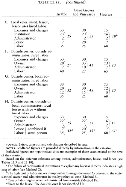
| |||||||||||||||||||||||||||||||||||||||||||||||||||||||||||||||||||||||||||||||||||||
3
Besides their crops, the vecinos raised a large number of animals in the extensive pastures of the Sierra Morena. Herds of sheep and goats roamed the hills, and the vecinos also kept many pigs, which they destined for sale or slaughter. The main source of meat for the town was its goats, of
| ||||||||||||||||||||||||||||||||||||
| |||||||||||||||||||||||||||||||||||||||||||||||||||||||||||||||||
which the butcher sold seven hundred per year.[30] Table 11.14 calculates the income from raising animals, following the method established previously.[31] It indicates an annual return of 3,840 EFW
Another product of the sierra was honey. The catastro records 4,371 beehives, 3,900 owned by vecinos, 471 by outsiders.[32] At 6 reales per
[30] Baños, resp. gen. Q 29.
[31] See Appendix K.
[32] Baños, libros maestros.
year each, the locally owned hives provided the town with 23,400 reales, 1,670 EFW.
Finally, the catastro mentions a number of minor animal and vegetable products for which no specific amounts can be derived. They include flax, hemp, and silk. A tithe known as minucias was levied on these products as well as newborn animals, wool, cheese, honey, fruits, and "other seeds." The collection of the minucias was farmed for 9,000 reales, indicating an annual product of some 100,000 reales on all the items it covered.[33] Our total for fruits, vegetables, verdes (Table 11.4), 17,195 reales; animals (including wool and cheese, Table 11.14), 53,759 reales; and honey, 23,400 reales, is 94,354 reales. This would leave about 5,600 reales for flax, hemp, and silk, 400 EFW. The calculation is very uncertain, but the result is worth including in our accounting.
Beyond its agriculture and livestock, the activities of Baños could add very little to the town income. The number of artisans was small, and most must have lived off the trade of the town. There were three blacksmiths, with four journeymen (oficiales ); possibly they also served the town of Bailén to the south, which had only one blacksmith.[34] Their total income was about forty-five hundred reales; let us assume that fifteen hundred came from Bailén, approximately 110 EFW. The town had seven shoemakers, but only three shops. Yet they probably had all their business in the town, for surrounding towns also had numerous shoemakers.
The only other clear source of income was the two inns located on the main Madrid-Andalusia highway. The smaller one belonged to the Duque de Arcos, a nonresident; the larger one was the property of the town council, which rented it for 14,300 reales per year. The men who rented and ran the two inns had a net income of 12,100 reales between them.[35] This gives a total gross income of 26,400 reales for the town and its vecinos, but some of the supplies—wine, bread, meat, some condiments—were town products and represent a form of export that should not be counted twice. Most eighteenth-century travelers in Spain carried their own food and supplies, however, so that the major charges of the inns were for services. Let us estimate a net income of 20,000 reales, approximately 1,430 EFW. It is true that vecinos would have accounted for some income of the inns, but their expenditures can be offset against
[33] Baños, resp. gen. Q 15, describes the minucias. It does not mention kids or honey, but the minucias of Lopera included both (Lopera, resp. gen. Q 16), and so surely did those of Baños, since they were major products. On farming the minucias, see Baños, resp. gen. Q 16.
[34] AHN, Hac., libro 7452, letra G. The blacksmiths earned 6 reales a day, the oficiales, 2. I assume 180 days worked per year.
[35] Baños, resp. gen. Q 17 and maest. segl., ff. 49, 157.
the net gain of a third inn, located in the town itself, where outsiders would have spent sums not included in our figures.
In order to draw up the balance sheet of the town economy, we now need only the charges levied on it, primarily the tithes and royal taxes. The catastro is anything but clear on the disposition of the tithes and other religious levies.[36] The tithes were divided between two funds called barraño and pila, but the catastro does not define them. The collection of the barraño was farmed for seven thousand reales, that on olive oil and wine for thirteen thousand reales, suggesting that barraño was the tithe on grains and minor products, the pila on oil and wine. The barraño went to the bishop and cathedral chapter of Baeza, 500 EFW leaving the town. The pila was divided among the Congregation of San Felipe Neri of Baeza (owner of the préstamo canongible ), various benefices in Baeza, the king (tercias reales), the local fabric, the local clergy, and "one-eighth for the expenses of works" (gastos de obras ). The catastro does not state the share of each. Lacking better information, we can break the pila down as in Table 11.15, indicating that of it 587 EFW left the town. The Voto de Santiago amounted to 30 EFW, also destined elsewhere. Two minor ecclesiastical levies, the pie de altar on hortalizas (products of the huertas), rented for five hundred reales, and the first fruits (thirty fanegas of wheat and fifteen of barley) were kept by the local church and clergy. The destiny of the tithes on minucias is not stated; it rented for nine thousand reales. Between préstamo and tercias reales, probably five-ninths of it went to outside destinations: 357 EFW. The best estimate of the total ecclesiastical levies leaving the town is therefore 1,474 EFW. In addition, part of the income of the parish church would be spent outside the community; as for earlier towns this share is estimated at one-fourth.[37]
Royal taxes are more clearly expressed, for they were paid directly by the town council. Table 11.16 shows they were 1,626 EFW. The town owed two censos, one for seven thousand ducats to a vecino of Anduj ar, and another for forty-five hundred ducats to a vecino of Jaén. At 3-percent interest, the town paid annually 2,310 and 1,485 reales, or 271 EFW.[38]
We can now total the annual production, the income from outside,
[36] Baños, resp. gen. QQ 15, 16.
[37] The income in question is that of the fabric, confraternities, and charitable endowments. Capellanías and other income assigned to individual clergymen are excluded. From its properties, the church received the income stipulated in Table 11.11, with 10 percent deducted for administration: very close to 14,000 reales or 1,000 EFW. 250 EFW is thus the amount leaving the town economy.
[38] Baños, resp. gen. Q 26.
| ||||||||||||||||||||||||||||||||||||||||||
| ||||||||||||||||||||||
and the outside payments of Baños (Table 11.17). The net town income is 19,020 EFW. When divided by the best estimate of the total population, 1,830 people, this sum gives a per capita income of 10.4 EFW. This figure is of course an approximation. I have based the harvests on the reported tithes, with a result well below the prediction from the extent
| ||||||||||||||||||||||||||||||||||||||||||||||||||||||||||||||||||||
of the different qualities of land recorded in the catastro, especially in the case of olive oil. The catastro indicates 40 percent more olive oil than the tithes, a difference of 4,300 EFW, and also 700 EFW more in grain. These additions would give a town income of close to 24,000 EFW, enough for each inhabitant to have 13.1 EFW. But this is an outside figure, and the truth probably lies closer to the original estimate. A town of this size probably could cheat on the tithe collectors (who were not clergymen but tithe farmers), but it is hardly likely that close to a third of the olive oil could escape their noses. If one-tenth of the oil and grains were hidden, the total would be 20,700 EFW, and the per capita income 11.3. Let us accept momentarily a figure between 10.4 and 11.3, under the 12 EFW threshold of well-being, but leave the question open for reconsideration. This figure is below that of La Mata and Villaverde on the plains of La Armuña but above the level of the sierra town of El Mirón.
4
How this income was spread among the vecinos determined the economic position of the different sectors. Unfortunately we lack the tithe payments of individual heads of household, which were the basis for much of our knowledge of the social structure of the towns of Salamanca. Since the collection of tithes was farmed out to private individuals, it is unlikely that the religious authorities ever received a report on each vecino's payments or that they have been preserved elsewhere. One must proceed solely on the information furnished by the catastro. Except for the few properties that the religious institutions rented, it tells us nothing about who actually farmed the land, only who owned it. But we can assume that local owners who used hired labor nevertheless administered their own properties, and from the social structure one can guess with fair assurance who actually labored in the fields and who paid others to do so. All we lack is the names of the lessees of properties of nonresident laymen, and in the total picture this information is not of major significance.
Table 11.11 on the division of the harvests and the information in the catastro on other activities make possible an approximation of the total income of the various heads of household. For each owner of land, buildings, and animals, one must decide whether he worked his land and tended his flocks himself or used hired labor (either mozos who lived in his house or jornaleros). Those whom I assume to use hired
labor and receive the corresponding share of the harvest (Method B) are labradores titled don, clergymen, boys under tutelage, widows titled doña, and other ferrale heads of household except widows with one or more sons over eighteen living at home. All others are considered to work their properties themselves or with the mozos listed in their households.
Since local administrators are identified, their income is calculated according to the proper category (Method C, D, E, G, or H). We do not know which lands of outside owners under the care of any specific administra tor were farmed directly and which were leased, but we have estimated how much of each kind of land owned by outsiders was leased and can thus calculate the total amount of administrative costs and prorate it among the individuals according to the income from the lands they oversaw.[39] Neither do we know the names of the individual lessees of properties of outtsiders, but their total share, 232 EFW, is divided among the larger labradores, as the most likely group among whom to find the lessees.
The income of agricultural laborers must also be determined. The provincial summary of the catastro attributes to Baños 126 labradores and their sons and hired hands ("labradores inclusos hijos y mozos") and 336 jornaleros.[40] This is a total of 462 adult males employed in agriculture, but it is not clear how the drafters of the catastro assigned specific individuals to each group or got these totals, for the household lists of the town do not obviously produce these figures.[41] Table 11.18 indicates one possible reconciliation of the two sources. To arrive even near the total number of males working in agriculture recorded in the provincial summary, all sons of shopkeepers, muleteers, and artisans (except two sons of farriers said to work with their fathers) have to be considered to earn their livelihood in the fields or as herders.
To all men engaged in agriculture, the catastro assigns indiscriminately an income from their labor of three reales per day. It does not say how many days per year they worked, nor does any catastro from a town in Jaén province give this information. In La Mata, the figure was 120 days; in Villaverde and El Mirón, 180. Applying these two numbers to Baños would give the individuals 25.7 or 38.6 EFW return for their labor. The information in Table 11.11 permits a rough check on these
[39] By interpolation, the administrators' share for Methods G and H comes to: arable: 5 percent; olive groves and vineyards, 1 percent; huertas, 2 percent.
[40] AHN, Hac., libro 7452, letra G.
[41] Baños, personal de legos; personal de eclesiásticos.
| ||||||||||||||||||||||||||||||||||||||||||||||||||||||||||||||||||||||||||||||||||||||||||||||||||||||||||||
| ||||||||||||||||||||||||||||||||||||||||||||||||||||
estimates, for it tells us what proportion of each harvest went for the cost of labor. Table 11.19 spells out this return, a total of 5,761 EFW. Divided among the men engaged in agriculture (omitting the animal herders, the total is 414), this amount indicates a per capita share of 13.9 EFW, hardly half of the minimum estimate above.
It is virtually impossible that each member of this group could have earned even the minimum estima te, 26 EFW, from laboring in the fields, for in order to reach this figure over 50 percent of the product of the soil and beehives would have had to go to labor. Yet we are told that 25 percent was the share of the owner, and we have calculated that the charges for seed, tools, animals, and tithes range from 15 to 33 percent, and one must allow a proper share to the lessees.
The average family of a jornalero had between three and four members (Table 11.20). Even though all reports were that Andalusian laborers lived on pitifully little, 14 EFW, derived from the share of the harvests attributed to labor, equal to a return on sixty days' work, cannot be considered adequate for these families. The women and children worked, especially at the harvest of grain and olives, but their wages would have to come out of the share marked for labor, reducing that here assigned to the men, not increasing the total family income.
Where else could they turn? The most obvious answer is the extensive término privativo, whose use according to the royal grant was open
| |||||||||||||||||||||||||||||||||||||||||||||||||||||||||||||||||||||||||||||||||||||||||||||||||||||||||||||||||||||||||||||||||||||||||||||||||||||||||||||||||||||||||||||||||||||||||||||||||||||||||||||
| |||||||||||||||||||||||||||||||||||||||||||||||||||||||||||||||||||||||||||||||||||||||||||||||||||||||||||||||||||||||||||||||||||||||||||||||||||||||||||||||||||||||||||||||||||||||||||||||||||||||||||||||||||||||||||||||||||
| |||||||||||||||||||||||||||||||||||||||||||||||||||||||||||||||||||||||||||||||||||||||||||||||||||||||||||||||||||||||||||||||||||||||||||||||||||||||||||||||||
to every vecino. Strangely, only one-tenth of the area available for slash-and-burn (roza de cama) was cultivated, yet only fifty-three of the jornaleros, one-quarter of the total, tilled even modest plots here, and of these all but four owned some land or animals. Of eighty-three labradores with no property, only these four made use of the término privativo. By comparison, eleven of the fifteen labradores and labradores pegujaleros exploited it, and three of the six labradores titled don had large tracts in it. Were the poorest jornaleros systematically discouraged from taking their share? Could they not afford the seed or necessary tools and use of animals?
The answer to both questions might be yes, and still another reason be more important. The jornaleros might find work outside the town limits. Migrant labor is a well-known phenomenon in twentieth-century Andalusia, and it has existed for centuries. Several towns in Jaén province enacted rules in the sixteenth century to control the temporary exodus of their harvest workers.[42] By chance, evidence for it in our period appears in the catastro of the small town of Tobaruela, a bare fifteen kilometers southeast of Baños. To the question "How many jornaleros are there in the town, and how much is their daily wage?" the reply was "There are no jornaleros, and those who come from outside to work for short periods are usually paid three reales daily."[43] In addition, indirect evidence of the use of migrant labor will appear in Lopera, the next town to be observed. Both Tobaruela and Lopera were near the Guadalquivir River. Baños, a sierra town, could well have been one of their suppliers. For the jornaleros of Baños, walking to places a few hours, or at most a day, away could be more attractive than struggling with virgin soil in the hills and the possible displeasure of their betters, the dispensers of local employment.
How much did they make this way? At this stage of our information, we do not know the pool of migrant laborers or the extent of the demand. But jornaleros could not labor in two places at once, so that the question is partly how much earlier the various agricultural tasks, especially the harvest, were performed in the valley than in the sierra. If the seasons overlapped by half, the workers might have gotten another thirty days' labor, and this can be used as an approximation. If each brought home 80 percent of his earnings, this would mean about 5 EFW more per year, giving each a total of about 20 EFW. This, rather than 14
[42] Vassberg, Land and Society, 195.
[43] Tobaruela, resp. gen. Q 35, in AGS, Dirección General de Rentas, Única Contribución, libro 327, f. 1.
Figure 11.3.
Baños, Socioeconomic Pyramid, 1752
NOTE : In Baños and Lopera the complexity of the structure calls for more
levels than elsewhere. Note that the top level was substantial and had very
wide economic limits. This is a bar graph based on Table 11.20, with an
indication of dispersion. It is not a set of frequency distributions.
EFW, will be considered the individual income from agricultural labor, whether migrant or not. The outside income of the migrants, of course, is an addition to the total town income not previously noted and should be included in Table 11.17. Two hundred thirty-seven jornaleros and working dependents (Table 11.18) would bring in another 1,200 EFW and raise the per capita town income to between 11 and 12 EFW.
For the rest of the households, the calculations are more complex than for the smaller towns of Salamanca, but the results can be tabulated in a similar socioeconomic pyramid, although with more occupations and levels (Table 11.20 and Figure 11.3). The groups are arranged according to income and, secondarily, ascribed criteria like the appellations don and doña and callings that would attribute respect like labrador and municipal officials. The result is a pyramid of seven strata, ranging from hidalgos, priests, and professionals entitled to the don or doña, at the top, to propertyless widows and indigents at the bottom.
The stratified social structure of the town jumps at one from the table
and figure. Forty families formed the top level. Above all the others was the widow doña Francisca Luisa de Molina de la Zerda y Soriano, who lived in her house facing on the town square with her three maidservants and the twenty-five men servants she employed to till her extensive fields, olive groves, and huertas (most of them tied up in six vínculos that had fallen to her lot), tend her fourteen hundred goats and one thousand sheep, and run her cortijo and oil mill. Her net income was some 1,800 EFW, six times that of the wealthiest labrador we found in Salamanca. Next to her came the hidalgo labrador don Francisco Manuel Zambrana y Rivera, with 950 EFW, and the prior of the parish church, the licenciado don Francisco Charidad Villalobos, with 940 EFW, 400 from his ecclesiastical emoluments and the rest from his private estate. Two priests with net gross incomes of 60 EFW and two dons (hidalgos I would guess), whose only recorded receipts were 9 and 28 EFW, made up the bottom of these forty households.
They fell into two distinct groups, those that belonged to the landowning class and those that owed their position to their professional or clerical status. All were called don or doña. Although this attribute is no guarantee that they were hidalgos,[44] it is more than likely that the landowners had their patents of nobility. If they did not, they might as well have; no one was likely to pry into the question. The landowners included seven men, two widows, and a single woman; each possessed lands producing over 100 EFW for their owners. Four of the men were regidores perpetuos (surely hidalgos), the others were an "official" of the town council, the town recorder (fiel ejecutor ), and the alguacil mayor of the Inquisition. These positions paid no money, but they formed the major portion of the municipal government or represented the disciplinary role of the church. With them can be grouped four members of the clergy who owned private lands worth 100 EFW or more: the prior, two other priests, and a man in minor orders, while the other in minor orders had land worth 60 EFW. Their family names show that many of these individuals belonged to small dynasties. Don Francisco Charidad Villalobos was the prior; don Diego Charidad Villalobos was a regidor. Molina de la Zerda was the family name not only of the wealthy widow but of the alguacil of the Inquisition, of one of the clerics in minor orders, and of the two single women called doña. Don Josef Galindo y Soriano was fiel ejecutor and don Francisco Galindo y Soriano the other cleric in minor orders (he also had a house on the town square).
[44] See the discussion of this subject in Chapter 15, section 4.
These three families formed the aristocracy of the town. Close beneath them were three others. The del Marmols were less wealthy but very much part of the upper crust. Don Francisco del Marmol Navarro (with an income over 100 EFW) was a regidor and an alcalde ordinario as well, while don Pedro Andrés del Marmol was a priest. The bachelor don Juan Benito del Marmol Galindo (recorded income only 41 EFW) was the fifth regidor and related through his mother to the Galindo family. The Navarro clan belonged here too; besides being related to the del Marmols through marriage, they had a priest, a widow, and a nonresident owner, native of Baños, now living in Baeza, episcopal see of this region.[45] The third family was the Zambrana. Doña Leonor de Bargas y Zambrana, with 400 EFW rolling in annually, was the richest single doña; don Francisco Manuel Zambrana y Rivera was a labrador, second in the town in income, town official, and administrator of the properties of doña Cathalina Thomasa de Zambrana, who lived nearby in Linares. Don Francisco de Zambrana, another of the family, was temporarily classed among the nonresidents; he was in prison in Granada, for reasons not elucidated. Only three persons among the wealthy hidalgos and clergymen had family names not shared with others: Pérez de Bargas and Pérez Carrasco were regidores (and perhaps related, as the first was probably to doña Leonor de Bargas), and an Espinosa was an independently wealthy priest.
Forming a second level were the less wealthy clergy and those professionals honored with the attribute don. The latter included the notary, the surgeon, the doctor, the apothecaries, and the administrator of the royal tobacco monopoly. Perhaps the don was in some cases evidence of hidalguía, but most likely it was an attribute accorded their profession, as it was for members of the clergy. Among them, only the notary owned land, and his returned a mere 32 EFW per year, but their professional incomes ranged from 80 to 315 EFW. The less wealthy clerics owned more private property than these men; all but one had land in Baños producing for him over 20 EFW. Among these men one found another distinguished local family, the de Lechuga, which included the notary don Thomás and the curate don Antonio Joséph. Don Thomás, in addition to 30 ducats' income from his notarial office (330 reales, 24 EFW), received 100 ducats from the cabildo and 150 ducats from the crown for handling the alcabalas and millones taxes. His total income was 316 EFW. The priests' benefice was worth 76 EFW, and he had property that
[45] Baños, maest. segl., no. 367.
produced 66 more for him. The de Lechuga family might well be hidalgo, part of the local oligarchy. Indeed, the notary's matronymic surname was Galindo, indicating ties with one of the wealthiest landed clans.
To them who have shall be given. The persons chosen by nonresident owners to administer their properties in Baños were mostly of this top level. Priests, already stewards of the ecclesiastical properties in the town as well as their own, were preferred. Nine of them received 270 EFW in fees from outsiders (according to the rates calculated in Table 11.11). Of the remaining 84 EFW paid for administration, 48 went to two hidalgo labradores. One can expect that among these people were to be found most of the lessees of land of absentee owners, whose identity the catastro does not provide. To their income one should then add one attributed to lessees. No doubt some of them also had properties beyond the town limits, but unless these lands surpassed those owned by nearby vecinos in Baños, they supplemented only marginally the income of this level.
This top level, despite the wide range and different sources of their individual incomes, formed a unified group that dominated the town economically, politically, and through the church, culturally. The priests clearly belonged to this elite, both by economic status and by family ties. Priesthood in Baños was not a calling for sons of modest families. José María Blanco, a contemporary native of Seville, who later as a priest became notorious by fleeing to England during the Napoleonic conquest of Spain and abandoning his Catholic faith, complained that Spaniards who entered the clergy were divided by social class. The poor usually entered the regular orders, while the sons of the gentry became secular clergymen.[46] His observation could not be generalized to include northern Spain, where many priests were of very humble origins,[47] but Baños demonstrates its cogency for Andalusia. None of its priests came from the lower sectors of society, although their benefices were ample to support an individual without income of his own. The smallest provided 16 EFW; it was held by a man independently wealthy. The benefices could have been used to enable sons of modest families to become priests, but the elite of Baños had managed to fill them with their own kind and kin, using the church to harden social distinctions. Even if a man of modest means had broken through the barrier erected by the elite, he would have run into trouble. Before he could take over his bene-
[46] María Blanco y Crespo, Letters from Spain, 82, Letter 3.
[47] See Herr, "Comentario," 276.
fice, he might have to guarantee his administration of its properties with a lien on estates of his own.[48]
The town square, lying in the shadow of the old Moorish castle, made the power of the elite apparent to the world. Facing the castle was the parish church, and along one side the house of the town council, both safely in its control. Opposite these edifices were the houses of three of the wealthiest of the town notables, two priests and the widow doña Francisca, representing the three dominant families. The square could not accommodate the residences of all members of the elite, nor could such people all afford to vie with the Molina de la Zerda, the Charidad Villalobos, and the Galindo y Soriano families. But even the modest hidalgos and priests were members of the notability, set off by the distinction of the don, above the commoners of the community.
The pecheros, the commoners, fell into six strata beneath them. The highest stratum was one of almost thirty households, devoted to occupations whose members averaged over 100 EFW income. They were the storekeepers, the innkeepers, the labradores, the leading public officials, and the most highly rewarded artisans: the farriers and the bakers. The innkeeper of the Venta de Miranda had a net income of 740, placing him third in the town, although his business, way off in the sierra, would not have permitted him to parade frequently in the main square. In this level belonged the three men with official positions who were not of the notability: the inspector of butchershops (fiel de carnicerías ), who was also the schoolmaster; the inspector of oil measures and the tax on outside tradesmen (fiel medidor de aceite y alcavala del viento ); and the second alcalde ordinario. In this level without question the most prestigious, although not the most wealthy, were the five labradores. They belonged to only three families; for two were named Muñoz Galindo and two Barrionuebo. A third Muñoz Galindo, the widower Pedro, was the second alcalde ordinario, chosen no doubt as a representative of this select group of commoners. (The catastro even calls him don when listing him with the other public officials.)[49]
The matronymic surname of this family suggests relationship with the powerful Galindos. They were unique; none of the others of this level shared a surname with the hidalgos and other notables (except for the frequent one Ruiz). Intermarriage between hidalgos and pecheros, even wealthy ones, was virtually unknown. One begins to see why there
[48] AHPJ, Contaduría, libro 4426 (7 July 1801), ff. 6v–7r. The curate of the parish of Baños obtains a capellanía upon promising to care for its properties and providing an "hipoteca" on ruedo land worth 15,000 reales.
[49] Baños, resp. gen., intro. f. 1v. He appears without "don" in the libro personal de legos and the maest. segl.
were six wealthy spinsters of hidalgo status. Yet even if the commoners were kept at a distance by their social betters, many of them could rival the notability in income. They had the means, like the ruling sector, to amass a peculium for a favorable opportunity.
Below the top commoners came two strata whose incomes were moderate but adequate. The first included most of the master artisans, the muleteers, the servants of the parish church (sacristan, organist, and subchanter), all with mean incomes between 50 and 100 EFW. Here too I place those men who for one reason or another could not work but did not need to because of their private incomes, no doubt a condition that gave them a certain prestige among the commoners. Members of this stratum could live comfortably, but except for a couple of muleteers, they could not match the wealthy commoners and notables. The position of the master artisans was considerably better, both in absolute terms and relative to their fellow vecinos, than that of the artisans of the towns of Salamanca. Pierre Vilar has shown that the catastro reveals this contrast to be general between northern and southern Spain. In the north artisans worked alone; in the south they were heads of small shops, and Vilar found that the income of the latter was higher as a result. In the south the artisans, as a general rule, were better off than the agricultural classes (except the landowning elite); in the north the opposite was true.[50] Baños supports this generalization. Although farriers, carpenters, and a wineskin maker worked alone, the shoemakers, tailor, saddlemaker, blacksmiths, and masons each had one or more journeymen helpers (oficiales).[51] Theirs were establishments open to the public, perhaps with shops on the street, different from the cottage work found in our Salamanca towns. Just as the whole social structure was more complex in Baños, so was that of its crafts.
The second of these two strata, third of the commoners, was headed by the farmers who could not qualify as true labradores, known familiarly as peujareros, or pegujaleros in correct spelling, and the garden farmers, the hortelanos. Here too were the animal herders (who had their own flocks to supplement their wages), the miller (did he get unlisted gratuities from his clients?), the barbers, and the lesser artisans, such as the pitchfork maker and soapmakers. Their incomes were marginal, between 30 and 60 EFW, but most managed to live adequately by restricting the size of their families. Here too I place the twenty-five single women of common status. Although their incomes were low (mean 21), they had few dependents and as a group enjoyed adequate
[50] Vilar, "Structures de la société espagnole," 425–47.
[51] Baños, resp. gen. Q 33, personal de legos.
income for their needs. If a spinster maintained her own household, it was because she had the wherewithal to do so, and almost half of them even had the service of a maid.
We come now to the levels of people who failed to earn enough to support their families adequately, and the lowest of whom lived in poverty. Altogether they were 301 households, three-fifths of those in Baños. The largest stratum, 183 families, was made up of jornaleros who had some animals or property (perhaps just the house they lived in), and the families headed by widows with property. If the latter included males old enough to earn the wages of a jornalero, they could be well-off: as a group (and there were 25 of them), their per capita income approached the 12 EFW threshold. For the other widows with property and the jornaleros with property, the per capita income averaged around 9 EFW, which is what we found among the poorer families in the sierra town of El Mirón. Finally, I place here a few men who served the public in semi-official ways. The three "ministros ordinarios" were presumably servants of the city council; the hermitaños took care of the chapels outside the town limits. Even attributing to them the income of a day laborer, their income was inadequate; but it is not hard to imagine, given their function and the society in which they lived, that gratuities frequently greased their palms. They would not have been at the bottom of the pile.
Those that were at the bottom were propertyless widows and jornaleros. The day laborers and the widows with working sons had income we can detect (we saw that the average able-bodied male earned some 20 EFW per year, including his labor outside the town limits). Their families were small, but probably larger than the catastro and Table 11.20 say, because one recalls that the libro personal de legos appears to omit some fifty females, most of whom would have been in households in the bottom strata. These families could have obtained hardly half the 12 EFW per capita that I have judged adequate. And even this still left almost 5 percent of the households with no recorded income at all, the widows without adult sons, the old, the halt. Odd jobs and charity must have maintained them, but here were the miserable creatures that impressed the contemporaries who visited Andalusia. These lower levels were almost a quarter of the families in the town. And here too I place the three families of Gypsies, living by their labor and their wits but ostracized by those who were economically their peers.[52]
[52] See Sánchez Ortega, Gitanos españoles, and Sanchez Ortega, Documentación selecta.
The picture that emerges is of an economy and society strikingly different from the towns of Salamanca. The peasants of La Mata, Villaverde, and El Mirón lived together in nucleated villages with less social ranking than economic differentiation. The priests stood out, as did the notary of El Mirón, but the class of large landowners who controlled the arable fields of La Armuña and the cotos redondos like Pedrollén—the beneficed priests of the cathedral and parishes of Salamanca, the city officials, and the titled nobles who lived as far away as Madrid—although of the same ilk as the priests, hidalgos, and other notables of Baños, lived far away and were invisible. The peasants of La Armuña were exploited from outside; they did not face an omnipresent class of poderosos to inculcate them with a sense of ignorance, poverty, and inferiority. In a sierra town like El Mirón, most of the outside owners were nearby labradores like themselves. Of course, no one who lived in Spain then or is familiar with its history would find anything new in this contrast between north and south, but generalizations gain from direct illustration.
Baños was the image of the social order of the old regime, based on caste and the exploitation of human labor in traditional ways. Its elite belonged to the familiar privileged orders, hidalguía and priesthood, united by family ties and closed against intermarriage with the pecheros. Members of the elite dominated the land, the church, and the local government. Not all may have been legal hidalgos, but all shared the traditional distinction of that order, the title don. Notables is a suitable term for them. More or less on a par with them economically but separated by a social chasm were the most select commoners, mainly labradores and merchants, middle classes if one wishes but of a very traditional kind, no different from those present two or three hundred years before. Far below were the day laborers and widows living in poverty. In between was the middle range of pecheros, most artisans, the muleteers, the small farmers and market gardeners. Basically this was an agrarian economy, with those who controlled the land at the top, those who labored on it at the bottom, and in between the secondary and tertiary sectors.
5
In 1767 Carlos III created the colonies of Sierra Morena along the Madrid-Andalusia highway.[53] In so doing he took a large section of the ter-
[53] See above, Chapter 1, section 6.
Figure 11.4.
Baños, Population Structure, 1786
NOTE : Since there is no limit to the top age group, a span
of seventeen years is used for convenience only.
ritory of Baños and assigned it to the new towns. Baños lost some pastures, part of the término privativo with several cortijos; the inn of Miranda, deep in the sierra; and the smaller one at Guadarromán, which became the center of the new town Guarromán. The inns were a blow; they represented 7 percent of the total town income. But the heart of its término was not affected, and the residents of the nucleus would have suffered little.
There is no other direct information on the evolution of Baños between the catastro and the beginning of desamortización. The census of 1786 is of little use, for it appears inaccurate. It shows a population of 1,754, hardly more than in 1752. But these are 924 females and only 830 males, whereas the catastro specified 836 females and 943 males (see Figure 11.4). Any attempt to reconcile these two counts and establish an upward or downward population trend becomes too conjectural to have any significance.[54] Even Miñano's return for 1826 is of little
[54] For the 1786 census of Baños, see Appendix N, Table N.6.
help, for he gives two counts of total inhabitants: 1,898 and a revised one on the basis of a letter from a vecino of the town, 2,638. The first would indicate almost no growth since 1752, the second 44 percent, hardly likely.
The census of 1786 records 50 labradores and 228 jornaleros; the figures in 1752 were 15 and 199. Without knowing how the census taker defined his terms, we cannot establish any change in status. The number of hidalgos in 1786 is 3; there were 6 labradores called don in 1752, which I take to be the minimum number of hidalgos at that time. One is left with nothing solid to go on to establish the evolution of the community.
Some reasonable conjectures can nevertheless be ventured. As throughout Spain, the price of agricultural products rose. Whereas wheat was selling for fourteen reales a fanega in 1752 and olive oil for fourteen or fifteen the arroba, by the 1790s the average prices in Jaén had risen to about forty-seven and fifty-two respectively.[55] Price inflation would have meant downward pressure on real agricultural wages, bringing additional hardship to jornaleros and benefit to those who exploited the land.
Within the limits imposed by the inflexible social barriers, inflation favored social and economic mobility, for the land was relatively free from entail. Besides the 7.4 percent belonging to the municipal council and 13.9 to ecclesiastical institutions (Table 11.7), 10.3 percent was incorporated in local vínculos and 3.8 percent in outside vínculos.[56] This gives a total of 35.4 percent in entail, and means that almost two-thirds of the land could be bought and sold without legal impediment. A major pressure for change appears to have been the attraction for outsiders of the rich and easily exploited olive groves, which produced the most important harvest of the town. At midcentury 86 percent of the property of outsiders was in olive groves, and they controlled one-third of them. But as yet no forastero dominated the economy. The most important, doña Isabel Mária Ponce de León of Granada and don Antonio Balenzuela, a minor residing in Andujar, had properties in Baños that brought them 316 and 213 EFW respectively, well below the largest local holdings.[57] The contaduría de hipotecas shows active buying and
[55] 1752 prices from Baños, resp. gen. Q 14, and Lopera, resp. gen. Q 14 (see Chapter 12). Wheat price the same; oil, 14 in Baños, 15 in Lopera. 1790s prices from Anes, Crisis, Graphs 54 and 70.
[56] Based on the value of properties listed as vínculos in Baños, maest. segl. The figures may not be accurate, for the catastro is not clear on what lands were included in vínculos.
[57] Baños, maest. segl., nos. 370 and 379.
selling of property going on among the vecinos, but even an exhaustive study of extant notarial records would probably not tell us how much land changed hands. Much less land would have changed stratum; the overall property structure could hardly have been altered significantly by the end of the century.
Sales of ecclesiastical property under the royal decrees of September 1798 began in Baños at the end of 1799.[58] Records exist of 105 sales and the redemption of two censos.[59] Much of the activity took place early on; 36 sales were recorded in 1800 alone. The commissioners appear to have followed the official instructions, at least at first. Separate appraisers assessed the property for the crown and the owner; posters and the public crier announced the auctions. The authorities observed the prescribed delay after the auction to permit someone to raise the closing bid by 25 percent, then the provincial commissioner of the Amortization or Consolidation Fund and the intendant approved the sale.[60] As time progressed, the process was shortened. Thus in 1806 the crown announced the sale of the properties of the hospital of Baños, but they were not appraised nor an auction scheduled until someone made a firm offer on one item. It was then assessed, and an opening bid accepted for the lowest figure allowed. Thereafter the sale proceeded as before.[61] Most sales went for the first offer; only occasionally was there active bidding. All but two purchases were paid for at once. One buyer spread his payments over two years, another over three, putting up other property to guarantee fulfillment.[62]
In two-thirds of the cases I have identified the disentailed properties from their description in the catastro. The unidentified sales could be lands that the church had acquired since 1752 or they could have had their use changed—arable fields that had since been planted in olives, for example—or they could have belonged to the church in 1752 and not been recorded in the catastro. One suspects that all three explanations are involved. Some new endowments had been founded, and property added to others. The New Hospital for the Poor of Baños was not
[58] The first sale recorded by the contaduría de hipotecas at Linares was on 27 Oct. 1799 (AHPJ, Contaduría, libro 4425 [1799], f. 9r), and the last was concluded in May 1807 (libro 4426 [1807], f. 14r).
[59] One hundred sales recorded in AHPJ, Contaduría, La Carolina, libros 4425, 4426 (the record was actually signed in Linares); five sales recorded in Madrid and not in the contaduría (C3009, C21525, C26150, C38636, C51549, C54484); and two censos redimidos (C38567, C59293).
[60] See AHPJ, Contaduría, libro 4425 (1799), f. 14r; libro 4426 (1800), f. 3v.
[61] See ibid., libro 4426 (1806), f. 13r.
[62] Ibid., libro 4426 (1802), f. 10v; (1805), f. 3r.
| ||||||||||||||||||||||||||||||||||||||||||||||||||||||||||||||||||||||||||||||||||||||||||||||||||||||||||||||||
in existence in 1752. One of the priests then alive appears to have founded it and endowed it, but others added to it, in the spirit of useful charity of the century, for the crown sold off three times as much property belonging to it as the founding priest had owned.
The continual buying and selling among private individuals and the unidentified lands that were disentailed make it impossible to establish the property structure in 1808 from the one revealed by the catastro, but one can say how much of the land in Baños changed hands through disentail, for we have the catastral value of identified lands and can project values to the others.[63] Only arable land and olive groves were disentailed (Table 11.21). Altogether 9.2 percent of the land, by value, changed hands; if the municipal pastures and término privativo are not included
[63] Since the ratios of sale price to catastral value for sales to vecinos were distinctly lower than those to outsiders, I used two sets of ratios of sale price to catastral values. For purchases by vecinos, paid in efectivo: arable 21 : 1, olive groves 31 : 1; paid in vales reales: arable 26 : 1, olive groves 39 : 1. For purchases by outsiders, in efectivo: arable (no cases), olive groves 35 : 1; in vales reales: arable 32 : 1, olive groves 46 : 1.
| ||||||||||||||||||||||||||||||||||||||||||||||||||||||||||||||||||
in the base (many of them had been lost to the new colonies of Sierra Morena), the proportion becomes 9.9 percent—one-tenth of the cultivated land.
The effect on the church can be surmised by a comparison of the lands sold that can be identified with the amount owned at the time of the catastro. This comparison assumes that all the unidentified properties, a third of the sales, had been acquired by ecclesiastical institutions since 1752. This is an unrealistic assumption, but on the other hand the church would have acquired new properties that were not sold, so that Table 11.22 gives a likely approximation of the difference in its position in 1752 and 1808. The local institutions lost over half their property, and of the highly prized olive groves they lost almost 60 percent. Outside institutions suffered less, for the only one that had property sold was the hospital of Baeza.
Not all local religious funds lost at the same rate, however, for the members of the clergy managed to avoid harm to themselves. Of all the benefices (capellanías) that provided their clerical emoluments, only one had property sold, a house.[64] The clerics evidently had a bastion of defense in their metropolitan see. The order of the crown encouraged the bishops to approve the sale of capellanía properties but gave them the final say. Unlike the Jansenist Bishop Tavira of Salamanca, his peer in Baeza declined the royal invitation. By contrast, the properties of the parish fabric (the building fund) were virtually all sold between 1804 and 1806, although fabric properties were clearly exempted from the
[64] AHPJ, Contaduria, libro 4426 (1804), f. 9r.
royal decree. Evidently the priests of Baños did not object. On the contrary, they personally bought much of the land put on sale (none of the fabric's), which they could exploit and then leave to their worldly heirs. In the matter of temporal goods, blood was thicker than souls.
The total impact of disentail on the town economy was negative, for outsiders bought more than outside churches lost. Since nonresidents were not likely to have added to local foundations since 1752, their acquisitions represented a net loss to the town from the time of the catastro, whether identified in that survey or not. Some of these buyers lived in the colonies of Sierra Morena and their purchases can be treated as local. The others were a resident of Madrid and one of Granada. They went after olive groves, now well established as the predilection of nonresidents. Outsiders had owned 34.7 percent of the olive groves in 1752 (Table 11.7); they purchased 4.4 percent of those in the town but only 0.2 percent of the arable. The town suffered, but not severely: some 150 EFW per year, 0.8 percent of the town income. The loss of the inns on the highway to the new colonies in 1767 had hurt the town almost ten times as much.
Nevertheless the loss was indicative of the evolution of the local economy. A look at the forty-five individual buyers shows why (Table 11.23). The four people at the top of the list bought two-thirds of the land sold and almost three-quarters of the olive groves. Clearly they deserve individual analysis.
The biggest buyer was the señor don Josef Pérez Caballero, a resident of Madrid and member of the royal Council of Hacienda. In his position he may have had inside information on what properties were coming up for sale, but he did not take advantage of the desamortización in Baños until late in 1801, when much had already been sold.[65] For the next four years he dominated the auctions, making bids through his local agent, Juan Josef Villar, and acquiring thirteen lots. He did not only exploit the royal disentail, for during these years he also bought eight lots of olive trees from private individuals, several of whom were forced to sell because of an adverse court decision resulting from the "treacherous death of one of the town's alcaldes."[66] Altogether Pérez Caballero spent 430,000 reales for forty-eight olive groves with 4,799 trees from the church and twenty-one groves with 2,247 trees from private individuals, becoming one of the largest landowners in Baños.[67] He
[65] Ibid. (1801), f. 8v.
[66] Ibid. (1802), f. 36r; (1803) ff. 1r, 2v.
[67] Doña Francisca Luisa de Molina de la Zerda, the largest owner in 1752, had about 6,200 olive trees.
| |||||||||||||||||||||||||||||||||||||||||||||||||||||||||||||||||||||||||||||||||||||||||||||||||||||||||||||||||||||||||||
| ||||||||||||||||||||||||||||||||||||||||||||||||||||||||||||||||||||||||||||||||||||||||||||||||||||||||||||||||||||||||||||||||||||||||||||||||||||||||||||||||||
| ||||||||||||||||||||||||||||||||||||||||||||||||||||||||||||||||||||||||||||||||||||||||||||||||||||||||||||||||||||||||||||||||||||||||||||||||||||||||||||||||||||||||||||||||||||||||||||||||||||||||||||||||||||||||||||||||||||||||||
| ||||||||||||||||||||||||||||||||||||||||||||||||||||||||||||||||||||||||||||||||||||||||||||||||||||||||||||||||||||||||||||||||||||||||||||||||||||||||||||||||||||||||||||||||||||||||||||||||||||||||||||||||||||||||||||||||||||||||||||||||||||||||||||||||||||||||||||||||||||||||||||||||||||||||||||||||||||||||
also bought eight grain fields, two houses, and an oil mill. He leased his grain fields to two vecinos (whom he had beaten out of six olive groves at auction),[68] but he evidently exploited his olive groves directly, as most outside owners did. Villar may have been his administrator as well as his agent at the auctions.
Why Pérez Caballero chose Baños for the site of his investment is not clear. One don Gerímo Ruiz Caballero, a vecino of Jaén, had a modest vínculo and various other properties in Baños in 1752.[69] Were the two related? The dossier of Pérez Caballero's appointment to the Council of Hacienda that would reveal his family connections does not appear in the archives of the council. What the extant records show is that Carlos III gave him a half-time appointment to the council in 1781 in recognition of his accomplishment as intendant of the royal botanical garden in moving it to its present location next to the Prado Museum. In 1788 he received a full position on the council, and in 1792 he retired from the botanical garden.[70] His half salary as a councillor of hacienda was twenty-two thousand reales in 1782, and in addition he had his income from the botanical garden. By the 1790s his salary was close to fifty thousand reales, then equivalent to about one thousand fanegas of wheat, far above the income of almost all residents of Baños. And he may have had other revenues of a private nature. Even after the expense of a presentable home in Madrid, he would have been able to save (although not enough to pay outright for all his purchases; he resorted to loans or had other means).
Baños was not his only choice for investment. In November 1800 his nephew, acting as his agent, bought thirty fanegas of disentailed arable land near Llerena (Extremadura) for seven thousand reales. Pérez Caballero promptly traded this field for one of twice the size but poorer quality belonging to a convent in Llerena, which had the advantage of adjoining an enclosed dehesa that was already his. He then petitioned the royal council to authorize the enclosure of his new field and won approval (in November 1808, in full wartime) despite the protests of the vecinos, who argued that the field had always been leased to them to farm.[71] He was an aggressive agricultural entrepreneur with broad interests across the country, ready to use his official influence to improve his personal fortune. His case shows how money collected by the state and
[68] AHPJ, Contaduría, libro 4426 (1805), ff. 19r, 28v.
[69] Baños, maest. segl., no. 378.
[70] AHN, Consejos, libro 739 (19 June 1781), ff. 43v–45v; (23 Feb. 1788), 299v–300r; libro 740 (23 Mar. 1792), ff. 121r–122r.
[71] AHN, Consejos, legajo 5311.
redistributed to its agents could become the means for individuals located in the cities, and especially Madrid, to extend economic control over the countryside. Olive groves, an easily exploited investment producing a superior commodity in a time of rising prices, were a logical placement for capital. Baños was heavily oriented toward olives, a likely spot for such attention. The church disentail facilitated and accelerated the process, but it would have proceeded without the disentail, for one-third of Pérez Caballero's purchases in Baños were of private properties.
The fourth buyer provides a variation on the theme. Don Fernando Moreno Simón Pontero first appears as a vecino of Madrid. In 1800 he bought eight olive groves in Baños, paying for them with vales reales. Only in the last purchase did he have to overcome the bidding of others.[72] By then he had moved to Real Carolina, capital of the Sierra Morena colonies and next door to Baños. In 1801 and 1802 he bought two houses in Baños, one of them on the town square, spreading his payments over two years.[73] One would like to know if he moved to Baños to care for his olive groves, but we lose track of him after 1802, still in La Carolina. Here was a resident of Madrid who followed his money to the provinces, but we do not know why or where his capital came from.[74]
Acquiring slightly more land than Simón Pontero were two vecinos. Both of them were priests and members of leading families, thus representing a combination of the two strongest groups we found at mid-century. Already in minor orders at the time of the catastro, don Alonso Molina de la Zerda was a scion of the richest family in town. By 1800 he may have enjoyed some of the estates of the opulent widow of 1752, and by then he held one of the best capellanías in the parish, for we have a record of it going to someone else in 1805 after his death.[75] All his purchases came in 1799 and 1800; very possibly his death kept his share from becoming greater. Don Manuel Thomás Orbaneja, the other priest, also made his purchases at the outset, before February 1800. Did he too die? There is no information. The Orbanejas were a lesser family of notables in 1752; don Juan Miguel, a widower, had almost no property, but he was an "official del cabildo [city council]." Don Juan Pedro Alvarez de Orbaneja was then a priest with a modest private fortune. The origin of our Orbaneja is not evident; possibly he was a son of don Juan Miguel and a student in 1752 outside the town. He paid for all his pur-
[72] AHPJ, Contaduría, La Carolina, libro 4426 (1801), f. 2r.
[73] Ibid. (1801), f. 6r; (1802), f. 10v.
[74] His name does not appear in the AHN catalogues, published or unpublished.
[75] Capellanía que fundó Catalina Delgado, Baños, maest. ecles., ff. 56–61; its transfer, AHPJ, Contaduría, libro 4426 (1805), f. 31v.
chases in hard currency, 93,560 reales.[76] Inherited from his mother, perhaps, and accumulated from his benefice.
By comparison with these four, the other buyers were all modest. Yet there is a big difference between the acquisitions of don Blas Josef Muñoz y Galindo—five olive groves with 392 trees and half a fanega of first-class ruedo land[77] —and the five fanegas of don Mariano Eduardo Escalante, part of it fourth class and part monte, good only for grazing.[78] Both buyers came from distinguished local families. Pedro Muñoz Galindo was the commoner alcalde of 1752; Escalante's father was still single at that time and farmed the royal tobacco monopoly.[79] The difference in their purchases shows that even though membership in the notability gave one economic advantages, individual character and conditions determined how much one profited from them. In Escalante's case, he was unfortunate in having two ne'er-do-well brothers who got into legal troubles. To pay their debts the three brothers had to sell their father's estate: ten olive groves, nine fields (one of twenty-six fanegas), and the family house.[80] The buyers of this estate included Muñoz y Galindo and the royal councillor Pérez Caballero. Yet Escalante shook off his brothers and made two purchases of olive groves from private owners as well as buying his five-fanega field of disentailed land.[81] Besides these two, other buyers had names that suggest notability and wealth—del Marmol, Zambrana, the regidor don Pedro Manuel Caridad—and they are scattered from top to bottom of the list.
What is more clear statistically is that one was more likely to be a buyer if one had a claim to the title don, by hidalguía, profession, or clerical position—that is, if one were at the top level of the socioeconomic pyramid. Persons with the attribute don or doña headed 8 percent of the households in 1752 but made up 61 percent of the vecinos who bought disentailed properties. Within the list of buyers, moreover, the dons and doñas monopolize the top; commoners become a majority only in the bottom half. Notability connoted wealth in 1800, as it had in 1752.
The list of buyers reveals other aspects of the local economy. The four large buyers put their money by preference into olive groves, as one would anticipate, because of their ease of exploitation on a large scale
[76] AHPJ, Contaduría, libro 4426 (1800), ff. 5r–7v.
[77] Ibid. (1800), f. 4v; Baños, maest. ecles., no. 29.
[78] AHPJ, Contaduría, libro 4426 (1806), f. 7r; Baños, maest. ecles., no. 21.
[79] Father identified in AHPJ, Contaduría, libro 4426 (1802), f. 37v.
[80] Ibid. (1802), ff. 35r, 37v; (1803), f. 31r; (1805), ff. 1r, 10r.
[81] Ibid. (1805), f. 9r; (1807), f. 13r.
and from a distance. The next ten buyers were more balanced in their choices and in fact showed some preference for arable. Both the parish curate and don Alonso José de Zambrana (a good local name) bought fields but no groves. This level probably consisted of landowners who tilled or administered their own properties and did not want all their eggs in one basket. Such a person was Antonio Peña, the first commoner on the list, very likely a labrador. Beneath this level came the small buyers, who could afford one or, at most, two purchases and usually chose an olive grove.
Except for family names we have little evidence of the wealth of the buyers. However, the contaduría registers from which most of the above information is drawn also tell us something about other sources of income. They record those notarial documents that involve the pledging or transfer of real property, and from them one learns of three activities that many buyers were engaged in: farming church revenues and administering church properties; buying and selling private property; and acting as agents or guarantors (fiadores) for third parties (Table 11.23).
What is striking about the vecinos on the list is the large number, 42 percent, who already exploited ecclesiastical revenues. Some administered church properties (one can assume that the two priests at the top did, although no record of this activity would appear in the contaduría), but many more farmed the collection of tithes, not only in Baños but in nearby towns. This could be a significant source of income. Take the case of Bartolomé Montesinos. In 1800 he and three others obtained the farm for one year of the excusado de la pila of Baños for 30 fanegas of wheat and 262 reales.[82] As part of the joint bond, he pledged his house. Next year he and six others began to farm the excusado de la pila of Baños, Bailén, and Javalquinto (nearby towns) and the minucias de la pila of Baños for a total of 116 fanegas of wheat and 17,750 reales. Montesinos did not put up any collateral.[83] In 1803 he and two others got the farm of the Voto de Santiago for the partido of Arjona (at some distance across the Guadalquivir River) for 510 fanegas of wheat. He put up two houses as guarantee.[84] In 1804 he won for himself the excusado of Jabalquinto, a modest affair, with a house of his wife for bond.[85] Finally he and his wife took on the Voto de Santiago of Arjona and Villacarrillo for 612 fanegas of wheat, pledging his house, 7 fanegas
[82] Ibid. (1800), f. 22r.
[83] Ibid. (1801), f. 5r.
[84] Ibid. (1803), f. 12v.
[85] Ibid. (1804), f. 5r.
of arable and 6 of monte, and a baker's oven.[86] He had acquired the oven in 1805 at auction from the parish fabric, his only purchase of church property.[87] Here was a man with drive—a baker, perhaps, for in 1752 the bakers were among the top of the commoners—who exploited the church revenues to get wealthy. Yet he did not buy land, for his activities were elsewhere. The fabric sold another baker's oven; it went after heavy bidding to Juan Josef Villar and his daughter.[88] Villar was another commoner on the make, the agent who handled Pérez Caballero's purchases. He dabbled in church revenues (putting up as collateral four olive groves and three houses)[89] and bought olive groves from the church and private individuals.[90] Was he too a baker with a small family estate? Quite likely, for he was determined to get his oven.
These cases show directly what the catastro has indicated only indirectly, that church revenues offered possibilities to enterprising individuals. But they were not always a sure thing, nor were they the only such possibility. Don Mariano Escalante, whose father held the tobacco monopoly in 1752, participated with his father, a brother, and seven others in the farm of the oil tithes of Baños, its largest church revenue. At 90,213 reales, they had bid more than it produced and still owed over 3,000 reales in 1800.[91] In 1802 don Mariano was back in tithes, along with Villar, and he also won the bidding for the fiel medidor and correduría of the town.[92] Another loss on tithe farming occurred in 1807, when the parish curate don Thomás Ruiz bought two olive groves from people forced to sell for inability to fulfill their contracts. One of the orchards belonged to Escalante's two brothers, again unsuccessful in their ventures.[93]
On the other hand, commerce was not a major source of wealth behind the purchases. Only one buyer was clearly a merchant, Pedro García, who bought a small olive grove. We do not know whence came the wealth of Simón Pontero, fourth of the top buyers. Otherwise the capital came from landowning and services to church and government, economic and bureaucratic activities of the absolute monarchies of the old regime. The great demand for olive groves of Baños and the eagerness to farm ecclesiastical revenues give evidence of a growing national market
[86] Ibid. (1805), f. 23r.
[87] AHPM, C38636.
[88] AHPJ, Contaduría, libro 4426 (1804), f. 17v.
[89] Ibid. (1802), f. 28v.
[90] Ibid. (1804), f. 18r; (1803), f. 31v.
[91] Ibid. (1800), f. 23v.
[92] Ibid. (1802), ff. 28v, 31r.
[93] Ibid. (1807), ff. 3v, 4r.
for agricultural goods, but the market was not new. Jaén province produced large amounts of olive oil in the sixteenth century.[94] Indeed Andalusia had exported olive oil since classical times. In this sense the economy of Baños was capitalistic and had long been so. It was not now the scene of an incipient bourgeois revolution. Neither was it a feudal society. The villa of Baños was under royal jurisdiction, and no vecino or buyer was a señor entitled to seigneurial rights or income.
When desamortización came along, the stratified society of Baños gave advantages to its traditional elite of hidalgos, priests, and other notables. Their purchases increased the agricultural basis of their strength. For the present this group also preserved the endowments of their ecclesiastical benefices from the attack being levied against the real property of the church. At the same time, desamortización permitted the ambitious to better their positions within their social strata, whether they were a royal councillor, local priests and scions of leading houses, or labradores and bakers. They advanced, and the less aggressive and less fortunate declined relatively. The economy of the town lost a little of its autonomy, for outsiders increased their landholdings in the town. Since much of the land was free to buy and sell, these changes were going on in any case. More clearly than in the towns of Salamanca, disentail served to hasten existing economic developments. The only ones to whom the situation gave no option were the 65 percent who lived by their labor alone. And ecclesiastical institutions, which were still adding property in the second half of the eighteenth century, had entered a decline that was to accelerate as the new century progressed.
[94] Information on Jaén given me by the late archivist of the Archivo Histórico Provincial of Jaén, don Melchor Llamana Navascues, based on his cataloguing of the notarial records of the province.
Chapter XII—
Lopera
Once past Baños and Bailén, the Andalusian highway descends to the Guadalquivir at the large town of Andújar. Crossing the river, the road rises again over low rolling hills and soon enters the province of Córdoba. The last town in Jaén through whose territory it passes is Lopera. The nucleus lies off to the south, out of sight of the road, surrounded on all sides by low rolling hills. Its position in the center of a valley makes it almost unique in the province, but its low position is only relative, for at 275 meters it is 60 meters above Andújar. Still, it is the lowest town of our seven. South and southeast of Lopera runs a ridge of gentle hills, the highest elevations in the region. Sitting astride this ridge is the larger town of Porcuna, from whose church one can look down at Lopera and its saucerlike término. Important pre-Roman remains have recently been unearthed near Porcuna; we are talking about a region of advanced settlement already centuries before Christ.
Following the reconquest of Andalusia, the king of Castile placed the villa of Lopera and the surrounding towns of western Jaén province under the jurisdiction of the military Order of Calatrava. They were towns of señorío, but in the eighteenth century the señor was the king, who since 1523 had been ex officio grand master of the Spanish military orders.[1]
Although Lopera did not dominate a hilltop, it had not been defenseless. A medieval castle still stands with the walls enclosing it, next to the
[1] AHPJ, Catastro, Lopera, libro 7822, resp. gen. Q 2.
town square. In the mid-eighteenth century the castle formed part of the Encomienda de Cañaveral held by the Conde de Dietristan.[2] Close by on the town square is a church whose style betokens the turn of the sixteenth century: a flamboyant Gothic facade with plateresque decorations, surmounted by a Renaissance tower with a sharp point striped in dark and white tiles. Across the square a single building held, at the time of the catastro, the ayuntamiento (town hall), jail, and pósito (public granary). The town council also owned and rented out a butcher shop. Streets ran off irregularly from the square, lined with low, two-story houses set directly on them, over some of whose doorways one can still see the escutcheons of the noble vecinos. With their heavy paneled doors, iron grills on the windows, and whitewashed walls, the domiciles told the visitor at once that he was in Andalusia. The town had in 1751, the date of the catastro, 298 inhabited houses, including 11 belonging to the clergy and 7 others in ruins or otherwise uninhabitable. This was not far off the 306 habitable houses of Baños. Unlike any other town we have observed, Lopera also boasted a convent of monks, of the charitable Order of San Juan de Dios.[3]
The houses held a population smaller than that of Baños. The libro personal de eclesiásticos is lost, so that we lack a count of the households of the clergy. The number of clergymen is given in the respuestas generales, however, and one can estimate how many people lived with them. The libro personal de legos lists 307 vecinos and a total of 1,181 individuals. The balance between the sexes is close enough to suggest that the count is fairly accurate. In addition there were 7 priests, 9 clergymen in minor orders, and 31 inmates of the convent, including 14 more priests and 4 monks (Table 12.1). In Baños the average household size of the secular clergy was 5.5, but the priests were much richer than those of Lopera. Only 6 of the clergy in Lopera had personal property that produced between 50 and 200 EFW. The priests of Baños whose income was in this range averaged 3.3 people per household (including themselves). If one assigns an additional 2.3 to each of these households and 1.8 to those clerical households with less income, one gets 32 additional people, most of them undoubtedly female. This gives a total population of 1,260, or 70 percent of that of Baños. People in Lopera were more amply housed, only 1.08 households per habitable house by com-
[2] Lopera, maest. ecles., no. 1. The writing is not clear, this is the closest I can make out, but I cannot find the name in official lists of titles.
[3] Lopera, resp. gen. QQ 22, 23, 39.
| ||||||||||||||||||||||||||||||||||||||||||||||||||||||||||||||||||||||||||||||||||||
parison with 1.48 in Baños. At once, one gets a sense that the lay denizens of Lopera lived better than those of the town in the Sierra Morena.
With one exception, the distribution of the occupations of the vecinos is similar to that of Baños (Table 12.2 and Figure 12.1, compare Table 11.2). The difference is in the number of men engaged in transportation. Baños had seven muleteers; Lopera, in spite of being smaller, twenty-one, who represent a source of income for the community that Baños lacked.
Located in the middle of the fertile valley of upper Andalusia, the término of Lopera was only about one-ninth the extent of that of Baños (reported as 11,800 local fanegas,[4] about 6,725 hectares), but this still made it five times as large as El Mirón, fourteen times La Mata. The cultivated area matched that of Baños, however; 10 fanegas of huertas, some with fruit trees, 500 fanegas of ruedo planted in grains and broad beans (habas), another 4,070 fanegas of campiña (as it was called here) in grain, 2,225 in olives, and 51 in vines. This was a total of about 6,850 fanegas, 58 percent of the total area. (Baños had only 6,000 smaller fanegas of cultivated land.) Scattered in the campiña were eleven cortijos.
[4] See Appendix N for the relation between the different local fanegas.
| ||||||||||||||||||||||||||||||||||||||||||||||||||||||||||||||||||||||||||||||||||||||||||||||||||||||||||||||||||||||||
| |||||||||||||||||||||||||||||||||||||||||||||||||||||||||||||||||||||||||||||||||||||||||||||||||||||||||||||||||||||||||||
| |||||||||||||||||||||||||||||||||||||||||||||||||||||||||||||||||||||
Another 4,390 fanegas was in pastures (dehesas). Less than 5 percent of the término was judged useless or taken up by the town nucleus, roads, and river beds.
Here von Thünen's rings are very clear. The huertas and orchards, requiring the daily supervision of their irrigation, were located close to the town. They drew their water from springs and wells (norias).[5] The rest of the ruedo was planted in intensive rotation. First- and second-quality land, which formed more than nine-tenths of the ruedo, had a three-year rotation of wheat, barley, and habas, without fallow. Third-quality land had a three-year rotation of wheat, escaña ("Saint Peter's corn," a semisweet inferior grain), and a year of fallow. The campiña,
[5] Lopera, resp. gen. Q 4.
Figure 12.1.
Lopera, Employment Structure, 1751
beyond the ruedo and far larger, was devoted to less intensive cultivation, first-class land being planted in a five-year rotation: wheat, barley, escaña in that order, followed by two years of fallow. Second- and third-class land (62 percent of the arable of the campiña) had a four-year cycle: wheat, escaña, and two consecutive years of fallow. The difference between ruedo and campiña is manifest in the mean value of their harvests: in ruedo 164 reales per fanega per year, in campiña 53. The olive groves were also located in the campiña, as were the small plantings of vines. Pastures were located where the land was poorer, hilly, and doubtless at a greater distance from the nucleus. Even today, as one looks down on Lopera from the hill of Porcuna, the configuration strikes one sharply. The town is located in the center of a ring of grain fields, while olives occupy the rolling hillsides farther from the nucleus. Hills hide from view the farthest reaches, beyond the Guadalquivir River. In two centuries, olives have taken over the campiña, but the ruedo remains in grain fields.
Tables 12.3 and 12.4 show the results of the two ways of estimating the harvest: from the measures and qualities of land and the reported harvest on each quality as given in the catastro, and from the reported tithes. The estimate from the tithes is only 82 percent of the other, a greater discrepancy than usual. It indicates more wheat and less barley and habas than the reported rotations provide for. The tithes are said to
| |||||||||||||||||||||||||||||||||||||||||||||||||||||||
| ||||||||||||||||||||||||||||||||||||||||||||||||||||||||||||||||||||||||||||||
be approximations ("lo que pueden montar"), for the books of the tithe farmers were not at hand. Nor does the catastro state what was paid for the right to collect the tithes. In Baños this last information indicated that an upward revision should be made in the reported tithes of olive oil and wine. Is a similar revision in order here? The only evidence is
from the lands exempt from tithes. The owners of these properties, who collected an amount equivalent to the tithes for themselves, rented out this task at times, and the catastro states the amounts paid for the right to undertake it. The total received for all such contracts was 1,920 reales.[6] On the assumption that the tithe farmer kept 10 percent for himself, the harvests would have been worth 21,330 reales. The predicted value of harvests from these properties (including olive oil and vegetables) is 25,416 reales, making the harvest calculated from payments in lieu of tithes 84 percent of the predicted harvest, very close to the ratio obtained for the total harvest. In other words, the reported tithes, although showing a harvest far smaller than that predicted from the descriptions of the land, appear to be an accurate basis for calculating the income from agriculture.
The yield-seed ratios that can be derived from the catastro are as follows. For wheat, from 2.7 : 1 on the poorest campiña land[7] to 7.5 : 1 on first-class ruedo land. The mean for campiña was 4.5 : 1, for ruedo 6.7 : 1, with 5.0 : 1 overall. For barley, from 3.0 : 1 to 8.0 : 1; mean 5.5 : 1 in campiña, 7.3 : 1 in ruedo, 5.8 : 1 overall. Habas, grown only in ruedo, low 3.2 : 1, high 4.8 : 1; mean 4.5 : 1. Escaña, grown in campiña, 9.3 : 1. The predicted need for seed is 3,055 EFW. Since the total harvest calculated from the tithes is 16,339 EFW, the net harvest after seed is 13,284 EFW (Table 12.4).
The olive oil and wine harvests are simpler to calculate. There were 50 olive trees per fanega of land, and according to the catastro, the fanega produced between 4 and 10 arrobas of oil per year, depending on its quality. The overall predicted harvest was 18,110 arrobas of oil from 110,000 trees. Calculated from the reported tithes, however, it was only 12,765 arrobas (at fourteen reales per arroba, 11,920 EFW).[8] Since this figure means that the harvest per tree was 32 percent greater than my estimate for Baños,[9] it is unlikely to be low, and I shall use it. The predicted wine harvest was 837 arrobas (at eight reales equal to 447 EFW). The catastro fails to state the tithes on wine, so that one must use this figure.
The town's informants did not give a detailed list of the fruits and
[6] Ibid. Q 16.
[7] The reply to the catastro question on seed (Ibid. Q 9) states only one amount of seed for all campiña land (1.5 fanegas of seed per fanega of land). Undoubtedly poorer land took less seed than better land, and the yield-seed ratio of 2.7 : 1 for poorest-quality land resulting from the statement is lower than the real ratio.
[8] Ibid. Q 16.
[9] From the tithes collected and the number of trees reported, the mean product of a tree in Baños was 0.087 arrobas of oil; in Lopera, 0.116.
vegetables that their orchards and huertas produced. The orchards covered only three fanegas, one of them with about 120 mulberry trees, the other two also with about 120 trees each, but the only kinds mentioned by name were figs and pomegranates.[10] To the mulberry trees they assigned little value, 2 reales each per year, because, they said, the trees were not irrigated and their leaves were only occasionally sold out of town, there being no silkworms in Lopera.[11] The total income from orchards was 970 reales (65 EFW). The huertas were said to produce tomatoes, peppers, eggplants, cabbages, artichokes (cardos ), and melons. The total annual product was calculated at 4,566 reales (304 EFW). Lopera is the only place studied that listed the amount of seed needed for vegetables: one-half celemín (1/24 fanega) each of peppers, tomatoes, eggplants, and melons, "assuming that all the land is sown with these" ("respeto de sembrarse de ellas toda la tierra"). Did they mean one-half celemín of each kind of seed for one fanega of land, or of only one kind? Probably the latter, but so far as the net harvest is concerned, the matter is irrelevant, since vegetables could be eaten and the seed planted as well.
2
The best estimate of the total return from agriculture, derived from the calculations made so far, is about 26,000 EFW (Table 12.12). Rent paid out of this sum to nonresident property owners can be arrived at in the same way as for Baños. To start, Table 12.5 and Figure 12.2 establish the distribution of land among the different types of owners. What strikes one is the large amount in the hands of outsiders, especially laymen, even after the residents of the nearest towns are included under local owners. Rental payments will have a greater effect in this valley town than in Baños.
The stated rule for the division of harvests is the same as in Baños, three parts for the tenant and one for the owner.[12] The catastro says how much of the property of ecclesiastical institutions was rented, the balance presumably being cultivated with hired labor. Table 12.6 gives the proportions. Comparing it with Table 11.9 for Baños shows that in the two towns owners had similar preferences. Given the 25 percent of the harvest that they could obtain as rent by local custom, in both places they found it advantageous to care for olive groves themselves
[10] Lopera, maest. segl., introduction; resp. gen. Q 11.
[11] Lopera, resp. gen. Q 14.
[12] Note at end of Lopera, maest. segl., dated 10 Dec. 1753.
| ||||||||||||||||||||||||||||||||||||||||||||||||||||||||||||||||||||||||||||||||||||||||||||||||||||||||||||||||||||||||||||||||||||||||||||||||||||||||||||||||||||||||||||||||
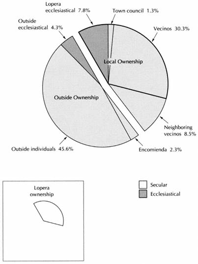
Figure 12.2.
Lopera, Ownership of Land, 1751
but to rent much of the plowed land. Outside owners naturally rented a greater proportion of their property because of the higher cost of administering from a distance.
The determining factor in their decisions appears to have been the proportion of the gross harvest that went to labor. The greater it was, the greater the tendency to lease the land. The difference in leasing pat-
| ||||||||||||||||||||||||||||||||||||||||||
terns between ruedo and campiña fields supports this explanation, for local institutions leased 52 percent of their ruedo lands (intensive rotations) but only 11 percent of their campiña lands. (No significant difference shows up for outside institutions.)
In this scheme, vineyards and huertas in Lopera appear out of line. Local institutions in Baños exploited vineyards directly; those of Lopera leased most of theirs. The reason is not apparent, but in both towns there were few vineyards, small samples to try to reason from. The huerta of Lopera is more easily explained. It belonged to the convent-hospital of the Order of San Juan de Dios, which had members—its eleven lay brothers—and perhaps convalescent inmates as well, who could labor in the vegetable plots. Like a Chayanovian peasant household, the convent could conceive of labor more as a fixed overhead cost than a variable input.
From the practices of the church, one can project the proportion of their property that outside lay owners leased and exploited directly (Table 12.6).
In calculating the division of harvests of Lopera among the different costs, one cannot apply the proportions determined for Baños (Table 11.11) without some modification. For one reason, the proportion of the harvest needed for seed was higher in Lopera, 19 percent compared to 15; for another, the product of the soil and olive trees was greater, resulting in a reduction in the amount of labor needed per unit of harvest.[13] Finally, owners in Lopera preferred to lease their vineyards. Table
[13] In Lopera an olive tree produced 32 percent more oil than in Baños (see above, n. 9). The mean harvest of a fanega of ruedo arable in Lopera was worth 164 reales, in Baños 87; of campiña land, Lopera 53, Baños 20.
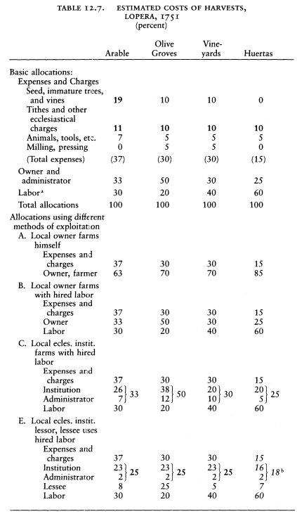
12.7 shows the results, in abbreviated form. The full table can be projected by following the pattern in Table 11.11.
Tables 12.6 and 12.7 permit one to derive the income of outside owners from lands they leased and from those they cultivated with hired labor (Table 12.8). How much of the harvests also left the town to pay outside administrators cannot be calculated as in Baños, for the catastro of Lopera does not identify administrators. The best I can do is apply the same proportions as in Baños, since we have found the leasing practices of outsiders to be similar.[14] The results are shown in Table 12.9.
Summing the results of Tables 12.8 and 12.9, one sees that a total of 4,498 EFW left the economy of Lopera in rent, harvests, and costs of administration of lands owned by outsiders. This is about 21 percent
[14] Drawing on Table 11.10, I assume the following proportions of lands in Lopera belonging to outsiders were administered from outside: arable, 70 percent; olive groves, 80 percent; vineyards, 100 percent; orchards, 100 percent; huertas, 60 percent. (The last two estimates are without supporting evidence, but the amounts involved are small.)
| ||||||||||||||||||||||||||||||||||||||||||||||||||||||||||||||||||||||||||||||||||||||||||||||||||||||||||||
| ||||||||||||||||||||||||||||||||||||||||||
of the total income from agriculture, which went to nonresidents as a result of their ownership of 52 percent of the land.
A number of houses in the town nucleus and other buildings also belonged to outsiders. Six of the eleven cortijos in Lopera (whose buildings were accorded a revenue independent of the fields) and thirteen of the twenty-two oil mills belonged to outsiders. The total income from their buildings was 16,140 reales, but allowing 10 percent for administration and 10 percent for upkeep, the net income was 12,912 reales (861 EFW). Part of the cost of administration would also have left the town; calculated according to the proportions known for Baños (see Table 11.10), this share would be 72 EFW.
3
Lacking extensive pastures, the vecinos of Lopera raised relatively few animals. Except for donkeys, which formed the working capital of the important group of muleteers, they had less than half the animals of each kind that Baños had and hardly more than a twentieth of the goats. The estimated annual product from animal husbandry is 1,243 EFW (Table 12.10).
Agriculture and livestock were the main bases of the economy of Lopera, but two activities provided income from outside. The more important was the business of transportation. As already noted, Lopera had twenty-one arrieros. They evidently had regular routes, for they are described as carrying goods (trajinando ) "on the highway of Madrid
| ||||||||||||||||||||||||||||||||||||||||||||||||||||||||||||
and other parts."[15] I assume that two-thirds of their income came from freight charges collected outside the town. At 200 reales per year per animal, their total income was reported to be 24,800 reales. Two-thirds of this represents about 1,100 EFW. The inns were the other source of revenue flowing into the local economy. Both run by the same mesonero, they gave him an income of 1,100 reales, and in addition he paid 840 rent to their owners, both vecinos. If, as assumed in Baños, about two-thirds of the total income came from charges levied on travelers, the inns brought 1,300 reales into the town, 86 EFW. This was a tiny sum beside the 1,430 EFW that Baños's inns produced, but travelers on the Andalusian highway had little reason to stop in the término of Lopera.[16]
Besides the share of the harvests taken by outside owners and administrators, the main payments leaving the economy were the tithes and other religious charges and the royal taxes. Because Lopera belonged to the jurisdiction of the Order of Calatrava, all the regular tithes on grain and olive oil belonged to the king as grand master. The crown had rented them out, however, in a contract (asiento ) covering the district of Porcuna, currently held by a banking house in Madrid.[17] The tithes on
[15] Lopera, resp. gen. Q 32.
[16] Ibid., for income per animal of arrieros. The rest from Lopera, maest. segl.
[17] Lopera, resp. gen. QQ 2 and 15. The asentistas are described variously as "la casa y thesoreria de los herederos de Da Lucia Gonzalez y Castañeda" and "casa thesoreria de los hijos y herederos de Dn Antonio de la Torre."
| ||||||||||||||||||||||||
grains and olive oil amounted to 2,740 EFW, but a local priest administered their collection, receiving a fee of one thousand reales (67 EFW), which stayed in the town.[18] The tithes on animals and vegetables, known as minucias, belonged to the comendador in Madrid, 97 EFW, but one may subtract 10 EFW for administration, which would stay in Lopera.[19] One outside landowner received payment in lieu of tithes, 13 EFW. The first fruits, paid in wheat and barley (63 EFW), belonged to local funds, one-third to the prior and two-thirds to the fabric, and so did most payments in lieu of tithes; but the Voto de Santiago left the town, 40 EFW. The total income of the Lopera church was 710 EFW, of which 564 came from its properties and the rest from tithes and payments in lieu of tithes. A quarter of this, my standard estimate of the amount spent for goods and services purchased elsewhere, was 178 EFW.
Secular imposts collected by the royal government added up to 340 EFW, as shown in Table 12.11.
We are now in a position to draw up the balance sheet for the income of the town (Table 12.12). The net total is approximately 19,700 EFW. Divided among a population of 1,260, this provided 15.6 EFW per capita, well over the 12 EFW threshold. If properly distributed among the vecinos, the income would give them all a comfortable living. But how well was it divided?
[18] Lopera, maest. ecles., no. 25.
[19] Lopera, resp. gen. Q 16.
| ||||||||||||||||||||||||||||||||||||||||||||||||||||||||||||||||||||||||||||
4
The vast majority of the men labored in the fields. The provincial summary of the catastro states that there were 195 jornaleros and 50 labradores, their sons, and their servants ("labradores inclusos hijos y mozos").[20] The local list of households identifies only 135 jornaleros, but by counting all the males eighteen and over who were likely to be engaged in agricultural labor, one arrives at a total of between 241 and 257, roughly equal to the total of labradores and jornaleros recorded in the provincial summary.
These men would have divided among them the share of the various harvests destined for labor. According to the figures posited in Table 12.7, this share would have been about 7,670 EFW (Table 12.13). Divided among the men working in the fields, this sum provided a per capita income of between 30 and 32 EFW. The catastro reports a daily wage of 2.5 reales for jornaleros and a similar income from their labor for the others who worked the land.[21] To reach the calculated per capita income, they would have had to work from 180 to 192 days annually, more than we found possible in Baños, and as many days as self employed farmers in Villaverde and El Mirón. In Baños the recorded daily wage was 0.5 real greater than in Lopera, and this difference helps explain why the calculations show such a large number of days of labor in Lopera. Since labor was evidently abundant in Baños and scarce in Lopera, this differential is suspicious. In fact, however, daily wages of 2.5 reales were reported for a number of towns in the valley of the Guadalquivir, while those in the foothills were 3 and in some cases 4 reales.[22] One seems well advised to believe the catastro and to propose a different explanation, namely that wages were low in Lopera because migrant labor was readily available.
If one ascribes to agricultural labor in Lopera 120 days of work per year (certainly not too low, since by my calculations the men of Baños had only 60 days of work in the fields of their town), each man would earn 20 EFW. I reason that whatever local women and children earned during harvests would come out of this amount. The portion of the total share of the harvests destined for labor that is left unaccounted for is 2,660 EFW, and this could be the amount paid to jornaleros from outside. If they took home with them 80 percent of their earnings, the net
[20] AHN, Hac., libro 7452, letra G.
[21] Lopera, resp. gen. Q 33.
[22] AHN, Hac., libro 7542, letra G.
| ||||||||||||||||||||||||||||||||||||
town income is reduced by 2,128 EFW (Table 12.12), and the per capita income of the town to 13.9 EFW, still 20 percent higher than that of Baños.
In Andalusia, the migration of labor adds an unknown factor to the calculation of town and individual incomes. Nevertheless, although the yearly income of agricultural laborers was arrived at independently for Lopera and Baños, the result, 20 EFW, is the same, and this provides a measure of confirmation for the estimates. Rather than being isolated units, the towns in this region were like connecting vessels, with labor flowing among them to establish a roughly unified labor market. The catastro provides no direct information on this phenomenon, but its data suffice to detect its existence.
At a higher level, much of the income of the vecinos came from lands they leased from outside owners. Who rented church properties is stated, but not the names of lessees of secular properties. From Tables 12.5, 12.6, and 12.7 (Method H), one can calculate that the total income of the lessees from the latter properties was 1,270 EFW. Since owners were more likely to rent to persons who could guarantee their contracts with their own property, as is evident in Baños, I prorate this income among the hidalgos, labradores, and clergymen of Lopera according to their known income from property, whether owned or rented from the church, and, in the case of clergy, their benefices. This additional source adds 26 percent to their income.
The income of the individual households can now be established, the
| ||||||||||||||||||||||||||||||||||||||||||||||||||||||||||||||||||||||||||||||||||||||||||||||||||||||||||||||||||||||||||||||||||||||||||||||||||||||||||||||||||||||||||||||||||||||||||||||||||
| ||||||||||||||||||||||||||||||||||||||||||||||||||||||||||||||||||||||||||||||||||||||||||||||||||||||||||||||||||||||||||||||||||||||||||||||||||||||||||||||||||||||||||||||||||||||||||||||||||||||||||||||||||||||||||||||||||||||||||||||
| ||||||||||||||||||||||||||||||||||||||||||||||||||||||||||||||||||||||||||||||||||||||||||||||||||||||||||||||||||||||||||||||||||||||||||||||||||||||||||||||||||||||||||||
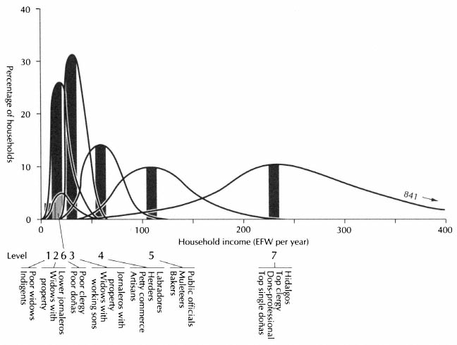
Figure 12.3.
Lopera, Socioeconomic Pyramid, 1751
NOTE : In Baños and Lopera the complexity of the structure calls for more
levels than elsewhere. Note that the top level was substantial and had very
wide economic limits. In Lopera the social elite was bimodal economically;
Level 6 is part of it and is just above the bottom. This is a bar graph based on
Table 12.14, with an indication of dispersion. It is not a set of frequency distributions.
total from land, animals, and a craft, business, or profession, and these results provide the socioeconomic pyramid for Lopera (Table 12.14 and Figure 12.3). The figures for the landed sector are on the low side, because these people would have owned some properties in adjoining towns, and I have not attempted to estimate this income.[23] The table is surprisingly similar to that of Baños (see Table 11.20). As there, a division into seven levels appears appropriate, and the income range in each level is roughly the same, indicating a similar social structure and economic condition. Yet there are peculiarities that distinguish the two towns and show that no one place should be considered typically Andalusian.
[23] Nearby vecinos and clergymen owned about a quarter as much land in Lopera as local vecinos and clergymen did. If vecino landowners of Lopera responded with a similar amount of property in neighboring towns, their rent from this land might add 10 to 15 percent to their net income, but Lopera was smaller than surrounding towns and its término was probably more exploited by vecinos of neighboring towns than vice versa.
5
The most striking differences are in the top category (Level 7), occupied by noble and clerical households. No household in Lopera had the wealth of the three richest people in Baños, a widow, an hidalgo landowner, and the parish prior. The top level had a lesser range of income, and that of the clergy was comparatively low. The highest stratum consisted of ten men labeled caballeros hijosdalgo and six single women evidently belonging to hidalgo families. On a per capita basis the latter were the most wealthy; their mean 235 EFW per household provided them with the wherewithal to maintain an ostentatious position and still amass an ever-growing fortune. For the men, the title of caballero hijodalgo was a mark of exclusive status, hidalguía, but it did not imply membership in the military order. The only person said to wear the habit of Calatrava was the prior; whatever perquisites he might draw out of his parishioners, his only recorded income came from his office and was under 100 EFW, a far cry from the wealthy priests of Baños. The others in the community called don—the doctor, the administrator of the royal tobacco monopoly, a labrador, and one whose occupation is not stated—were economically and socially lower but still part of the town notability. With them one can place clergymen with personal property, although some of their incomes were very modest. One commoner also belongs in this level, Francisco Díaz Serrano, the notary of the town council. His income places him very high, but he was not called don, although this appellation has been applied to the other notaries (escribanos) we have encountered. His income and activity make him a notable, and he may have belonged to a leading family. Díaz and Serrano were names of caballeros hijosdalgo, and a Díaz Serrano was a cleric in minor orders.
As can be expected, the notables belonged to family groups, but no families were as prominent as the best in Baños. The wealthiest member of the elite, don Ignacio Montilla, with 840 EFW income, could not compare with the widow Molina de la Zerda y Soriano of Baños. Although he had a household of fifteen, including five minor sons, three daughters, three maids, and a manservant who worked in the fields, he did not head a powerful family. No other hidalgo and no priest shared his surname, and he held no official position. The most important family was the Laras. At its head was don Pedro Josef de Lara, eighty-one years old, a widower, the holder of the royal jurisdiction in the town. Don Francisco de Lara, probably his son, the poorest of the hidalgos,
was also a widower, with two minor sons and two daughters, the future hope of the family. Don Juan de Lara was a priest, but his personal property and benefice gave him only 31 EFW per year.
The Lara family had three heads of household. None of the elite families had more, and among them a surprising number were spinsters ("de estado honesto"), six of whom were wealthy enough to belong in the highest level. Doña Balthasara Jil had an income of 615 EFW and a household that included a maid, five male servants for field work, and six shepherds. Her sister (or close relative), doña María Josefa Jil supported a nephew, a maid, and two male servants on her 354 EFW. Doña Josefa de Andújar belonged with them. Besides olive groves and grain fields, she owned three notarial offices (escribanías ) in the town, two of the council and one of royal taxes (millones), all of which gave her 205 EFW. The notary Matheo Díaz performed the official duties for her. Theirs were imposing houses, but no direct heirs would come out of them. The nephew of doña María Josefa Jil would probably inherit her wealth and that of her sister (if indeed she was her sister), but we do not know if he was a Jil. In the mid-eighteenth century a sense of family honor condemned the daughters of hidalgo families in Lopera to a solitary existence, as it did in Baños, and as it would in the house of Bernarda Alba two centuries later. In the process some lineages died out.
As in Baños, the elite families controlled the political structure of the town, although their authority was more veiled. The crown had preserved a voice for the representatives of the commoners in the municipal government, the Consejo de Capitulares. At its head was the aged don Pedro Josef de Lara, alcalde by virtue of his office as royal justice.[24] The council had five offices of regidor, two hereditary ("perpetuos") and three elected. One of the former belonged to a caballero of the Order of Calatrava who lived elsewhere and was represented by don Fernando Gutiérrez de Arce, hidalgo and military officer (teniente alférez mayor ), vecino of Lopera. Another belonged to a minor girl, and her proxy was another hidalgo in Lopera, who was himself alguacil mayor for the Inquisition of Córdoba and the owner of a regidor's office in Torredonjimeno, a town twice the size of Lopera forty kilometers away.[25] The noble estate of Lopera elected one of their number to be a regidor, and the commoners ("estado general") elected two of theirs. One of the
[24] The catastro does not give him the title "alcalde," but at the end of the century the person exercising royal jurisdiction was called alcalde (see AHPJ, Contaduría, libro 4465 [14 Nov. 1800], f. 373r; and AHPJ, Protocolos, libro 3980 [20 Feb. 1802], f. 19r–20r).
[25] Lopera, maest. segl., vecino no. 288.
latter was the procurador síndico (public attorney) and the other the padre de menores (guardian of public wards). The formal income of the regidores came from market fees and amounted to only 16 EFW each per year.[26] The commoner regidores were modest men; one of them had hardly any personal property and must have worked in the fields. Although modest, they appear to have had family ties with the elite. One was a Chiquero and the other a Bueno on his mother's side. A well to-do cleric in minor orders was named Bueno Chiquero, and two single doñas were Chiqueros, although too poor to be placed in the elite level. It is hard to avoid the suspicion that the devotion of these regidores to the public interest was tempered by other considerations.
Perhaps because it belonged to a military order, Lopera had a less exclusive society than Baños. As an example, the witnesses asked to swear to the exactness of the catastro came from all social levels. Among them, the royal judge, eighty-one-year-old don Pedro Josef de Lara, whose hand trembled as he signed, three regidores, the prior, and two other priests belonged to the elite. (The wealthy don Ignacio Montilla is conspicuously absent.) All the rest were commoners: the two regidores, the notary, the police officer (alcalde ordinario de la Santa Hermandad ), who owned no property, a labrador, a baker, a muleteer, a carpenter, and two jornaleros. Not social status but age gave them distinction. Except for the aged judge and the noble regidor, who was twenty-six, the others were between forty-five and sixty-three.
Other evidence of some social flexibility appears at the lower level of the elite, where the distinction between the dons and the commoners becomes slightly blurred. We have seen the connections of the notary and the commoner regidores with noble families. The Morales family provides another case. Three labradores had Morales as one of their surnames. So did a cleric in minor orders and a widow called doña. One of these labradores, Pedro Morales de Aguilera, may have been related to two hidalgos named Aguilera. The sense of honor did not prevent family ties from developing across social estates at the boundary where they met economically.
One must visualize the elite of Lopera differently from that of Baños. Rather than a collection of families of which a few were dominant (and richer than the richest in Lopera), the leaders of Lopera seem a corporate body of people who distinguished themselves by the label caballero hijodalgo. Perhaps this phrase appeared only in official documents, but
[26] Lopera, resp. gen. Q 28.
it was reserved for certain people and gave expression to their superior status. The wealthiest women, whose position did not allow them to marry beneath their station, belonged with them. This corporate body dominated the economy by extensive holdings in land, and the greater wealth of Lopera redounded to the benefit of its members—ten of the eleven caballeros hijosdalgo and three of the six single women in this group had incomes over 100 EFW; only seven of a larger group of landowning notables in Baños reached this level. They controlled the municipal administration, formally by their official positions and informally by patronage. Family ties and the ownership of office connected them with their counterparts in other towns of the region, a relationship critical to their position, for a large proportion of the town's land was in the hands of outsiders.
6
In the pyramid just below the privileged elite I have placed two groups on the basis of their claims to social status, for their wealth or income would locate them in the lower levels. One of these is clergymen with only their benefice to live on. The rule of José María Blanco that one needed personal wealth to become a priest did not apply here, for over half the clerics in town had no property of their own. In Baños the smallest capellanía was worth 16 EFW; in Lopera seventeen of thirty capellanias produced less than this, a corollary to the small amount of land in ecclesiastical hands. Single ladies called doña with pittances to their name and all the widows called doña are the second group in this level. The clergy must have benefited from fees for masses and other services and from the administration of properties, activities that cannot be traced in the catastro. The women could hardly have flourished, however, since they had no servants and some not even a relative to live with them. They could cling to the status of their wealthier relations and scorn the commoners who had more than they did, but even if genteel, theirs was a hard-pressed life of counting cuartos and ochavos, whose need offered commoners the possibility of entry into the privileged ranks through marriage.
Below the privileged elite, in the top level of the commoners—those with household incomes over 100 EFW—the most prosperous group was the twenty-one muleteers. We recall that muleteering gave La Mata its remarkable well-being. Here too transportation was an organized undertaking, and its practitioners prospered. The catastro credits them
with a mean income from their calling of 84 EFW. This figure could be suspect, based on a round sum of two hundred reales per pack animal (and it probably ignores the amount spent outside the town for feed), but their prosperity is evident, for their activities spilled over into the local economy. Several farmed land that they owned or rented, raising their income by another 50 percent. Entrepreneurial spirit guided them, not a desire to switch activities, for those who had the largest pack trains also did the most farming. At their head Benito Merino, with seven animals (93 EFW), had 79 EFW from land. Two arrieros joined muleteering with baking and made almost 100 EFW from each. Their choice was hardly a coincidence, for bakers were the other group that belonged in the top level of commoners, as they did in Baños. The bakers too were entrepreneurs; three of the five panaderos rented olive groves and grain fields although they owned no land of their own.
At this level let us also place the public officials—regidores of the common estate, tax collector, grain steward of the military order, and schoolmaster. Their household income did not reach 100 EFW, but they had small households (the regidores were bachelors) so their per capita income was substantial. In any case, their official positions would add to their status and place them with the top commoners.
The storekeepers, master craftsmen, and labradores, who attained the top income of commoners in Baños, here fall into the middle range (Levels 4A, 4C, 4D). Indeed the labradores of Lopera were modest farmers, whose known income, even when credited with a share of the return on lands leased from outside owners, gave their families less than 12 EFW per person per year. Nevertheless, their social status was greater than their income would warrant. As we saw, they shared family names and probably family ties with the hidalgos.
Below the middle range but above poverty, as in Baños, come the widows with working sons at home, who could support them. Here too are the lesser public and church servants, and the jornaleros with property of their own. Out of the 135 jornaleros, 85 are in this group, a larger percentage than in Baños. Sixty-three owned their house, 15 owned or rented some land, 21 had donkeys, and 11 had pigs, goats, or other animals. The household incomes of these jornaleros place them in this level, but their family per capita income was below 12 EFW because their families were numerous.
Finally one reaches the poor, the propertyless day laborers, the single women, the widows without the help of able-bodied sons, the mendicants, and the blind. Almost all the women who headed households
owned the house they lived in, but only four at this level had any animals. They worked, of course, as did their minor children, and the widows must have received charity, as did the blind and mendicants, so that more came into their homes than the catastro reveals. But most of the members of the families in these levels (2 and 1) surely dressed in rags and gave reality to the contemporary picture of Andalusian poverty. In this level were 30 percent of the households, 6 percent more than in Baños, proof that the greater per capita income of the town did not mean a better distribution of wealth. The structure of the elite might differ, and the relative economic position of the upper occupations of the commoners, but for the majority of the vecinos and vecinas it made little difference whether they lived in Baños or Lopera, except that the jornaleros of Baños left their town periodically to seek work.
7
The only information I have on the evolution of Lopera in the eighteenth century comes from the available censuses. These are of varying reliability, but they all concur in showing that the population grew steadily after the end of the War of the Spanish Succession. Furthermore, the rate of growth was increasing (Table 12.15). In 1786 the reported population was 1,407,[27] by 1826 it was 2,016.
The list of occupations in the 1786 census does not shed light on the evolution of the economy. It shows a small but reasonable growth in the number of labradores, artisans, and male servants.[28] A figure of 83 jornaleros where there had been 135 in 1751 is clearly a miscount: the total number listed for all occupations is 95 less than the male population over twenty-four. On the other hand, only 10 hidalgos are reported (there had been 12 "caballeros hijosdalgo" in the catastro), 4 priests (there had been 7), and 1 cleric in minor orders (there had been 9). If accurate, the figures show that notables and clergy were declining in numbers, especially the latter. The falling off of clerical vocations, so marked in Spain after 1800, may already have begun, spurred on here by the insignificance of the capellanías combined with economic well-being. Another suggestive item is that the Inquisition no longer had an agent in Lopera in 1786.
The officials of Lopera did not respond rapidly to the royal orders of
[27] For the 1786 census of Lopera, see Appendix N, Table N.6.
[28] Labradores, 15; artesanos, 18; criados, 49.
| |||||||||||||||||||||||||||||||||||||||||||||||||||||||||||||||||||||||||||||||||||||||||||||||||||||||||||||||||||||||||||||||||||||||||||||||||||||||||||||||||||||||||||
1798 to disentail the property of ecclesiastical endowments. Not until September 1800 were the first sales concluded. They began with the property of the wealthiest local confraternity, the Cofradía de San Bartolomé. Sales continued into 1801, then slowed down. There were fifteen sales in all, and they disposed of land belonging only to local confraternities and obras pías. Every one of them lost some property, although far from all they had. As in Baños, the clergy avoided the sale of any of the endowments of the capellanías, and neither of the two outside ecclesiastical institutions that came under the royal orders was touched.[29] By comparison with the other towns studied, Lopera had little property disentailed. The sales covered only 1.2 percent of the arable and 1.5 percent of the olive groves. Since the church owned rela-
[29] The sales are recorded in AHPJ, Protocolos, libro 3979 (1800), ff. 175–203 passim; libro 3980 (1801), ff. 11r–12v, 207r–208v; libro 3982 (1804), ff. 150r–152v; libro 3983 (1806), ff. 191r–194v; and in AHPJ, Contaduría, libro 4465, ff. 350–389 passim.

Figure 12.4.
Lopera, Population Structure, 1786
NOTE : Since there is no limit to the top age group, a
span of seventeen years is used for convenience only.
tively little here, however, its loss was not inconsequential: about 10 percent of all ecclesiastical property in town, 16 percent of the holdings of the local church.[30]
When church properties first went on sale the demand was lively, but it rapidly weakened. In mid-1800 a vecino chose to bid on an olive grove, thus forcing the authorities to offer it at auction. The assessors measured it and declared its value to be 13,000 reales. Bidding forced the price up to 13,899 reales, at which the original bidder got it.[31] An-
[30] The identification of the properties sold shows that since the catastro a new obra pía had been founded by don Francisco Feliz de Aguilera, a landowning hidalgo of 1751. For lack of other information, I assume that the property of the obra pía that was disentailed was all he had endowed it with, 25 percent of all the property disentailed in Lopera, and that this was all the property that the church had acquired in the town since 1751. The other disentailed properties can be identified in the catastro as belonging to the church at that time.
[31] Buyer don Alonso de Rus y García, AHPJ, Protocolos, libro 3979 (29 Nov. 1800), ff. 209r–210v.
other vecino, wanting to make sure that he got a grain field of five fanegas, assessed at 315 reales per celemín, offered 400 reales per celemín, which took it. He paid in specie (en metálico ), giving two-thirds the agreed price, as permitted. (Vales were then worth barely one-third their face value in hard currency.)[32] At the end of the year, however, an olive grove went at its assessed value in vales reales, "there having been no other bidder," the notary observed, perhaps in surprise.[33] From then on almost all sales were paid for either in vales reales (meaning that no one had raised the bid by offering specie) or at two-thirds the assessed value in specie, the lowest the law allowed. Only two small sales in 1801 and 1804 give evidence of competition among buyers.[34] In Lopera land could always be found on the open market, and at the prices set by the assessors church properties were not bargains. One purchaser, for instance, who paid 5,010 reales for a grove of seventy-four olive trees in 1800 got another with sixty-eight trees for 2,256 reales by private sale in 1803.[35] Unlike the villages of Salamanca, where land seldom changed hands, in these towns of Jaén there was an active real estate market, and the hunger for church properties was less acute.
Because Lopera had such a market, one cannot assume that the distribution of property was the same when disentail began as at the time of the catastro, and therefore one cannot know the distribution after disentail. As in the case of Baños, one can only show how the sales compared with known holdings in 1751 (Table 12.16). Outside lay owners gained slightly, adding less than 1 percent of their holdings in 1751, an olive grove and a grain field bought by a resident of Córdoba. Vecinos gained more, both relatively and absolutely, 3.5 percent of their holdings in 1751. These changes would hardly be perceived in the town economy. The processions and other activities of the confraternities might be somewhat curtailed when the crown stopped paying interest on the resulting debt to these funds, but in no way could the disentail be seen as a shock to the social or economic order.
Yet the disentail has much to tell us about that order. Twelve persons made purchases, and almost all of them turn up in the records of the
[32] Buyer Pedro Moreno el menor, ibid. (23 Sept. 1800), ff. 175r–176v.
[33] Buyer don Cristóbal de Ventas, ibid. (29 Nov. 1800), ff. 203r–204v (AHPM, C3000).
[34] Buyer Rus y García paid 2,360 reales for property assessed at 2,145 (AHPJ, Protocolos, libro 3980 (14 Nov. 1801), ff. 141r–142v); Miguel de Alcalá paid 2,340 in efectivo, the minimum allowed bid was 2,023 (ibid., libro 3982 (15 Aug. 1804), ff. 150r–152v (C36741).
[35] Don Cristóbal de Ventas, n. 33 above and AHPJ, Contaduría, libro 4465 (11 Nov. 1803), f. 385v.
| |||||||||||||||||||||||||||||||||||||||||||||||||||||||||||||||||||||||||||||||||||||||||||
notaries and the property register in other transactions during these years (Table 12.17). What kind of person decided to buy church lands?
Don Juan Nepomuceno Morales, a lieutenant colonel in the royal army, resident in Córdoba, was the individual who spent the most money. He bought one of the finest properties in Lopera, an olive grove of 462 trees on first-quality land and also eight fanegas of grainland, both acquired in 1803.[36] Why did he choose Lopera for his investment? He made his purchases through an agent, Antonio de Balenzuela, vecino of Lopera. In 1802 Balenzuela rented a mill and other property in Córdoba belonging to the alcalde of Lopera and his wife, doña María Antonia Morales (sister perhaps of don Juan Nepomuceno Morales). Doña María Antonia guaranteed her part of the contract with an olive grove of 516 trees in Porcuna (adjoining Lopera).[37] One can conceive of don Juan Nepomuceno as coming out of a modest notable local family (in 1751 the last name Morales belonged to the poorest widow addressed as doña and to a cleric in minor orders with no land of his own).
[36] AHPJ, Protocolos, libro 3981 (15 Mar. 1803), ff. 34r–54v, ff. 55r–82v (both C34544).
[37] Ibid., Contaduría, libro 4465 (4 Aug. 1802) f. 381r.
| ||||||||||||||||||||||||||||||||||||||||||||||||||||||||||||||||||||||||||||||||||||||
| |||||||||||||||||||||||||||||||||||||||||||||||||||||||||||||||||||||||||||||||||||||||||||||||||||||||||||||||||||||||||||||||||||||||||||||||||||||||||||||||||||||
He may have met Balenzuela through his sister and brother-in-law, hearing about property coming on the market in Lopera, close upon his sister's olive grove, and engaged Balenzuela to get him a share of the bonanza. The disentail introduced a new landowner made wealthy by military service in recent wars against France and Portugal.
Balenzuela is an interesting figure in his own right. A commoner, he made his way by serving the town's elite. Dealings with the outside world were his specialty. In 1802 the alcalde of Lopera commissioned him to go to Córdoba to arrange for the rental of the olive groves and mill owned in Lopera by the convent of Santa Clara in Córdoba. The convent's holdings recorded in the catastro were impressive; this was a major lease.[38] When a resident of Jaén wanted to take out a censo (lien) on some houses he owned in Lopera, Balenzuela was the lender. At the same time Balenzuela bought from this man an olive grove in Lopera with twenty-two trees.[39] Although he never purchased any disentailed property, he also acquired a corral from a private owner during these years.[40] Clearly an upwardly mobile spirit.
The largest purchaser was the army officer Morales. The largest single sale, however, an olive grove of 773 trees, went jointly to three sisters, doña Margarita, doña Inés, and doña María Josefa Montilla y Zevallos, vecinas of Lopera, all "de estado honesto over twenty-five years of age, who rule and govern their personal property without care of any tutor or guardian whatsoever."[41] But they did use an agent for their purchase, our friend Antonio de Balenzuela. One may recall that don Ignacio Montilla was the wealthiest hidalgo in 1751. He had three minor daughters. Are these the same three sisters, now in their sixties and seventies, or are they daughters of one of his five sons? Since the catastro does not give their names or the surname of their mother, one cannot know. In either case, they were condemned to spinsterhood, like so many women of hidalgo families, but they had money and knew how to use it. No sooner had they bought the olive grove than they put it up as collateral to rent a holding of 205 fanegas from the Condesa de Isla Fernández, an outsider. The contract ran for six years, and the rent was 3,250 reales per year.[42] Whatever their age, these ladies were aggressively engaged in agricultural business.
[38] Lopera, maest. ecles., no. 29; AHPJ, Protocolos, libro 3980 (20 Feb. 1802), ff. 19r–20r.
[39] AHPJ, Contaduría, libro 4465 (20 June 1802), f. 380r–v.
[40] Ibid. (26 Dec. 1799), ff. 361r–362v.
[41] AHPJ, Protocolos, libro 3983 (27 Apr. 1806), ff. 47r–84v (C59224).
[42] AHPJ, Contaduría, libro 4465 (30 Sept. 1807), ff. 352v–353r.
Who should appear as the next purchaser but one don Miguel de Montilla y Padilla, undoubtedly another descendant of don Ignacio Montilla, a cousin or nephew of the three sisters. He bought two grain fields of high quality, 7 fanegas in all, almost a third of the arable to be disentailed.[43] His interests were broad and varied. To start with, he owned one of the hereditary offices of regidor in Lopera. Not content with this office, he was trying to establish a claim to an option (tanteo ) on the other one. He had taken the case to the Council of Castile, offering to pay the owner 6,000 reales or whatever the council decided was a just price, and he had hired a lawyer in Madrid to represent him.[44] He had extensive properties. In Lopera he enjoyed a mayorazgo described by one notary as "a vast entailed fortune" ("grueso caudal vinculado").[45] In addition he owned several houses and lots in town,[46] and in Martos, the cabeza de partido, a cortijo with a house with tile roof and 221 fanegas of land, which he rented for 3,300 reales per year.[47] Dealing in property came naturally to him. One finds him, besides making purchases from the disentail, buying an olive grove in 1799 with 136 trees for 12,132 reales and two large olive groves and a major house in Lopera in 1800 for 71,168 reales (three times what he paid for his church lands) and selling a building lot in 1801 and several houses in 1804.[48] He lends money against a censo in 1802 and owes the local encomienda a censo that he backs with his mayorazgo; he hires a fellow vecino with connections in Madrid to collect debts due him.[49]
The most interesting information that one acquires about Montilla, however, is that his brother-in-law is don Manuel Francisco de Zevallos Guerra, Conde de Villafuertes, a caballero of the Order of Calatrava, gentleman of the royal chamber and colonel in the royal armies, a vecino of the north coast port of Santander. It is he who sells Montilla the handsome olive groves in 1800. He had inherited them from don Francisco Xavier de Zevallos, the absentee regidor of 1751, also of the
[43] AHPJ, Protocolos, libro 3979 (4 Sept. 1800), ff. 167r–168v (A6800); (12 Nov. 1800), ff. 199r–200v (C3001).
[44] Ibid., (26 Jan. 1801), ff. 3–4; libro 3980 (4 Aug. 1801), ff. 86r–87r.
[45] Ibid., libro 3979 (26 Jan. 1801, bound incorrectly in 1800), ff. 3r–4v; also see libro 3980 (3 Jan. 1802), ff. 3r–4v.
[46] AHPJ, Contaduría, libro 4465 (12 Aug. 1801), ff. 375v–376r; (16 Nov. 1804), f. 340r.
[47] AHPJ, Protocolos, libro 3980 (12 Sept. 1801), ff. 99r–102r.
[48] AHPJ, Contaduría, libro 4465 (14 Dec. 1799), f. 361v; (16 Nov. 1804), f. 340r; AHPJ, Protocolos, libro 3979 (11 Dec. 1799), f. 231; (7 Aug. 1800), ff. 157r–160v; libro 3980 (12 Aug. 1801), ff. 88r–91v; libro 3982 (13 Nov. 1804), ff. 204r–207v.
[49] Ibid., libro 3980 (3 Jan. 1802), ff. 3r–4v; (21 July 1802), ff. 82r–v; libro 3979 (27 Feb. 1800), ff. 13–14.
Order of Calatrava.[50] Surely he had also inherited the regidor's office, and Montilla had bought it from him, as he is now trying to buy that of the other hereditary regidor. The family connections do not stop there, for the three enterprising sisters, besides being Montillas on their father's side, are Zevallos on their mother's. A small world, but it reaches to Córdoba, Madrid, and Santander and embraces a count with access to the royal court.
In the mid-eighteenth century don Ignacio Montilla had wealth and hidalguía, but public office had escaped him. At that time no other head of household in Lopera shared his name. Half a century later his descendants have enhanced the family fortune and social standing and have penetrated the town council. The alcalde's office still escapes them—don Antonio de Berdejo y Piedrola occupies it, a descendant of don Bernardo Berdejo, caballero hijodalgo and "young bachelor" ("mozo soltero") in 1751. Since the death of don Pedro Josef de Lara, the eighty-one-year-old alcalde of the catastro, the Lara family, then predominant in the town, has disappeared from the official scene, and the Montillas are rapidly taking their place, the new and expansive poderosos of Lopera.
To collect his debts, Montilla hired don Alonso de Rus y García. The next one down the list of buyers, Rus y García is almost as fascinating as Montilla. One of the earliest buyers, between September 1800 and November 1801 he acquired a medium-sized olive grove (148 trees) and two small but excellent plots of land.[51] A native of Lopera, he had made a career in the army, rising to be a mariscal mayor in the Reales Guardias de Corps and a vecino of Madrid.[52] There was no family named Rus in Lopera in 1751, but the Ruiz were prominent: the labrador called don, two widows called doña, and the priest with the largest personal estate. Rus's name was a corruption of Ruiz; in fact the notarized documents call him variously de Rus, de Ruz, and de Ruiz. With him this family too had prospered.
We can picture don Alonso de Rus returning to his native town with his wife about the time the disentail was proclaimed (in 1799 he is called a resident, by 1801 a vecino).[53] One of his first acts is to donate a new altar in the parish church dedicated to the image of Holy Mary of Tribu-
[50] For the property of F. X. Zevallos, Lopera, maest. segl., ff. 458–78.
[51] AHPJ, Protocolos, libro 3979 (25 Sept. 1800), ff. 141r–142v (C621) (haza); (29 Nov. 1800), ff. 209r–210v (C2999) (olivar); libro 3980 (14 Nov. 1801), ff. 141r–142v (C21524) (pieza de tierra).
[52] See ibid., libro 3979 (23 Nov. 1799), ff. 225r–226v; (27 Feb. 1800), ff. 13–14 (where he is called a vecino of Madrid).
[53] See ibid., libro 3980 (29 June 1801), f. 62r–63v.
lations, endowing it with a censo for eleven hundred reales against houses that he owns in the town.[54] Having made this display of his religious and civic spirit, he enters forcefully into the local economic life. In 1800 Montilla hires him to collect his debts. By 1801 he is the administrator of the properties of the Conde de Lainez of Madrid. Among these are two notarial offices (escribanías públicas ) in Porcuna, Lopera's larger neighbor to the south, which Rus rents to the notary of Lopera (notaries too could be active in more than one town).[55] The notary's surname is García; so is Rus's wife's and Rus's mother's. In the same year he and his wife act as guarantors (fiadores), pledging his purchases from the disentail, for the contract of his brother to farm the royal revenues of Marmolejo (the next town to the north) and for that of his brother-in-law to farm the royal revenues and tobacco monopoly of Lopera.[56] (Tax farming can become a family affair that embraces more than one community.) Finally in 1805 Rus himself gets the administration of the revenues of a capellanía in Lopera.[57] We lose sight of him here, army officer wise to the world of Madrid returned in glory to his modest Andalusian town, where he can exploit his family connections and discover a gift for business and public relations.
For the town doctor, the royal decree came at an inconvenient time. Don Juan Alejo Pérez was engaged in a legal tangle in Jaén in 1799—he had to hire two advocates attached to the episcopal court to handle his problems, both civil and ecclesiastical.[58] This litigation left him short of cash, for the next year, when he bought a handsome mule for 1,500 reales, he had to give a note to guarantee future payment.[59] But he was not destitute, since he owned a fine house on the corner of the town square. In 1801 he could not resist acquiring a one-fanega plot of church land that no one was bidding for, but his funds were still scarce. He paid one-quarter of the price down (a mere 1,001 reales) and the rest in two annual installments, plus 3 percent interest, putting up his house as security, one of the few buyers who took advantage of this method of payment.[60] By 1806 his finances had recovered enough to permit him a second purchase of church land, a small olive grove.[61] A doctor was a
[54] Ibid., libro 3979 (23 Nov. 1799), ff. 225r–226v.
[55] Ibid., libro 3980 (29 June 1801), ff. 62r–63v.
[56] Ibid., libro 3980 (29 Sept. 1801), ff. 103r–106v; (26 Sept. 1801), ff. 107r–110v (also in AHPJ, Contaduría, libro 4465, ff. 376r–v).
[57] AHPJ, Contaduría, libro 4465 (4 Aug. 1805), ff. 342r–v.
[58] AHPJ, Protocolos, libro 3979 (4 July 1799), ff. 166r–v.
[59] Ibid. (5 May 1300), f. 121r–v.
[60] Ibid., libro 3980 (19 Jan. 1801), ff. 11r–12v.
[61] Ibid., libro 3983 (18 Dec. 1806), ff. 191r–194v (C51397).
respected figure in society with an emolument from the town council, but his profession did not place him economically in the top level of the notables any more than it had in 1751.
Two other vecinos whom the notaries called don made relatively small purchases. Don Juan Luis Rivilla turns up nowhere else in the notarial records of this period.[62] Don Cristóbal de Ventas was the buyer of an olive grove of seventy-four trees at the outset of the sales and another of sixty-eight trees by private purchase in 1803.[63] The enterprising veteran don Alonso de Rus gave him power of attorney in 1802.[64] He was a part of the elite, even if a small part, both by title and by connections.
Only three men who bought ecclesiastical properties were not entitled to the appellation don. All appear elsewhere in the notarial records of these years, although one, Miguel de Alcalá, only fleetingly. His was the smallest purchase, a small field of medium quality. He paid 2,340 reales in specie for it in 1804, over 300 reales above the minimum, having fought off other interested parties.[65] Two years later he bought a mule from a dealer in Granada for 2,100 reales (almost as much as his field). Lacking cash, he gave the dealer a note with his house as collateral.[66] A labrador?
Francisco de Paula Peralta y Gutiérrez may have been another labrador; he was much more enterprising. From the disentail he acquired a field of almost four fanegas of low quality, which he got for the minimum price, 5,303 reales in specie.[67] Earlier he had bought an olive grove of fifty-three trees from the second hereditary regidor for 3,700 reales.[68] In 1799 he lent another vecino 3,000 reales in specie for six weeks, and in 1806 he obtained the administration of the properties of a capellanía, putting up several houses as collateral.[69]
The third commoner was more active, Pedro Moreno the younger ("el menor"), identified in a contract as master farrier and veterinarian.[70] At the outset of the sales he bought five fanegas of top-quality
[62] Ibid., libro 3979 (12 Nov. 1800), ff. 195r–196v (C1824).
[63] Ibid. (29 Nov. 1800), ff. 203r–204v (C3000); AHPJ, Contaduría, libro 4465 (11 Nov. 1803), f. 385v.
[64] AHPJ, Protocolos, libro 3980 (4 Oct. 1802), f. 172r–v.
[65] Ibid., libro 3982 (15 Aug. 1804), ff. 150r–152v (C36741). The field was assessed at 233 reales per celemín (1/12 fanega). Assessments ran from 145 to 315 reales per celemín for plowed land.
[66] AHPJ, Contaduría, libro 4465 (14 Apr. 1806), ff. 346r–v.
[67] AHPJ, Protocolos, libro 3980 (31 Dec. 1802), ff. 207r–208v (C21523).
[68] Ibid. (7 May 1802), ff. 38r–39v.
[69] Ibid., libro 3979 (6 June 1799), f. 158r–v; AHPJ, Contaduría, libro 4465 (20 Mar. 1806), f. 345v.
[70] Maestro de herrador y albeitar.
ruedo land, which he obtained by bidding 27 percent above the assessed value.[71] A year later he bought twenty-nine fanegas of arable from the Marquesa de Monte Olivar, a nonresident, a purchase that made him one of the largest owners in Lopera.[72] He did not let these lands lie idle; by 1807, when he used them to back a contract, they were already planted with young olive trees.[73] He was equally into other businesses. He bought three mules from dealers in Granada, every time giving notes specifying future payment.[74] He probably was reselling them and others for which he paid cash and of which we have no evidence. He also was available as a fiador, for a price, of course. In 1800 he put up bond for a prisoner in the town jail and in 1803 acted as guarantor for an hidalgo who farmed the income of a religious endowment. As his guarantee, he put up several houses and an olive grove.[75] Finally, in October 1807, just before we lose sight of the town, he obtained the administration of the tavern belonging to the municipal council.[76] Unlike the wealthy hidalgos, who had connections outside Lopera to enhance their position, these three commoners operated within the confines of the town. Moreno, the most active, used his position as veterinarian to rise to the status of landowner and tavernkeeper. The purchase of church properties represented one rung in his career.
Although the acquisition of church land did not alter profoundly the position of anyone in Lopera, in almost every case it marked the purchaser, whether commoner or noble, as a driving, ambitious member of the community. Nine of the twelve belong in the top socioeconomic category (Level 7 in Table 12.14), the other three in the middle range (Level 4). The bottom three levels, 60 percent of the households in 1751, did not have a look in. It is striking how many business and family connections related this small group of buyers to each other. Of course, they worked with other people as well, but these men and women formed the core of the active sector of the community.
No doubt such people had always been present, yet the last half century seems to have encouraged them. The catastro gives evidence of an elite that resembles a corporate body with connections reaching outside
[71] AHPJ, Protocolos, libro 3979 (23 Sept. 1800), ff. 175r–176v (C620). Assessed 315 reales per celemín, bid 400, paid 2/3 of bid in specie.
[72] Ibid., libro 3980 (16 Oct. 1801), f. 179r–182v. The price is not given.
[73] AHPJ, Contaduría, libro 4465 (1 Oct. 1807), f. 353r.
[74] Ibid. (15 July 1799), ff. 358v–359r; (26 Mar. 1803), ff. 383v–384r; AHPJ, Protocolos, libro 3979 (6 May 1800), f. 123r–v.
[75] AHPJ, Contaduría, libro 4465 (25 May 1800), ff. 371v–372r; (31 Dec. 1803), f. 386r.
[76] Ibid. (1 Oct. 1807), f. 353r.
the town. The activities of the buyers of church property add new dimensions to this picture. Here, in a relatively insignificant town in the upper Andalusian valley, the driving figures of the community had interests that spread to the neighboring towns, where they had land and offices and relatives in leading places. Family and business tied them to Córdoba, much more their metropolis than Jaén, and to Madrid, where one buyer had made his career as an officer in the royal guards and another was a plaintiff before the Council of Castile and could boast of a titled brother-in-law who knew the king.
The regional network of hidalgo families linked the town notables into a greater society than that bounded by their geographic término. They could count on support from outside, as guarantors and as marriage partners. When a local family disappeared for lack of heirs, others in the region were ready to step in and take over their interests, either by a direct move or through their proxies. A poor member of the notability might consider a wedding with a commoner, but at the socioeconomic summit, any vacuum was filled with peers from elsewhere. The agricultural laborers flowed from town to town like water between connecting vessels; far above them so did the members of the hidalgo society, maintaining intact the film that they spread atop the rural world. Even more clearly than at the time of the catastro, they formed an integrated regional elite, one with national connections. The foundation of nineteenth-century oligarchic constitutional politics was emerging.
Chapter XIII—
Las Navas De Santisteban Del Puerto
To reach the last of our seven towns, the traveler had to leave the highway of Andalusia and the famed valley of the Guadalquivir and go to what in the eighteenth century was the northeastern corner of the province of Jaén. (Today the province extends further to the northeast, having incorporated portions of the old-regime provinces of La Mancha and Murcia.) Here one finds the largest stretch of truly flat land in the province—for all its fame, the valley of the upper Guadalquivir is a rolling countryside, not a plain—the valley of the small Rio de Montizón, a tributary of the Guadalén, itself a tributary of the Guadalimar, which flows into the Guadalquivir east of Bailén (how persistently the Arab word for "river" lived on in the Iberian countryside!). The valley lies between the Sierra Morena to the north and a ridge to the south that separates the Montizón from the Guadalimar. This ridge, though low, is impressive enough that the town at the northern end of the best road through it is called San Esteban (or Santisteban) del Puerto (Saint Stephen of the Pass) and is watched over by an impressive ancient castle. The other towns controlling the valley, Las Navas to the west of Santisteban and Castellar to the east, also lie on passes through the ridge, with the broad valley at their feet.
The valley is of rich, red soil, still today devoted mainly to grain, although there are a few olive groves and live oaks. The ridge on which the towns sit is also of red earth, sandstone in origin, as is the Sierra Morena north of the valley, quite distinct in this respect from the yel-
lowish white sedimented marl of the Guadalquivir, once under sea level. The Montizón valley is geologically part of the Sierra Morena.[1]
In the eighteenth century these three towns had a common término, Las Navas and Castellar being aldeas (villages) of Santisteban. Together they formed the señorío of the Duque de Santisteban del Puerto.[2] We shall look at the smallest of the three, Las Navas, located above the western limit of the valley, where the hills close in on the Montizón, prior to its confluence with the Guadalén. Its término has little flat land, but it stretches south over the ridge and down to the Rio Guadalimar, which divides it from the término of Ubeda, the largest city in the region. Mostly upland monte, it did not offer a very promising site for an agricultural economy. Of the 23,400 fanegas listed in the catastro (11,200 hectares),[3] 14,000 were called useless, another 4,000 were dehesas, and only 3,130 plowed land. One recalls that Baños, whose término was nearly seven times the size of Navas's, also was largely monte, the Sierra Morena above the town, but Baños had its llano, with a clearly defined ruedo and campiñuela. Living on the margin of the fertile valley of the Montizón, under the jurisdiction of Santisteban del Puerto, the vecinos of Las Navas were as if expelled from the garden of paradise, condemned to look over the wall at those within. One is reminded of El Mirón on its hill above the valley of the Corneja, but El Mirón was the cabeza of its partido.
The town itself is located in a saddle at the top of the ridge (at 653 meters), where it can dominate the lands on either side. At its center are two small squares. The parish church watches over the Plaza del Molino. Nearby the smaller Plaza del Pozo was in those days the site of the ayuntamiento, which housed also the town prison.[4] Facing on this square were the butcher shop, the barber shop, and the houses of two "labradores peujaleros," as they were called here (a pegujalero is a small independent farmer), one of them an alcalde ordinario, the other an alcalde de la hermandad (police officer). Most other vecinos lived in 166 habitable houses that lined the town's twelve streets. (Thirteen other houses were in ruins or uninhabitable, a higher proportion than in Baños or Lopera.) On the edge of the town and slightly above it, the ruins of a small castle bore witness to the strategic value of the location. Outside the nucleus there were nineteen cortijos and casas de campo
[1] Information provided by don Juan Manuel Medina Ruano of the Servicio de Extensión Agraria, Arjona, May 1969.
[2] AHPJ, Catastro, Navas, resp. gen. QQ 2, 3.
[3] See Appendix N, Table N.4, for the equivalents of the different local fanegas.
[4] Navas, resp. gen. Q 23.
| ||||||||||||||||||||||||||||||||||||||||||||||||||||||||||||||||||||||||||||||||||||||||
(the latter located in olive groves, as the cortijos were in grain fields), but some of these were not inhabited the year round, since only fourteen families lived in them.[5]
Navas was smaller than either Lopera or Baños. The libros personales de legos and de eclesiásticos list 264 vecinos and a population of 988 (Table 13.1). The sex ratios suggest an underregistration of females, especially those under eighteen (forty to fifty are missing), indicating a correct total of approximately 1,030. As will become evident, however, there are reasons to believe that the catastro did report all those living in the pueblo. The population was smaller than the 1,830 calculated for Baños and 1,260 for Lopera. In Baños there were 1.48 households per habitable house, in Lopera 1.08. The figure for Navas was 1.59. From the outset one senses less affluence (or greater poverty) in Navas than the other two Andalusian towns.
Table 13.2 and Figure 13.1 show the heads of household and their occupations. Its most striking feature is the high proportion of people engaged in agriculture: 81 percent, highest of all the towns studied except the farmstead Pedrollén. The closest, the sierra town of El Mirón, had 72 percent. Navas is also unique in that none of its vecinos considered transportation his major occupation. Only two laymen, the doctor and the notary, bore the title don, which they evidently enjoyed because
[5] Ibid. QQ 22, 23; libro personal de legos; maest. segl., nos. 194–97 (Plaza del Pozo) and 247–60 (cortijos and casas del campo).
| ||||||||||||||||||||||||||||||||||||||||||||||||||||||||||||||||||||||||||||||||||||||||||||||||||||||||||||||||||||||||||||||
| |||||||||||||||||||||||||||||||||||||||||||||||||||||||||||||||
of their professions, for the census of 1786 lists no hidalgos in the town. The occupational structure adds an image of isolation, both social and geographic, to this community.
The patterns of crop rotation confirm the first impression of an unpromising site. On the best arable land, the vecinos alternated crops of wheat and barley, with a year of rest after each. On second-quality land, the same pattern applied, except that there were two years of fallow after each planting. Third-quality land did not bear wheat at all but was used for barley, rye, or escaña (Saint Peter's corn) in no particular rotation, but with three years' fallow between plantings. Of the 3,100 fanegas of arable, under 7 percent was in the top category, able to bear a crop in alternate years; at the other extreme, 57 percent could be farmed only once every four years and never with wheat. Relative isolation and the small harvest of wheat go far to explain its price: eighteen reales per fanega, the highest we have seen, whereas the price of barley and rye was close to that elsewhere, though on the high side. Table 13.3 gives
Figure 13.1.
Las Navas, Employment Structure, 1752
the usual two estimates of the annual harvests, and the seed requirement.
The estimate of the harvests can be only approximate. The two methods of calculating it—prediction from the stated harvest on a fanega of each quality of arable and the number of fanegas of each quality in the town, and projection from the reported tithes—are far from agreeing. Elsewhere I have used the tithes as more reliable, although, where they were farmed, as here, no accurate records may have been available to the makers of the catastro. In Navas the catastro reports tithes in kind for wheat and barley only. By assuming that the tithe farmers kept 10 percent for themselves and reported only the rest, I get a "best estimate" of these crops. Tithes on the other crops were included by the catastro in a lump sum in money that covered also vegetables and animals. One can only accept the predicted figures. The best estimate for the total gross harvest is 5,098 EFW.
There is also uncertainty about the proportion of the harvest that was retained for seed. According to the figures provided by the catastro, the yield-seed ratio for wheat was 8 : 1 on first-quality land, 9 : 1 on second, with an overall average of 8.7 : 1.[6] For poorer land to give a better ratio
[6] Navas, resp. gen. Q 9: First quality, 1 fanega of seed per fanega of land, harvest 8 fanegas; second quality: 8 celemines seed, 6 fanegas harvest.
| |||||||||||||||||||||||||||||||||||||||||||||||||||||||||||||||||||||||||||||||||||||||||||||||||||||||||
than good land goes contrary to practice, even with longer fallow, and in any case the ratios are probably not accurate because they are higher than reported elsewhere. I shall estimate the mean ratio as 7 : 1. The ratio reported for barley is within the expected range: 7.5 : 1 to 9 : 1, with a mean of 8.3 : 1, which I shall use (but again the ratio is better for second- than first-quality land). The ratio for rye is an unreasonable 20 : 1, for escaña, 10 : 1. I use 10 : 1 for both. The results are included in Table 13.3. My best estimate for the net harvest after seed is 4,432 EFW, but there is a strong possibility that the seed ratios are still high and that this is an overestimate.
About half as much land was devoted to olives as to grains: 1,622 fanegas. The olive oil production is also difficult to estimate. From the quality and extent of the groves one predicts 8,354 arrobas of oil. The tithes were reported in money, and at the current price, fifteen reales per
arroba, the harvest works out to be only 4,815 arrobas.[7] A way out of the dilemma is to consider the product of each tree. From the number of trees reported and the tithes collected, the mean return per tree in Baños is 0.087 arroba of oil, for Lopera 0.116, and for Navas 0.078. The figure for Navas is suspiciously low, and I shall use the slightly higher one of Baños as the best estimate, since its terrain is similar. It gives a harvest in Navas of 5,400 arrobas, or 4,500 EFW. Although the land in olives was little more than half that in grain, its product was greater.
The town also had its orchards and irrigated huertas, but as elsewhere, these contributed little to the town income, although they added greatly to the amenity and salubrity of life. The vecinos distinguished between fig trees (about five fanegas, with thirty trees per fanega), which produced a harvest of 4 to 6 reales per tree, and other fruit trees (about fourteen fanegas with ninety-three trees each)—pomegranates, quinces, and peaches are mentioned—whose crop was worth only .75 real per tree. The total fruit harvest came to about 100 EFW. The irrigated huertas were divided between hemp (cañamo ) and vegetables (hortalizas ). Twenty-five fanegas (more irrigated area than either Baños or Lopera had) produced about 380 EFW. The total net return from agriculture was approximately 9,412 EFW (Table 13.10).
2
Table 13.4 and Figure 13.2 show the distribution of property ownership. Navas differs from the other two Andalusian towns in the proportion of property owned locally: 36 percent compared to 72 percent for Baños and 48 for Lopera. In this respect, Navas resembles the towns within the economic orbit of Salamanca city (La Mata, 29 percent; Villaverde, 31 percent). It cannot be classed with them, however, because half or more of the land held by absentees in the Salamanca towns was ecclesiastical and rented to vecinos who farmed it for their own account. Here the bulk of the land held by absentees belonged to only two people, both titled nobles in Madrid, the Duque de Santisteban del Puerto, señor of the town, and the Conde-Duque de Benavente.
Although the catastro does not say so, it is likely that both properties formed part of their family entails. Santisteban owned the town castle and, more significantly, four cortijos and extensive olive groves with an oil mill and a casa de campo; Benavente two inns, one a mesón in the town nucleus, the other a venta a quarter of a league from it, plus two
[7] Ibid. Q 16: tithes, 6,500 reales.
| |||||||||||||||||||||||||||||||||||||||||||||||||||||||||||||||||||||||||||||||||||||||||||||||||||||||||||||||||||||||||||||||||||||||||||||||||||
cortijos and the largest olive groves of the town, with their casa de campo and oil mill.[8] Eighty-five percent of the olive groves belonged to these two men, and olive oil represented 57 percent of the town income from agriculture.
[8] Ibid. Q 29.
Figure 13.2.
Las Navas, Ownership of Land, 1752
A look at these men's property reveals much about the town structure.[9] Santisteban's olive groves were 939 fanegas in extent (about 450 hectares), located in the hills and surrounded on all sides by uncultivated monte. The oil mill was located here. It was built around a patio
[9] Navas, maest. segl., ff. 206–14 (Santisteban); ff. 215–25 (Benavente).
where the olives were piled after being harvested. Three naves housed four millstones, eight "beams" or presses (vigas ), four cauldrons, twenty-four large earthenware amphoras (tinajones ) for distilling and separating the oil that drained from the presses, and a storage room (bodega ) with ninety-nine containers (vasos ). Adjoining was an office, a shed for horses, and a hayloft (pajar). The whole complex measured forty-three by thirteen meters. The casa de campo and another smaller permanent house were nearby, and nine tiny dwellings linked to the former, where "the families [of the workers] live during the olive harvest."
One can visualize the activity in his olive groves during the winter harvest season. The jornaleros of Navas, with their women and older children, would walk in the morning to the duke's estate, half a league away, where they would shake down the trees with long sticks and gather up the olives off blankets spread on the ground. They would then load the fruit on donkeys to take to the patio of the mill. From there specialized workmen would place the olives on the millstones to be lightly crushed by a conical stone rolled around on top of them (being careful not to spoil the flavor by breaking the pits). The workers then loaded the mash in the presses, first placing a round esparto mat on the floor in the middle of the press, then a layer of mash, another esparto mat, another layer of mash, and so on until a pile sufficiently high had been achieved for the pressing to be effective. The beams were then lowered on top of the pile to squeeze out the oil. The liquid would run into the first large tinajón, where gravity separated oil from water, and then, as the oil was decanted from one tinajón to the next—a process requiring days—the purer oil would rise to the top and be drawn off to sell at a higher price than the rest. At day's end, most jornaleros would return to the town, but some, including those who worked in the mill, would bed themselves down in the nine small houses. The harvest would go on for days, and the mill would operate for some time more, until all the olives piled in the patio had been ground and pressed and their oil distilled.
The duke's four cortijos were more extensive than his olive groves, 1,257 fanegas, but only 24 percent of them were cultivated, the rest being monte bajo. Benavente had 940 fanegas of olive groves and 3,300 more in two cortijos, but only 8 percent of the latter were cultivated and 15 percent more were recently planted with live oak (chaparro ), presumably to be used for pasture. These two aristocrats were after olive oil, not grain, as were the majority of outside owners in all three of our Andalusian towns.
| ||||||||||||||||||||||||||||||||||||||||||||||||
The leases described in the catastro indicate that the practice here was to rent land for one-fifth of the harvest.[10] In the other two towns of Jaén province, the owners received a quarter of the harvest. In Navas, the practice appears to have compensated the tenant for the poverty of the land.
Because the volume describing ecclesiastical properties is lost, one can achieve only an approximation of the proportions of each kind of land that church officials chose to rent and to farm themselves (Table 13.5). Outside secular owners are assumed to follow the same preferences as outside religious institutions. Besides the two aristocrats, twelve outsiders owned land in the termino. One had extensive holdings, an hidalgo of Arjona, seventy-five kilometers away, near Lopera, who owned three cortijos (16 percent of the arable in the town). The others owned arable and a few huertas, for the only outsiders to have olive groves besides the aristocrats were three nearby vecinos, who I assume cultivated their properties themselves and are not included in this table. (As in other towns, I count their properties as locally owned to
[10] The makers of the catastro were required to state the local rate for rents in Navas, maest. ecles., but this is lost. Details on thirty-seven leases of ecclesiastical property held by twenty-six vecinos are given at the end of the maest. segl. In twenty-eight cases the tenant is assigned between 79 percent and 81 percent of the harvest. Six cases ranged from 58 to 69 percent, one was 76 percent, and two were over 81 percent. There is no pattern in the kind of land that was reported to rent for more or less than 80 percent, and these cases may well have involved errors in calculation by the maker of the catastro.
balance out properties assumed to be owned in nearby towns by vecinos of Navas.)
Tables 13.4 and 13.5 reveal a form of dual economy in the town. Olive groves, whose product was destined for an outside market, belonged almost exclusively to the aristocrats in Madrid. Grain fields and huertas, most of whose harvest was consumed in the community, were in the care of vecinos. Vecinos and the local church owned two-thirds of them, and vecinos tilled most of the rest through leases. Cortijos also produced grain, but these belonged to outsiders. Of eleven held by laymen, only one belonged to a vecino, the notary (escribano, one of the two laymen in town favored with the title don ), and another, tiny, to a nearby vecina. How many of those owned by outsiders were farmed directly rather than leased cannot be determined with assurance. Two vecinos received salary in kind from the Duque de Santisteban as managers (caseros ) of two of his cortijos, and another as manager of a cortijo of the Conde-Duque de Benavente. The registrar (notario público ) was also a casero of Benavente. These four cortijos were clearly exploited directly, with local stewards. The notario also administered the three cortijos of the hidalgo of Arjona, but for these he received only 1.2 percent of the harvest in cash, indicating that he was only the agent for leasing them to other vecinos who exploited them for their own account.[11] This leaves only two cortijos belonging to laymen whose disposition is unknown. One cortijo belonging to the parish church was leased, but we do not know how many ecclesiastical cortijos were farmed directly.[12] As a reasonable approximation, I assume that half of the value of cortijos owned by outsiders was leased to vecinos (Table 13.5).
My estimate of the division of harvests among the different costs of production follows the method used in the last two chapters (Table 13.6). Using these percentages, Table 13.7 calculates the income to outside owners from their properties in Navas. Table 13.8 gives an estimate of the income of their administrators who do not reside in Navas. Since the catastro provides no information on this topic, I assume the same pattern as found in Baños. The result may be too favorable to Navas, that is, I may have allocated too much property of outsiders to local agents, because Navas lacked a class of wealthy landowners and beneficed clergy such as those in Baños who administered properties for outsiders.
[11] Navas, maest. segl., nos. 211 and 267, property of don Juan Lucas Talero: harvest, 11,286 reales; administrator's fee, 135 reales. The other information also comes from this volume.
[12] In 1800 the collegial church of Ubeda sold a cortijo of almost 300 fanegas. Most likely it already owned the cortijo in 1752 and was administering it itself.
| ||||||||||||||||||||||||||||||||||||||||||||||||||||||||||||||||||||||||||||||||||||||||||
| ||||||||||||||||||||||||||||||||||||
Outsiders also monopolized the nonresidential buildings in town. The casas de cortijo are a case in point. In addition, the aristocrats owned both casas de campo, two of the three oil mills, and the two inns. As elsewhere, though, most houses in the nucleus belonged to vecinos. They had five-sixths of the houses that belonged to laymen. The total value of buildings belonging to outsiders (expressed in annual income) was 643 EFW. Administration and costs took about 20 percent (129 EFW), but of this, 39 EFW is the estimated share of outside administrators.[13]
Summing the results of Tables 13.7 and 13.8 and the income of outsiders from buildings gives a total of 3,099 EFW. This is 33 percent of the total net return from agriculture, derived from the ownership of 64 percent of the land, plus attached buildings (and two small inns). In Lopera the outsiders' share was 21 percent, in Baños only 11 percent. The vecinos of Navas not only had poorer land, they received a smaller share of the product, despite the more generous leasing arrangements. They owned the small plots, but nonresidents held the big ones, the cortijos, and the olive groves. Most of these belonged to their señor and another titled noble. If this is what señorío meant, it was not favorable to the vassals.
3
As a community with extensive pastures and vacant monte, Navas might be expected to have large herds of animals. Surprisingly, this was not the case. It had fewer sheep than Lopera, although Lopera lacked monte, and relatively few pigs, but the vecinos did own more cattle per head than those of the other two towns of Jaén. Table 13.9 gives the number of animals and estimated annual income from raising livestock, a total of 784 EFW. In addition the vecinos owned 346 beehives producing 114 EFW.
Income also accrued to the town from outside. In Baños we found that the jornaleros left during part of the year to work elsewhere. The same phenomenon becomes apparent in Navas. The reported daily wage of jornaleros was three reales; labradores and their sons made four reales per day.[14] The total of one day's wages of the jornaleros and labradores noted in Table 13.2, plus twenty-four sons of jornaleros and labradores and twenty-one male servants, would come to 36 EFW. The share accruing to labor from arable and olive groves, 2,654 EFW, would
[13] Calculated as for Baños, Table 11.10.
[14] Navas, resp. gen. Q 35.
| ||||||||||||||||||||||||||||||||||||||||||||||||||||||||||||
thus account for only 74 days' labor. In this length of time, a jornalero would earn only 12.3 EFW. If, as in Baños, jornaleros could work another 30 days elsewhere, bringing home 80 percent of their earnings, the town income would rise by some 870 EFW. A jornalero would still be making only 17.3 EFW, about 3 EFW less than what we found in the other two towns.
Crafts and the inns also offered the possibility of income from outside. Among the craftsmen, the four sandalmakers (alpargateros ) stand out. Making the alpargatas worn throughout southern Spain by the modest levels of society was a regional specialty. Most of the towns in eastern Jaén had a number of alpargateros, but those of the west of the province had few.[15] Hemp was the most valuable crop of the huertas of Navas, and it was the main material for the sandals. The alpargateros may have sold three-fourths of their production outside the town. Their income, a rough equivalent of the value added, three reales per day for 180 days, would bring 90 EFW into the town annually.
The other source of funds from outside was the two inns. The gross return stated for the venta on the road beneath the town was fifteen hundred reales, that of the mesón in the town thirty-three hundred rea-
[15] AHN, Hac., libro 7452, letra G, provincial summary of the catastro.
les. According to our formula, about two-thirds of this income came from nonresidents. However, the Conde-Duque de Benavente, the inns' owner, received in rent fifteen hundred reales, leaving a net income for the town of seventeen hundred reales, or 95 EFW.
Besides rent payments, the charges against Navas included seigneurial dues as well as the customary ones to king and church. Payments to the señor were surprisingly light: two charges to cover his justice: the penas de cámara of 50 reales per year and the penas de ordenanza of 30 reales (a total of 4 EFW).[16] The king had once granted the duke the tercias reales, the royal two-ninths of the tithes, and the alcabalas, or sales tax, but the town council had bought from the duke the right to collect both these imposts.[17] To do so it had borrowed heavily in the form of censos from a capellanía and a mayorazgo located in nearby towns. The capital of these censos was 89,100 reales, and the 3-percent interest amounted to 149 EFW.[18]
Far heavier were the charges levied by the crown. The town council paid the royal treasury 5,891 reales (327 EFW) per year—the name of the tax is never stated. Of this, 5,000 came from the alcabalas and tercias it collected; the rest it apportioned among the vecinos and outside property owners. The council also paid the king 1,187 reales (66 EFW) for servicio ordinario y extraordinario, apportioned in the same way.[19] If the assessments on owners were proportional to property owned (and assuming that nobles were exempt), outsiders paid 11 EFW and the remaining 382 EFW left the town economy. More modest was the council's contribution to royal troops in transit, put at 200 reales (11 EFW) per year.
The catastro of Navas is less specific about ecclesiastical charges than those of other towns. How much of the town's income they withdrew from the economy is therefore uncertain, but one can obtain a reasonable approximation. Partible tithes were divided among the tercias reales (kept by the municipal council), the local fabric and prior, and a number of outside authorities: the bishop and cathedral of Jaén, an archpriest, a vicar. The shares of each are not stated, and the libro maestro de eclesiásticos, which would clear up the issue, is lost. If the prior got a third and the fabric its usual ninth, one-third left the town. This would be 328 EFW. The first fruits went to the local clergy, but the
[16] Navas, resp. gen. Q 4.
[17] Ibid. Q 23.
[18] Ibid. Q 26.
[19] Ibid. Q 27.
Voto de Santiago (15 EFW) was exported, less 10 percent to the person who farmed it. The bula de la cruzada cost the town 80 reales (4 EFW), and the town council contributed 29 reales (2 EFW) to "the holy places of Jerusalem." Payment in lieu of tithes on exempt lands owned by outsiders amounted to 6 EFW.[20] Finally, insofar as they can be determined, the expenditures of the parish church outside the community, estimated as before at one-quarter of the income of its funds, were 192 EFW. On these assumptions the church withdrew from the town economy 546 EFW, more than the crown and señor together.
Information is now available to draw up the balance sheet of the town (Table 13.10). The estimated town income, with all the uncertainties that have become evident, is 7,174 EFW.[21] Divided among a likely population of 1,030, this gives a per capita annual income of 7.0 EFW, far below that of any other town studied and little more than half of the 12 EFW assumed to provide an adequate rural income.
There has been uncertainty at many points, the average size of the harvest, the yield-seed ratio, the number of cortijos exploited directly by outsiders, the expenses for outside administration. My estimates, although conscientious, may be low (although in the case of seed, outside administration, and cortijo exploitation, higher figures would mean less rather than more town income). Olive oil production may have been greater (but if so, most of the increased figure would accrue to the outside owners). The population was also in doubt. The low number of women reported in the catastro[22] may not be the effect of underregistration but of temporary out-migration into service in urban centers: Ubeda and Baeza were flourishing minor cities nearby, and the census of 1786 shows that both had more females than males aged sixteen to twenty-four.[23] The recorded population of 988, if correct, would mean a per capita income of 7.3 EFW, not much of an improvement.
The figure may still be too low, but all the obvious corrections have now been applied. Equivalent fanegas of wheat (EFW) may be a misleading unit here, because wheat was expensive compared to other grains,[24] but, since wheat was the major grain, any correction would not
[20] Ibid. QQ 16, 25.
[21] For Navas, I have calculated the amount that individuals paid in interest on censos. Payments were moderate and can be omitted from the calculation of individual and town incomes without weakening the analysis. (See Appendix M.)
[22] See Table 13.1.
[23] Ages 16–24 in 1786 census: Ubeda, 951 males, 1,130 females; Baeza, 741 males, 857 females.
[24] Wheat-rye price ratios: Navas, 1.8 : 1; Baños, 1.56 : 1. Wheat-barley: Navas, 2 : 1; Baños 2 : 1; Lopera, 1.67 : 1.
| ||||||||||||||||||||||||||||||||||||||||||||||||||||||||||||||||||||||||||
| ||||||||||||||||||
be over 10 percent. One cannot escape the conclusion that Navas was a poor community. All the information in the catastro strengthens it: the poor soil with long periods of fallow, the near monopoly of outside owners over cortijos and olive groves, the greater number of families per house. These features make it unique among our seven towns. It will add to our understanding of Spanish rural life to see what effect they had on the social pyramid and the relative position of the different sectors of society.
4
The socioeconomic pyramid of Navas provides a very interesting comparison with those of Baños and Lopera (Table 13.11 and Figure 13.3). In the other towns an important sector of wealthy landowners and professionals, many of them hidalgos, dominated the pyramid and the community. In Baños forty households made up this top level, in Lopera thirty-three, respectively 8 and 10 percent of all households. In Navas only six households, those of the doctor and notary, both called don, and of the clergy are comparable (2 percent of all households). Only three of them had incomes over 100 EFW and could live like gentlemen.
Their households embodied their status. Don Francisco Martínez, the prior, drawing on his more than 300 EFW per year, "maintains at his expense," as the catastro put it, a widowed brother-in-law, a niece, two serving women, and an adult (over eighteen) male servant, the latter presumably to work in the fields of the priory. The notary, don Francisco Lorenzo Salcedo y Navarrete, forty-nine years old, had a more
| ||||||||||||||||||||||||||||||||||||||||||||||||||||||||||||||||||||||||||||||||||||||||||||||||||||||||||||||||||||||||||||||||||||||||||||||||||||||||||||||||||||||||||||||||||||||||||||||||||
| ||||||||||||||||||||||||||||||||||||||||||||||||||||||||||||||||||||||||||||||||||||||||||||||||||||||||||||||||||||||||||||||||||||||||||||||||||||||||||||||||||||||||||||||||||||||||||||||||||||||||||||||||||||||||

Figure 13.3.
Las Navas, Socioeconomic Pyramid, 1752
NOTE : This is a bar graph based on Table 13.11, with an
indication of dispersion. It is not a set of frequency distributions.
extensive family: wife, four sons (one over eighteen), two daughters, a maid, and two male servants (one over eighteen). Besides being escribano, he is also listed as a labrador peujalero. In his case peujalero is hardly appropriate, for he had more land than anyone else in the town. The only vínculo belonged to him and included the only cortijo owned
by a vecino. His other lands were arable and a sizable olive grove with the only oil mill of a vecino. His total income was over 280 EFW. Since he had only one adult manservant, he was a big employer of jornaleros, one of the few local people that had the wherewithal, both economic and political, to attract a network of clients.
The town doctor, don Joseph Antonio Tortosa, belongs with these two because of his income and his appellation, but he was not of their stature. Twenty-three and still a bachelor, he had living with him only a maid, and he had no property in town. Perhaps he was a newcomer. But his utilidad as doctor was judged to be 2,260 reales per year (126 EFW), the highest professional income in the community. His position had great potential, and it is a pity one cannot observe his household and position twenty or thirty years later.
These three men, although impressive in the community, could not compare in wealth and way of life with the leading figures of Lopera and Baños, whose incomes were over 500 or even 1,000 EFW. They also lacked other essential characteristics of the elites of Lopera and Baños. They were not heads of powerful families, nor did they form a corporate oligarchy united by marriage ties. The family names of the notary, Salcedo and Navarrete, and of the doctor, Tortosa, belonged to no one else in the community. Although several members of the lower groups were Martínezes, like the prior, the name is common and may not connote any blood relationship. Even among themselves, these three leading men do not appear to have been related.
Like the prior, the other three priests also had maids and belonged socially to the top group. Economically it is hard to place them, however, because the relevant book has been lost. The parish curate (cura ) received some of the first fruits (perhaps 18 EFW), but the only local capellanía of which record remains, because it leased some lands, brought in only 3 EFW in known income. Even if all the unidentified local church properties belonged to capellanías, the most they would have brought in to these three priests was about 130 EFW altogether. They also had income from saying masses and administering some church funds (but not all, since the notario, a sandalmaker, and the carpenter each administered a fund). Whatever their income, these priests could not match the display of the prior.
The leaders of the community were not these few individuals but the labradores peujaleros, the thirty-six male heads of household and the seven widows. They were a relatively large group, 16 percent of all households. Although their highest incomes surpassed all but those of
the notary and the prior, their average income and their style of life consign them to a second level. Of all the groups we have observed in the various towns, they were the closest to the concept of the villano honrado of the seventeenth century or the Anglo-Saxon yeoman farmer. Unlike the wealthy labradores of La Mata, who leased their fields, they had lands of their own, 42 percent of the arable not in cortijos, 8 percent of the olive groves, and about 10 percent of the other kinds of property, plus a large number of cattle. Many of their households were self-contained units. Together they had eleven sons and twenty-one adult male servants. The labor of these labradores and their sons and mozos in many cases was enough to till their holdings, so that they did not have to resort to hired hands. They rented most of the grain fields that were leased by ecclesiastical institutions and without doubt most of the fields of outside lay owners. Francisca Alonso de Gámez, a widow labradora peujalera, rented the one cortijo whose lease we have a record of, belonging to a local obra pía. Others probably leased the other available cortijos.
A spirit of enterprise imbued the labradores peujaleros. Recently a fever for olive groves had gripped the town; more and more land was being taken from the monte or out of grain production to plant trees with the intention of selling olive oil on the national market. The expected returns made this investment attractive, although it meant that the land would produce no income for ten to fifteen years. One can surmise that throughout the province of Jaén the transfer of lands from arable and pasture to olive groves was in progress, and it continued for another two centuries, turning it into one of the major centers of olive oil production in the world. The catastro of Navas provides specific evidence of the extent of this development, since it lists as a separate item the olive groves recently planted and still not producing, reporting their acreage but attributing them no income. Besides 1,722 fanegas of mature trees and 136 of dead trees, the town had 331 fanegas of new groves, a recent addition of 18 percent. The labradores peujaleros were much more aggressive than this. To 60 fanegas of mature groves belonging to them, they were adding 33 and had 9 more uncultivated, ready for planting, a total addition of 70 percent. They conceived their exploitations as commercial ventures and were responding to the incentives of the market. (By comparison, the two dukes, long aware of the commercial possibilities of olives, were adding another 14 percent to their groves, less in proportion than the labradores but much more in area, 205 fanegas.)
A look at several labradores gives meaning to this description. Juan de Siles was thirty-four years old, married with a son and daughter, and owned a comfortable but not luxurious house on the main street, the Calle Real. His wife took care of the house since there was no maid (no labrador had a maid), but three adult menservants lived with them and worked on his fields. His property included five grain fields totaling thirty fanegas, and two olive groves. One of these had about 150 mature trees, half the other was newly planted and the rest still vacant. He was extending his olive production. These properties brought him net (before labor) some 56 EFW. In addition he had numerous livestock: eight cows and twelve young, three goats with four young, and two horses, all of which provided him with perhaps another 15 EFW. Also living in Siles's home was a twenty-year-old jornalero named Antonio Pérez (physically or mentally disabled, perhaps), whose guardian Siles was, administering his property. This brought in 20 EFW, and Siles may have kept half for his efforts. Siles did not rent any ecclesiastical lands, but he must have rented secular lands, since with three male servants and Pérez, he could have tilled twice as much land as he owned and administered. After rent, wages, and keep of his servants, his net annual income was in the range of 105 EFW, not the highest of his group but near the top.[25]
Although Cristóbal de Mercado lived in a bigger house on the same street, his establishment was less imposing, with only two grain fields and a small olive grove of his own (they hardly brought in 6 EFW). From a local obra pía he rented a large field that produced for him another 13 EFW, and he probably rented secular lands as well, for he had an adult son living at home (but no farm hands). His other wealth was a flock of twenty sheep and, at the moment, thirty lambs, and he owned his own yoke of mules. Forty years old, with a wife, two minor children, and a total income of perhaps 45 EFW, he was one of the more modest labradores peujaleros.[26]
What was special about these two men was that they were the two regidores of the town. The town council consisted of two other men as well, the alcaldes ordinarios. These were also labradores peujaleros, Pedro Calvo, aged fifty, living with his wife on a net income of some 52 EFW, including 7 as alcalde; and Balthasar Rodríguez, forty-eight, with wife, three young sons, an adult manservant, fields, olive groves, huerta,
[25] Navas, libro personal de legos; maest. segl., vecino no. 23.
[26] Navas, maest. segl., vecino no. 11.
and more rentals from the church than anyone else. He was the wealthiest labrador of all, 155 EFW income. On his death he would endow a capellanía in his name with an olive grove and huerta to support the local clergy.[27] The other town officials were two guardians of the peace, the alcaldes de la hermandad, one a labrador peujalero and the other a jornalero (aged twenty-nine and twenty-five).[28] Except for the last person, the town government was firmly in the hands of the labradores peujaleros, most of them young and vigorous. Their authority was limited by the imposing figure of the notary; by the public attorney, the síndico procurador general of Santisteban del Puerto, whose responsibility included the affairs of Navas; and finally by the power of the duke their señor, who appointed them, choosing in each case from two names presented by the town council.[29] But the labradores peujaleros formed the backbone of the local economy and society and ran its government. It was their ancestors who had led the town in buying out the duke's interest in the tithes and alcabalas.
The local elite here was not the pinnacle of society but the more numerous second level of farmers, men who worked with their hands and whose wives kept their houses, cared for their children, fed them and their hired hands, with occasional paid help, no doubt, from the daughters of the jornaleros, and took over the agricultural exploitation if an untimely death should carry off their men. Unlike the notabilities of Lopera and Baños, they were not an exclusive group nor a collection of ruling families. The forty-three labradores and viudas labradoras had thirty different surnames. Only nine of these were repeated among them, but all but six belonged also to vecinos with other occupations. Cristóbal de Mercado, the regidor, was undoubtedly related to Juan Ruiz de Mercado, his more wealthy next-door neighbor, another labrador, but also to Juan de Mercado el menor, a jornalero. Antonio Megino, aged sixty, a labrador with three sons at home, lived next to Diego Megino, aged twenty-nine, a jornalero with two sons and already a widower, surely Antonio's son or nephew. A few proto-dynasties appear, notably the Torres family. Its households included three labradores, an unmarried doncella, and a widow, both women with lands of their own. They resembled an hidalgo family, but there were also two propertyless Torres widows, one with an adult son who was a jornalero. Distant
[27] The lands of the "capellanía colativa fundada por Balthasar Rodríguez" were disentailed in 1808 (AHPJ, Contaduría, libro 4412 [26 May 1808], ff. 283v–284r).
[28] Navas, libro personal de legos, vecinos 103, 197, 196, 215; Navas, resp. gen. Q 32.
[29] Navas, resp. gen. Q 28.
relatives or a coincidence of names? In any case the wealthy Torreses were almost unique.
Had the olive groves and cortijos of the two dukes been in the hands of a local hidalgo class, this class would have run the town, as it did in Lopera and Baños. But the dukes were in Madrid, and vecinos, including two labradores peujaleros, ran their estates for them. The prior and the notary could not by themselves form an elite, and so leadership of the community fell to their social inferiors. One comprehends why the notary wanted to be recorded in the catastro as a labrador peujalero although his income, education, and style of life placed him in a different world. The strength of his patronage could not match the social leadership of the labradores.
The rest of the social structure conforms more closely to that of the other two places. The innkeepers, the holder of the tobacco monopoly, and the notario rank just beneath the top level along with the labradores. The owners of livestock earned a little less. They concentrated their attention on their flocks of goats, which ran from 30 to 264. This activity did not provide the prestige of farming, for they had neither public office nor family relations with the labradores.
Public officials fall, as expected, in the middle level, but bakers and artisans, who are in this level also, are further down the pyramid than in the other two towns. The difference, which is probably real and not the effect of the makers of the catastro, can be explained by the absence of a substantial upper sector. Crafts flourished on the clientage of the conspicuously wealthy, and the labradores peujaleros were not of this kind. The same must have been the case of the four bakers.
They did not feel inferior, however. The olive fever had bitten them, as it had the labradores. To their 2.5 fanegas of olive groves, the owners of livestock and the market gardeners were adding 4.5 more; to 13 fanegas, the butchers, bakers, and storekeepers were adding 5; the notario, who owned only 6 fanegas of land, had 3 in new trees; while three craftsmen (the shoemaker, the blacksmith, and a sandalmaker), with 1.5 fanegas of mature trees among them, had 10 fanegas more growing, leaving them only 5.5 in grain! These men found olives, with their better market and lower proportional cost of labor, a capital gain worth waiting for.
When we descend to the jornaleros, family size and per capita incomes do not differ greatly from the previous towns. The slightly lower earnings attributed to them in EFW represent almost the same in reales, because of the higher price of wheat here. Were they better or worse off? Since the households of the labradores provided most of their own labor
and the dukes' olive groves gave no steady employment, were they not more squeezed? The majority here, as in Lopera and Baños, had some property, a field or two, a donkey, some goats or a pig, even a cow. Four had small olive groves and three others had seedlings sprouting. But odd jobs were scarcer than elsewhere. There was less money floating around the top that could filter down to their family members. They probably ate less than the jornaleros of Baños and Lopera, and we know they were crowded into fewer houses.
Were they better off psychologically? The answer depends on the social integration of the community, and specifically on the relations between the labradores and their inferiors. Were the labradores "villanos honrados," yeoman farmers, or were they incipient kulaks, "rural bourgeois"? Their olive planting showed them to be enterprising, and they preferred not to rely on day laborers. Does this mean that they were standoffish, a ruling class?
The catastro of Navas provides a side of town life that we have observed nowhere else. It says who lives on each street. If one maps them out, one obtains an interesting pattern (Figure 13.4). Town life had two foci, the Plaza del Pozo and the Calle Real, a block to the west. Of the thirty-six labradores and widow labradoras who lived in the town itself, all but nine had their house on one of these foci or within a block of the plaza. The notary lived on the Calle Real, the doctor and tobacco dealer on the nearby Plaza del Molino, on which the parish church faced, the notario on the street between the two plazas. (We do not know where the priests lived.) This was the area of the storekeepers and the inn. There were a few artisans here too, but they were more widely scattered. Plenty of jornaleros and others in the bottom levels lived on these streets, mixed in with the better-off vecinos, but when one moved farther away from the foci, the streets were lined almost entirely with the houses of the poor. It is as if the town nucleus had its own von Thünen's rings: the elite, the storekeepers, and labradores at the center, mixed with households of all social levels, a second ring that lacked the top levels but had still its artisans, market gardeners, and livestock owners, and an outer ring almost exclusively poor, except for an occasional labrador.
The congregation of the better off in the center of the town, typical of early modern urban geography, meant that the vecinos would be aware of economic differentiation, but it did not mean rigid social stratification, at least not of the kind of Lopera and Baños. Nor should one exaggerate the spatial differentiation, for no place was more than three streets away from one of the town foci. It was a small community, and everybody rubbed elbows with everybody else frequently. The labrado-
Figure 13.4.
Las Navas, Social Composition, 1752
NOTE : I am indebted to don Ramón Rojas Rodríguez of Las Navas
for the map and to him and doña María Dolores Puya of the AHPJ
for the identification of the eighteenth-century names of the streets.
res peujaleros were no more enterprising than many other vecinos who owned even a wedge of land. They and their wives worked as everyone else, and the young men living with them as hired hands would have come from local families. The distribution of family names indicates that they were the most prosperous members of the community rather than an exclusive group. Navas was more egalitarian than Baños or Lopera, closer to the towns of Salamanca, and this must have made life more pleasant for the jornaleros.
5
The evolution of Navas in the next half century is hard to follow in the available document's, but a general image does emerge. The censuses are less consistent than those of Lopera (Table 13.12). Towns of señorío
| |||||||||||||||||||||||||||||||||||||||||||||||||||||||||||||||||||||||||||||||||||||||||||||||||||||||||||||||||||||||||||||||||||||||
tended to underreport their population in the census of 1712–17, and Navas gives an example of this practice. The figure forty-one vecinos must be discarded. The census of 1786 appears suspect too, as it does for Baños.[30] The pyramid of ages (Figure 13.5) is highly irregular, and the population-vecino ratio is suspiciously low. Children under seven appear undercounted, or they had died off heavily in a recent epidemic. An epidemic does not seem likely, since the censuses of other towns in the Montizón valley show no shortage of this age group. If one applies to Navas the proportion of males and females under seven in this zone recorded in 1786, one adds twenty-three males and sixteen females, the total population rises to 945, and the population-vecino ratio to 3.80, as in 1752. This appears to be the best estimate; further corrections would lead only to less secure results. One seems safe in saying that Navas stagnated demographically for several decades after midcentury, hardly a surprising development in view of the low per capita income.
[30] For the 1786 census of Navas, see Appendix N, Table N.6.

Figure 13.5.
Las Navas, Population Structure, 1786
NOTE : Since there is no limit to the top age groups, a
span of seventeen years is used for convenience only.
By 1826 the population and the size of families had jumped considerably, although the figures provided by Miñano may be exaggerated. Improving conditions were certainly one factor in this growth. The transfer of land from grain to olives continued (we shall see evidence of this at the time of the disentail). Since olives brought in more per fanega and the price of olive oil was rising slightly faster than that of wheat in the province of Jaén, per capita income increased in the second half of the century.[31] Scattered evidence reflects the improvement in the economy. In 1752 the tithes on minucias (vegetables and animals) produced 2,000 reales a year. In 1800 the contract went for 13,398 reales, in 1802 for 10,703.[32] The price of grain was about three times as high as in the 1750s, the minucias tithes about five times as high. Or, another ex-
[31] According to the catastro, first, second, and third-class land produced the following mean annual harvests in reales: olives, 150, 105, 60; grain, 63, 31.5, 12.1. For comparative price moves after 1750, see above, Chapter 11, section 5.
[32] Navas, resp. gen. Q 16; AHPJ, Contaduría, libro 4412 (10 July 1800), ff. 252r; (7 Oct. 1802), 259v.
ample: in 1752 the Conde-Duque de Benavente received 400 reales in rent for the inn outside the town; in 1803 the innkeeper signed a lease for 2,100 reales. Four years later the duke put the rent up again, to 2,600 reales, six and one-half times the figure at midcentury.[33] He could do so because the region was flourishing.
The census of 1786 suggests the effect that economic expansion was having on the social structure. It lists 86 labradores, up from 36 in 1752; 95 jornaleros, down from 119; and 91 menservants (criados), up from 49 criados of all ages. Despite the ever-present doubt that the definitions applied at the two times were consistent, the indication is clear that the commercialization of agriculture was producing a relative prosperity that permitted some second sons of labradores or even some jornaleros to rent or acquire land and establish themselves as labradores peujaleros, taking criados into their households in the process. This development gives further evidence of the lack of social barriers in the community. The next step would have been to raise larger families and to attract immigrants, leading to the population spurt recorded in 1826 (although not a housing spurt—by the last date there were 1.78 households per house, up from 1.59 at the time of the catastro).[34] When the disentail began in 1798, the vecinos would have been experiencing the first stage of this spurt. Families would still have been small, or at least the children still young, and the better-off labradores would be feeling especially prosperous.
6
Early in 1800 the desamortización began with a rush. Before the end of the year twenty-eight sales were concluded, all involving lands belonging to local church funds. Another flurry occurred in 1802, eighteen sales, then the disentail slowed down to between one and five properties per year until 1808, when, quite unusually, activity revived. There were seven sales concluded that year, the last two in October, six months into the war with Napoleon.[35] Altogether sixty-eight sales took place, involving a considerable proportion of the ecclesiastical properties.
Since the register of ecclesiastical property of the catastro is lost, one cannot attempt the usual matching of sales against known properties. A
[33] Navas, resp. gen. Q 29; AHPJ, Contaduría, libro 4412 (8 May 1803), ff. 262v; (15 Jan. 1807), 278r.
[34] Miñano, Diccionario geográfico.
[35] The sales are recorded in AHPJ, Contaduría, libro 4412, ff. 242–280.
| ||||||||||||||||||||||||||||||||||||||||||||||||
rough idea of the extent of the disentail can be obtained by comparing the area held by the church in 1752 and that disentailed between 1800 and 1808 (Table 13.13). About half of the area of cultivated land belonging to the local church was sold, almost a fifth of the lands of outside churches. Ecclesiastical holdings of arable and huertas were most depleted, but slightly more money went to buy olive groves than arable because, fanega for fanega, olive groves fetched over ten times the price of grain fields. The olive fever was as strong as ever. Five percent of the area cultivated changed hands (in Baños 6.8 percent of the value; in Lopera only 1.5 percent of the value). In one way, the event was unique among the three towns; for it included the property of five capellanías, two in the parish and three in outside churches. According to the royal decrees, these properties could not be sold without the approval of the bishop. Here is further evidence that the cleric-hidalgo group did not run the town.
As has been the case in every town studied, the largest buyer was an outsider. Don Joaquín de Salas y Bustillo, a vecino of Santisteban del Puerto, bought an olive grove with 286 trees for 18,000 reales, slightly more than a fifth of the total proceeds of the disentail in Navas.[36] Of the thirty-three buyers of land (Table 13.14), only one other was not a
[36] Ibid. (24 Nov. 1806), f. 276v.
| |||||||||||||||||||||||||||||||||||||||||||||||||||||||||||||||||||||||||||||||||||||||||||||||||||||||||||||||||||||||||||||||||||||||||||||||||||||||||||||||||
| ||||||||||||||||||||||||||||||||||||||||||||||||||||||||||||||||||||||||||||||||||||||||||||||||||||||||||||||||||||||||||||||||||||||||||||||||||||||||||||||||||||||||||||||||||||||||||||||||||||||||||||||||||||||||||||||||||
| ||||||||||||||||||||||||||||||||||||||||||||||||||||||||||||||||||||||||||||||||||||||||||||||||||||||||||||||||||||||||||||||||||||||||||||||||||||||||||||||||||||||||||||||||||||||||||||||||||||||||||
resident, don Francisco García Pretel of Arquillos, a small town bordering Navas on the west, who, of course, also bought an olive grove, his with 110 trees.[37] Despite these purchases, the vecinos more than held their own. They got six other olive groves, four of them important, with between 82 and 194 trees each. Their purchases amounted to slightly less than half the total spent on olive groves, but they got many more trees, 548 to the outsiders' 396. Maybe their trees were of poorer quality, or maybe, on the spot, they could bargain better. On the average a tree cost them 35 reales, the outsiders paid 56. (By comparison, in Lopera the average price for a mature olive tree in the disentail was 129 reales.) Moreover, both the outside buyers lived in adjacent towns and fall in the category of nearby vecinos, whose purchases may well have been compensated, at least in part, by those of vecinos of Navas who bought across town lines.
The largest sale of the period was not part of the desamortización. The collegial church of Ubeda, quite of its own accord, disposed of a cortijo in Navas with almost 300 fanegas of land. A titled aristocrat of Granada bought it for 33,000 reales, by far the major transfer of land at this time.[38] (The total of all the disentail was 88,000 reales.) Neither of the dukes resident in Madrid made a purchase. They had plenty of land in Navas, and a small olive grove or a grain plot on mediocre land did not interest them or any other outsider. As a result the vecinos could pick up property for a pittance. In Lopera arable land was auctioned off for a mean price of 2,350 reales per fanega, in Navas for a mere 125 reales! The vecinos had a picnic. They bought all the grain fields sold from local funds—fifty-nine—and also four from outside institutions. They were not small plots either, averaging 5.4 fanegas. One fruit orchard and all the huertas put up for sale also went to them.
Thirty-one vecinos bought land. Who were they? The notarial records, so useful for Baños and Lopera, identify few of them and tell us nothing about most. Yet, with our knowledge of the social structure, one can draw a convincing profile of them. Two buyers were accorded the title don, and one woman is a doña. Don Alfonso Díaz Montero is identified as the parish curate (more modest of income, we remember, than the prior), who bought a tiny plot from the church and, privately, a huerta for hemp.[39] Don Joaquín Bonet is not identified. His is not a local name, and he may have been of French origin. (In 1752 two Frenchmen
[37] Ibid. (26 May 1808), if. 283v–284r.
[38] Ibid. (4 June 1800), f. 251v
[39] Ibid. (17 Aug. 1802), f. 258r–v; (22 Sept. 1805) f. 274v.
ran local stores.) He may have been a priest, even the prior, or a doctor, but he was not the notary (escribano), because that man's name was don Feliz de Córdoba y Lara, who at one point used a grove of six hundred olive trees to guarantee a contract.[40] Of doña Francisca Rodríguez we know only that she owned an olive grove of four hundred trees and had a common local name. She bought ten fanegas of farm land.[41] Thus two people of the top socioeconomic level and perhaps the widow or daughter of a third bought land in the disentail.
The occupation of one other buyer is definitely known. Lucas Martínez Linares was the keeper of the inn (venta) on the road outside the town belonging to the Conde-Duque de Benavente. In April 1800 Mártinez Linares bought two huertas, one with 40 fruit trees and the other with 7, and a small olive grove of 29 trees.[42] These cost him altogether 3,600 reales. Three years later he signed a contract for the inn (whether his first is not clear). As collateral he put up a grove of 115 trees.[43] The next contract, in 1807, was backed by a grove of 200 mature trees and another of 400 seedlings.[44] He was gambling on the combination of hostlery and farming (the huertas could furnish his tables, while the groves could be handled by jornaleros), and at least until the war of 1808 his gamble was paying off. He belonged to level 4 (second from the top) in the socioeconomic pyramid (Table 13.11).
Although the records do not identify the occupations of anyone else, they do reveal significant activities of a number of them. Five were engaged in administering the income of the church. Josef Lorenzo Molina and a partner farmed the tithes of olive oil of the local ecclesiastical district (arziprestazgo ), contracting to pay 17,400 reales, a handsome sum. Molina put up as collateral thirty-six fanegas of land and a huerta.[45] Sebastian Martínez undertook to collect the tithes on minucias of Navas.[46] Pedro Navarro in 1799 acted as guarantor to a neighbor who farmed the Voto de Santiago for the district of Torreperogil (a larger town fifteen kilometers to the south). He pledged his house and one hundred olive trees. Five years later he himself got the contract for the tithes of the casa excusada.[47] In 1752 the notario (not the escribano) and two ar-
[40] Ibid. (18 July 1804), f. 267v.
[41] Ibid. (10 July 1800), f. 252r; (29 July 1802), ff. 257v–258r.
[42] Ibid. (6 Apr. 1800), f. 249r–v.
[43] Ibid. (8 May 1803), f. 262v.
[44] Ibid. (15 Jan. 1807), f. 278r.
[45] Ibid. (7 May 1803), f. 262v.
[46] Ibid. (10 July 1800), f. 252r,
[47] Ibid. (20 Aug. 1799), ff. 242v–243v; (18 July 1804), f. 267v.
tisans had administered church funds, enterprising members of the fourth and second levels. Molina and Navarro both had enough land to be labradores. They probably belonged to the fourth level. Martínez may have been an artisan; he bought twenty-two olive trees.[48]
Only six local buyers had surnames that do not appear in the catastro, one of them the priest, another an alcalde. Prosperity had brought some immigration. In addition seven buyers had local names that did not belong to labradores in 1752, including two of the alcaldes. There had been some social mobility. Even though some craftsmen or jornaleros may have acquired a plot or two, most of the people who bought land belonged to the fourth level, that of the labradores and the upper service sector. Not all in that level, of course, could be buyers despite the wide distribution of the sales, for in 1786 eighty-six men had called themselves labradores. As elsewhere, disentail helped the most enterprising people, but the social group in control of the town benefited most.
Two vignettes can show these men in action. In 1800, after several competing bids, Juan Valentín González won a plot of eleven fanegas of valley land and monte, for which he paid the modest price of 410 reales. This was his only purchase, and he was one of the smaller buyers. Two years later he bid for and got the collection of the minucias tithes and the casa excusada, promising to pay respectively 10,076 and 1,583 reales to those entitled to receive the tithes. Luis Rodríguez acted as his fiador. In 1803 González shared the casa excusada tithes with Luis Jurado for only 1,262 reales (1803 was a bad harvest everywhere). In 1804 he won the contract to administer a cortijo of the Duque de Medinaceli (who was also Duque de Santisteban, the town's señor) for sixteen fanegas of wheat and sixteen of barley, putting up as collateral eighteen fanegas of land.[49] Meanwhile his associate of 1802, Luis Rodríguez, was engaged in similar activities. He was a leading buyer, acquiring three fields and a huerta with 39 fruit trees in 1800, a field of six fanegas in 1802, and two others measuring seventeen fanegas in 1804. The total cost was 4,460 reales.[50] In a private purchase he and his brother bought a major house in Navas, taking out a censo on it in favor of the former owner, at 110 reales annual interest.[51] Before the disentail
[48] Ibid. (6 May 1802), f. 256v.
[49] Ibid. (18 Oct. 1800), f. 253r–v; (7 Oct. 1802), f. 259v; (4 July 1803), f. 263v; (18 July 1804), f. 268r.
[50] Ibid. (23 Apr. 1800), ff. 249v–250r; (27 Aug. 1802), ff. 258v–259r; (28 Mar. 1804 and 6 June 1804), f. 267r–v.
[51] Ibid. (21 Oct. 1802), f. 260r–v.
he already possessed considerable land and activity. In 1799, when he went partners to farm the Voto de Santiago of Lopera (no less!) with a man from Santisteban del Puerto, he put up a grove with 100 olive trees. In 1803 he took on the administration of the properties of the fabric of the local parish. His wealth now included his huerta with 100 fruit trees and an olive grove with 200 trees. Later in the year he and Jurado took on the olive tithes of Navas, Rodríguez putting up 150 olive trees (a different grove?).[52] Rodríguez and González bought church land, but Jurado, who worked with both men, did not. The first two were aggressive farmers, both of land and of church revenues. Buying disentailed properties was just part of a strategy for improving their position. Planting fruit and olive trees, leasing a duke's cortijo, and administering tithes also figured among their many enterprises. Disentail came to Navas on a wave of prosperity, and these yeoman knew a good thing when they saw it.
Desamortización did not basically modify the dual economy of Navas. Outsiders remained in control of cortijos and large olive groves, while vecinos farmed the fields, little groves, and huertas. But the sales transferred a large number of small properties from the church to the vecinos. They made 75 percent of all the purchases. Henceforth they owned a greater proportion of the land they tilled, and they were building up their holdings of olive groves. In part because this rugged community had little attraction for outsiders and in part because the economic conditions were momentarily propitious, its labradores peujaleros as a group came out stronger than ever. Those who bought land of course benefited most, since their fields were no longer available to be rented by their fellow labradores or to give employment to the jornaleros who had worked them for the church. Disentail brought more wealth to the lay side of the economy, but as elsewhere, it tended to weaken social unity.
[52] Ibid. (24 Aug. 1799), f. 242r–v; (7 Feb. 1803), f. 261r–v; (29 Nov. 1803), f. 265r.
Chapter XIV—
Ricardo, Malthus, and the Market
Our seven towns were located in two eighteenth-century provinces, Salamanca and Jaén. These provinces formed part of the kingdom of Castile and are located in the interior of the Iberian peninsula, so that the towns provide a window into the economy and society of arid, landlocked Spain. This study does not touch the Atlantic and Mediterranean peripheries, which were more integrated into the western economy; but for the interior, the towns provide a wide spectrum of old-regime rural communities.
As explained earlier, the main economic distinction in the interior is not between the northern and southern mesetas or Old Castile and New Castile but the one indicated by what I have called the Salamanca-Albacete line (see Map 1.1). This line divides the interior between the region of small towns and villages and minifundia and that of large exploitations and large towns. Three towns, La Mata, Villaverde, and El Mirón, lie northeast of the line, and four are on the other side. Pedrollén in the plains of Salamanca and the three towns of Jaén. (That El Mirón is geographically southwest of a straight line between the two cities shows that any such line is merely an approximation. This one should jog far to the southwest at the c entral sierras.)
Our look at the towns brings out the real meaning of the generalization implied in the choice of this line. One is made aware that large properties were found on both sides of it, for the ecclesiastical institutions of Salamanca had extensive holdings in the towns of La Armuña. Small properties were also common on both sides of the line; the strik-
ing difference is that large exploitations were more typical of the southwest. The large properties of the north were not single exploitations but many small parcels. In La Armuña there were also large exploitations at midcentury—despoblados and alquerías—but these had extensive pastures, and they were giving way to smaller grain fields. By comparison, the cortijos and olive groves of Jaén were not under attack, nor was the coto redondo that formed Pedrollén.
As a general rule, town size also differed. The mean population of the three towns north of the line was 310, of those in Jaén about 1,360, and the términos of the latter were far larger. Social structure also was more complex in the towns of Jaén, with distinct elites and an abundance of nearly propertyless day laborers (except that the elite of Navas was emasculated), and more egalitarian in the communities of the north. Even though the towns are not a random sample, they reflect a clear contrast between the two halves of dry Spain. Pedrollén is a deviant case; south of the line by the nature of its exploitation, it had only 29 inhabitants in 1752 and no social elite. One might argue that it was not a town at all but a farmstead; yet it had its own catastro and census return. The royal administration considered it a separate unit even though it had no recognized government of its own. These observations suggest a refinement in our concept of the two regions of dry Spain: the size of the largest active exploitations (not pastures) appears to be the most critical difference, with the stratification of society in second place.
The eighteenth-century reformers who prepared the ideological way for the disentail of Carlos IV did not like large exploitations. They judged them inefficient and socially harmful—as a rule they did not conceive of economies of scale—because large exploitations stood in the way of the desired regime of independent small farmers. They explained their existence not by the nature of the soil or the use to which they were put but by the laws governing property relations, and specifically by legal entail. The practices they found objectionable—the leasing of entire cortijos to powerful labradores, subleasing at extortionary rents, leaving baldíos unexploited while jornaleros starved—they traced back to the working of laws that kept land off the market and prevented its acquisition by productive small farmers. The more traditionally minded critics would not attack entail directly but recommended that the crown step in to force owners to let their holdings out in small allotments on long-term leases. The more venturesome reformers, with Jovellanos at their head, believed that the abolition of entail and the introduction of freedom to buy and sell land would take care of the evils on
its own, without need for further state action. But entail was the main scourge—civil mayorazgos, ecclesiastical manos muertas, and the baldíos of the crown—and by the 1780s a free economy was widely held to be the cure.
Because large exploitations were the clearest symptom of the evil, the reformers directed their attention southwest of the Salamanca-Albacete line, and especially to western Andalusia and Extremadura. Our seven towns, close on either side of the line, offer no archetypes of the reformers' nightmare, yet examples of most of the evils they saw are present—the cortijos, the jornaleros, the baldíos—in the towns of Jaén. Contemporaries spoke of the poderosos, the powerful ones, and we can now embody the concept with real people, the prior of Baños, the aged royal justice of Lopera, the two dukes in Madrid who exploited the olive groves and cortijos of Navas, the marquis and count who owned 40-percent interest in Pedrollén, the Bernardine sisters of Salamanca with twenty-nine grain plots in La Mata and most of the neighboring despoblado of Narros. In one form or another, they seem omnipresent, except in the mountain community of El Mirón, where the weight of the señora, the Duquesa de Alba, was light.
The independent, self-made poderoso such as the large tenant farmer described by Carlos III's intendants, who leased a thousand fanegas or more and had a hundred teams of oxen, has not turned up, although one who complained of them was the intendant of Jaén. Our closest figure is the tenant of Pedrollén, Francisco García Serrano, with his sixteen hundred animals, eleven male servants, and two shepherds, but his income resembled that of a prosperous labrador of La Armuña, he lived and ate with his farm hands, and he faced the power of the absentee owners.
Lessees are the most dimly perceived figures in the landscape because of the nature of my sources, and I have documented no case of extortionate subleasing at all. Perhaps it did not take the form of written contracts, but it is hard to see how the subdivision of properties by the lessees in order to sublease to small tenants would fit into the patterns of landholding observed in these towns, for most exploitations were clearly defined and not easily divided. The intendant of Jaén complained to the crown that administrators were frequently disguised lessees who sublet at handsome profits. The nonresident administrators who handled the properties in Baños belonging to outside owners (see Table 11.10) may have been of this type, but the tables calculating the share of the harvest accruing to the different inputs indicate that they worked within defined
limits of appropriation of the income from the land. They could force the owner to give them a larger part of his share, but they were limited in how much they could extort from sublessees and labor.
Entail was the great concern of the reformers, and of this there have been many examples. Most of the income of the poderosos came from lands that were legally bound to families or to religious institutions. Yet there was a surprising amount of buying and selling of real property going on everywhere except in the villages around the city of Salamanca, where the church held imposing shares of the total property. We have even seen religious institutions selling land; their entail was not absolute.[1] Leases, not ownership, mattered to the vecinos, and these, although fairly stable, did move around. The villagers of La Armuña who bought disentailed properties, for example, were able to augment their harvests by acquiring new leases as well as lands of their own.
2
In the minds of the reformers, the nature of property rights and legal restrictions on the use of the land were the independent variables in the equation. Changing the laws—for some by making them stricter, for others by abolishing them—could produce the proper rural economy. The reformers were also aware of two other forces at work, the residence of the owner and the influence of the market. Nonresident owners, secular or ecclesiastical, were bad because they neglected their land, but the cause again was entail. The market, too, they believed could stimulate production and wealth—hence the abolition of restrictions on the grain trade in 1756 and 1765. Jovellanos argued strongly for free trade in commodities of the land.
This study of seven towns provides other ways of analyzing the interaction between ownership, residence, and market that sheds a different light on the working of the agricultural economy of the old regime. Every community was to a greater or lesser extent engaged in an outside market economy. Whether the wheat of the arable plots of La Armuña and the cortijos of Jaén or the animal products of Pedrollén, El Mirón, and Baños or the olive oil of Navas, Baños, and Lopera, some product was leaving the community for a regional or national market, reaching a Spanish city or even, in the case of oil, an American colony. Most of the marketed commodities passed through the hands of people who did not
[1] In La Mata and Navas (see Chapter 7, section 2, and Chapter 13, section 6).
till the soil, precisely the poderosos seen above. Although some labradores of Salamanca and Jaén sold the products of their own fields, most of their commodities that reached the market left the community as rent, tithes and other religious exactions, seigneurial dues, and royal imposts (see the tables providing the estimated annual income of the towns). Tithes and rent also went to the parish church and local landlords, and from them to the market. The majority of these payments was still made in kind, but in some cases they were monetized: rents for pastures, tithes on vegetables and most animals, and royal taxes. To cover these, the vecinos had to exchange some of their produce for money.
By tradition most of these payments were fixed. Tithes and other ecclesiastical exactions—first fruits, Voto de Santiago—represented precise fractions of the harvest, and their collection was carefully watched to ensure that the farmer paid his full due, even when the event was clothed in ceremonial trappings such as we found in La Mata. Rents were also customary: the makers of the catastro could ask every town what share the church got of the harvest on the lands it rented and receive explicit answers. One can understand why the royal intendants believed that varying the fixed rate for rent was an effective means of agricultural reform. Sometimes the local rate was a percentage of the harvest—20 to 25 percent in the towns of Jaén—sometimes so much per fanega of land, as in La Armuña. According to my calculations, the proportion of the harvest levied for rent varied from 20 to 31 percent:[2]
|
Seigneurial dues (where applicable) and royal taxes were also specified amounts, the latter in most places having been compounded (encabezado ) for a permanent fixed payment at some time in the past.
[2] Total rent over gross harvest from arable plus income from livestock in Pedrollén. Other towns, mean rent on arable over gross harvest. Goubert, "French Peasantry," 67, finds the rent in the French region of the Beauvaisis to be between one-sixth and one-third of the harvest.
Custom and law had therefore worked to stabilize the payments made by the producers, those people whom we loosely call peasants, protecting them in the same way that the control of food prices in the cities protected the modest urban classes. An increase in production, whether from a successful innovation in rotations or a new use of the land, should have increased the net income of the peasant community. Where its payments were fixed, all increase should go to it; where its payments were a specified fraction, its share should increase absolutely. A widely held model of early modern rural economies holds, however, that when a surplus appeared above the basic necessities of the peasant communities, meaning not only their nourishment but the expenses of depreciation and replacement of animals and tools and the cost of socially mandatory ceremonial activities, this surplus would sooner or later be absorbed by demographic growth or by greater exactions of the nonproducers. The peasants' per capita share would return to the level of the basic necessities.
How the demographic response affected the monarchy as a whole in the eighteenth century has been discussed in Chapter 1. It can also be observed at the level of small communities. According to the model, which in essence goes back to Thomas Malthus, an increase in output should stimulate a growth in population, either by increasing the margin of the birth rate over the death rate or by attracting immigration, until a new Malthusian limit is reached. Population would thus rise and stagnate or fall in waves for each town, as it did for entire regions or countries. The comparative histories of La Mata and Villaverde, nearby towns in La Armuña, suggest that such a model applies here. La Mata, with a higher per capita income in the middle of the eighteenth century, based in part on lower rents and royal taxes, grew rapidly in the next fifty years, both through earlier marriages and through immigration, while Villaverde had a stationary population. Comparing per capita income of the seven towns in 1751–53 with their population change in the next three and a half decades supports the belief that the two variables were related (Table 14.1). (Baños cannot be considered because its census for 1786 is not reliable. Pedrollén is obviously a deviant case; it was an estate rather than a town, much of its estimated income at midcentury came from leases to adjoining despoblados, and its population, being small and not permanent, was liable to wild swings.)
Another accepted view of peasant societies is that the demands of the individuals and institutions with power over them, whether for rent or
| |||||||||||||||||||||||||||||||||||||||||||
taxes, would increase to absorb any surpluses that appeared.[3] In the Spanish case the "powerholders" would be the king, the clergy, and the landowners who did not till their properties themselves. In other words, customary or legal limitations on payments might restrain the demands of landlords, church, and crown, but in the long run these bodies would get around such rigidities and skim off any increase in agricultural output not needed to maintain the peasant community at subsistence level. Peasants thus faced a second obstacle, which one may call the Ricardian trap. The early nineteenth-century economist David Ricardo argued, one may recall, that as new land is pressed into service, the marginal output of land decreases, creating a difference between the product of the new, marginal land and the better land previously under cultivation. Because of competition among those who do the actual tilling, the difference between the product of old land and the marginal product, which Ricardo called the rent, would soon be drained off by the owners as rental payments or in other ways, so long as the economy is free. One may apply the same reasoning, whether new land is put under the plow or new crops are sown on old land. Despite the improvements they may introduce, competition for leases among the farmers will leave them only what they need to survive.
[3] See, for example, Wolf, Peasants, 12–17.
Contemporary observers reported that landlords were raising rents faster than existing norms called for. Rent control was one of the demands of the officials of Andalusia in the 1760s, and the protests by large tenants of Salamanca province subjected to exorbitant exactions by their landlords were one of the sparks that set off the investigation of the conditions of Spanish agriculture under Carlos III. The sources for this study provide little information on rents except at the time of the catastro, but scattered evidence supports the contention that landowners were raising the terms of their leases to take advantage of increasing outputs. Villaverde appears to have been suffering from high rents and high taxes established in a period of greater prosperity, which persisted and weighed excessively on the current economy of the community. The Bernardine sisters of Nuestra Señora del Jesús of Salamanca increased the rent steadily on the alquería of Narros as the neighboring vecinos of La Mata and Carbajosa exploited it more fully. In response to the better harvests in La Mata in the 1770s, the same nuns and the Franciscan sisters of Salamanca got more fanegas of wheat for their grain plots. In Navas the owners, both local and outside, restrained by custom from raising rents, were replacing arable with olive groves because the latter permitted them to switch from leasing to direct exploitation and thus to export a larger share of the product. In one way or another owners sought to maximize their shares, getting around the customary limits on rents in order to obtain for themselves the increase in output. In response to such developments, in 1785 a royal decree froze rents on land and prohibited the eviction of tenants without official permission.[4] One may well question how successful the measure was.
The evidence developed in this study indicates that peasant communities were caught in a scissors. As soon as any surplus appeared, on the one hand population growth multiplied the mouths to feed. On the other, their landlords sought ways to appropriate the surplus, and the presence of more households meant that the competition for leases played into their hands. Unless a peasant owned enough land to provide for his family's needs—and virtually none of the men who worked in the fields in our seven towns did, whether labradores or jornaleros, except in the sierra community of El Mirón—they were pressed by their landlords, and all were potential victims of their fertility. The rural economy was subject not only to demographic waves but to waves of rental exac-
[4] See above, Chapter 4, section 2.
tion. If the two peaked simultaneously, they could create a crisis leading to population decline and emigration.[5]
One way to visualize the surplus, the Ricardian "rent," is to see it as the produce that reached the market. This is not entirely correct, since peasants had to exchange part of their products in order to obtain other necessities, tools, cooking utensils, and clothing and foods not produced locally. If the analysis presented in these chapters is correct, the households with per capita incomes from agriculture above 12 EFW, and certainly those with per capita incomes above 20 EFW, would have had produce to sell outside the town for their own account. If the total income produced by their own properties reached a certain level—100 EFW net is a likely figure, or 200 EFW without question—they were no longer economically part of the peasant community but formed a separate ruling elite assimilated to the outside landowners, behaving like them and applying pressure on the agricultural producing classes, the peasant community. Their high incomes raised the per capita income of the towns without making the jornaleros any better off, at least insofar as the catastro permits one to detect.
The powerholders, both local and outside, wanted their income in hard currency or in marketable kind. Rents were collected in money and in grain, not in perishable goods, except such token payments as chickens at Christmas and wood for monastic fireplaces. The tenants, to pay the rents and obtain the leases, had no alternative but to plant the crops the landlords called for. In Jaén, where the owners had a choice between leasing and direct exploitation—especially where exploitations were large enough to be efficiently administered by a third party—they sought to put their properties into easily marketable harvests that they could produce with hired labor. Such harvests minimized labor costs and thus the share remaining to the peasant community. Olive groves offered the best combination, but large-scale grain farming—the cortijo—was also satisfactory.
3
If the peasant community were to achieve a surplus that remained in its hands, this surplus had to be in marketable form to be of use. The large
[5] It is no innovation to say that peasants were subject to both Malthusian and Ricardian pressures, although I do not believe it has been explained in the terms used here. In "Reply to Professor Brenner," Le Roy Ladurie says, "The neo-Malthusian and neo-Ricardian model [was] outlined by [H. J.] Habbakuk in 1958 and since put forward by [M. M.] Postan and myself," but the works he cites of these authors, while recognizing the dual pressure of demography and rent, do not refer to Ricardo's theory.
wheat harvests of the labradores of La Mata at mid-century were of this nature. In La Mata, however, the Malthusian and Ricardian traps soon began to threaten this surplus. The great dilemma of the peasant community was to find a way into the market that could expand without limit, or at least whose limit was enough higher than present production for it to offer temporarily the possibility of unchecked growth. The various communities we have observed were all searching for this bonanza.
Agriculture offered restricted possibilities to most communities. With current technology, food output was almost as limited a good as land itself. The farmers of the towns in La Armuña varied their plantings in the second half of the century, but the tithe records show that the net EFW harvest increased little, unless the relative prices of the crops varied much more than the evidence suggests (see Tables 7.19 and 8.24). The tithe register of La Mata shows that the marginal output of additional labor in the fields was virtually zero. Their failure was not due to ignorance. Experiments in royal fields in the fertile valley of Aranjuez in the 1770s indicated that the kind of cultivation recommended by agronomists in England and France would not raise output significantly in the vastly different Spanish countryside. The dry climate in Spain does not permit as rapid a reconstitution of the soil after a harvest as occurs in northwest Europe.[6]
Production might be increased more successfully by breaking new ground. La Mata and Villaverde bordered on untilled alquerías and despoblados, and after 1750 their labradores began to farm them. Some of La Mata's vecinos moved to Narros, personally escaping the dual trap for at least a generation or more, but those left behind remained ensnared. Villaverde's farmers obtained leases to plant fields in the despoblados of La Cañada and La Cañadilla, successfully raising the town's per capita income because its population remained stable. A different and more promising venture was the olive fever of Navas, which inspired even small owners to plant their grain fields with seedlings. The market for olive oil seemed to have no limit.
When the royal government took much of Baños's término to found
[6] García Sanz, "Agronomía y experiencias." On the slow reconstitution of the soil because of summer drought and the high rate of evaporation, see also García Fernández, "Champs ouverts," 699–700. The author believes that a more intensive three-field system was possible in Old Castile but not adopted because it would produce less wheat.
the colonies of Sierra Morena, it was seeking to establish production for the market where previously there was none and give the profits to the peasants, by eliminating all powerholders except itself. Elsewhere peasants had to find the solution by themselves. Our towns show that farmers needed information on the evolution of the outside market—in Madrid, in Bilbao, in Mexico—and those who had access to this information were the large owners and other beneficiaries of the rural economy who were already into the market. The labradores peujaleros of Navas copied their señor, who lived in Madrid; the labradores of La Mata knew from their arrieros where their landlords were selling their wheat. When Jovellanos argued that small farmers would get more out of the land, he did not envisage their need for information to be able to hook onto one of the growing sectors of the economy.
Most agricultural solutions held out little promise for them. Peasants owned little land, so that the Ricardian trap was ever threatening. The rural community needed a nonagricultural way to expand its income. Crafts were a familiar and traditional alternative, but the demand was problematic. Every town had a few craftsmen, part of whose customers lived elsewhere: linen and woolen weavers, shoemakers, sandalmakers, blacksmiths; but the second half of the eighteenth century was not kind to them. Transportation and communications were improving, bringing in goods from more industrial regions rather than broadening the market of local craftsmen. Villaverde, whose shoemakers, carders, and weavers were disappearing without replacement, exemplified the tragedy of rural industry. If the landowners lived in the town, as they did in the larger nuclei of the south, they practiced conspicuous consumption and furnished a limited but secure clientele. The landowning elites of Baños and Lopera were a major factor in providing the local bakers and master craftsmen with household incomes of 50 to 100 EFW. The artisans lived well, but their market was strictly limited and offered no solution to hungry jornaleros.
One may well ask why the putting-out system did not move into these towns, providing their artisans the needed relationship with the national economy. They appeared to offer ideal settings for cottage industry. The skills were there, and the craftsmen lacked full employment. Many other vecinos and vecinas had time on their hands, especially in a community such as El Mirón, dedicated largely to animal husbandry, and the towns of Jaén, with extensive olive and grain cultures, that had peak labor demands only twice a year. In the seventeenth and eighteenth centuries, many rural regions of Europe witnessed the development of
proto-industry to supplement their incomes.[7] It has been argued that cottage industry needed "aloofness from urbanism" to be free to develop.[8] El Mirón certainly fits these requirements, yet cottage industry did not appear, although domestic spinning and weaving of wool continued on a modest scale.
If marginal agricultural areas, such as the mountain valleys of northern Switzerland studied by Rudolf Braun or the plains of Picardy described by Franklin Mendels, produced a flourishing proto-industry,[9] why not those of Spain? The answer is not in the nature of the peasantry but would appear to be in the absence of merchants to organize the activity. Putting out depended on the presence of mercantile centers with a manufacturing tradition and the necessary linkages to raw materials and markets.[10] It existed in the silk industry of Valencia and the iron industry of the Basque provinces, both regions tied into the international economy.[11] Cloth manufacture was carried on widely throughout Castile by weavers living in villages like Villaverde and El Mirón, but historians have found very few examples of Castilian weavers and spinners tied directly to urban entrepreneurs. The Toledo region is one, and the uplands of Cameros between Old Castile and Aragon another.[12] The infrastructure was missing in Castile and upper Andalusia for this solution to the peasants' dilemma, a reflection of their continuing isolation from the Atlantic commercial world. In any case, because proto-industry was based on relatively static technologies and because the merchants were in a position to drain off the profits, it would have offered the rural communities little possibility of independent growth.
Transportation, on the other hand, provided the needed activity. As the economy of Spain developed, and especially as cities grew, the foreseeable future offered an almost limitless demand for haulage. David
[7] Joan Thirsk, "Industries in the Countryside"; Mendels, "Proto-Industrialization: The First Phase." Current thinking on the subject is summarized in Mendels, "Proto-Industrialization: Theory and Reality."
[8] Dodgshon, "Spatial Perspective," 15.
[9] Braun, "The Impact of Cottage Industry;" Mendels, "Proto-Industrialization: The First Phase"; Franklin F. Mendels, "Agriculture and Peasant Industry." Mendels sees this peasant industry coming out of demographic and rental pressures. On the relationship between proto-industry and the structure of agriculture, see also Jones, "Agricultural Origins of Industry."
[10] Gullickson, "Agriculture and Cottage Industry," shows that in the Norman countryside around Rouen cottage industry flourished in the eighteenth century in a prosperous grain region, thereby challenging the theory that it could appear only in poor rural areas. The motivating factor was the organizing activity of the cloth merchants of Rouen. See Mendels, "Proto-Industrialization: Theory and Reality," 79.
[11] Herr, Eighteenth-Century Revolution, 134–36.
[12] González Enciso, "Protoindustrialización en España."
Ringrose has shown that the expansion of Madrid in the eighteenth century spurred on the transport sector. Agricultural specialization called for additional transportation to carry the new goods to market. The olive oil fever of the towns of Jaén is not the only example at this time; vineyards were being extended at the expense of arable in western Andalusia, causing not only the export of wine from the region but the importation of grain by pack animals from Extremadura and central Andalusia.[13] The needs of carters for passable roads and adequate pastures placed a ceiling on the amount that could be carried by wagon,[14] but the muleteers of La Mata, Villaverde, and Lopera faced no such severe restrictions, because they could vary their routes to find pastures. The number of muleteers of La Mata increased steadily from 1750 to 1860, when the railroad began to replace them. The twenty-one muleteers of Lopera at the time of the catastro, despite prolonged absences from the community, were one of the most active groups in the local economy, engaged in farming and baking. The catastro shows 48 percent of La Mata's vecinos dedicated to transportation, 11 percent of Villaverde's, and 9 percent of Lopera's (see Tables 7.1, 8.1, and 12.2). They produced respectively 34, 11, and 6 percent of the net town incomes (see Tables 7.14, 8.20, and 12.12), and these were the towns with the highest per capita incomes (Table 14.1).
These examples indicate that studies of early modern rural economies have not given due attention to professional transportation as a way to escape the Malthusian and Ricardian traps. Chapters 17 and 18, which look at Jaén and Salamanca provinces as a whole, will provide further evidence of the economic stimulus of muleteering. It was an essential feature of the market economy, growing as the economy grew, and was free from the exactions of landlords and powerholders, who could not drain off its profits, except indirectly and to a limited extent by charges for pasturage. In the long run, of course, the railroads and internal combustion vehicles would eliminate the arrieros, just as improved technology would kill off cottage industry, but until such time, long-distance haulage remained a major resource for rural communities.
4
In order to classify the social as well as the economic structure of the seven towns, one may introduce as another variable the residence of the
[13] Ponsot, "Andalusie occidentale," 106–7.
[14] Ringrose, Transportation, 92.
major landowners. One can fit them into two definite groups: the absentees (aristocrats and religious foundations) and the local residents (both members of leading families and peasant landowners). Used jointly with the nature of the economy, this distinction produces four groups among the towns.
First are those whose agriculture was close to subsistence and was therefore little involved in the market. Its major landowners were vecinos (what nonresident would want property in towns that produced so little to sell?). El Mirón fits the definition. Its per capita income was low, but it had a basically egalitarian society, in which only the priests stood out from the community.
A second category includes the towns with low outside ownership but whose economies were distinctly market oriented. In this case the major landlords lived in the town and stood out as a separate elite, socially divorced from the community, living on rents and harvests produced by others, much of which they sold outside the town in order to maintain their way of life. This definition applies to Baños and Lopera, with their ruling class of notables based on the sale of olive oil and wheat. It is true that half the land in Lopera belonged to outsiders, but its hidalgos were integrated by marriage and public office into a regional elite and drew strength from this relationship, with property outside Lopera as well as in it. Such towns had great social differentiation, accentuated by the clear line between notables and commoners, which denied marriage to many upper-class women. These communities epitomized the society of legal orders and ascribed status of the old regime.
The other two categories were towns whose major owners, through whose hands the produce passed to market, resided elsewhere. In the first case, vecinos were unable to develop autonomous commercial outlets; hence they were potential or actual victims of the Ricardian squeeze and very likely poor. Villaverde was the best example of such a town. Seventy percent of its land was in outside hands, and its rents and taxes were heavy. Its artisans were in decline and its muleteers engaged in less remunerative routes than La Mata's (they went to Madrid and lacked return freight, whereas La Mata's, traveling to the north coast, carried loads both ways). Its economy was growing temporarily in the second half of the century through the expansion of farming into the neighboring despoblados, but its farmers owned none of the land they were breaking and were potential victims of a rental squeeze. Villaverde could be falling into a depressed third category. It was, however, socially egalitarian, for the exploiting elite lived elsewhere, out of sight.
Finally, in other towns the majority of the land belonged to nonresidents, but the community was mounting a local response that gave it independent entry to the national economy. La Mata was the obvious case. It was caught in the Ricardian trap but surviving on the expansion of its muleteering. Though divided between labradores and arrieros, with the richer labradores conscious of their place, its society was at the egalitarian end of the spectrum (except, of course, for the priest).
Two of our places are hard to classify. Pedrollén was not properly a town. It had an economy of arable farming and animal husbandry geared to commercial production, but almost half the net return was paid in rent, either directly in kind or indirectly as currency, after its sale. Francisco García had considerable capital in tools and chattel, with which he exploited not only this coto redondo but surrounding despoblados as well, giving him a net income of some 300 EFW, a good five-sixths of which must have been exported for sale for his own account. Economically he was far above his farm hands, and he may have been an arrogant master to them, but they slept in his house and ate at his table, and they would have called him tu. Navas is the other doubtful case. It was also subject to outside powerholders who owned its cortijos and olive groves, primarily the two dukes resident in Madrid, one of them its señor. Its labradores peujaleros and artisans who owned land had discovered the value of olive oil, and this gave them their own marketable surplus. At the current stage of their rhythms, these two places seem best attributed to the prosperous fourth category, along with La Mata.
Three of the four categories had relatively egalitarian social structures. The only category that did not was the one whose landowners lived in town: Lopera and Baños. Socially absenteeism was not an evil, for it muted social tensions. Economically absenteeism was not an unmixed evil either, for communities like La Mata, whose common people had found an entry into the market economy, had absentee landlords who left them alone, so far as these activities were concerned.
The cases of Villaverde and Navas remind us that rural conditions were not permanent even in the old regime. The demographic and rental pressures came in waves, but the phases of different places and different levels of the economy were not synchronized. At the national level, the population in the periphery began to expand and the economy to participate in a broad Western prosperity about the turn of the eighteenth century, while central Spain maintained a more isolated economy until late in the century. Demographic growth in Castile and Andalusia also
began during the century, but Navarre, Aragon, and Extremadura lagged behind.[15] Superimposed on this national pattern, local economies alternated in different rhythms. Pedrollén and Villaverde, in the economic orbit of the city of Salamanca, suffered proportionately heavy rents in the middle of the eighteenth century, and their population stagnated or declined, while their neighbor La Mata had lower rents and experienced rapid population growth (Table 14.1).
The welfare of a community depended on the current phase of its demographic and rent rhythms, on their conjoncture, as the French call it, within the limits set by the rhythm of the economy at the broader national or regional level. The position of a community could change within a generation. Unless it broke out of the Malthusian and Ricardian traps by discovering some sustained entry into a larger economy that was currently in a growth phase, it could advance only so far before demographic expansion or rental increase or both brought it to a halt or even forced it into a decline.
5
The decision of the king to disentail church properties added a new element to the equation. Our seven towns provide specific examples of its effects. We must keep in mind, however, that they are located in provinces where there was more than average transfer of property under the desamortización of Carlos IV, and within these provinces the seven towns were relatively active. On the other hand, they are not the most active towns in either province, and the difference between the effects of their disentail and that of most other places should be more one of degree than of kind.
The reformers saw in the freeing of property a solution to the evils of the countryside, believing that the peasantry would be more productive, more prosperous, and happier if it owned the land it worked. They were aware of the Ricardian trap and wanted the producers to be guaranteed a proper share of their produce. They tended to overlook the Malthusian trap, however, because they were populationists. They believed that if the land were properly distributed, there was plenty to support many more people than then lived in Spain. In some abstract sense they may have been right. The colonies of Sierra Morena, carved out of the barren hills of Baños, proved that there was fertile land not in use. But for com-
[15] See Appendix A.
munities in well-populated regions, property redistribution would not balance demographic pressure. Disentail in La Mata showed that even a very favorable redistribution could not compensate for the large number of people entering agriculture. Its muleteers offered a better promise for the future than its new small owners.
The reformers also wanted more foodstuffs to enter the market so as to feed the cities. Disentail was for them not only a way to increase the welfare of the peasants but to expand the economy. Here, however, there was a failing in their logic, for the produce that was assured to the national market was that taken by the large landowners, the church, the crown, and those who farmed their revenues for them. Local vecinos had to allocate their net product after seed, tithes, rent, and taxes between their own uses and what they sold. It was likely that some of the additional share accruing to them from newly purchased properties would be consumed at home, and so at first the marketable surplus would decline. We shall see later when we look at the despoblados of Salamanca that turning land over to peasants would in fact reduce rather than increase the share they exported. When the reformers argued that independent small farmers would both live better and feed the cities better, they were engaged more in wishful thinking than rational analysis.
When it came, desamortización was carried out by auctions, in order to solve the royal fiscal crisis. Jovellanos's reasoning established that free ownership of property would eventually place land in the productive hands of small farmers, but even he would have recognized that auctions gave an immediate advantage to the wealthy. As an added guarantee of acquisition by small farmers, the royal decrees called for large exploitations to be subdivided. Subdivision proved impossible at short notice, however, except for properties that consisted of a number of independent plots, and even these were usually sold in large batches, so that the size of exploitations changed little. The experience of the different towns indicates that disentail through auction usually accelerated economic processes already under way or reinforced existing patterns. It seldom produced radical changes.
The biggest buyers were attracted by properties oriented to commercial production, which they could tap either through rents, like the collections of arable plots of La Armuña, the coto redondo of Pedrollén, or the cortijos of Jaén, or by direct exploitation with cheap labor, like the olive groves that in Jaén were most desired of all. One could have predicted closely their pattern of purchases from the leasing practices of the
outside owners in the middle of the century. These patterns appear to have applied equally to the purchases of local elites and outsiders; the economic interests of landlords was much the same whether they lived in the town or not.
Among church properties there were many small parcels dedicated to relatively labor-intensive cultivation, which provided little to sell. These were more suitable for cultivation by peasant households, whose labor input could be increased with little additional expenditure, being more of the category of a fixed overhead cost than a variable labor cost, as the Russian economist A. V. Chayanov has shown.[16] Such were the cortinas enclosed by stone walls in the north, and the irrigated huertas, tiny orchards, and small fields in the ruedos of Jaén. For big buyers they offered much bother and little profit, and the peasants got them, often after bidding against each other. Disentail through auction did not change the nature of the dual economy—subsistence and market. The market economy was primarily the realm of the powerholders, the subsistence economy of the peasants; when peasants bought grain fields, as they did in La Armuña, they most likely reduced the share of the harvest entering the market.
That the larger buyers sought commercial properties does not mean that they were bourgeois capitalists, as this term is commonly understood. Table 14.2 lists the occupation and residence of the largest buyer in each town. None was a vecino, and five resided at a distance. Only one was a merchant, don Francisco Alonso y Moral, grain dealer of Salamanca. One was the widow of a regidor of Salamanca city, and one a member of a royal council. Army officers had a prominent place, a caballero of the order of Carlos III resident in Madrid and a lieutenant colonel resident in Córdoba. Their example reveals that the army was already a powerful force in Spanish society under the old regime. Thus in three cases the economic basis for the purchase was evidently service to the crown, in the fourth to a royal city. (Some of the capital may have come from elsewhere, of course, such as an inheritance; one cannot tell from the sources for this study.) If these towns were typical, the power of the crown and the cities to redistribute wealth through taxation provided much more of the capital invested in disentail than commerce did. This money did not come out of value added, out of productive labor, except insofar as the government and armed forces offer a necessary ser-
[16] Chayanov, "Theory of Non-Capitalist Systems," and Chayanov, "Nature of Peasant Economy."
| |||||||||||||||||||||||||||||||||||||||
vice for any society. The process of disentail in these towns reflects a redistributive rather than a productive economy above the level of primary production. Seven people, however important locally, are too small a sample to be more than suggestive. Chapter 20 will examine how well the patterns they reveal hold up on a broader scale.
Comprehension of the process is advanced further by a comparison of the percentage of property owned by outsiders at the time of the catastro with that purchased by outsiders in the disentail (Table 14.3). In three cases (Villaverde, Pedrollén, and Baños) there is a rough congruence between the two figures. As one might expect if current ownership reflected current economic strength, where there was already much outside ownership, outsiders made most or all of the purchases (Villaverde, Pedrollén), and where they owned little, they bought little (Baños). The other four cases call for explanation.
The share of purchases made by outsiders in El Mirón was more than double their prior share of its property. (Here, nearby vecinos are considered outsiders because the transactions were all local.) El Mirón, we recall, was an isolated hilltop town, surrounded by more prosperous neighbors in the valley and on the through roads. Its position as cabeza de partido no longer served to protect it from the exploitation of its
| |||||||||||||||||||||||||||||||||
lands by neighboring vecinos. Disentail hastened an economic and demographic decline long under way.
Vecinos of La Mata, Lopera, and Navas, on the other hand, acquired a much larger proportion of the disentailed property than the share they had previously owned in their towns. The pattern of disentail, in other words, implies that the economic forces of the vecinos were no longer limited by the pattern of landholding. In fact, as we have seen, La Mata had a growth sector in transportation, Navas in olive oil, Lopera in both. In La Mata and Navas, though not in Lopera, the peasant communities benefited from desamortización. These towns had broken the Ricardian trap, and this cushioned them, at least temporarily, against the Malthusian trap. The economic and demographic phase was right for them. The benefit of disentail to peasant communities depended on their having discovered a way of their own into the market.
Villaverde seems a deviant case, for its vecinos too had been expanding their harvests, yet they acquired only a small share. Part of the reason was the failure of the commissioners of the Consolidation Fund to break up large properties as instructed. The vecinos bought most of the lands of their parish church, but those belonging to outside foundations were put on sale in large blocks located in a number of towns, which were beyond their means. Furthermore, because their energies were engaged in a rapid expansion of farming in two neighboring despoblados,
they had correspondingly less incentive to reduce their rent at home by buying land.
The history of the seven towns shows that demographic pressure and rental pressure tended to equalize peasant communities, pushing everyone down toward the limit of subsistence, except for the local elites, who were alien to the peasant societies. Freeing a major factor of production through disentail had the opposite effect on the societies. It improved the lot of the higher socioeconomic levels, and within those the levels of the most venturesome individuals. By putting property in the hands of enterprising men and women, disentail fostered economic growth.
Socially, however, by increasing the holdings of some of the more affluent vecinos, desamortización tended to weaken community ties. Moreover, the royal order of 1803 removing the rent freeze on disentailed properties hurt the legal and customary defenses of the peasant producer. The historian can perhaps perceive these developments better than contemporaries did, although the labradores of La Mata who did not buy land and then discovered that their landlords preferred to switch their leases to the persons who did, must have resented their neighbors' success. Later critics would denounce desamortización and the reformers who conceived it, in large measure because of its effects on rural social structure, overlooking the economic growth it inspired at the national level and frequently at the community level as well. Like the reformers, they believed that disentail could produce an effect autonomously, whereas the examples studied here show that its effect on a given community was molded by existing conditions.
This chapter has tried to develop a coherent model of the forces at work in rural Castile and the directions in which they could lead rural communities both before and during the disentail. It finds that peasant communities were subject to the dual pressure of demographic growth and the exactions of large owners, the church, and the crown. The challenge facing them was to find a way to get into the market economy that would provide an escape from the dual trap of Malthus and Ricardo. Cottage industry, the solution turned to by many agricultural regions of Europe at this time, was not available to them because the merchants that could direct it were not present in Castile. Breaking new ground and planting olive trees offered temporary solutions; providing longdistance transportation was more promising. When disentail came, the extent to which the individual rural communities took advantage of it
showed how well they had responded to the challenge and thus inadvertently prepared themselves to meet the conditions of economic freedom. Seven scattered towns of secondary importance are, however, a small sample on which to base a general interpretation. Part 3, by observing two entire provinces, will provide added insight into the forces at work in rural Castile.[17]
[17] Additional statistics of the seven towns are provided in Appendix N.