Hydrothermal Systems at Kilauea Caldera and Along Its East Rift Zone
A 1.2-km-deep research drillhole, located on the southwest margin of Kilauea caldera, was drilled to a depth just below sea level to test hypotheses concerning the thermal state and groundwater movement near a magma body (Keller et al ., 1979). The drilling operation encountered lava flows as well as a few sills and ash layers. Porosity decreases with depth, which is commonly the result of pore spaces filling with secondary minerals. Permeabilities above the water table are 100 mD to 1 D; below the water table they are <100µD (Zablocki et al ., 1974).
Within the Kilauea well, temperatures of 20 to 30°C are maintained with increasing depth until, at 480 m, the water table is reached. At that depth, temperatures rise rapidly in lavas, which are saturated with brackish water below the water table; the temperatures begin to decrease at a depth of 725 m (Fig. 6.11). Below 725 m, the thermal gradient is conductive and reaches a temperature of 137°C at the bottom of the drill-hole. Zablocki et al . (1974) concluded that if this gradient persists, magmatic temperatures should be found at a depth of 4 km.
Figure 6.12 shows the locations of five deep (>2000 m) and four shallow exploration wells drilled in the Puna District along Kilauea's east rift zone in the 1960s, 1970s, and early 1980s. The first two wells were drilled adjacent to vents of the 1955 eruption, where there is steaming ground. These wells, drilled to depths of 54 and 167 m where the maximum temperatures were 54 and 102°C, respectively, were sited in the unsaturated zone and no geothermal resource was found (Thomas et al ., 1983).
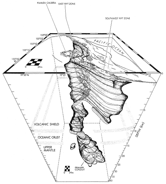
Fig. 6.8
Three-dimensional model of the internal structure of Kilauea volcano. The medium stippled pattern
denotes the structure of the southwest and eastern rift zones that extend outward from the summit
magma reservoir, as well as the main conduit that rises from a depth of 40 km. The reservoir is a lightly
shaded region at a depth of 2 to 7 km. Periodic high-level injection of magma into the rift zones occurs
along the horizon of neutral buoyancy (arrowed pathways) and is associated with the lateral
formation of dikes at 3 km below the volcano's surface.
(Adapted from Ryan, 1987b.)
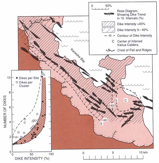
Fig. 6.9
Dike swarms of the ancient Koolau dike complex and Kailua caldera. (the inset shows dike intensity
as well as the number of dikes per cluster and site). This ancient shield caldera and rift zone is
analogous to the modern Kilauea volcano and is used to
interpret the younger volcano's structural framework.
(Adapted from Walker, 1987.)
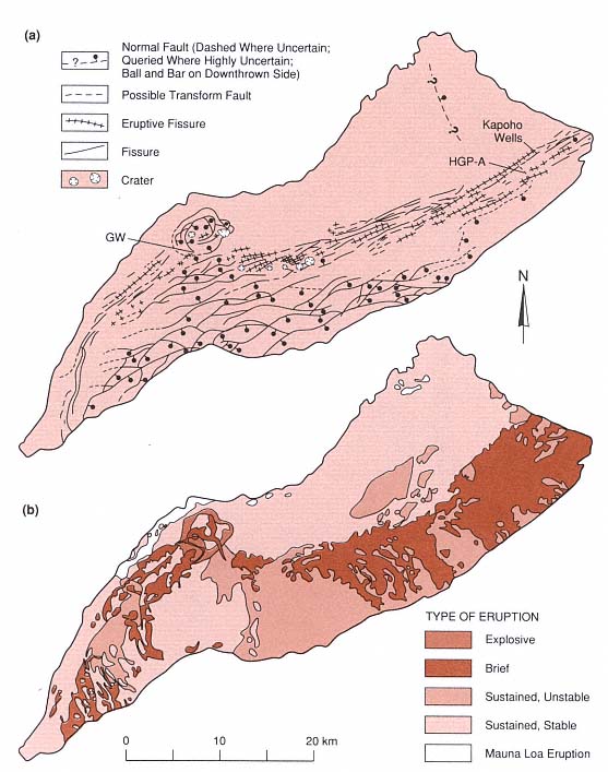
Fig. 6.10
Geology of Kilauea volcano. (a) Structural map depicting Kilauea caldera, pit craters, normal faults,
fissures and eruption fissures. HGP-A is the location of the Hawaii Geothermal Project well in
the Puna District. The Kilauea research drill hole is denoted GW. (b) Map of Kilauea volcano
showing lava flows classified by eruption type.
(Adapted from Holcomb, 1987.)
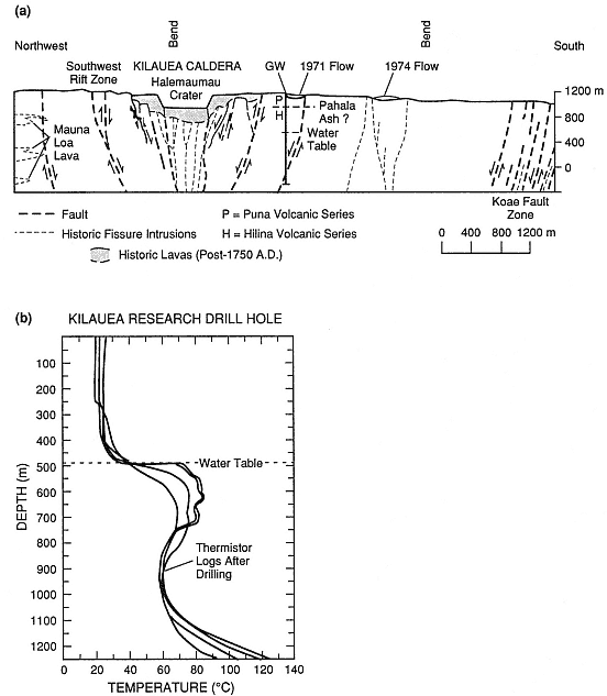
Fig. 6.11
(a) Cross-section of Kilauea caldera including the Kilauea Research drill hole (GW). (b) Temperature
logs from the Kilauea drill hole. There is no increase in temperature until the water table is reached
at a depth of 480 m. Below 725 m, the gradient is conductive
it reaches a maximum of 137°C at a depth of 1250 m.
(Adapted from Zablocki et al ., 1974.)
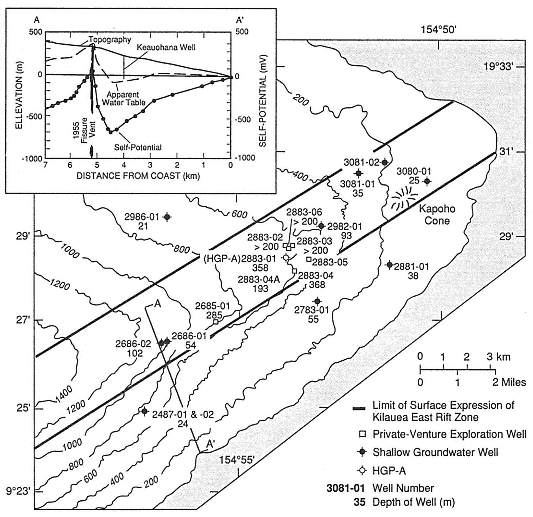
Fig. 6.12
(a) The lower east rift of Kilauea volcano indicating the limits of the surface expression of the rift
and the location of groundwater and geothermal wells. Contour intervals are 200 ft. The inset shows
topography, the apparent water table, and self-potential for profile A—A'.
(Adapted from Thomas, 1987.)
In 1976, a government-sponsored well (HGP-A) was drilled near the center of the east rift zone at an elevation of 200 m and ~300 m east of a spatter rampart formed during the 1955 eruption. This well is located near the intersection of the north-east-trending rift and a northwest-trending, right lateral fault mapped by Holcomb (1987). The drillhole is also 28 km west of and 1043 m lower than Kilauea's summit caldera. It was drilled to a depth of 1968 m and has a bottom-hole temperature of 358°C (Fig. 6.13). The reservoir is located in lava flows and dikes, where Stone and Fan (1978) reported three zones of hydrothermal alteration: (a) 675 to 1894 m—montmorillonite, (b) 1350 to 1894 m—chlorite, and (c) 1894 to 1962 m—actinolite and calcite. These authors concluded that the present-day thermal regime is related to recent
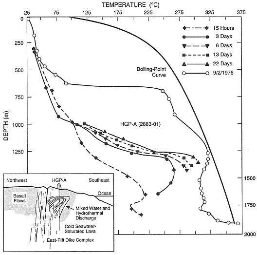
Fig. 6.13
Temperature profiles measured in the Hawaii Geothermal Project well HGP-A. The inset is a
conceptual cross section of the lower east rift of Kilauea that depicts fluid circulation across
the rift zone. Thermal waters leaving the rift to the southeast (downslope) form a plume overlying
the colder fluids below. Drilling on the downslope side of the rift would initially encounter hot
fluids but at greater depths would enter cool aquifers.
magma injection. The fluids are slightly saline but have high concentrations of silica and sulfide (Kroopnick et al ., 1978). Thomas et al ., (1983) calculated that the flowing well produces 50,000 kg/hr: 50% liquid (mixed seawater and meteoric water) and 50% steam. An electricity generating plant has been producing 3 MWe . Because the possibility of an eruption close to the plant was considered in its design, most of the equipment is on skids and can be removed if necessary.
At the time of this writing (1991), five production wells have been drilled near HGP-A. Most of these wells are located within the northern edge of the rift, in line
with fractures and a spatter rampart formed during the 1955 eruption and on the slopes of Puu Honuaula, a cinder cone believed to be between 1500 and 10,000 years old. These were drilled to depths of over 2000 m and have bottom-hole-temperatures of 312 to 334°C. The reservoir begins at a depth of ~1200 m and extends to a depth of at least 2250 m; it consists of a basaltic dike complex composed of near-vertical dike swarms, each separated from the other by brecciated wall rock (Clark and Stewart, 1991). The reservoir is overlain by ~750 m of submarine basalt flows with low permeability and by 450 m of subaerial basalt flows, which are permeable and contain an unconfined aquifer (Clark and Stewart, 1991).
The dikes and fractures of the east rift act as guides for fluid flow, allowing hot fluids to rise parallel to the dikes. The rift also dams water from upslope; the apparent water table rises to the near-surface on the north-west side and plunges to a depth of 400 m on the southeast side (Jackson and Kauahikaua, 1987; Thomas, 1987). Much of the potential sea water inflow is also blocked by rift dikes. Within the rift, where there is adequate fracture permeability and depth (~2000 m), the hydrothermal plume can be drilled and developed. Beyond the southern edge of the rift, one well penetrated thermal fluids at shallow depths but reentered cold sea water below the outflow plume from the rift, as is shown in Fig. 6.13 (Thomas, 1987).
Exploration and production drilling has taken place only along the east rift of Kilauea Volcano; this area is accessible and is located on private land (except for the research well that is sited in the National Park). The southwest rift zone of Kilauea and all rift zones of Mauna Loa, Mauna Kea, and Hualalai have not yet been drilled. These resources have been examined only at the surface during the Thomas et al . (1979, 1983) evaluation of the geothermal resources of Hawaii.