Migration of Magma and Evaluation of Thermal Sources
As is the case for all hydrothermal systems, geothermal system development in Hawaii depends on an understanding of volcanic heat sources and groundwater. In this area, where there is little surface water and a constant volcanic hazard, geoscientists have achieved a good understanding of both of these crucial aspects. Most of the geothermal exploration on the Island of Hawaii is concentrated on Kilauea Volcano, where the storage, migration, and eruption of basaltic magmas is monitored by the Hawaiian Volcano Observatory's geophysical network.
In this area, magma rises buoyantly along a very irregular network of vertical, roughly cylindrical conduits that are marked at the surface by a caldera. Kilauea Caldera, located at the summit of the volcano, consists of concentric collapse craters, the widest of which is 4.5 by 3 km. Helz (1987) has determined that the picritic (~20% olivine phenocrysts) basalt of the 1959 Kilauea eruption originated at depths of 45 to 60 km and rose to the surface at velocities of 0.58 to 0.77 cm/s; which is fast enough to carry along olivine xenocrysts and aggregates.
Eruptions in calderas and along rifts are spectacular—with lava fountains, fast-moving lava flows, and occasional phreatomagmatic activity—however, most of the magma never reaches the surface but comes to rest in a shallow crustal environment. These magma bodies, located within the uppermost 7 km of the crust, are responsible for the heat that drives geothermal systems on Kilauea. Ryan (1987a,b) addressed the reason most magma comes to rest at shallow levels in the crust in his elegant study on the regions of neutral buoyancy. Ryan integrated seismic and surface deformation data with measurements of the physical properties of rock and magmas under pressure to provide information on the variation of crustal rock densities with depth. Below 9 km, all macrofractures, microfractures, vesicles, and joints are eliminated by bulk compression [Fig. 6.7(a)]. Below 7 km, magma is transported buoyantly within the central conduit and the intensity of hydraulic fracturing is high. Between 7 and 2 km, the in-situ densities of the fractured crustal rock and the magma are similar, and a magma
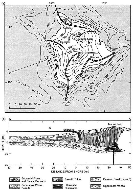
Fig. 6.6
(a) Map of the island of Hawaii shows the major rift-zones of the five overlapping shield volcanoes.
Elevation and depth contours are in 500-m intervals on land and 1,000-m intervals offshore.
(b) This schematic cross-section of the central and western Mauna Loa shield is based on the
P-wave velocity and density models of Hill and Zucca (1987).
body is formed at a point where buoyant rise is no longer possible; the fact that this is an increasingly aseismic region indicates a higher fluid/rock ratio (Fig. 6.7). The center of neutral buoyancy is located at depths of 2.5 to 4.5 km, suggesting a correspondence between the depths at which magma is in mechanical equilibrium with the surrounding rock and the depth of Kilauea's subcaldera magma reservoir. From depths of 0 to 2 km, the deformed and fractured crust allows vesiculating magmas to pass through dikes. As the volcano grows, the summit (subcaldera) magma reservoir and associated rift system is elevated and achieves mechanical equilibrium within the lava shield (Ryan, 1987a,b). The entire igneous system rises with both time and a continuing supply of magma, but it retains the same depths below the volcano's surface. This is an important concept to keep in mind when evaluating thermal sources within shield volcanoes similar to those at Kilauea and Mauna Loa.
Ryan (1987a,b) determined that most magma movement into rift zones from the summit reservoir is at a depth of 3 km—a level of neutral buoyancy. Magma moves rapidly along the rift until the fluid pressure falls below that of the tensile strength of the host rock. Ryan (1987a,b) cites three types of dike formation.
(1) Slow movement of magma, with a gradually enlarging fracture front. The dike top rises toward the surface and the bottom descends at a similar rate.
(2) Rapid movement of magma, during which the dike top rises rapidly and, simultaneously, the base sinks. Subsequent pressure reduction narrows the dike and restricts it to the neutral buoyancy zone.
(3) Pressure differentials within the growing dike form an intrusion shaped like a doubly serrated knife. The "serrations" have amplitudes of 2 to 6 km. Where a rising dike intersects the surface, cracks open and a rift eruption begins, as is depicted in Fig. 6.8.
These models have been developed from data collected over the last 20 or 30 years, when activity at Kilauea volcano has been mostly along the rifts.
A well-exposed analog to Kilauea volcano is the Koolau volcano on Oahu, for which Walker (1986; 1987) described the internal structure. The shield of Koolau was constructed by small but frequent eruptions of basaltic magma. Erosion has eroded the 57-km-long volcano to a depth of ~1 km and exposed the plumbing within its shield. Kailua caldera, located at the southeast end of the Koolau volcano, is analogous to Kilauea Caldera and consists of mainly thick, massive lava flows. It lacks the thin pahoehoe lava flows that characterize the Kilauea shield volcano. Breccias within the 4-km-diameter Kailua caldera may represent either periods of collapse or phreatic blasts. A rift extending northwest from the caldera is composed of ~5100 dikes over its 3.3-km width, as is illustrated in Fig. 6.9. The rift
Fig. 6.7
Earthquake abundance and in-situ density with depth beneath Kilauea volcano.
(a) Distribution of earthquakes beneath Kilauea's summit region, to a depth of 20 km.
The dark pattern refers to the volume beneath the whole Kilauea caldera and the light
pattern refers to the volume beneath only Halemaumau crater. The aseismic
region from 2 to 7 km is believed to have high magma:rock ratios.
(Adapted from Ryan, 1987a.)
(b) In-situ densities of olivine tholeiitic basalt near its liquidus, volcanic shields, and the upper
mantle below Hawaii. The depth region of density crossover coincides with the subcaldera region of
magma storage below Kilauea; based on data from Salisbury and Christensen, 1976; Fuji and
Kushiro, 1976; and Zucca, Hill, and Kovach, 1982.
(Adapted from Ryan, 1987a.)
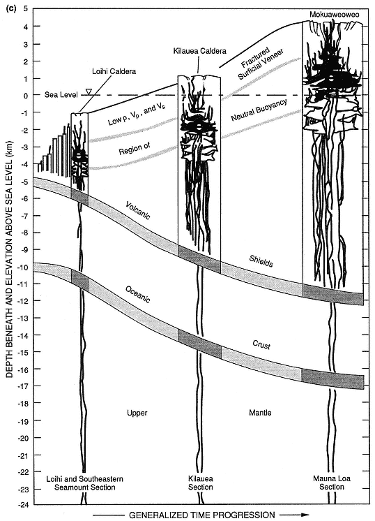
Fig. 6.7
(c) Schematic diagrams show the evolution of oceanic shield volcanoes such as Hawaii, progressing
from Mokuaweoweo caldera of Mauna Loa volcano (oldest) to the Loihi seamount (youngest).
Low r = low density; Vp = P-wave velocity; and Vs = shear-wave velocity. As the volcano grows,
it carries with it its contractancy profile and regions of fracturing; the region of neutral buoyancy
rises from below sea level to well above sea level.
(Adapted from Ryan, 1987b.)
follows listric faults that dip outward on either side of the Koolau shield. Dikes range in width from <5 to 670 cm, with a median of 53 cm, and typically have glassy, chilled margins and sheetlike cooling joints that are perpendicular to dike margins. These dikes sometimes occur in clusters (or swarms) as wide as 20 m, in which successive members were injected either along the margins or inside preceding dikes. Within such clusters, dikes may make up 100% of the rock.
Most of Hawaii's recent exploration and drilling for hydrothermal development has been along the east rift zone of Kilauea Volcano. The subaerial part of Kilauea is 80 km long and 20 km wide and still growing. [For the most recent compilation of geologic maps, refer to Holcomb (1987)]. Kilauea rises to an elevation of 1240 m above sea level and serves as a topographic barricade to the trade winds and rainfall; as a consequence, the eastern slopes of the volcano are covered with dense vegetation and the southwestern slopes are a desert— an important observation to consider in planning geothermal development. Kilauea is young and very active: 90% of the surface is younger than 1000 years (Holcomb, 1987). Approximately 50% of the volcano surface is covered with lavas that overflowed the summit caldera, but such an event has not occurred for 200 years; 81% of the lava flows are pahoehoe , and aa flows make up a smaller volume. During the last 500 years, periods of sustained summit activity have included only minimal flank (rift) activity. However, when there is little activity at the summit, other than caldera collapse, the flanks are more active.
Kilauea's caldera is actually a collection of nested (but not concentric) calderas, in which the outermost visible caldera is 7.5 by 5.1 km and the innermost (Halemaumau Crater) is 0.9 km in diameter. The subaerial portion of Kilauea's east rift zone is 50 km long and 2 to 3 km wide; the actual rift extends about 50 km further below sea level. Figure 6.10 illustrates the surface manifestations of rift tectonic and volcanic activity: normal faults, open fissures, and pit craters; cinder cones, spatter ramparts, tuff cones, and steaming ground are associated with these features, but are not shown on this map.