Taming the Organic Growth
When the French invaded Algiers, they settled in the old city. Uncertain about their future in Algeria, they kept urban intervention to a minimum during the first years of occupation. As seen in the previous chapter, the main operations—the opening of the Place du Gouvernement and the widening of the main arteries, Rue Bab el-Oued and Rue Bab Azzoun—depended solely on militaristic and practical necessities.
Even in the 1840s, when the French became convinced that they would stay in Algeria for good, no clear role was envisioned for Algiers.
On the one hand, plans for its future did not extend beyond military functions, as articulated by the governor general of Algeria in 1844: "Algiers must rather be a place of war, which forms the citadel of Algeria, than a town of commerce."[2] Accordingly, an early planning decision called to replace the Ottoman fortifications with new fortifications "à la Vauban."[3] Built between 1841 and 1848, the new fortifications tripled the intra-muros, while enhancing the emphasis put on defense. On the other hand, a second camp approached city building with a broader vision. Arguing that French domination in Algiers would be permanent, a group of technocrats advocated converting Algiers from a battlefield (champ de bataille ) to a workplace (champ de travail ), where a large European population would either mix with local Arabs or live next to them in peace and friendship. To enable economic development, construction of harbor facilities and commercial buildings had to be given priority.[4]
Meanwhile, the growing population of the city had already pushed the city limits toward the south, creating a major settlement in Mustafa. As early as 1839, official reports pointed to the high densities in the old town, especially to the overcrowding of the Marine Quarter and the lower casbah, where most of the fifteen thousand Europeans lived. By this time, the population of Algiers was around forty-eight thousand.[5]
Attempts at a plan that would control the urban growth and introduce a "rational" street system go back to the early 1840s, but the first project to be approved by the ministry of war dates from 1846. The project replaced the Ottoman fortifications by large boulevards that encircled the casbah. The Boulevard Vallée to the north of the casbah and the Rue Rovigo to the south, which climbed the hills with its dramatic curves, provided communication with the interior of the country (Fig. 28). Rue du Rampart (later Boulevard de l'Impératrice, Boulevard de la République, and now Boulevard Che Guevara), completed in the 1860s, defined the border between the edge of the city and its harbor.[6]
Taking into consideration the organic extension of the city southward, a second project from 1846 (Plan Guiauchain) moved the center from the Place du Gouvernement to the site of the demolished Bab Azzoun gate. The Bab Azzoun Quarter, sheltering both residential and commercial functions, had a "double physiognomy": corresponding to its topography, the lower section displayed a rectilinear arrangement of streets, with the Rue d'Isly crossing it transversely and opening up to the Place d'Isly (later named Place Bugeaud) at its center, while the upper section was cut through by curving arteries. The short streets

Figure 28.
Plan of Algiers, c. 1900. (1) Rue d'Isly, (2) Rue Rovigo, (3) Boulevard Vallée,
(4) Rue du Rampart, (5) Place de la République.
linking the Rue d'Isly to the heights were, if straight, painfully stepped. One among them, Rue Joinville, with its 150 steps, was considered by Lespès to be "a curiosity . . . a challenge thrown at nature and also a picturesque misinterpretation of urbanism."[7]
While the area around Bab Azzoun developed as a European quarter, not much happened in Bab el-Oued, except for the establishment of a few minor industries and a couple of mills. A planned working-class neighborhood, the Cité Bugeaud, was designed for this quarter in the late 1840s on the initiative of a German architect, M. Lichtenstein; it offered refuge to victims of the Janina fire, which had devastated the area surrounding the Janina Palace as well as the palace itself (Fig. 29).[8]
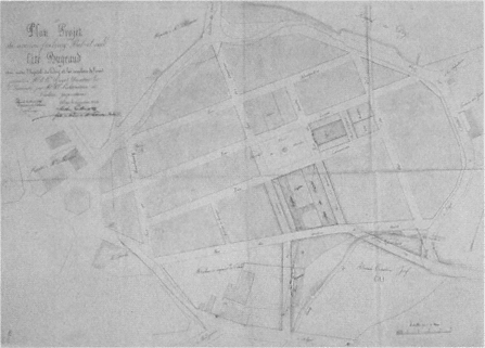
Figure 29.
Plan of Cité Bugeaud, Bab el-Oued Quarter, c. 1845.
Several projects in the 1850s called for the extension of Algiers outside its fortifications toward the south. Chassériau's "Napoléonville" from 1858 proposed to sever the European settlement completely from the Muslim town and to settle sixty thousand Europeans in two-story houses filling an orthogonal grid in Mustafa (Fig. 30). The houses were grouped around green spaces, and densities did not exceed 282 people per hectare. Given the realities of Algiers, Chassériau's project was considered idealistic and "too beautiful to become real." Two similar projects, the Vigourous-Caillat plan and the MacCarthy-Génévay plan, reiterated the same ideas the same year. None of these proposals stirred an interest among municipal authorities, whose main concern focused on the private interests of landowners in intro-muros . In addition, Mustafa obtained its autonomy as an urban unit in 1871 and pursued its own ad hoc development.[9]
On the road that led from Bab Azzoun to Mustafa, another quarter, that of Agha, had developed organically since the 1840s along Rue de Constantine, which led to the town of Constantine. Agha attracted some commercial enterprises, as well as a considerable number of caba-

Figure 30.
Charles-Fréderick Chassériau, plau for Napoléonville, 1858.
rest that capitalized on the proximity of the army camp and the Champ de Manoeuvres, the parade ground. According to Fromentin in 1852, the Agha Quarter was "an interminable line of restaurants and cafés [buvettes ]," forming a striking contrast to the sombre Muslim town.[10]
Perhaps the most significant urbanistic event of the 1860s was the completion of the Boulevard de l'Impératrice, which extended from one end of the city to the other within the French fortifications, unifying the waterfront (see Fig. 19). This boulevard enhanced the planning of adjacent areas, among them the Square Bresson (later Place de la République, then Square Aristide Briand; now Square Said), which definitively welded the old town to the new one. Defined on one side by the Grand Theater, one of the first French monuments in town, Square Bresson opened to the waterfront on the other. It was lushly planted and decorated with statues; the music stand in the center was topped by a dome from a demolished sixteenth-century building. The Boulevard du Centaure (later Boulevard Gambetta, now Ourida Meddad), leading from Square Bresson to the hills behind and following the line of the former Ottoman fortifications, was an "immense stairway" with about two hundred steps and periodic platforms (Figs. 31 and 32). On the up-

Figure 31.
Plan showing the juncture of the casbah and the French city.
per parts of the Boulevard du Centaure the first casino in Algiers was built in the 1880s in an effort to accommodate the British tourists and to turn the city into an hivernage (winter resort).[11]
The Rue de la Liberté, parallel to the Boulevard de l'Impératrice, was also laid out during the 1860s, simultaneously with a network of or-

Figure 32.
View of Square Bresson, with the Grand Theater in the foreground, c. 1900.
thogonal streets, creating a new neighborhood (Fig. 33). Due to the 10-meter width of its streets and the uniformity of the buildings lining them, this longitudinal quarter was considered the "best designed," the "best ventilated," and the "best built." The two government buildings back to back to each other in the center, the Central Post Office facing the Boulevard de l'Impératrice and the Palace of Justice the Rue de la Liberté, added further prestige to this strip.[12]
Mustafa's autonomy lasted until its reannexation in 1904. During the 1870s it grew considerably, in part due to employment resulting from the construction of the Civil Hospital. Random development of the neighborhood was difficult to correct, however, and the attempt of a master plan to regularize the quarter failed, because it did not take into consideration topographic characteristics. The Rue de Télemy (now Salah Bouakouir) remained a unique intervention. Originally conceived as a 10-mater-wide corniche that would span the heights of the city and offer spectacular views of the bay, its width was reduced to 7 meters for reasons of economy.[13]
The lifting of the forty years of military regime in favor of civilian rule in 1871 had important consequences for the city of Algiers. The military terrains and easements occupied a huge area encircling the city; within the fortifications, this amounted to 160 hectares, as opposed to the 86 hectares left for public use. The city walls had also become obsolete, acting only as artificial barriers between Algiers proper and its

Figure 33.
Plan of Algiers, c. 1900. (I) Mustafa, (2) Jardin d'Essai, (3) Boulevard Laferrière, (4) Rue de Télemy, (5)
Rue de Constantine, (6) Rue de la Liberté, (7) Boulevard de l'Impératrice, (8) Bab el-Oued, (9) Boulevard
Guillemin, (10) Square Nelson, (11) Rue Randon.
suburbs. After negotiations that lasted over a decade, the demolition of the ramparts began in 1894. The turbulent negotiations themselves constituted one of the two main urbanistic activities from the 1880s to the beginning of the demolitions (with the exception of one new street—the extension of the Rue Randon).[14]
The other major event in the planning of the history of Algiers at the time was the Projet de transformation, d'extension et d'embellissement de la ville d'Alger , prepared by Eugène de Redon in 1884. Taking into consideration the inevitable growth of the city southward, Redon proposed to connect Algiers and Mustafa by placing a maritime quarter in the Bab Azzoun area. Sheltering new sea and land transportation installations, a train station, and a large commercial area, and facing a new basin, this quarter would replace the Bab Azzoun fort. Redon extended the Boulevard de la République for 900 meters toward Agha and foresaw the development of the zone gained by the demolition of the fortifications, around a main boulevard that connected the waterfront to the heights—later realized as the Boulevard Laferrière.[15]
To compensate for the real estate lost by the military in the redesign of the Marine Quarter, Redon introduced a military quarter in the north, near Bab el-Oued. This quarter was organized by means of three arteries parallel to a 630-meter-long and 25-meter-wide boulevard on the waterfront, the Avenue Bab el-Oued; other streets perpendicular to those would ensure excellent ventilation. Furthermore, Redon proposed to renovate the Bab el-Oued Quarter entirely in an effort to balance development in the north of the city with the expansion of the southern suburbs. The corniche boulevard would be continued, and six principal roads parallel to it would be intersected by perpendicular streets, forming, once again, a well-connected and spacious network.[16]
As Lespès argued, even though actual city building was minimal between 1880 and 1896, an important development had taken place: the city administrators had formed a clear opinion on how to deal with the problems of Algiers. They understood that the future of the city was based on its merging with suburbs in the north and south; the Mustafa and Bab el-Oued quarters had to be incorporated into Algiers proper. In addition, Algiers was now considered the capital of French Africa and potentially a great city of commerce, not a mere military and naval outpost. In 1896, its population was over 120,000 people; of these, about 92,000 lived in Algiers proper and 35,000 in Mustafa.[17]
The heyday of building activity in Algiers occurred between 1896 and 1914. On the land bought from the army by the city administration, the
municipality built sixty-six roads. The impressive developments to the south underscored the inevitable shift of the center: the Rue d'Isly, until then dotted with makeshift shops and insignificant buildings, became lined with large and "beautiful" structures; another well-built neighborhood emerged in the Isly Quarter and around the newly extended Bugeaud ramp; the terrains between Rue de Constantine and Boulevard Carnot also were developed. To the north, the Esplanade Quarter was built around a central square, the Square Nelson (now Square d'Istanbul); the heights of Bab el-Oued, below the el-Kattar cemetery, acquired twenty streets lined with impressive buildings. In addition, two new boulevards replaced the former fortifications: Boulevard Laferrière (now Mohamed Khemisti) to the south and Boulevard Guillemin (now Abderahmane Taleb) to the north, both alternating ramps with leveled platforms to soften the topography. The lushly planted central strips of these avenues acted as longitudinal mini-parks, compensation to some degree for the lack of open space in the city. Another important urbanistic gesture was the decision to create a large public park in the Jardin d'Essai in 1912.[18]
This intensive building activity could not always be controlled and regulated. While certain urban fragments benefited from careful plans, others were not so lucky. For example, the lower and upper sections of Mustafa, as well as Belcourt and Hamma, grew fast but without any plan (Fig. 34).[19] Inevitably, the more prestigious quarters became the focus of attention and benefited from urban design in the "grand manner," albeit in a piecemeal fashion. The location of a number of new monuments, such as the new Prefecture on the Boulevard de la République and the Central Post Office on Boulevard Laferrière—both built in 1906 in neo-Islamic styles—emphasized further the primacy of certain quarters (Fig. 35).
The ad hoc growth pattern set by Mustafa, Belcourt, and Hamma became the norm until 1930. Not only did the built fabric of the city begin to climb up farther onto the hills, appropriating any available land, but also the former pattern of "Moorish-style" villas in gardens on the heights gave way to much denser settlement patterns; the original owners of such villas now preferred to live in the fashionable apartments downtown. Densities in the older quarters of the city rose, too, due to the increasing building heights and new construction on every leftover open space. Yet it was the linear expanse that most overwhelmed people concerned with the future of Algiers. In 1930, Algiers extended for 8 kilometers along the shore from St. -Eugène to Hussein-Dey, in

Figure 34.
Schematic plan showing the area occupied by Algiers in 1930. The dark lines on the left and the right indicate
the area covered in the 1948 regional plan.

Figure 35.
View of the Prefecture on Boulevard de la République. The arcades of the
harbor are in the foreground.
what was repeatedly characterized at the time as "chaotic growth." In between the built areas lay land that belonged either to the military or to the public (such as hospitals).[20]
Unlike other French colonial cities, Algiers was not strictly segregated into European and indigenous quarters. The exception was the casbah with its almost entirely Algerian population; other areas showed varying degrees of population mixture. In 1926, 212,000 people lived in Algiers (including Mustafa). The intra-muros had 112,000 residents: about 45,000 were Algerians, mostly concentrated in the casbah, and 67,000 were Europeans residing in the quarters to the south of the casbah and in the less affluent Marine Quarter. Mustafa's population consisted of 64,000 Europeans and 10,000 Muslims. Bab el-Oued had only 800 Muslims, out of a total of 26,000 residents.[21]